The Underline - Segment 6
     BUILD Grant FY 2018
         Appendix K

Underline Limited Environmental
            Phase I
←
→
Page content transcription
If your browser does not render page correctly, please read the page content below
The Underline - Segment 6
BUILD Grant FY 2018
Appendix K
Underline Limited Environmental
Phase I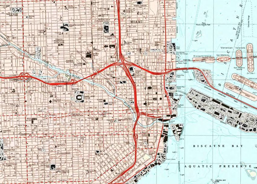
LIMITED PHASE I
      ENVIRONMENTAL SITE ASSESSMENT
     10 MILE CORRIDOR PARK, METRORAIL RIGHT-OF-WAY
    MIAMI RIVER TO DADELAND SOUTH STATION ALONG US-1
                      MIAMI, FLORIDA

                        - PREPARED FOR –

Miami-Dade County Parks, Recreation and Open Spaces Department

                         - PREPARED BY –

                 MILIAN, SWAIN & ASSOCIATES, INC.
                       IN ASSOCIATION WITH
      AMEC FOSTER WHEELER ENVIRONMENT & INFRASTRUCTURE, INC.
                      5845 NW 158th Street
                    Miami Lakes, Florida 33014

          Amec Foster Wheeler Project Number 6783-16-2797

                           May 18, 2016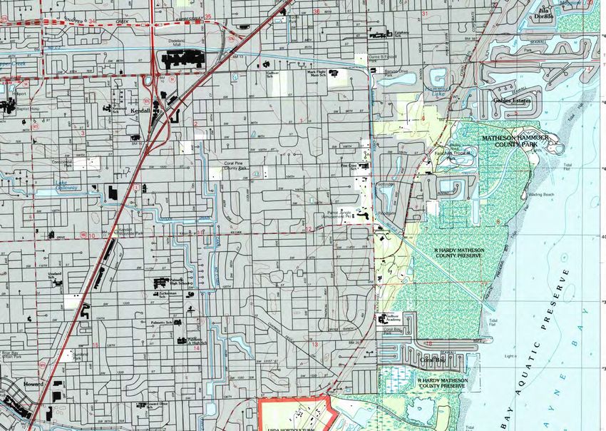
10 Mile Corridor Limited Phase I, Miami FL
Amec Foster Wheeler
Project Number 6783-16-2797
May 18, 2016

                                                        TABLE OF CONTENTS
1.0   INTRODUCTION ........................................................................................................... 1-1
  1.1   Purpose ....................................................................................................................... 1-1
   1.2        Detailed Scope of Services ...................................................................................... 1-2
   1.3        Significant Assumptions............................................................................................ 1-3
   1.4        Limitations, Exceptions, Special Terms, and Conditions ..................................... 1-3
   1.5        User Reliance ............................................................................................................. 1-4
2.0   Site Description .............................................................................................................. 2-1
  2.1   Location and Legal Description ............................................................................... 2-1
   2.2        Site and Vicinity General Characteristics ............................................................... 2-1
   2.3        Current Uses of the Adjoining Properties............................................................... 2-2
3.0   Physical Setting.............................................................................................................. 3-1
  3.1   Topography ................................................................................................................. 3-1
   3.2        Soils ............................................................................................................................. 3-1
   3.3        GROUNDWATER ...................................................................................................... 3-2
4.0   USER-PROVIDED INFORMATION ............................................................................ 4-1
5.0   ENVIRONMENTAL RECORDS REVIEW .................................................................. 5-1
  5.1  Standard Environmental Records Sources............................................................ 5-1
       5.1.1         Federal Records................................................................................................. 5-3
       5.1.2         State and Local Records .................................................................................. 5-5
       5.1.3         EDR Proprietary Records ................................................................................. 5-8
6.0   HISTORICAL RECORDS REVIEW ............................................................................ 6-1
  6.1   Aerial Photographs .................................................................................................... 6-1
   6.2        Historical Topographic Maps ................................................................................... 6-1
   6.3        Fire Insurance Maps .................................................................................................. 6-1
   6.4        Previous Reports or Records of Proceedings ....................................................... 6-1
   6.5        Historical Use Information on Adjoining Properties .............................................. 6-1
7.0   SITE RECONNAISSANCE........................................................................................... 7-1
  7.1   Methodology and Limiting Conditions..................................................................... 7-1
   7.2        General Site Setting .................................................................................................. 7-1
   7.3        Aboveground Storage Tanks ................................................................................... 7-1
   7.4        Underground Storage Tanks.................................................................................... 7-2
   7.5        Odors ........................................................................................................................... 7-2
   7.6        Pools of Liquid ............................................................................................................ 7-2

                                                                         i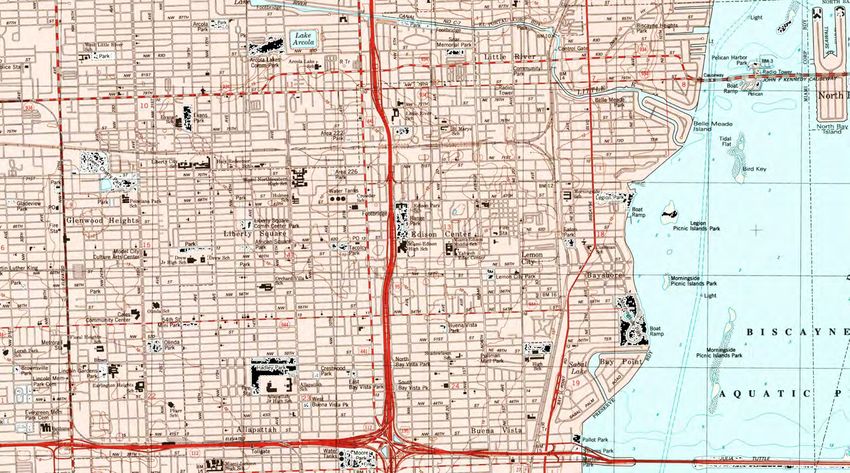
10 Mile Corridor Limited Phase I, Miami FL
Amec Foster Wheeler
Project Number 6783-16-2797
May 18, 2016

  7.7       Pits, Ponds, or Lagoons ............................................................................................ 7-2
  7.8       Drums .......................................................................................................................... 7-2
  7.9       Hazardous Substances and Petroleum Products Storage Containers ............. 7-2
  7.10      Unidentified Substance Containers......................................................................... 7-2
  7.11      Polychlorinated Biphenyls ........................................................................................ 7-3
  7.12      Stains or Corrosion .................................................................................................... 7-3
  7.13      Drains, Sumps, or Other Discharge Features ....................................................... 7-3
  7.14      Stained Soil/Pavement or Stressed Vegetation .................................................... 7-3
  7.15      Solid Waste or Fill Dirt............................................................................................... 7-3
  7.16      Wastewater ................................................................................................................. 7-3
  7.17      Wells ............................................................................................................................ 7-3
  7.18      Septic Systems .......................................................................................................... 7-4
  7.19      Wet Areas or Surface Water Bodies ....................................................................... 7-4
8.0      INTERVIEWS ................................................................................................................. 8-1
9.0      FINDINGS ....................................................................................................................... 9-1
10.0     OPINION ....................................................................................................................... 10-1
11.0     CONCLUSIONS ........................................................................................................... 11-1
12.0     REFERENCES ............................................................................................................. 12-1
13.0     SIGNATURE(S) OF ENVIRONMENTAL PROFESSIONAL(S) ............................ 13-1
14.0     QUALIFICATIONS OF ENVIRONMENTAL PROFESSIONAL(S) ....................... 14-1

                                                                      ii
10 Mile Corridor Limited Phase I, Miami FL
Amec Foster Wheeler
Project Number 6783-16-2797
May 18, 2016

TABLES                                                               PAGE NO.

TABLE 1                ENVIRONMENTAL DATABASE SEARCH RESULTS             5-1

FIGURES
FIGURE 1              SITE LOCATION
FIGURE 2A – 2C        TOPOGRAPHIC MAPS
FIGURE 3              MAP OF SITES CONSIDERED AS RECS

APPENDICES
APPENDIX A            MIAMI-DADE COUNTY PROPERTY APPRAISER INFORMATION
APPENDIX B            EDR RADIUS MAP REPORT (CD ATTACHED)
APPENDIX C            MAPS ILLUSTRATING LISTINGS
APPENDIX D            PHOTO LOG

                                             iii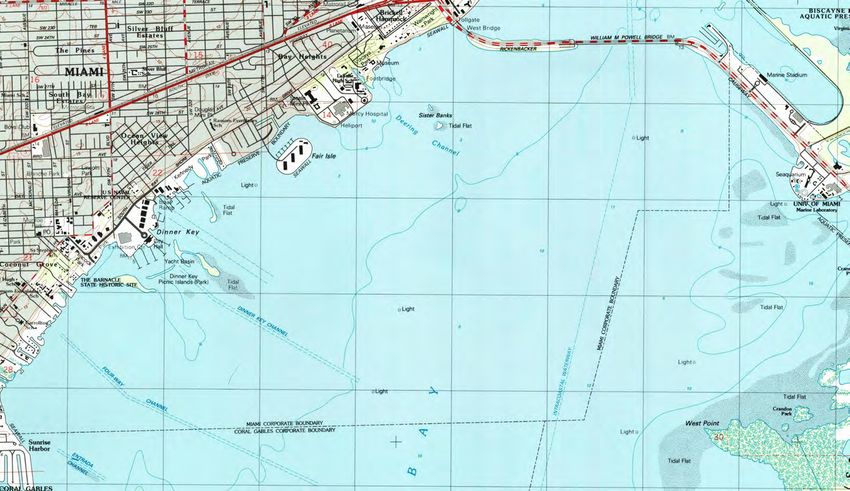
10 Mile Corridor Limited Phase I, Miami FL
Amec Foster Wheeler
Project Number 6783-16-2797
May 18, 2016

                                       EXECUTIVE SUMMARY

Milian, Swain & Associates, Inc. (MSA) and its sub consultant Amec Foster Wheeler
Environment & Infrastructure, Inc., (Amec Foster Wheeler) were retained by Miami-Dade
County Parks, Recreation, and Open Spaces (MDPROS) to conduct a Limited Phase I
Environmental Site Assessment (ESA) for 10 miles of The Underline within the Miami-
Dade Metrorail right-of-way. The study area (site) extends from the Miami River to the
Dadeland South Station along US-1 in Miami, Florida. Due to the linear nature of the
site and as proposed by MSA and Amec Foster Wheeler and approved in concept by
DERM and MDPROS, this Limited Phase I ESA conforms with the scope and limitations
of ASTM International (ASTM) Standard E 1527-13 except for aspects which are not
applicable to a linear site or related to a property sale and purchase transaction.

The purpose of this Phase I ESA is to identify known environmental conditions or
concerns associated with the site, which include any recognized environmental
conditions (RECs) associated with the site. RECs do not include de minimis conditions
that generally do not present a material risk of harm to human health or the environment
and that generally would not be the subject of an enforcement action if brought to the
attention of appropriate governmental agencies. The results of our Limited Phase I ESA
are summarized below.

The subject property consists of an approximate 10 mile long by approximately 170 feet
wide site. The site is currently partially paved, landscaped, or undeveloped along its 10
mile length.

SITE HISTORY

Based on a review of reasonably ascertainable records, the site was developed into a
rail track in 1984 for the Miami-Dade Transit (MDT) Metrorail (the property owner). Prior
to development, the site was a right of way for Interstate road US-1, and a right-of-way
for a FECI railroad track.

SITE RECONNAISSANCE

Mr. Jonathan Bulley of Amec Foster Wheeler conducted a site reconnaissance on March
31, 2016. The site reconnaissance was performed to identify obvious visual indications
of present or past activities that may have contributed to environmental concerns at the
site.

                                              iv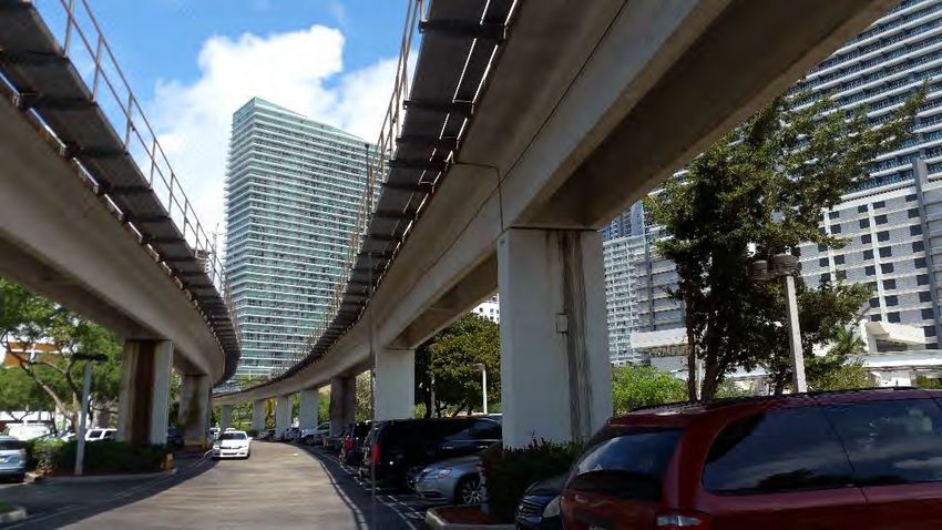
10 Mile Corridor Limited Phase I, Miami FL
Amec Foster Wheeler
Project Number 6783-16-2797
May 18, 2016
ENVIRONMENTAL RECORDS
A review of the federal and state records, including a proprietary records summary
provided by Environmental Data Resources, Inc. (EDR), a third-party provider of
environmental and land use records, indicates that properties of environmental concern
are located within a search distance of 500 feet on each side of the site. Amec Foster
Wheeler has screened the identified properties for significance with respect to their
potential impact on the site based on reasonably ascertainable information obtained
from the records review and the site reconnaissance.
The following RECs and other environmental concerns were identified during the
completion of this Limited Phase I ESA:
An area located approximately 570 feet north of the Vizcaya Station and
approximately 70 feet to the east of the Metrorail tracks was observed to be filled
with trash, debris or other solid waste during the site reconnaissance and is
considered a REC.
Nineteen additional adjacent and surrounding properties along the site within 500
feet on each side of the site with documented contaminants are considered
RECs.
CONCLUSIONS
This Limited assessment has revealed evidence of recognized environmental conditions
in connection with the site. The identified RECs will be further reviewed during the
development of the sampling and analysis plan for the Phase II investigation of the site.
LIMITATIONS
This Executive Summary is provided as a summary only, and should be used only in
conjunction with a full review of the complete Limited Phase I ESA report. This work
was completed under the contract terms and conditions presented in the MSA revised
scope of services dated Feb 23, 2016.
v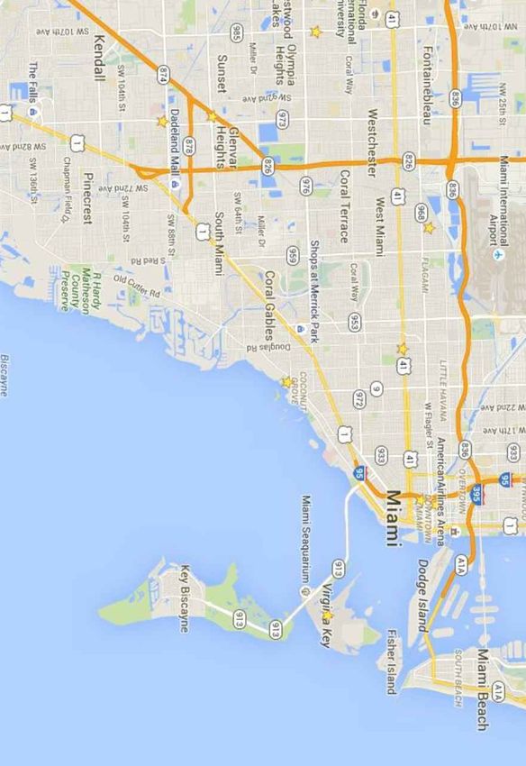
10 Mile Corridor Limited Phase I, Miami FL
Amec Foster Wheeler
Project Number 6783-16-2797
May 18, 2016

1.0 INTRODUCTION

Milian, Swain & Associates, Inc.'s (MSA) subconsultant, Amec Foster Wheeler
Environment & Infrastructure, Inc. (Amec Foster Wheeler), conducted a Limited
Environmental Site Assessment (ESA) for 10 miles of The Underline within the Miami-
Dade Metrorail right-of-way site extending from the Miami River to the Dadeland South
Station along US-1 in Miami, Florida (the site or subject property). MDPROS intends to
develop the property into a linear park, urban trail, and living art destination.

Our services were conducted in accordance with industry-accepted standards. The
services included a review of federal and state records/databases, historical documents,
and a site reconnaissance. MSA and Amec Foster Wheeler’s qualifications and
limitations for this Limited ESA are provided under the appropriate sections of this report.

Before the investigation was initiated a preliminary meeting with Wilbur Mayorga, RER’s
Chief of the Pollution Control Division, took place with MSA and Amec Foster Wheeler to
discuss the project and the limits of the investigation to be performed. Because there is
no transaction of property there is no need to strictly adhere to the ASTM requirements
that are related to property transactions. Both, RER and MDPROS gave tentative
approval to proceed as suggested.

1.1 PURPOSE

The purpose of the Limited ESA was to document current and historical information on
the subject property and in the site vicinity (within 500 feet laterally of the property) to
identify actual and potential environmental concerns relative to the site. The report is
intended to assist the Miami-Dade County Parks, Recreation, and Open Spaces
(MDPROS) with the evaluation of the risk of adverse environmental impact to the subject
property. Information from the ESA report is intended to be used for the design of a
Phase II sampling and analysis program to be developed for review by MDPROS and
the Miami-Dade County Department of Environmental Resources Management (DERM)
as the next step in the environmental evaluation of the site.

The goal of the Limited Phase I ESA process is to identify recognized environmental
conditions (RECs). The term REC means the presence or likely presence of any
hazardous substances or petroleum products in, on, or at a site: (1) due to any release
to the environment, (2) under conditions indicative of a release to the environment, or
(3) under conditions that pose a material threat of a future release to the environment.
De minimis conditions are not RECs. A de minimis condition generally does not present

                                             1-1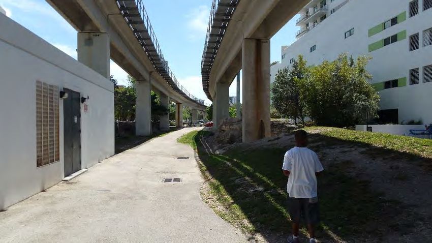
10 Mile Corridor Limited Phase I, Miami FL
Amec Foster Wheeler
Project Number 6783-16-2797
May 18, 2016

a threat to human health or the environment and generally would not be the subject of
an enforcement action if brought to the attention of appropriate governmental agencies.

Separate and distinct from a REC are two other types of conditions that may be noted in
a Phase I ESA: a controlled REC (CREC) or historical REC (HREC).

A CREC is a REC resulting from a past release of hazardous substances or petroleum
products that has been addressed to the current satisfaction of the applicable regulatory
authority (for example, as evidenced by a no further action [NFA] letter or the equivalent,
or meeting risk-based criteria established by the regulatory authority), with hazardous
substances or petroleum products allowed to remain in place subject to the
implementation of required controls, such as site use restrictions, activity and use
limitations (AULs), institutional controls, or engineering controls.

An HREC is a REC from a past release of any hazardous substances or petroleum
products that has occurred in connection with the site and has been addressed to the
satisfaction of the applicable regulatory authority (using current criteria) or meets the
unrestricted residential use criteria established by the regulatory authority and applicable
at the time of this Limited Phase I ESA without subjecting the site to any required
controls.

1.2 DETAILED SCOPE OF SERVICES

A Limited ESA for the Site was conducted. Based on the linear nature of the site, the
Limited ESA scope as proposed and approved by DERM and MDPROS was designed
to adhere to the applicable aspects of Guidance Document E-1527-13 - ASTM Standard
Practice for Environmental Site Assessments: Phase I Environmental Site Assessment
Process. The deviations from the ASTM standard are designed to better serve the
intended purpose of the report – to provide the basis for the design of a Phase II
sampling and analysis plan for the site. Because there is no proposed property sale or
purchase transaction, the elements of the ASTM guidance that are designed only to
provide protection for property purchasers, were not included. The exclusion of the
property transaction aspects of the ASTM standard were discussed during separate
planning meetings and telephone conversations with DERM and MDPROS. DERM
agreed with the modification of the study area to address the linear nature of the
property and determined that the exclusion of property transaction aspects of the ASTM
Standard should be discussed with MDPROS. MDPROS agreed that, because there
would be no property transaction, it would not be necessary to adhere to the property
transaction aspects of the ASTM Standard. MDPROS also indicated that groundwater
would not be used for irrigation or any other purpose in their planned used for the

                                             1-2
10 Mile Corridor Limited Phase I, Miami FL
Amec Foster Wheeler
Project Number 6783-16-2797
May 18, 2016
property. As such, potential groundwater impacts to the site are not a significant
element of this ESA. This Limited ESA involves four separate tasks as follows:
Task 1 - Records Review
Amec Foster Wheeler conducted a search of reasonably ascertainable federal, state,
and local record databases to identify listings of surrounding properties located in
proximity to the site.
Task 2 - Field Reconnaissance
The field reconnaissance was performed by an Environmental Professional (EP), as
defined in the standard, in an effort to evaluate the visual evidence of environmental
concerns that may be present on the property.
Task 3 - Report Preparation
After analysis of archival data and site observations, an Amec Foster Wheeler
Environmental Professional prepared this Limited Phase I ESA report. The report
presents and discusses available data in addition to providing opinions regarding
potential for adverse environmental conditions. The report includes figures and site
photographs to illustrate key points.
1.3 SIGNIFICANT ASSUMPTIONS
The environmental professionals preparing this report have made a reasonable effort to
obtain relevant information regarding environmental concerns in connection with the site.
It also assumed that the data compiled or supplied from outside sources are valid and
complete. If the aforementioned assumptions were questioned by MSA or Amec Foster
Wheeler during the completion of the Limited ESA, they are addressed in the pertinent
sections of this report. Observations identified during the site reconnaissance represent
the environmental conditions at that date and time, and may change over time. Any
statements made within this report pertaining to laws, ordinances, or regulations are
based on the current language in the referenced document.
1.4 LIMITATIONS, EXCEPTIONS, SPECIAL TERMS, AND CONDITIONS
This Limited ESA is based on the information collected by Amec Foster Wheeler staff
during this investigation. MSA and Amec Foster Wheeler cannot guarantee the
accuracy or completeness of governmental records. This report is prepared for the sole
use and benefit of the MDPROS and it is reasonable for the MDPROS to rely upon the
extent, character, and conclusions of this report. The services conducted by MSA and
1-310 Mile Corridor Limited Phase I, Miami FL
Amec Foster Wheeler
Project Number 6783-16-2797
May 18, 2016
Amec Foster Wheeler have been rendered in a manner consistent with the level of skill
and care ordinarily exercised by members of the profession practicing under similar
conditions. As detailed in Section 1.2, this Limited ESA does not strictly adhere to all
aspects of the ASTM Standard because 1) there is no property transaction planned, 2)
the property is linear, thus creating a modified linear search of surrounding properties,
and 3) groundwater impacts will not be a significant issue due to the planned use of the
property. The individual deviations from the ASTM Standard were separately discussed
with and agreed to by DERM and MDPROS as described in Section 1.2.
1.5 USER RELIANCE
This report has been prepared for the exclusive use of the parties named in Section 1.4.
Unless otherwise indicated in subsequent agreements (i.e., Amec Foster Wheeler
reliance letter and agreement to be bound by our standard terms and conditions), no
other entity may materially rely on this ESA report as a representation of the scope of
work and conclusions of the work performed.
1-410 Mile Corridor Limited Phase I, Miami FL
Amec Foster Wheeler
Project Number 6783-16-2797
May 18, 2016
2.0 SITE DESCRIPTION
The following is a description of the location, general setting, and usage of the site and
adjoining properties, based on information provided by MSA and observations during the
site reconnaissance conducted by Mr. Jonathan Bulley on March 31, 2016.
2.1 LOCATION AND LEGAL DESCRIPTION
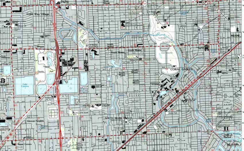
The site is The Underline within the Miami-Dade Metrorail right-of-way extending from
the Dadeland South Station northeast to the Brickell Station at the northern end. The
Dadeland South Station is located at 9150 Dadeland Boulevard, Miami, Florida. The
Brickell Station is located south of the Miami River at 1001 SW 1st Avenue, Miami,
Florida. The ten mile site includes the following Metrorail stations going south from the
Brickell Station: Vizcaya, Coconut Grove, Douglas Road, University, South Miami,
Dadeland South and Dadeland North. The site location is shown on Figure 1. The site
is located in the City of Miami, Miami-Dade County, Florida.
According to the Miami-Dade County Property Appraiser the site is owned by the Miami-
Dade Department of Transportation and Public Works.. Primary zoning for sections of
the site available from the Miami-Dade County Property Appraiser include: Special Use,
Commercial – Liberal, Industrial – General, Single Family, Community Facilities and
Intensive Use. Available Parcel Control Numbers for sections of the site include 01-
4115-000-0120; 01-4121-000-0140; 01-4116-000-0230; 03-4120-000-0031; 03-4120-
023-4200, 03-4119-004-3410; 09-4036-000-0260; 30-4035-000-1052. Copies of
available property information obtained from the Miami-Dade County Property
Appraiser’s office are included in Appendix A.
A street map identifying the site location is presented as Figure 1; Topographic maps
identifying sections of the site are presented as Figure 2A – 2C.
2.2 SITE AND VICINITY GENERAL CHARACTERISTICS
The site consists of 10 miles of The Underline within the Miami-Dade Metrorail right-of-
way extending from the Dadeland South Station northeast to the Brickell Station at the
north end. The site is located in a mixed-use area including residential and commercial
areas.
2-110 Mile Corridor Limited Phase I, Miami FL
Amec Foster Wheeler
Project Number 6783-16-2797
May 18, 2016
2.3 CURRENT USES OF THE ADJOINING PROPERTIES
Residential and commercial properties are located on the eastern and western portions
of the rail running north from SW 15th Road to the Brickell Station. US-1 Highway runs
adjacent and parallel generally along a majority of the southern portion of the rail running
northeast to southwest from the Vizcaya Station at SW 32nd Road to SW 90th Street. A
mix of residential, commercial properties and parks are located on both sides of the rail.
2-210 Mile Corridor Limited Phase I, Miami FL
Amec Foster Wheeler
Project Number 6783-16-2797
May 18, 2016
3.0 PHYSICAL SETTING
Amec Foster Wheeler staff reviewed reasonably ascertainable sources to assess the
physical setting of the site, including the topographic, geologic, hydrogeologic, and
hydrologic characteristics of the site. The results of our review are presented below.
3.1 TOPOGRAPHY
The 7.5-minute Miami, Key Biscayne and South Miami, Florida, United States Geological
Survey (USGS) quadrangle, published in 1994 were examined. Review of the
topographic maps indicates that the site elevation ranges from approximately 15 feet to
10 feet above mean sea level (msl). The topography of the area is generally flat with a
slight slope towards the south.
3.2 SOILS
The United States Department of Agriculture (USDA) Soils Conservation Service (SCS)
map showed one predominant soil type on the subject property. According to the Dade
County Area Soil Survey, Urban Land is described by the USDA as “built up areas and
nearly level to very steep, moderately well drained or well drained soils consisting of fill
material that is 8 to more than 80 inches deep over limestone bedrock. Urban land is
covered by streets, sidewalks, parking lots, buildings, and other structures that so
obscure the soils that identification of the soil series is not feasible.”
The USDA Soils Conservation Service (SCS) map showed one soil type on the subject property.
Depth to
Soil Unit Landform Typical Profile
Groundwater
Moderately well drained or well drained soils
Marine Approximately
15-Urban land consisting of fill material that is 8 to more
terraces 2 to 13 feet
than 80 inches deep over limestone bedrock
3-110 Mile Corridor Limited Phase I, Miami FL
Amec Foster Wheeler
Project Number 6783-16-2797
May 18, 2016
3.3 GROUNDWATER
The general direction of groundwater flow can be inferred from ground surface
elevations and surficial expression of groundwater identified on the Miami, Key
Biscayne, and South Miami, Florida USGS topographic quadrangles. Surficial
groundwater occurrences generally include permanent lakes, streams, and wetland
areas. Based on Amec Foster Wheeler staff’s review of topographic maps,
Hydrogeology of the Surficial Aquifer System, Dade County, Florida (USGS 1991) and
observations of the site vicinity, the groundwater flow direction was inferred to be
generally to the east and south east. Please note that the MDPROS does not plan to
use groundwater or have the users of the site come in contact with groundwater. As
such, investigations of groundwater impacts are limited for this assessment.
3-210 Mile Corridor Limited Phase I, Miami FL
Amec Foster Wheeler
Project Number 6783-16-2797
May 18, 2016
4.0 USER-PROVIDED INFORMATION
Because this Limited ESA is being performed for a project that does not include a
property transaction, user-provided information, that would be used only for a proposed
transaction, was not requested by Amec Foster Wheeler’s environmental professional
and such information was not provided to Amec Foster Wheeler’s environmental
professional for the assessment. MDPROS (the user) understands that the absence of
a property transaction makes the user information unnecessary and that the lack of such
information is a departure for strict adherence with the transaction aspects of the ASTM
standard.
4-110 Mile Corridor Limited Phase I, Miami FL
Amec Foster Wheeler
Project Number 6783-16-2797
May 18, 2016
5.0 ENVIRONMENTAL RECORDS REVIEW
This section presents the results from the environmental records review. Section 5.1
discusses results from the search of standard environmental databases. These records
were reviewed to assess potential environmental concerns for the site, and, when
applicable, surrounding properties. Section 5.2 discusses results from additional
environmental record sources that were reviewed for this Limited Phase I ESA.
5.1 STANDARD ENVIRONMENTAL RECORDS SOURCES
Amec Foster Wheeler staff reviewed the results of a search of standard environmental
records sources within 500 feet on each side of the site. EDR provided results of a
regulatory agency database search in their report dated March 16, 2016. The report
was reviewed for information pertaining to storage and/or reported releases of
hazardous substances and petroleum products on the site and on surrounding
properties that may affect the site. The EDR search report is included in Appendix B
dated March 16, 2016.
The database search information has been divided into four subcategories: federal
records, state and local records, tribal records, and EDR proprietary records. Table 1
lists the environmental databases and the number of facilities found within the search
distance of 500 feet on each side of the Metrorail for each standard environmental
database. Table 1 lists only those databases for which one or more facilities were found
within the search distance.
Table 1: Environmental Database Search Results
Search Distance Number of
Environmental List (feet) Facilities Listed
Federal Records
Comprehensive Environmental Response, 1
Compensation and Liability Information System
(CERCLIS)
Resource Conservation and Recovery Act – Large 500 3
quantity generators (RCRA-LQG)
Resource Conservation and Recovery Act - Small 500 34
quantity generators (RCRA-SQG)
Resource Conservation and Recovery Act - 500 36
Conditionally exempt small quantity generators
5-110 Mile Corridor Limited Phase I, Miami FL
Amec Foster Wheeler
Project Number 6783-16-2797
May 18, 2016
Search Distance Number of
Environmental List (feet) Facilities Listed
(RCRA-CESQG)
Resource Conservation and Recovery Act – (Non 500 24
Gen/NLR)
(SSTS) 500 4
ICIS 500 1
FINDS 500 133
ECHO 500 133
US Airs 500 5
State and Local Records
(FL SWF/LF) 500 5
FL UIC 500 138
Leaking Underground Storage Tanks (FL LUST) 500 39
FL Tanks 500 1
Registered Underground Storage Tank (FL UST) 500 134
FL LAST 500 1
FL AST 500 24
NY MANIFEST 500 1
FL SPILLS 500 5
FL PRIORITY CLEANERS 500 6
FL DRY CLEANERS 500 14
FL NPDES 500 13
FL AIRS 500 5
FL TIER 2 500 30
FL RESP PARTY 500 6
FL CLEANUP SITES 500 23
FL DWM CONTAM 500 22
EDR Proprietary Records
EDR Historical Auto Station 500 104
EDR Historical Cleaners 500 52
FL RGA LF 500 2
FL RGA LUST 500 60
5-210 Mile Corridor Limited Phase I, Miami FL
Amec Foster Wheeler
Project Number 6783-16-2797
May 18, 2016
Review of the federal, state, additional environmental records, and proprietary records
summary provided by EDR revealed 1059 listings for sites of environmental concern
located within a search distance of 500 feet on each side of the site. Because some
sites may occur on more than one database, the total number of listings may be greater
than the total number of applicable sites. Maps illustrating the locations of the listings
are included in Appendix C.
5.1.1 Federal Records
Based on distances from the site, the types of listings, and the assumed direction of
groundwater flow, the sites listed below may have a negative impact on the site and
should be considered for the design of the Phase II sampling and analysis investigation.
Mario’s Dry Cleaning Inc. (IW5-6175/File-5751/FDEP# 129) 5828 SE 71 St.
South Miami, FL 33143, located approximately 250 feet to the east of the
Metrorail at the South Miami Station was identified on the CERCLIS list.
According to information presented in the EDR Report and the Miami-Dade
County Department of Regulatory and Economic Resources (RER)
Database, the facility is an active dry cleaning facility permitted by the RER.
The facility was issued a Notice of Violation (NOV) by RER in 2011 for failing
facility site inspections and in 2012 for a chlorinated solvent discharge. The
facility at the request of RER submitted a Site Assessment Report (SAR)
dated July 30, 2012 prepared by Hydrologic Associates USA Inc. (HAI) that
documented the presence of chlorinated solvents in the groundwater at the
facility. A SAR Addendum (SARA) dated January 29, 2014 prepared by HAI
for the facility at the request of RER documented soil and groundwater
chlorinated solvent impact. The January 2014 SARA also indicated that the
groundwater flow in the vicinity of the facility is to the east, which would make
the facility downgradient from the underline/subject site. RER in a memo
dated March 18, 2014 requested additional site assessment to further
delineate the soil and groundwater chlorinated solvent impact at the facility.
The requested additional site assessment to delineate the impact is currently
pending. As such Mario’s Dry Cleaning Inc. is considered a REC at this time.
McDonald Imperial Cleaners (FDEP # 13 8629041) 5840 S Dixie Hwy South
Miami, Florida 33143 located approximately 200 feet southeast of the site
was identified on the RCRA-SQG, FINDS, FL LUST, FL UST, FL
DRYCLEANERS, FL PRIORITYCLEANERS, FL DWM CONTAM and
ECHO lists. A Florida Department of Environmental Protection (FDEP) letter
5-310 Mile Corridor Limited Phase I, Miami FL
Amec Foster Wheeler
Project Number 6783-16-2797
May 18, 2016
dated February 22, 2016 notified the property owner of available funding for a
site assessment. The McDonald Imperial Cleaners site is considered a REC
at this time due to a pending site assessment.
South Miami Radiator CO. (IW5-319/File 298) 6400 South Dixie Hwy, South
Miami, Florida located approximately 150 feet southeast of the site was
identified on the RCRA-SQG, FINDS and ECHO lists. According to DERM
records, South Miami Radiator CO. is required to monitor the groundwater
quarterly for lead related to a June 1994 violation. According to a DERM
memo dated July 24, 2015 a quarterly monitoring report is pending. The
South Miami Radiator CO. site is considered a REC at this time due to the
pending groundwater monitoring required to document to current lead
concentrations.
Florida Power & Light (FPL) (HWR-374/File-14971) 5235 Ponce De Leon
Blvd Coral Gables Florida 33134 located approximately 150 feet northwest of
the site was identified on the RCRA-CESQG, FINDS, Miami Dade Co. HWS
and ECHO lists. The FPL site also has a listed address of 5301 Ponce De
Leon Blvd Coral Gables Florida 33134. According to a quarterly status report
dated August 11, 2015 prepared by SCS Engineers, the FPL site has
documented Arsenic groundwater impact. A remedial system is currently in
operation to address the groundwater impact. The FPL site is considered a
REC at this time due to the Arsenic groundwater impact.
Sunset Quickprint (IW5-573/File 536) 5833 Ponce De Leon Blvd, Coral
Gables Florida, 33146 located approximately 100 feet northwest of the site
was identified on the RCRA-CESQG, FINDS, FL Enforcement and ECHO
lists. According to a DERM memo dated September 16, 2015, evidence of
unauthorized industrial waste discharges to an on-site septic tank were
observed by DERM personnel on March 5, 2015 during an inspection for the
facility. The Sunset Quickprint site is considered a REC at this time due to
the unauthorized discharge of industrial waste to an on-site septic tank.
Supershine Car Wash,FDEP # 13 8842244; DERM UT-1777/F-8113) 9790
South Dixie Highway, Miami, Florida located approximately 60 feet east of the
site was identified on the FL LUST list. According to a Pilot Test Plan dated
January 29, 2016 prepared by PI Environmental, the facility prior to operating
as car wash historically operated as a Fina Service Station retailing gasoline
products with last fuel sales around 1984. The UST's and dispenser islands
5-410 Mile Corridor Limited Phase I, Miami FL
Amec Foster Wheeler
Project Number 6783-16-2797
May 18, 2016
were removed in September 1994, and the underground piping was
abandoned in place. A discharge notification form was filed in November
1988. DERM approved a SAR on October 17, 2011. The SAR and
subsequent additional assessments documented groundwater petroleum
hydrocarbon impact at the facility. The Supershine Car Wash site is
considered a REC at this time due to the petroleum hydrocarbon groundwater
impact.
5.1.2 State and Local Records
Based on distances from the site, the types of listings, and the assumed direction of
groundwater flow, the following nearby sites are considered RECs.
Union 76 -17th Ave (FDEP # 13 8503538) 2465 SW 17th Ave, Miami, Florida
located approximately 70 feet northwest of the site was identified on the
LUST, UST, CLEANUP SITES and DWM CONTAM Lists. The facility is
currently operating as a Mobile Service Station. According to the EDR Report
and an April 2004 SSAR report prepared by ENSR, petroleum hydrocarbon
impact is present at the facility and remedial activities are ongoing. The
former Union 76 -17th Ave site is considered a REC at this time due to the
documented presence of petroleum hydrocarbon groundwater impact.
Grove Automotive (FDEP # 8504781) 3198 S. Dixie Hwy Miami Florida and
located approximately 100 feet south of the site was identified LUST, UST,
Miami Dade IW, Enforcement, CLEANUP SITES and DWM CONTAM Lists.
Grove Automotive is currently operating as a Chevron Service Station.
According to the EDR report and DERM records, documented petroleum
hydrocarbon impact is present at the facility and a RAP was approved by
DERM in July 1993 to address groundwater impact. The former Grove
Automotive site is considered a REC at this time due to the documented
presence of petroleum hydrocarbon groundwater impact.
7 Eleven Store #3760 (FDEP # 8520524) 3498 S Dixie Hwy Miami Florida,
located approximately 100 feet south of the site was identified on LUST, UST,
Enforcement, CLEANUP SITES and DWM CONTAM Lists. The 7 Eleven
Store #3760 is currently operating as a Chevron Service Station. According
to the EDR report and FDEP records, petroleum hydrocarbon impact is
present at the former 7 Eleven Store #3760 site and, as such, is considered a
REC.
5-510 Mile Corridor Limited Phase I, Miami FL
Amec Foster Wheeler
Project Number 6783-16-2797
May 18, 2016
DEEL Volvo (FDEP # 13 8504336) 3650 Bird Road, Miami Florida adjacent to
the north of the site was identified on the LUST, UST, CLEANUP SITES and
DWM CONTAM Lists. An FDEP letter dated January 14, 2016 notified the
property owner of available funding for a site assessment for documented
petroleum impact related to a July 1992 from discharge that is pending
assessment. The DEEL Volvo site is considered a REC at this time due to
the pending site assessment to characterize documented petroleum impact.
Sunshine #245 (FDEP # 8504023) 3010 SW 37th Ave Miami Florida located
approximately 300 feet northwest of the site was identified on the LUST,
UST, AST, CLEANUP SITES and DWM CONTAM Lists. The Sunshine #245
facility is currently operating as a WESTAR Service Station. According to the
EDR report and FDEP records, petroleum hydrocarbon impact is present at
the former Sunshine #245 site and as such is considered a REC.
Culligan Water Conditioning (FDEP # 8622130) 3510 S Dixie Hwy Miami
Florida located approximately 250 southeast was identified on the LUST,
UST, CLEANUP SITES and DWM CONTAM Lists. According to the EDR
report and FDEP records, petroleum hydrocarbon impact is present at the
Culligan Water Conditioning site and as such is considered a REC.
7 Eleven Store # 3759 (FDEP 8504440) 375 S Dixie Hwy Miami Florida
located adjacent to the southeast of the site was identified on LUST, UST,
Enforcement, CLEANUP SITES and DWM CONTAM Lists. The 7 Eleven
Store # 3759 is currently operating as a Mobil Service Station. According to
the EDR report and FDEP records, petroleum hydrocarbon impact is present
at the former 7 Eleven Store # 3759 site and as such is considered a REC.
University of Miami – Physics (FDEP 8942886) 1535 Levante Ave Coral
Gables Florida located approximately 400 feet northwest of the site was
identified on the LUST, UST, UIC, AST, Miami Dade IW, Enforcement,
Miami-Dade Co. AP CLEANUP SITES and DWM CONTAM Lists. According
to the EDR report and FDEP records, petroleum hydrocarbon impact is
present at the University of Miami – Physics site and as such is considered a
REC.
University Car Care (FDEP # 8506412) 1492 S Dixie Hwy, Coral Gables
Florida located approximately 150 feet southeast of the site was identified on
LUST, UST, AST, CLEANUP SITES and DWM CONTAM Lists. The
5-610 Mile Corridor Limited Phase I, Miami FL
Amec Foster Wheeler
Project Number 6783-16-2797
May 18, 2016
University Car Care facility is currently operating as a Shell Service Station.
According to the EDR report and FDEP records, petroleum hydrocarbon
impact is present at the former University Car Care site and as such is
considered a REC.
7 Eleven Store #3760 (FDEP# 8506411) 6790 SW 57th Ave South Miami
Florida located approximately 75 feet northwest of the site was identified on
LUST, UST, CLEANUP SITES and DWM CONTAM Lists. The 7 Eleven
Store #3760 is currently operating as a Mobil Service Station. According to
the EDR report and FDEP records, petroleum hydrocarbon impact is present
at the former 7 Eleven Store #3760 site and as such is considered a REC.
Sunshine #107/Amoco Service Station (FDEP # 13 8505925) 6350 S Dixie
Hwy South Miami, Florida located approximately 100 feet southeast of the
site was identified on the LUST, UST, Miami Dade IW, Enforcement, DWM
CONTAM, RCRA-SQG, FINDS and ECHO lists. The Sunshine #107/Amoco
Service Station is currently operated as a Marathon Service Station. An
FDEP letter dated September 28, 2015 notified the property owner of
available funding for a site assessment for documented petroleum impact
from August 1988 and September 1992 discharges that are pending
assessment. The Sunshine #107/Amoco Service Station site is considered a
REC at this time due to the pending site assessment to characterize
documented petroleum impact.
Sunshine # 252 (FDEP # 8505993) 8033 S Dixie Hwy, Miami, Florida located
approximately 140 feet southeast of the site was identified on LUST, UST,
Miami-Dade Co. HWS, Miami-Dade Co. SPILL, Enforcement, CLEANUP
SITES and DWM CONTAM Lists. The Sunshine # 252 is currently operating
as a Shell Service Station. According to the EDR report and FDEP records,
petroleum hydrocarbon impact is present at the former Sunshine # 252 site
and, as such, is considered a REC.
Auto Perfection (FDEP 8504810) 9180 S Dixie Hwy Miami Florida located
approximately 50 feet southeast of the site was identified on LUST, UST,
Miami-Dade Co. AP, Miami-Dade IW, Enforcement and CLEANUP SITES,
DWM CONTAM lists. According to the EDR report and FDEP records,
petroleum hydrocarbon impact is present at the Auto Perfection site and, as
such, is considered a REC.
5-710 Mile Corridor Limited Phase I, Miami FL
Amec Foster Wheeler
Project Number 6783-16-2797
May 18, 2016
5.1.3 EDR Proprietary Records
Based on distances from the site, the types of listings, and the assumed direction of
groundwater flow, none of the additional listings is likely to have a negative impact on
the subject property.
5-810 Mile Corridor Limited Phase I, Miami FL
Amec Foster Wheeler
Project Number 6783-16-2797
May 18, 2016
6.0 HISTORICAL RECORDS REVIEW
Amec Foster Wheeler staff reviewed reasonably ascertainable, standard historical
sources provided in EDR Radius Map with GeoCheck®, EDR, Inquiry Number
4558473.5s, dated March 16, 2016 to develop a history of the previous uses of the
surrounding areas in order to help identify the likelihood of past uses that could have led
to RECs in connection with the site.
6.1 AERIAL PHOTOGRAPHS
Aerial photographs were not reviewed for the Limited Phase I ESA.
6.2 HISTORICAL TOPOGRAPHIC MAPS
Historical topographic maps of the site and surrounding area were not reviewed for the
Limited Phase 1 ESA.
6.3 FIRE INSURANCE MAPS
Fire insurance maps were not reviewed for the site.
6.4 PREVIOUS REPORTS OR RECORDS OF PROCEEDINGS
Previous reports or records of proceedings for the site were not available for review.
6.5 HISTORICAL USE INFORMATION ON ADJOINING PROPERTIES
Amec Foster Wheeler staff obtained historical use information on several adjoining
properties in the process of researching the site, as described in the preceding sections.
Based on our review, historical records identify some adjacent sites that have the
likelihood of past uses that cause them to be considered as RECs in connection with the
site. The identified historical sites have been listed in the previous sections.
6-110 Mile Corridor Limited Phase I, Miami FL
Amec Foster Wheeler
Project Number 6783-16-2797
May 18, 2016
7.0 SITE RECONNAISSANCE
Mr. Jonathan Bulley of Amec Foster Wheeler completed the site reconnaissance on
March 31, 2016, observing general conditions of accessible areas of 10 miles of The
Underline within the Metrorail right-of-way extending from the south end at the Dadeland
South station northeast to the Brickell Station at the north end. Mr. Jonathan Bulley was
accompanied by Nelson Borgen of Amec Foster Wheeler during the site reconnaissance
on March 31, 2016. This section presents the findings of the site reconnaissance. These
observations pertain to the general conditions of the physical land, including location and
presence of ponded water, wetlands, stained and stressed vegetation, monitoring wells,
wastewater, and solid or liquid waste.
7.1 METHODOLOGY AND LIMITING CONDITIONS
A description of the subject property, as observed during the reconnaissance, is
provided in the following subsections. Photographs obtained during the reconnaissance
have been included in Appendix D.
7.2 GENERAL SITE SETTING
At the time of Amec Foster Wheeler staff’s site reconnaissance on March 31, 2016, the
subject property was observed as The Underline within the 10 mile stretch of the
Metrorail right-of-way extending from the south end at the Dadeland South Station
northeast to the Brickell Station at the north end. The Underline was covered by grass
or asphalt pavement.
No hazardous substance or petroleum products usage or on-site processes that use,
treat, store, dispose, or generate hazardous substances or petroleum products were
observed.
We did not observe roads or pathways with no apparent outlet that appeared to have
been used as an avenue for dumping of hazardous materials or petroleum products.
Some waste dumping was noted in a limited section north of the Vizcaya Station as
noted on Photo #8 in Appendix D.
7.3 ABOVEGROUND STORAGE TANKS
No ASTs or associated dispenser(s) and piping were observed on the site.
7-110 Mile Corridor Limited Phase I, Miami FL
Amec Foster Wheeler
Project Number 6783-16-2797
May 18, 2016
7.4 UNDERGROUND STORAGE TANKS
No USTs or associated dispenser(s) and piping were observed on the site.
7.5 ODORS
No unusual odors were noted at the site on the day of the site reconnaissance.
7.6 POOLS OF LIQUID
Standing surface water was not observed on the site during the site reconnaissance.
Pools, catchment structures, or sumps containing liquids or oily sheen likely to be
hazardous substances or petroleum products were not observed on the site during the
site reconnaissance.
7.7 PITS, PONDS, OR LAGOONS
No pits, ponds, or lagoons were observed at the site on the day of the site
reconnaissance.
7.8 DRUMS
No drums were observed on the site during the site reconnaissance.
7.9 HAZARDOUS SUBSTANCES AND PETROLEUM PRODUCTS STORAGE
CONTAINERS
No containers identified as containing hazardous substances or petroleum products
were observed on the site during the site reconnaissance.
7.10 UNIDENTIFIED SUBSTANCE CONTAINERS
No unidentified containers containing unidentified substances suspected of being
hazardous substances or petroleum products were observed on the site during the site
reconnaissance.
7-210 Mile Corridor Limited Phase I, Miami FL
Amec Foster Wheeler
Project Number 6783-16-2797
May 18, 2016
7.11 POLYCHLORINATED BIPHENYLS
Electrical transformers are a potential REC due to the potential presence of
polychlorinated biphenyls (PCBs) contained in dielectric fluids used in some units. Amec
Foster Wheeler staff did not observe any electrical or hydraulic equipment known to
contain PCBs or likely to contain PCBs on the site. PCBs were not included in
transformers when Metrorail was constructed.
7.12 STAINS OR CORROSION
No stains or corrosion indicative of hazardous substances or petroleum products were
observed on the site during the site reconnaissance.
7.13 DRAINS, SUMPS, OR OTHER DISCHARGE FEATURES
Several stormwater drains were observed at the subject property. The discharge point
of the drains was not verified. It is likely that the storm drains discharge directly to the
ground in the vicinity of the Metrorail.
7.14 STAINED SOIL/PAVEMENT OR STRESSED VEGETATION
No stained soil/pavement or stressed vegetation was observed at the subject property
during the site reconnaissance.
7.15 SOLID WASTE OR FILL DIRT
An area located approximately 570 feet north of the Vizcaya rail Station and
approximately 70 feet to the east of the Metrorail tracks was observed to the filled with
trash, debris or other solid waste during the site reconnaissance. See Photo #8 in
Appendix D.
7.16 WASTEWATER
No wastewater, leach fields, or sanitary discharges were observed on the site during the
site reconnaissance.
7.17 WELLS
No dry wells, irrigation wells, injection wells, abandoned wells, or monitoring wells were
observed at the subject property during the site reconnaissance.
7-310 Mile Corridor Limited Phase I, Miami FL
Amec Foster Wheeler
Project Number 6783-16-2797
May 18, 2016
7.18 SEPTIC SYSTEMS
No septic systems were observed on the site during the site reconnaissance.
7.19 WET AREAS OR SURFACE WATER BODIES
A detailed wetland evaluation is beyond the scope of this investigation. Areas that may
be wetlands or nearby surface water bodies were not observed on the site. There were
not obvious signs of filling of wetlands or discharges (e.g., oily sheen) to surface water
bodies.
7-410 Mile Corridor Limited Phase I, Miami FL
Amec Foster Wheeler
Project Number 6783-16-2797
May 18, 2016
8.0 INTERVIEWS
No interviews were conducted as part of the Limited Phase I ESA.
8-110 Mile Corridor Limited Phase I, Miami FL
Amec Foster Wheeler
Project Number 6783-16-2797
May 18, 2016
9.0 FINDINGS
Amec Foster Wheeler staff has performed this Limited Phase I ESA for the site identified
as The Underline within the Metrorail right-of-way extending from the Dadeland South
Station northeast to the Brickell Station at the northern end in Miami-Dade County,
Florida.
The following RECs and other environmental concerns were identified during the
completion of this Limited Phase I ESA:
An area located approximately 570 feet north of the Vizcaya Station and
approximately 70 feet to the east of the underline of the rail was observed to the
filled with trash, debris or other solid waste during the site reconnaissance and is
considered a REC.
Nineteen adjacent and surrounding properties along the site within 500 feet on
each side of the site with documented contaminants are considered RECs.
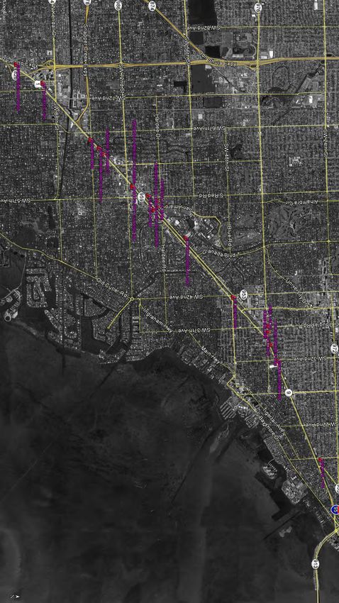
Figure 3 illustrates the adjacent and surrounding properties considered as RECs.
9-110 Mile Corridor Limited Phase I, Miami FL
Amec Foster Wheeler
Project Number 6783-16-2797
May 18, 2016
10.0 OPINION
Based on the opinion of the environmental professional, the site may be impacted by
contamination from adjacent and surrounding properties. The listed RECs should be
further evaluated and considered during the design of a Phase II sampling and analysis
plan for the site. It should be noted that the groundwater contamination concerns
associated with the RECs may not be of significant relevance for the proposed use of
the subject property since no groundwater use or likely groundwater contact is
anticipated.
10-110 Mile Corridor Limited Phase I, Miami FL
Amec Foster Wheeler
Project Number 6783-16-2797
May 18, 2016
11.0 CONCLUSIONS
Amec Foster Wheeler staff has performed a Limited Phase I ESA for the 10 mile long
site identified as The Underline within the Metrorail right-of-way extending from the
Dadeland South Station to the Brickell Station in Miami-Dade County, Florida. This
assessment has revealed the evidence of recognized environmental conditions in
connection with the site. The RECs are primarily associated with contaminated
groundwater, which may not present significant relevant issues based on the anticipated
non groundwater use of the subject site. The listed RECs will be used in the design of a
Phase II sampling and analysis plan for the site.
Should additional surface, subsurface, chemical, or other data become available after
the date of issue of this report, the findings, conclusions, and recommendations
contained herein may have to be modified.
11-110 Mile Corridor Limited Phase I, Miami FL
Amec Foster Wheeler
Project Number 6783-16-2797
May 18, 2016
12.0 REFERENCES
ASTM International (ASTM), 2013, ASTM E 1527-13, Standard Practice for Environmental
Site Assessments: Phase I Environmental Site Assessment Process, ASTM International,
West Conshohocken, Pennsylvania.
U.S. Geological Survey (USGS), Miami, Key Biscayne and South Miami Target Property
Quadrangle, 7.5-minute series (topographic) maps, dated 1994.
EDR Radius Map with GeoCheck®, EDR, Inquiry Number 4558473.5s, dated
March 16, 2016.
12-110 Mile Corridor Limited Phase I, Miami FL
Amec Foster Wheeler
Project Number 6783-16-2797
May 18, 2016
14.0 QUALIFICATIONS OF ENVIRONMENTAL PROFESSIONAL(S)
Resumes for the individuals acting as representatives of Amec Foster Wheeler involved
in preparing this report are included in Appendix J.
14-110 Mile Corridor Limited Phase I, Miami FL
Amec Foster Wheeler
Project Number 6783-16-2797
May 18, 2016
FIGURESSCALE : NOT TO SCALE
E
IL R
M DO
10 RI
R
CO
AMEC FOSTER WHEELER
ENVIRONMENT & INFRASTRUCTURE, INC.
5845 N.W. 158th STREET
MIAMI LAKES, FL 33014
TEL: (305) 826-5588
FAX: (305) 826-1799
AMECFW PROJECT #: 6783-16-2797
10 MILE CORRIDOR
SOUTH PORTION OF METRORAIL
MIAMI, FLORIDA
FIGURE 1
SITE VICINITY MAP
DRAWN BY: DATE:
NAB 04/07/16
CHECKED BY: SCALE:
JAB N.T.S.E
IL
M
10
F OR
O
N RID
O
TI OR
SEC C
0 1500 3000
LEGEND
GRAPHIC SCALE
(FEET)
SECTION OF 10 MILE CORRIDOR
REFERENCE
USGS - CHRISTIANSTED QUADRANGLE MAPS 2013
FIGURE 2a
MIAMI METRORAIL DADE COUNTY, MIAMI, FLORIDA
7.5 MINUTE SERIES (TOPOGRAPHIC)
AMEC FOSTER WHEELER
ENVIRONMENT & INFRASTRUCTURE, INC.
10 MILE CORRIDOR
5845 N.W. 158th STREET TOPOGRAPHIC AREA MAP REVISED BY: NAB
MIAMI LAKES, FL 33014
TEL: (305) 826-5588
(DOWNTOWN MIAMI QUAD.)
FAX: (305) 826-1799
DRAWN BY: NAB DATE: 04/08/16
MIAMI, FLORIDA CHECKED BY: JAB SCALE: AS SHOWN
AMECFW PROJECT #: 6783-16-2797OR
R RID
O
I LEC
0 M
O F1
ON
SE CTI
0 1500 3000
LEGEND
GRAPHIC SCALE
(FEET)
SECTION OF 10 MILE CORRIDOR
REFERENCE
USGS - CHRISTIANSTED QUADRANGLE MAPS 2013
FIGURE 2b
MIAMI METRORAIL DADE COUNTY, MIAMI, FLORIDA
7.5 MINUTE SERIES (TOPOGRAPHIC)
AMEC FOSTER WHEELER
ENVIRONMENT & INFRASTRUCTURE, INC.
10 MILE CORRIDOR
5845 N.W. 158th STREET TOPOGRAPHIC AREA MAP REVISED BY: NAB
MIAMI LAKES, FL 33014
TEL: (305) 826-5588
(KEY BISCAYNE QUAD.)
FAX: (305) 826-1799
DRAWN BY: NAB DATE: 04/08/16
MIAMI, FLORIDA CHECKED BY: JAB SCALE: AS SHOWN
AMECFW PROJECT #: 6783-16-2797R
DO
R RI
CO
E
IL
M
10
F
O
N
T IO
C
SE
0 1500 3000
LEGEND
GRAPHIC SCALE
(FEET)
SECTION OF 10 MILE CORRIDOR
REFERENCE
USGS - CHRISTIANSTED QUADRANGLE MAPS 2013
FIGURE 2c
MIAMI METRORAIL DADE COUNTY, MIAMI, FLORIDA
7.5 MINUTE SERIES (TOPOGRAPHIC)
AMEC FOSTER WHEELER
ENVIRONMENT & INFRASTRUCTURE, INC.
10 MILE CORRIDOR
5845 N.W. 158th STREET TOPOGRAPHIC AREA MAP REVISED BY: NAB
MIAMI LAKES, FL 33014
TEL: (305) 826-5588
(SOUTH MIAMI QUAD.)
FAX: (305) 826-1799
DRAWN BY: NAB DATE: 04/08/16
MIAMI, FLORIDA CHECKED BY: JAB SCALE: AS SHOWN
AMECFW PROJECT #: 6783-16-2797LEGEND:
RECONGNIZED ENVIRONMENTAL
! CONDITION (REC)
AMEC FOSTER WHEELER
ENVIRONMENT & INFRASTRUCTURE, INC.
5845 N.W. 158th STREET
MIAMI LAKES, FL 33014
TEL: (305) 826-5588
FAX: (305) 826-1799
AMECFW PROJECT #: 6783-16-2797
10 MILE CORRIDOR
SOUTH PORTION OF METRORAIL
MIAMI, FLORIDA
FIGURE 3
MAP OF SITES
CONSIDERED AS REC's
DRAWN BY: DATE:
NAB 04/07/16
CHECKED BY: SCALE:
JAB N.T.S.10 Mile Corridor Limited Phase I, Miami FL
Amec Foster Wheeler
Project Number 6783-16-2797
May 18, 2016
APPENDIX A
MIAMI DADE COUNTY
PROPERTY APPRAISER INFORMATION3/24/2016 Property Search Application - Miami-Dade County
Summary Report
Generated On : 3/24/2016
Property Information
Folio: 03-4120-023-4200
Property Address:
MIAMI-DADE COUNTY
Owner
MIAMI-DADE TRANSIT
701 NW 1 CT STE 1700
Mailing Address
MIAMI, FL 33136-3902
Primary Zone 8600 SPECIAL USE
9162 UTILITY : RAILROAD
Primary Land Use
ASSESSMENT
Beds / Baths / Half 0/0/0
Floors 0
Living Units 0
Actual Area 0 Sq.Ft
Living Area 0 Sq.Ft 2015 Aerial Photography
1000ft
Adjusted Area 0 Sq.Ft
Lot Size 183,272 Sq.Ft Taxable Value Information
Year Built 0 2015 2014 2013
County
Assessment Information
Exemption Value $1,557,812 $1,557,812
Year 2015 2014 2013
Taxable Value $0 $0
Land Value $1,557,812 $1,557,812
School Board
Building Value $0 $0
Exemption Value $1,557,812 $1,557,812
XF Value $0 $0
Taxable Value $0 $0
Market Value $1,557,812 $1,557,812
City
Assessed Value $1,557,812 $1,557,812
Exemption Value $1,557,812 $1,557,812
Taxable Value $0 $0
Benefits Information
Regional
Benefit Type 2015 2014 2013
Exemption Value $1,557,812 $1,557,812
County Exemption $1,557,812 $1,557,812
Taxable Value $0 $0
Note: Not all benefits are applicable to all Taxable Values (i.e. County, School
Board, City, Regional).
Sales Information
Short Legal Description Previous OR Book-
Price Qualification Description
Sale Page
20 54 41 4.207 AC M/L
10411- Sales which are disqualified as a result of
C GABLES RIVIERA SEC 2 04/01/1979 $0
0380 examination of the deed
PB 28-18
COMM AT X CENTERLINE OF RIVIERA
DR & PONCE DE LEON BLVD S 42 DEG
The Office of the Property Appraiser is continually editing and updating the tax roll. This website may not reflect the most current information on record. The Property
Appraiser and Miami-Dade County assumes no liability, see full disclaimer and User Agreement at http://www.miamidade.gov/info/disclaimer.asp
Version:You can also read