O Woodside, Usk - Monmouthshire County Council
←
→
Page content transcription
If your browser does not render page correctly, please read the page content below

Monmouthshire County Council

Flood and Water Management Act 2010

Section 19 Flood Investigation Report

        Woodside, Usk
            February 2020

    Skenfrith
    O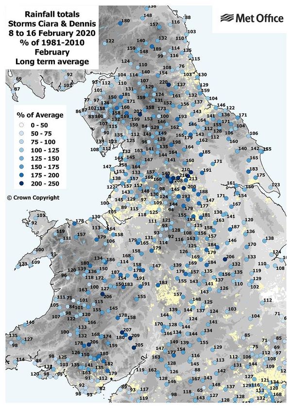
Flood and Water Management Act 2010
Section 19 Flood Investigation Report
Woodside, Usk, February 2020

Contents
Version Control .......................................................................................................................... 2
1.      Executive Summary............................................................................................................ 3
2.      Introduction ......................................................................................................................... 4
     2.1       Purpose of Investigation ............................................................................................. 4
     2.2       Site Location ................................................................................................................ 5
     2.3       Investigation Evidence ................................................................................................ 8
3. Flooding History ..................................................................................................................... 9
     3.1 Previous Flood Incidents .................................................................................................. 9
     3.2 Flood Incident ................................................................................................................. 11
     3.3 Rainfall Analysis ............................................................................................................. 16
4 Mechanisms of Flooding ....................................................................................................... 20
     4.1       Fluvial Flooding ......................................................................................................... 20
     4.2       Land Drainage ........................................................................................................... 20
     4.3       Surface Water Drainage............................................................................................ 21
     4.4       Foul Water Drainage ................................................................................................. 21
5       Rights and Responsibilities of Risk Management Authorities ......................................... 23
     5.1 Lead Local Flood Authority ............................................................................................ 23
     5.2 Natural Resources Wales .............................................................................................. 24
     5.3 Water / Sewerage Company .......................................................................................... 24
     5.4 Network Rail ................................................................................................................... 24
     5.5 Highway Authority .......................................................................................................... 24
     5.6 Riparian Landowners ..................................................................................................... 25
     5.7 Residents and Property Owners .................................................................................... 25
6       Permissive Powers of Risk Management Authorities ...................................................... 26
7       Flood Alleviation Scheme / Drainage Improvements ....................................................... 27
8       Conclusion ........................................................................................................................ 28
9       Recommendations ............................................................................................................ 29
10 Useful Links and Contacts................................................................................................ 30
Appendix A – Met Office Report ..................................................................................................
Appendix B – Land Drainage General Arrangement ..................................................................
Appendix C – Additional Photos of Flooding ...............................................................................

                                                                       1
Flood and Water Management Act 2010
Section 19 Flood Investigation Report
Woodside, Usk, February 2020

Version Control

 Title                   Woodside, Usk, February 2020

 Purpose                 Section 19 Flood Investigation Report

 Owner                   Highways and Flood Risk Management

 Approved by             M.Hand
                         (Head of Placemaking, Housing, Highways and Flooding)

 Date                    June 2021

 Version Number          Final

 Status                  Issued

 Review Frequency        N/A

 Next review date        N/A

                         Natural Resources Wales – May 2021
 Consultation
                         Dwr Cymru Welsh Water – May 2021

   Version      Prepared by         Reviewed by                 Approved by                 Date
    Final        D J Harris           R.Price                     M.Hand                  June 2021
                (Senior Engineer)   (Project Engineer)   (Head of Placemaking, Housing,
                                                            Highways and Flooding)

                                                   2
Flood and Water Management Act 2010
Section 19 Flood Investigation Report
Woodside, Usk, February 2020

1. Executive Summary
In accordance with Section 19 of the Flood and Water Management Act 2010 Monmouthshire
County Council (MCC) has a duty as Lead Local Flood Authority to investigate flooding within
its area, insofar as it considers it necessary or appropriate. This report has been prepared
specifically for the purpose of meeting the requirements of Section 19 and provides a factual
account of the flood event that occurred on 15th to 18th February 2020 at Woodside, Usk,
Monmouthshire.

On the 15 and 16th February 2020, a period of heavy rain fell on already wet ground resulting
in significant flooding in the town of Usk. This came from Storm Dennis and from Storm Ciara
which hit the area just a week before. Some areas received 50 to 100mm or more of rain
upon saturated ground, causing river levels to rise rapidly. The upper catchments of the River
Usk in the Brecon Beacons responded to the rainfall, resulting in a rapid rise in levels in the
river on Friday 15th and Saturday 16th February.

It has been established that the primary mechanisms of flooding were from the unnamed brook
that crosses the Woodside area and normally discharges into the River Usk at the northern
end of Usk Island. With the River Usk at a record level the brook could not discharge, known
as flood locking. Flooding of the local area commenced around 5.30pm on Friday 15 th
February. Water from the brook built up on the A472 highway that runs adjacent to the River
Usk and flowed down this road and then westerly through ground adjacent to the Glen Yr Afon
Hotel. Here it joined with out of bank flows emanating from an upstream section of the ordinary
watercourse flowing in a southerly direction towards and through Woodside Industrial Estate
and on to residential properties adjacent to Usk bridge and the local rugby club. Some
residential properties that lie between the River Usk and the A472 near the Usk bridge appear
to have flooded from their outfalls to the river, which may have occurred due to their flap valves
not closing properly. Flood water levels did not start to recede until the early hours of Monday
the 17th, a period of some 29 hours. Twelve residential and eight commercial premises had
internal and external flooding and a further five had flooding to gardens or working areas
causing damage to properties and disruption to residents and businesses. These figures are
based on reported data, it is possible that more properties and businesses were affected
considering the extent and depth of the flooding.

Following the flood event Officers from MCC’s Highways and Flood Risk Management Team
visited the locations affected by flooding and collated information of the event from residents
and landowners to gain an understanding of the nature of the flooding. Further detail has
been gathered from historic reports from previous flood events at the same location, and
information has been shared between MCC and Natural Resources Wales who are the Risk
Management Authority for the River Usk, which is designated as a main river. The Risk
Management Authority for the unnamed brook is MCC. Further invaluable information has
been gathered from residents and business owners through a letter drop and the helpful
responses.

The report has identified a number of recommendations and actions to avoid or minimise the
impact of any future flood events. These recommendations and actions can be found on
page 29.

                                                3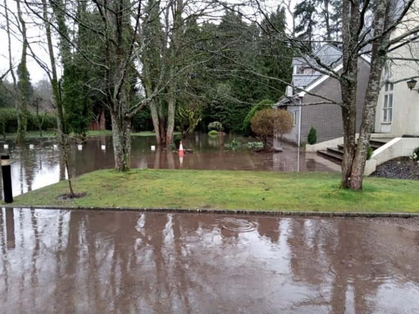
Flood and Water Management Act 2010
Section 19 Flood Investigation Report
Woodside, Usk, February 2020

2. Introduction
2.1 Purpose of Investigation
On 15th/16th February 2020 Monmouthshire was impacted by a significant weather event which
resulted in heavy and prolonged rainfall in the northern parts of the county and upper
catchments of many ordinary watercourses and main rivers, including the Rivers Usk, Monnow
and Wye.

The heavy rainfall event resulted in significant flooding in many areas across Monmouthshire,
notably Skenfrith, Abergavenny and Monmouth as well as the central part of the County, where
the town of Usk was badly affected, particularly the western side of the town and River Usk
known as Woodside. This report will focus on the flooding at Woodside, Usk.

The reason behind Monmouthshire County Council’s (MCC) investigation is in response to the
duties of the local authority in regards to Section 19 of the Flood and Water Management Act
2010, which states:

   (1) On becoming aware of a flood in its area, a Lead Local Flood Authority must, to the
       extent that it considers it necessary or appropriate, investigate:

       (a) Which risk management authorities have relevant flood risk management
           functions, and
       (b) Whether each of those risk management authorities has exercised, or is
           proposing to exercise, those functions in response to the flood.

   (2) Where an authority carries out an investigation under subsection (1) it must:

       (a) Publish the results of its investigation, and
       (b) Notify any relevant risk management authorities.

                                             4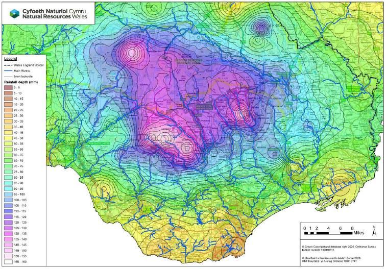
Flood and Water Management Act 2010
Section 19 Flood Investigation Report
Woodside, Usk, February 2020

2.2 Site Location
The historic town of Usk sits to the west of the County and takes its name from the River Usk
which flows from north to south on the west side of the town. It is a busy and popular town
with the A472 passing through west to east which then joins the A449 Trunk Road east of the
town and further west joins the A4042 Trunk Road. Its population in the 2011 census was
2,193. Woodside is a narrow area of land located on the west side of the River Usk adjacent
to Usk town.

Figure 1: Location Plan Showing the Flood Area (Indicative) and the Ordinary
Watercourse

The area of the investigation runs from the disused railway line in the north, to Kensington
Cottage in the south. The topography is relatively flat with a shallow gradient to the south
following the fall of the River Usk. To the west the ground rises quite steeply to Graig Foel
and Coed-duon hill. The River Usk flows from north to south through Usk town and separates
Woodside from the main town.

The source of River Usk lies in the west of the Brecon Beacons near Llanddeusant in Powys
on the northern slopes of the Black Mountain and traverses east to Brecon then southeast to
Abergavenny before heading south to discharge into the Severn Estuary at Newport. There
are four potential sources of flooding to Woodside; these are from the River Usk, the Berthin
Brook which lies to the northwest of Woodside, groundwater in the low lying areas and from a
small unnamed stream that flows from west to east through Woodside. The River Usk and
Berthin Brook are classed as main rivers and therefore Natural Resources Wales (previously
Environment Agency Wales) has permissive powers to manage flood risk from these
watercourses.

                                             5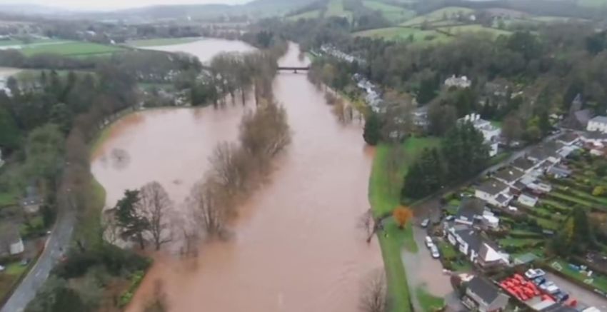
Flood and Water Management Act 2010
Section 19 Flood Investigation Report
Woodside, Usk, February 2020

Figure 2: Catchment of the River Usk at Woodside, Usk

The unnamed ordinary watercourses are the responsibility of Riparian owners. As a Risk
Management Authority, Monmouthshire County Council has permissive powers to undertake
work for the purpose of managing flood risk if deemed necessary. Natural Resources Wales
have previously carried out studies into flood risk from the local main rivers i.e. the River Usk
and Berthin Brook. There have been no reports or evidence that flooding on the Berthin Brook
affects Woodside. Road levels have a drop of around two metres in the area north of the old
railway embankment and is therefore likely to deflect runoff to the east, rather than south along
the road. The old railway embankment acts as a defence from flows from the north, apart for
the gap where the A472 road passes through.

There are a variety of residential properties in Woodside ranging from large houses to small
terrace houses; there is also a hotel, an office, a small industrial area known as the old goods
yard adjacent to the disused railway. South of the River Usk bridge, there is an large industrial
estate, a rugby ground and a garage, as well as a few residential properties. The A472 main
road also runs parallel to the River Usk through Woodside and is the main route between
Pontypool and Usk.

                                               6
Flood and Water Management Act 2010
Section 19 Flood Investigation Report
Woodside, Usk, February 2020

    Photo 1: Flooding of Road Outside Nos 11-15 Woodside Taken 16th Feb 2020
    Courtesy of a Local Resident.

Woodside is defended from flooding from the River Usk by raised defences which afford
protection against a 1.0% (1 in 100) annual chance event and which were constructed in the
late 1980s. The risk of flooding from the Berthin Brook is considered low. The threshold at
which flooding from the Berthin Brook is initiated is at least the 2% (1 in 50) annual chance
event and significant overland flow paths would have to be developed before Woodside is
threatened from the Berthin Brook.

Photo 2: A view of the flooding in the low lying are to the rear of the Glen Yr Afon

                                             7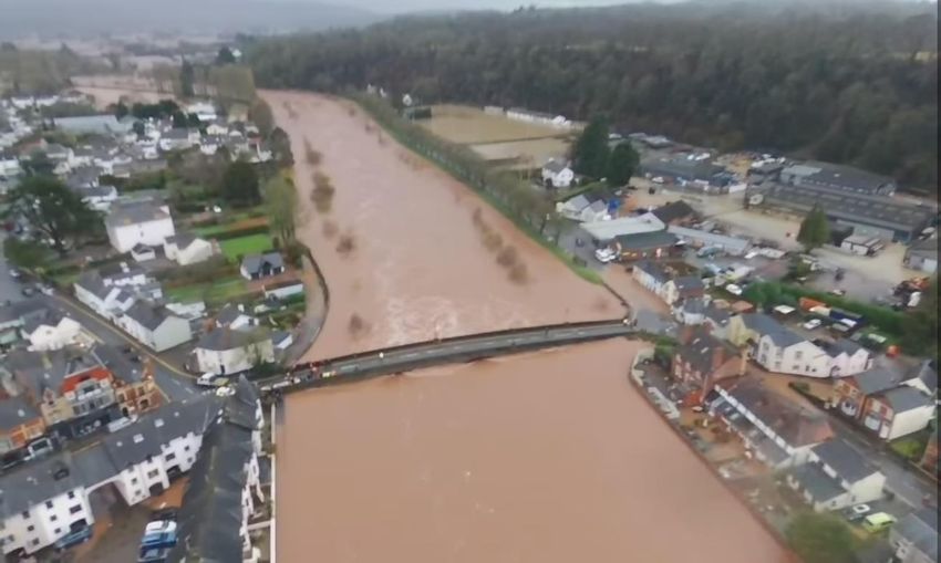
Flood and Water Management Act 2010
Section 19 Flood Investigation Report
Woodside, Usk, February 2020
The principal flood risk to Woodside is from the unnamed stream. Flood levels above the 50%
(1 in 2) annual chance event in the River Usk prevent the discharge of the unnamed stream
into the main river channel. Flood waters spill from the stream threatening the community.
The flow from the unnamed watercourse discharges into the River Usk via a 900mm diameter
culvert under the defences at the north end of the area known as the Island which has an
invert level of 16.00 metres AOD. This equates to a water level of 3.685 metres on the Usk
river gauge.
There are also potential issues with ground water flooding. A back-analysis of a previous flood
event carried out by W S Atkins suggests that the volumes of floodwater emanating from the
unnamed stream are insufficient to generate the recorded flood depths.
2.3 Investigation Evidence
To support the investigation a range of qualitative and quantitative evidence has been
gathered from numerous sources, the summary of which is listed below:
Residents – photos, statements, written correspondence
Surveys – drainage surveys and site inspections
Met Office Data – Weather warnings and reviews
Natural Resources Wales – river gauge data
Natural Resources Wales – rain gauges
Dwr Cymru Welsh Water (DCWW) records and information
Monmouthshire County Council – rain gauges, asset database & Flood Risk
Management Plan
Historic reports relating to flooding at Woodside, Usk, namely:
- “Pre Feasibility Report, Woodside, Usk, MCC, 2004
- “Flooding at Woodside” 2006, WS Atkins on behalf of MCC
8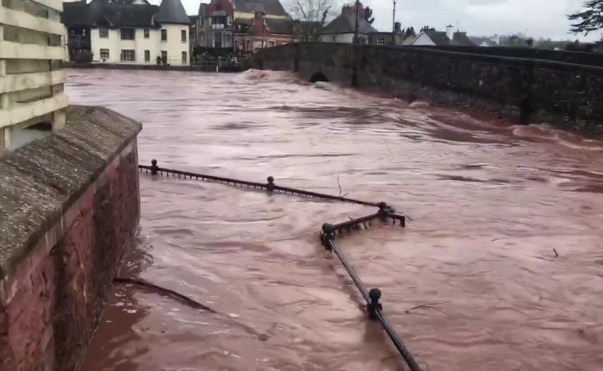
Flood and Water Management Act 2010
Section 19 Flood Investigation Report
Woodside, Usk, February 2020

3. Flooding History
3.1 Previous Flood Incidents
There is a long history of flooding at Usk including Woodside which occurred before the current
flood defences were constructed in the late 1980s.

In December 1979, the River Usk broke its banks in many locations in Monmouthshire and
caused significant flooding to both Usk town and Woodside. Following this event, a series of
defences were constructed by Natural Resources Wales’ predecessor organisations to
improve the flood protection to the area. In Woodside, the defences comprise a raised
embankment along the west bank of the River Usk and a section of wall north and south of
the bridge, then a further section of embankment south to higher ground near Llanbadoc.
Since these improvement works have been carried out, Woodside has not flooded directly
from the River Usk.

On the east bank there are bunds running from Abergavenny Road to downstream of the
Cricket club, with a wall immediately upstream of the river bridge, adjacent to the Police Station
on the downstream side and then a wall at Llanthowell.

Since the 1980’s there have been a number of flooding incidents in Woodside area, these
include;
 • October 1998,
 • October 2000, and
 • February 2002.

Photo 3: Flooding at the Glen Yr Afon Hotel in 2002, courtesy of John Tallet of Usk

                                                9
Flood and Water Management Act 2010
Section 19 Flood Investigation Report
Woodside, Usk, February 2020
The source of flooding during Storm Dennis was not from the River Usk but from the unnamed
stream that discharges into the River Usk. The unnamed stream flows in an open channel
from west to east through Woodside. The lower section is culverted under the A472 main
road and from here flows through a short stretch of open channel before entering another
culvert which cuts its way through and under the Usk flood defence embankment and beneath
the Usk Island recreation ground before entering the River Usk. A substantial flap valve is
housed on the outfall of the culvert in order to prevent ingress of the water from the Usk.
However, when there is a storm on the Usk and the flood levels exceed the soffit level of the
outfall this causes a “flood lock” situation preventing discharge into the Usk. As a result of this
the water backs up the culvert and the unnamed stream and overtops its banks causing
flooding to the area of Woodside.
The most recent event occurred on 16th February 2020 when the River Usk reached its highest
ever recorded level of 18.112 metres Ordnance Datum (OD). This created a flood lock period
of around 29 hours during which many residential and industrial properties were flooded
internally and or externally. Flood locking commences at around 16.0 metres OD, equivalent
to 3.685 metres on the River Usk gauge and full flooding comes into effect at 16.9 metres
equivalent to a gauge level of 4.585 metres, which is the top of the culvert pipe at the outfall.
The River Usk flood on the 16th February reached a peak of 5.8 metres gauge level equivalent
to 18.112 OD. Section 3.2 below provides more details of the event covered by this report.
Photo 4: Flooding of the Playing Field at Usk in 2002, Courtesy of John Tallet of Usk
10Flood and Water Management Act 2010
Section 19 Flood Investigation Report
Woodside, Usk, February 2020
3.2 Flood Incident
On the morning of 15th February 2020 the Met Office issued a Yellow Warning for heavy rain
for most of Wales with an Amber warning covering parts of south Wales and the western edge
of Monmouthshire. Heavy and persistent rain fell across much of south Wales during Saturday
15th February and overnight into Sunday as part of Storm Dennis.
Following this persistent period of heavy rain, levels in the River Usk rose rapidly during
Saturday and increased significantly overnight and during Sunday morning. The River Usk
reached its peak around 2.00pm on the Sunday and then steadily fell back to a more normal
level on Monday the 17th. Partial flood locking on the unnamed stream commenced around
8.30pm on Friday the 15th with full flood locking some four hours later. This continued through
to around 2.30am on the 17th and then became fully open for discharge by 5am on Monday
the 17th. This created a flood lock period of some 27 to 35 hours.
Figure 3: The Flood Levels in the River Usk 15th to 18th February 2020
As flows in the unnamed stream ceased to discharge to the river the A472 began to flood with
some flows moving south down the road towards the Usk Bridge. Some flows went off to the
west in a low area just north of the Glen Yr Afon Hotel. These flows then continued on to flood
the lower lying areas west of the properties and then further south to the industrial area.
Residential properties at Woodside Court and Mayfield were flooded internally and two
properties were surrounded by floodwater about 200mm deep. One of these properties
avoided internal flooding by pumping via the Fire Service. Three properties had internal
flooding in the Woodside Court area and three others had flooded gardens or were surrounded
by flood water. Two commercial properties at the Old Goods Yard site were also surrounded
by flood water around 300mm deep.
11Flood and Water Management Act 2010
Section 19 Flood Investigation Report
Woodside, Usk, February 2020
Figure 4: Plan Showing Indicative Flow Paths and Flood Extents
Natural Resources Wales issued a statement over the weekend of the flood as follows:
“The impact of two weekend of storms - Ciara and Dennis - on people and property has been
felt across the whole of Wales, and our thoughts are with all those affected. Only a week on
from Storm Ciara flooding communities across Wales, we saw exceptional rainfall and river
levels during Storm Dennis over the weekend of 15-16 February. Many rivers have reached
record levels, properties have been flooded and, in some communities, people were
evacuated from their homes. The impacts have been significant, on people, property,
businesses and livelihoods. These are the biggest floods for years in these areas, and
communities will be affected for months to come”.
The kitchen area of the Glen Yr Afon Hotel, which is at the rear of hotel the was reported to
have been flooded from the lower lying land at the rear as were some of the terraced houses
on the west side of the A472 north the Usk bridge. A number of residential properties on the
east side of the A472 near the bridge were also affected and these may have been flooded
from their outfalls to the river, possibly due to flap valves being lifted by flood waters in the
River Usk, (See Photo 9 below). Water also flowed through the masonry wall at the south
west side of the bridge where there are visible cracks in a short length of the wall here, (See
Photo 6 below). It is possible these cracks were there prior to the flood, as these walls have
been subject to traffic damage from large vehicles.
12Flood and Water Management Act 2010
Section 19 Flood Investigation Report
Woodside, Usk, February 2020
Photo 5: Flooding at the Rear of the Glen Yr Afon Hotel
Residents of the cottages just south of the bridge were badly affected by the water seeping
through the bridge wall at the front to around 200mm and by much deeper water at the rear
and commented that flooding commenced around 7am on the 16th and rose very quickly during
the morning to around one metre deep internally.
Photo 6: Water Flowing through Usk Bridge Parapet Wall - West Side.
13Flood and Water Management Act 2010
Section 19 Flood Investigation Report
Woodside, Usk, February 2020
Photos 7 and 8: Showing Internal Flooding to Cottages South of the Bridge, Courtesy
of Local Residents
Highway gullies were also notably full of debris and this would have delayed the flood waters
clearing. It is unclear whether they were silted up from the flood or previously but the flood
generated a great deal of debris.
The rugby field and its pavilion buildings were badly affected with water up to the serving bars,
several feet deep in the pavilion. It is noticeable that the A472 falls as it travels south from the
Old Goods Yard to the bridge and continues on the minor road, R106, to the rugby pitch by
some two metres which would have hampered clearing the flood water once the flood locking
cleared. This also partly accounts for the deeper flood water at the southern part of the
Woodside area.
Photo 9: Example of Outfall with Flap Valve, taken July 2020
14Flood and Water Management Act 2010
Section 19 Flood Investigation Report
Woodside, Usk, February 2020
Photos 10 & 11: Flooding at the Rugby Club, taken on Sunday 17th
In addition to providing support through the provision of sandbags during the event, Officers
from MCC were on site to assist residents and record details of the flooding on Sunday 17th
and again on Monday the 18th February.
Flood waters receded steadily on the Monday once the river levels had dropped and the
unnamed brook could again discharge to the river. It left significant damage in its wake and
much clearing of mud and silt was required along with the need to pump out some properties.
One property that was not flooded internally but surrounded by floodwater has discovered
problems related to the flooding some five months later with floor tiles lifting and other defects
arising.
15Flood and Water Management Act 2010
Section 19 Flood Investigation Report
Woodside, Usk, February 2020
3.3 Rainfall Analysis
A Met Office review of the wet period in January and February 2020 (Appendix A)
reported a slow moving weather front that brought persistent rainfall across England
and Wales on 15th and 16th February
Figure 5: Met Office Rainfall Data December 2019 to February 2020. This also shows
daily rainfall totals through February 2020, with particularly wet days from Ciara (8th),
Dennis (15th) and Jorge (28th).
Storm Ciara and the week preceding Storm Dennis
Storm Ciara (8th and 9th February) impacted the catchments of North Wales most
severely. However, significant rainfall was also recorded in South Wales, particularly
on the uplands of the Brecon Beacons and Black Mountains, both of which are within
the catchment of the River Usk. The Tal y Maes rainfall gauge in the Black Mountains
recorded 38 mm of rainfall between 20:00 on 8th February and 16:15 on 9th February.
Further smaller rainfall events continued in the week preceding Storm Dennis,
including a rainfall of 31 mm on 13th February. In the seven days prior to Storm Dennis
the gauge at Tal y Maes recorded 93 mm of rain. A similar rainfall pattern was
observed elsewhere in the upper catchment of the Usk but with even higher amounts
of rainfall. The rainfall gauge at Crai Reservoir recorded 174 mm over the seven days
prior to Storm Dennis.
16Flood and Water Management Act 2010
Section 19 Flood Investigation Report
Woodside, Usk, February 2020
Storm Dennis
Storm Dennis was the fourth named storm of the 2019/2020 season and occurred only
a week after the heavy rainfall from Storm Ciara. Storm Dennis brought strong winds
and heavy rain across the UK from 15th February to 17th February
Weather impacts from Storm Jorge were in general less severe than from storms Ciara
and Dennis, but flooding problems continued in the aftermath of these earlier storms
and as a result of further rain falling on already saturated ground. The railway line
between Cardiff and Swansea was closed and there were reports of further localised
flooding. The M4 in west Wales was closed due to strong winds. Flooding problems
from the exceptionally wet February continued across all parts of the UK.
Figure 6: Rainfall Isohyet Map showing rainfall over a 48-hour period during Storm Ciara
(produced by NRW).
17Flood and Water Management Act 2010
Section 19 Flood Investigation Report
Woodside, Usk, February 2020
Date Rainfall at Tal y Maes (mm)
8th February (Storm Ciara) 6
9th February (Storm Ciara) 33
10th February 13
11th February 1
12th February 8
13th February 31
14th February 2
15th February (Storm Dennis) 55
16th February (Storm Dennis) 29
Total (8th to 16th February) 177
Table 1: Daily rainfall totals for the nine days up to and including 16th February 2020.
Figure 7: Rainfall Isohyet Map showing rainfall over a 48-hour period during Storm
Dennis in South Wales (produced by NRW).
From a local rain gauge at Estavarney near Monkswood, the total rainfall in the Usk
area was 97 mm in the 48-hour period up to 9am on Saturday the 16th February.
18Flood and Water Management Act 2010
Section 19 Flood Investigation Report
Woodside, Usk, February 2020
Figure 8: Rainfall Data for February 2020
19Flood and Water Management Act 2010
Section 19 Flood Investigation Report
Woodside, Usk, February 2020
4 Mechanisms of Flooding
4.1 Fluvial Flooding
The flooding mechanisms at Usk are well known with the main river defences protecting the
town and Woodside from flooding from the River Usk which is understood to be defended to
a 1:100 standard.
The unnamed brook that crosses through Woodside draws its flows from the hills behind, then
flows across the Woodside area, crosses under the A472 highway in a culvert, then into a
short section of open channel and then is culverted through the NRW maintained river Usk
defences. This section, with a 900mm diameter pipe, then discharges into the river. Generally,
the River Usk levels rise from rainfall in its main catchment in the Brecon Beacons and by the
time the peak flow reaches Usk town the local rainfall will have cleared. On this occasion as
in 2002, with such a wet period and a second storm within a week, both the flood peak on the
River Usk and local run off coincided and created significant flooding.
Once flood locking takes effect the highway and adjacent properties begin to flood, floodwater
flows south along the A472 as both highway and ground levels fall in that direction. There is a
low lying area just north of the Glen Yr Afon and flood water passes west through here to lower
lying land along the base of the hills, knowns as Graig Yn Allt. From here water levels build
up as well as flowing further south to flood the industrial area and the rugby field and pavilion.
As all outfalls become flood locked, flood water rises and continues until the River Usk falls
sufficiently to permit outfalls to clear the flood water. Photos 14-16 in Appendix B show the
difference in water colour from the two flood sources, with the lighter colour being from the
ordinary watercourse, the darker from the River Usk.
4.2 Land Drainage
Photo 12: The Open Ditch on the Industrial Estate taken July 2020
20Flood and Water Management Act 2010
Section 19 Flood Investigation Report
Woodside, Usk, February 2020
There is a very limited system of land drainage with the brook, and one notable open ditch in
the centre of the industrial area. Parts of the unnamed brook were noted to have quite an
amount of debris and silt when visited in June 2020, this may well be from the February floods.
Land owners will be notified to clear their sections of the brook to maintain an unobstructed
water course.
4.3 Surface Water Drainage
Within the Woodside area there is a system of highway drainage where individual or groups
of highway gullies collect highway run off and discharge via outfalls that pass through the flood
defences. Each of the outfalls have their own flap valves to prevent backflows during floods
on the River Usk. Responsibility for the highway gullies rests with MCC Highways department.
Similar to the unnamed brook these also become flood locked when the River Usk is in flood.
There are also several private outfalls from some of the households that sit between the A472
and the River Usk and again these outfalls become flood locked in flood situations. There are
also a number of private outfalls from the industrial area which again become flood locked at
flood periods. It is understood that the flap valves on the outfalls are maintained by Natural
Resources Wales as these were modified as part of the flood defence works in the late 1980s.
Responsibility for the connecting pipework rests with the asset owners.
The detail of the land drainage and surface water systems was collected following the flood
event through site investigations. This detail has been recorded on MCC’s flood and drainage
asset database in accordance with our duties as Lead Local Flood Authority. Additional
surveys have been completed as some information was not collected at the time of the initial
investigation due to water levels within the system.
4.4 Foul Water Drainage
Many properties at Woodside north of the bridge have their own sewage systems with septic
tanks, cesspits or other forms of private sewage treatment systems.
Figure 9: Indicative locations of Foul Sewerage Systems at Woodside
21Flood and Water Management Act 2010
Section 19 Flood Investigation Report
Woodside, Usk, February 2020
West of the bridge there is a short sewerage system along the rear of the cottages at numbers
11 to 21 Woodside which was overwhelmed by the flood waters. This would have mixed foul
sewage with flood water and some residents have reported that floodwater came up through
their sinks and bathrooms. North of the bridge and east of the A472 there is also a short
sewerage system for numbers 22, 24, 26, 28, 30 & 32 Woodside and both systems discharge
to the River Usk.
22Flood and Water Management Act 2010
Section 19 Flood Investigation Report
Woodside, Usk, February 2020
5 Rights and Responsibilities of
Risk Management Authorities
5.1 Lead Local Flood Authority
Under the Flood and Water Management Act 2010, Monmouthshire County Council (MCC)
has been established as the Lead Local Flood Risk Authority (LLFA) for its administrative area.
As defined in the Flood and Water Management Act 2010, MCC is responsible for ‘Managing’
what is termed, its ‘local flood risk’. This includes the risk of flooding from ordinary
watercourses, surface runoff and groundwater.
Local Authorities have always had certain responsibilities in relation to ordinary watercourses,
and in practice most Local Authorities took the lead in dealing with surface water flooding
incidents prior to the changes contained within the Flood and Water Management 2010.
The Flood and Water Management Act 2010 places a number of statutory duties on Local
Authorities in their new role as LLFAs including:
The preparation of local flood risk management strategies;
A duty to comply with the National Strategy;
To co-operate with other authorities, including sharing data;
A duty to investigate all flooding within its area, insofar as a LLFA consider it necessary
or appropriate;
A duty to maintain a register of structures and features likely to affect flood risk;
A duty to contribute to sustainable development; and
Consenting powers on ordinary watercourses.
In addition to these each LLFA has a number of what are called permissive powers. These
are powers that allow them to do something, but do not compel them to and include:
Powers to request information;
Powers to designate certain structures or features that affect flood or coastal erosion
risk;
The expansion of powers to undertake works to include broader risk management
actions; and
The ability to cause flooding or coastal erosion under certain conditions.
LLFA’s in Wales have also taken on the role of the SuDS Adopting and Approving Body in
relation to sustainable drainage systems as of the 7th January 2019. In this role they are
responsible for both approving the original design of the SuDS and adopting and maintaining
the finished system in accordance with Welsh Government’s National Standards for
Sustainable Drainage.
The function of the LLFA during and after the flooding at Woodside included a range of
Response and Recovery functions:
Officers investigated the initial flooding and have produced this report in line with
Section 19 FWMA 2010.
Officers contacted residents affected by flooding to offer support and advice to assist
in the recovery following the event.
Officers coordinated the response to the flooding with Emergency Services
23Flood and Water Management Act 2010
Section 19 Flood Investigation Report
Woodside, Usk, February 2020
Asset information collected during the flood event has been incorporated into the
LLFA Asset Register.
5.2 Natural Resources Wales
Under the Flood and Water Management Act 2010 and the Water Resources Act 1991, NRW
has discretionary powers to manage the risk of flooding from main rivers and the sea. They
are also recognised as a coastal erosion risk management authority under the Coastal
Protection Act 1949.
Their strategic oversight role is about having a Wales-wide understanding of all sources of
flooding, coastal erosion and the risks associated with them, on a consistent basis across
Wales to help inform the RMAs and the public.
Where present, NRW manage Internal Drainage Districts (IDDs) and are responsible for
maintenance, improvement and operation of drainage systems and regulation of watercourses
within the internal drainage district. Their main role is the close management of water levels
in watercourses or underground (groundwater) for the purpose of reducing the risk from
flooding and for sustaining all land uses and the environment.
5.3 Water / Sewerage Company
Sewerage Undertakers are responsible for maintaining the public sewerage systems,
including adopted sewers carrying surface water run-off.
In flood conditions, the sewer systems can often become overloaded with a mixture of
floodwater and sewage leading to overflow and flooding. Where applicable, Sewerage
Undertakers are responsible for the removal of surface water from impermeable surfaces
through their sewerage system. Where there is frequent and severe sewer flooding, Sewerage
Undertakers are required to address this through their capital investment plans which are
regulated by Ofwat. To prevent further flooding, water and sewer companies have a
responsibility to: monitor the levels; prevent overloading sewer systems; maintain and repair
drainage pipes as necessary. This investigation has not identified any assets or infrastructure
belonging to a water or sewage company that may have contributed to the flood event
5.4 Network Rail
Network Rail has an operational responsibility as a riparian owner and is required to undertake
regular maintenance of all assets that pose a risk to flooding. This investigation has not
identified any assets or infrastructure belonging to Network Rail that may have contributed to
the flood event.
5.5 Highway Authority
The Highway Authority is responsible for ensuring the highway is clear of obstructions and has
a drainage system that controls the surface water that falls onto the highway.
Monmouthshire County Council is the Highway Authority for all highways in Monmouthshire
apart from Trunk Roads which are managed by the Welsh Government. Highways Authorities
24Flood and Water Management Act 2010
Section 19 Flood Investigation Report
Woodside, Usk, February 2020
are also Risk Management Authorities in their own right according to the Flood and Water
Management Act 2010 and must adhere to all the responsibilities of Risk Management
Authorities.
Under the Highways Act 1980, the Highways Authority has a duty to maintain the highway.
This includes ensuring that highway surface water drainage systems are clear and free from
blockages.
5.6 Riparian Landowners
A riparian owner possesses rights over and responsibilities for the stretch of a watercourse
that forms the boundary of their property. A riparian owner is anyone who owns a property
where there is a watercourse within or adjacent to the boundaries of their property. A
watercourse includes a river, stream or ditch. Riparian owners, (householders and
businesses) are responsible for maintaining their rivers, streams, ditches, pipes, culverts and
bridges.
Riparian Landowners are legally responsible under common law for the maintenance of the
land generally up to the centreline of any watercourse adjacent to their property. This includes
the maintenance of the bed, banks and any boundary features e.g. vegetated strips such as
hedging, with routine clearance of debris and/or blockages.
This does not mean that the owner must remove all debris from the watercourse, but it does
require the owner to maintain as far as it does not pose a risk or ‘nuisance’ to a neighbour.
Any works to modify the watercourse by the landowner must first be passed through the
relevant Risk Management Authority, Lead Local Flood Authority (LLFA) or Natural Resources
Wales (NRW).
Landowners are responsible for ditches and land drainage assets upon their land at Woodside,
Usk, with permissive powers for those watercourses classified as Main Rivers falling to NRW
and all other watercourses to MCC.
5.7 Residents and Property Owners
Residents and property owners are responsible for the maintenance and operation of drainage
assets and connecting pipework falling within their ownership. They are also responsible for
the protection of their own properties against flooding. Where safe to do so, they should take
measures to protect themselves and their property from flooding. Residents and property
owners have the right to defend their property as long as they do not subsequently increase
the risk of flooding to other properties.
25Flood and Water Management Act 2010
Section 19 Flood Investigation Report
Woodside, Usk, February 2020
6 Permissive Powers of Risk
Management Authorities
As Risk Management Authority for the main River Usk, Natural Resources Wales have
permissive powers under the Flood and Water Management Act 2010 and Water Resources
Act 1991. These discretionary powers include the ability to undertake works to clear
watercourses, as well as promoting and implementing flood alleviation schemes when
justifiable.
MCC also have similar permissive powers under the Land Drainage Act 1991 on ordinary
watercourses and drainage features. Monmouthshire CC is also the Lead Local Flood
Authority and the investigating and reporting body for flood events in the County. As Highway
Authority, MCC arranged clearance of the highway drainage systems following the flood event
and recorded the detail on their drainage asset database in accordance with their duties as
Lead Local Flood Authority.
26Flood and Water Management Act 2010
Section 19 Flood Investigation Report
Woodside, Usk, February 2020
7 Flood Alleviation Scheme /
Drainage Improvements
Following the flooding in 2002 W S Atkins were asked to produce a Project Appraisal that
would identify possible options to reduce flood risk, identify those that could be progressed
and recommend a solution. The following options were identified:
Option Details
A Do nothing – the base option
B Do-Minimum
C Weir structure, collecting channel and pumping station in the long meadow
D Overflow and Pumping station adjacent to Island House and Pumping Station
in Long Meadow
E Overflow and pumping station adjacent to Mayfield bungalow and a pumping
station in Long Meadow
F Flood storage area in the field north of unnamed stream
G Flood embankments
H Extend Culvert
I Flood warning & bring in temporary pumps
J Managed retreat
Several of these were considered unacceptable or undeliverable and three options were taken
forward, which were Options A, B and C. Following further work and financial assessments
Option C was identified as the optimal choice. However, this came at a cost of approximately
£2.5m and a positive benefit to cost ratio of 1.6. MCC were however unable to obtain support
for the scheme and no scheme went forward.
A review of the above options now needs to be undertaken as well as considering a mix of the
original options and any new approaches that may now be possible.
27Flood and Water Management Act 2010
Section 19 Flood Investigation Report
Woodside, Usk, February 2020
8 Conclusion
The investigation has identified that the flooding that affected Woodside between the 15th and
18th February 2020 was the result of a prolonged and significant rainfall event. This event
came from Storm Dennis and from Storm Ciara which hit the area just a week before. Some
areas received 50 to 100mm or more of rain upon saturated ground, causing river levels to
rise rapidly. The total rainfall in the Usk area was 97 mm in the 48-hour period up to 9am on
Saturday the 16th February, based on the gauge at Estavarney near Monkswood the nearest
to Usk. The upper catchments of the River Usk in the Brecon Beacons responded to the
rainfall, resulting in a rapid rise in levels in the river on Friday 15th and Saturday 16th February.
Rainfall in the local area to Usk town also occurred at the same time and created high local
run off. The local flows coincided with the peak flows on the River Usk and local flows became
flood locked. These steadily built up over the flood locked period of some 29 hours. There is
also evidence of some groundwater adding to the flooding and also that some outfalls / flaps
may not have functioned correctly causing flooding to properties at No’s 22 to 32 Woodside.
As the described flows built up on the highway, flooding of local properties occurred and flood
water continued to flow south and west into lower lying areas and then continued further south
to flood the industrial estate, local residences near the bridge and the pavilion and rugby field.
12 residential and 8 commercial premises had internal and external flooding and a further 5
had flooding to gardens or working areas causing damage to properties and disruption to
residents and businesses. However, this is based on reported data and it is highly likely that
many more properties and businesses were affected considering the extent and depth of the
flooding.
In addition, water was noted to be flowing through the bridge wall at the south west corner of
the River Usk bridge and cracks are evident. It is unclear whether these were there before the
flooding, as these walls are subject to damage from traffic movements.
The multi-agency emergency response effort during the event was praised by local residents
as was the assistance with the clear up operation immediately after the event. Concerns were
raised with the level of risk residents face from future flood events and actions to address
these concerns were requested by residents and property owners.
These actions have been considered further and a number of recommendations have been
made in Section 9 of this report.
28Flood and Water Management Act 2010
Section 19 Flood Investigation Report
Woodside, Usk, February 2020
9 Recommendations
In accordance with Section 19 of the Flood and Water Management Act 2010, as Lead Local
Flood Authority Monmouthshire County Council has investigated this flood event and identified
which Risk Management Authorities have relevant flood risk management functions. As a
result of the findings of this investigation and discussions with residents and other Authorities,
the following recommendations have been made.
Reference Recommendation Responsible
Risk
Management
Authority(s)
WD1 Notify all landowners adjacent to the unnamed brooks to clear and MCC
remove debris and silt as riparian owners.
WD2 Clarify which outfalls passing through the flood defences are NRW/MCC
maintained by NRW and check that all flap valves are working
correctly.
WD3 MCC have now checked the stability of the bridge wall at the south MCC
west corner of Usk river bridge. Consideration should be given to
the findings and recommendations of that report.
WD4 That MCC Highways teams ensure all gullies together with their MCC
connections and outfalls are cleared of silt and debris and ensure
such features are maintained to the required standards.
WD5 MCC Flood Team to revisit the previous Project Appraisal Study MCC
undertaken in 2002 and consider re-evaluating the options to identify
working solutions that can now be delivered but which may be
subject to Welsh Government funding.
WD6 Identify foul sewage systems at Woodside and consider possible DCWW/MCC
improvements to reduce the risk of flooding to adjacent properties.
WD7 Consider the requirement and location of a local sandbag store (and MCC
other equipment).
29Flood and Water Management Act 2010
Section 19 Flood Investigation Report
Woodside, Usk, February 2020
10 Useful Links and Contacts
Monmouthshire County Council Flood Pages:
www.monmouthshire.gov.uk/flood-risk-management
Natural Resources Wales:
www.naturalresources.wales/flooding
Welsh Government:
www.gov.wales/flooding-coastal-erosion
Blue Pages
www.bluepages.org.uk
Flood Re (Insurance):
www.floodre.co.uk
30Flood and Water Management Act 2010 Section 19 Flood Investigation Report Woodside, Usk, February 2020 Appendix A – Met Office Report
Storm Dennis
Storm Dennis was the fourth named storm of the 2019/2020 season. Arriving one week after
storm Ciara, Dennis brought heavy and persistent rain across much of the UK – especially
Wales and western England. Western upland parts of the UK received 50 to 100mm or more
of rain falling on saturated ground. The Met Office issued a Red Warning for rain across
parts of south Wales and there was major and widespread flooding. Storm Dennis also
brought very strong winds, but the worst of the impacts were from the rain.

Impacts
South Wales, Herefordshire, Worcestershire and Shropshire were worst affected by flooding and
major incidents declared. The River Wye and River Severn which were reported to have reached
their highest-ever levels. Areas of several towns including Hereford and Pontyprydd were
inundated. The Environment Agency issued over 600 flood warnings and alerts including several
severe flood warnings. A woman was swept away by floodwater in Worcestershire and over 1400
homes and businesses were flooded across several counties. The flooding also caused major
travel disruption with roads blocked, damaged railway lines and hundreds of flights cancelled.
Large areas of farmland were also underwater. Strong winds and large waves battered exposed
coastlines, and in County Cork an abandoned ‘ghost’ cargo ship was washed ashore.

Weather data
The analysis chart at 06 UTC 15 February 2020 shows storm Dennis as the deepening area of low
pressure to the north-west of the UK, driven by a powerful Atlantic jet stream.
The analysis chart at 06 UTC 16 February 2020 (24 hours later) shows storm Dennis as the large
area of low pressure still dominating the north Atlantic with rain-bearing fronts and strong winds
sweeping across the UK.
The map below shows maximum gust speeds from storm Dennis. Winds were comparable to
storm Ciara, gusting at over 50 Kt (58 mph) across the UK and over 60 Kt (69 mph) around
exposed coastlines. In total over 20 stations recorded gusts exceeding 60 Kt. The highest gusts
were 79 Kt (91 mph) at Aberdaron, Lleyn Peninsula, 78 Kt (90 mph) at Capel Curig, Conwy, 72 Kt
(83 mph) at Pembrey Sands, Dyfed and 70 Kt (81 mph) at Weybourne, Norfolk. Wind speeds
reached around 100 mph across the tops of the Pennines and Scottish mountains.

In terms of wind speeds, this was a notable although not exceptional storm for the time of year.
However, one feature of storm Dennis was the persistence of the strong winds across the UK for
several days, with the low pressure centre to the north-west slow to clear. The strongest winds on
15th to 16th were across England and Wales, transferring to Scotland on the 17th as the low’s
centre finally pulled away east toward Norway. The chart below shows hourly maximum gust
speeds for three stations in Wales – Aberdaron, Capel Curig and Pembrey Sands – all three being
exposed locations. Hourly maximum gust speeds reached 50 Kt during the morning of the 15th
and remained mostly above 50 Kt until the morning of the 17th – being sustained at this level for
around two days.

The rain-radar images at 12 UTC 15th and 00 UTC 16th February 2020 show the heavy and
persistent rainfall from storm Dennis with the fronts sweeping across the UK.

The map below shows rainfall totals for a) storm Ciara and b) storm Dennis, as actuals and % of
1981-2010 February long-term average. Storm Dennis brought 50 to 100mm or more of rain
across the high ground of Dartmoor, parts of Wales, the Lake District and Highlands. 100 to
150mm of rain fell across parts of the Brecon Beacons and south Wales valleys. More than the
February whole-month average rain fell for the rain-days 15-16 February (09 UTC 15th to 09 UTC
17th) across parts of the west and north Midlands.
Storm Ciara one week earlier brought 100mm+ of rain across the high ground of Snowdonia, the
Lake District and parts of the Pennines. More than the February whole-month average rain fell for
the rain-days 8 to 9 February (09 UTC 8th to 09 UTC 10th) across parts of the south Pennines
a) – storm Ciara rainfall

b) – storm Dennis rainfall
The maps below show how much rain fell across the UK overall for the 9-day period from 8th to
16th February, including both storms Ciara and Dennis. Over 100mm of rain fell across many
western parts of the UK through this period with 150 to 250mm or more across the high ground of
Dartmoor, Wales, northern England, Southern Uplands, West Highlands and parts of Northern
Ireland. Most of the UK received the February whole-month average rainfall over this 9-day period,
with around 150% fairly widely across east Wales, the West Midlands and a swathe of the
Pennines through to Edinburgh and over 200% locally in the Pennines and parts of
Gloucestershire and Herefordshire.

The chart below shows UK areal-average rainfall totals for each day of winter 2020 so far (1
December 2019 to 18 February 2020), with the exceptionally wet days of 8 and 15 February
associated with storms Ciara and Dennis.
The map below shows rainfall totals at individual stations for storms Ciara and Dennis combined
as % of 1981-2010 February long term average.

Author: Mike Kendon, Met Office National Climate Information Centre
Last updated 20/02/2020
Flood and Water Management Act 2010
Section 19 Flood Investigation Report
Woodside, Usk, February 2020

Appendix B – Land Drainage General Arrangement
Flood and Water Management Act 2010
Section 19 Flood Investigation Report
Woodside, Usk, February 2020

Appendix C – Additional Photos of Flooding

                                            Ordinary watercourse

Photo 13: River Usk looking upstream. Surcharged ordinary watercourse is located in top
left of photo

Photo 14: Usk Town Bridge, note flooding to carriageway adjacent to Woodside Cottages
and flooding to industrial estate at top of photo. Difference in colour of water indicates
flooding from 2 difference sources (ordinary watercourse light colour, River Usk brown
darker colour)
Flood and Water Management Act 2010 Section 19 Flood Investigation Report Woodside, Usk, February 2020 Photo 15: Flooding from ordinary watercourse running right to left in top of photo, through Woodside Industrial Est. and on to Usk Rugby Club Photo 16: Extensive flooding to Woodside Industrial Est. and rugby club on right
Flood and Water Management Act 2010
Section 19 Flood Investigation Report
Woodside, Usk, February 2020

Photo 17: Usk Town Bridge upstream elevation

Photo 18: Usk Town Bridge downstream elevation
Flood and Water Management Act 2010
Section 19 Flood Investigation Report
Woodside, Usk, February 2020

Photo 19: Usk Island Football Pitch
You can also read