DUNSLEY ROAD Dunsley Road, Kinver Vision Statement December 2019 - South Staffordshire Council
←
→
Page content transcription
If your browser does not render page correctly, please read the page content below
DUNSLEY ROAD
Dunsley Road, Kinver
Vision Statement December 2019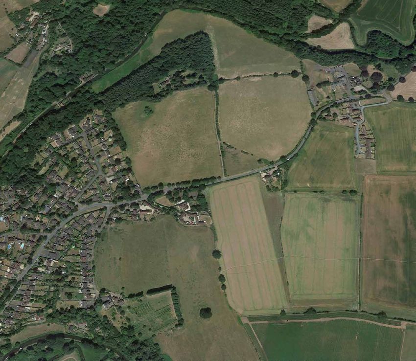
Contents

Introduction                          Heritage
Page 4                                Page 14
Site Context                          Green Belt Review
Page 5                                Page 15
The Vision                            Landscape
Page 6                                Page 18
Planning Policy Context               Transport
Page 8                                Page 20
SHELAA 2018                           Developing the Masterplan
Page 9                                Page 22
Site Specific Technical Assessments   Forecast Delivery
Page 10                               Page 23
Drainage                              Summary and Conclusions
Page 13                               Page 24

                                      Developing the West Midlands
                                      Socio-Economic Footprint in 2019
                                      Page 25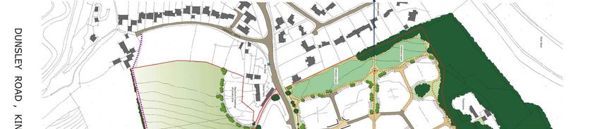
Introduction
               This vision document has been              This Vision Statement outlines the
               prepared by Savills on behalf of Barratt   development potential of Land at
               West Midlands in respect of their          Dunsley Road, Kinver. It explains
               land interests to the north and south      why the two sites are a suitable and
               of Dunsley Road, Kinver (hereafter         sustainable location for a residential led
               referred to as ‘Parcel A’ northen site     scheme for approximately 255 dwellings
               and ‘Parcel B’ southern site).             and should be a preferred location for
                                                          a residential allocation to help meet
               Barratt Developments PLC are the
                                                          the growth requirements of South
               nation’s largest housebuilder, having
                                                          Staffordshire District and the Greater

255
DUNSLEY ROAD
               built almost 500,000 dwellings in its
               60 year history. Barratt Developments
               PLC is proud of its industry-leading
                                                          Birmingham Housing Market Area
                                                          (‘GBHMA’) in the South Staffordshire
                                                          Local Plan Review.
PROPOSED
               reputation for quality, innovation and
               great customer service. Its commitment     The two sites are both adjacent to the
DWELLINGS      to the highest standards of design,
               construction and customer service has
                                                          existing settlement boundary of Kinver
                                                          and are currently within the Green Belt.
               enabled it to achieve HBF 5 star status
                                                          The two sites can deliver housing and
               for 10 consecutive years.
                                                          supporting infrastructure including
               This development would be a                significant amounts of open space and
               dual brand Barratt and David Wilson        a community facility in a sustainable
               Homes scheme, which will provide a         location with good access to a range
               varied housing product from starter to     of services and facilities offered within
               family homes.                              Kinver and Stourbridge. High
                                                          quality landscaping can be delivered as
               This document has been produced
                                                          part of the development to help blend
               to support the promotion of two
               separate sites for residential             the site into the surrounding area and
               development through the South              limit its impact on the landscape and
               Staffordshire Local Plan Review process.   adjacent heritage assets.

     4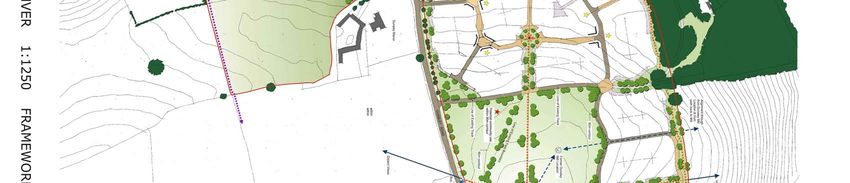
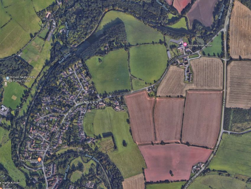
Site Context
    The sites comprise approximately           The village of Kinver provides a range
    17.8ha (41 acres) and are located in       of services and facilities required in
    the settlement of Kinver, an area to the   order to support significant residential
    east of the centre of Kinver. The sites    growth which includes a wide variety
    currently comprise agricultural fields.    of shops and services (at least 43
                                               non-convenience shops), two primary
    The sites are comprised of two parcels
                                               schools, a high school and sixth form,
    of land;
                                               a day nursery, two GP surgeries, 5
    Parcel A, of c.13ha, (32 acres) occupies   public houses, a library, a post office
    land north of Dunsley Road between         and various community centres.
    Grade II Listed Dunsley Hall to the
                                               A path running along the northern
    east, residential dwellings at Brindley
                                               boundary of Dunsley Road provides
    Brae to the west and the Staffordshire
                                               direct pedestrian access from the sites
    and Worcestershire Canal to the north.
                                               to Kinver village centre. Additionally,
    The net development area of Parcel
                                               there is a bus stop located 10m from
    A is considerered to be approximately
                                               the sites on Dunsley Road which
    7ha/17acres.
                                               serves a bus services that operates
    Parcel B, of c.3.5ha (9 acres), lies       between Kinver, Sourbridge (service
    to the south of Dunsley Road, south        228) and Kidderminster (service 580).
    of Dunsley Manor and Dunsley
    Manor Barns. Parcel B is bounded
    by agricultural fields to the south
    and east, and the Staffordshire and
    Worcestershire Canal, in part, to
    the west. The net developable area
    of Parcel B is considered to be
    approximately 0.4ha/0.9 acres

5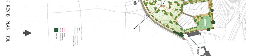
The Vision
The vision is to create an attractive,   The three key aspirations
welcoming, high quality housing          for the site are to:
development that will be a desirable
place to live that responds to
the site’s distinct qualities and
environmental setting.
                                                                     1) Create a sustainable development that
The proposed development, of land                                    benefits from the desirable and highly
located at Dunsley Road, Kinver                                      accessible location of the site, being in
will form a natural extension to the
                                                                     close proximity to shops, services and
settlement of Kinver.
                                                                     local facilities.
It will provide much needed market
and affordable housing
and new areas of public open                                         2) Develop a distinctive place, building
space in a highly sustainable                                        on positive elements of the existing
location. It will incorporate retained                               built environment, both existing and
and additional tree planting to                                      evolving in order to create a site specific
help blend the scheme into the                                       identity and character that is attractive
surrounding environment.                                             to new residents.

                                                                     3) Create a walkable neighbourhood,
                                                                     incorporating areas of new public
                                                                     open space and landscaping, helping
                                                                     to integrate and assimilate the
                                                                     development into the existing landscape.

               6
Parcel A
Dunsley A449
Dunsley Road
Parcel B
KinverPlanning Policy Context
Adopted Development Plan A consultation on the Strategic Local Plan Review Timescale
Spatial Strategy & Infrastructure
South Staffordshire Council’s adopted Delivery Consultation is being The April 2019 Local Development
Development Plan comprises the Scheme for South Staffordshire sets
undertaken between 21st October –
Core Strategy (adopted 2012) and the out the following timetable:
16th December 2019.
Site Allocations Document (adopted
September 2018). The consultation document sets out 7
The sites are located within the Green Spatial Housing Strategies (A-G) and • Strategic Spatial Strategy &
Belt (Policy GB1) and is immediately it states that the Council’s preferred Infrastructure Delivery Consultation
adjacent to the development strategy is ‘Option G - Infrastructure- – 21st October – 16th December 2019
boundary of Kinver. Parcel A is led development with a garden village
located to the south of the ‘Canal area of search beyond the plan
period’. This option will direct 60% of • Preferred Spatial Strategy and Sites
Conservation Area’ (Policy E3) and Document – Spring 2020.
Parcel B is located to the east of it. growth to Tier 1 – 4 settlements and
In the adopted Core Strategy and 40% of growth to urban extensions.
Site Allocations Document, Kinver is Although there are no figures
• Publication Document
identified as a ‘Main Service Village’ provided in the document stating the
- Winter 2020/21
which are the main focus for housing amount of growth that will be directed
growth and service provision. to each settlement, from the Option
G key diagram, approximately 1/8 of
Local Plan Review the growth proposed in Kinver will be
• Submission of Local Plan
– Autumn 2021.
The Council is currently reviewing met by additional housing than those
their Development Plan and is already identified in the adopted Site
undertaking a Local Plan Review Allocations Document.
• Local Plan Examination
which will include additional housing – Winter 2021/2022
allocations to meet the District and
Housing Market Area’s needs up to
2037. The two sites were submitted
• Adoption of Local Plan
to the Council for consideration for
– Summer 2022
residential development during the
Issues and Options consultation in
November 2018.
8SHELAA 2018
DUNSLEY ROAD NORTH
The latest Strategic Housing Parcel B - Land south of Dunsley
and Economic Land Availability Road (Site 550)
Assessment (SHELAA) was updated
Parcel B is assessed using a site
249
in October 2018. In the 2018 SHELAA,
area of 8.67Ha which is greater than
both Parcels A and B have been
the circa 0.94Ha and 6 dwellings
assessed are located within
which is now being proposed. The
17.12Ha
‘Locality 5’. It should be noted the
SHELAA assessed the site’s capacity
SHELAA assessment is based on a
for 166 dwellings and concludes
larger site area for both parcels which
that the site is ‘not suitable - the
has now been reduced.
14.5
site is disassociated from any village
Parcel A - Land north of Dunsley development boundary’. The site
Road (Site 549) assessment for Parcel B states that
PER HECTARES ‘The site is not directly adjacent to
Parcel A described in the SHELAA as
the development boundary of Kinver,
having a gross area of 19.45Ha with
and can only access the village via a
DUNSLEY ROAD SOUTH a capacity of 373 dwellings using
narrow lane and a road with no formal
6
SHELAA assumptions. With regards
footway (Dunsley Road). Site modelled
to deliverability, the site is assessed
at 32 dwellings per hectare.’.
as being ‘potentially suitable but
subject to policy constraints – Green It is considered that the site is not
Belt’. The site assessment for disassociated from the settlement
Parcel A reads: ‘Site is directly as it is immediately adjacent to
adjacent to the Kinver development existing properties on Dunsley Road.
0.94Ha
boundary and borders a Canal It is acknowledged that a limited
Conservation Area to the north. number of dwellings can be served
Village edge site modelled at 32 off the existing access. Therefore
dwellings per hectare’. the proposed housing yield has been
6.38 PER
HECTARES
The only major constraint identified
for this site is the Green Belt. The
Green Belt is currently under review
amended as part of the Submission.
The revised site area and proposed
yield is considered to be more
suitable for the site. Therefore, the
and consider that Parcel A is a
site is a suitable option for release
suitable location for release from
from the Green Belt and allocation for
9 the Green Belt and allocation for
residential development.
residential development.Site Specific Technical Assessments
Preliminary Ecological Assessment
An Ecological Assessment of the two sites was undertaken to identify potential ecology
constraints to development and to inform recommendations to the masterplan design.
Protected Sites Protected Habitats
There is a single European designated Parcel A supports the following habitats:
site within 10km of the sites (Fens Pool
Special Area of Conservation (SAC)) • Buildings;
and a single nationally designated • Boundary fences;
site within 2km of the sites (Kinver
Edge Site of Special Scientific Interest • Hedgerows;
(SSSI)). It is considered unlikely
• Species-poor semi-improved
that development of the two sites
grassland;
for housing would affect the Fens
Pool SAC or the Kinver Edge SSSI. • Scattered broadleaved trees;
Increased visitor pressure on the SSSI
will be assessed and mitigated against • Standing water.
at planning application stage. Parcel B supports scattered broad
There are also five Sites of Biological leared trees along the boundary and
Interest (SBIs) within 1km of the two species-poor semi-improved grassland
sites (Staffordshire and Worcestershire Habitats directly adjacent to the
Canal, Hyde Lock, The Hyde, south sites include:
west of The Hyde and Potters Cross).
• Arable fields;
It is envisaged that the potentially
adverse impacts could be mitigated by • Plantation woodland.
providing suitable recreational open
It is proposed that the boundary trees
space and creation/enhancement of
and hedgerows across the sites are
multi-functional green infrastructure
retained, where possible, within the
within the Site.
green infrastructure enhancements
10 proposed as part of the comprehensive
development proposals.Preliminary Ecological Assessment
Protected Species Recommendations
Although no protected species surveys It is considered that through
have been undertaken, the Preliminary appropriate and sensitive
Appraisal identified that there is masterplanning that the development
potential for the presence of several could be designed to be in conformity
protected and priority species within with local and national planning policy
the sites and their vicinity including: and legislation afforded to wildlife.
The following main principles have
• Great Crested Newts; been adopted:
• Badgers; • Focused built development in the
areas of lowest ecological importance
• Bats; (grassland fields);
• Breading Birds; • Retain the existing hedgerows and
scattered trees, as far as is practical,
• Doormouse;
within multifunctional
• Hedgehogs; green infrastructure;
• Invertebrates. • Creation of new areas of native
species-rich grassland, hedgerows,
waterbodies, and scrub, which would
benefit local biodiversity by providing
nesting, foraging, and shelter for a
range of species and species groups
including birds, mammals, and
invertebrates; and
• In the future, a management
strategy could be developed for public
access to and maintenance
of the green infrastructure, to
provide interpretation and education
materials for new residents to
promote ownership and encourage the
conservation and protection of
11 these features.Preliminary Arboricultural Assessment
A high level arboricultural appraisal The following recommendations
has been undertaken on the sites to were made by the Tree Consultant
provide a preliminary review of the and have been incorporated into the
current context and condition of trees illustrative masterplan for the site
on and within influence of the sites. where possible:
The majority of the trees on the • Individual mature trees are areas
sites are in a typical condition for of tree belt and woodland which
its context, age and species and should be retained and protected
are largely influenced by farming from development activities where
practices and adjoining highway. practicable.
Some of the internal hedgerows,
• There should be an allowance for
suffer from poor management
development offsets from retained
and have notable gaps in places.
trees to accommodate the Root
Individual mature trees are notable
Protection Areas and canopy
features of the site of moderate to
shading.
high value and quality. The Parcel A
boundary trees adjacent to Dunsley • Boundary tree and hedgerow
Road form a cohesive tree belt, enhancement adjacent to Dunsley
providing a degree of visual screening Road should be sought to maintain
into Parcel A from Dunsley Road. a visual screen and noise barrier
The majority of trees adjacent to into Parcel A.
the proposed access route to the
land south of Dunsley Road are of • Explore options for strengthening
low arboricultural value. However, a tree and hedgerow cover
moderate value group of ash trees along existing roadsides and
and a mature lime tree of high field boundaries to enhance
arboricultural value were identified. the containment and habitat
connectivity across the periphery
of the sites.
12Drainage
A desktop study into the possible Where standard density residential
sources of flood risk and a preliminary development is proposed, a 60%
surface water drainage assessment impermeability has been assumed.
was undertaken for the site. Where higher density residential
development is proposed, a 65%
The sites are in Flood Zone 1 and are
impermeability has been assumed.
at low risk of flooding from all flood
To provide a conservative approach,
risk sources.
a 10% allowance for urban creep has
The existing sites are wholly greenfield been made for the entire development
in nature, with no formal drainage as the specific density is unknown. As
infrastructure evident. Given the the development proposals progress,
geology of the sites it is expected that the urban creep allowance may be
surface water runoff largely infiltrates able to be reduced in line with the
into the ground. When the infiltration above table.
▶
potential of the ground is exceeded,
A conceptual drainage strategy
runoff would flow overland towards the
has been prepared which
low points of the site.
demonstrates that a suitable solution
Given the current drainage regime can potentially be achieved for
and the geological characteristics, surface water drainage at the sites.
it is likely that the sites will prove The primary option, in line with the
conducive for the use of soakaways. drainage hierarchy, is infiltration.
13Heritage
A Heritage Appraisal was undertaken The Staffordshire Historic Environment
to outline the significance of the Record (HER) details several features
designated and non-designated and structures which may be
heritage assets and their settings considered non-designated heritage
within the sites and in the vicinity of assets or of note within the historic
the sites which may be sensitive to the environment at Kinver and Dunsley.
proposals, and consider the potential The HER identifies the site of a
impacts of the proposed development windmill (also known as Dunsley Mill)
of the sites on the heritage assets within Parcel A.
therein and in the vicinity of the Site.
In order to limit the impact of the
The sites does not contain any proposed development on the adjacent
designated heritage assets. The heritage assets, Dunsley Hall and
Staffordshire and Worcestershire the Staffordshire and Worcestershire
Canal Conservation Area runs to the Canal Conservation Area, and their
North of Parcel A and West of Parcel settings buffer zones are proposed
B. Parcel B is also adjacent to the in order to restrict built development
Kinver Conservation Area. The Grade adjacent to these assets. Additionally
II Listed Dunsley Hall is located to the the design of the development will
east of the Parcel A. Further Listed incorporate an appropriate scale,
Buildings are located to the north and density and use of materials to further
south of Parcel A and North and West limit the developments impact on
of Parcel B, including the Grade II* adjacent heritage assets and no built
Whittington Inn and Grade II Listed development is proposed on the site of
Dovecote at Hyde Farm. However, the former Dunsley Mill in Parcel A.
these are not considered sensitive to
the proposed residential development
at the sites due to the intervening
distance, topography and landscape.
14Green Belt Review
South Staffordshire has published a Green Belt Study (2019) with the Local Plan
Review consultation. Parcels A and B are located within Parcel S81A. Part of Parcel
A is identified as forming part of parcel S81As1 which has a ‘High’ Green Belt rating.
However the western part of Parcel A and the whole of Parcel B is located within
parcel S81As3 which has a ‘Moderate’ rating. We have assessed the sites’ against the
five purposes of the Green Belt and set out responses on each of the purposed below:
Checking Unrestricted Sprawl enclosure to development that
restricts any physical or perceived
• There is the potential for
merging of Kinver with the
development to contribute towards
settlement of Stourton.
sprawl if ribbon development
extends along Dunsley Road Safeguarding the Countryside
adjacent to Parcel A. It is proposed from Encroachment
that development should be set back
• The Council’s evidence identifies
from the road and soft landscaping
a ‘Strong’ contribution to this
should be utilised to provide a robust purpose with little explanation. The
and permanent offset. Development Green Belt Study states, ‘…Land
of Parcel B will sit adjacent to contains the characteristics of open
existing properties off Dunsley Road countryside and does not have a
so it is not considered to make a stronger relationship with the urban
contribution to this purpose. area than with the countryside’.
However, as previously described,
Preventing Neighbouring Parcels A and B are located adjacent
Towns Merging to the existing settlement of Kinver,
• Parcels A and B are not considered and whilst development of both
to play a major role in maintaining parcels would constitute a loss of
grassland fields, avoiding sensitive
separation between settlements and
areas could allow for a suitable
therefore do not contribute towards
improved development edge without
this purpose. The incorporation impacting on the wider landscape.
of development offsets from the Avoiding development on the high
eastern boundary of Parcel A can ground of Parcel A will limit visual
15 ensure a robust and permanent impact from distant views.Green Belt Review Continued
Preserve the Setting and Special Opportunities for the Release of
Character of Historic Towns Green Belt
• The sites do not form part of the In summary, both Parcels A and
setting of a historic town and B make a limited contribution to
therefore they do not contribute the wider landscape when careful
towards this purpose. mitigation is incorporated. Whilst
the development of Parcel A and B
To assist in Urban Regeneration by
would lead to a loss of grassland
Encouraging the Recycling of Urban/
fields, the function of the wider Green
Derelict Land
Belt in checking unrestricted sprawl,
• All parcels in the District are preventing coalescence of settlements
considered to make an equal would be retained. Any loss of land
contribution to this purpose. to development would be limited
and localised.
The release of both sites for
development also offers opportunities
for enhancements through the
provision of accessible open space.
Both Parcels A and B contain physical
boundaries which are recognisable
and defensible in the form of
hedgerows and hedgerow trees.
16Green Belt Review Continued
Opportunities for Release of Green In addition to requiring the release
Belt Land of Green Belt land to be clearly
As considered above, the sites make defined by robust new Green Belt
a limited contribution within the boundaries, the NPPF also considers
wider Green Belt and landscape when at paragraph 138 that plans should,
careful mitigation is incorporated. ‘…set out ways in which the impact
The northern sites are contained by of removing land from the Green Belt
existing recognisable and permanent can be offset through compensatory
boundaries formed by Dunsley Road improvements to the environmental
to the south, existing development quality and accessibility of remaining
to the east (Dunsley Hall and farm), Green Belt land.’
woodland and a residential dwelling Although the sites do not offer the
to the north. Whilst development of the opportunity for enhancement of land
site would lead to a loss of 4 grassland retained in the Green Belt (in line
fields, the function of the wider Green with the 2019 NPPF), They do offer
Belt in checking unrestricted sprawl, the opportunities for enhancements
preventing coalescence of settlements through the provision of accessible
would be retained. Any loss of land to open space especially within the
development would be limited northern parcel on the higher land
and localised. absent of development. As illustrated
As set out at paragraph 139 of the on the Opportunities and Constrains
2019 NPPF, when defining Green Belt Plan, there are further opportunities
boundaries, plans should, ‘define for this space to be enhanced with
boundaries clearly using physical characteristic new structural planting
features that are readily recognisable to assist with filtering views of the
and likely to be permanent.’ As stated proposed development, as well
above, the sites contain physical as being managed for wildlife and
boundaries which are recognisable biodiversity benefits. Currently, review
and defensible in the form of of the sites are publically accessible
woodland, Dunsley Road, Dunsley but if developed, public open space
Hall and a sloping topography to the will be provided as part of the
east. This provides the opportunity to development proposals which will
reinforce and enhance these hedgerow benefit the local community.
17 boundaries with additional planting to
further filter views.Landscape
South Staffordshire’s Landscape contained both physically and visually,
Assessment 2019 has been reviewed in with existing properties to the south of
regards to the Parcels A and B. Dunsley Road screening views from the
north, existing properties off Dunsley
Landscape Sensitivity Drive to the west and mature tree belt to
Both Parcels A and B are located within the south.
parcel ‘SL2’ within the Landscape Landscape Recommendations
Assessment 2019 which scored a
‘moderate-high’ sensitivity rating. This A series of recommendations were made
rating is in relation to a considerably by Barratt West Midlands’ landscape
larger area than the sites. The consultant which have been incorporated
assessment commentary for this option into the Concept Masterplan. The
states that ‘gently undulating areas recommendations for Parcel A include;
with a good level of containment (due the retention of the existing mature
to topography or vegetation) and that trees along Dunsley Road, restricting
relate well to the existing settlement development on the higher ground in
edge of Dunsley north and south of the south eastern part of the site and a
Dunsley Road, have moderate sensitivity landscape buffer towards the northern
to development’. This directly relates to part of the site. Recommendations for
both Parcels A and B, where the reduced Parcel B include; retaining existing
judgement of ‘Moderate’ sensitivity is vegetation where possible between the
appropriate; both sites relate well to the site and existing dwellings and providing
existing residential edge of Kinver and a robust landscape buffer at the eastern
development considerations avoiding the edge of the site to provide a new
upper contours will reduce the overall defensible and permanent edge to the
impact on the local landscape. proposed built development.
Visual Context It is considered that the actual
area of land being promoted for
Visually, Parcel A is well enclosed to the built development within both sites
north by existing boundary vegetation along with the significant green
with the area of land and woodland infrastructure proposed will result in
corridor adjacent to the River Stour and less impact on the wider landscape
Staffordshire and Worcestershire Canal,
18 in addition to the existing residential
than has been assessed as part of the
wider parcel SL2.
edge to the west. Parcel B is well-N
A
60m
A
C
IR E
65m
H IR
A development offset is recommended from the eastern part
E
Site Boundary
S H
Filter Distant Views of the northernsite to address the more rural character in
70m
R S
this area as well as the open nature of the higher ground. The
E D
Development Frontage Considerations Potential Site Access
75m approach to the village of Kinver from the east can be respected
S OR
Potential Development Parcels and enhanced by retaining this development offset so that the
Former Dunsley Mill
C FF
80m
T
character of the street-scene on the approach is retained.
Potential Development Parcels with a higher
R A
Opportunity to Reinstate Historic Field
E
density consideration
T
Boundaries
S
Potential Public Open Space and Development
PotentialA rea for SuDS / Landscaping
DUNSLEY
O
Planting
W
85m HALL
19
Existing Public Rights of Way
U R
R
T VE
I
O
R
DUNSLEY
S
H A L L FA R M
90m
94m Development should be restricted
Sort out layout on the higher ground in this location
to avoid new built form being overly
prominent in the surrounding
Development of the sites will represent an extension of the landscape and when the settlement
settlement eastwards and the creation of a new settlement edge is viewed from the public
approach. In order to ensure the existing character of the village footpaths to the south.
AD
approach is retained and where possible, enhanced, it will be
Y RO
important to consider the incorporation of a landscape buffer/
N SLE
development offset, and the appearance of the new dwellings on DU
the eastern and southern edges of the development. Outwards The existing mature trees along the
facing properties, with scattered tree planting and an area of roadside should be retained and
open space at the outer edge of the development would be protected, with development set-
consistent with the existing edge of the village and characteristic MANOR
DUNSLEY back from the road to ensure their
features can be incorporated. The gentle rise in ground levels in1 FA R M MANOR protection, as well as to provide a
this location can be utilised to define the development edge and visually filtered view of new built form
landscape buffer width. and the new settlement edge.
A robust landscape buffer should be provided at the eastern edge
of the southern site to provide a new defensible and permanent
edge to the proposed 6 dwellings to secure the remaining green
belt land beyond, as well as to ensure the open aspect of this part
of the site is respected.Transport
Existing Highways Network Proposed Development Impact on
Highways
The site are situated on land adjacent
to the north and south of Dunsley Road, For the purposes of calculating the
approximately 950m northeast of Kinver traffic generation for these assessments
Village centre. To the east Dunsley Road it has been assumed that maximum
connects to the A449 which provides total of 450 dwellings could be provided.
links to Stourbridge and Kidderminster. The potential impact of the vehicle trip
Dunsley Road ranges in width between generation on the local highway network
5.3m at its narrowest to 6.75m. Along the would be minimal with a 10% impact
site frontage Dunsley Road is subject to daily predicted on the A449 to the east of
a 60mph speed limit. The limit reduces the sites.
to 30mph at the junction with Hampton
Grove to the west of the site. The existing footway on Dunsley Road
will be required to be improved to provide
Automatic Traffic Count (ATC) surveys pedestrian facilities between the site
were undertaken to record traffic volume and the village to the west. Appropriate
and speeds on Dunsley Road. The result footways and crossing facilities will also
of the ATCs show that the average daily be required to ensure that the southern
traffic flow was recorded as 4,708 two- site is accessible for pedestrians.
way vehicles with an 85th percentile
speed of circa 38mph in both directions. The results of the ATC speed surveys
Peak hour movements were recorded as indicated that the 85th percentile speeds
240 two-way vehicles in the morning peak of vehicles using Dunsley Road is 38mph
hour and 368 in the evening peak hour. compared to the posted 60mph speed
limit. The access junctions have therefore
The nearest public transport been designed with 120m visibility splays.
infrastructure to the sites are bus stops
located on Dunsley Road on both sides of To enhance the future more residential
the carriageway these stops are served nature of Dunsley Road, a case could be
by bus routes 227 and 228 operated made to reduce the road speed to 40mph
by Diamond Buses which provide in line with the recorded speeds.
connections to Stourbridge centre, with a
bus serving the road every 60 minutes in
20 both directions on weekdays.Transport Continued
Access The ATC survey identified that the
background traffic flows on Dunsley
The northern site is currently accessed
Road are relatively low. Hence, the
via a track that serves an existing
capacity of the site access junctions
building and varies from 2.31m to
would not be a constraint to the
2.58m in width, the southern site is
number of dwellings on the site.
currently accessed via a track that
Instead the number of accesses
ranges from 2m to 2.4m. in width.
will be a determining factor. Therefore,
It is recommended that two it is anticipated that the sites could be
access points are provided into the accessed via simple priority-controlled
northern plot, as either two formal T-junctions.
access points or one access and an
The illustrative masterplan set out in
emergency access. A single access
this document demonstrates suitable
point would be sufficient for the
potential access point locations.
southern site which could serve
6 properties.
21Developing the
Masterplan
Both sites are capable of delivering
a high quality, residential-led
environment with associated open
space and potential community
use which will blend in with the
existing settlement.
An indicative masterplan has been
prepared by Barratt to illustrate
how a scheme here could be
developed. Through its development,
the constraints and opportunities
identified, both on and off site,
have been considered, which will
incorporate landscape and historical
influences.
It is anticipated further engagement
with the Local Authority will be
undertaken through the Local Plan
and ultimately the pre-application
process, along with a public
consultation, to ensure views are
taken into account to prepare the
final masterplan for the sites.
22Forecast Delivery
As a national housebuilder, Barratt have the ability to deliver housing on the site swiftly
and to assist in meeting the Housing Requirements of the District in the short term.
In this instance, this will be a joint development between Barratt and David Wilson
Homes. As such there will be two outlets which would deliver circa 70 dwellings
per annum.
2022/2023 2023/2024 2024/2025 2025/2026
Private Units 27 42 42 42
Completed
Affordable Units 18 28 28 28
Completed
Total 45 70 70 70
*The above figures are based upon Barratt’s financial years which end on the 30th June.
23Summary and Conclusions
The Vision Statement demonstrates how Barratt Homes can create a high quality
residential development to include a community use and public open space on
land off Dunsley Road, Kinver making a valuable contribution to the District and
GBHMA’s housing requirement as well as providing public benefits.
South Staffordshire Council is part of the Local Plan Review.
currently reviewing their Local Plan. It is not considered that the site
It is considered that Parcels A and performs well against the purposes of
B are suitable and sustainable sites the Green Belt and should therefore
for residential development which be considered for release.
should be considered for allocation in
The Masterplan for the sites has
the Local Plan Review document. The
been landscape and heritage led and
Sites are immediately adjacent to the
it is therefore considered that the
settlement of Kinver and are within
development proposals will have a
walking distance of the village centre
limited impact on adjacent landscape
which offers a range of services and
and heritage assets. The development
facilities. The Sites are also within
will provide significant areas of open
10m of a bus stop on Dunsley Road
space and potential community uses
which provides frequent services
to the benefit of both existing and
between Kinver and Stourbridge.
future residents. Barratt are keen
No significant environmental or to engage with both the Council and
heritage constraints have been local residents and will undertake
identified through the technical work public consultation with regard to
that has been undertaken by various matters such as the design of the
consultants. The only constraint development, public open space
identified is a policy constraint as the and the type and scale of potential
site is located within the Green Belt community uses that the community
which is currently under review as may require.
24INVESTING IN NEW HOMES EMPLOYMENT AND
SKILLS DEVELOPMENT
Developing the
West Midlands 592 44% 1,261 jobs £80m 27
new homes (including of homes built on
Socio-Economic
Direct, indirect and of Gross Value graduates, apprentices
joint ventures) of which previously developed land induced employment
127 are affordable Added (GVA), and trainees on
through direct employees, contribution to UK programme
Footprint in 2019
sub-contractors and economic output
suppliers equivalent to
2 jobs per dwelling
SUPPLY CHAIN NETWORKS SUPPORTING PUBLIC SERVICES
The infographic provides an
illustration of our socio-economic
footprint for the financial year 2019.
The assessment was carried out by 90% 380 460 £3.7m £23m
independent consultants Lichfields, of components sub-contractor companies supplier companies New Homes Bonus tax generated
manufactured supported (including supported (including payments by Government Corporation Tax, NI, PAYE, SDLT and
who analysed socio-economic in the UK through joint ventures) through joint ventures) over 4 y of components local Council Tax generated (p.a.)
impacts through the delivery manufactured in the UK by our activities
chain for new housing based upon
Barratt Developments PLC datasets, BUILDING STRONGER COMMUNITIES
published research and national
statistics. All figures are based
on the financial year ending
30th June 2019. £1.6m £17m 57 £9.9m
local contributions expenditure on physical works benefiting school places provided spending in shops and services by
including s106 and local communities (including highway residents of new homes (p.a.) supporting
equivalent contributions and environmental improvements and 100 retail and service-related jobs (p.a.)
community facilities)
SAFEGUARDING THE ENVIRONMENT
2,882 26.2ha 82% 2.57 7.88 97%
trees or shrubs of green space of developments tonnes of CO2e tonnes of waste of construction waste
planted or created through using above ground emissions per 100m.sq. diverted from
25 retained on
developments
public open space
and private gardens
landscape-led
Sustainable Urban
per 100m.sq.
completed build
completed build area landfill
Drainage Systems area (scope 1, 2 and
limited scope 3)You can also read