SCENARIOS AND STRATEGY FOR DRAMA - EUKI
←
→
Page content transcription
If your browser does not render page correctly, please read the page content below
CYCLURBAN
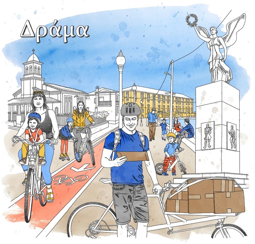
SCENARIOS AND STRATEGY FOR
DRAMA
National Technical University of Athens & Municipality of Drama, 2020
The project ((Nr. 17.9045.0-002.17/81218709) is part-financed by the
European Climate Initiative. This initiative is a funding programme of the
German Federal Ministry for the Environment, Nature Conservation and
Nuclear Safety (BMUB), administered by the GIZ. The overarching goal of the
European Climate Initiative is to foster climate cooperation within the
European Union to mitigate greenhouse gas emissions.
Page 1 of 67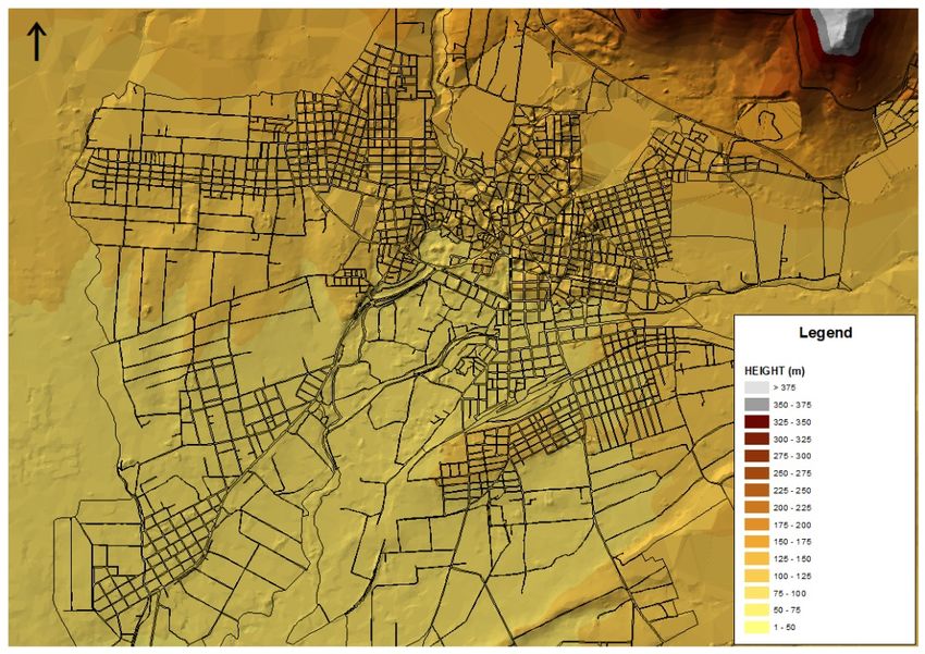
Contents
1     Presentation of the Municipality of Drama....................................................................... 3
2     Presentation of the city of Drama ...................................................................................... 5
    2.1       Road network .......................................................................................................................... 6
    2.2       Walkability-Bikability ............................................................................................................. 9
    2.3      Population density and land uses........................................................................................... 10
    2.4      Public transport and cycling network .................................................................................... 12
    2.5      Environment .......................................................................................................................... 13
3     Presentation of SUMP (NTUA’s research project) ........................................................ 15
    3.1      New hierarchy ....................................................................................................................... 15
    3.2      Green Routes ......................................................................................................................... 18
      3.2.1          Main Attributes.............................................................................................................. 18
      3.2.2          Description .................................................................................................................... 19
4     Cyclurban strategy ............................................................................................................ 25
    4.1       Short Term Scenario.............................................................................................................. 25
    4.2       Mid-term Scenario................................................................................................................. 28
    4.3       Long Term Scenario .............................................................................................................. 31
    4.4       Categorization of the measures ............................................................................................. 32
    4.5       Cost........................................................................................................................................ 32
5     Conclusions ........................................................................................................................ 36
Appendix A: Short – term selected routes .............................................................................. 37
Appendix B: Mid – term selected routes ................................................................................. 52
Appendix C: Long – term selected routes ............................................................................... 60

                                                                    Page 2 of 67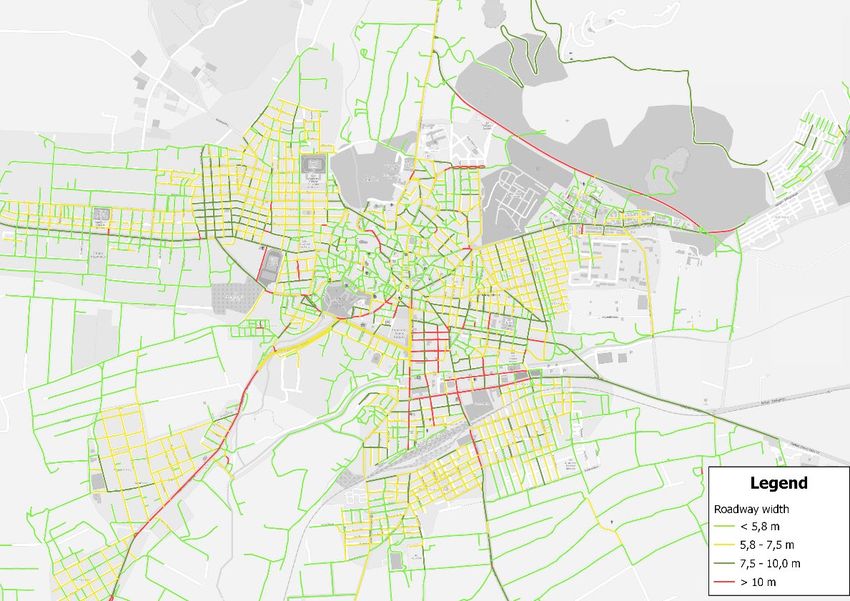
1    Presentation of the Municipality of Drama
The Municipality of Drama is located in the Region of East Macedonia and Thrace in northern Greece.
The north border of the municipality is the border of Greece with Bulgaria, also member of EU. The
size of the municipality area is 833.01 km² and its population is 58,944 residents, as it is recorded in the
last census in 2011. The municipality is mainly divided into two administrative sectors i.e. the municipal
sectors of Drama and Sidironero.
The terrain of the Municipality of Drama is mountainous in the north and lowland in the south, as it is
shown in the Map 1a. The mountain range of Rodopi, located in the north part of the municipality is one
of the highest and most important in Greece. Settlements like Livadero and Taxiarchies and the entire
municipal sector of Sidironero are located in the mountainous section, while the city of Drama and its
surrounding settlements are located in the valley between the mountains of Pagaio and Falakron. The
River of Nestos crosses (i.e. from the east to west) the municipality area in the north part, between the
massifs of Rodopi.

                                        Map 1a: Municipality of Drama

The city of Drama is very significant for the Region of East Macedonia and Thrace. Other significant
urban centers in this region are: Kavala, Xanthi, Komotini and Alexandroupoli. Drama as a municipality
has strong relations with the Municipalities of Kavala and Xanthi. From Drama to Kavala and Xanthi,
the shortest road distances via motorways are 37.4 and 89.4 km respectively. The first city has some
transport facilities, such as airport (not international) and sea port, that are significant for the economic
activities of the Region, Xanthi is the second most populated city of Thrace with a population of 56,122
residents. Furthermore, the city of Komotini is the capital of the East Macedonia and Thrace Region;
therefore, many administration services are located there. Relations also exist with municipalities within
the neighboring regions, such as the Municipalities of Serres and Thessaloniki. The road distance

                                               Page 3 of 67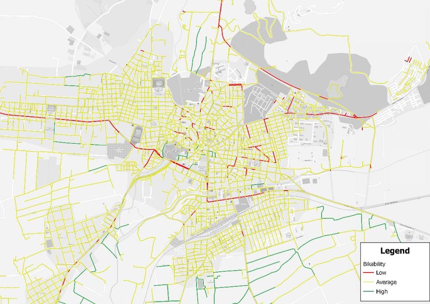
between Drama and Serres is 70 km. Thessaloniki is the most populated metropolitan area in Macedonia.
The nearest from Drama international airport is located in the previously mentioned city; the road
distance is 164 km. The metropolitan area of Thessaloniki is important for the entire northern Greece,
because it concentrates a plethora of economic activities, like commerce, businesses, education-research
centers, public and private services etc.

                           Map 1b: Dependencies of Drama with region municipalities

                                               Page 4 of 67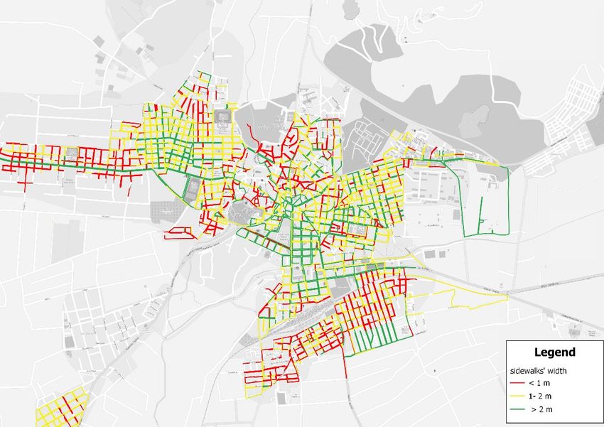
2    Presentation of the city of Drama
Drama is a small city located in northern Greece with a population of 45,000 residents. Built since the
ancient classical era and further expanded during the Ottoman Empire, has a complex urban form with
unregulated spaces and poor street geometry. The city's surface is divided into three sections with
different forms and attributes; a) the historic center with narrow streets, small houses and arbitrary built
structures; b) several areas located in the outskirts of the city center, which have been recently
reconstructed; and c) lastly the southeast suburbs which were developed following the grid plan system
with low density housing. Within the outline of the city plan (incl. the aforementioned areas) there are
large green spaces, some of them located in the historic center (St. Barbara's Park and the Municipal
Garden). As in most Greek cities, Drama is a car-oriented city. The use of the private car is particularly
high reaching 88% of the total trips, while 6% of them is made by motorcycle. Few streets have been
pedestrianized in the city center, while recent policies in the area include traffic restrictions for access
regulation and some bicycle tracks.
The city of Drama occupies an area of 498.8 ha and is located in the southern part of Drama
Municipality, in the valley between Pagaio and Falakro Oros. It neighbors with settlements such as
Arkadikos, Nea Pamisos, Choristi, Ksiropotamos, Monastiraki, Kallifitos and Nea Sevasteia. The
population of the other settlements is significantly low, compared with Drama. Hence, the city is
definitely the major center in the area.
The location of Drama is crucial for the whole municipality. The city has a great level of
interdependencies with the neighboring settlements, undoubtedly constituting the basic center in the
area. All of the surrounding settlements have been developed in accordance with Drama.
Correspondingly, these settlements have been affected by urban sprawl, therefore a considerable number
of commuters live in Drama and work at the settlements or reversely. In general, the southern part of
the municipality composes a significant network of settlements.
The first human presence in the wider area of Drama is dated from the Middle Neolithic period. Since
then continuous human presence exists in the area. During the Ottoman Empire rule the population of
the city increased dramatically, therefore the city exceeds the limits of the Byzantine walls. After the
integration of the city in the Greek territory, the city experienced several changes. The main factor that
affected the form and the structure of the city was the great number of immigrants that moved to Drama,
seeking for a better future. As a result, new areas were built in the surroundings of the traditional urban
area. The morphology of these new areas is completely different from the existing one, as it is
characterized by rectilinear streets and rectangular blocks. On the other hand, the reconstruction plan of
the old city mostly maintains the existing street structure of the traditional core. However, some
interventions such as roadway widening or opening of new roads were implemented mainly in the
Muslim part of the city. In the beginning of 1930’s, the study of the new plan of the city was approved.
Nevertheless, this plan could not contribute to the development of the city, but instead it led to serious
shortcomings, which still exist nowadays. Fortunately, the incomplete implementation of the plan
resulted in the preservation of a plethora of important buildings inside the city. Some of these buildings
are the church of Agia Sofia, several tobacco warehouses, Kursunlu Mosque, Byzantine Walls,
complexes of Neoclassical Buildings, etc.

                                               Page 5 of 67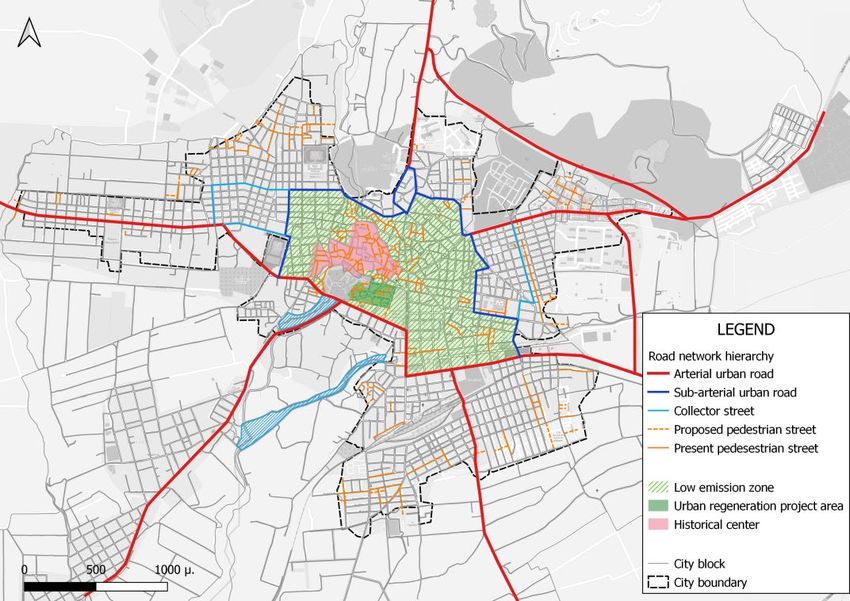
Map 2: Division of city of Drama in three sections

                                            Map 3: Terrain of the city

Regarding the relief/terrain of the area, it should be noted that the bigger part of Drama is lowland with
no intense slopes (50% of the road network has a slope of less than or equal to 2%). Focusing on its
historical and commercial center, conditions slightly change, as slopes exceed 5%. Furthermore, a hilly
area is located in the northern part of the city, where slopes are significantly higher and approximately
reaching 10%.

2.1   Road network
The main road network of the urban area is classified into 3 main categories, which are: primary,
secondary and collector roads (see Map 4a). Concerning the city center, it should be mentioned that
intense traffic is mainly observed in the areas around the central squares and streets, due to the intensive
commercial activity that takes place. Regarding the historic center, the creation of walking streets,
contributed to the improvement of the road environment considerably and reinforced the attractiveness

                                                 Page 6 of 67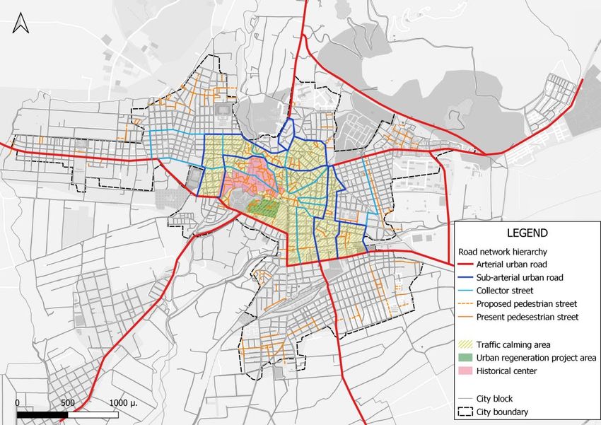
of the city. The rest of the roads are mainly narrow and they do not serve significant numbers of traffic
flows, as they lead to residential areas. The only collector street inside the historic center, is Agias
Varvaras street that connects the southern part of the center with the new center of Drama (public
services and administration uses), but the traffic flow passing through this segment is not significant.

                                Map 4a: Hierarchy of road network and land uses

Concerning the existing roadways width, it should be noted that 41% of road network length is not
suitable for accommodating two-way traffic. As for the current sidewalk width, it has to be mentioned
that the majority of sidewalks is characterized by medium or high values of width. The only exception
is the historical center, where the narrow form of streets did not allow the construction of acceptable
sidewalks, therefore the observed width values are significantly lower. Furthermore, the width of
approximately 50% of the sidewalks do not meet the appropriate requirements (at least 2.1 m overall
width including 1.5 m of a walking free corridor). In the majority of the road network segments,
sidewalks with width between 1.5 to 3m have been recorded. However, in the outskirts of the city the
absence of sidewalks is frequent. The road and sidewalk widths are presented in Maps 5a and 5b,
respectively.
The city of Drama has no parking issues in general. As it can be seen in Map 5c, the only area that faces
some worth mentioned parking challenges is the central core of the city, where due to the high density
of activities, the demand for parking is definitely greater. These disturbing conditions are exacerbated
by the residents of neighboring settlements that reach the city with their private vehicle and they seek to
park directly in the central area. Regarding the other residential areas, it should be noted that parking
intensity is significantly low.

                                                Page 7 of 67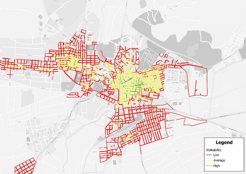
Map 5a: Roadway width

Map 5b: Width of the sidewalks

       Page 8 of 67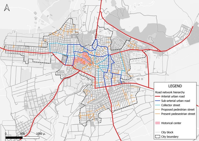
Map 5c: Parking intensity

2.2   Walkability-Bikability
Walkability or walking accessibility constitutes one important indicator depicting the existing condition
regarding mobility in urban areas. In the case of Drama, walkability index presents values from 0 to 15
and road are divided into 3 categories. This index takes into consideration factors such as sidewalk
width, population density, land uses proximity and connectivity. Other factors that could be used in the
future would be land use mix level, sidewalk condition as well as obstacles existence.

                                            Map 6: Walkability

                                              Page 9 of 67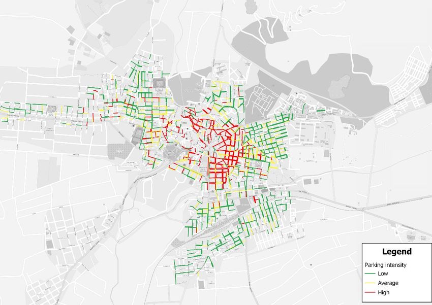
Map 7: Bikability

Regarding the geographical dimension of walkability index, it should be noted that in the western and
northern part of the city (residential area), walkability values are significantly low at the vast majority
of streets. This fact means that safe and comfortable walking is definitely neglected. Focusing on the
city center, where the social and commercial vibrancy is high, the conditions concerning walking are
significantly better as the majority of street segments were graded with medium and high walkability
values. As for the area south of the city center, the results demonstrate that it is characterized by low
values of walkability. The railway station constitutes one major barrier impeding walking. In addition,
it should be mentioned that the inadequate walking conditions prevent residents from reaching city
center on foot. The walkability level of each street of Drama is presented in Map 6.
Apart from walkability, bikability or accessibility by bike is also another significant indicator illustrating
the existing condition regarding mobility in urban areas. In the case of Drama, bikability index receives
values from 0 to 15 and roads are divided into 3 categories. In general, the city of Drama has mid - term
bike accessibility. Areas with high accessibility values are mainly outside of the dense urban fabric. On
the contrary, the main arteries of Drama report the lowest bikability levels, as it can be seen in Map 7.

2.3   Population density and land uses
Regarding population density, it should be mentioned that greaFter values of residents per sq.km are
found in the city center and especially in the eastern part of this area. This fact means that the city of
Drama has a vibrant center which accommodates residential needs apart from commercial and
recreational ones. Medium values of residential density are found in the historic center and in the western
part of the city. On the contrary, the suburban areas are mainly characterized by significantly low values
of density, as it is shown in Map 8.

                                               Page 10 of 67
Map 8: Population density
A considerable cluster of administration and public services, commercial and recreational land uses is
found in the surrounding area of the central Eleftherias square. This cluster constitutes the most
significant part of the city in terms of social and commercial vibrancy. Furthermore, another important
part of the city is the historic center, where several cultural monuments and historic buildings are found.
It is striking that significant land uses and despicable buildings are scattered throughout the city, creating
micro clusters of commercial, recreational and cultural interest. Last but not least, it should be noted
that Drama has a plethora of both urban and peri-urban green areas. The most important of these, are
the following: Korilovos periurban forest, Agia Varvara Park, Komninon Park, Municipal Garden, the
park of statues and Eleftherias square which is the most central part of the city.
Map 9: Land uses
Page 11 of 672.4 Public transport and cycling network
The bus network of the city of Drama spread across the city limits. Moreover, it serves neighboring
settlements connecting them with the central core. These settlements are the following: Ksiropotamos,
Mylopotamos, Arkadikos, Nea Amisos, Ampelakia, Nikotsaras, Good field, Nea Sevastia,
Bells,Mavrovatos, Agios Savvas, Separate, Panorama, Kallifitos, Monastiraki and Vathilakkos. The city
of Drama has one railway station (Drama) which belongs to the line that connects Thessaloniki and
Alexandroupoli.
Map 10: Public transport network
Map 11: Cycling and pedestrian network
Page 12 of 67Figure 1: Cycling network (Chelmou Str. and Filippou Str.)
During recent years, bicycle is gaining ground in the city Drama. Considerable percentage of residents
have shifted from other means of transport to cycling in the urban fabric (Figure 2). The city has a
limited network of bike infrastructures that were built in 2013 and provide cyclists the opportunity to
move around safely. The cycling infrastructure compose routes that connect educational units with sport
centers and public spaces. The aforementioned interventions were aimed at serving in a more efficient
way the residents and is part of the Integrated Urban Regeneration Plan of the municipality. This plan
has two main objectives: a) the formulation of a targeted policy for promoting bicycle as an alternative
means of transport and b) the reduction of traffic congestion.
Figure 2: Questionnaire results
2.5 Environment
The city of Drama has a considerable number of valuable natural elements, both in the wider area and
in the center. At the same time the city has also rich history and significant cultural heritage. Therefore,
the highlighting of this cultural heritage, combined with the promotion of remarkable cultural events,
the enhancement of the landscape both urban and peri-urban are expected to attract visitors and to
transform Drama into a place with substantial tourist attraction.
In terms of traffic conditions, the city does not face significant issues, except from the areas of the
historic and commercial centers. The inadequate geometric characteristics of the road network, in
combination with the intense residential density and the land uses in the aforementioned areas, lead to
high level of traffic congestion. In addition, the lack of available parking spaces, spreads traffic
congestion to the surrounding residential areas.
Page 13 of 67Simultaneously, the excessive use of private vehicles, not only causes serious environmental problems
(air pollution, noise, etc.), but also neglects pedestrians and especially people with disabilities, distorting
even more the traditional character and the identity of the city. Although the fact that within the historic
center several streets have been pedestrianized, it is necessary to expand the pedestrian network and
transform the historic and commercial center of the city into complete traffic calming areas. This
transformation will undoubtedly enhance the attractiveness of the area, improve traffic conditions and
increase the use of sustainable means of transport. Another intervention in the direction of sustaining
alternative means of transport is the construction of sidewalks in street segments which do not possess
this type of infrastructure or increase the width in the narrowest ones.
Regarding cycling, it should be noted that the existing network has limited range and its spatial coverage
is insufficient. Hence, it is crucial to expand this network through creating radial routes which connect
the central core of the city (historic and commercial center) with residential areas and neighboring
settlements. As for the public transport, it should be mentioned that the current system needs definitely
improvement, aiming at the development of an integrated system through renewing the bus fleet with
reduced emission vehicles and creating new bus lines with higher frequencies, especially radial routes
connecting neighborhoods with the city center. Finally, the city of Drama ought to enhance the existing
green spaces, as they constitute one fundamental component of the city and also formulate an effective
strategy to protect and unveil water streams.
Page 14 of 673 Presentation of SUMP (NTUA’s research project)
In Sustainable Urban Mobility Plan (SUMP) of Drama, which was developed by Sustainable Mobility
Unit of National Technical University of Athens through a research project “Research efficiency
development policy of urban societies around today life and environmental quality challenges. Research
cooperation NTUA and Municipality of Drama for testing applications”, a new hierarchy of the road
network was proposed and green routes were planned. In the next paragraphs, the measures, which are
included in the SUMP, are presented in detail.
3.1 New hierarchy
The SUMP of Drama considers the hierarchy issue as fundamental in the combined urban and transport
planning procedure. The rationale of the new hierarchy proposed, aims at promoting sustainable means
of transport, increasing the effectiveness of the whole network, protecting valuable areas and enhancing
the city’s legibility. The main measures that are presented in the plan, in order to compose a new road
network hierarchy, are the following:
1) Creation of a ring road
Ring roads are undoubtedly one essential element for every city, as they deter through traffic, protect
vulnerable areas, improve traffic conditions and last but not least enhance city’s legibility. Therefore,
the SUMP of Drama suggests the integration of a ring road into the road network of the city (see Map
12a). This ring road will play an important role in accommodating motor vehicles traffic flows,
especially private vehicles and trucks and relieving traffic congestion in the city center. Furthermore,
the creation of ring road can improve the operational efficiency of public transport in the central core of
the city, as a considerable amount of traffic will not penetrate any more this area.
Map 12a: Ring road
Page 15 of 67Map 12b: Arterial roads
2) Protection of the historic center - Car free area
Another measure that will definitely promote alternative means of transport, enhance vitality and
liveability and as a result the quality of life itself, is the conversion of the historic center to car-free area
(see Map 13). By restricting through traffic and highlighting the existing cultural, natural and
architectural heritage, the historic center of Drama aims to be drastically relieved from private motorized
traffic, allow lower speeds for vehicles while also increase public spaces for pedestrians and vulnerable
road users.
Map 13: Can free area
Another measure that will definitely promote alternative means of transport, enhance vitality and
liveability and as a result the quality of life itself, is the conversion of the historic center to car-free area.
Page 16 of 67By restricting through traffic and highlighting the existing cultural, natural and architectural heritage,
the historic center of Drama aims to be drastically relieved from private motorized traffic, allow lower
speeds for vehicles while also increase public spaces for pedestrians and vulnerable road users.
3) Collector roads that approach center formulating mini ring roads
The plan also proposes the conversion of several secondary roads next to the city center to collectors in
order to create an attractive road environment to the sustainable means of transport. This conversion
will strongly contribute to the protection of city center from through traffic. It has to be noted that these
collector roads apart from restricting car movement or imposing lower speeds, they will be redesigned
aiming at sustaining pedestrian and cyclists’ movement in an adequate way (sidewalk widening,
crosswalks, etc.).
Map 14: Mini ring roads
4) Implementation of proposed pedestrian streets
The SUMP not only suggests the re-construction of the planned pedestrian streets, but also the expansion
of the network, especially in the historic center and in several neighborhoods. Pedestrian streets can act
as the backbone of the transport system in terms of local flows and they can also be social conduits,
accommodating social, commercial and recreational activities. The new network of pedestrian streets is
presented below in Map 15.
Page 17 of 67Map 15: Pedestrian streets
3.2 Green Routes
Another critical component of Drama’s SUMP is the creation of green routes that will unify the urban
fabric and promote significantly the alternative means of transport along with restricting car use. The
formulation of green routes was based on i) the responses of city residents and visitors, ii) the analysis
of the current situation and existing land uses and iii) the data obtained from analyzing the characteristics
the road network. Green routes prioritize mainly the movement of pedestrians and cyclists, therefore
they should be attractive, continued, accessible and vibrant if possible. Also, along these routes, it is
essential for pedestrians or cyclists to encounter several points of interest (parks, historic buildings,
commercial and recreational land uses, squares, etc.).
3.2.1 Main Attributes
The main attributes of the structure of the green routes are analyzed below. The total length of the
proposed network of green routes is equal to 12.31 km.
1) Radial to the city center:
Green corridors should be radial in order to connect neighborhoods and local centers with the main core
of the city. This specific structure will increase network’s centrality thus making it accessible and
legible. In addition, this structure has the potentials to accommodate not only recreational but also
everyday trips (commuters, students to school facilities etc.). Therefore, the green routes network will
be the backbone of sustainable mobility in the city of Drama.
Page 18 of 67Map 16a: Green Routes
2) Connection with important land uses (school buildings, green spaces, etc)
Apart from the radial structure that links city center and neighborhoods, green routes should interconnect
school buildings, green spaces, historic buildings, sport facilities, local centers, etc., in order to compose
a functional and attractive network. The planning procedure in the case of Drama has taken this design
principle into consideration, thus formulating a coherent network linking all school facilities of the area,
with the center of the city and with significant green spaces.
3.2.2 Description
In this paragraph, the 9 green routes, which were proposed in the SUMP, are described and presented in
maps.
Green Route 1: Efksinou Pontou-Navarinou-Ag. Varvaras
Green route 1 connects the city center with the eastern neighborhoods of Drama. The route follows the
main artery of Euksinou Pontou and continues through Navarinou and Ag. Varvaras streets. It passes
from some of the most important urban green spaces of Drama, such as Komninon Park, Ag. Varvara
Park and the public garden of Drama. In addition, the Municipal Stadium of Drama is connected with
green route 1, as it can be seen in Map 16a. The total length of this route is 3120 m. In Appendix A,
cross sections (D1, D2 and D3) in each street that the new route is proposed are presented.
Map 16a: Green route 1
Page 19 of 67Green Route 2: Ethnikis Aminas-Verginas-Chelmou
Green route 2 along with green route 4 will provide connection between the western neighborhoods of
Drama and the city center, where the majority of commercial areas are located. Along this green route,
important urban green spaces and sport facilities are located, as it is shown in Map 16b. Green route 2
is proposed in Ethnikis Aminas, Verginas and Chelmou streets; the cross section designs (namely: D4,
D5 and D6) in each of the previously mentioned streets are presented in Appendix A. The total length
of the green route 2 is equal to 1590 m.
Map 16b: Green route 2
Green Route 3: El. Venizelou-Verginas
As it can be seen in Map 16c, the route 3 passes through the historic center of Drama. It follows
significant central urban roads, such as El. Venizelou and Verginas. It is also connected with the central
square of Drama, namely Eleftherias square and with the already existing network of pedestrian streets.
The designs of cross sections D4, D5 and D6 are presented in Appendix A. The total length of the green
route 3 is equal to 1180 m.
Map 16c: Green route 3
Page 20 of 67Green Route 4: Filipou
As it was mentioned, green route 4 connects the western neighborhoods of Drama. It proposed in Filipou
Street; the new cross section design (i.e. D9) is presented in Appendix A. Green route 4, serves schools
and other important institutions. The total length of green route 4 is equal to 970 m.
Map 16d: Green route 4
Green Route 5: Idonon
Green route 5 is designed in such a way to be parallel to the river Aggitis. It starts from Chelmou-
Virwnos junction and ends in the point where Idonon Street meets the highway Amfipoli-Drama. Along
this route, a natural green space already exists. The designs of cross sections D10 and D11 are given in
Appendix A. The total length of green route 5 is equal to 1900 m.
Map 16e: Green route 5
Green Route 6: Makedonomachon
Green route 6 is a relatively small route that is able to connect important attraction poles, like: schools,
sport centers and green spaces. It was aligned in Makedonomachon Street; the new design (i.e. D12) of
this street is presented in Appendix A. The length of green route 6 is the smallest of all the other green
routes (i.e. 300m).
Page 21 of 67Map 16f: Green route 6
Green Route 7: Redestou
Green route 7 starts from Stratou/Redestou junction and ends in Filipou/Redestou junction. It is parallel
to the already existing pedestrian road (Vistonidos street), as it can be seen in Map 16g. The new design
of Redestou Street (D13) is presented in the Appendix A. The total length of this green route is equal to
720 m.
Map 16g: Green route 7
Green Route 8: Ethnikis Aminas-Zevrou-Armen
Green route 8 crosses the historical city center from north to south. It is connected with the already
existing network of pedestrian roads. Many commercial land uses are located along it. One cross section
Page 22 of 67design per street (D14, D15 and D16) has been developed; they are presented in Appendix A. The total
length of this route is equal to 440 m.
Map 16h: Green route 8
Green Route 9: Ippokratous-19th Maiou
Green route 9 connects the northern neighborhoods with the city center of Drama. The starting point is
Ntablatza Park, and after Eleftherias square (the central square of Drama) it ends at Ag. Varvara Park.
For each of the points: D17, D18, D19 and D20 that are presented in the Map 16i, cross section designs
have been developed and presented in Appendix A. The total length of this route is equal to 2090 m.
Page 23 of 67Map 16i: Green route 9 Page 24 of 67
4 Cyclurban strategy
Cyclurban project plans to extend the existing cycle network in order to make Drama a bike friendly
city, with a special emphasis on its historic center, along with improvements for the pedestrian facilities.
The project also suggests specific planning and detailed design solutions for the cycle infrastructures,
along with design specifications for the integration of water spaces in the city’s fabric. There are various
complementary actions that aim to improve urban cycling. Such actions may include training and
awareness raising sessions with citizens and new infrastructure for the improvement of cycling. These
actions and measures should be assessed appropriately, regarding their feasibility and applicability. The
SUMP of Drama included a number of strategies and measures, which are related with the development
of green routes, traffic calmed zones around schools and other vulnerable facilities and centralities,
speed reduction and road safety improvements, new street hierarchy, walking facilities etc. All the
measurements recommended by the SUMP aim to improve the overall mobility in Drama. The role of
Cyclurban is to process the above objectives in order to provide concrete and detailed solutions for the
implementation of cycling related actions.
Three integrated scenarios are developed in the Cyclurban project, namely: the short -term, mid-term
and long-term scenario. These scenarios were based on three main goals set in the beginning of this
process. The first goal is related with the protection of the historical center from motorized traffic and
the promotion of its cultural, natural and architectural heritage. The integration of streams in public
spaces network is another goal of this strategy. Finally, an extensive and seamless cycling network
through the city is defined as one of the most significant priorities of the SUMP Drama and Cyclurban
project. The final goal will be achieved in 3 scenarios. All proposals on each of the scenarios will be
implemented, and on every new scenario, new implementations will take place.
4.1 Short Term Scenario
For each of the aforementioned objectives, the short-term scenario proposes certain measures. These
recommended solutions are described in a bullet list and in Map 17.
Protection of the historical center: In this scenario, new classification of the road network of
Drama is developed. This new classification will protect the historical center of the city through
the creation of a pedestrianized zone with low cost measures (see Map 17). The new zone will
contribute to the increase of walking and cycling trips and to the decrease of car trips.
Figure 3: Low cost measures of pedestrianized zone in Athens and Ceske
Page 25 of 67Map 17: Plan of short - term scenario
Promoting cycling: Cycling will be promoted through the development of an extensive cycling
network constituted mostly of shared-use streets with 30 km/h speed limit and streets with
shared lanes (see Map 17). The primary routes that will be part of the new cycle network will
be the selected green routes from the SUMP. In Appendix A, cross-section designs with
proposals for low level implementations for new cycle infrastructures for the green routes are
presented. Bicycle parking facilities are also able to boost the attractiveness of cycling as a
transport mode. In this scenario specific locations nearby attraction poles of Drama and schools
are proposed.
Integration of streams in the city network: The enhancement of walkable paths along the streams
is one of the main priorities of the short-term scenario. The first step for this goal is maintenance
in the main stream in the city ‘Aggitis’ (see Map 18).
Page 26 of 67Map 18: Hydrographic network in Drama
Low-cost road safety solutions: In addition to all the above, road safety measures need to be
implemented in the city. Various case studies proved many low-cost safety solutions, which can
ensure road safety. Selected implementations that are included in the scenario, are: lower speed
limits, improved signage and road markings in the road network and awareness raising
campaigns (Figure 4).
Figure 4: Examples of low-cost road safety solutions
Page 27 of 674.2 Mid-term Scenario
The recommended measures of the mid – term scenario are given in a bullet list and in Map 19.
Protection of the historical center: Creation of a pedestrianized zone within the historical city
center is proposed in the mid - term scenario too. In the surrounding neighborhoods, new traffic
calming zones are planned (Map 19 with yellow color). The speed limit in the streets inside the
traffic calming zones, will be 30 km/h, in order to ensure safer conditions for walking and
cycling. In addition to the above, the streets between the main green spaces of Drama, municipal
garden of Drama and Agia Varvara Park, will be regenerated as the plan in Figure 5 to integrate
the green spaces in the area and to improve the connectivity between them.
Page 28 of 67Map 19: Plan of mid - term scenario
Page 29 of 67Figure 5: Urban regeneration project plan
Promoting cycling: Cycle lanes or shared-use streets are aligned along the green routes in the
mid - term scenario. In Appendix Β, proposed cross-section designs for the green routes are
presented. Furthermore, the established network of pedestrianized and traffic calmed streets will
be utilized by the cyclists too, while ensuring the pedestrians’ priority in those roads. The
proposed network will be equipped with bicycle parking, mainly along the design of cycle lanes,
close to important land uses and transportation hubs (see map 19).
Integration of streams in the city network: Same measures as the short - term scenario are
proposed. Water streams should be one of the main landmarks of Drama, as they are part of
city’s history, therefore, they have to be more accessible in the future.
Further actions: Safety measures, such as: lowering of speed limits, additional traffic lights for
pedestrians and cyclists in junctions with high collision risk and high traffic and pedestrian
volumes, and designs for safe access of students to school areas, are included in the mid - term
scenario. In the mid - term scenario, Municipality of Drama has to cooperate with public
transport authorities in order to determine specialized plans that can enhance intermodality in
the future.
Figure 6: Example of safe access of students to school area
Page 30 of 674.3 Long Term Scenario
The recommended measures of the long-term scenario are given in a bullet list and in Map 20.
• Protection of the historical center: Traffic calming measures along all central arterial roads are
proposed. The historical center will be protected from motorized traffic through a car-free zone
along with an extended network of pedestrian streets (see Map 20). In the surrounding areas,
motorized traffic flows will be relatively low, since a low-emission zone will be established,
(Map 20). In addition, the speed limit in all the roads that are within this zone will be equal to
20 km/h. Finally, the streets between the main green spaces of Drama (municipal garden of
Drama and Agia Varvara park) will be regenerated in the future (see Figure 5 – in mid-term
scenario).
• Promoting cycling: In the short -term scenario, the proposed cycling network will be consist
mainly by cycle streets. The extended cycling network will be connected with bus stations to
enhance intermobility. In Appendix C, cross-section designs of the green routes in the long -
term scenario are presented. Furthermore, the pedestrian areas of the historical center and the
streets that are inside the low emission will be utilized by cyclists too, where cyclists should
provide priority to pedestrians. New bike sharing systems will exist in Agia Varvara Park,
Chelmou Street, Patriarxou Dionysiou Street, Public Garden, Dragoumi Street and Eleftherias
square. Cycling parking facilities will be constructed in many neighborhoods of Drama.
• Integration of streams in the city network: In the long-term scenario, two additional walking
and cycle paths are aligned along the water streams. These paths will relate to the proposed
cycling network of Drama and with the intermodal poles. Maintenance projects are necessary
in all water streams of Drama, so that they will be able to attract many tourists.
• Further actions. In long-term scenario, plans related with intermodal mobility are developed. In
the Map 20, locations of six intermodal poles are presented. Those stops will include a bus stop,
a bike-sharing system, (car) park ‘n’ ride and cycling parking facilities. The location of these
stops is selected in the perimeter of the center of Drama, nearby attraction poles, schools and
sport facilities, close to arterial roads, and not in the city centre to avoid through traffic.
Moreover, one of these poles was selected to be near the railway station. All safety measures
that are included in the short -term and mid-term scenario, exist in the long–term scenario too.
Page 31 of 67Map 20: Plan of long - term scenario
4.4 Categorization of the measures
All measures, which are included in all scenarios, can be categorized in five (5) different categories:
infrastructure, planning, marketing, services and political support. In the first category, infrastructure,
there are proposals related with the construction of cycle lanes, bicycle parking facilities,
pedestrianization and green routes. In the planning level are included policies for the promotion of bike
sharing and the establishment of a new hierarchy in the urban road network, which will allow the
creation of cycle streets Awareness raising campaigns in schools and for the promotion of sustainable
transport modes, like cycling, are important in Greece and included in the marketing category. In
services, the objective is to re-inforce intermodal mobility via upgrading the efficiency of public
transport services and equipment/infrastructure, thus, to increase the comfort of bicycle-bus trips.
Finally, political support through sustainable mobility plans (like the SUMP described in the previous
chapter) and through an open dialogue between local authorities, stakeholders and research team will
contribute to obtain the consensus needed for the selected measures.
4.5 Cost
All measures, in order to be implemented, need to be costed so as the necessary funding will be found.
It is very important for these measures to be feasible and effective. The table below shows some
estimations as example for costs and funding for each measure.
Target Measure Cost Funding source Horizon
Short Mid Long
Protection of New classification No direct i) Own resources of
historical of the road network cost Municipality
center ii) Regional
Business Plan of
East Macedonia and
Thrace
iii) Regional
Decentralized
Authority of
Macedonia and
Thrace
Page 32 of 67Pedestrianization of 1.000.000 – i) Own resources of
the historical area 2.000.000€ Municipality
streets ii) Regional
Business Plan of
East Macedonia and
Thrace
iii) European
Funding Programs
Traffic calming area 50.000 - i) Own resources of
100.000€ Municipality
ii) Regional
Business Plan of
East Macedonia and
Thrace
Improvement of 500.000 - i) Own resources of
pedestrian 600.000 € Municipality
accessibility ii) Regional
(widening of Business Plan of
sidewalks, East Macedonia and
crosswalks, etc.) Thrace
iii) European
Funding Programs
Speed limit 1.000 € i) Own resources of
reduction Municipality
ii) Regional
Business Plan of
East Macedonia and
Thrace
Parking 30.000 € i) Own resources of
management Municipality
(emphasis on smart ii) Regional
solutions) Business Plan of
East Macedonia and
Thrace
Regeneration of 2.000.000- i) Own resources of
urban environment 2.500.000 € Municipality
ii) Regional
Business Plan of
East Macedonia and
Thrace
iii) European
Funding Programs
Creation of low 50.000 – i) Own resources of
emission zones 100.000 € Municipality
ii) Regional
Business Plan of
East Macedonia and
Thrace
Promotion of Extension of 200.000 € i) Own resources of
cycling cycling network Municipality
(mainly mixed ii) Regional
streets) Business Plan of
East Macedonia and
Thrace
iii) European
Funding Programs
Page 33 of 67Installation of 10.000 € i) Own resources of
bicycle parking Municipality
facilities
Integration of 1.000 € i) Own resources of
cycling into traffic Municipality
calmed streets
Creation of green 500.000 € i) Own resources of
routes Municipality
ii) Regional
Business Plan of
East Macedonia and
Thrace
iii) European
Funding Programs
Actions 5.000 € i) Own resources of
encouraging bicycle Municipality
and public transport
combined travel
Installation of a bike 50.000 € i) Own resources of
– sharing system Municipality
ii) Regional
Business Plan of
East Macedonia and
Thrace
iii) European
Funding Programs
iv) Private funding
Integration Creation of 300.000 € i) Own resources of
of water walkable paths Municipality
streams along the streams ii) Regional
Business Plan of
East Macedonia and
Thrace
iii) European
Funding Programs
Maintenance of 100.000 – i) Own resources of
streams 150.000 € Municipality
ii) Regional
Business Plan of
East Macedonia and
Thrace
Highlighting the 15.0000 € i) Own resources of
role of streams in Municipality
the urban ii) Regional
environment Business Plan of
(environmental East Macedonia and
campaigns) Thrace
Integration of No direct
streams into the cost. The
green routes cost is
network integrated in
the cost of
other
measures
Road safety Speed limit 5.000 € i) Own resources of
reduction Municipality
ii) Regional
Business Plan of
Page 34 of 67East Macedonia and
Thrace
Improvement of 10.000 € i) Own resources of
traffic signage Municipality
system ii) Own resources of
Region East
Macedonia and
Thrace
Awareness raising 30.000 € i) Own resources of
campaigns Municipality
ii) Local
communities
Installation of 50.000 - i) Own resources of
pedestrian traffic 100.000 € Municipality
lights ii) Own resources of
Region East
Macedonia and
Thrace
Measures for the 1.000.000 € i) Own resources of
improvement of Municipality
schools ii) Regional
accessibility (safe Business Plan of
routes to schools) East Macedonia and
Thrace
iii) European
Funding Programs
Intermodal Creation of six 500.000- i) Own resources of
mobility multimodal public 600.000 € Municipality
transports poles ii) Regional
Business Plan of
East Macedonia and
Thrace
iii) European
Funding Programs
Page 35 of 675 Conclusions
The Sustainable Urban Mobility Plan in Drama, which was carried out before the Cyclurban program,
raised the awareness of the local technical staff and decision makers’ about sustainable mobility and
relevant strategies, such as: car traffic restrictions in the city center and increase of the public transport,
cycling and walking. Mobility policies were discussed thoroughly in all public events that were
organized by the municipality and covered by the local media, among many citizens and stakeholders.
Τhe Cyclurban project started in Drama, after the completion of the SUMP, with its main objective
being the extension of the cycling network and the overall promotion of cycling. One additional
objective of the Cyclurban was to protect the residential areas (i.e. the neighborhoods of Drama) from
through- traffic. The project’s objectives were extensively discussed with the local society and have the
public consent for implementation; hence the municipality now is searching for funds to implement the
various actions and infrastructure.
Drama was also benefitted from its participation in the national workshop of the Cyclurban organized
with the support of the Ministry of Environment and Energy. The participation of the Minister, various
local and national stakeholders as well as various experts and journalists made the case of Drama well-
known to the wider public, and it also became a case study city for the National Cycling Plan which is
announced to be published shortly.
It shall be noted that the participation of Greek municipalities, like Drama, in European research projects
related to topics where Greece is lagging behind, such as sustainable mobility, is very important. In these
terms, Cyclurban achieved to relate the lack of information and awareness among decision makers and
the public about climate deregulation and the objectives and outcomes of sustainable mobility.
Page 36 of 67Appendix A: Short – term selected routes
D1: Efksinou Pontou street
Figure A.1: Cross section D1 as-is state
Efksinou Pontou street is the basic arterial road for the entrance in the city of Drama. The speed limit
should therefore be reduced to 30 km/h in the short – term scenario.
Figure A.2: Cross section D1 to-be state
Page 37 of 67D2: Navarinou street
Figure A.3: Cross section D2 as-is state
Figure A.4: Cross section D2 to-be state
Page 38 of 67D3: Agias Varvaras street
Figure A.5: Cross section D3 as-is state
Figure A.6: Cross section D3 to-be state
D4: Ethnikis Aminas street (1)
Figure A.7: Cross section D4 as-is state
Ethnikis aminas street is one of the basic arterial road in the center of the city. The speed limit should
therefore be reduced to 30 km/h in the short – term scenario so as road safety to be enhanced.
Page 39 of 67Figure A.8: Cross section D4 to-be state
D5: Verginas street (1)
Figure A.9: Cross section D5 as-is state
Figure A.10: Cross section D5 as-to be state
Page 40 of 67D6: Chelmou street
Figure A.11: Cross section D6 as-is state
Figure A.12: Cross section D6 as-to be state
D7: El. Venizelou street
Figure A.13: Cross section D7 as-is state
Page 41 of 67Figure A.14: Cross section D7 to-be state
D8: Verginas street (2)
Figure A.15: Cross section D8 as-is state
Figure A.16: Cross section D8 as-to be state
Page 42 of 67D9: Filipou street
Figure A.17: Cross section D9 as-is state
Figure A.18: Cross section D9 as-to be
D10: Idonon street (1)
Figure A.19: Cross section D10 as-is state
Page 43 of 67Figure A.20: Cross section D10 to-be state
D11: Idonon street (2)
Figure A.21: Cross section D11 as-is state
D12: Makedonomachon street
Figure A.22: Cross section D12 as-is state
Page 44 of 67Figure A.23: Cross section D12 as-to be state
D13: Redestou
Figure A.24: Cross section D13 as-is state
Figure A.25: Cross section D13 as-to be state
Page 45 of 67D14: Ethnikis Aminas street (2)
Figure A.26: Cross section D14 as-is state
Ethnikis aminas street is one of the basic arterial road in the center of the city. The speed limit should
therefore be reduced to 30 km/h in the short – term scenario so as road safety to be enhanced.
Figure A.27: Cross section D14 as – to be state
Figure A.28: Cross section D14 as-to be state
Page 46 of 67D15: Zevrou street
Figure A.29: Cross section D15 as-is state
D16: Armen street
Figure A.30: Cross section D16 as-is state
Page 47 of 67Figure A.31: Cross section D16 as-to be state
D17: Ippokratous
Figure A.32: Cross section D17 as-is state
Page 48 of 67Figure A.33: Cross section D17 as-to be state
D18: Ippokratous street
Figure A.34: Cross section D18 as-is state
Page 49 of 67Figure A.35: Cross section D18 as-to be state
D19: 19th Maiou street (1)
Figure A.36: Cross section D19 as-is state
Figure A.37: Cross section D19 as-to be state
Page 50 of 67D20: 19th Maiou street (2)
Figure A.38: Cross section D20 as-is state
19th Maiou street is one of the basic arterial road in the city of Drama. The speed limit should therefore
be reduced to 30 km/h in the short – term scenario.
Figure A.39: Cross section D20 as-to be state
Page 51 of 67Appendix B: Mid – term selected routes
D1: Efksinou Pontou street
Figure B.1: Cross section D1 to-be state
D2: Navarinou street
Figure B.2: Cross section D2 to-be state
Page 52 of 67D3: Agias Varvaras street
Figure B.3: Cross section D3 to-be state
D4: Ethnikis Aminas street (1)
Figure B.4: Cross section D4 to-be state
D5: Verginas street (1)
Figure Β.5: Cross section D5 as to-be state
Page 53 of 67D6: Chelmou street
Figure Β.6: Cross section D6 as-to be state
D7: El. Venizelou street
Figure Β.7: Cross section D7 to-be state
D8: Verginas street (2)
Figure Β.8: Cross section D8 as-to be state
Page 54 of 67D9: Filipou street
Figure Β.9: Cross section D9 as-to be
D10: Idonon street (1)
Figure Β.10: Cross section D10 to-be state
D11: Idonon street (2)
Figure Β.11: Cross section D11 as-is state
Page 55 of 67D12: Makedonomachon street
Figure Β.12: Cross section D12 as-to be state
D13: Redestou
Figure Β.13: Cross section D13 as-to be state
D14: Ethnikis Aminas street (2)
Figure Β.14: Cross section D14 as-to be state
Page 56 of 67D15: Zevrou street
Figure Β.15: Cross section D15 as-is state
D16: Armen street
Figure Β.16: Cross section D16 as-to be state
Page 57 of 67D17: Ippokratous street
Figure Β.17: Cross section D17 as-to be state
D18: Ippokratous street
Figure Β.18: Cross section D18 as-to be state
Page 58 of 67D19: 19th Maiou street (1)
Figure Β.19: Cross section D19 as-to be state
D20: 19th Maiou street (2)
Figure Β.20: Cross section D20 as-to be state
Page 59 of 67Appendix C: Long – term selected routes
D1: Efksinou Pontou street
Figure C.1: Cross section D1 to-be state
D2: Navarinou street
Figure C.2: Cross section D2 to-be state
Page 60 of 67D3: Agias Varvaras street
Figure C.3: Cross section D3 to-be state
D4: Ethnikis Aminas street (1)
Figure C.4: Cross section D4 to-be state
D5: Verginas street (1)
Figure C.5: Cross section D5 as to-be state
Page 61 of 67D6: Chelmou street
Figure C.6: Cross section D6 as-to be state
D7: El. Venizelou street
Figure C.7: Cross section D7 to-be state
D8: Verginas street (2)
Figure C.8: Cross section D8 as-to be state
Page 62 of 67D9: Filipou street
Figure C.9: Cross section D9 as-to be
D10: Idonon street (1)
Figure C.10: Cross section D10 to-be state
D11: Idonon street (2)
Figure C.11: Cross section D11 as-is state
Page 63 of 67D12: Makedonomachon street
Figure C.12: Cross section D12 as-to be state
D13: Redestou
Figure C.13: Cross section D13 as-to be state
D14: Ethnikis Aminas street (2)
Figure C.14: Cross section D14 as-to be state
Page 64 of 67D15: Zevrou street
Figure C.15: Cross section D15 as-is state
D16: Armen street
Figure C.16: Cross section D16 as-to be state
Page 65 of 67D17: Ippokratous street
Figure C.17: Cross section D17 as-to be state
D18: Ippokratous street
Figure C.18: Cross section D18 as-to be state
Page 66 of 67D19: 19th Maiou street (1)
Figure C.19: Cross section D19 as-to be state
D20: 19th Maiou street (2)
Figure C.20: Cross section D20 as-to be state
Page 67 of 67You can also read