A 3D Digital Cadastre for New Zealand by 2021: Leveraging the Current System and Modern Technology - GDMC
←
→
Page content transcription
If your browser does not render page correctly, please read the page content below

A 3D Digital Cadastre for New Zealand by 2021:
             Leveraging the Current System and Modern Technology

         Trent GULLIVER, Anselm HAANEN and Mark GOODIN, New Zealand

Key words: 3D Cadastral System, 3D Cadastre, Spatial Object, Rights Restrictions
Responsibilities

SUMMARY

New Zealand’s current digital cadastre is 2D with 3D situations handled via TIFF plan,
section and elevation graphics and supporting textual information. The development of a 3D
digital cadastre will enable the 3D spatial extents of property rights, restrictions and
responsibilities to be captured, validated, lodged, integrated with existing data, visualised, and
made available for use in other systems. Recent research has concluded that the most
appropriate way for New Zealand to develop a 3D digital cadastre is to build upon its existing
system. The 2D digital cadastre would continue to be the default layer with 3D situations
displayed as and where necessary. To enable this requires a new approach to handling parcels
defined in 3D (i.e., limited in their vertical extents). The representation of a parcel as a
‘spatial object’ is being considered to allow parcels limited in height to be integrated into the
digital cadastre and subsequently maintained. A spatial object would represent the size and
shape of the 3D parcel being defined – a polyhedron. It would need to be related to an
underlying primary parcel through a defined relationship to either boundary points or
permanent reference marks. The representation of the spatial object would be maintained in
the digital cadastre through this relationship to its underlying primary parcel. In April this
year Land Information New Zealand (LINZ) announced plans to replace its electronic survey
and title system, known as Landonline, through a programme of work known as Advanced
Survey and Title Services (ASaTS). The introduction of Landonline in the early 2000s took
the New Zealand cadastral survey system on a significant step forward into the digital
information age. It provides for the electronic capture, validation, lodgement, recording and
supply of cadastral survey data in situations where the spatial extents of rights, restrictions
and responsibilities are defined in the horizontal sense. However, analogue procedures
(scanned imagery) were retained for handling surveys that defined these in the vertical sense.
The ASaTS programme provides an excellent opportunity to consider the way in which
cadastral survey data is handled. The Office of the Surveyor-General at LINZ has been
exploring ideas to further develop the cadastral survey system with a particular focus being
the development of a 3D digital cadastre. This paper will explain the work being undertaken
by LINZ to transition New Zealand’s 2D digital cadastre to 3D. The authors are especially
keen to test ideas, such as the use of spatial objects, with the international community.

                                                                                                     473
Trent Gulliver, Anselm Haanen and Mark Goodin
A 3D Digital Cadastre for New Zealand by 2021: Leveraging the Current System and Modern Technology

5th International FIG 3D Cadastre Workshop
18-20 October 2016, Athens, Greece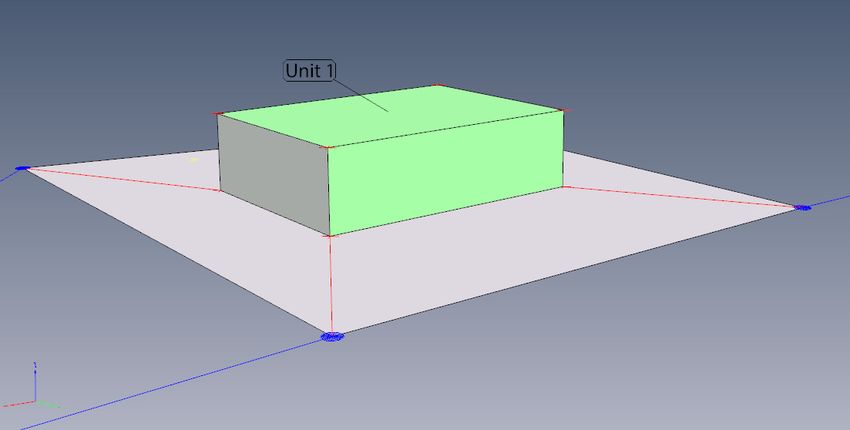
A 3D Digital Cadastre for New Zealand by 2021:
             Leveraging the Current System and Modern Technology

         Trent GULLIVER, Anselm HAANEN and Mark GOODIN, New Zealand

1.    INTRODUCTION

The authors of this paper have been actively promoting the development of a 3D digital
cadastre for New Zealand since 2013. During this time: the status of 3D cadastres
internationally has been examined; dialogue with likeminded international jurisdictions has
taken place; attendance and participation at national and international conferences with a 3D
cadastre flavour has occurred; and input from a practicing licensed cadastral surveyor has
been sought and obtained. Outputs from these undertakings include a thesis, conference
papers and presentations, a New Zealand survey publication article and several internal
discussion documents. Many of these outputs are documented in the References and
Bibliography sections of this paper.

A key finding of the research to-date is the need to develop a system that best accounts for
New Zealand’s situation, for which there are a number of unique characteristics. It is
important to note that this paper is written from the perspective of a regulator. Accordingly
the concepts described in this paper are tied to New Zealand’s cadastral survey system. It is
not the intention of the authors to offer a detailed design solution. Rather the purpose of this
paper is to test theoretical concepts with the international research community and ultimately
with the vendor assigned with the responsibility of building a new land administration system
for New Zealand. As the title of this paper suggests, New Zealand is heading for a fully
operational 3D digital cadastre by 2021. It will be the responsibility of the vendor to realise
the vision for 3D with input of Land Information New Zealand (LINZ) and the surveying
profession of New Zealand.

The following discussion commences with an overview of New Zealand’s cadastral survey
system. This is an important starting point as the system provides both the environment and
platform on which to develop a 3D digital cadastre. With this context the next section
presents an approach to achieve a 3D solution. This is followed by commentary to support
why a 3D digital cadastre will be achieved by 2021. The paper ends with the discussion
packaged into a conclusion.

                                                                                                     474
Trent Gulliver, Anselm Haanen and Mark Goodin
A 3D Digital Cadastre for New Zealand by 2021: Leveraging the Current System and Modern Technology

5th International FIG 3D Cadastre Workshop
18-20 October 2016, Athens, Greece
2. THE CADASTRAL SURVEY SYSTEM IN NEW ZEALAND
The cadastral system in New Zealand is based primarily on boundaries defined by monuments
in the ground. Surveyors measure between monuments and other survey marks, including
geodetic control marks, and record those marks and measurements (bearings and distances) in
a cadastral survey dataset (referred to in New Zealand as a CSD) – formerly a ‘survey plan’.
In New Zealand all cadastral surveys must be undertaken by licensed cadastral surveyors.
Those surveys and the resulting cadastral survey datasets must comply with Rules
(regulations) set by the Surveyor-General (currently the Rules for Cadastral Survey 2010)
before they are lodged with LINZ. LINZ, the government agency responsible for the
cadastral, geodetic and title systems, ensures each cadastral survey dataset complies with the
Rules before approving it and then integrating it into the cadastre.
For 2D surveys the cadastral survey dataset includes all the survey data in structured digital
form (e.g., marks, measurements, boundaries, parcels) as well as a TIFF image (‘plan’) of the
dataset. The system that is used for managing the cadastral survey (and title) information is
called Landonline. Within that system, the dataset components are directly linked to the same
components from previous surveys. For example, it is possible to see the measurements
between two marks from many different surveys.
Integration includes recording all the data in the cadastral survey dataset as lodged by the
surveyor, as well as generating 2D coordinates for all survey and boundary points in terms of
the geodetic control network using least squares adjustments. The coordinates are assigned an
accuracy ‘order’ based on their compliance with the Rules but they do not define the legal
boundaries. Undisturbed marks in the ground and other physical evidence are the primary
means of relocating boundaries. Integration also includes meeting topology requirements to
ensure that there are no gaps or overlaps recorded in the network of ‘primary’ parcels. That
primary parcel network covers all of New Zealand and consists of over 2.5 million parcels
(Landonline interrogation).
Landonline also has a 2D network of ‘secondary’ parcels (e.g., for rights-of-way or other
easements) which are generally related to the corresponding underlying primary parcels. In
this secondary parcel network gaps and overlaps are permitted, although secondary parcels
may not cross a primary parcel boundary.
2.1 The current New Zealand 3D cadastre
New Zealand has a well-established 3D ‘legal’ cadastre. The freehold title system under the
Land Transfer Act 1952 supports rights, restrictions and responsibilities in property,
regardless of whether they are restricted in height or not.
Unit titles (under the Unit Titles Act 2010 - previously the 1972 Act) are the most widely used
form of multi-unit property ownership in New Zealand. At the time of writing this paper
there are in the order of 14,000 residential and commercial unit title developments comprising
around 140,000 unit titles (Landonline interrogation).
475
Trent Gulliver, Anselm Haanen and Mark Goodin
A 3D Digital Cadastre for New Zealand by 2021: Leveraging the Current System and Modern Technology
5th International FIG 3D Cadastre Workshop
18-20 October 2016, Athens, GreeceHowever unlike ‘2D’ cadastral survey datasets (i.e., those which do not contain height
information), the detailed survey information (often both horizontal and vertical) is not
spatially captured in the Landonline system. Rather it is drafted on a plan, with section and
elevation graphics supported by textual descriptions. Height data (e.g., a reduced level) is
included on the plan but is also not captured. These plans can be difficult to interpret,
especially where the boundaries are not uniform. A unit plan is provided as an example in
Appendix A.
2.2 Future goals for the New Zealand 3D cadastre
The aim is for New Zealand’s current 3D cadastre to become fully digital – however, there is
no single, concise definition for what that means internationally (Gulliver, 2015). The
following New Zealand definition for 3D digital cadastre was developed from a modified
definition for cadastre in the Surveyor-General’s cadastral strategy, Cadastre 2034 (LINZ
2014):
the repository of digital cadastral survey datasets, including those with defined 3D
data, and lodged with LINZ and integrated into its database.
(Gulliver, 2015, p. 63)
A 3D digital cadastre would permit data associated with the real world extents of property
rights, restrictions and responsibilities to be digitally captured, automatically checked against
requirements, combined with existing data (and subsequently maintained), and exported for
re-use in other systems.
The primary goal is for the entire cadastral survey process (from ‘field to finish’) to move
away from ‘plans’ and the associated pictorial representation of survey information, and
instead rely on digital data. In this respect New Zealand is already well advanced in relation
to 2D surveys (i.e., those that do not have height information) – but not for 3D.
Cadastral surveyors in New Zealand already utilise digital technologies when undertaking
their surveys, calculations, and verification. They are also obtaining the digital models
generated by architects and engineers for new buildings (e.g., through Building Information
Modelling) and utilise them to define internal boundaries (with ground truthing). However,
the current processes do not allow surveyors to submit that data to the cadastre, but instead
require them to produce a plan image that cannot be interpreted by a computer and which
require human interpretation.
Full digital representation of 3D survey data will maximise quality through digital verification
techniques (e.g., clash detection for 3D boundaries). Visualisation tools offer the opportunity
to significantly improve the quality and interpretation of 3D cadastral survey datasets and the
digital models they contain. Functionality for zooming into a 3D model and changing the
point of view is now readily available (e.g., 3D PDF viewers).
Availability of 3D digital cadastral data will enable it to be presented in various forms and
utilised with other geospatial data for a multitude of purposes – this is routinely undertaken
for 2D cadastral data, but can also be readily achieved for 3D datasets.
476
Trent Gulliver, Anselm Haanen and Mark Goodin
A 3D Digital Cadastre for New Zealand by 2021: Leveraging the Current System and Modern Technology
5th International FIG 3D Cadastre Workshop
18-20 October 2016, Athens, GreeceIt is important to emphasise that while New Zealand currently records many parcels in 2D
format, the associated rights are actually three dimensional – the boundaries extend down into
the ground and up into the air (Figure 1). When creating new rights that are limited in height,
the entire volume in the original right must be addressed and replaced as necessary. Our
conceptual aim is, therefore, to fully integrate 3D ‘parcels’ with the ‘2D’ parcel records and
enable visualisation of both, in 2D and in 3D.
Figure 1. Extents of property rights (Gulliver, 2015, p. 63)
3. APPROACH TO ACHIEVING 3D
3.1 Developing a solution
Solutions need to consider how the extents of 3D property rights, restrictions and
responsibilities are legally defined in a digital environment and also how the related digital
data is incorporated into and managed within the system. New Zealand’s legislative
framework already supports the definition of property rights, restrictions and responsibilities
in 3D and does not inhibit the development of the cadastral survey system to cater for 3D
digital data.
3.1.1 Requirements
Technical and operational changes are required for the cadastre to handle 3D information
digitally. The specific requirements are identified and defined in Table 1.
477
Trent Gulliver, Anselm Haanen and Mark Goodin
A 3D Digital Cadastre for New Zealand by 2021: Leveraging the Current System and Modern Technology
5th International FIG 3D Cadastre Workshop
18-20 October 2016, Athens, GreeceTable 1. Requirements of a 3D digital cadastre (adapted Gulliver, 2015)
Requirement Description
Users will need to be able to visualise, interrogate and extract digital 3D property
Search
rights related information.
Cadastral surveyors will need the ability to digitally capture/lodge 3D cadastral
Capture/Lodgement survey datasets.
Validation Automated business rules will be necessary to check the validity of incoming data.
Integration 3D data will need to be integrated into the cadastre.
The spatial accuracy of the cadastre will require horizontal and vertical network
Maintenance
maintenance.
3.1.2 Establishing an approach
Gulliver (2015) considered Netherland-centric research by Stoter (2004) where three
fundamental interpretations of 3D cadastre are presented: full 3D cadastre, hybrid solution
and 3D tags. The option promoted here for New Zealand is based on a variation on the
concept of ‘hybrid cadastre’. Under this approach 3D property rights, restrictions and
responsibilities can be integrated into the digital cadastre and subsequently maintained. In
situations where the upper and lower height limits of property rights, restrictions and
responsibilities are defined, a full 3D spatial depiction would be used. Otherwise ‘2D’ parcels
would be maintained as a default.
The development of a 3D digital cadastre using a variation of Stoter’s hybrid approach is
deemed to be the most appropriate solution to enhance New Zealand’s cadastral survey
system. This approach builds on the existing robust 2D digital cadastre by allowing 3D data
to be digitally captured, validated, maintained and made available for reuse on an as and
where necessary basis. Importantly the approach also allows New Zealand’s monument and
observation based cadastre (refer to s. 2) to be preserved as the foundation of the digital
cadastre.
3.2 The concept of 3D spatial objects
The concept of a ‘spatial object’ is being considered as an approach to allow parcels defined
in 3D to be submitted and integrated into the digital cadastre and subsequently maintained.
Spatial object modelling is a seasoned tool for use in GIS applications (Molenaar, 1998). In
the context of this paper, a spatial object describes (within specified accuracy standards) the
size, shape and extent of property rights, restrictions and responsibilities - as a 3D polyhedron.
In a GIS context, the spatial object is a coordinated 3D shape – defined in terms of z, y and z.
Modern spatial technologies, including GIS, have functionality for creating, manipulating,
viewing, and managing such spatial objects.
478
Trent Gulliver, Anselm Haanen and Mark Goodin
A 3D Digital Cadastre for New Zealand by 2021: Leveraging the Current System and Modern Technology
5th International FIG 3D Cadastre Workshop
18-20 October 2016, Athens, GreeceFigure 2 (below) is a perspective view of a 3D spatial object representing a secondary right
that is restricted in upper and lower heights located in relation to its underlying primary
parcel.
Figure 2. ‘3D spatial object’ representing a secondary right within a primary parcel
Each spatial object would have a defined relationship to its underlying primary parcel, and
that parcel would have previously been captured and integrated into the 2D digital parcel
fabric.
The approach takes advantage of the fact New Zealand has a mature digital ‘2D’ cadastral
survey system. The use of spatial objects builds on the current system by allowing property
rights, restrictions and responsibilities that are defined in 3D to be digitally incorporated into
the cadastre.
3.3 Creation of spatial object
A spatial object would be based on data collected and verified as correct by the surveyor
responsible for certifying and lodging the cadastral survey dataset. These data may be
obtained through a variety of sources, including architectural and engineering designs,
Building Information Models, and via direct survey measurements made in the field. It is
expected that the latter would also be used to ground-truth each of the preceding scenarios.
As discussed in the previous section, every 3D spatial object is by definition coordinated in
terms of x, y, and z coordinates. In order to have a defined relationship between a spatial
object and its underlying primary parcel, there would be a need to link the spatial object to the
underlying parcel or nearby permanent reference marks (refer to Figure 3).
479
Trent Gulliver, Anselm Haanen and Mark Goodin
A 3D Digital Cadastre for New Zealand by 2021: Leveraging the Current System and Modern Technology
5th International FIG 3D Cadastre Workshop
18-20 October 2016, Athens, GreeceFigure 3. XYZ definitions of ‘3D spatial object’
The following subsections consider the definition of spatial objects for the types of parcel
boundary permitted by the Rules.
3.3.1 3D spatial object for 3D parcel represented by right line, arc, water or irregular
boundaries
From a survey definition perspective, the 3D parcel (a parcel with defined height limits) must
be defined in relation to its underlying primary parcel. This ensures that the boundaries of the
3D parcel could be relocated by firstly relocating boundary points on the underlying primary
parcel which will have been fully defined by monuments.
Similarly, in the cadastral survey dataset, the relationship between the 3D spatial object
(representing a 3D parcel) and its underlying primary parcel needs to be explicitly defined.
This can be achieved by including in the dataset, horizontal coordinates that correspond to
boundary points previously defined on its underlying primary parcel. Wherever the
boundaries of the 3D parcel and the underlying parcel are coincident, the horizontal
coordinates of both ends of the underlying boundary would also need to be included in the
dataset. The accuracy between those coordinated points on the underlying parcel and the
vertices of the spatial object would have to meet the relevant standard in the Rules. These
requirements would also ensure that the spatial object for the 3D parcel could be maintained
in alignment with the primary parcel network.
The vertical position of the 3D parcel needs to be capable of being re-established in the future,
and also reflected spatially in the digital cadastre. Therefore, the ‘z’ vertices inherent in the
3D spatial object would need to be related to ‘z’ coordinates on existing boundary corners of
the underlying primary parcel and/or permanent reference marks, all in terms of the official
vertical datum.
3.3.2 3D spatial object for 3D parcel represented by permanent structure boundaries
The Rules allow certain types of secondary parcels to be defined by permanent structure
boundaries. These boundaries are described in relation to a physical feature (e.g., the outer
480
Trent Gulliver, Anselm Haanen and Mark Goodin
A 3D Digital Cadastre for New Zealand by 2021: Leveraging the Current System and Modern Technology
5th International FIG 3D Cadastre Workshop
18-20 October 2016, Athens, Greeceface of a wall, or an offset to the feature). The licensed cadastral surveyor who certifies the
cadastral survey dataset is responsible for defining the position and accuracy of the permanent
structure boundary in relation to the permanent structure.
Two options have been identified for recording this relationship:
1. Spatial object representation of the permanent structure boundary only. The parcel
and its boundaries would be defined by a 3D spatial object, along with a description of
the physical structure to which it is related and the relationship (e.g., ‘boundary
through centre of wall’ or ‘boundary follows centre of concrete floor’). The
description of the relationship between the permanent structure boundaries and the
permanent structure is of great importance as it defines the legal position of the
boundary.
2. Spatial object representation of the permanent structure boundary and the permanent
structure. The parcel and its boundaries would be defined by a spatial object, as would
the permanent structure itself. The relationship between the two would not necessarily
be required as this would be able to be determined from the spatial objects using a
measurement tool in spatial software. A level of supporting description may still be
required (e.g., ‘internal wall’ or ‘concrete floor’).
Common property, being land or building that is for the use of all the property owners, would
not be defined by a spatial object. That common property will be that part of the total volume
remaining after the 3D spatial objects have been excluded.
The relationship between the 3D spatial object and its underlying primary parcel would also
need to be defined. This could be determined by applying the same principles used for right
line, arc, water or irregular boundaries (as discussed under s. 3.3.1). However, as indicated
earlier, this definition cannot be authoritative as it is the permanent structure boundary that
provides the legal definition of the boundary. Therefore, the spatial position of a 3D spatial
object for a permanent structure boundary would be indicative only in the digital cadastre.
3.4 Validation of spatial object
Data being submitted into the cadastre needs to be validated. The primary purpose of
validation is to ensure that the data complies with the Rules and that it is able to be integrated
into the digital cadastre. Some validation rules that may be required are:
Spatial object is a correctly formed shape and meets the definition of a spatial object
3D spatial object secondary parcel is contained within its primary parcel (this would
require the ability to extrude the horizontal boundaries of the underlying 2D parcel
fabric vertically)
Cadastral survey dataset contains XYZ coordinates for a sufficient number of
underlying primary boundary points and/or permanent reference marks
Spatial object to be checked for collisions with other spatial objects (e.g., parcels for
units).
3D clash detection routines found in current surveying, engineering and GIS software indicate
that validation of 3D spatial objects ought to be readily achieved. Despite any validation
481
Trent Gulliver, Anselm Haanen and Mark Goodin
A 3D Digital Cadastre for New Zealand by 2021: Leveraging the Current System and Modern Technology
5th International FIG 3D Cadastre Workshop
18-20 October 2016, Athens, Greeceprocedures, the responsibility for correctness of certified data will continue to be the
obligation of the surveyor responsible for the cadastral survey dataset.
3.5 Integration of spatial object into digital cadastre
The vision is for a digital cadastre where 3D property rights, restrictions and responsibilities
are represented digitally in 2D or 3D as appropriate in a single integrated and seamless
system.
Once a cadastral survey dataset is approved, it would be adjusted into the digital parcel
network and the representation of the spatial object would be repositioned relative to its
underlying parcel or the permanent reference marks in terms of the official coordinate datum
and projection.
Currently primary and secondary parcels defined by nodes and lines are fully integrated into
the boundary network. This means they are managed topologically and coordinates are
generated through least-squares adjustment of the vector (bearing and distance) data.
However, under this proposal the spatial objects would be managed through a different
process. Topology would not be directly managed, and alignment would be maintained by
applying a transformation to the spatial objects, using the connection points to the cadastral
network as the ‘control’ (i.e., either the boundary points on the underlying parcel or the
permanent reference marks, as recorded in the cadastral survey dataset).
LINZ needs to be able to maintain and update the spatial location of the secondary parcels in
the network over time. Any movement of geodetic marks (such as that caused by tectonic
movements) that affect cadastral marks may have an effect on the underlying parcels which in
turn has an effect on the spatial object. The processes for adjusting the primary parcel network
will need to be extended to also adjust any secondary parcel to keep them in the correct
relationship. The requirement for connections that meet the accuracy standards in the Rules is
intended to ensure that the transformation would result in negligible distortion of the spatial
object during future alignment processes.
Similarly over time, the height values of spatial objects represented in the 3D parcel network
will need to be able to be adjusted as the height values of geodetic control marks change over
time.
3.6 Extracting the data for the spatial object
Exports of the spatial objects for use in other software would be dependent on the user’s
requirement of the data. Two different options for extracting the spatial object would be
available:
1. as transformed to fit the digital cadastre at the time, recognising that positions change
over time due to improved data and geodetic shifts; or
2. as it was lodged, certified and approved in the cadastral survey dataset, as that is the
authoritative record of the legal position of the boundary.
In this latter case the surveyor could then transform that data to fit marks found on the new
survey to accurately determine the location on the ground at that time.
482
Trent Gulliver, Anselm Haanen and Mark Goodin
A 3D Digital Cadastre for New Zealand by 2021: Leveraging the Current System and Modern Technology
5th International FIG 3D Cadastre Workshop
18-20 October 2016, Athens, GreeceSpatial objects would be able to be easily integrated into any GIS or other spatial information
system and overlaid with other datasets. Being coordinated in terms of the official geodetic
datum would enable the boundaries of the primary and secondary parcel (position of the
spatial object) to be readily determined on the ground, especially through the use of
positioning technologies.
3.7 Visualisation of the digital cadastre
It will be important for users to have the ability to become informed of the location and spatial
extents of all property rights, restrictions and responsibilities through visual interrogation and
analysis of the 3D digital cadastre.
3D spatial objects need to be suitably displayed in spatial views in terms of the underlying
primary parcel fabric. In addition to 3D perspective views, 2D plan views could provide for
quick assessment of the ‘footprint’ of all property rights, restrictions and responsibilities in
relation to underlying primary parcels. The user would be alerted to situations where a
‘footprint’ represents a right defined in 3D. 3D views would then be explored if further
understanding was required by the user.
Earlier it was mentioned that there would be a need to vertically extrude the horizontal
boundaries of underlying primary parcels for validation purposes. The ability to extrude such
boundaries would also benefit visualisation. In addition, the draping of the digital cadastre
over a Digital Terrain Model would enable 3D spatial objects to be visualised in the context
of their surrounds (albeit indicatively only).
The ability to visualise a 3D digital cadastre by anyone could be readily achieved, based on
functionality of current surveying, engineering and GIS software, and also 3D PDF viewers.
4. 3D DIGITAL CADASTRE 2021
New Zealand already has a mature 2D digital cadastre that enables the digital lodgement of
2D cadastral survey datasets, and their integration into survey and parcel networks. The
proposals highlighted here are intended to extend this to 3D, but what other contributing
elements exist that make 2021 an achievable target?
4.1 National property rights system
The first element in support is that New Zealand has a national property rights system with
LINZ having sole jurisdiction. Appreciation that this is a contributing aspect is evinced by
the observation made by Karki (2013) that where countries have multiple jurisdictions, each
with their own legislation, systems and practices, this can be seen as an impediment to the
implementation of a national 3D cadastre. Having the one national system also makes it less
problematical to facilitate change, particularly with regard to mandating certain requirements,
if or when they may be considered necessary.
This single jurisdiction model does mean LINZ has the responsibility to continue to enhance
the property rights experience for all users, hence the desire to advance the 3D cadastre. One
483
Trent Gulliver, Anselm Haanen and Mark Goodin
A 3D Digital Cadastre for New Zealand by 2021: Leveraging the Current System and Modern Technology
5th International FIG 3D Cadastre Workshop
18-20 October 2016, Athens, Greeceof the drivers to keep enhancing the system, particularly with respect to digital 3D data,
relates to what other 3D data is being collected and what other applications it is being used
for, by providers other than LINZ. If LINZ is slow to respond to the changing needs and
expectations of society, it is possible that non-authoritative 3D systems may be established to
fill the void, thus creating a competing system to undermine New Zealand’s current property
rights system (Gulliver, 2015).
4.2 Accommodating legislation
As highlighted earlier, New Zealand’s legal cadastre already accommodates 3D property
rights, restrictions and responsibilities. In fact, New Zealand has had a 3D legal cadastre
since the inception of the survey and title systems during the 1800s. The key legislation
relating to New Zealand’s survey and title systems are the Cadastral Survey Act 2002 and
Land Transfer Act 1952 respectively. These acts also do not preclude the development of a
3D digital cadastre to better reflect the legal situation.
4.3 New national vertical datum
A 3D digital cadastre requires national horizontal and vertical datums suitable for cadastral
survey purposes. New Zealand’s current horizontal datum, New Zealand Geodetic Datum
2000 (NZGD2000), covers the country and is sufficient in its current form.
Currently heights recorded in cadastral survey datasets are defined in terms of 13 different
local vertical datums. As of June 2016, New Zealand also has a suitable national vertical
datum, New Zealand Vertical Datum 2016 (NZVD2016). NZVD2016 is the culmination of a
project commenced by LINZ in 2012 to acquire a national airborne gravity dataset. This
allowed a more accurate definition of a reference geoid shape to support survey accurate
elevation determinations across the whole country. NZVD2016 represents a step towards
achieving the primary goal of the New Zealand Positioning Strategy, to “enable the efficient
definition of three-dimensional property rights through an accessible geodetic system” (Land
Information New Zealand, 2014a, p. 6).
4.4 Advanced survey and title services
The most significant development towards New Zealand realising a 3D digital cadastre is the
scheduled replacement of the current survey and title system, Landonline, through a
programme of works known as Advanced Survey and Title Services (ASaTS). In the context
of this discussion, ASaTS provides a pathway to realising a 3D digital cadastre. Importantly,
ASaTS is supported by the New Zealand government.
Landonline is built on technology that was considered to be leading edge in the 1990s.
There have since been substantial advancements in technology, knowledge and expertise in
developing land administration systems. There are also changing expectations by an
increasingly diverse range of customers and consumers that include land professionals, such
as surveyors and conveyancers, along with experts and non-experts in spatial science, systems
and information. These expectations relate to the functionality and performance of the system
and the applications for which its data can be used. In particular there is increasing demand
from the spatial community, and indeed the general public, for 3D property information in a
digital and readily consumable format.
484
Trent Gulliver, Anselm Haanen and Mark Goodin
A 3D Digital Cadastre for New Zealand by 2021: Leveraging the Current System and Modern Technology
5th International FIG 3D Cadastre Workshop
18-20 October 2016, Athens, GreeceA primary objective of ASaTS is to modernise New Zealand’s electronic survey and title
system and provide all users of the system and its data the experience of a better service. It
aims to improve and extend the functionality already offered by Landonline while being a
more interactive, portable and flexible system. The current system uses monolithic IT
architecture which means making changes can be slow and costly to implement. ASaTS will
counter this shortcoming through a modularised IT architecture solution.
LINZ is taking an ‘as a service’ approach to developing ASaTS. Rather than owning the
system, as Landonline currently is, LINZ will select a provider that can deliver a suitable
system that LINZ will pay to use. This concept, which can be likened to renting, is being
used successfully by land administration jurisdictions in Australia and Canada. It is important
to note that while the new system will be owned by another party, LINZ will retain control of
the data and its use. LINZ and its staff will also continue to process and assure the quality of
survey and title transactions.
In April 2016 LINZ released an Expression of Interest document inviting prospective vendors
to register their desire to work with LINZ to deliver the ASaTS solution. LINZ is currently
working with a number of potential vendors and is expecting the successful vendor to be in
place in 2017. Following this, the development of and transition to ASaTS is likely to occur
over a five-year period, with LINZ envisaging the new system to be completely in place by
2021.
5. CONCLUSION
New Zealand is well-placed to design, build and implement a national 3D digital cadastre. A
mature property rights system that already accounts for 3D situations combines with a robust
2D digital cadastre to provide a sound platform on which to realise this objective.
The approach presented by the authors is founded on the belief that the core components of a
3D digital cadastre can be achieved by applying currently available technologies to
New Zealand’s existing system. This approach, which is from the regulatory perspective of
the authors, will need to be tested and refined as necessary. Feedback from the international
research community and the vendor assigned with the task of building the 3D digital cadastre
will be vital in this regard.
Ultimately, New Zealand has the desire, support and means to achieve a 3D digital cadastre
by 2021.
485
Trent Gulliver, Anselm Haanen and Mark Goodin
A 3D Digital Cadastre for New Zealand by 2021: Leveraging the Current System and Modern Technology
5th International FIG 3D Cadastre Workshop
18-20 October 2016, Athens, GreeceREFERENCES
Cadastral Survey Act 2002. New Zealand Government.
Gulliver, T.F.D. (2015). Developing a 3D Digital Cadastral System for New Zealand.
University of Canterbury.
Gulliver, T. (2016). ASaTS and Opportunities for the Cadastral Survey System. Surveying +
Spatial, (86), 35-37.
Gulliver, T. and Haanen, A. (2014). Developing a Three-Dimensional Digital Cadastral
System for New Zealand. Paper presented at the 25th FIG Congress 2014, Kuala Lumpur.
Karki, S. (2013). 3D Cadastre Implementation Issues in Australia. University of Southern
Queensland.
Land Information New Zealand (2014). Cadastre 2034: A 10-20 Year Strategy for developing
the cadastral system. New Zealand Government.
Land Information New Zealand (2014a). New Zealand Positioning Strategy. New Zealand
Government.
Land Transfer Act (1952). New Zealand Government.
Molenaar, M. (1998). An introduction to the theory of spatial object modelling for GIS. CRC
Press.
Office of the Surveyor-General (2014). Position Paper on Smart 3D Cadastre. LINZ internal
document.
Office of the Surveyor-General (2014). Summary Paper on 3D Capable Digital Cadastre.
LINZ internal document.Rules for Cadastral Survey (2010). New Zealand Government.
Office of the Surveyor-General (2016). Discussion Paper on 3D Spatial Object
Representation. LINZ internal document.
Standard for New Zealand Vertical Datum (2016). New Zealand Government.
Stoter, J. (2004). 3D Cadastre. Delft, the Netherlands.
Unit Titles Act (2010). New Zealand Government.
486
Trent Gulliver, Anselm Haanen and Mark Goodin
A 3D Digital Cadastre for New Zealand by 2021: Leveraging the Current System and Modern Technology
5th International FIG 3D Cadastre Workshop
18-20 October 2016, Athens, GreeceAppendix A. Part unit cadastral survey dataset
487
Trent Gulliver, Anselm Haanen and Mark Goodin
A 3D Digital Cadastre for New Zealand by 2021: Leveraging the Current System and Modern Technology
5th International FIG 3D Cadastre Workshop
18-20 October 2016, Athens, GreeceBIOGRAPHICAL NOTES
Trent Gulliver is currently a Senior Survey Advisor with the Office of the Surveyor-General
at Land Information New Zealand. He graduated from the University of Otago School of
Surveying with a Bachelor of Surveying with Honours in 2005 and became a Licensed
Cadastral Surveyor in 2009. In 2016 he graduated with a Master of Geographic Information
Science with Honours, from the University of Canterbury. His thesis, entitled Developing a
3D Digital Cadastral Survey System for New Zealand, has provided a basis from which to
inform the development of a 3D digital cadastre.
Anselm Haanen is currently the New Zealand Deputy Surveyor-General. He holds a Master
of Surveying degree from the University of Otago, obtained registration in 1983 and is a
Licensed Cadastral Surveyor. He has provided advice on Land Information Systems and
spent 2 years in Fiji as Advisor to the Fiji Land Information System. He was also technical
leader in the build of the Landonline survey-accurate cadastral database.
Mark Goodin is currently a Senior Landonline Application Specialist at Land Information
New Zealand. He has spent the majority of his career in the Private Sector operating as a
Licensed Cadastral Surveyor for a multi-disciplinary engineering consultancy. He has
extensive practical experience in 3D digital data capture with specific expertise in carrying
out cadastral surveys involving the definition of 3D property rights, restrictions and
responsibilities.
CONTACTS
Trent Gulliver
Senior Survey Advisor
Land Information New Zealand
PO Box 5501
Wellington 6145
NEW ZEALAND
Phone: +64 4 471 6233
E-mail: tgulliver@linz.govt.nz
Website: www.linz.govt.nz
Anselm Haanen
Deputy Surveyor-General
Land Information New Zealand
PO Box 5501
Wellington 6145
NEW ZEALAND
Tel. +64 4 460 0376
Email: ahaanen@linz.govt.nz
Website: www.linz.govt.nz
488
Trent Gulliver, Anselm Haanen and Mark Goodin
A 3D Digital Cadastre for New Zealand by 2021: Leveraging the Current System and Modern Technology
5th International FIG 3D Cadastre Workshop
18-20 October 2016, Athens, GreeceMark Goodin
Senior Landoline Application Specialist
Land Information New Zealand
PO Box 5501
Wellington 6145
NEW ZEALAND
Phone: +64 4 460 0192
E-mail: mgoodin@linz.govt.nz
Website: www.linz.govt.nz
489
Trent Gulliver, Anselm Haanen and Mark Goodin
A 3D Digital Cadastre for New Zealand by 2021: Leveraging the Current System and Modern Technology
5th International FIG 3D Cadastre Workshop
18-20 October 2016, Athens, Greece490 Trent Gulliver, Anselm Haanen and Mark Goodin A 3D Digital Cadastre for New Zealand by 2021: Leveraging the Current System and Modern Technology 5th International FIG 3D Cadastre Workshop 18-20 October 2016, Athens, Greece
You can also read