Design and Access Statement - Land at Scarrowscant Lane Haverfordwest Pembrokeshire SA61 1EP - Pembrokeshire County Council
←
→
Page content transcription
If your browser does not render page correctly, please read the page content below
Design and Access Statement
Land at Scarrowscant Lane
Haverfordwest
Pembrokeshire
SA61 1EP

                            Persimmon Homes
                            December 2018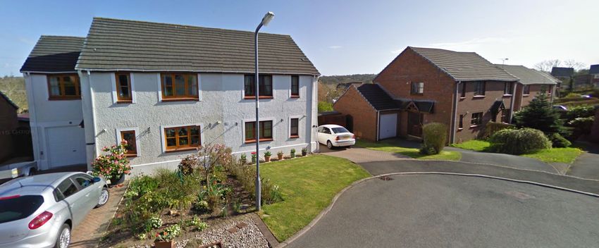
Contents

         Design and Access Statement
         Land at Scarrowscant Lane
         Haverfordwest
         Pembrokeshire
         SA61 1EP

1.0 Introduction         6.0 Character
2.0 Policy Context       7.0 Community Safety
3.0 Site Context         8.0 Environmental Sustainability
4.0 Design Development   9.0 Movement
5.0 Access               10.0 Conclusion

                                                            2
1.0 Introduction
1.1 Background
This Design & Access Statement (DAS) has been prepared by Persimmon Homes West Wales in
support of a full application for residential development relating to Land at Scarrowscant
Lane, Haverfordwest, Pembrokeshire, SA61 1EP in accordance with the requirements and
recommendations of Technical Advice Note (TAN) 12: Design.

The application site measures 4.73 hectares and the proposal comprises the development of
179 dwellings including a mixture of 1, 2, 3 and 4 bedroom dwellings from our Persimmon range
of housetypes.

The application is accompanied by a full suite of plans, drawings and supporting
documentation including a report detailing the Pre-Application Consultation exercise
undertaken.

1.2 Location

The site is located in the south west of the settlement of Haverfordwest, the county town and
most populous urban area in Pembrokeshire. This market town provides an important road
network hub between Milford Haven, Pembroke Dock, Fishguard and St David's as a result of
its position at the tidal limit of the Western Cleddau.

The majority of the town, comprising the old parishes of St. Mary, St. Martin and St. Thomas, lies
on the right (west) bank of the river. On the left bank are the suburbs of Prendergast and
Cartlett.

The site itself is bordered by hedgerows and trees with denser copses along the Scarrowscant
Lane frontage either side of the former Glenover House/Redhill Preparatory School.

There are a group of derelict buildings towards the north western boundary.

                                                                                                     Images: Application Site and Housetypes
                                                                                                                                               3
1.0 Introduction
1.3 Planning History
The site is allocated for residential development, under reference number HSG/040/00106, in
the Pembrokeshire County Council Local Development Plan (adopted 2013). It has been
allocated for an indicative number of 140 dwellings, although this does not represent an upper
limit for the site.

The planning application history for the site comprises the granting of Outline planning
permission in February 2008 under planning application reference 05/0530/PA. A subsequent
Section 73 application, requesting the extension of time to submit the relevant Reserved
Matters, was also granted by Pembrokeshire County Council under application reference
11/0506/PA.                                                                                      Images: Approved Illustrative Layout (above) and
                                                                                                 Pre-application Block Plan (below)

1.4 Pre-Application Discussions
The application was subject to pre-application discussions with Pembrokeshire County Council
Planning and Highways Officers.

With regard to the layout, the feedback was positive with the provision of on-site Public Open
Space confirmed based on the Authority’s adopted Planning Obligations Supplementary
Planning Guidance.

                                                                                                                                                    4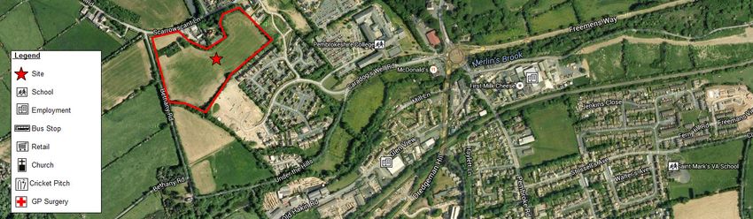
2.0 Policy Context 2.1 Planning Policy Wales Welsh Government planning policy is contained within Planning Policy Wales Edition 10 which was published in December 2018. Paragraph 3.3 sets out how, ‘Good design is fundamental to creating sustainable places where people want to live, work and socialise. Design is not just about the architecture of a building but the relationship between all elements of the natural and built environment and between people and places. To achieve sustainable development, design must go beyond aesthetics and include the social, economic, environmental, cultural aspects of the development, including how space is used, how buildings and the public realm support this use, as well as its construction, operation, management and its relationship with the surrounding area’. 2.2 Technical Advice Note 12: Design The Welsh Government updated Technical Advice Note (TAN) 12: Design in 2014. It advocates a process model for design drawing from a contextual analysis of the surroundings of a development to achieve a well designed, flexible and adaptable development. The key aspects are: Access; Character (Amount, Layout, Scale, Appearance, Landscaping); Community Safety; Environmental Sustainability; and Movement. It also identifies the objectives of good design as: Ensuring ease of access for all; Sustaining or enhancing local character; Promoting legible development; Promoting successful relations between public and private space; Promoting quality, choice and variety; Promoting innovative design; Ensuring attractive, safe public spaces; Security through natural surveillance; Achieving efficient use and protection of natural resources; Enhancing biodiversity; Designing for change; and 5 Promoting sustainable means of travel.
2.0 Policy Context
2.3 Adopted Local Development Plan

Pembrokeshire County Council (PCC) adopted their Local Development Plan (LDP) in February
2013. Whilst the Authority has commenced the statutory Review process, this ‘2006-2021’
document will remain as the development plan until such time that a replacement Plan is
adopted.

The proposed development site lies within the defined settlement boundary of Haverfordwest
and is allocated in Pembrokeshire County Council’s (PCC) Local Development Plan (LDP)
under Policy GN27 - Residential Allocations as site HSG/040/00106 for a minimum of 140 units
and to indicatively to provide 25% affordable housing on-site.

Other policies applicable to the proposed development include SP1 - Sustainable
Development; SP7 - Housing Requirement; SP8 - Affordable Housing Target; GN1 - General
development Policy; GN2 - Sustainable Design; GN26 - Residential Development; GN27 -
Residential Allocations; and GN28 - Local needs Affordable Housing. It should be noted that
this scheme is also be supported by a Planning Statement, which provides a robust justification
of the proposal against adopted planningt policy.

2.4 Supplementary Planning Guidance

The proposed development has also taken into consideration Pembrokeshire County Council’s
adopted Supplementary Planning Guidance on Open Space, Affordable Housing, Parking
Standards and Planning Obligations.

                                                                                                  6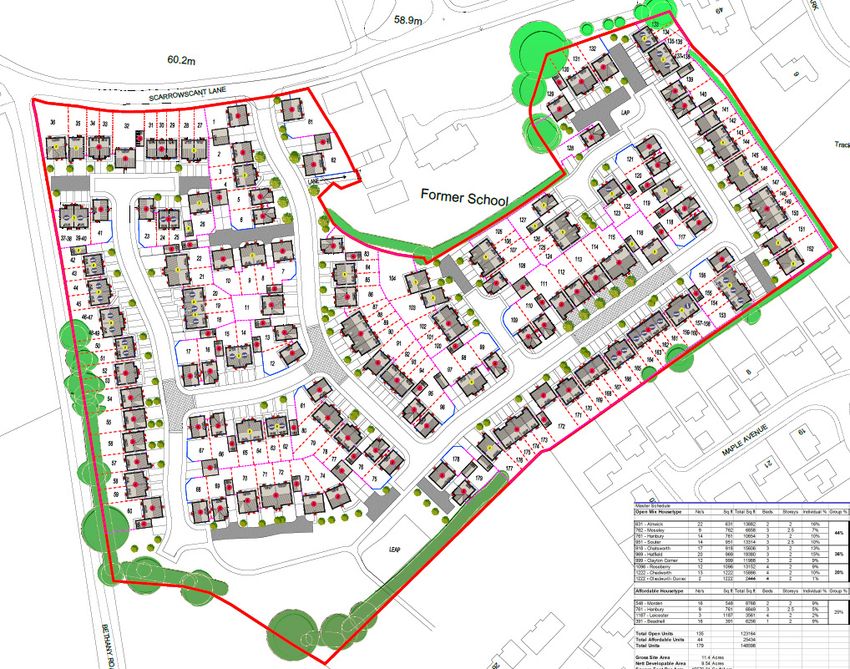
3.0 Site Context
3.1 Physical Context

A number of visits have been undertaken and a selection of photographs of the site are               1                                           2
provided opposite.

The application site consists of an irregular shaped parcel of land located to the south of
Scarrowscant Lane. It falls generally in a southerly direction, allowing for longer views into
the site from the south, and is bordered to the east and south by existing residential
dwellings and to the west by Bethany Road and open countryside.

The site forms the remaining land of the Glenover Fields housing estate to the south and is          3                                           4
bordered by hedgerows and trees with denser copses along the Scarrowscant Lane
frontage, either side of the former Glenover House/Redhill Preparatory School.

The proposed development has been carefully designed to ensure the retention of as
many of the trees and hedgerows that border the site as possible.

There are no Public Rights of Way that cross the proposed development site.
                                                                                                     5                                           6

Vehicular access will be gained from the north via Scarrowscant Lane .

                                                                                                                              1       2

                                                                                                                          3

                                                                                                                                  4              5

                                                                                                                                          6

                                                                                                 Images: Application site and Site Photographs
                                                                                                                                                     7
3.0 Site Context
3.2 Character Appraisal - General
The area surrounding the proposed development is a mixture of existing residential
development and open countryside. This section of the DAS seeks to detail the different           1
character areas surrounding the site.

To the north of the proposed development is Scarrowscant Lane (Photo 1) which
comprises a mixture of brick, render and pebbledash bungalows set back from the road
with parking to the front and side and enclosed front gardens.

To the south of the site is Glenfields Road (Photos 2-5) and Maple Avenue (Photos 6-7)
which comprises a mixture of newer traditional 2 storey detached and semi-detached                2
properties finished in red or yellow brick with white upvc windows and doors although
there are some bungalows and white render dwellings on Maple Avenue and the
dwellings have brown upvc windows and doors. There is a combination of on-plot parking                                     3
to the front and side with some garages integrated into the house and other set back
behind the building line. The front gardens, where provided, are not enclosed.
                                                                                                  4
The former Glenover House/Redhill Preparatory School (Photo 8) is a 2.5 storey building
with gables and rooms in the roof finished in brick and pebbledash with some mock-Tudor
detailing on the gables.

As illustrated by the photographs opposite, the existing residential development within
the vicinity of the proposed development site is mainly characterised by the vernacular of
the era in which it was built. The development of this area of Haverfordwest cannot be            6
said to have consistently followed any particular architectural style, although the urban
                                                                                                                           5
form is, generally, detached and semi-detached built to a medium to high density.
Furthermore, the scale is predominantly two storey although there are some bungalows
on Maple Avenue and Scarrowscant Lane.

                                                                                                  7                        8

                                                                                             Images: Nearby developments
                                                                                                                               8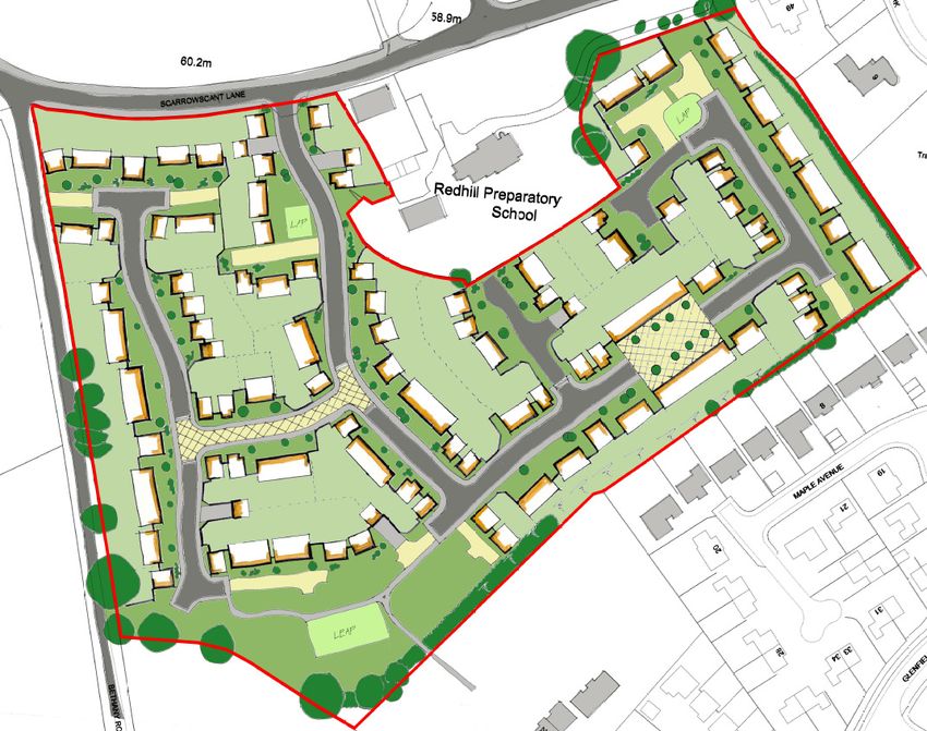
3.0 Site Context
3.2 Character Appraisal (cont.)
On-plot car parking is commonly provided to the front or side with garages either
integrated or set behind the building line.

The detailing and materials used are a combination of brick, render and pebbledash. The
roofs are predominantly hipped with some gabled creating interest in the street scene.
Windows and doors are mainly upvc and some dwellings have porches. The majority of
dwellings in this area are set back form the highway, although some dwellings do front
directly onto the pavement. Some front gardens are enclosed by dwarf walling
although, as illustrated in the photographs, many are open plan in nature.

The following pages seek to assess each of the identified character areas in more detail.
The relative location of these areas is illustrated on the map opposite and described as
follows:

1.Merlins Bridge
2.Albert Town and Surrounding Area
3.Slade Residential Area
4.Town Centre

                                                                                            Images: Character Areas
                                                                                                                      9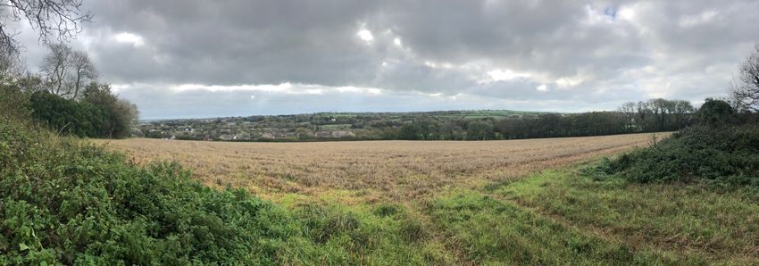
3.0 Site Context
3.2.1 Character Appraisal – Merlin’s Bridge Area

West of Area 1
A relatively undulating area comprising mainly detached and semi-detached dwellings.
The residential estate developed to the south east of the application site is accessed via
Glenfields Road and is characterised by a variety of finishing materials. The most recently
developed houses are predominantly red brick. This area is located in close proximity to
Pembrokeshire college – an educational institution for 14 -19 year old students in full and
part time education.

Southern Residential Areas
A mixture of Semi detached and detached housing of mainly painted and brick finishes.
Many of the larger detached houses in this area benefit from significant front parking
areas and gardens

The residential areas directly south of the A4076 are typically more dated and include
semi detached bungalows and terraced housing. The houses here often lack off-street
parking facilities.

                                                                                              Images: Merlin’s Bridge Area
                                                                                                                             10
3.0 Site Context
3.2.2 Character Appraisal – Albert Town and Surrounding Area
This character area surrounds the B4341 highway which provides access to Haverfordwest
from the west.
In the centre of Albert Town the residential area is largely comprised of terraced housing.
Detached bungalows and larger 3-4 bedroom detached houses front on to the B4341 in
the west of the area. Some of these houses are set back significantly from roads to
provide substantial gardens and space for parking.
The east of the area is dominated by commercial buildings that neighbour the Tasker
Milward VC school. Housing is terraced with painted roughcast finishes in a variety of
colours.
Images: Albert Town and Surrounding Area
113.0 Site Context
3.2.3 Character Appraisal –Slade Residential Area
A mixture of apartment block buildings and small terraced plots are found in the Slade
residential area. The area is located in the northern section of Haverfordwest.
Flats are typically 2 bedroom whereas larger plots are mainly 3 bedroom.
Large communal green areas with play areas separate apartment blocks and housing
terraces.
Differs significantly from the more recent developments on Slade Lane such as the
Cashfield estate.
Images: Slade Residential Area
123.0 Site Context
3.2.4 Character Appraisal - Town Centre
In the north of character area 4 lies Haverfordwest’s 12th Century castle and associated
museum.
The centre possesses a pedestrianised area surrounded by a variety of high street shops.
The most modern commercial and residential development lies on the banks of the
Western Cleddau River which flows from north to south.
Housing in the town centre is confined to high density terraced units with limited front
garden space and a distinct lack of off-street parking.
To the south lies a residential area where house types include both detached bungalow
dwellings and terraced blocks. These dwellings are typically south facing and overlook
the A4076.
The southernmost parts of the area are dominated by red brick bungalows and terraces.
As distance towards the town centre increases, terraced units become dominant with
cheaper roughcast finishes that expand the range of house prices in the area.
Images: Town Centre
133.0 Site Context
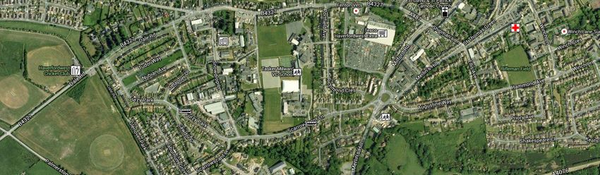
3.3 Local Facilities
Within the vicinity of the site there a number of local facilities and amenities available to
future residents as identified below in more detail and on the aerial photograph overleaf.
Tesco Extra is less than 2km north east of the proposed development site and there are a
number of other small shops and industrial units providing both employment and products
for sale to the public within the vicinity of the site.
There are also a number of schools within walking and cycling distance of the
development site, including Tasker Milward School and Pembrokeshire College.
There will be one LEAP and one LAP provided on-site to serve the proposed
development.
The nearest bus stops are less than 500m from the proposed development on Furzy Park to
the west and Scarrowscant Lane to the east.
The nearest medical facilities are available at St Thomas Green less than 1.5km north east
of the site.
Images: Local Facilities
143.0 Site Context
3.3 Local Facilities
Image: Local Facilities
153.0 Site Context
3.4 Social and Economic Impact
This development has been designed to:
Contribute significantly to the range and type of house types available in the local
area; and
Address shortfalls in essential local services and facilities such as education.
In addition, the development will provide the following social and economic benefits:
A massive boost to the local economy through the construction industry and its
multiplier effect. That is, for every £1 spent on housing £3 goes back into the
economy and that each home built creates 1.5 full time direct jobs. It is also
estimated that at least twice that number of jobs is created in the supply chain.
(Source: HBF Briefing: The Growth and Infrastructure Bill—Second Reading (October
2012))
Furthermore, the scheme will be subject to a Section 106 legal agreement providing
affordable housing as well as likely financial contributions towards local facilities including:
Also the scheme is subject to a Section 106 legal agreement, where any heads of terms
will seek to provide:
• Affordable housing on site;
• a financial contribution towards highway improvements in the area;
• the provision of one LAP and one LEAP on-site
• an off-site contribution towards the provision of a NEAP in the area.
•Education contribution
•Community Facilities contribution
•Library contribution
Image: HBF Briefing
164.0 Design Development
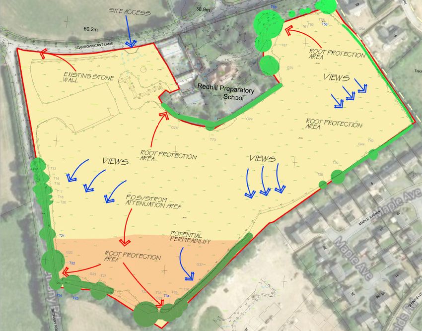
4.1 Opportunities and Constraints
The following opportunities are identified as part of the proposed development:
•Providing permeability to the existing residential dwellings to the south on
Glenfields Road;
•Retaining the existing hedgerows and trees wherever possible;
•Orientating dwellings to make the most of the views from the site southwards;
•Providing on-site areas of public open space;
•Providing a good mix of 2 & 2.5 storey 1, 2, 3 and 4 bed dwellings including some
affordable; and
•Facilitating the housing requirement in the local area.
The constraints of the proposed development regarding its surroundings include:
•The presence of root protection areas; and
•The requirement to provide an area for attenuation which can also be used as
public open space.
Image: Existing Site Opportunities and Constraints
174.0 Design Development
4.2 Principles
The key principles of the overall development have shaped the design process from the
outset. They play a key role in everything from the overall layout to the final surface
materials. The core principles and how they are addressed are set out below:
Connectivity and Permeability
The site bordered to the north and west by Scarrowscant Lane and Bethany Road and to
the east and south by existing residential development and so needs to represent a well
designed expansion to the existing residential development. Furthermore, the layout of
the proposed development has full regard to the principles of inclusive design and
ensures the highest standards of accessibility and permeability through the creation of
pedestrian and vehicular networks through the site.
Marketability of the Site
It’s crucial that the site begins to contribute to the housing supply in the area as soon as
possible. As a result, the house type mix and range is an important aspect that has been
fully incorporated into the design with the site providing a number of 1, 2, 3 and 4 bed
dwellings some of which will be affordable and all of which will have sufficient parking
and amenity space.
Provision of Well Designed, Managed and Maintained Public Open Space
The proposed development incorporates one no LAP and one LEAP on site which will add
to the provision of recreational open space in the local area. As a result, the design
needs to ensure that the Public Open Space created improves both the quality and
quantity of open space for the local area.
Sensitively Designed Edges.
The development site is located close to existing residential properties, and as such the
interaction between existing and proposed dwellings needs to ensure that amenity levels
are not detrimentally affected. This can be achieved through appropriate boundary
treatments and generous stand-off distances.
Images: Approved Indicative Layout and Pre-
18
Application Block Plan4.0 Design Development
4.3 Design Evolution
Based on the ‘Site Context’ as well as the ‘Opportunity & Constraints Plan’ and the
‘Principles’ established earlier in this chapter, a basic block structure for the site was
progressed towards a detailed Site Layout Plan for submission.
The proposed development has established a block structure with corridors of movement
and outward facing development with a street hierarchy reducing from 1.8m wide
footways on both sides to 1m wide footways leading to private drives.
A strong building line is proposed along the new spine roads that will serve the proposed
development and there are areas with outward facing properties providing overlooking
towards the areas of public open space.
The plot configurations are ‘family-friendly’ as they deliver a combination of on-plot
parking to the front or side, a regular shaped front garden and generous garden space
to the rear of the properties.
Furthermore, the mix of housetypes helps create a more interesting street scene by
providing a mix of 2 & 2.5 storey dwellings allowing some of the dwellings ‘kiss-the-kerb’
with parking, and detached garages where applicable, to the side whilst others are set
back with parking to the front such as those with integrated garages.
The movement framework for the proposed development ensures both pedestrian and
vehicular links to the existing network including Scarrowscant Lane and Glenfields Road.
Images: Proposed Layout Plan
195.0 Access
5.1 Car Parking
All car parking spaces will be located within the curtilage of each dwelling where possible
or within 15m of the nearest accessible entrance in accordance with general planning
guidance and where driveways provide the main route to the principle access, they will
allow adequate space for all users to make their way past parked cars in accordance
with Approved Document Part M of the Building Regulations.
5.2 Pathways
Where applicable, highway footpaths will be a min. of 1800mm for adopted roads and
will be continuous with no obstructions and regular resting places a max. of 50m apart
and in clear view of one another while private roads will have a small 900mm min.
pathway strip to border the dwellings and 1200mm to the entrances. Any street furniture
will be off the access route and in a contrasting colour and the edges of paths will be
clearly defined using tactile paving or raised kerbs with a maximum gradient of 1:12
where appropriate. Any drainage grating along paths will be flush with the surrounding
paving materials with slots no more than 13mm wide set at right angles to the dominant
direction of travel. Any circular holes will be no more than 18mm wide.
5.3 Entrance and Circulation
The following features will be provided in line with Part M:
•Dwelling entrances will be highly visible and well lit at night with no discrimination in terms
of access;
•Where applicable, ramped approaches to dwellings will be a minimum of 1.2m wide with
a max. gradient of 1:20 and with a flat platform measuring 1.2m by 1.2m at the top and
bottom;
•All principal entrance doors will have a minimum clear opening width of 0.775m to allow
access to the dwelling for wheelchair users;
•The ground floor of each dwelling has been designed to provide ground floor
accommodation, including accessible WC, if required in the future;
•Suitable corridor and door widths;
•Suitable stairs to first floor; and
•Accessible switches and sockets.
Images: Access, circulation and parking
206.0 Character
6.1 Amount
The proposed development comprises 179no. Residential units comprising a mix of 2, 3
and 4no. bedroom dwellings.
The mix offers a wide range of properties including starter, mid-market and larger family
homes. Furthermore, the different styles allow for the creation of well designed street
scenes throughout the development.
A mix of open-market and affordable units (44no. units at a rate of 25%) are proposed,
with the location of the affordable units broadly illustrated on the image opposite.
Car parking provision is in keeping with Pembrokeshire County Council’s adopted Parking
Standards. The Standards state that the maximum parking provision would be and a
maximum of 3no. spaces per dwelling. It should be noted that the Standards also provide
sustainability criteria that would allow a reduction in parking provision across the site.
However, this proposal seeks to provide the maximum quantum of off street parking
wherever possible, despite benefiting from sufficient sustainability points to allow a
reduction.
Images: Proposed Site Layout by Tenure
216.0 Character
6.2 Layout
The layout has been designed to create a high quality environment and townscape that
integrates the development within its landscape by ensuring that the land use and
pattern of development is well spaced within the site creating a practical and efficient
street hierarchy; providing effective amenity space (utilising natural landscaping); and
providing a strong building line and frontage to the roadside.
The following design principles have been adhered to, which are borne out of the site
appraisal and design development detailed earlier in this document.
Generous stand-off distances to protect residential amenity - These distances have
been provided to ensure that the development does not have a materially adverse
impact upon existing neighbouring residents.
Outward facing development to create a defined street scene - Properties front on
to streets in order to create a sense of place and to maximise natural surveillance.
The properties near the southern boundary have also been designed to make the
most of the long views out of the site and to overlook the Public Open Space.
Strong urban block structure - This is well defined and creates an efficient layout
which minimises ‘dead’ space.
New footways integrated into the development - Connectivity to nearby facilities
and non-vehicular routes are strengthened.
Car parking integrated into the development - Provision is in keeping with Councils
Parking Standards.
Natural surveillance of public open space - The Public Open Space areas will be
well overlooked by the proposed units in line with safety and security principles.
To this end, given the policy context provided by the Adopted Local Development Plan;
the nature of surrounding land uses and constraints; as well as the general location, a
traditional two/two and a half storey scheme would represent a sustainable development
solution for this site.
Images: Proposed Site Layout
226.0 Character
6.3 Scale
The site is adjacent to existing residential dwellings and so provides an opportunity to
provide additional 2 and 2.5 storey homes in keeping with the surrounding area.
The massing of the development has also been designed to integrate with its surroundings
with houses of around the same height preventing unwanted juxtapositions both within
the site and with the neighbouring residential area.
Furthermore, the slight variations in height between the units have been used to
punctuate key areas such as overlooking the Public Open Space and key junctions within
the proposed development.
Careful consideration of the existing approved building line and the desire for natural
frontage results in a development that also promotes a sense of architectural continuity.
Properties with rooms in the roof have been incorporated into the proposed development
in order to provide interest in the street scene.
As a result, the design demonstrates that it is possible to provide a solution that not only
responds to its context but which, as any contemporary development should, establishes
its own sense of place by embodying sound principles of urban design including
appropriate scale, proportions and rhythm to the street scene.
The following Persimmon Homes housetypes are proposed from our Persimmon Range:
1 Bed – Beadnell (16 Affordable)
2 Bed – Alnwick (x22)and Morden (x16 Affordable)
3 Bed – Mosely (9), Hanbury (14 + 9 Affordable), Souter (14), Chatsworth (17), Hatfield (20),
Clayton Corner (12)
4 Bed – Roseberry (12), Chedworth (13), Chedworth Corner (2) and Leicester (3
Affordable)
23
Images: Selection of Housetype CGIs6.0 Character
6.4 Appearance
The architectural design has been informed by the character assessment carried out on
the existing residential dwellings within the vicinity of the site and so incorporates details
and material choices inspired by neighbouring properties including:
•Persimmon facing brick (mix of Anston Red and Langold Buff);
•Marley Modern Smooth Grey Roof Tiles with Smooth Grey ridge tile.
•Pitched roofs with gables to the front on some house types;
•Restrained detailing
•A combination of on-plot parking to the front and side with integrated or detached
garages;
•Upvc windows;
•IG Composite Doors;
•Pitched and gabled porches;
•1.8m high brick screen walls with pillars and infill fencing;
•1.8m high hit and miss fence along the rear boundary of plots and 1.2m high post and
two rail fence along the side boundaries between plots; and
•Tarmac roads , footways, drives and parking spaces and concrete paving slabs for
private footpaths.
The material palette has been designed to compliment the vernacular of the local area
and will be locally sourced where possible. It will also help to create a sense of place
based to improve site legibility and create diversity.
Images: Materials
246.0 Character
6.5 Landscaping
The proposed development shows some indicative planting across the development and
the retention of the majority of trees and hedgerows that form the boundary of the site.
Planting will be used to break up the frontage parking where necessary through the
planting of street trees, hedges and low level shrubbery all of which will also provide
defensible space and make a distinction between public and private space.
The existing hedgerows and trees along the boundaries will be retained with new planting
proposed in and around the area of public open space.
A detailed Landscaping Plan has been prepared to support the application.
Images: Layout Plan – Indicative Landscaping
257.0 Community Safety
7.1 Secured by Design
Secured by Design (SBD) is a police initiative to guide and encourage those engaged
within the specification, design and build of new homes to adopt crime prevention
measures in new development. The SBD principles that have been considered as part of
the proposed development ensure maximum security and safety by analysing the layout
and access to and from roads, parking areas, footpaths and communal areas; boundary
treatments and landscaping; the layout and orientation of dwellings; the type and
location of lighting; and the physical security of the dwellings themselves, i.e. the security
of doors, windows, conservatories etc.
7.2 Boundary Treatments
The new dwellings strongly define the boundary of the site and so anyone entering would
be immediately noticeable. Furthermore, each dwelling will be divided with a 1.8m high
hit and miss fence to the rear and post and two rail fence to the side boundaries
between plots. Although, a 1.8m high brick screen walls with pillars and infill fence panels
will be provided for rear and side boundaries that are prominent in the public realm.
7.3 Surveillance
Natural surveillance is provided by the orientation of the dwellings as the front doors are
clearly legible and the living spaces face onto the main access and car parking areas.
The joining of private driveways/pathways and the general openness of the design also
gives way to a natural deterrent of good sightlines/observation of the public domain.
7.4 Ownership and Responsibility
The sense of community already in the area along with the provision of defensible space
in the form of private driveways, front gardens and good natural surveillance will
promote a sense of ownership to the residents of the dwellings. This will help to ensure that
everyone takes responsibility for the safety and upkeep of the development (see the Site
Layout Plan for details relating to the proposed boundaries).
Images: Layout Plan
268.0 Environmental Sustainability
8.1 Sustainable Design Standards
The proposed development has been designed with sustainability in mind and is an
important consideration of the overall development.
The proposed development is for residential dwellings within Haverfordwest and, as
previously outlined, this is considered to be a sustainable location with access to retail,
education, recreational space, employment opportunities and public transport.
The Welsh Minister for Housing and Regeneration announced major changes to the
national planning policy requirements for sustainable building standards following
changes to Part L (relating to energy efficiency) of the Building Regulations which came
into force on the 31st July 2014.
The primary reason for this change is that the Building Regulations provides a more
appropriate vehicle for setting building standards. As such, there has been an
amendment to TAN 12 (Design) and TAN 22 (Planning for Sustainable Buildings) has been
revoked and practice Guidance on Planning for Sustainable Buildings issued instead.
As a result, the Code for Sustainable Homes is no longer applicable.
Nevertheless, the proposed development will comprise energy efficient dwellings
through a variety of techniques including enhancing the building’s fabric and utilising
energy efficient technologies.
Images: Layout Plan
279.0 Movement
Town Centres Work/School Elsewhere
9.1 Walking Desireable 200m 500m 400m
Manual for Streets defines a ‘Walkable Neighbourhood’ as 800m whilst walking distances
Acceptable 400m 1000m 800m
for pedestrians without mobility impairment as stated in the Institution of Highways and
Transportation (IHT) Guidelines for Providing for Journeys on Foot (2000) is up to 2km as Preferred Max. 800m 2000m 1200m
summarised below. IHT Walking Distances
As illustrated by the isochrone map opposite, there are numerous schools, shops,
employment, leisure and entertainment facilities within the recommended walking
distance of the site including Merlin’s Bridge and the majority of Haverfordwest centre
including Dew Street, High Street, Market Street and Upper Market Street.
9.2 Cycling
The closest cycle route to the site is National Cycle Route 4 which is a long distance route
between London and Fishguard via Reading, Bath, Bristol, Newport, Swansea,
Carmarthen, Tenby, Haverfordwest and St. Davids. It runs along Bethany Road which
forms the western boundary of the proposed development site.
5km is considered a reasonable cycling distance for the journey to work and, as a result,
2km
within the recommended cycling distance of the site (15-20 minutes), there are numerous
schools, shops, employment, leisure and entertainment facilities including Merlin’s Bridge,
Haverfordwest and a number of outlying villages surrounding Haverfordwest
5km
Images: IHT Walking Distances and 2km Walking
28
and 5km Cycling Isochrone Map9.0 Movement
9.3 Public Transport
The nearest bus stops are less than 500m from the proposed development on Furzy Park
to the west and Scarrowscant Lane to the east. The bus stops are served by the 301/304
Haverfordwest Town Circular which connects the site with Haverfordwest and Withybush
Hospital and the T5 Traws Cambria which connects Haverfordwest with Aberystwyth via
Fishguard, Cardigan, Newquay and Aberaeron.
The nearest train station to the site is Haverfordwest approximately 2.5km north east of the
site. The station is operated by Arriva Trains Wales and is on the South Wales mainline
which connects Milford Haven with Carmarthen, Swansea, Cardiff and London.
9.4 Vehicular
The site will be accessed off Scarrowscant Lane.
Scarrowscant Lane connects to Merlin’s Hill to the east and the A4076 Freemens Way
which in turn connects to Cambrian Place and the A40 Narberth Road. The A40 connects
Haverfordwest with Figuard to the north and St Clears and Carmarthen to the west before
it turns into the A48 and then J49 of the M4.
Merlin’s Hill also connects to the A4076 to Milford Haven at Dredgeman Hill.
A full Transport Impact Assessment was submitted in support of the Section 73 application
11/0506/PA for 150 dwellings which concluded that no highway mitigation measures
would be necessary but that the performance of the Merlin’s Bridge Signals should be
monitored.
However, as part of this full application, the TIA has been undertaken by Corun to reflect
the uplift in the number of units.
Images: 301 and 304 Bus Route and Local Highway
29
Network Map10.0 Conclusion
10.0 Conclusion
This Design & Access Statement has been prepared by Persimmon Homes in support of a
full planning application for 179 dwellings on land off Scarrowscant Lane, Haverfordwest.
This Design and Access Statement shows that the proposed development meets the
objectives of good design as set out in TAN 12 because:
•The accessibility of the site ensures access for all by meeting the relevant policies
and regulations with regard to car parking, pathways, entrances and circulation
and future adaptability.
•The amount, layout, scale, appearance and landscaping of the proposed
development are all in keeping with the character of the surrounding area.
•The proposed development is legible, links public and private space ensuring that
both are attractive and safe and promotes quality, choice and variety through
innovative design.
•In terms of community safety, the proposed development includes secured by
design principles, acceptable boundary treatments and natural surveillance as
well as the ability to promote ownership and responsibility.
•The proposed development is environmentally sustainable in that it meets the
relevant sustainable design standards required of it, achieves efficient use and
protection of natural resources and enhances biodiversity.
•There are numerous facilities and amenities within walking and cycling distance of
the proposed development. It is also well served by public transport and meets the
Council’s parking guidelines.
30You can also read