MOTIVATIONAL MEMORANDUM - Nali ...
←
→
Page content transcription
If your browser does not render page correctly, please read the page content below
MOTIVATIONAL MEMORANDUM

MOTIVATION IN SUPPORT OF AN APPLICATION IN TERMS OF SECTION
16(1) OF THE CITY OF TSHWANE LAND USE MANAGEMENT BY-LAW,
2016 FOR THE REZONING OF -

ERF 2212, ERASMIA

REPARED FOR:               FARHAO OMAR ISMAIL PROPERTY TRUST

BY:                        THE TOWN PLANNING HUB CC

 Tel: (012) 809 2229
 E-mail: bea@tph.co.za

 PO Box 11437
 Silver Lakes
 0054

 Lombardy Corporate Park
 Block B / Unit 13
 Cole Road
 Shere
 0084
PAGE 2 OF 21

                                           INDEX

1.       THE APPLICATION

2.       GENERAL INFORMATION
        2.1       Local Authority
        2.2       Property Description
        2.3       Registered Owner
        2.4       Property Size
        2.5       Locality
        2.6       Existing Zoning
        2.7       Existing Land Use
        2.8       Deed of Transfer
        2.9       Bond

3.       MOTIVATION
        3.1      Background
        3.2      Immediate area / surroundings
        3.3      Need and Desirability
                 3.3.1 Spatial Planning and Land Use Management Act, Act 16 of 2013 (SPLUMA)
                 3.3.2 Gauteng Spatial Development Framework, 2030 (GSDF)
                 3.3.3 Tshwane Integrated Development Plan, 2017/21
                 3.3.4 City of Tshwane Metropolitan Spatial Development Framework, 2012
                 3.3.5 Regionalized Municipal Spatial Development Framework, 2018: Region 4
                        (RMSDF)

4.       DEVELOPMENT PROPOSAL

5.       ENGINEERING SERVICES
         5.1      Roads & Stormwater
         5.2      Water & Sanitation
         5.3      Electricity
6.       DOLOMITE STABILITY INVESTIGATION

7.       FEASIBILITY INVESTIGATION

8.      CONCLUSION

TPH20408/ERASMIA/REZONING                                        THE TOWN PLANNING HUB CC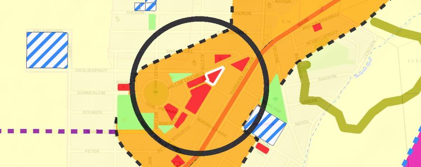
PAGE 3 OF 21
MOTIVATION IN SUPPORT OF AN APPLICATION IN TERMS OF SECTION 16(1) OF
THE CITY OF TSHWANE LAND USE MANAGEMENT BY-LAW, 2016 FOR THE
REZONING OF ERF 2212, ERASMIA
1. THE APPLICATION
Application is made in terms of Section 16(1) of the City of Tshwane Land Use Management By-
Law, 2016 for the rezoning of Erf 2212, ERASMIA from “Business 1” to “Business 1” including
the rights for a filling station and car wash as well as an increase in coverage from 30% to 40%.
2. GENERAL INFORMATION
2.1 Local Authority
City of Tshwane Metropolitan Municipality.
2.2 Property Description
Erf 2212, Erasmia.
2.3 Registered Owner
The property is registered in the name of Farhad Omar Ismail Property Trust.
2.4 Property Size
The property measures 5 554m² in extent.
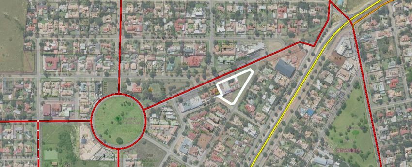
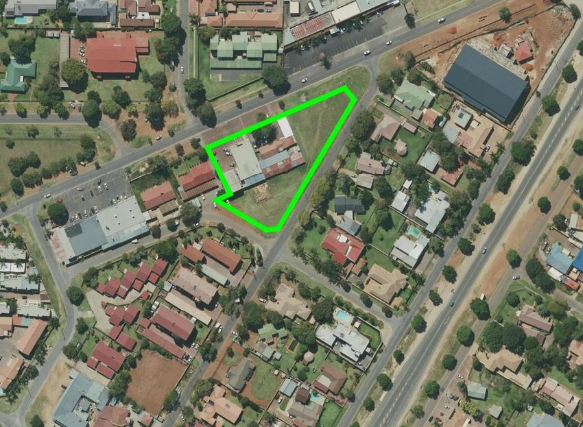
2.5 Locality
The property is situated at 361 Willem Erasmus Street. Please refer to the aerial image
below.
TPH20408/ERASMIA/REZONING THE TOWN PLANNING HUB CC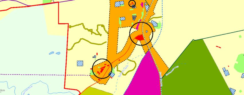
PAGE 4 OF 21

2.6      Existing Zoning

         The property is zoned “Business 1”. Refer to the attached Zoning Certificate.

2.7      Existing Land Use

        There are existing buildings / businesses on site.

2.8     Deed of Transfer

         The property is registered under Certificate of Consolidated Title T105532/2004.

2.9      Bond

        The property is not bonded by any financial institution.

3.       MOTIVATION
3.1      Background

         The owner wishes to obtain the rights to develop a filling station and associated land uses.

         From there this application.

TPH20408/ERASMIA/REZONING                                                 THE TOWN PLANNING HUB CC
PAGE 5 OF 21

3.2      Immediate area / surroundings

         The application site is situated in a well-established neighbourhood and within a local node in
         terms of the Regionalised Metropolitan Spatial Development Framework.

         The area is mixed use in nature (residential, businesses and social services).

         Kindly refer to the land use plan attached.

3.3      Need and Desirability

         The need to encourage and support infill development within the City of Tshwane cannot be
         questioned. As the application site falls within a node the need for infill development is even
         more prominent and desired. This is also indicated in the Regionalized Municipal Spatial
         Development Framework, 2018 (Region 4) for the area –

                            “A node is a place where both public and private investment
                            tends to concentrate. Nodes are usually associated with major
                            road intersections, or with public transport nodes such as
                            railway stations and taxi ranks. It offers the opportunity to
                            locate a range of activities, from small to large enterprises and
                            is often associated with mixed-use development including high
                            density residential uses. Nodes differ in size, the types of
                            activity that occur within them, the size of the areas served and
                            the significance within the city.” Page v/vi

         The City of Tshwane is thus under constant pressure for development and private investment in
         certain areas. In the past decade the City of Tshwane’s Spatial Development Framework’s have
         been transformed into what we see today as well planned neighbourhoods and/or nodes that will
         be sustainable in the long run.

         Densification is also a development principle that guides development in majority of South African
         cities, in order to more effectively provide services and utilise existing service infrastructure to its
         full potential, lower development costs and to reduce urban sprawl.

         But with densification comes the need to provided ancillary services to the community, one of
         which is additional filling stations where needed.

         The onus lies with the Municipality to ensure that –

                             “…municipal planning finds applicability in development that
                            is co-ordinated and harmonious in such a way as to most
                            effectively tend to promote the health, safety, good order,
                            amenity, convenience and general welfare of the area in which
                            the scheme is proposed as well as efficiency and economy in

TPH20408/ERASMIA/REZONING                                                      THE TOWN PLANNING HUB CC
PAGE 6 OF 21
the process of such development.” (Section 9(1)(b) of the City
of Tshwane Land Use Management By-Law, 2016).
It is motivated and supported in this motivating memorandum that the implementation of this
development will adhere to the above section of the By-Law. The proposed use will ease the
lives of everyday citizens of the city that will reside in the area, with easy access to amenities
and social infrastructure.
The application will be further motivated against the following policy documentation;
Spatial Planning and Land Use Management Act, Act 16 of 2013
Gauteng Spatial Development Framework, 2030
Tshwane Integrated Development Plan, 2017 - 2021
City of Tshwane Metropolitan Spatial Development Framework, 2012
Regionalized Municipal Spatial Development Framework 2018, Region 4
3.3.1 Spatial Planning and Land Use Management Act, Act 16 of 2013 (SPLUMA)
The recent introduction of the SPLUMA requires for all land development applications to comply
and be motivated in accordance with same.
This application complies with the objectives and development principles of SPLUMA which will
be elaborated on further below.
Section 7
7. The following principles apply to spatial planning, land development and land use
management:
(a) The Principle of spatial justice, whereby –
(i) Past spatial and other development imbalances must be redressed through
improved access to and use of land;
(ii) Spatial development frameworks and policies at all spheres of government
must address the inclusion of persons and areas that were previously
excluded, with an emphasis on informal settlements, former homeland
areas and areas characterised by widespread poverty and deprivation;
(iii) Spatial planning mechanisms, including land use schemes, must
incorporate provisions that enable redress in access to land by
disadvantages communities and persons;
(iv) Land use management systems must include all areas of a municipality
and specifically include provisions that are flexible and appropriate for the
management of disadvantaged areas, informal settlements and former
homeland areas;
TPH20408/ERASMIA/REZONING THE TOWN PLANNING HUB CCPAGE 7 OF 21
(v) Land development procedures must include provisions that accommodate
access to secure tenure and the incremental upgrading of informal areas;
and
(vi) A Municipal Planning Tribunal considering an application before it may not
be impeded or restricted in the exercise of its discretion solely on the
ground that the value of land of property is affected by the outcome of the
application;
This application is for the rezoning of the application site to include the rights to develop a filling
station and associated / ancillary land uses. It will thus not be required to address the
aforementioned principle; however, all other sections are adhered to. The approval of this
application will indicate the support of the City of Tshwane towards planning practices that support
the need to be more flexible and inclusionary.
(b) The principle of spatial sustainability, whereby spatial planning and land use
management systems must –
(i) Promote land development that is within the fiscal, institutional and
administrative means of the Republic;
(ii) Ensure that special consideration is given to the protection of prime and
unique agricultural land;
(iii) Uphold consistency of land use measures in accordance with
environmental management instruments;
(iv) Promote and stimulate the effective and equitable functioning of land
markets;
(v) Consider all current and future costs to all parties for the provision of
infrastructure and social services in land developments;
(vi) Promote land development in locations that are sustainable and limit
urban sprawl; and
(vii) Result in communities that are viable;
This application complies with the above principle. The site is not viable agricultural land in any
form, will support the functioning of land markets in the area and the owner intends to pay the
required contribution amounts for services infrastructure upgrades. The application does not
result in urban sprawl and will result in a more viable community.
(c) The principle of efficiency, whereby –
(i) Land development optimises the use of existing resources and
infrastructure;
(ii) Decision-making procedures are designed to minimise negative financial,
social, economic or environmental impacts; and
(iii) Development application procedures are efficient and streamlined and
timeframes are adhered to by all parties;
This application complies with the above principle, specifically the optimal use of existing services
infrastructure. The owner wishes to finalise the application timeously and the construction of the
filling station as soon as possible.
TPH20408/ERASMIA/REZONING THE TOWN PLANNING HUB CCPAGE 8 OF 21
(d) The principle of spatial resilience, whereby flexibility in spatial plans, policies and
land use management systems are accommodated to ensure sustainable
livelihoods in communities most likely to suffer the impacts of economic and
environmental shocks; and
The Regionalized Municipal Spatial Development Frameworks available to applicants allow for
the change in land use and densities within the City of Tshwane, allowing for applications such
as these. Although the site does not fall within an environmentally sensitive area, its support will
allow for sound economic affairs in the city.
(e) The principle of good administration, whereby –
(i) All spheres of government ensure an integrated approach to land use and
land development that is guided by the spatial planning and land use
management systems embodied in this Act;
(ii) All government departments must provide their sector inputs and comply
with any prescribed requirements during the preparation or amendment
of spatial development frameworks;
(iii) The requirements of any law relating to land development frameworks;
(iv) The preparation and amendment of spatial plans, policies, land use
schemes as well as procedures for development applications, include
transparent processes of public participation that afford all parties the
opportunity to provide inputs on matters affecting them; and
(v) Policies, legislation and procedures must be clearly set in order to inform
and empower members of the public.
This application complies with the above principle; the development conforms to the applicable
earmarked land uses as provided for in the Regionalized Municipal Spatial Development
Framework, as will be discussed under point 3.3.5. All the required internal departments will
have the opportunity to provide comments on the application.
Section 42
42.(1) In considering and deciding an application a Municipal Planning Tribunal must-
(c) (i) the public interest;
(ii) the constitutional and transformation imperatives and the related
duties of the State;
(iii) the facts and circumstances relevant to the application;
(iv) the respective rights and obligations of all those affected;
(v) the state and impact of engineering services, social infrastructure
and open space requirements; and
(vi) the effect of the land development application on the environment.
Public interest:
The public interest will be addressed as a service will be provided to the public within a
node, surrounded by other social services such as, a church and a police station.
TPH20408/ERASMIA/REZONING THE TOWN PLANNING HUB CCPAGE 9 OF 21
Constitutional and transformation imperatives and the related duties of the State:
The application has no bearing on the State.
Facts and circumstances relevant to the application:
The application is located in an established neighbourhood and within a local node. The
property has obtained business rights many years ago, the intention of this application is
to include the rights of a filling station and related / ancillary uses.
Respective rights and obligation of all those affected:
The application will be duly advertised and anyone aggrieved by the application will be
allowed the opportunity to give their input thereto.
State and impact of engineering services, social infrastructure and open space
requirements:
The engineering services will not be negatively affected. The existing services
infrastructure is already in place, the additional capacity will be determined by the services
departments and will require the payment of bulk contribution fees, which the owner
intends to pay and upgrade in order to positively contribute to the city infrastructure. The
existing services will thus be optimised.
The effect of the land development application on the environment:
This point can be seen as omissible as the application site is situated within a built-up area
and no sensitive environmental areas will be affected. The registered land owner will
further comply with the requirements of GDARD.
In general, the rights of the surrounding property owners will be taken into account. The required
advertising will take place timeously together with the site notices to be placed on the property.
The required registered letters will be sent out to the surrounding property owners where after
our office will remain open for any discussion and input from the affected parties in terms of
development controls and design of the buildings.
The application will promote health, safety, order, amenity, convenience and welfare of the area.
The application site will result in more ‘eyes on the street’, a new modern building to be built that
complies with all health and safety requirements. The market value of the property as well as the
surrounding properties will increase due to private investment in the area, supported by the local
authority.
3.3.2 Gauteng Spatial Development Framework, 2030 (GSDF)
The Gauteng Spatial Development Framework, 2030 has been adopted and is a development
tool that proposed to align development, not only within the City of Tshwane but across the
Province.
“The Gauteng Spatial Development Framework (GSDF) 2011
was the first attempt at an integrated, coherent vision of
TPH20408/ERASMIA/REZONING THE TOWN PLANNING HUB CCPAGE 10 OF 21
settlement form, transportation and economic development for
the province. However, it was not implemented as intended,
resulting in a slow pace of spatial, economic and social
transformation in the province. In 2015, the Gauteng Provincial
Government decided to review the GSDF 2011, a decision that
was also prompted by the Spatial Planning and Land Use
Management Act (SPLUMA) (Act 16 of 2013), which came into
force on 1 July 2015. This resulted in the GSDF 2030, which
seeks to (i) direct, guide, focus and (ii) align, coordinate and
harmonise all development spending in the province, to ensure
rapid, sustainable and inclusive provincial economic growth
and township redevelopment, therefore enabling decisive
spatial transformation.” Page viii, GSDF 2030
“The Spatial Development Vision
The Gauteng of 2030 is an integrated, connected space that
provides for the needs of all who are born in or drawn to the
province. Economic growth is spread widely, beyond the core
areas, to nodes and multi-modal activity corridors. These
nodes and corridors provide safe, high-intensity and high-
density mixed land-use settlements, where the young and old
are able to walk, cycle and relax in public spaces. A range of
public transport modes ensures affordable, province-wide
interconnectedness and access to the full spectrum of
economic, cultural and educational opportunities, placing the
province on a far more sustainable growth trajectory. …” Page
ix, GSDF 2030
In order to make the above spatial vision a reality, various spatial development principles were
identified of which one is that of ‘concentration’ and the subsequent need to increase economic
development / potential in the city.
“To realise the spatial development vision, all developments in
the province need to adhere to six spatial development
principles: (i) liveability, (ii) concentration, (iii) connectivity, (iv)
conservation, (v) diversity, and (vi) viability.” Page ix, GSDF
2030
This application supports the vision by conforming to the development principles, ie:
Liveability: The proposed development is creating opportunities for people to be part of a
well-established neighbourhood that is centred around educational, work and
social / economic opportunities that are easily accessible.
TPH20408/ERASMIA/REZONING THE TOWN PLANNING HUB CCPAGE 11 OF 21
Concentration: With the increase in density of people into an area the need for additional filling
stations increases.
Connectivity: The proposed filling station will not have a major influence on the connectivity
aspect.
Conservation: The application site is not prone to any protected fauna and flora. A
Environmental Specialist is appointed to apply for the necessary Envrionmenal
Authorisation, this will be sent to the Municipality as soon as same is received.
Diversity: The area in itself is diverse in characteristic and falls within the Erasmia Node.
Viability: The proposed development will be viable, as a service will be provided that will
be beneficial to the community.
In short it can be concluded that the Gauteng Spatial Development Framework of 2030 has very
strong views on sustainability of the cities located in the province, where these developments’
intention should be to create a more sustainable and integrated Gauteng City Region.
In general, the application site conforms to the vision and principles set out in the policy document.
Not only will the Municipality not have to provide additional services and infrastructure due to
independent investment in the area, the application is to increase accessibility to the area to a
filling station and related uses.
3.3.3 Tshwane Integrated Development Plan, 2017/21
The vision for the City of Tshwane has been relooked and adapted over recent years –
“A prosperous capital city through fairness, freedom and
opportunity.
Strategy implementation towards achieving the new vision for
2030 is anchored around service delivery excellence and
innovation; growing the economy and creating jobs;
promoting a safe and healthy city; promoting social cohesion,
inclusion and diversity; and fostering participation,
collaboration and diversity.” Page 4, IDP 2017/21
In order for the City to achieve their vision (ie, a capital city through fairness, freedom and
opportunity), the City has several strategic development pillars, which guide development, these
are as follows:
“A City that facilitates economic growth and job
creation
A City that cares for residents and promotes
inclusivity
A City that delivers excellent services and protects
the environment
TPH20408/ERASMIA/REZONING THE TOWN PLANNING HUB CCPAGE 12 OF 21
A City that keeps residents safe
A City that is open, honest and responsive.”
Pages 7 & 33, IDP 2017/21
Each of the aforementioned pillars has certain priorities that the City has identified and
undertakes to uphold. These priorities need to be realised. Only priorities that are relevant to
this application will be discussed below:
Pillar 1: A City that facilitates economic growth and job creation
“As for Pillar 1, the City undertakes to –
attract investment and encourage growth by making
it easy to do business in Tshwane;
revitalise and support Tshwane’s entrepreneurs;
empower individuals to take advantage of
opportunity;
catalyse infrastructure-led growth and revitalise
existing nodal economies; and
encouraging tourism and recreation.” Page 35
The approval of the application will contribute to the City’s economic growth as additional rates
and taxes will be payable on the property. The area is an attractive investment area as a private
ownership and development is being pursued and in essence allowing individuals to take
“advantage” of what will work best in both their interest as well as the Municipality’s interest.
Pillar 3: A city that delivers excellent services and protects the environment
“The pillar covers the following priorities:
Delivering high-quality services; and
Safeguarding water and energy resources and
protecting the natural environment.” Page 43
In order to assist the Municipality with delivering high-quality services, it is important to note that
although the area and specifically the application site has previously been serviced, the
infrastructure gets old and/or overloaded, unfortunately the Municipality cannot carry these costs
alone and this is where private investment into the City assists by either bulk contributions and
/or upgrading of the services.
Pillar 5: A City that is open, honest and responsive
“The pillar covers the following priorities:
Building a capable city government;
Fighting corruption; and
TPH20408/ERASMIA/REZONING THE TOWN PLANNING HUB CCPAGE 13 OF 21
Communicating regularly and effectively with
residents.” Page 47
By way of the Municipality establishing a capable government, this includes all Departments
within the Municipality, the finalisation of land use applications, service level agreements,
clearance certificates etc can be completed timeously, this will save land owners / developers
unnecessary fees and will in turn generate economic growth for the Municipality.
This development will enhance growth of the City of Tshwane’s economy as follows:
- Job opportunities will be created;
- The Municipality will receive a higher income from the services and property tax;
- The development will boost the Tshwane economy;
- The site will be utilised more efficiently and economically; and
- The current infrastructure of this area will be enhanced and more people will have easy
access to basic needs and social infrastructure to support their day to day needs.
This application complies with the spatial planning vision of the IDP for the City of Tshwane.
3.3.4 City of Tshwane Metropolitan Spatial Development Framework, 2012
”Spatial Vision
A Spatially Efficient Capital City that is Sustainable,
Competitive and Resilient:
Sustainability: Optimising the use of land through
densification, infill and consolidation, resulting in a city with
spatially integrated equal opportunities, correcting spatial
imbalances, creating sustainable settlements and advancing
social equity.“ Page 45, MSDF 2012
The spatial directive above will be achieved by this development through the locality of the
development. It is spatially sound in the sense that it is within the Erasmia Node as well as the
emerging node located to the East (Cnr R55 and Main Road).
“It is imperative that available infrastructure within the nodes
are used optimally. This requires densification and
intensification of land uses through compaction and infill
developments.” Page 58, MSDF 2012
TPH20408/ERASMIA/REZONING THE TOWN PLANNING HUB CCPAGE 14 OF 21
“Densification goes hand-in-hand with this approach to
intensification and is also structured around the Metropolitan
Activity Areas, Corridors and Activity Spines. The purpose of
such higher density residential development is to provide
residential opportunities in environments that are high-
intensity, mixed use, pedestrian friendly and supported by
public transport where a number of economic and social
opportunities are available within a relatively compact
geographical area.” Page 60, MSDF 2012
This application fully complies with the above directives of the MSDF as the application will result
in a more compact urban form through densification of land that is located close to existing
services infrastructure that will be optimally used, social amenities such as schools, business and
entertainment areas.
3.3.5 Regionalized Municipal Spatial Development Framework, 2018: Region 4 (RMSDF)
“The RSDF will focus on spatial transformation, Economic
transformation and Ecological transformation as envisioned
in the Roadmap towards Tshwane 2030. The approved IDP
contain the strategic context within which the 2017/21 IDP
has been developed and contain five strategic pillars which
is guiding the focus for the 5 year term.
The five pillars as indicated in the Roadmap towards
Tshwane 2030 can be summarised as follows:
1. A City that facilitates economic growth and job
creation
2. A City that cares for residents and promotes
inclusivity
3. A City that delivers excellent services and protects
the environment
4. A City that keeps residents safe
5. A City that is open, honest and responsive.” Page
11
By way of approval of the application the City will be upholding their vision, the approval will
provide economic opportunities that are being provided for in a node, the approval will
strengthen the existing node.
TPH20408/ERASMIA/REZONING THE TOWN PLANNING HUB CCPAGE 15 OF 21
“During 2011, a new Emerging Node situated at the
intersection of the R55 and Main Road (K103) to the east of
Erasmia, known as Erasmia Extension 15, was approved.
This emerging node will be developed as a regional retail
centre as well as various other mixed land uses such as
wholesale trade, warehouses, motor related uses, etc.”
Page 37
Existing Node
Emerging Node
Application Site
Existing Node
“The RSDF indicates a number of nodes (either existing or
emerging) which are important on a regional and local level.
The extension of existing, well located nodes should however
be encouraged before the creation of new nodes. As in the
case of existing nodes, it is proposed that higher density
residential uses be introduced as part of the node. It should
also include social and community facilities.” Page 49
From the above extract of the RMSDF there are a number of nodes within the Erasmia area.
Rather than urban sprawl, this application is applying for additional rights on an already zoned
property within an existing node. The proposed land use will create jobs, not only during the
construction phase(s) but daily jobs as well.
“The trend for new development is integrated development
nodes which include various land uses and emphasize the
need to incorporate job opportunities close to residential
development.” Page 37
The existing node, in which the application site is situated within, includes social services, ie the
SAPS Erasmia.
TPH20408/ERASMIA/REZONING THE TOWN PLANNING HUB CCPAGE 16 OF 21
“Densification and infill are sound urban development
principles to pursue, but caution should be issued that most
existing developed areas were not planned to accommodate
higher densities and that in general the present road
infrastructure cannot accommodate the additional traffic that
densification implies. Densification should therefore be
approached holistically striving to also support a better public
transportation system as a dual development process.” Page
17
The proposed filling station will provide an economic boost for the area and will not generate
additional traffic to the area. The application site is easily accessible via Willem Erasmus Street.
Main Road is a north-south distributor and runs one block removed to the east.
Collector Road (non-residential)
(Willem Erasmus Street)
Metropolitan Distributor
(Main Road)
Application Site (
TPH20408/ERASMIA/REZONING THE TOWN PLANNING HUB CCPAGE 17 OF 21
4. DEVELOPMENT PROPOSAL
The following development controls are proposed:
Zoning: “Business 1” including a filling station and car wash
Coverage: 40%
Height: 2 Storeys
FAR: 0.35
The intention is to incorporate a filling station and car wash into the existing “Business 1” rights
as well as to increase the coverage from 30% to 40%.
5. ENGINEERING SERVICES
Engineers have been appointed to investigate the services for the proposed land use. These
reports will briefly be discussed below, the full reports are however attached to the submission.
5.1 Roads & Stormwater
PBE Consutling Structural & Civil Engineers were appointed to compile a Services
Report, as mentioned above the report is attached hereto, however will be discussed
below:
The report indicates that 60 hourly trips are to be generated and that a traffic impact
study must be conducted to confirm any road upgrades. We are however of the opinion
(as stated within the Feasibility Study) that a filling station is not a trip generator. It must
further be borne in mind that there are existing rights on the property, the FAR is not
being increased.
There is an existing 450mmø installed along Petrus Myburgh Street with kerb inlets
located at the southernmost and lowest corner of the site. It is proposed that the internal
stormwater will be routed so that it is discharged into a catch-pit on the southern corner.
The catch-pit will drain into a new 450ø Class 50D pipe.
5.2 Water & Sanitation
PBE Consutling Structural & Civil Engineers were appointed to compile a Services
Report, as mentioned above the report is attached hereto, however will be discussed
below:
Water:
TPH20408/ERASMIA/REZONING THE TOWN PLANNING HUB CCPAGE 18 OF 21
There is an existing 75mmø pipe instaled Willem Erasmus Street along the northern
boundary. An upgrade of the 170m long section of the 75mmø AC water pipe along
Willem Erasmus Street is proposed. The 75mmø should be replaced with a new
110mmø uPVC pipe between the section of the existing 100mmø pipe.
Sewer:
There is an existing 150mmø clay pipeline that is installed inside a 3m wide servitude
traversing the site. A further 150mmø clay pipeline along Petrus Myburgh Street
termintates at a manhole on the southern most corner of the site.
A new 160mmø connection is proposed at the lowest position, in the southern-most
corner.
5.3 Electricity
IngPlan Consutling Engineers (Pty) Ltd were appointed to compile a Services Report,
as mentioned above the report is attached hereto, however will be discussed below:
After coordination with council, it was found that the nearest point of tie in will be at the
Aletta minisub switching station in Aletta Road where a MV cable will be used to cut into
the network at the switching station and run to the proposed new development.
At the boundary of the new development, a new 315kVA Minisub will be placed and a
Low Voltage connection will be received from the LV side of the minisub to a 3 door
metering kiosk to be placed on the erf boundary.
6. DOLOMITE STABILITY INVESTIGATION
J Louis van Rooy was appointed to investigate and compile a Dolomite Stability Investigation.
This report is attached hereto, however will be briefly discussed below:
The report compiled by J Louis van Rooy includes a previous investigation done by RMS in
2005. The reason being that the report by RMS only covered a portion of the site. This report
which includes the finding of RMS covers the entire site.
The site is located in an established residential area that is serviced by the usual municipal
services including storm water reticulation.
“The site-specific geological model indicates a typical sequence of transported and residual chert
covering the stand with the deeper vertical profile comprising of residual dolomite, fractured
dolomite and fresh dolomite bedrock. Horizon thicknesses varies significantly and indicates
variable bedrock surface across the stand. Fresh bedrock typically occurs between 7 m and 19
m and no groundwater was encountered in the zone above the bedrock or within the upper 25 m
of the profile.
TPH20408/ERASMIA/REZONING THE TOWN PLANNING HUB CCPAGE 19 OF 21
Air and sample losses occurred in only BH1 between 4 – 7 m where some penetration resistance
was still recorded.
Penetration times typically increase from approximately 20 sec/m in the overburden to 1 min/m
in the weathered and fractured bedrock to more than 3 min/m in the fresh dolomite.”
“HYDROGEOLOGY
No specific groundwater strikes were recorded by the driller and no water level was measured in
any of the boreholes after 24 hours standing time.
The permanent groundwater level is at 45 m from levels recorded in proximate boreholes. The
groundwater is therefore at significant depth below the dolomite bedrock surface.
This is supported by the published dolomite compartment and groundwater maps (DWAF, 2009)
with the stand being located in the Centurion Groundwater Basin in which long-term water level
measurements show the average depth of the groundwater to be at more than 30 m.”
“The Inherent Hazard Class based on the above for Stand 2212, Erasmia can be zoned into a
northern part with IHC 5 and a southern part with IHC 6 (Figure 4 and Table 4, Appendix E) for
conditions where groundwater ingress is the main mobilizing agency and dewatering will only
lead to the lowering of groundwater levels within the dolomite bedrock (IHC //1). The northern
part may therefore be regarded as having a high risk for the development of sinkholes with an
expected diameter of less than 2 m and the southern part has a high risk of sinkholes with
diameters of less than 5 m developing.”
“APPROPRIATE LAND-USE RECOMMENDATIONS
The proposed development on this stand is for filling station, car wash and small retail units and
typically falls into the C3 Designation of SANS 1936-1, Table 2 (Appendix E).
According to SANS 1936-1 Table 2 (Appendix A) the proposed commercial development in an
area with IHC 5 or IHC 6 will be permissible if the foundation and precautionary measures
assigned to the dolomite area designation D3 are applied. The present drilling programme is
regarded as sufficient to also include the footprint investigation requirement with boreholes BH3
and BH4 proximate to the filling station, BH6 and BH7 proximate to the shops and BH1 near the
car wash area. The remaining area will be utilised as parking areas (C8).”
The Engineering Geologist has proposed Foundation Measures which will be adhered to by the
client.
7. FEASIBILITY INVESTIGATION
A feasibility study was compiled by Civil Concepts Consulting Civil and Structural Engineers.
The report is attached hereto however will be briefly discussed below.
“This report analysed the feasibility of a proposed filling station to be located along Willem
Erasmus Street, on stand 2212, Erasmia 350-JR, Pretoria. Calculations indicate that the
proposed development site is expected to pump out approximately 222 148 litres of fuel per
TPH20408/ERASMIA/REZONING THE TOWN PLANNING HUB CCPAGE 20 OF 21
month in its first year (2020), based on passing traffic volumes and the average fill per vehicle of
its nearby competitors.
The proposed filling station development will be serviced by two (2) accesses; a proposed full
access off Willem Erasmus Street and a proposed full access off Petrus Myburgh Street.
The effect that the proposed filling station will have on the four (4) existing filling stations within
a 3.5 km radius were considered. It was found that only one (1) of the four (4) existing filling
stations could be considered as a competitor site, since it will share some of passing traffic on
the same routes. The other three (3) filling stations will share a negligible volume of traffic with
the proposed filling station because traffic will have to divert from their intended origin-destination
to access the proposed filling station.
The proposed filling station will not generate new trips, as in general a filling station is
not a trip generator. *
The average fill per vehicle, facilities provided and current monthly sales at the various filling
station sites within a 3.5 km radius were surveyed on 27 May 2019. It has been determined that
the proposed filling station may have an average fill of approximately 25 litres per vehicle based
on the survey conducted.” * applicants own underlining and bolding.
The proposed filling station will be serviced by two access, a proposed full access off Willem
Erasmus Street and a proposed full access off Petrus Myburg Street.
There are four (4) sites were surveyed within a 3.5km radius:
1. Engen Easy Service Station – 3.05km north of the application site
The site is located in Laudium along Jewel Street, which has one access point off Jewel
Street. The site is not considered a competitor site due to location.
2. Engen Solly Kharbai Motors Service Station – 3.10km north of the application site
The site is located in Laudium and lies in the south-western quadrant of Jewel Street
and 2nd Avenue. The site has two access points. The site is not considered a competitor
site due to location.
3. Shell Service Station – 3.55km north of the application site
The site is located in Laudium and lies in the north-eastern quadrant of 41st Avenue and
Bengal Street. The site has two full access. The site is not considered a competitor site
due to location.
4. Caltex Service Station – 0.3km east of the application site
The site lies in the south-western quadrant of Main Road and Helena Street in Erasmia.
The filling station has two accesses. The site has good visibility and accessibility. The
TPH20408/ERASMIA/REZONING THE TOWN PLANNING HUB CCPAGE 21 OF 21
filling station mainly intercepts passing vehicles along Main Road. This site is
considered as a competitor site.
The conclusion of the Feasibility Study recommends that a filling station be developed on the
site.
8. CONCLUSION
Application is made in terms of Section 16(1) of the City of Tshwane Land Use Management By-
Law, 2016 for the rezoning of Erf 2212, ERASMIA from “Business 1” to “Business 1” including
the rights for a filling station and car wash as well as an increase in coverage from 30% to 40%.
The aim of the application, as mentioned and motivated within this memorandum is to incorporate
a filling station and car wash into the existing “Business 1” rights.
The proposed development will not detrimentally affect anyone’s health but will promote good
order and better security in the area. It will promote the amenity, convenience and general welfare
in the area to no expense of the people in the area.
The Municipality’s approval of this application will be appreciated.
TPH20408/ERASMIA/REZONING THE TOWN PLANNING HUB CCYou can also read