PROPOSED NEW FUEL STATION DEVELOPMENT FEASIBILITY STUDY - REMAINDER ERF 38333 RICHMOND BUSINESS PARK, MILNERTON
←
→
Page content transcription
If your browser does not render page correctly, please read the page content below
REMAINDER
                    ERF 38333 RICHMOND
                    BUSINESS PARK, MILNERTON

PROPOSED NEW FUEL STATION

DEVELOPMENT             BY NGOVU WANAWAKE

FEASIBILITY STUDY                 April 2021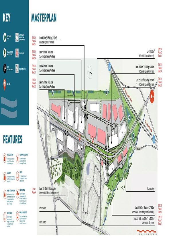
FEASIBILITY STUDY & IMPACT ON SURROUNDING SITES
REMAINDER ERF 38333 RICHMOND BUSINESS PARK, MILNERTON

                                 TABLE OF CONTENTS

Chapter   Description                                   Page

1         INTRODUCTION                                    4

          1.1    Background                               4

          1.2    Proposed Site                            4

          1.3    Traffic Growth Within the Area           5

          1.4    Future Roads                             5

          1.5    Evaluation of Site                       7

2         ESTIMATED SALES OF PROPOSED SITE                8

          2.1    TRAFFIC DEMAND (ADT)                     8

          2.2    AVERAGE FILLS                            8

          2.3    INTERCEPTION RATES (P)                   8

          2.4    FULL TRADING DAYS IN A MONTH (D)         9

          2.5    ESTIMATED FUEL SALES PER MONTH          10

3         OTHER TRAFFIC ENGINEERING CONSIDERATION        11

          3.1    DURING CONSTRUCTION PHASE               11

          3.2    DURING OPERATIONAL PHASE                11

          3.3    DELIVERY VEHICLE CONSIDERATIONS         11

4         COMPETITOR SITES                               12

5         CORRIDORS OF INTEREST / FUTURE DEVELOPMENT     13

6         FEASIBILITY OF PROPOSED SITE                   15

7         TOWN PLANNING OVERVIEW                         16

8         ENVIRONMENTAL SENSITIVITY DESKTOP              17

9         RECOMMENDATIONS                                18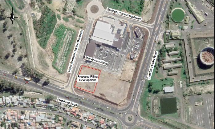
FEASIBILITY STUDY & IMPACT ON SURROUNDING SITES
REMAINDER ERF 38333 RICHMOND BUSINESS PARK, MILNERTON

LIST OF ANNEXURES

ANNEXURE A
  •   LOCALITY MAP

ANNEXURE B
  •   FUTURE ROADS

ANNEXURE C
  •   PROPOSED SITE LAYOUT

ANNEXURE D
  •   PEAK HOUR TRAFFIC DATA

ANNEXURE E
  •   TRAFFIC COUNTS

ANNEXURE F
  •   SITE COMPETITORS

ANNEXURE G
  •   ZONING INFORMATION

ANNEXURE H
  •   SURROUNDING LAND-USES

ANNEXURE I
  •   ENVIRONMENTAL SCREENING REPORT
1 INTRODUCTION
1.1 Background
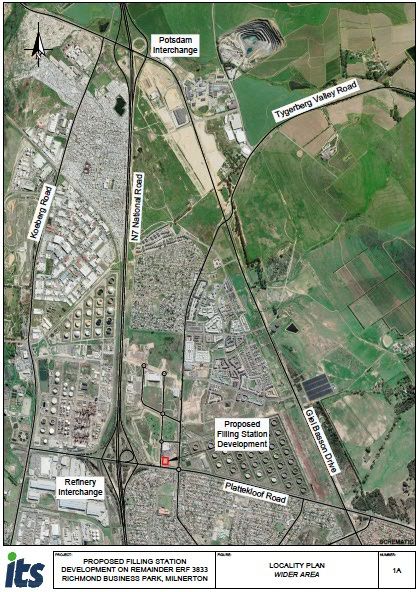
Ngovu Properties was appointed to investigate the proposed location for the development of a
filling station. A study was launched into opening and operating a filling station in the Richmond
Business Park, which is situated alongside the intersection of Plattekloof and Tyger Valley
Roads, Milnerton in the City of Cape Town.
This evaluation is for a modern filling station with a canopy covered forecourt, 5 Pump Islands
and four tanks selling petrol and diesel fuels and a modern 330m² convenience store, all on a
site that has enough space to accommodate such a development seen in Annexure C (all
annexures can be found as attachments to the report). The purpose of the study is to determine
if the proposed site is feasible for opening and operating a modern, benchmark filling station.
The study considers the development viability by assessing the impact on competitor stations
and the projected volume of fuel to be sold from this filiing station.
In addition to the forementioned the report investigates other risks for mitigation i.e. the
environmental sensitivities on the property, verify the approved land use rights, the local
economy or future developments and other competitive filling stations in the area.
1.2 Proposed Site
The location of the site is indicated on the locality map in Annexure A. The site area is within
the emerging Richmond Business Park Area, A filling station with five (5x) pump islands (10x
pump bays) and a 330m² total Gross Leasable Area (GLA) convenience store is proposed., it is
bounded by Upper Southern Precinct Boulevard the proposed property including the imminent
development of the within the Richmond Business Park.
pg. 4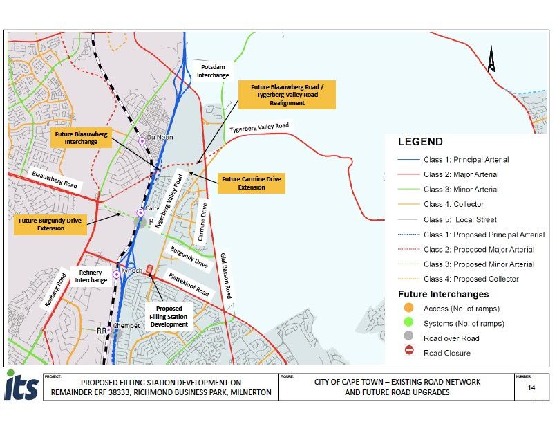
1.3 Traffic Growth Within the Area

Peak hour traffic counts were done on Tuesday, 23 February 2021 during the Covid‐19 Level 1
lockdown period. These 2021 counts were compared with Sept. 2019 traffic counts and found
to be 13% and 2% lower than the 2019 traffic counts, for the weekday AM‐ and PM peak hours
respectively.

Hence, the 2021 counted traffic volumes were escalated with these growth rates, PLUS an
additional two percent growth rate was added per year over the two year period, to determine
the calculated 2021 Existing Traffic volumes.

These 2021 traffic counts were done, to identify changes in traffic patterns and turning
movements at intersections since 2019, due to changes in the road network, such as the
completion of the Giel Basson Drive link (completed mid‐2020). This calculated 2021 peak
hour traffic volumes was used for the Existing Traffic capacity analyses.

Site visits was also done in March 2021, during the peak traffic periods. The following was
observed during these site visits:

¨ Plattekloof Roundabout: The southbound right‐turn movement were relatively busy during
  the AM peak period, although the roundabout operated acceptably.
¨ A number of cyclist were observed along Tygerberg Valley Road / De Grendel Road,
  through the Plattekloof roundabout.

The 2021 Existing Traffic conditions are based on the calculated traffic volumes as well as the
existing intersection geometries and controls. Based on the Existing Traffic capacity analysis
results, the following are concluded:Most study intersections currently operate acceptably.

However, the following intersection experiences constraints and require upgrades:

        Int. 1 Plattekloof Road / N7 Western Terminal: currently operates at unacceptable
        Levels‐Of‐Service LOS E / F, delays greater than 50 seconds and Volume‐to‐Capacity
        (v/c) ratios of 86% / 97% during the AM / PM peak hours respectively. Relatively long
        delays and queues are experienced on the north‐ and eastbound approaches of this
        intersection.

A Traffic Impact Assessment (TIA) in support of the proposed filling station development was
prepared by Innovative Transport Solutions (ITS) dated April 2021. An annual traffic growth
rate of 2% was recommended in this TIA and approved by the relevant metropolitan
municipality.

This recommended annual traffic growth rate will be adopted in this Feasibility Study for the
next 3 years.

1.4 Future Roads

The feasibility of a filling station is influenced to a large extent by the ease of access to the
filling station. The property is conveniently situated within the Richmond Business Park on the

                                                                                       pg. 5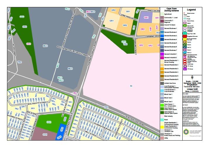
Corner of Plattekloof Road and Upper Southern Precinct Boulevard and easy access onto the
N7 Highway.

Several road links, intersection‐ and interchange upgrades are planned in the vicinity of this
development, as summarised below and shown on Annexure B

    ¨ The extension of Giel Basson Drive – (already) completed mid‐2020.
    ¨ Refinery Interchange (Plattekloof Road / N7 Freeway Terminals) – Reconstruction
      scheduled to commence in September 2021.
    ¨ Extension of Burgundy Drive, between Tygerberg Valley Road and Koeberg Road,
      across the N7 Freeway – construction of the section across Richmond Park to
      commence before end‐2021.
    ¨ Dualing of Tygerberg Valley Road, between Carmine Drive and Burgundy Drive –
      expected to commence in 2022.
    ¨ Extension of Carmine Drive to the future Blaauwberg Road extension‐ Note, approx.
      70% of this road link is already constructed.
    ¨ New Blaauwberg interchange, including a link road between Koeberg Road and the re‐
      aligned Tygerberg Valley Road. – date unknown.

These link upgrades are expected to result in changes to the existing traffic patterns and
distribution. It is likely that once this full road network is in place, that the traffic volumes along
Tygerberg Valley Road could reduce. However, the remaining development potential in this
area might again take up the available spare capacity, resulting in similar traffic volumes (than
evaluated in this report) along the study road sections.

                                                                                             pg. 6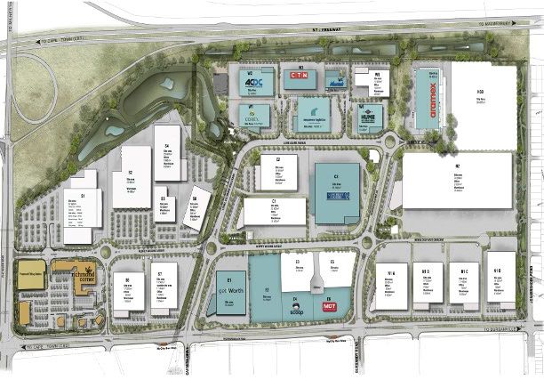
1.5 Evaluation of Site

The study site was investigated on 28 February 2020. A qualitative assessment was made and
the site was ranked according to the following scale:

 VERY POOR                  POOR         AVERAGE            GOOD                VERY GOOD

•       Visibility : The site is strategically located along the intersections of Plattekloof Road
and Upper Southern Precinct Boulevard. With no natural obstructions or developments
potentially impairing the visibility, the site is visible to passing traffic, the visibility can be
described as VERY GOOD;

•        Access : Full access off Mall Entrance Road and Left Out on Upper Southern Precinct
Boulevard is supported by the roads authority but may not be used for anything other than the
filling station. With these two proposed accesses, it can be mentioned that the access
arrangement will thus be considered AVERAGE. There will be a limitation with the proposed
Access which will limit accessibility for cars travelling North and through the Mall Entrance
Road. A layout of the proposed access arrangement is attached in Annexure C.

•       Trading Market : The trading market is described as VERY GOOD. The site is
positioned to serve mainly the transit market along Plattekloof Road, the Richmond Business
Park and New Burgundy Housing Developments. The traffic along this route does consist of
high passenger vehicles, trucks and taxi’s.

•        Traffic Volumes: The traffic data viability analysis indicated that the subject site is
currently exposed to high volumes of traffic which is likely to increase due to the phased
completion of Richmond Business Park retail/office land parcles and furthermore, traffic off the
Tygervalley Road with the proposed housing developments in and around the Burgandy Estate
that are envisioned to develop in future. Exposure to traffic can thus be described as GOOD.

Considering the criteria discussed above, it can be concluded that the study site has GOOD
trading potential.

                                                                                         pg. 7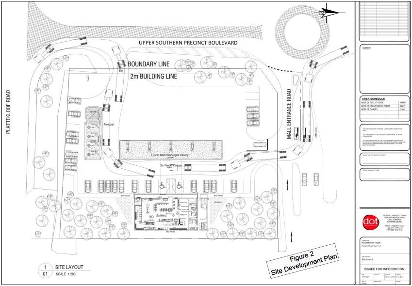
2 ESTIMATED SALES OF PROPOSED SITE

2.1 TRAFFIC DEMAND (ADT)

The viability analysis data was a summary of all vehicles counted at the time.

    •    Weekday AM peak hour (Surveyed peak hour 06:45 to 07:45)
    •    Weekday PM peak hour (Surveyed peak hour 16:30 to 17:30)

The peak hours were determined from the peak period traffic counts. Details of the data are attached
at the back of the report as Annexure D.

2.2 AVERAGE FILLS

The ‘Average Fill’ expected for the subject site was estimated, based on the following:
• Location of the site (eg: middle-income area);
• Type of traffic to be served (local and/or transient); and
• Average fills recorded over a reasonable period at other filling stations in the area.

Based on the average fill rates recorded at a number of filling stations in the study area, as well as
Ngovu Properties's experience with filling stations trading in a similar market, an average fill of
25.8 litres per vehicle for light vehicles was adopted for the subject site.

2.3 INTERCEPTION RATES (P)

The South African Trip Generation Rate (SATGR) manual recommends a 4 percent total capture
rate of traffic volumes on the surrounding road network, and recommends that 16% of this total
captured volume are net‐new trips. The above percentages and recommendations are based on old
data. Hence, a rethink of these percentages is proposed, as agreed by CoCT officials.

The following methodology was used to calculate this filling station development trips:

•   The Filling Station and Convenience Store trips were calculated separately.
•   Filling station = apply a 3% total capture rate (Based on the 2001 Paper “Revision of the
    Guidelines for Access to Filling Stations in the Greater Pretoria Area”). All filling station trips
    to be evaluated as pass‐by / diverted trips.
•   Convenience Store = The total GLA of the C‐Store is 330m2. However, the trip generation is
    based on the retail floor space only (i.e. 200m2 rounded value). The office, storage, ablutions
    facilities, ATM and refuse areas were included as part of the filling station trips, as agreed
    with CoCT officials. The relevant pass‐by (13%) and diverted (29%) percentages were also
    applied.
•   Shared Trips = since the trips are calculated separately for the different land‐uses and since
    some shared trips are expected, a 10.4% shared trip reduction factor is recommended. (Based
    on
                                                                                             pg. 8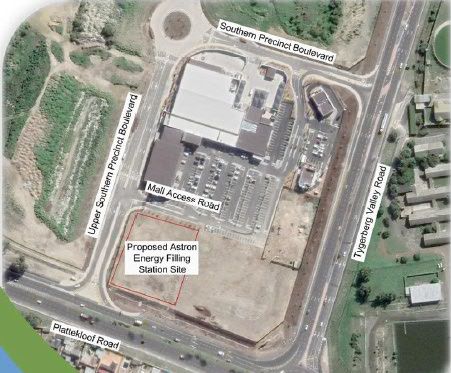
•   the 2001 Paper “Revision of the Guidelines for Access to Filling Stations in the Greater
    Pretoria Area”).
•   Based on the above methodology, this Filling Station and Convenience Store is expected to
    generate the following peak hour (pass‐by / diverted / nett new and total) vehicle trips:

          Trip Type                 Weekday AM Peak Hour            Weekday PM Peak Hour

                                      In        Out       Total       In        Out      Total
    Pass‐By / Diverted Trip           38         38        76         68        68        136

        Nett‐New Trips                 4         3          7         12        12         24

          Total Trips                 42         41        83         80        80        160

From the above table, this development is expected to intercept / generate 83‐ / 160 total trips
during weekday AM / PM peak hours respectively. The majority of these trips will be intercepted
/ captured trips, with only a few nett‐new trips being generated by the convenience store.

This development is expected to generate 24 total nett‐new trips during the weekday PM peak
hour and only 20 nett‐new trips when including the 15% Public Transport reduction, as agreed
with CoCT officials. See Figure 6 for the expected intercepted / generated development trips and
the distribution of these trips through the surrounding road network.

The 2024 Total Traffic volumes were calculated by adding the expected filling station
development trips (including pass‐by, diverted, intercepted and nett new trips) to the 2024
Background Traffic volumes.

The geometry used in this scenario is based on the existing intersection geometries (Annexure E
see, Figure 3), plus the upgrades planned at the Refinery Interchange (Annexure E, See Figure
4C), plus the access / intersection upgrades recommended as part of this filling station
development. (Annexure E, See Figure 7).

Based on the capacity analyses results, all the study intersections are expected to continue to
operate at acceptable levels‐of‐service, during the peak hours analysed. Hence no additional
upgrades are required as part of the filling station development.

However, a single lane roundabout is proposed at the Upper Southern Precinct Blvd. / Mall
Access Road intersection, to ensure acceptable long term operations. This intersection would
operate acceptably as part of the filling station development with the existing geometry and
control, but this upgrade is proposed, to mitigate disruption of traffic flow in the future.

2.4 FULL TRADING DAYS IN A MONTH (D)

The definition of full normal trading days in a month is the number of typical weekday sales in a
month. A typical weekday is a Tuesday, Wednesday or Thursday during a week with no holidays
or public holidays. If there is no variation in the traffic there will be 30,5 (365/12) full normal
trading days in a month.

                                                                                           pg. 9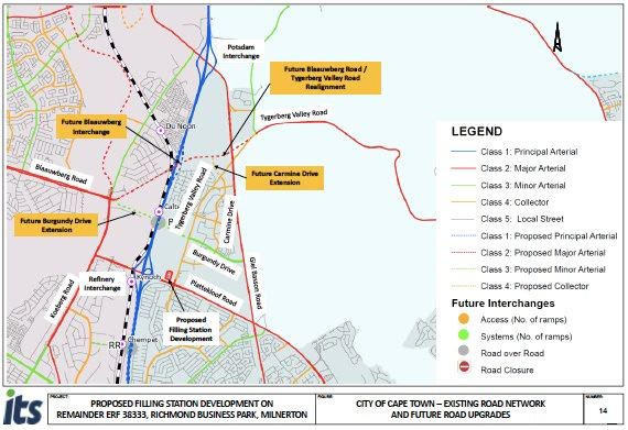
A small variation between weekday and weekend traffic is expected particularly to the industrial
area. Sunday traffic is expected to be much lower, therefore 30 full trading days were assumed for
light motor vehicles.

2.5 ESTIMATED FUEL SALES PER MONTH

The following empiric formula is used by the fuel industry to calculate the expected average litres
of fuel to be sold in a month:

                                                 L = ADT x F x p x d

Where:

             L = is litres sold per month
             ADT = is the average daily traffic
             F = is the average fill per vehicle
             p = is the percentage of pass-by traffic turning into the site (interception rate)
             d = is the number of full trading days in a month

Each one of these factors used in the calculation for fuel sales are discussed in the following
subsections of this Section.

Table below provides a breakdown of the estimated monthly fuel sales:

                 ESTIMATED FUEL SALES PER MONTH (EXISTING TRAFFIC) ALL VEHICLES (INCL. CARS AND MINIBUS TAXIS)

         MONTHLY POTENTIAL FUEL SALES
                                                  PLATTEKLOOF ROAD                         TYGERVALLEY ROAD
         MOVEMENTS                          EAST BOUND       WEST BOUND              NORTH BOUND      SOUTH BOUND

         TRAFFIC FLOW (EST 24HR VEH/DAY)              4 792              1 961                3 128                2 791

         AVERAGE FILL (LITRES/VEH)                      25,8               25,8                25,8                  25,8

         TRADING DAYS (DAYS/MONTH)                       30                 30                   30                   30

         INTERCEPTION RATE (%)                           4%                 1%                   3%                   3%

         MONTH FUEL SALE VOLUME(LPM)                148 362             15 175               72 632               64 817

         SUBTOTAL                                                           300987

                             TOTAL ESTIMATED MONTHLY SALES POTENTIAL (1 YEAR)                                    300 987

Table below estimates the Volume Forecast for the Proposed Filling Station:

                        Year                      Fuel Volume                         Growth %
                        2021                        300987                               2%
                        2022                        307006                               2%
                        2023                        313146                               2%
                        2024                        319409                               2%
                        2025                        325798                               2%
                                                                                                                    pg. 10
3 OTHER TRAFFIC ENGINEERING CONSIDERATION
The impact of the proposed filling station on the existing traffic flow is considered for the following
two phases:
3.1 DURING CONSTRUCTION PHASE
During the construction phase, construction vehicles, abnormal vehicles or freight vehicles could
affect and/or disrupt current traffic flows. During this phase possible traffic congestion or increase
in congestion, temporary obstructions in the roadway and the influence adjacent developments must
be considered.
3.2 DURING OPERATIONAL PHASE
During the operational phase, the existing traffic flow patterns on the roadways adjacent to the
proposed filling station are expected to vary and change over time. Filling stations are
developments that intercept trips from the background traffic as opposed to other developments
that generate additional trips. The interception of traffic could cause minor disruptions if not
considered thoroughly.
The following issues should be considered to minimise the possible negative impacts the proposed
filling station might have on the passing traffic during the operational phase:
• The detailed design of the proposed filling station should adhere to the prescribed specifications
(and subsequent approval) of the applicable road authorities;
• Care should be taken pertaining to the placing of signage in the proximity of access points to
the proposed filling station;
• Issues pertaining to damages and poor condition of the roads in close proximity of the filling
station should be reported to the applicable authority and custodian of the respective roads; and
• Appropriate signage and traffic measures should be implemented at the filling station to ensure
safe and convenient access for passing traffic.
It is concluded that the impact on the existing traffic past the site will not be negatively affected by
the proposed filling station’s operations if all issues mentioned are addressed.
3.3 DELIVERY VEHICLE CONSIDERATIONS
Similar to road safety, the path of the delivery vehicle is also evaluated by the road authority. The
geometric standards adopted in the design manuals allow for a delivery vehicle to enter and exit a
site safely. Typically, the entrance lane width should be at least 5 m to accommodate a Single Unit
+ Trailer Heavy Vehicle. For light vehicles, a minimum width of only 3.5m is required.
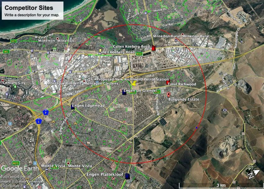
pg. 114 COMPETITOR SITES
There is five competitor stations within the normal 3km radius of impact, the closest is 0.55km
away, see Annexure F. The trading area is located just outside the City of Cape Town within the
growth area of the Tygerberg Municipality and therefore the need for fuel station opportunity.
From a Petroleum Licensing point, we would need a very strong motivation for the Site and
Retail License applications to receive a positive recommendation. Justification could be done
through a detailed Competitor Volume Analysis by doing actual traffic counts at the various fuel
stations and analysing each site.
We estimate that the proposed new site will not impact the below sites significantly as it is
targeted at the New Richmond Park Development and the New Burgandy Housing Developments
that are currently underway. It is likely to intercept the same passing traffic for the Total
Richmond, Engen Plattekloof, as well as Engen De Grendel Motors and has already prompted
objections to the Environmental Application. They are likely to do same on the Petroleum Site
and Retail Licenses.
Table below illustrates competitors impacted by the Proposed Filling Station and the likely
volume to be taken from these sites.
Competitor Name Offering Estimated Estimated Distance
Fuel Fuel from
Volume Volumes Proposed
(Litres / From Site
Month) Competitors
Total Richmond Bonjour Shop, Steers 450 000 45 000 1.70km
Engen De Grendel Quickshop,Bakery 320 000 32 000 0.55km
Motors
Engen Edgemead Quickshop, Bakery 400 000 40 000 3.24km
Caltex Koeberg Freshstop, Seattle 450 000 45 000 2.67km
Shell Koeberg Road Select Shop, Steers 350 000 35 000 2.70km
Engen Plattekloof Quickshop, 380 000 38 000 3.58km
Woolworths, Bakery
The estimated volumes that we would take from the competitor sites is estimated at 10%. With
the anticipated volume taken from the above sites it would not render any of the above sites
uneconomical. The additional projected volume will be derived form the proposed surrounding
Developments of Richmond Business Park and Burgandy Housing Estates.
pg. 125 CORRIDORS OF INTEREST / FUTURE DEVELOPMENT
ATLANTIC HILLS BUSINESS PARK
The development will be a secure 44-Hectare industrial estate with 24-hour security,
security fencing and manned gate houses. Units will range from 600m² to 40,000m² with
sufficient power to meet low and high use purchasers or tenants. The development will be
integrated into the City of Cape Town’s Integrated Transport System providing public
transport access from Milnerton, Parklands, Plattekloof and Durbanville.
pg. 13RICHMOND BUSINESS PARK
Developed with the view of being at Cape Town’s logistical hub, Richmond Business
Park is located in the Durbanville area on the intersection of the N7 and M12. Take your
business to the skies or the seas, with both the harbour and Cape Town International
Airport within a 22km radius, or spread your business from the confluence of all major
distribution roads.
Richmond Park is serviced by two major arterial routes, the N7 highway and Plattekloof
Road (M14), ensuring convenient access to the N1 highway, Cape Town Port, the Cape
Town CBD and the Airport.
Extensive road upgrades, include, inter alia, the dualling of Plattekloof Road from the
N7 Eastern Terminal to the N1 and the dualling of Tygerberg Valley Road from
Plattekloof Road to the entrance of the Park.
Easy access to public transport: Taxi, train and MyCiti bus. Chempet train station is
situated 5km from the Park.
Richmond Corner is anchored by Pick ‘n Pay, Woolworths Food, Clicks and also
features Vida e Café and two drive-trhough restaurants namely Burger King and KFC,
amongst the 20 shops.
Proposed
New Filling
Station
pg. 146 FEASIBILITY OF PROPOSED SITE
The table below provides a summary of the indicative typical costs associated with the rebuild
of a new filling station development for a minimum monthly fuel sale threshold.
CONVENTIONAL FILLING STATION DEVELOPMENT COSTS
ELEMENTS COSTING ZAR (2021)
BULK SERVICES CONTRIBUTIONS / CONNECTION FEES
EARTHWORKS & EXCAVATION 432 000,00
Site Clearance & Earthworks 300 000,00
Foundations 132 000,00
BUILDING WORKS: 2 435 200,00
Building & Roof Covering 1 740 000,00
Carpentry (doors, locks, ATM drs, drop safe, office safety dr) 199 200,00
Ceilings & Partitioning & Glazing 298 000,00
Finishes (tiling. painting) 198 000,00
MECHANICAL & FIRE INSTALLATION 495 000,00
Mechanical 375 000,00
Fire protection 120 000,00
INTERNAL SERVICES 1 400 000,00
Electrical Installation incl Canopy Lighting 750 000,00
Plumbing & Drainage 650 000,00
ROADWORKS
Civil & Road Works (layerworks, paving, road marking) 1 075 991,93 1 075 991,93
LANDSCAPING
Land Improvements - fencing, landscaping 343 750,00 343 750,00
FUEL SYSTEM & CANOPY
Canopy, Pump & Tanks Complete: 6 122 108,52
Tanks 791 364,00
Pumps 498 750,00
Fibrelight Material 299 015,52
Pipe Material 498 855,00
Software- ATG, ISIS, Ligthening Protection 1 243 433,00
Pump & Tank Installation 1 290 691,00
Canopy & Lights 1 500 000,00
SHOPFITTING 687 500,00
Shop Equipment & Fittings: 687 500,00
SIGNAGE & IMAGE 375 000,00
Signage (Incl Retail, VM, RM etc): 375 000,00
COMPUTER / CCTV 412 000,00
Computer / cctv 412 000,00
GENSET
Generator 275 000,00 275 000,00
OTHER
Contingency (5%): 702 677,52
Professional Team Fees (7%): 983 748,53
TOTAL COSTING 15 739 976,50
pg. 157 TOWN PLANNING OVERVIEW
Property Description: Erf 8 Atlantic Hills, CITY OF CAPE TOWN
Current Land Use Right (Zoning): The property in question is currently zoned “Mixed Use 3”
according to the City of Cape Town Map Viewer (GIS), refer to Annexure G. With reference
to the City of Cape Town Zoning Scheme Regulation 2012.
Primary uses permitted within this zoning includes: Business premises, industry, dwelling
house, second dwelling, boarding house, flats, place of instruction, place of worship,
institution, hospital, place of assembly, place of entertainment, hotel, conference facility,
authority use, utility service, rooftop base telecommunication station, transport use, multiple
parking garage, private road and open space. Attached is a screenshot of the City of Cape
Town Zoning Scheme Regulation, 2012 as Annexure G
Secondary rights which can be obtained through a consent applications, which is permitted
only if Council grants it approval for such consent use includes: Adult shop, adult
entertainment business, adult services, informal trading, expo centre, scrap yard, freestanding
base telecommunication station, wind turbine infrastructure, helicopter landing pad, service
station and motor repair garage. Attached is a screenshot of the City of Cape Town Zoning
Scheme Regulation 2012, as Annexure G
Surrounding Use: Surrounding land uses include Industries, Vacant land, Main road and
Single dwelling (A map is attached as Annexure H showing the surrounding land uses). Any
other land use right not mentioned above, can be obtained through the rezoning application or
township application, provided it is aligned with the Spatial Development Framework (SDF)
of the area.
Land Use Rights Application: Based on the desktop analysis of the site and looking at the City
of Cape Town Zoning Scheme, attached as Annexure G, a Subdivision and Consent
Application will need to be submitted to obtain the rights for the provision of a petrol filling
station.
• Subdivision- Need to subdivide the portion needed for the petrol filling station,
because the subject property is 6.1318H and that’s too big for a PFS
• Consent- A PFS according to be Zoning Scheme falls under secondary rights,
which are obtained through the submission of a Consent Application
pg. 168 ENVIRONMENTAL SENSITIVITY DESKTOP
SLR Consulting (South Africa) (Pty) Ltd (SLR) was appointed by RPDC as the independent
EAP to undertake a Basic Assessment (BA) process for the Filling Station Application in terms
of the Environmental Impact Assessment (EIA) Regulations 2014 (as amended) promulgated in
terms of the National Environmental Management Act (Act No. 107 of 1998;
NEMA). The compilation of this EMPr forms part of the requirements of the EIA Regulations
2014 (as amended). This EMPr will be submitted to DEA&DP for approval as part of the BA
process and the final version, if necessary, will be updated to comply with any conditions of
authorisation.
The screening tool Annexure I by the Department of Environmental Affairs picked up a very
high sensitivity for Terrestrial Biodiversity, Aquatic Biodiversity as the ecosystem around the
area of the proposed development is noted to be critically endangered. The civil aviation theme
was high as the site is with a 15km radius of civil aviation aerodromes and radars.
Environmental Authorisation (EA) for the overall Richmond Park development was obtained
on 21 September 2012 (EIA Ref: E12/2/4/2-A6/399-1009/10) (which was subsequently
amended on 1 August 2013 (EIA Ref: 16/3/1/5/A5/106/1019/13)) by means of a Scoping and
Environmental Impact Assessment (EIA) process.
The EA provided for the development of a mixed-use of retail, industrial and general
components on the land referred to as Richmond Park.
Construction within Richmond Park has already commenced and large portions of the approved
development area (including Erf 38333) have already been cleared to establish building
platforms.
As the above-mentioned Scoping and EIA process considered the development and use of the
overall site for Richmond Park (which includes Erf 38333) and site clearing on the proposed
project site has already taken place, no additional specialist studies with respect to vegetation,
freshwater and heritage issues will be undertaken as part of this Basic Assessment (BA) process.
As the current application relates to the establishment of a fuel station, only additional potential
impacts associated with the proposed project will be assessed.
No natural surface water resources are located on or in close proximity to, the site. In terms of
the City of Cape Town (CCT) 2018 Biodiversity Network, Erf 38333 is demarcated as an
Unselected Irreversibly Modified Site. No sensitive environments have been identified on site,
or in close proximity (see Appendix D).
The site is underlain by undifferentiated coastal deposits (unconsolidated to semi-consolidated
sediments including, sand, calcrete, calcarenite, aeolianite, marine gravel clay, silcrete and
limestone) of the Sandveld Group. Groundwater depth is estimated at approximately 7 m below
ground level. The aquifer below the site is classified as a major aquifer of most vulnerability
and high susceptibility. Groundwater is inferred to flow in a westerly / north-westerly direction
towards the Bothasig, with potential influence from on-site topography and / or road
infrastructure in the downstream direction. The site is characterised by medium to highly
permeable subsoils.
pg. 179 RECOMMENDATIONS
This development presents the opportunity for a 24 hour Fuel Station, Convenience Store and a Fast
Food Restuarant. The proposed filling station is Feasible and is Recommended for development. With
the estimated fuel volume potential of 300 987 litres / month the site could successfully co-exist
amongst its competitor sites.
The estimated Convenience Turnover R450 000 / month excluding fast food sales, provided the right
product range is stocked for this unique market.
The site is part of the greater Richmond Business Park Development and as per the development
information received, it should be fully developed within the next 3 years.
Current Land Use Right (Zoning): The property in question is currently zoned “Mixed Use 3”
according to the City of Cape Town Map Viewer (GIS), refer to Annexure G. With reference to the
City of Cape Town Zoning Scheme Regulation 2012. A Special Consent Use application is required to
make provision for a Petrol Filling Station on the said property.
The zoning certificate obtained for this site still reflects the greater township approval rights.
The desktop environmental screening by the Department of Environmental Affairs picked up a high
sensitivity for Archaeological And Cultural Heritage Theme, Civil Aviation Theme, Terrestrial
Biodiversity Theme Sensitivity. A Basic Assesment Application for the proposed filling station is
currently under way and has addressed the above sensitivities.
From a Petroleum Licensing aspect, the site would be supported as this is part of the Cape Town
growth areas and we do not believ this development will have a significant impact on the existing fuel
stations in the area as the focus is on new markets therefore new volumes being created. The
Petroleum Site and Retail Licenses is required prior to this Petrol Filling Station development can
commence.
The estimated timeline for finalisation of the Environmental Authorisation, Town Planning Consent
Use and Petroleum Licenses applications is 18 months.
pg. 18Annexure A – Locality Map
pg. 19Annexure B – Future Roads
pg. 20Annexure C – Proposed Site Layout
pg. 21Annexure D – AM and PM Peak Hour Traffic Count
pg. 22Annexure E – Lane Configuration and Road Upgrades
pg. 23Annexure F – Competitor Fuel Stations
pg. 24Annexure G – The City Of Cape Town Zoning Scheme Regulation 2012
pg. 25Annexure H – Surrounding Land Uses
pg. 26Annexure I – Environmental Screening Tool
!
"#$%%&'&(!$%)*$+!,*$!-&!%&.'$*&/%&+-0!-1+2*$'3-+'*&!*$!!
,*$!-!)-$+!+4*!-/%&5/%&+!*,!-&!%&.'$*&/%&+-0!-1+2*$'"-+'*&!!
-"!$%61'$%5!78!+2%!9:;32&!&I&90=,&)2!J0,=3)K!L/2KM!N26!!
J0,=49&(.!!!%4OP35!;37&(!!
J0,=49&(!You can also read