Waikato GAA Revision 2021 - CAA
←
→
Page content transcription
If your browser does not render page correctly, please read the page content below
Airways – GNZ Waikato airspace collaboration 2018

Waikato GAA Revision 2021

Petition by Gliding New Zealand to amend GAA in the Waikato Region for compatibility with PBN
procedures.

Revision 8
26 March 2021
This revision replaces the original petition presented in January 2019.

26 March 2021                                      Revision 8                                   Page 1 of 27
Airways – GNZ Waikato airspace collaboration 2018

Airways / Gliding NZ airspace collaboration 2018

Introduction
This submission is the most co-operative airspace exercise that representatives from Gliding NZ or its
predecessor have ever been a part of. It has been devised at a level of consultation between the parties never
before possible without the services of Mahino Research and its principal -Tim Hughes.
Over the winter and spring of 2018, GNZ and Airways co-developed this proposal in a series of workshops,
informed by ongoing consultation with affected parties to optimise airspace and air traffic management for as
many users as possible.
Gliding NZ believes that the expanded consultation process could offer an outcome that its own resources
could never produce and commends similar co-operative exercises when other parts of the country undergo
design change for both airspace and instrument flight procedures in the PBN future.
Gliding NZ is especially grateful for the time and effort by Airways NZ staff, notably Brian Walls and his team in
BAY sector, and subsequently Johl Steel-brown and Ian Reilly of policy and standards, in reaching this point of
mutual understanding of each other’s needs in the use of airspace resources in the Waikato Region.
Many of the General Aviation and Restricted Areas that are destined for cancellation in this review, are the
product of a different era. Gliders and other GA aircraft now have a level of GPS navigation and airspace
display, and therefore the ability to accurately navigate with respect to airspace boundaries, that was
unavailable during prior periods. Simultaneously, PBN procedures create predictable and precise IFR traffic
flight paths. This consultation has sought to take advantage of these developments by structuring the airspace
to enable both PBN/IFR and GA activity with optimal freedom to operate.
The changes proposed in this submission increase safety for gliding. Cross country gliding operations in the
Waikato region have always been tailored to uncontrolled airspace that offer flying safety at altitudes where
options are available to navigate to landable areas. The proposed changes enable greater clearance from
terrain for gliders, improving their ability to reach landable areas.
The proposed changes also increase ATC productivity, and IFR flight efficiency.
Where practicable, glider pilots do not favour entering controlled airspace, as it tends to decrease glider pilot
options while increasing ATS workloads. In the limit case, gliding operations can be significantly constrained by
ATS capacity. The proposed changes maximise the ability for gliders to operate by minimising or removing the
workload imposed on ATS resources.
Whereas the existing GAA definitions conflict with PBN procedures at Hamilton, Tauranga, Rotorua, and
Taupo, the proposed GAA have been designed in collaboration with Airways to be clear of frequently used PBN
procedures, and where that has been impracticable, more efficient flight paths requiring less controller
intervention have been devised. The result improves controller productivity, and flight efficiency for IFR traffic
at all affected locations.
Cross country gliding is a seasonal activity in the Waikato that impacts regular public transport and IFR flight
training in the minor half of the year, specifically afternoon hours from October through March, typically three
or fewer days per week, and only when operating days align with suitable weather. Requests for activation
other than these short periods are rare. As a result, where there is an unavoidable minor effect on RPT flights,
such events will be infrequent.
This proposal is designed to have a long life at a time of generational change in New Zealand's airspace
technology. This airspace solution is offered on a win/win basis for your consideration.

26 March 2021                                       Revision 8                                      Page 2 of 27
Airways – GNZ Waikato airspace collaboration 2018

Background
Airways BAY sector has approached Gliding NZ to collaborate on resolving operational issues with Waikato
airspace. This petition for change is the result of that collaboration and consultation with other users of the
airspace.
The primary goals of these changes are to:
    •    Separate gliding operations from IFR flights, particularly regular public transport (RPT) by harmonising
         airspace boundaries with PBN procedures and common traffic flows
    •    Permanently chart well designed airspace to minimise the need for temporary airspace defined
         annually and published separately in the AIP SUP
The benefits of this approach include:
    •    Improving IFR flight efficiency, airspace capacity, and reducing controller and pilot workload by
         maximising the use of standard procedures.
    •    Increase airspace capacity for IFR flights by removing VFR workload from controllers, and for the
         (higher intensity) VFR flights by increasing the volume of airspace available to VFR flights in areas little
         (or not at all) used by IFR flights.
    •    Safety (1): Improve situation awareness for all airspace users as a result of permanently charting most
         airspace, which is expected to include electronic delivery to pilot navigation equipment.
    •    Safety (2): Improve GA and glider flight safety by enabling greater clearance from terrain and
         therefore improved access to suitable landing areas.
    •    Safety (3): Simplified airspace, including simplifying the separation task of ATS.
    •    Administrative efficiency: Minimised temporary airspace dramatically reduces the workload for glider
         and hang glider/paraglider contests, for CAA, Airways, and the sporting organisations.
In general, these goals are achieved by
     • Separating GAA from frequently used PBN procedures. This enables IFR traffic to fly on procedures
        without ATS radar vectoring, whilst enabling the GAA areas to be opened and used without significant
        impact on flight efficiency. In essence, this petition completes the airspace adjustments demanded by
        the PBN implementation project.
     • Aligning GAA boundaries with adjacent controlled airspace boundaries. This simplifies the airspace
         design and reduces chart complexity, which in turn enables permanent publication.
     • Aligning the temporary restricted areas, which enable cloud flying during glider contests, with the
         GAA areas to minimise, and in most cases eliminate, the impact of glider competitions on IFR traffic
         and ATS workload.
Neither the GAA nor the restricted areas impose any constraint on VFR traffic.

Consultation
Every effort has been made to consult with the main users of the affected airspace. The parties contacted and
their general responses are listed here to simplify the document. Where specific GAA affect an airspace user,
their comments are included in the section discussing that particular change.
The design as a whole has been co-created with Airways New Zealand in a series of workshops during 2018,
and refreshed in discussions during March 2021. This document represents the consensus reached and is
supported by Airways.
Airways has consulted in the third quarter 2018 with controllers, formally with Mt Cook Airlines representing
the Air New Zealand Link group of operators, and informally with L3, Philips Rescue, Ardmore Flying School,
Auckland Aero Club, Taupo Airport Company, and the Waikato Aero Club. All organisations were comfortable
with the proposal at the time. Details in specific areas are mentioned in the text through the document.
GNZ also consulted with
    •    Matamata aerodrome users group (10 September 2018), which includes L3, Parachuting, Model
         aircraft operators, and aeroclubs from the Bay of Plenty and Waikato. With some exceptions by L3,
         the group supports the proposal.

26 March 2021                                        Revision 8                                        Page 3 of 27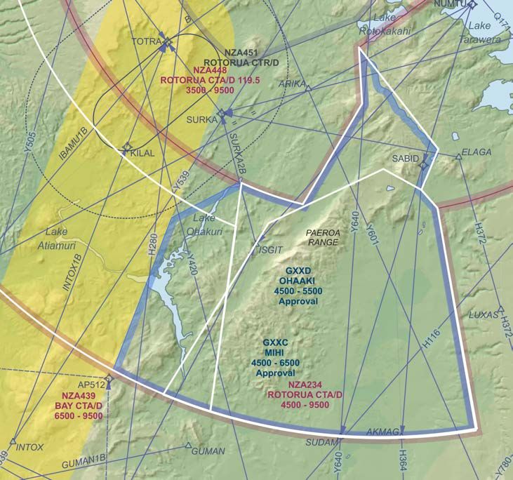
Airways – GNZ Waikato airspace collaboration 2018

    •    L3 on 26 October 2018. L3 ceased operations in February 2021, however it is reasonable to presume
         that high intensity IFR training may resume in future, and their comments are included in the relevant
         sections below.
    •    New Zealand Hang gliding and Paragliding Association in September 2018. NZHGPA are very
         supportive of this petition.
    •    Origin Air and Waikato Aviation in March 2021. Origin have no issues with the proposal. Waikato
         Aviation also have no problems with what is proposed and are happy to support it.
    •    Air New Zealand again in March 2021 regarding the GOSTI2A approach to Taupo. The proposed
         airspace is expected to be acceptable to Air NZ.

Structure of this document
This document sets out the collected change requests in six distinct areas:
     1. Northern end of Hamilton CTA/D
     2. Tarawera
     3. East of Hamilton
     4. West of Taupo
     5. Firth of Thames
     6. Temporary restricted areas between Taupo and Coromandel
Detailed descriptions of the airspaces, in the form used for the national airspace register are in Appendix A.
The following Waikato Permanent GAAs are preserved in this submission:
         G254 Matamata, G272 Huntly, G451 Taupo,
The following Waikato Temporary GAAs are unchanged:
         G295 Pirongia, G294 West Hamilton being activated by AIP Supplement during Gliding Competitions.
The following Waikato Permanent GAAs are proposed to be deleted as a result of redefinition:
         G255 Karapiro, G459 Paeroa Range
The following Waikato Temporary GAAs would become disused as a result of redefinition:
         G482 Reporoa, G483 Tarawera, G481 Tokoroa
The following GAAs are proposed to become permanent charted GAA. Numbers are to be assigned by CAA. For
convenience throughout this document, GAA are identified in a series nominally GXXA, GXXB,…
          GXXA Tirau, GXXB Atiamuri, GXXC Mihi, GXXD Ohaaki, GXXE Rotomahana, GXXF Mangakino,
          GXXH Pureora, GXXM Waerenga, GXXN Miranda
The following temporary restricted areas and GAAs are intended for use only during gliding contests.
         RXXZ Barryville, RXXY Lichfield, RXXX Thames, GXXG Ohakuri

Attribution

“Contains data sourced from the LINZ Data Service licensed for reuse under CC BY 4.0”
Basemap presentation (c) Mahino Consulting Ltd

26 March 2021                                       Revision 8                                      Page 4 of 27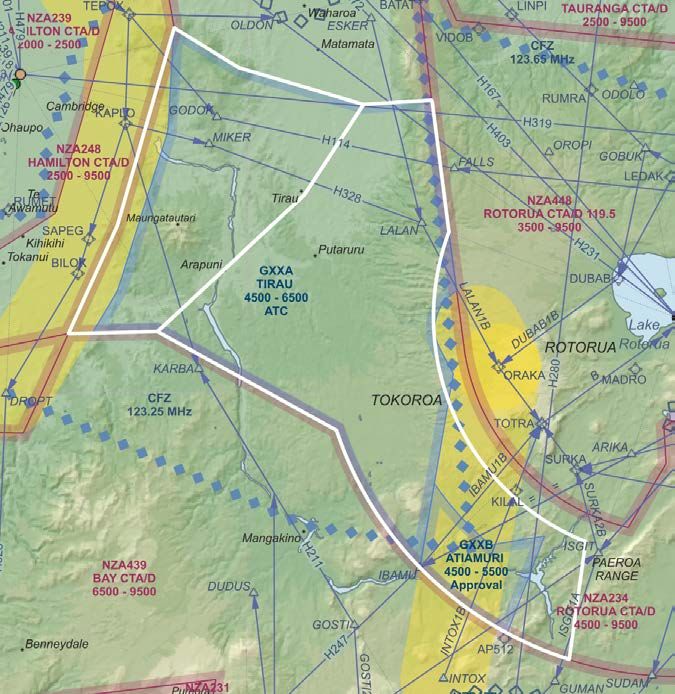
Airways – GNZ Waikato airspace collaboration 2018
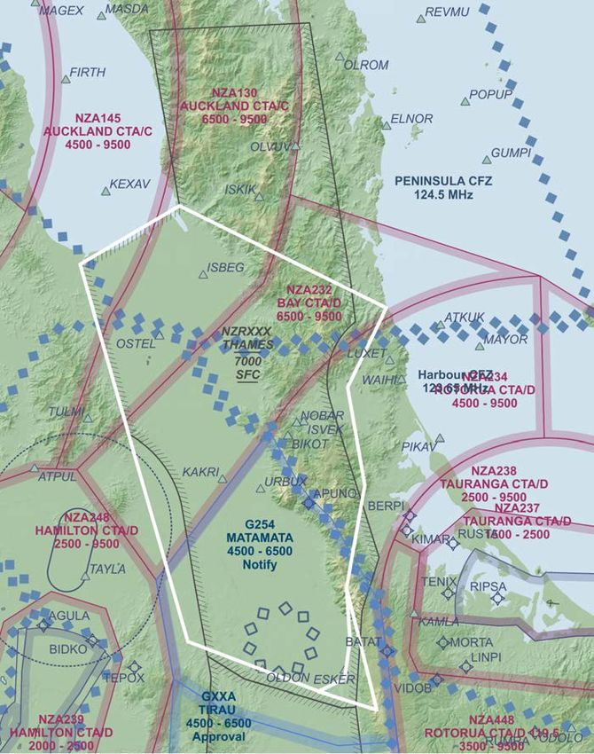
1: Northern corner of NZA248 Hamilton CTA/D (LL 2500)
Requested change
This petition requests a change the northernmost corner of NZA248 Hamilton CTA/D.
Reason for change:
The northernmost corner of NZA248 is close to terrain, constraining GA operations adjacent to controlled
airspace. Flights transiting east-west south of high ground must obtain a clearance from Hamilton Tower to
cross little more than 1nm of airspace. At the same time, this corner is unused by controlled traffic and
contains no IFR routes. This change will enable GA flights to transit through uncontrolled airspace with
improved terrain clearance and without consuming air traffic control resources.
Description of proposed change
s
rie
nda
u
Bo
ing
xist
E
Proposed change to controlled airspace. White lines show the existing boundary to be moved, coloured
map elements are the proposed results.
It is proposed to terminate the northern edge of NZA248 Hamilton CTA at the latitude of the current boundary
inflection point at Te Hoe (immediately northeast of ATPUL).
The existing boundary between NZA145 Auckland CTA/C (LL 4500) and NZA130 (LL 6500) would be unchanged,
and the boundary line extended to meet the new NZA248 boundary.
The southwestern end of the boundary between NZA130 Auckland CTA/C (LL9500) and NZA232 BAY CTA/D (LL
6500) would be moved southeast approximately 1.8 nm to the new corner point of the Hamilton CTA/C,
simplifying the airspace and moving the boundary between class C and class D airspace slightly. The same
change is made to the overlying upper control areas NZA131 Auckland CTA/C and NZA434 Bay CTA/D.
The alignment of the north eastern edge of NZA248 remains unchanged and the boundary is shortened to the
new corner point.
NZG253 MARAMARUA would be modified to follow the boundary of NZA145 in the area, and become
NZGXXM WAERENGA, continuing to be activated “by notification” as for the existing NZG253.
26 March 2021 Revision 8 Page 5 of 27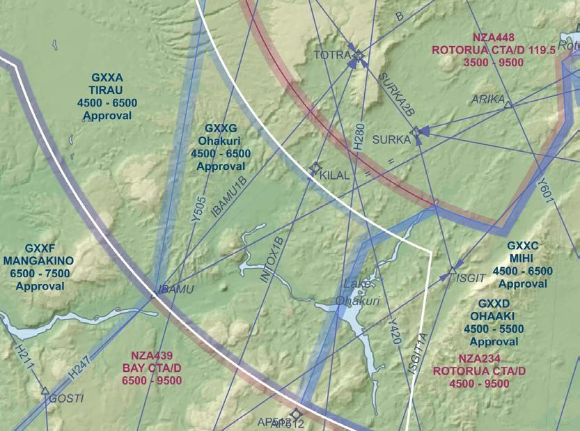
Airways – GNZ Waikato airspace collaboration 2018

Summary of Consultation
Airways and Gliding NZ discussed this change on 2 August 2018, and again in March 2021.
Airways has no objections to moving the boundary in the area north east of ATPUL, as there are no IFR routes
and no controlled traffic using that airspace.
Airways prefer all new GAA to be activated “by approval”, however given the very minor nature of the change
to G253 MARAMARUA, Airways accept continuing the activation of the modified area “by notification”. GNZ
considers it essential to retain the “by notification” status, as the reasons for doing so still exist. The area
continues to be important for glider and GA traffic between Ardmore / Drury and all areas to the south. To
address existing concerns of both parties, GNZ and Airways intend to collaborate on refining the GAA
activation and deactivation procedures.
GNZ supports this change as it increases safety and efficiency by enabling gliders en-route between Drury and
the Waikato/Taupo to use the lift on the adjacent terrain without unnecessarily requiring the time of air traffic
controllers.
GNZ discussed this proposal with L3 on 26 October 2018. L3 have no concerns.

Impact of proposed change
The proposed change has no impact on the levels required to remain in controlled airspace for any IFR routes
or IFR waypoints, and affects no traffic controlled by Airways in the Hamilton CTA/D NZA248.

Affected airspace

 ID             Name          Type    Class    Upper Limit         Lower Limit
 NZA248         Hamilton      CTA     C        9500      FT        2500    FT
 NZA145         Auckland      CTA     C        9500      FT        4500    FT
 NZA131         Auckland      CTA     C        600       FL        9500    FT
 NZG253         Maramarua     GAA              5500      FT        4500    FT
 NZA130         Auckland      CTA     C        9500      FT        6500    FT
 NZA232         Bay           CTA     D        9500      FT        6500    FT
 NZA434         Bay           CTA     D        600       FL        9500    FT

Points
Latitude/Longitude in WGS84 degrees minutes seconds.decimal_seconds.

 Location    Description                                                  Latitude          Longitude
 Te Hoe      Existing corner of NZA248                                    37° 30’ 47.00 S   175° 19’ 15.00 E
             New corner of NZA130, NZA145, and NZG253                     37° 30’ 47.00 S   175° 21’ 15.02 E
             New corner of NZA130, NZA131, NZA232, NZA434 and             37° 30’ 47.00 S   175° 23’ 21.77 E
             NZA248

26 March 2021                                        Revision 8                                    Page 6 of 27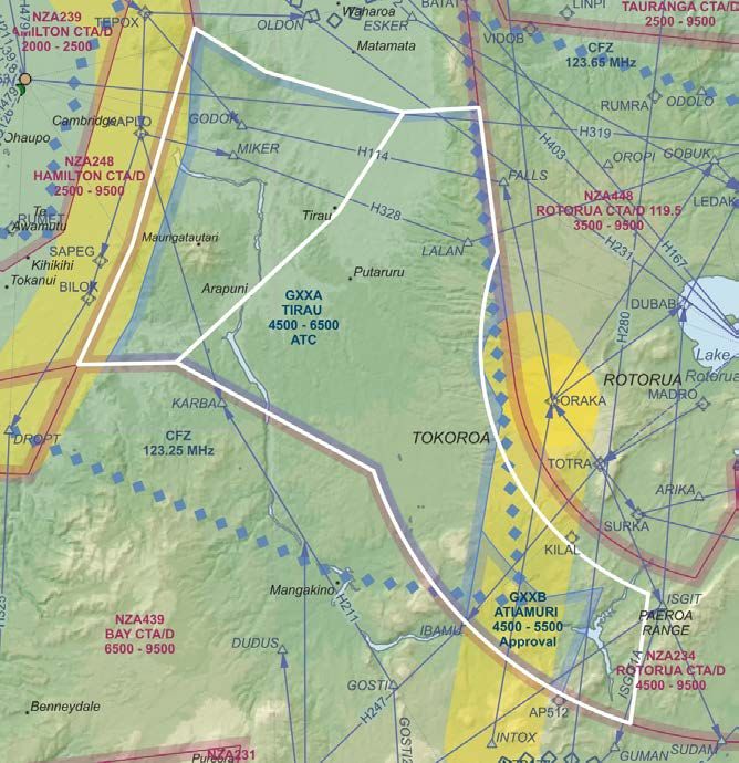
Airways – GNZ Waikato airspace collaboration 2018
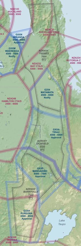
2: Tarawera region GAA areas
Proposed change
This petition requests changes to existing GA areas in the Tarawera region to be harmonised, aligned with
adjacent airspace boundaries, and kept clear of frequently used PBN routes to Rotorua.
Reason for change
Historically separate development of GA areas for hang gliding/paragliding and gliding (sailplanes) around the
Paeroa Range has resulted in overlapping areas with boundaries not aligned with each other or adjacent
airspace. This change seeks to simplify the design of the airspace by aligning the GAA with adjacent airspace
boundaries. These areas enable better use of areas of lift at the northern end of the Paeroa Range. Permanent
charting will simplify the administration of hang gliding / paragliding and glider contests.
Description of proposed change
Changes are requested to existing areas above the Paeroa Range, and the Tarawera thermal region.
Ex
ist
ing
G4
81 G 459
xi sting
E
482
Existing G
Proposed GAA on the Paeroa Range. White lines show the existing G459 Paeroa Range and G482
Reporoa, and G481 Tokoroa to be removed, blue outlined map elements are the proposed replacements.
Yellow band is 3nm lateral separation from INTOX-TOTRA track. IFR SID/STAR procedures, 3nm
boundary around TOTRA hold, and terrain are shown to aid explanation.
It is proposed to replace NZG482 REPOROA, NZG459 PAEROA, and part of G481 TOKOROA with two new areas:
GXXC MIHI (in place of G482 REPOROA) and GXXD OHAAKI (in place of G459 PAEROA). The new areas would
have common lateral boundaries, coincident with NZA234 Rotorua CTA/D and with the boundary of NZB472
Tarawera MBZ. The western boundary of these GAA is located adequately clear of the TOTRA hold, and the
INTOX-KILAL IFR track. This separates these areas from regular public transport arriving to Rotorua runway 36
from the south, and from missed approach traffic on Rotorua runway 18. The vertical limits of each area
remain unchanged: NZGXXD Ohaaki, predominantly used by paragliders, with an upper limit of 5500 amsl,
NZGXXC Mihi upper limit 6500 amsl.
26 March 2021 Revision 8 Page 7 of 27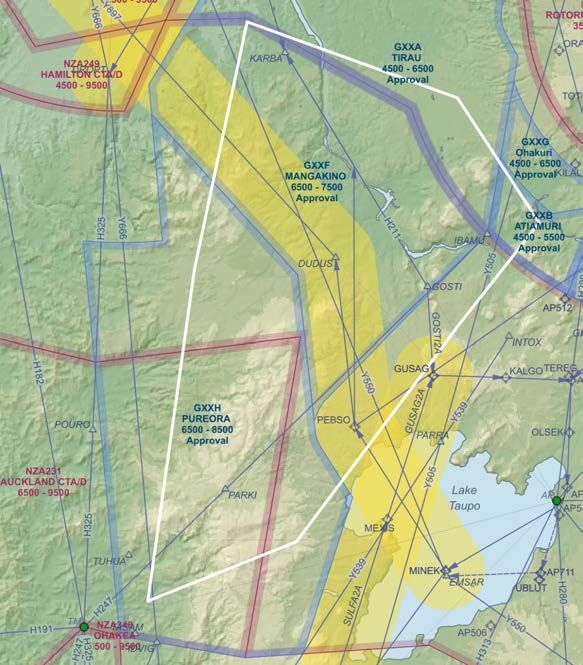
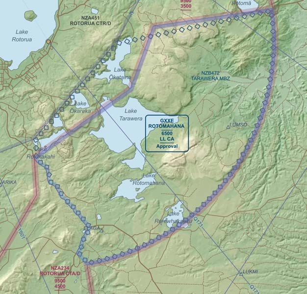
Airways – GNZ Waikato airspace collaboration 2018

   Proposed GAA over Tarawera. Blue outline shows proposed GAA. Diamond outline shows MBZ
   boundary.
It is proposed to permanently chart what was previously temporary NZG483 Tarawera, as a new NZGXXE
Rotomahana.

Summary of consultation
Airways supports these changes as the GA areas, when active, will be below or laterally clear of predominantly
used IFR procedures. GXXE Rotomahana was redrawn as a result of consultation to allow enough room to hold
IFR training traffic south east of Rotorua when necessary.
All three areas are to be activated “by approval”. For safety and administrative efficiency, it is preferable to
have these areas permanently charted rather than being temporary airspace activated by notam.
Gliding NZ and the NZ Hang gliding and Paragliding Association fully support these changes for the reasons
above, provided that approval will be given no less frequently than at present. Airways have confirmed that
they do not expect any additional restrictions to apply.
L3 have no concerns.

Impact of proposed change
The proposed change has no significant adverse impact on IFR traffic controlled by Airways in the Rotorua
CTA/D.

Affected airspace
NZG483 Tarawera, NZG482 Reporoa, and NZG459 Paeroa deleted.
NZGXXC Mihi, NZGXXD Ohaaki, NZGXXE Rotomahana created.

Airspace Description
Description of the new airspaces in the format used by the national airspace register is in appendix A.

26 March 2021                                        Revision 8                                       Page 8 of 27
Airways – GNZ Waikato airspace collaboration 2018

3: Hamilton east GA areas
Proposed change
This petition requests two new GAA east of Hamilton to modify and replace NZG255 and NZG481.

Reasons for change
The proposed GAA is a modifies the existing GAA to be clear of the Hamilton PBN SIDs and Rotorua approaches
used by regular public transport. Currently, NZG255 Karapiro conflicts with PBN SIDs east of Hamilton and
NZG481 Tokoroa conflicts with IFR approaches to Rotorua. Without these changes, the PBN procedures cannot
be used as designed when the GAAs are active, creating unnecessary pilot and controller workload and making
the efficiency and safety benefits of the PBN procedures unavailable. The changes enable straightforward use
of PBN procedures independently of the GA area activation.
There is an additional safety benefit for glider and GA flights. The proposed GAA gives access to the airspace
above Tokoroa and Kinleith that is close above rising terrain, yet devoid of IFR procedures or traffic. This
improves glider safety by enabling greater glide range to safe landing areas, and enables glider traffic to transit
between areas of lift on the Kaimai range, Maungatautari and the hills south of Kinleith without imposing ATS
workload. The area is frequently used by gliders from Auckland, Matamata, Tauranga, and Taupo.

Description of proposed change
It is proposed to replace NZG255 Karapiro and temporary G481 Tokoroa with two alternative permanent
areas: NZGXXA Tirau, and NZGXXB Atiamuri
                                                5
                                              25
                                             gG
                                           in
                                        ist
                                      Ex

                                           Exi
                                                 stin
                                                     g   G4
                                                           81

   White lines show the existing boundary to be moved, blue outlined map elements are the proposed
   results. 3nm clearance from PBN procedures shown yellow. IFR SID/STAR shown for Rotorua runway 18

26 March 2021                                             Revision 8                                  Page 9 of 27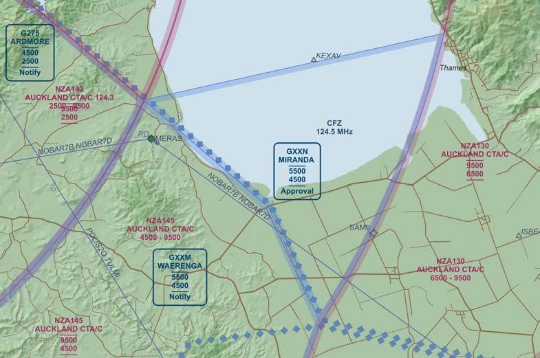
Airways – GNZ Waikato airspace collaboration 2018

                                          5
                                        25
                                        gG
                                      in
                                   ist
                                 Ex

                                         Exi
                                               stin
                                                   g   G4
                                                         81

   White lines show the existing boundary to be moved, blue outlined map elements are the proposed
   results. 3nm clearance from PBN procedures shown yellow. IFR SID/STAR shown for Rotorua runway 36
NZGXXA Tirau is created by merging NZG255 and NZG481, and shrinking the resulting GAA to be clear of PBN
SIDS east of Hamilton and PBN procedures for arrivals to Rotorua. At Hamilton the proposed area remains 3nm
clear of the SID tracks through TEPOX-KAPLO-BILOK-DROPT. At Rotorua the GAA is 3nm clear of a line INTOX-
ORAKA (used for regular public transport flights from Wellington to Rotorua runway 18). It is also clear of an
acceptable descent profile on the LALAN-ORAKA track (used by regular public transport flights from Auckland
to Rotorua runway 36), by remaining 3nm clear of a point on track 3nm from ORAKA. The remaining
boundaries of the new GAA align with airspace boundaries to the south, and the edge of NZG254 to the north.
The remainder of what was NZG481 is replaced by the new permanent NZGXXB Atiamuri. This segment has a
reduced upper limit to be below the approaches to Rotorua from the south, both INTOX-ORAKA and INTOX-
TOTRA. The lateral boundary is also clear of the TOTRA hold. This means that this area is clear of the most
frequently used IFR procedures under most conditions.
Both NZGXXA and NZGXXB are proposed to be activated by ATC approval.

Summary of consultation
Airways supports these changes as they make frequently used PBN procedures at Hamilton continuously
available, and simplify controller workload for traffic approaching Rotorua. Permanently publishing these
airspaces simplifies the administration for all concerned during gliding competitions.
Airways initially were happy to allow NZGXXA to be activated “by notification”, however after subsequent
discussions with L3 and airlines, Airways prefers the area to be activated “by approval”. With the exception of
regular public transport flights from Auckland descending into Rotorua, the areas are mainly used by IFR
training. Airways intends to decide on approving activation of the area depending on the balance of controller
workload. For one or two itinerant VFR flights it is simpler to manage those flights in controlled airspace,
however for larger numbers of VFR flights the optimum choice is to activate the airspace.

26 March 2021                                            Revision 8                                 Page 10 of 27
Airways – GNZ Waikato airspace collaboration 2018 Members of the Matamata airfield users group, which includes all GA organisations using the area, with the exception of L3 had no objections to this proposal. The consensus amongst GA airspace users is that NZGXXA Tirau should in fact be uncontrolled airspace as most of it contains no IFR traffic and no IFR procedures but is relatively close to terrain. The current situation is that the airspace is largely unused, and could be considered too large for its purpose. L3 had concerns with this area being activated “by notification” as it was unclear how their IFR training flights in the area at the time would be handled, and not enough time would be available to complete the relevant training sorties. They would prefer the area was activated “by approval”. This concern should be alleviated by GNZ and Airways refreshing the protocol for activating the GAA. L3 also expressed concerns about the loss of altitude bands for vertical separation, possible congestion for approach to Hamilton from the east, and additional costs when the area is active, however L3 would defer to Airways views regarding congestion management. Airways do not have concerns about the ability to separate traffic and believe that operations would be at least as efficient as at present. Airlines expressed concerns about the area being activated “by notification”, and also about the descent gradient on LALAN-ORAKA route. In response, GNZ and Airways modified the proposed area to allow a reasonable descent on this route, and have agreed that the areas will be activated “by ATC approval”. Airways intend to add a formal procedural point on the LALAN-ORAKA track at 3nm ORAKA, to enable controllers to issue a conditional descent clearance that remains clear of NZGXXA for flights on this procedure. GNZ also note that the areas would normally only be activated by gliding operators on afternoons with convective weather. This means that IFR traffic on those days that chose to operate above the GAA would be flying above the convection layer in smoother air. The GAA would normally used on up to three such days per week (usually weekends and Wednesdays) by between 5 and 15 or more gliders on flights of hours long duration transiting between Piako Valley and the Taupo area, and originating from Drury (Auckland), Tauranga, Matamata and Taupo. In contrast only four commercial flights per day are scheduled from Auckland to Rotorua. Because convective weather takes time to develop, only two of these flights (the mid-day and later afternoon arrivals) would possibly be affected by the GAA during the descent for a few minutes, and only on days when the duty runway at Rotorua is runway 36. The current proposal is therefore viewed by Airways and GNZ as a reasonable compromise between the various interests. GNZ supports the proposed NZGXXA Tirau as it improves both safety and the use of gliding assets by improving access to key areas of lift for gliders in transit between Auckland and Taupo both around Maungatautari and to the east of Putaruru/Tokoroa, and by allowing a greater separation from higher ground east of Tokoroa. In addition, by being permanently charted the change significantly simplifies the administration of airspace during gliding competitions for Airways and for all airspace users. Impact of proposed change The changes are clear of frequently used routes at Hamilton and Rotorua. The GA areas would be active in VMC conditions. When the GA areas are active, IFR traffic between Hamilton and the Bay of Plenty would need to either operate in class-G airspace in VMC, or use altitudes at or above 7000ft to remain in controlled airspace. Affected airspace NZG255 Karapiro and NZG481 Tokoroa: Deleted. NZXXA Tirau, NZGXXB Atiamuri created. Airspace Description Description of the new airspaces in the format used by the national airspace register is in appendix A. 26 March 2021 Revision 8 Page 11 of 27
Airways – GNZ Waikato airspace collaboration 2018
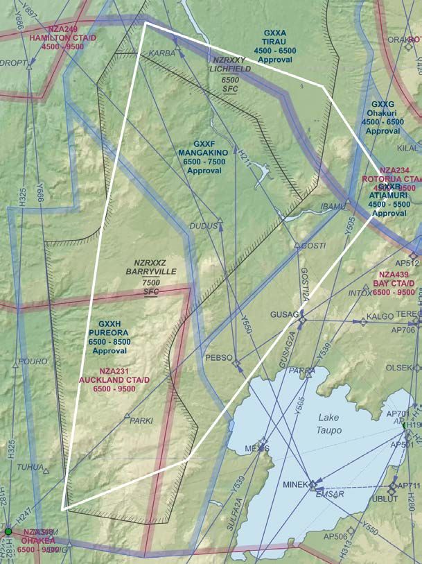
4: West of Taupo area
Proposed change
This petition requests to create three new GA areas west of Taupo, clear of PBN procedures in and out of
Taupo. The proposed areas are nominally GXXF Mangakino, GXXH Pureora. Establishing these areas will also
allow temporary restricted are R299 to be retired.
Reason for change
The controlled airspace to the west of Taupo is relatively low over rugged country. This proposal enables GA
traffic to fly at increased terrain clearance in airspace that is little used by IFR traffic.
The proposed areas are designed to be clear of frequently used IFR routes, allowing normal climb and descent
profiles to Taupo and Hamilton, and leaving low level IFR routes available even when the GAA are active. This
means that GA and glider traffic using the airspace will not impose undue constraints on IFR traffic nor on air
traffic controller time.
The only airspace currently designated for gliding use in the area is temporary restricted area R299. PBN
procedures at Taupo and Rotorua conflict with this area. When R299 is active during the summer Competition
periods, controllers must manually radar vector IFR traffic in and out of Taupo creating a large workload and a
hazard. As a result, during Competition periods, the restricted area is currently unreasonable to use. The
proposed GAA resolve this problem by creating designated airspace away from frequently used IFR routes. It is
proposed (section 5 below) to re-align temporary restricted areas within these GAA such that the temporary
restricted areas when active have no additional effect on IFR traffic or controller workload. These GAA are part
of that design.
All of the proposed volumes are in airspace that has little or no use by IFR traffic.
Description of proposed change
Exi
sti
ng
R2
99
The proposed GAA are shown in blue outline, controlled airspace in red outline. 3nm clearance from PBN
procedures shown yellow. IFR SID/STAR shown for Taupo runway 17 and Hamilton 36R.
26 March 2021 Revision 8 Page 12 of 27Airways – GNZ Waikato airspace collaboration 2018 NZGXXF Mangakino NZGXXF Mangakino abuts NZGXXA to the north, is 3nm clear of Hamiton SIDS between BILOK and DROPT, clear of the route from DROPT along Y666, and runs below the Taupo departures via DUDUS used by IFR traffic from Taupo to Auckland. The Eastern boundary of GXXF is 3nm clear of PEBSO, enabling ATC to issue conditional departure clearances for flights from Taupo, requiring aircraft to achieve 8000ft at PEBSO which is a normal climb gradient. Airways intend to add a point to the departure procedure from Taupo runway 35 to allow a similar normal climb clear of the proposed area. The area enables glider flight south from Maungatautari, or the hills near Atiamuri, across the gap to the ranges west of lake Taupo without conflicting with IFR traffic from Hamilton or Taupo. The proposed GXXF Mangakino GAA would be activated “by approval”. NZGXXH Pureora NZGXXH Pureora abuts NZGXXF, being 3nm clear of the Taupo departures via DUDUS. It is also clear of the route south from DROPT on Y666 until 35nm from Hamilton VOR/DME, allowing a normal climb gradient on this route. To the west, it runs under Y666 and stops 3nm from Y666 centreline. To the south it coincides with the boundary of controlled airspace NZA231 and NZA234. To the east it is 3nm clear of the SULFA2A arrival to Taupo. This area provides increase safety for gliders operating on the hills west of lake Taupo by providing increased clearance from terrain in a volume not frequented by IFR traffic. The proposed GXXH Pureora GAA would be activated “by approval”. Summary of consultation Airways supports this proposal as it improves controller productivity. It enables controllers to keep IFR traffic clear of the GA areas using conditional clearances based on normal IFR climb and descent gradients without requiring radar vectoring. This is a distinct productivity advantage for Airways. It also improves IFR flight predictability and efficiency by enabling full use of PBN procedures. These departures are used not only by scheduled public transport operators but also by itinerant private jets. Airways perceives a definite safety improvement by enabling unfamiliar operators to follow IFR procedures without vectoring. Airways advises that these GA areas can be activated “by approval”. Taupo Airport were unaware that a previous problem existed with the airspace and happy that Airways and GNZ were taking a proactive step to improve flight efficiency for airport users. In 2018 Mt Cook Airlines understood the rationale behind designing the GAA to be clear of frequently used IFR procedures and accept the design. GNZ has consulted with Air NZ again in March 2021, particularly to check the descent gradient on the GOSTI2A arrival, and has moved the proposed boundary closer to GOSTI to allow 6.25nm on the GOSTI GUSAG track for 2000ft descent to the desired profile altitude 6000ft at GUSAG. GNZ support this proposal as it re-enables use of the airspace after the introduction of PBN. It also improves flight safety in the area by increasing the available clearance above terrain. Additionally, in conjunction with the temporary restricted areas being requested, the design enables glider competitions to proceed with much reduced complexity and administration burden, and no additional impact on IFR airspace users. Impact of proposed change The change has little impact on IFR traffic, and improves safety of GA and glider operations west of Lake Taupo by enabling increased height above terrain, and re-enables gliding access to the area without constraining IFR traffic or imposing ATS workload. Affected airspace New: NZGXXF Mangakino, NZGXXH Pureora. Airspace Description Description of the new airspaces in the format used by the national airspace register is in appendix A. 26 March 2021 Revision 8 Page 13 of 27
Airways – GNZ Waikato airspace collaboration 2018

4: Firth of Thames
Proposed change
A new GAA, nominally NZGXXN is proposed at the southern end of the Firth of Thames.

Reason for change
This GAA will improve safety for gliders transiting between the Coromandel Peninsula and the western edge of
the Firth of Thames or GXXM Waerenga by enabling glides from altitude, and the use of a convergence that
often builds just offshore of the southern shore of the Firth of Thames, in an area with little effect on IFR
traffic and largely without IFR routes.

Description of proposed change

GXXN Miranda adjoins GXXM Waerenga and is contained within NZA145 south of a line between the southern
corner of NZA143 and the point at which NZA145 crosses the coastline of the Coromandel Peninsula. GXXN has
lower level 4500 amsl, upper level 5500 amsl, and is activated “by approval”.

Summary of consultation

GNZ consulted with Airways in March 2021. Airways has no objection to establishing this GAA, provided that
the upper limit is no higher than 5500ft amsl. The GAA would be activated “by approval”.

Impact of proposed change

This GAA has little impact on IFR traffic, and will enhance the safety of gliding operations by enabling operation
at higher altitudes with improved access to suitable landing sites.

Airspace Description
Description of the new airspaces in the format used by the national airspace register is in appendix A.

26 March 2021                                       Revision 8                                    Page 14 of 27
Airways – GNZ Waikato airspace collaboration 2018

5: Temporary Contest Airspace
Proposed change
To enable gliding events (club, regional and national contests) it is proposed that future temporary airspace
applied for annually for the gliding contest season will be aligned with the design in this petition. The previous
temporary SUA NZR298, NZR298A, NZR299, and NZG481 will be retired and one new GAA and three new
temporary restricted areas, nominally GXXG Ohakuri, RXXZ Barryville, RXXY Lichfield, RXXX Thames used
instead. All new areas are harmonised with the other changes in this petition to minimise the impact on any
other operations.

Reason for change
These areas are proposed in order to minimise the airspace required specifically for gliding contests, minimise
the impact of contests on other air traffic, reduce an ATS human factors risk when active, and be long lasting.
This change request seeks to move the restricted areas such the interference with IFR traffic is minimised.
With the introduction of PBN, the existing restricted areas have become incompatible with IFR procedures at
Tauranga and Taupo. NZR298 conflicts with approach and departure to Tauranga for RPT traffic to and from
Auckland, and the TAYLA hold for Hamilton traffic. NZR299 is in conflict with all PBN procedures between
Taupo and Auckland. To minimise the impact of the restricted areas on other traffic the proposal locates the
restricted areas largely within GAA which are already so organised. The exception to this design principle is the
proposed NZRXXX Thames which is not enclosed entirely within GAA but is specifically designed to enable IFR
operations around it with reasonable flight efficiency and ATS workload.
The restricted areas have the function of reducing ATS workload. The restricted areas exist for the purpose of
enabling glider cloud flying under rule 104.53(1) without requiring each glider pilot to check with ATC every 15
minutes that no IFR traffic is in the area, as required by rule 104.53(2). These restricted areas are crucial for
removing this radio traffic during glider contests when dozens of gliders can be airborne.
The restricted areas have minimal impact on other operators. They prohibit IFR traffic but remain open to all
VFR traffic without notice to the area administrator, normally a gliding Contest Director (CD), and are relatively
rarely used (afternoons on some contest days depending on weather, which will be predominantly VMC).
The alignment with GAA also largely removes a human factors risk for ATC when interpreting maps on the ATC
display. Current ATS practice is to separate IFR traffic from GAA by 3nm laterally and 500ft vertically. ATS also
separate IFR traffic from restricted areas by 6nm laterally and 1000ft vertically. The proposed restricted areas
therefore are located 500ft lower than the top of GAA and 3nm inside the GAA lateral boundary so that the
ATC separation boundary for both the GAA and the restricted area are the same. The common separation
boundary simplifies the ATS task. The enclosing GAA would be activated when the restricted areas are active.
The three restricted areas help minimise the airspace required for gliding contests. Using a combination of
three temporary restricted areas gives gliding contest directors more flexibility to activate the minimum
airspace required for contests, depending on the gliding task routing of the day.
The proposed temporary GAA, GXXG Ohakuri, is the residual segment of the previous temporary GAA NZG481
Tokoroa, the remainder of which is no longer needed after the requested airspace changes. This temporary
GAA would be activated by ATC approval to enable regional and national gliding contests, under conditions
agreed with Airways in the GNZ-Airways MOU.
The four SUA planned for competition use simplify the administrative effort and the content of the resulting
AIP SUP. This also means that the temporary airspace will be simplified and clearer for pilots and operators.

26 March 2021                                       Revision 8                                     Page 15 of 27
Airways – GNZ Waikato airspace collaboration 2018

Description of proposed change
Overview
Three restricted areas are intended, described more fully on following pages:
    •   NZRXXZ BARRYVILLE is contained within NZGXXH and NZGXXF and would normally require both GAA
        to be active.
    •   NZRXXY LICHFIELD is contained entirely within NZGXXF, NZGXXA and NZG254 and would normally
        require those GAA to be activated.
    •   NZRXXX Thames replaces R298 and R298A and extends beyond NZG254 to enable glider contests to
        use lift along the Coromandel Peninsula. It is better aligned with IFR and ATS needs than its
        predecessors R298 and R298A.

                        General location of three proposed temporary restricted areas

26 March 2021                                     Revision 8                                  Page 16 of 27
Airways – GNZ Waikato airspace collaboration 2018
NZRXXX Thames
Exi
stin
g R29
8
Exist
ing R
298A
White lines show the existing NZR298 and NZR298A boundaries, black outlined area is the proposed
replacement NZRXXX Thames.
NZRXXX Thames replaces both NZR298 and NZR298A. The southern end of NZRXXX is within NZG254 laterally
as previously described but extends above it to 7000ft. The northern end is 7nm clear of the TAYLA hold to the
west, and 6nm clear of WAIHI to the east. While NZRXXX is active, Airways intend to route turbo prop traffic
between Tauranga and Auckland via WAIHI, a route which is shorter and provides improved flight efficiency
and normal climb and descent gradients. NZRXXX is extended to access lift along the Coromandel Peninsula in
airspace below IFR traffic and not used by IFR traffic or IFR routes. This airspace would be activated by NOTAM
for use during gliding competitions.
NZRXXY Lichfield
NZRXXY is as depicted in the overview above. It is completely contained within three GAA areas and creates no
additional constraint for IFR traffic in practice, as IFR traffic generally do not use active GAA airspace. This area
would be activated by NOTAM provided that ATC approval was available for NZGXXA and NZHXXF.
26 March 2021 Revision 8 Page 17 of 27Airways – GNZ Waikato airspace collaboration 2018
NZRXXZ Barryville
Ex
ist
ing
R2
99
White line is the existing NZR299. Black shaded lines show the boundaries of the replacement NZRXXZ
Barryville.
NZRXXZ Barryville is 3nm inside the lateral boundaries of NZGXXH and NZGXXF, and replaces R299. It therefore
creates no new constraints for IFR traffic, and could be activated by NOTAM from time to time for gliding
events when conditions and demand exist. NZGXXF and NZGXXH would always be activated when NZRXXZ was
active.
GAA active in combination with restricted area
To minimise the ATC human factors risk when interpreting ATC map displays, the surrounding GAA would be
activated whenever each restricted area is active. This requirement will be added to the MOU between Gliding
NZ and Airways for glider contest management.
Restricted area GAA activated
RXXZ Tiroa GXXH Pureora and GXXF Mangakino
RXXY Lichfield GXXF Mangakino, GXXA Tirau, G254 Matamata
RXXY Thames G254 Matamata
The table does not imply that restricted only one restricted area would be active at once. It is envisaged that
adjacent restricted areas may be active simultaneously during glider contests, however, in any case the GAA
enclosing the restricted area would also be activated for traffic management and human factors reasons.
26 March 2021 Revision 8 Page 18 of 27Airways – GNZ Waikato airspace collaboration 2018
NZGXXG Ohakuri
Exi
stin
g
G48
1
White line indicates previous G481 boundary, Blue hash outline shows GXXG extent.
NZGXXB omitted for clarity.
NZGXXG Ohakuri retains the vestigial component of NZG481 Tokoroa, between NZGZZA and NZGXXC. Its north
eastern boundary is 17NM Rotorua VOR/DME; the other boundaries align with adjacent airspace. It would be
activated only for regional/national gliding competitions by approval of ATC.
Summary of consultation
Airways strongly supports the proposed restricted areas for the reasons mentioned: the reduction in human
factors risk due to mis-interpreting displayed maps is regarded very positively. No new traffic management
issues arise for NZRXXZ and NZRXXY. In the case of NZRXXX, Airways is confident that traffic management for
Hamilton (possibly using the TAYLA hold) and for Tauranga across the restricted area can be managed with
good flight efficiency and expediency, and reasonable climb and descent gradients.
Gliding NZ support this proposal. GNZ are more comfortable with airspace that does not impact excessively on
IFR traffic during competitions, and welcome the flexibility that the three-part design allows. The loss of
airspace around PEBSO is regrettable but understandable and accepted.
Other operators spoken to understand the reason for the restricted areas designated for glider cloud flying as
an obvious necessity for the sake of controller and radio time. Mt Cook airlines on behalf of Air New Zealand
link companies accept explanations of the proposed procedures by Airways as being superior to the status quo
on routes to Tauranga, and to Taupo. In general, L3 supports the need for temporary airspace during gliding
contests and Gliding NZ appreciate their support in this regard.
Impact of proposed change
No significant impact on IFR or VFR traffic is created by NZRXXZ or NZRXXY. NZRXXX requires regular public
transport flights to and from Tauranga to use an alternative route vectored by ATC. Airways planned
procedures are not likely to degrade flight efficiency nor add unacceptable ATC workload when the area is
active.
26 March 2021 Revision 8 Page 19 of 27Airways – GNZ Waikato airspace collaboration 2018 Affected airspace Remove: NZR298, NZR298A, NZR2999 Create: NZRXXX Thames, NZRXXY Lichfield, NZRXXZ Barryville, NZGXXG Ohakuri. Airspace Description Description of the proposed temporary restricted airspaces in the format used by the national airspace register is in appendix B. 26 March 2021 Revision 8 Page 20 of 27
Airways – GNZ Waikato airspace collaboration 2018

Appendix A Proposed Airspace Definitions
Permanent designated airspace

        NZANR - Part 71 - General Aviation Areas (GAA)                                                                                                                    Page 1 of 1

                                                                       NZANR - Part 71 - General Aviation Areas (GAA)
                                                         NOTES: (1) Upper/Lower Limit is expressed in FT (AMSL) or FL (Flight Level)
          Identifier                       Name          Upper Limit Lower Limit Hrs Remark to working hours                           Remarks

                                                                                     [ATC Authority:] Bay Approach
          NZGXXA              TIRAU                      6500    FT    4500     FT                                                     [Active:] By ATC approval
                                                                                     [Frequency:] 125.3 MHz

                                                                                     [ATC Authority:] Bay Approach
          NZGXXB              ATIAMURI                   5500    FT    4500     FT                                                     [Active:] By ATC approval
                                                                                     [Frequency:] 119.5 MHz

                                                                                     [ATC Authority:] Bay Approach
          NZGXXC              MIHI                       6500    FT    4500     FT                                                     [Active:] By ATC approval
                                                                                     [Frequency:] 119.5 MHz

                                                                                     [ATC Authority:] Bay Approach
          NZGXXD              OHAAKI                     5500    FT    4500     FT                                                     [Active:] By ATC approval
                                                                                     [Frequency:] 119.5 MHz

                                                                                     [ATC Authority:] Bay Approach
          NZGXXE              ROTOMAHANA                 6500    FT    LL CA                                                           [Active:] By ATC approval
                                                                                     [Frequency:] 119.5 MHz

                                                                                     [ATC Authority:] Bay Approach
          NZGXXF              MANGAKINO                  7500    FT    6500     FT                                                     [Active:] By ATC approval
                                                                                     [Frequency:] 119.5 MHz

                                                                                     [ATC Authority:] Bay Approach
          NZGXXH              PUREORA                    8500    FT    6500     FT                                                     [Active:] By ATC approval
                                                                                     [Frequency:] 119.5 MHz

                                                                                     [ATC Authority:] Auckland Approach
          NZGXXM              WAERENGA                   5500    FT    4500     FT                                                     [Active:] By notification to ATC
                                                                                     [Frequency:] 124.3 MHz

                                                                                     [ATC Authority:] Auckland Approach
          NZGXXN              MIRANDA                    6500    FT    4500     FT                                                     [Active:] By ATC approval
                                                                                     [Frequency:] 124.3 MHz

                                                                   *** SEE AIRSPACE BOUNDARY DESCRIPTION BELOW ***

26 March 2021                                               Revision 8                                               Page 21 of 27
Airways – GNZ Waikato airspace collaboration 2018
NZANR - Part 71 - General Aviation Areas (GAA) Page 1 of 3
NZANR - Part 71 - GAA boundaries
Boundary Line Types CIR (Circle) , CWA (clockwise Arc) , CCA (Counterclockwise Arc) , GRC (Great Circle) , RHL (Rhumbline) , FNT (geoborder i.e. a line following the road, etc)
Identifier Sequence Remarks Latitude Longitude Type Arc latitude Arc longitude Arc radius
NZGXXA 1 375155.1S 1755631.3E GRC
NZGXXA 2 380509.0S 1755918.9E CCA 380743.1S 1760116.9E 3 nm
NZGXXA 3 380913.3S 1755759.3E GRC
NZGXXA 4 381055.7S 1755914.3E GRC
NZGXXA 5 (Rotorua VOR/DME) 382431.2S 1755651.5E CWA 380628.9741S 1761850.1520E 25 nm
NZGXXA 6 381508.0S 1754905.0E CWA
NZGXXA 7 380838.0S 1753301.0E GRC
NZGXXA 8 380852.0S 1752716.1E GRC
NZGXXA 9 (BILOK) 380610.9S 1752910.0E CCA 380443.0S 1752551.0E 3 nm
NZGXXA 10 380532.4S 1752930.2E GRC
NZGXXA 11 (KAPLO) 375500.4S 1753317.7E CCA 375411.0S 1752939.0E 3 nm
NZGXXA 12 375411.9S 1753326.4E GRC
NZGXXA 13 374725.8S 1753342.7E GRC
NZGXXA 14 375004.5S 1753929.7E GRC
NZGXXA 15 375221.4S 1755033.2E GRC
NZGXXB 1 382201.2S 1760747.6E GRC
NZGXXB 2 (Rotorua VOR/DME) 382853.7S 1760446.4E CWA 380628.9741S 1761850.1520E 20.5 nm
NZGXXB 3 382431.2S 1755651.5E GRC
NZGXXB 4 (Rotorua VOR/DME) 381837.5S 1755753.5E CCA 380628.9741S 1761850.1520E 25 nm
NZGXXB 5 382246.6S 1760302.3E GRC
NZGXXC 1 382110.5S 1762246.3E GRC
NZGXXC 2 (Rotorua VOR/DME) 383058.0S 1762524.6E CWA 380628.9741S 1761850.1520E 25 nm
NZGXXC 3 382853.7S 1760446.4E GRC
NZGXXC 4 382201.2S 1760747.6E GRC
NZGXXC 5 (Rotorua VOR/DME) 382020.9S 1761132.3E CCA 380628.9741S 1761850.1520E 15 nm
NZGXXC 6 382113.2S 1761510.3E GRC
NZGXXC 7 381639.2S 1761818.4E GRC
NZGXXC 8 A line following SH5 From 381409.2S 1761800.0E FNT
NZGXXC 9 (Waiotapu) 382023.4S 1762149.5E GRC
26 March 2021 Revision 8 Page 22 of 27Airways – GNZ Waikato airspace collaboration 2018
NZANR - Part 71 - General Aviation Areas (GAA) Page 2 of 3
NZANR - Part 71 - GAA boundaries
Boundary Line Types CIR (Circle) , CWA (clockwise Arc) , CCA (Counterclockwise Arc) , GRC (Great Circle) , RHL (Rhumbline) , FNT (geoborder i.e. a line following the road, etc)
Identifier Sequence Remarks Latitude Longitude Type Arc latitude Arc longitude Arc radius
NZGXXD 1 382110.5S 1762246.3E GRC
NZGXXD 2 (Rotorua VOR/DME) 383058.0S 1762524.6E CWA 380628.9741S 1761850.1520E 25 nm
NZGXXD 3 382853.7S 1760446.4E GRC
NZGXXD 4 382201.2S 1760747.6E GRC
NZGXXD 5 (Rotorua VOR/DME) 382020.9S 1761132.3E CCA 380628.9741S 1761850.1520E 15 nm
NZGXXD 6 382113.2S 1761510.3E GRC
NZGXXD 7 381639.2S 1761818.4E GRC
NZGXXD 8 A line following SH5 From 381409.2S 1761800.0E FNT
NZGXXD 9 (Waiotapu) 382023.4S 1762149.5E GRC
NZGXXE 1 (Rotorua VOR/DME) 380341.7S 1763730.2E CWA 380628.9741S 1761850.1520E 15 nm
NZGXXE 2 382110.5S 1762246.3E GRC
NZGXXE 3 (Waiotapu);A line following SH5 from 382023.4S 1762149.5E FNT
NZGXXE 4 381409.2S 1761800.0E GRC
NZGXXE 5 380923.0S 1762550.0E GRC
NZGXXE 6 380511.3S 1762733.1E GRC
NZGXXF 1 (Rotorua VOR/DME) 381508.0S 1754905.0E CWA 380628.9741S 1761850.1520E 25 nm
NZGXXF 2 382431.2S 1755651.5E GRC
NZGXXF 3 (PEBSO) 383720.0S 1754150.9E CCA 383926.7S 1754434.1E 3 nm
NZGXXF 4 383818.6S 1754101.5E GRC
NZGXXF 5 383906.4S 1754038.3E GRC
NZGXXF 6 382802.8S 1753837.0E GRC
NZGXXF 7 381609.6S 1752402.6E GRC
NZGXXF 8 381352.7S 1752343.0E GRC
NZGXXF 9 380852.0S 1752716.1E GRC
NZGXXF 10 380838.0S 1753301.0E GRC
26 March 2021 Revision 8 Page 23 of 27Airways – GNZ Waikato airspace collaboration 2018
NZANR - Part 71 - General Aviation Areas (GAA) Page 3 of 3
NZANR - Part 71 - GAA boundaries
Boundary Line Types CIR (Circle) , CWA (clockwise Arc) , CCA (Counterclockwise Arc) , GRC (Great Circle) , RHL (Rhumbline) , FNT (geoborder i.e. a line following the road, etc)
Identifier Sequence Remarks Latitude Longitude Type Arc latitude Arc longitude Arc radius
NZGXXH 1 382802.8S 1753837.0E GRC
NZGXXH 2 (PEBSO) 383952.4S 1754046.7E CCA 383926.7S 1754434.1E 3 nm
NZGXXH 3 384107.5S 1754123.7E GRC
NZGXXH 4 384451.1S 1754436.3E GRC
NZGXXH 5 385653.0S 1754012.2E GRC
NZGXXH 6 385718.3S 1753437.3E GRC
NZGXXH 7 385555.1S 1752219.3E GRC
NZGXXH 8 (Hamilton VOR/DME) 382555.4S 1751745.4E CCA 375057.3480S 1752018.77E 35 nm
NZGXXH 9 382545.0S 1752524.9E GRC
NZGXXH 10 381609.6S 1752402.6E GRC
NZGXXM 1 371009.90S 1751731.40E GRC
NZGXXM 2 371407.60S 1752336.70E GRC
NZGXXM 3 371829.50S 1752614.60E GRC
NZGXXM 4 373047.00S 1751915.00E GRC
NZGXXM 5 373047.70S 1751914.90E GRC
NZGXXM 6 373219.70S 1751408.80E GRC
NZGXXM 7 Ohinewai 372922.50S 1750923.90E GRC
NZGXXM 8 372312.30S 1750122.60E GRC
NZGXXN 1 370717.39S 1753144.40E CWA 370016.30S 1744849.40E 35 nm
NZGXXN 2 371829.50S 1752614.60E GRC
NZGXXN 3 371407.60S 1752336.70E GRC
NZGXXN 4 371009.90S 1751731.40E GRC
*** END OF AIRSPACE BOUNDARY DESCRIPTIONS ***
26 March 2021 Revision 8 Page 24 of 27Airways – GNZ Waikato airspace collaboration 2018
Appendix B Proposed Restricted Area Definitions
NZ Air Navigation Register
Temporary airspace Updated 26 March 2021
NZRXXX Thames, Waikato
All that airspace bounded by a line joining
S 36 54 26.3, E 175 45 34.1;
S 37 14 59.5, E 175 50 25.9; the arc of a 6NM radius centred on
S 37 22 53.2, E 175 55 53.8; (WAIHI), from
S 37 18 17.6, E 175 51 03.4; anticlockwise to
S 37 24 51.7, E 175 48 47.3;
S 37 37 10.6, E 175 54 10.2;
S 37 41 31.3, E 175 52 36.1;
S 37 49 13.6, E 175 52 11.3;
S 37 49 19.6, E 175 50 51.5;
S 37 47 15.9, E 175 40 56.0;
S 37 45 30.3, E 175 37 04.8;
S 37 40 10.1, E 175 35 42.0; the arc of an 8.5 NM radius centred on
S 37 35 28.0, E 175 23 35.7; (TAYLA hold), from
S 37 33 23.9, E 175 34 01.5; anticlockwise to
S 37 27 52.9, E 175 28 33.4;
S 37 23 45.6, E 175 26 54.1;
S 37 14 19.0, E 175 23 10.0;
S 37 09 24.0, E 175 33 01.0;
S 36 55 24.2, E 175 29 31.5;
Upper limit: 7000 ft AMSL
Lower limit: surface
Activity: Daily when advised by NOTAM during daylight hours
gliding operations
Administering Matamata Soaring Centre; PO, Box 100 Matamata, Tim Bromhead
Authority: 027 217 9049
Contest Director: As advised by NOTAM
Conditions of Use: VFR flights may enter and operate within NZRXXX without prior
Administering Authority approval when NZRXXX is active
Effective as defined annually for glider contest season
Temporary Airspace 1
26 March 2021 Revision 8 Page 25 of 27Airways – GNZ Waikato airspace collaboration 2018
NZRXXY Lichfield, Waikato
All that airspace bounded by a line joining
S 37 49 13.6, E 175 52 11.3; the arc of a 6 NM radius centred on
S 38 07 43.1, E 176 01 16.9; from
S 38 04 04.8, E 175 55 14.3; anticlockwise to
S 38 10 44.4, E 175 54 41.8;
S 38 11 32.3, E 175 55 17.5;
S 38 23 10.8, E 175 53 14.6; the arc of a 28 NM radius centred on
S 38 06 29.0, E 176 18 50.2; (Rotorua VOR/DME) from
S 38 24 32.1, E 175 51 39.6; clockwise to
S 38 17 17.3, E 175 46 03.8;
S 38 11 40.4, E 175 32 11.3;
S 38 11 46.8, E 175 29 33.8; the arc of a 6nm radius centred on
S 38 04 43.0, E 175 25 51.0; (BILOK) from
S 38 07 38.7, E 175 32 29.1; anticlockwise to
S 38 06 21.7, E 175 33 09.5; the arc of a 6nm radius centred on
S 37 54 11.0, E 175 29 39.0; (KAPLO) from
S 37 55 49.6, E 175 36 56.5; anticlockwise to
S 37 54 17.3, E 175 37 13.6; the arc of a 3NM radius centred on
S 37 47 26.0, E 175 33 43.0; from
S 37 47 31.8, E 175 37 29.9; clockwise to
S 37 46 49.8, E 175 37 25.4;
S 37 45 30.3, E 175 37 04.8;
S 37 47 15.9, E 175 40 56.0;
S 37 49 19.6, E 175 50 51.5;
Upper limit: 6000 ft AMSL
Lower limit: surface
Activity: Daily when advised by NOTAM during daylight hours
gliding operations
Administering Matamata Soaring Centre; PO, Box 100 Matamata, Tim Bromhead
Authority: 027 217 9049
Contest Director: As advised by NOTAM
Conditions of Use: VFR flights may enter and operate within NZRXXY without prior
Administering Authority approval when NZRXXY is active
Effective as defined annually for glider contest season
2
26 March 2021 Revision 8 Page 26 of 27Airways – GNZ Waikato airspace collaboration 2018
NZRXXZ Barryville, Waikato
All that airspace bounded by a line joining
S 38 11 40.4, E 175 32 11.3; the arc of a 28 NM radius centred on
S 38 06 29.0, E 176 18 50.2; (Rotorua VOR/DME) from
S 38 17 17.3, E 175 46 03.8; anticlockwise to
S 38 24 32.1, E 175 51 39.6; the arc of a 6nm radius centred on
S 38 39 26.7, E 175 44 34.1; (PEBSO) from
S 38 35 17.0, E 175 39 03.3; anticlockwise to
S 38 42 48.2, E 175 38 13.1;
S 38 45 22.3, E 175 40 25.6;
S 38 54 05.2, E 175 37 13.9;
S 38 54 16.6, E 175 34 42.4;
S 38 53 16.5, E 175 25 47.7; the arc of a 38nm radius centred on
S 37 50 57.3, E 175 20 18.7; (Hamilton VOR/DME) from
S 38 28 57.6, E 175 22 03.8; anticlockwise to the arc of a 3nm radius centred on
S 38 25 45.0, E 175 25 24.9; (corner of GXXH) from
S 38 28 44.3, E 175 25 47.7; anticlockwise to
S 38 25 24.8, E 175 29 12.4;
S 38 14 30.0, E 175 27 38.3;
S 38 11 46.8, E 175 29 33.8;
Upper limit: 7000ft AMSL
Lower limit: surface
Activity: Daily when advised by NOTAM during daylight hours
gliding operations
Administering Matamata Soaring Centre; PO, Box 100 Matamata, Tim Bromhead
Authority: 027 217 9049
Contest Director: As advised by NOTAM
Conditions of Use: VFR flights may enter and operate within NZRXXZ without prior
Administering Authority approval when NZRXXZ is active
Effective as defined annually for glider contest season
NZGXXG Ohakuri, Waikato
All that airspace bounded by a line joining
S 38 21 28.9, E 176 09 00.1;
S 38 22 01.2, E 176 07 47.6; the arc of a 25 NM radius centred on
S 38 06 29.0, E 176 18 50.2; (Rotorua VOR/DME) from
S 38 28 53.7, E 176 04 46.4; clockwise to
S 38 24 31.2, E 175 56 51.5; the arc of a 17 NM radius centred on
S 38 06 29.0, E 176 18 50.2; (Rotorua VOR/DME) from
S 38 12 50.7, E 175 58 54.2; anticlockwise
Upper limit: 6500ft
Lower limit: 4500ft
Acitivity: Active during daylight hours by ATC approval (BAY sector) between
20191103 and 20200326 (3 Novemer 2019 and 26 March 2020)
Effective as defined annually for glider contest season
Temporary Airspace 3
26 March 2021 Revision 8 Page 27 of 27You can also read