FLOOD HAZARD AREA ZONING BYLAW - TOWN OF THETFORD, VERMONT - Thetford, VT
←
→
Page content transcription
If your browser does not render page correctly, please read the page content below
TOWN OF THETFORD
FLOOD HAZARD AREA ZONING BYLAW
TOWN OF THETFORD, VERMONT
FLOOD HAZARD AREA ZONING BYLAW
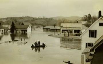
North Thetford during the 1936 flood. The gas station now serves as the Post Office.
Photo courtesy of the Thetford Historical Society
ADOPTED xxx xx, 2021
approved by PC June 15, 2021
Page 1 of 16TOWN OF THETFORD
FLOOD HAZARD AREA ZONING BYLAW
Table of Contents
Article I: Statutory Authorization ............................................................................2
Article II: Statement of Purpose ................................................................................3
Article III: Lands to Which This Bylaw Applies ........................................................3
Article IV: Development Permit Required .................................................................3
Section 1: Prohibited Uses ....................................................................................4
Section 2: Permitted Uses .....................................................................................4
Section 3: Conditional Uses ..................................................................................4
Article V: Procedures ................................................................................................5
Article VI: Base Flood Elevations and Floodway Limits ...........................................6
Article VII: Development Standards ............................................................................6
Section 1: Floodway Areas ...................................................................................6
Section 2: Floodway Fringe Areas ........................................................................7
Article VIII: Duties and Responsibilities of the Zoning Administrator ......................10
Article IX: Variances to the Development Standards ...............................................10
Article X: Warning of Disclaimer of Liability ........................................................11
Article XI: Validity and Severability ........................................................................11
Article XII: Precedence of Bylaw ..............................................................................11
Article XIII: Enforcement and Penalties .....................................................................11
Article XIV: Definitions ..............................................................................................12
Article I: Statutory Authorization
Page 2 of 16TOWN OF THETFORD
FLOOD HAZARD AREA ZONING BYLAW
To effect the purposes of 10 V.S.A. Chapter 32, and in accordance with 24 V.S.A. § 4424,
there is hereby established a zoning bylaw for areas of special flood hazard in the Town of
Thetford, Vermont.
Article II: Statement of Purpose
It is the purpose of this bylaw to:
1. Minimize and prevent the loss of life and property, the disruption of commerce, the
impairment of the tax base, and the extraordinary public expenditures and demands
on public services that result from flooding and other flood related hazards; and
2. Ensure that the design and construction of development in flood and other hazard
areas are accomplished in a manner that minimizes or eliminates the potential for
flood and loss or damage to life and property; and
3. Manage all flood hazard areas designated pursuant to 10 V.S.A. § 753; and
4. Make the state, municipalities, and individuals eligible for federal flood insurance and
other federal disaster recovery and hazard mitigation funds as may be available.
Article III: Lands to Which This Bylaw Applies
This bylaw shall apply to all areas in the Town of Thetford, Vermont identified as areas of
special flood hazard in and on the most current flood insurance studies and maps published
by the Department of Homeland Security (DHS), Federal Emergency Management Agency
(FEMA), National Flood Insurance Program (NFIP), as provided by the Secretary of the
Agency of Natural Resources pursuant to 10 V.S.A. § 753, which are hereby adopted by
reference and declared to be part of this bylaw.
Map Boundaries
If the special flood hazard area boundary determination is disputed, the burden of proof shall
be on the applicant, who may seek a Letter of Map Amendment or Letter of Map Revision
from FEMA, which shall constitute proof. Neither the Zoning Administrator nor the
Development Review Board may determine that an area shown on the FIRM as being in a
floodway or special flood hazard area is incorrect.
Applicants who believe that the FIRM or flood insurance study incorrectly shows their
property in a special flood hazard area or floodway may apply to FEMA to make a change in
the map. The Town or State cannot change the boundaries, but may comment on any
applications to FEMA for map revisions or amendment. Forms to apply to FEMA are
available at http://www.fema.gov/plan/prevent/fhm/frm_form.shtm or by calling (617) 832-
4761.
1
Note: text in shaded areas is explanatory and does not modify this bylaw.
Article IV: Development Permit Required
Page 3 of 16TOWN OF THETFORD
FLOOD HAZARD AREA ZONING BYLAW
A permit is required, to the extent authorized by State law, for all proposed construction or
other development (including mining, dredging, filling, grading, paving, excavation or
drilling operations, storage of equipment or materials, and the placement of manufactured
homes) in areas of special flood hazard.
Section 1: Prohibited Uses
All new residential and non-residential structures in the special flood hazard area are
prohibited, except for liquid or gas storage tanks that will serve an existing structure and will
be adequately anchored to prevent flotation, accessory structures as described in Article VII
Section 2.7 and farm structures covered by the Vermont Agency of Agriculture Accepted
Agricultural Practice Regulations.
Section 2: Permitted uses
Open space permitted uses:
1. Structures used for agricultural purposes, such as general farming, pasture, orchard,
grazing, outdoor plant nurseries, truck farming, and forestry, are regulated by the State
of Vermont. Please contact the VT DEC regional flood manager.
2. Recreational uses, such as parks, camps, picnic grounds, tennis courts, golf courses,
golf driving ranges, archery and shooting ranges, hiking and riding trails, hunting and
fishing areas, game farms, fish hatcheries, wildlife sanctuaries, nature preserves,
swimming areas, and boat launching sites.
3. Residential uses, such as lawns, gardens, parking areas, and play areas.
4. Minor improvement of an existing building that does not extend the structure and
whose cost is less than a “substantial improvement”.
The uses listed in 1-4 above shall be permitted within the special flood hazard area to the
extent that they are not prohibited by any other bylaw and provided that:
a. they do not require the erection of walled structures
b. they do not require storage of materials and equipment,
c. they do not require the borrowing of fill from outside the flood hazard area,
d. they do not require grading,
e. they do not require drilling,
f. they do not require channel modification or relocation,
g. they do not obstruct flood flows,
h. they do not affect the water carrying capacity of the floodway or channel or increase
off site flood damage potential.
Section 3: Conditional Uses
Conditional use approval by the Development Review Board is required for:
1. Substantial improvement of existing buildings in the special flood hazard area,
2. Any fill or excavation in the special flood hazard area,
3. Any grading in the special flood hazard area,
4. Any drilling in the special flood hazard area,
5. Development that will involve channel modification or relocation,
Page 4 of 16TOWN OF THETFORD
FLOOD HAZARD AREA ZONING BYLAW
6. Development that will obstruct flood flows,
7. Development that will affect the water carrying capacity of the floodway or channel
or increase offsite flood damage potential,
8. Development in a floodway, as allowed by Article VII Section 1.1, and
9. Erection of an accessory structure.
Article V: Procedures
1. Applicants shall apply to the Zoning Administrator for a permit on forms approved by
the Development Review Board and accompanied by fees set by the Selectboard.
The applicant must provide all completed certifications needed for the permit review,
as described in Articles VI and VII. In addition to the information requested on the
form, additional information may be required such as surveys, site plans, or drawings
to enable the Zoning Administrator or Development Review Board to adequately
review the proposed land development. An application shall not be considered
complete unless it is signed by the applicant (who must be the owner of record, or the
owner and future developer) and accompanied by the required fees.
2. An application shall not be accepted for review unless it is deemed complete by the
Zoning Administrator. When additional information is requested from the applicant
by the Zoning Administrator in order to consider the permit application complete, and
such information is not presented within 90 days of the request, the application will
expire and be deemed rejected.
3. Prior to issuing a permit, a copy of the application and supporting information shall
be submitted by the Zoning Administrator to the State National Floodplain Insurance
Program Coordinator at the Vermont Agency of Natural Resources, Department of
Environmental Conservation, River Management Section in accordance with 24
V.S.A. §4424. A permit may be issued only following receipt of comments from the
Agency or the expiration of 30 days from the date the application was mailed to the
Agency, whichever is sooner. For any development requiring a hearing before the
Development Review Board, the application shall not be considered complete, nor
shall a hearing be warned until the 30-day comment period has expired.
4. Adjacent communities and the Stream Alteration Engineer at the Vermont Agency of
Natural Resources, Department of Environmental Conservation, River Management
Section shall be notified at least 30 days prior to issuing any permit for the alteration
or relocation of a watercourse and copies of such notification shall be submitted to the
Administrator of the National Flood Insurance Program. Any permit issued shall
assure that the flood carrying capacity within the altered or relocated portion of any
watercourse is maintained.
5. Proposed development shall not be permitted until all necessary permits are received
from those government agencies from which approval is required by Federal, State or
Municipal law. Applicants seeking conditional use approval or a variance must also
provide a Vermont Agency of Natural Resources Project Review Sheet for the
proposal. The Project Review Sheet should identify all State and Federal agencies
from which permit approval is required for the proposal, and shall be filed as a
Page 5 of 16TOWN OF THETFORD
FLOOD HAZARD AREA ZONING BYLAW
required attachment to the Town permit application. The identified permits, or letters
indicating that such permits are not required, shall be submitted to the Zoning
Administrator and attached to the permit application before work can begin.
6. All development and subdivisions shall be reviewed to assure that
a). such proposals comply with the standards in Article VII Sections 1 and 2;
b). the development or subdivision does not increase the risk to emergency
services personnel;
c. potential flood damage is minimized;
d. facilities and utilities such as sewer, gas, electrical, and water systems are
constructed so as to minimize flood damage;
e. and adequate drainage is provided to reduce exposure to flood hazards.
Article VI: Base Flood Elevations and Floodway Limits
1. Where available, base flood elevations and floodway limits (or data from which a
community can designate regulatory floodway limits) provided by the National Flood
Insurance Program in the Flood Insurance Study and accompanying maps shall be
used to administer and enforce this bylaw.
2. In areas where base flood elevations and floodway limits have not been provided by
the National Flood Insurance Program in the Flood Insurance Study and
accompanying maps, base flood elevations and floodway data provided by FEMA or
available from State or Federal agencies or other sources, shall be obtained, or
developed by the applicant, using the criteria in item 3 below, and utilized to
administer and enforce this bylaw.
3. Until a regulatory floodway has been designated, no development shall be permitted
in the special flood hazard area unless it is demonstrated that the cumulative effect of
the proposed development, when combined with all other existing development and
anticipated development will not increase the water surface elevation of the base
flood more than 0.0 feet at any point within the community. The demonstration that
this condition is met requires a certification from a licensed professional engineer that
hydrologic and hydraulic analyses have been performed in accordance with standard
engineering practice, and must include sufficient documentation to verify the results.
Article VII: Development Standards
Section 1: Floodway Areas
1. Development within the regulatory floodway, as determined by Article VI, is
prohibited. Special exceptions may be made only for minor improvements to
existing structures or to bridges, culverts, roads or stabilization projects. Such
exceptions require conditional use approval prior to permitting and must
comply with the standards in Section 2 of Article VII. No exceptions will be
permitted unless it has been demonstrated through hydrologic and hydraulic
analyses performed in accordance with standard engineering practice by a
Page 6 of 16TOWN OF THETFORD
FLOOD HAZARD AREA ZONING BYLAW
registered professional engineer certifying that the proposed development will
result in no increase in flood levels during the occurrence of the base flood.
2. Junkyards and storage facilities for floatable materials, chemicals, explosives,
flammable liquids, or other hazardous or toxic materials, are prohibited within
the floodway.
Section 2: Floodway Fringe Areas
Floodway fringe areas are special flood hazard areas outside of the floodway.
1. All Development - All development shall be reasonably safe from flooding
and:
a) designed (or modified) and adequately anchored to prevent flotation,
collapse, or lateral movement of the structure during the occurrence of the
base flood,
b) constructed with materials resistant to flood damage,
c) constructed by methods and practices that minimize flood damage, and
d) constructed with electrical, heating, ventilation, plumbing and air
conditioning equipment and other service facilities that are designed
and/or located so as to prevent water from entering or accumulating within
the components during conditions of flooding.
2. Residential Development:
a) Existing buildings to be substantially improved or with lateral addition
that are located in Zones A, A1-30 and AE shall have the lowest floor, includ-
ing basement, elevated to at least two feet above the base flood elevation.
b) Existing manufactured homes to be substantially improved that are:
i. located in a manufactured home park or subdivision, outside of a
manufactured home park or subdivision, in an expansion to an existing
manufactured home park or subdivision, or in a manufactured home
park or subdivision which has incurred substantial damage from a
flood shall be elevated on a permanent foundation such that the lowest
floor of the manufactured home is elevated to two feet above the base
flood elevation and be securely anchored to an adequately anchored
foundation system to resist floatation, collapse, and lateral movement
during the occurrence of the base flood.
ii. located in an existing manufactured home park, where elevating a
replacement home to or above base flood elevation is not possible, the
lowest floor shall be supported by reinforced piers or other foundation
Page 7 of 16TOWN OF THETFORD
FLOOD HAZARD AREA ZONING BYLAW
elements of at least equivalent strength that are no less than 48 inches
in height above grade and be securely anchored to an adequately
anchored system to resist floatation, collapse, and lateral movement.
3. Non-residential Development:
a) Existing buildings to be substantially improved located in Zones A, A1-
30, AE shall have the lowest floor, including basement, elevated to at least
two feet above the base flood elevation, or together with attendant util-
ity and sanitary facilities, be designed so that below the base flood
elevation the structure is watertight with walls substantially imperme- able
to the
passage of water and with structural components having the capability of
resisting hydrostatic and hydrodynamic loads and effects of buoyancy.
b) A permit for a building proposed to be flood proofed shall not be issued
until a registered professional engineer or architect has reviewed the
structural design, specifications and plans, and has certified that the design
and proposed methods of construction are in accordance with accepted
standards of practice for meeting the provisions of this subsection.
4. Subdivisions:
a) New subdivision proposals and other proposed development (including
proposals for manufactured home parks and subdivisions) that are greater
than 50 lots or 5 acres, whichever is the lesser, shall include base flood
elevation data.
b) Subdivisions (including manufactured home parks) shall be designed to
assure that:
i. such proposals minimize flood damage within the flood-prone area,
ii. utilities and facilities, such as sewer, gas, electrical, and water systems
are located and constructed to minimize or eliminate flood damage,
iii. adequate drainage is provided to reduce exposure to flood hazards, and
iv. any lots created can be developed for the intended purposes in
compliance with this bylaw.
5. Enclosed Areas Below the Lowest Floor:
Page 8 of 16TOWN OF THETFORD
FLOOD HAZARD AREA ZONING BYLAW
a) Enclosed areas below the lowest floor which are subject to flooding shall
be used solely for parking of vehicles, building access, or storage and such
a condition shall clearly be stated in any permits.
b) Existing buildings to be substantially improved with fully enclosed areas
below the lowest floor that are subject to flooding shall be designed to
automatically equalize hydrostatic flood forces on exterior walls by
allowing for the entry and exit of floodwaters.
c) Designs for meeting this requirement must either be certified by a
registered professional engineer or architect or meet or exceed the
following minimum criteria: A minimum of two openings having a total
net area of not less than one square inch for every square foot of enclosed
area subject to flooding shall be provided. The bottom of all openings
shall be no higher than one foot above grade. Openings may be equipped
with screens, louvers, valves, or other coverings or devices provided that
they permit the automatic entry and exit of floodwaters.
6. Recreational Vehicles: Recreational Vehicles placed on sites in special flood
hazard areas shall either:
a) be on the site for fewer than 180 consecutive days,
b) be fully licensed and ready for highway use, or
c) be permitted in accordance with the elevation and anchoring requirements
for “manufactured homes” in Section 2.2(b) of Article VII.
7. Accessory Structures: small accessory buildings that represent a minimal
investment need not be elevated to the base flood elevation provided the
structure meets the following requirements:
a) The structure must only be used for parking or storage,
b) The structure must have the required openings to allow floodwaters in and
out,
c) The structure must be constructed using flood resistant materials below the
Base Flood Elevation,
d) The structure must be adequately anchored to resist flotation, collapse, and
lateral movement, and
e) All building utility equipment including electrical and heating must be
elevated or flood proofed.
8. Water Supply Systems: New and replacement water supply systems shall be
designed to minimize or eliminate infiltration of flood waters into the systems.
Page 9 of 16TOWN OF THETFORD
FLOOD HAZARD AREA ZONING BYLAW
9. Sanitary Sewage Systems: New and replacement sanitary sewage systems
shall be designed to minimize or eliminate infiltration of flood waters into the
systems and discharges from the systems into flood waters and shall include
a backflow preventer valve to prevent septic water from re-entering the
building drainage system.
10. On-Site Waste Disposal Systems: On-site waste disposal systems shall be
located to avoid impairment to them or contamination from them during
flooding.
11. Watercourse Carrying Capacity: The flood and sediment carrying capacity
within any altered or relocated portion of a watercourse shall be maintained.
The demonstration that this condition is met requires a certification from a
licensed professional engineer that hydrologic and hydraulic analyses have
been performed in accordance with standard engineering practice, and must
include sufficient documentation to verify the results.
12. Private Roads and/or Driveways: Private roads and/or driveways requiring fill
in the special flood hazard area, apart from normal maintenance, are
prohibited. Any habitable structures or critical facilities (for example:
hazardous waste facilities, nuclear power plants, hospitals, police and fire
stations) must be accessible to vehicles, including emergency vehicles, by a
roadway that will not be submerged during a base flood.
Article VIII: Duties and Responsibilities of the Zoning Administrator
The Zoning Administrator shall maintain a record of:
1. All permits issued and denied for development in areas of special flood hazard;
2. The elevation (consistent with the datum of the elevation on the NFIP maps for the
community) of the lowest floor, including basement, of all new or substantially
improved buildings;
3. The elevation (consistent with the datum of the elevation on the NFIP maps for the
community) to which buildings have been flood proofed;
4. All flood proofing certifications required under this bylaw; and
5. All variance actions, including justification for their issuance.
Article IX: Variances to the Development Standards
Variances shall be granted by the Development Review Board only in accordance with 24
V.S.A. § 4469 and in accordance with the criteria for granting variances found in 44 CFR,
Section 60.6, of the National Flood Insurance Program regulations.
Page 10 of 16TOWN OF THETFORD
FLOOD HAZARD AREA ZONING BYLAW
Article X: Warning of Disclaimer of Liability
This bylaw does not imply that land outside of the areas of special flood hazard or land use
permitted within such districts will be free from flooding or flood damages. This bylaw shall
not create liability on the part of the Town of Thetford or any town official or employee
thereof for any flood damages that result from reliance on this bylaw or any administrative
decision lawfully made thereunder.
Article XI: Validity and Severability
If any portion of this bylaw is held unconstitutional or invalid by a competent court, the
remainder of this bylaw shall not be affected.
Article XII: Precedence of Bylaw
The provisions of this bylaw shall not in any way impair or remove the necessity of
compliance with any other applicable bylaws. Where this bylaw imposes a greater
restriction, the provisions of this bylaw shall take precedence.
Article XIII: Enforcement and Penalties
It shall be the duty of the Zoning Administrator to enforce the provisions of this bylaw.
Whenever any development occurs contrary to this bylaw, the Zoning Administrator shall
notify the alleged offender of the violation by certified mail to correct the violation. No
action may be brought unless the alleged offender has had at least a seven-day warning
notice by certified mail. An action may be brought without the seven-day notice and
opportunity to cure if the alleged offender repeats the violation after the seven-day notice
period and within the next succeeding twelve months. The seven-day warning notice shall
state that a violation exists, that the alleged offender has an opportunity to cure the violation
within the seven days, that failure to cure may result in loss of flood insurance, and that the
alleged offender will not be entitled to an additional warning notice for a violation occurring
after the seven days and within the next succeeding 12 months.
If the violation is not remedied within 7 days, or appealed, the Zoning Administrator shall
file a copy of the notice of alleged violation in the municipal land use permit files, with the
Town Clerk for filing in the land records, and shall also mail a copy to the alleged violator,
the state NFIP Coordinator and the Administrator of the National Flood Insurance Program.
§1316 of the National Flood Insurance Act of 1968, as amended, authorizes FEMA to deny
flood insurance to a property declared by a community to be in violation of their flood hazard
area regulations. The notice shall consist of: (a) the name of the property owner and address
or legal description of the property sufficient to confirm its identity or location, (b) a clear
and unequivocal declaration that the property is in violation of a cited State or local law,
regulation, or bylaw, (c) a clear statement that the public body making the declaration has
authority to do so and a citation to that authority, (d) evidence that the property owner has
been provided notice of the violation and the prospective denial of insurance, and (e) a clear
statement that the declaration is being submitted pursuant to §1316 of the National Flood
Insurance Act of 1968, as amended.
Page 11 of 16TOWN OF THETFORD
FLOOD HAZARD AREA ZONING BYLAW
In accordance with 24 V.S.A., §4451, any person who is found to have violated this bylaw
shall be fined by the court not more than $100.00 for each offense. No action may be brought
under this section unless such notice as required above has been given. In default of payment
of the fine, the violator shall pay double the amount of the fine. Each day that a violation is
continued shall constitute a separate offense. All fines collected for the violation of bylaws
shall be paid over to the Town of Thetford.
Article XIV: Definitions
Base Flood means the flood having a one percent chance of being equaled or exceeded in
any given year.
Base Flood Elevation (BFE) means the height of the base flood, usually in feet, in relation
to the National Geodetic Vertical Datum of 1929, the North American Vertical Datum of
1988, or other datum referenced in the Flood Insurance Study report, or average depth of the
base flood, usually in feet, above the ground surface.
Basement means any area of the building having its floor elevation below ground level on all
sides.
Community means the Town of Thetford.
Development means any man-made change to improved or unimproved real estate, including
but not limited to buildings or other structures, mining, dredging, filling, grading, paving,
excavation or drilling operations or storage of equipment or materials.
Existing manufactured home park or subdivision means a manufactured home park or
subdivision for which the construction of facilities for servicing the lots on which the
manufactured homes are to be affixed (including, at a minimum, the installation of utilities,
the construction of streets, and either final site grading or the pouring of concrete pads) is
completed before the effective date of the floodplain management regulations adopted by a
community.
Expansion to an existing manufactured home park or subdivision means the preparation of
additional sites by the construction of facilities for servicing the lots on which the
manufactured homes are to be affixed (including the installation of utilities, the construction
of streets, and either final site grading or the pouring of concrete pads).
Flood means (a) A general and temporary condition of partial or complete inundation of
normally dry land areas from: the overflow of inland or tidal waters; the unusual and rapid
accumulation or runoff of surface waters from any source; and mudslides which are
proximately caused by flooding and are akin to a river of liquid and flowing mud on the
surfaces of normally dry land areas, as when earth is carried by a current of water and
deposited along the path of the current. (b) The collapse or subsidence of land along the
shore of a lake or other body of water as a result of erosion or undermining caused by waves
or currents of water exceeding anticipated cyclical levels or suddenly caused by an unusually
high water level in a natural body of water, accompanied by a severe storm, or by an
Page 12 of 16TOWN OF THETFORD
FLOOD HAZARD AREA ZONING BYLAW
unanticipated force of nature, such as flash flood or abnormal tidal surge, or by some
similarly unusual and unforeseeable event which results in flooding.
Flood Insurance Rate Map (FIRM) means an official map of a community, on which the
Federal Insurance Administrator has delineated both the special hazard areas and the risk
premium zones applicable to the community.
Flood Insurance Study means an examination, evaluation and determination of flood
hazards and, if appropriate, corresponding water surface elevations or an examination,
evaluation and determination of mudslide (i.e., mudflow) and /or flood related erosion
hazards.
Floodplain or flood-prone area means any land area susceptible to being inundated by water
from any source (see definition of “flood”).
Flood proofing means any combination of structural and non-structural additions, changes,
or adjustments to structures which reduce or eliminate flood damage to real estate or
improved real property, water and sanitary facilities, structures and their contents.
Flood resistant materials are discussed in FEMA Technical Bulletin 2-93, Flood-Resistant
Materials Requirements for Buildings Located in Special Flood Hazard Areas.
Floodway means the channel of a river or other watercourse and the adjacent land areas that
must be reserved in order to discharge the base flood without cumulatively increasing the
water surface elevation more than one foot at any point.
Floodway Fringe Area means special flood hazard areas outside of the floodway.
Grading means shaping or the changing the elevation or profile of the land, excluding
normal maintenance of private roads and/or driveways.
Historic Structure means any structure that is: (a) Listed individually in the National
Register of Historic Places (a listing maintained by the Department of the Interior) or
preliminarily determined by the Secretary of the Interior as meeting the requirements for
individual listing on the National Register; (b) Certified or preliminarily determined by the
Secretary of the Interior as contributing to the historical significance of a registered historic
district or a district preliminarily determined by the Secretary to qualify as a registered
historic district; (c) Individually listed on a state inventory of historic places in states with
historic preservation programs which have been approved by the Secretary of the Interior; or
(d) Individually listed on a local inventory of historic places in communities with historic
preservation programs that have been certified either: (i) By an approved state program as
determined by the Secretary of the Interior or (ii) Directly by the Secretary of the Interior in
states without approved programs.
Lowest Floor means the lowest floor of the lowest enclosed area, including basement. An
unfinished or flood resistant enclosure, usable solely for parking of vehicles, building access
or storage in an area other than a basement area is not considered a building’s lowest floor;
provided, that such enclosure is not built so as to render the structure in violation of the
Page 13 of 16TOWN OF THETFORD
FLOOD HAZARD AREA ZONING BYLAW
applicable non-elevation design requirements of 44 CFR 60.3 of the National Flood
Insurance Program.
Manufactured home means a structure, transportable in one or more sections, which is built
on a permanent chassis and is designed for use with or without a permanent foundation when
attached to the required utilities. The term “manufactured home” does not include a
“recreational vehicle”.
Manufactured home park or subdivision means a parcel (or contiguous parcels) of land
divided into two or more manufactured home lots for rent or sale.
New construction means, for the purposes of determining insurance rates, structures for
which the “start of construction” commenced on or after the effective date of an initial FIRM
or after December 31, 1974, whichever is later, and includes any subsequent improvements
to such structures. For floodplain management purposes, new construction means structures
for which the start of construction commenced on or after the effective date of the floodplain
management regulation adopted by a community and includes any subsequent improvements
to such structures.
New manufactured home park or subdivision means a manufactured home park or
subdivision for which the construction of facilities for servicing the lots on which the
manufactured homes are to be affixed (including at a minimum, the installation of utilities,
the construction of streets, and either final site grading or the pouring of concrete pads) is
completed on or after the effective date of the floodplain management regulations adopted by
a community.
Recreational vehicle means a vehicle which is: (a) Built on a single chassis; (b) 400 square
feet or less when measured at the largest horizontal projection; (c) Designed to be self-
propelled or permanently towable by a light duty truck; and (d) Designed primarily not for
use as a permanent dwelling but as a temporary living quarters for recreational, camping,
travel, or seasonal use.
Special Flood Hazard Area is the land in the floodplain within a community subject to a 1
percent or greater chance of flooding in any given year. The area may be designated as Zone
A on the Flood Hazard Boundary Map (FHBM). After detailed ratemaking has been
completed in preparation for publication of the Flood Insurance Rate Map (FIRM), Zone A
usually is refined into Zones A, AO, AH, A1-30, AE, A99, AR, AR/AI-30, AR/AE, AR/AO,
AR/AH, AR/A, VO or V1-30, VE, or V. For purposes of these regulations, the term “special
flood hazard area” is synonymous in meaning with the phrase “area of special flood hazard”.
Start of Construction includes substantial improvement, and means the date the building
permit was issued, provided the actual start of construction, repair, reconstruction,
rehabilitation, addition placement, or other improvement was within 180 days of the permit
date. The actual start means either the first placement of permanent construction of a
structure on a site, such as the pouring of slab or footings, the installation of piles, the
construction of columns, or any work beyond the stage of excavation; or the placement of a
manufactured home on a foundation. Permanent construction does not include land
preparation, such as clearing, grading and filling; nor does it include the installation of streets
Page 14 of 16TOWN OF THETFORD
FLOOD HAZARD AREA ZONING BYLAW
and/or walkways; nor does it include excavation for a basement, footing, piers, or
foundations or the erection of temporary forms; nor does it include the installation on the
property of accessory buildings, such as garages or sheds not occupied as dwelling units or
not part of the main structure. For a substantial improvement, the actual start of construction
means the first alteration of any wall, ceiling, floor, or other structural part of a building,
regardless whether that alteration affects the external dimensions of the building.
Structure means, for regulatory purposes under this bylaw, a walled and roofed building, as
well as a manufactured home and any related built systems, including gas or liquid storage
tanks, wastewater systems, and potable water supply systems. Structure, for insurance
purposes, means: (a) A building with two or more outside rigid walls and a fully secured
roof, that is affixed to a permanent site; (b) A manufactured home ; or (c) A travel trailer
without wheels, built on a chassis and affixed to a permanent foundation, that is regulated
under the community’s floodplain management and building ordinances or bylaws. For the
latter purpose, “structure” does not mean a recreational vehicle or a park trailer or other
similar vehicle, except as described in (c) of this definition, or a gas or liquid storage tank.
Substantial damage means damage of any origin sustained by a structure whereby the cost of
restoring the structure to its before damaged conditions would equal or exceed 50 percent of
the market value of the structure before the damage occurred.
Substantial improvement means any reconstruction, rehabilitation, addition, or other
improvement of a structure, the cost of which equals or exceeds 50 percent of the market
value of the structure before the “start of construction” of the improvement. This term
includes structures which have incurred “substantial damage”, regardless of the actual repair
work performed. The term does not, however, include either: (a) Any project for
improvement of a structure to correct existing violations of state or local health, sanitary, or
safety code specification which have been identified by the local code enforcement official
and which are the minimum necessary to assure safe living conditions or (b) Any alteration
of a “historic structure”, provided that the alteration will not preclude the structure’s
continued designation as a “historic structure”. (https://www.law.cornell.edu/cfr/text/44/59.1)
Violation means the failure of a structure or other development to be fully compliant with
this bylaw. A structure or other development without the elevation certificate, other
certifications, or other evidence of compliance required in 44 CFR 60.3 of the National
Flood Insurance Program is presumed to be in violation until such time as that
documentation is provided.
Zoning Administrator means the zoning administrative officer for the Town of Thetford.
Page 15 of 16TOWN OF THETFORD
FLOOD HAZARD AREA ZONING BYLAW
ADOPTED this 14 day of July, 2008 by the Thetford Selectboard:
Michael J. Brown, Chair
John Bacon
Suzanne Masland
Tig Tillinghast
Andrew Toler
EFFECTIVE DATE: 5 August 2008
First Adoption Date: 31 July 1978
Page 16 of 16You can also read