ISMTBOM 2020 International Specification for Mountain Bike Orienteering Maps
←
→
Page content transcription
If your browser does not render page correctly, please read the page content below

ISMTBOM 2020
     International Specification
for Mountain Bike Orienteering Maps

                                      1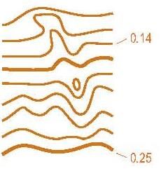
This International Specification for Orienteering Maps (ISOM2017) has been compiled
and edited by the IOF Map Commission (March/2017).

This work is licensed under a Creative Commons Attribution-NoDerivatives 4.0 International Public
License. For additional license information https://creativecommons.org/licenses/by-nd/4.0/
For the full license text https://creativecommons.org/licenses/by-nd/4.0/legalcode.txt

ISBN: 978-91-639-3394-3
INTERNATIONAL ORIENTEERING FEDERATION
Drottninggatan 47 3½ tr, SE-65225 KARLSTAD, SWEDEN
Website: www. orienteering.org
E-mail: iof@orienteering.org

                                                                                                    2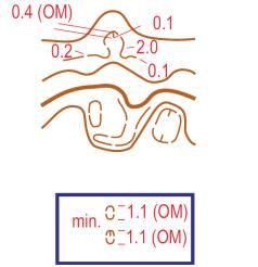
1 INTRODUCTION
Orienteering is a world-wide sport. A common approach to the interpretation and drawing of
orienteering maps is essential for fair competition and for the future growth of the sport.
These specifications should be read in conjunction with the Competition Rules for IOF
Mountain Bike Orienteering Events. For IOF events, deviations are permissible only with the
sanction of the IOF Map Commission (IOF MC). For other events such sanction must be given
by the national federation.
It is the aim of the International Specification for Orienteering Maps (ISOM) to provide a map
specification which can accommodate the many different types of terrain around the world and
the many ways of doing orienteering. Map specifications for mountain bike orienteering are
based on the specifications for foot orienteering maps. However, in order to meet the specific
requirements put on the map by the nature of mountain bike orienteering, a complete and
separate set of specifications is described in this set of rules.

2 GENERAL REQUIREMENTS
2.1 Orienteering and the map
Mountain bike orienteering (MTBO) is a sport in which the competitor completes a course of
control points in the shortest possible time, aided only by map, compass and bike. As in all
forms of sport, it is necessary to ensure that the conditions of competition are the same for all
competitors. The more accurate the map, the better this can be done, and the greater the
opportunity for the course planner to set a good and fair course.
From the competitors' point of view, an accurate and legible map is a reliable guide for choice
of route, and it enables them to navigate along a route chosen to suit their navigational skill and
physical ability. However, skill in route choice loses all meaning if the map is not a true picture
of the ground — if it is inaccurate, out-of-date or of poor legibility.
The path and track network shows where the going and navigation is easiest. A detailed
classification of the degrees of hindrance or good going helps the competitor to make the right
decisions. Orienteering is, first of all, to navigate by map reading. An accurate map is, there-
fore, necessary for a good and effective route choice. In the ideal case no competitor should
gain an advantage or suffer a disadvantage because of faults on the map.
The aim of the course planner is a course where the deciding factor in the results will be
navigational skill. This can be achieved only if the map is sufficiently accurate, complete, and
reliable, and also clear and legible under competition conditions. The better the map the
course planner has, the greater the chance he has of setting good, fair courses, whether for
the elite or for the novice.
For the mapper, the task is knowing which features to map and how to represent them. A
continuing involvement in the sport is important for a basic understanding of the requirements
for the orienteering map: its content, the need for accuracy, the level of detail and above all the
need for legibility.

2.2 Content
Mountain bike orienteering is a sport in which the competitor uses the map to navigate a track
and path network in order to visit a number of control points.

                                                                                                 3
Mountain bike orienteering takes place on the track and path network and involves as a basic
element complex route choice problems, including the estimating of height differences. It is
obvious that the map must concentrate on clearly depicting these features. The map must also
be legible when cycling at high speed. This means that the map should omit a large number of
details in "free" terrain in order to exaggerate the track and path network and to simplify the
presentation of the shape of the ground. Only details that impact a) route choice and b) nav-
igation and positioning, need be shown on the map.
A mountain bike orienteering map is a detailed topographic map. The map must contain the
features which are obvious on the ground to a competitor at speed. It must show every feature
which could influence map reading or route choice.
The map must show the features which are obvious on the ground and which are of value from
the point of view of map reading. When surveying, an attempt must be made to maintain the
clarity and legibility of the map, i. e. the minimum dimensions designed for normal sight must
not be forgotten when choosing the degree of generalization.
The map must contain magnetic north lines and may additionally contain some place names
and peripheral text to help the competitor to orientate the map to north. This text should be
written from west to east. Text within the map should be placed to avoid obscuring important
features, and the style of lettering should be simple.
The sides of the map should be parallel to the magnetic north lines. Arrowheads may be used
to show magnetic north.
2.3 Accuracy
The general rule should be that competitors shall not perceive any inaccuracy in the map.
The accuracy of the map as a whole depends upon the accuracy of measurement (posi-
tion, height and shape) and the accuracy of drawing. Mappers need to pay especially
attention to symbol 510 and 511 to show exact junction point and angle. All distinct junc-
tions and crossings must be drawn solid in order to clarify the exact position and angle of
the junction or crossing. This is valid also for dotted tracks.
2.4 Generalization and legibility
Those features which are most essential for the competitor in competition must be selected
and presented on the orienteering map. To achieve this, in such a way that the map is legible
and easy to interpret, cartographic generalization must be employed. There are two phases of
generalization — selective generalization and graphic generalization.
Selective generalization is the decision as to which details and features should be presented
on the map. Two important considerations contribute to this decision — the importance of the
feature from the competitors' point of view and its influence on the legibility of the map. These
two considerations will sometimes be incompatible, but the demand for legibility must never be
relaxed in order to present an excess of small details and features on the map. Therefore, it will
be necessary at the survey stage to adopt minimum sizes for many types of detail. However,
consistency is one of the most important qualities of the orienteering map.
Graphic generalization can greatly affect the clarity of the map. Simplification, displacement
and exaggeration are used to this end.
43 MAP SPECIFICATION FOR MOUNTAIN BIKE ORI-
ENTEERING
3.1 Scale and symbol sizes
The scale for a mountain bike orienteering map is often smaller than that for a foot orienteering
map. Organisers are encouraged to use maps drawn specifically for mountain bike orient-
eering at an appropriate scale, which will normally be 1:10 000, 1:15 000 or 1:20 000. 1:5000
and 1:7500 scales are suitable for sprint.
The official map scales in official IOF mountain bike orienteering events:
1 : 20 000 for long distance events
1 : 15 000 for relay, middle and long distance events
1 : 10 000 for relay, sprint and middle distance events
1 : 7 500 a 1 : 5 000 for sprint and sprint relay events
For practical reasons, a map should not be larger than is necessary for the orienteering
competition. Maps larger than A3 should be avoided. Sprint maps shall not exceed
300x300mm.
Course marking symbols in section 4.8 (symbols: 701-706 and 840) shall not be enlarged from
1:15 000 size in other scales. Other overprint symbols shall be enlarged by 1.5x.
The size of symbols in different scales:
Scale Symbols
1 : 20 000 As specified in this publication
1 : 15 000 As specified in this publication
1 : 10 000 Enlargement (1,5×) from 1 : 15 000 map
1 : 7 500 Enlargement (1,5×) from 1 : 15 000 map (same as 1 : 10 000)
1 : 5 000 Enlargement (1,5×) from 1 : 15 000 map (same as 1 : 10 000)
No deviations from the given dimensions within these specifications are permitted. It is how-
ever accepted that due to limitations in printing technology the final map symbol dimensions
may vary up to +/-5%.
Dimensions in this book are given at the printed scale of 1:15 000 except for symbols in the
sprint section 4.9 that are given at printed scale of 1:10 000 (this means no dimension change
is required on any 1:10000, 1:7500 or 1:5000 sprint map).
All line widths and symbol dimensions must be kept strictly to their specified value. Certain
minimum dimensions must also be observed. These are based on both printing technology
and the need for legibility.
MINIMUM DIMENSIONS
• Shortest dashed and dotted path/track symbol: at least two dots/dashes
o Very short sections of paths can be drawn with only 1 dash (symbol 831 or
832) for clarity in junctions etc.
• Minimum gap between parallel paths that do not connect: 1mm
• Minimum gap between paths ends/junction that do not connect: 5mm
• Minimum gap between buildings and other passable routes shall be 1mm.
• Smallest area of colour
5o Blue, green, grey or yellow full colour: 1 mm2
o Orange full colour and black dot screen: 2 mm2
o Blue, brown, green or yellow dot screen: 2 mm2
All features smaller than the dimensions above must be either exaggerated or omitted,
depending on whether or not they are of significance to the competitor. When a feature is
enlarged, neighbouring features must be displaced so that the correct relative positions
are maintained.
3.1.2 Scale and symbol size for Masters
Young and ageing eyes have different needs to elite athletes. In order to accommodate
these needs, different scales may be used for different age groups. Older eyes (40+) have
a focal range 30-35cm with reading glasses. Unlike Foot Orienteering, the map in MTBO
cannot be moved closer to the face and into the focal range. Instead the athlete must move
their body to find the best reading position. It is therefore important that 40+ age classes
receive an adjusted map, with a scale and symbol size better suited to their needs. It is
recommended Master maps use 1:10000 for middle and long distance events; with 1:7500
and 1:5000 being used for terrain with a dense track network and/or sprint events.
Event Format Elite Scale Master scale Master symbol size
Ultralong 1:20000 1:15000 1x
Long 1:15000 1:10000 1.5x
Middle 1:10000 1:10000/1:7500 1.5x
Sprint 1:7500/1:5000 1:7500/1:5000 1.5x
3.2 Contour interval
The contour interval for mountain bike orienteering maps is 5 m. In very hilly terrain an interval
of 10 m and in a flat terrain an interval of 2.5 m may be used. The aim is a clear representation
of the elevation.
Note: The same interval must be used all over the map!
3.3 Colours
The correct order of colours plays an important role in the legibility of a mountain bike ori-
enteering map. The order of colours of any mountain bike orienteering map is to be as follows:
• Upper purple: all purple symbols except control points (circles) and lines between them
• Black track and path symbols
• Lower purple: control points (circles) and lines between them
• Black 70 % symbols
• Brown
• Blue
• Green
• Yellow
3.4 Printing and reproduction
Even though new printing methods, like digital offset, colour copying etc., are developing
rapidly, traditional offset is still superior in quality when printing detailed maps. For IOF events
such as World Championships and World Cup this is the recommended method. However, if
6alternative methods produce maps with the same quality as traditional spot colour offset
printing, they will be accepted.
For smaller competitions, maps are likely to be reproduced in relatively small quantities and for
this the new and cheaper printing methods are well suited.
Desirable qualities for paper: easy to fold, easy to pierce with mapholder buttons, water-
proof, not easily torn or adhesive to self/other materials, should retain correct colour,
should not shrink or wrinkle when wet. Paper should not be less that 100gsm, and ideally
more than 110gsm.
3.5 Off-track travel
Due to different national laws and environmental issues, off-track travel may be restricted in
competitions. When off-track travel is not allowed this means the athlete is not allowed to pass
through the terrain, neither riding on the bike or on foot. The organisers can allow crossing the
terrain next to the bike, but this has to be well informed in bulletins etc.
So far, no good way of mapping off-track travel has been found. Due to this the organizer
always has to inform competitors (in bulletin, Team Officials meeting etc.) where riding is
allowed. Tracks symbols (4.1) are normally allowed to ride, unless they are marked on the map
accordingly to show travel is forbidden. All symbols showing riding is forbidden e.g.
Out-of-bounds area (709), or forbidden to cross e.g. forbidden route (711) will always be for-
bidden, regardless of whether off track travel is permitted or not.
If off-track travel is generally forbidden in the terrain, symbol 839 and 839.3 may be used to
show areas where this off-track riding is temporarily allowed.
If off-track travel is allowed in most of the terrain, but only smaller sections are not allowed
symbol 709 (out-of-bounds area) shall be used.
74 EXPLANATION OF SYMBOLS (MTBO)
Definitions of map features and specifications for the drawing of symbols are given in the
following sections. The dimensions of the symbols are the same in every scale.
Symbols are classified into 9 categories:
Track symbols (track black) Note: dimen- gap or infill
sions are < between two
Landforms (brown) lines
specified in
Rock and Boulders (black 70 %+grey for bare rock) mm at the real - line thickness
Water and Marsh (blue) distance from
map scale. =
centre to centre
Vegetation (green + yellow) All drawings are ø or length of line
Man-made features (black 70 %) in double diameter
scale for clarity symbol oriented
Technical symbols (black 70 % + blue) only. to north
Overprinting symbols (purple)
Additional sprint symbols
4.1 Track symbols
Track symbols are features that can be seen as “on-track” and are always allowed to ride if
no other overprint symbols show otherwise. These symbols are of main importance for
deciding route choices and for navigation. Symbols 501,502,503,503.1 shall be drawn to
scale in sprint maps. A track or path drawn on the map shall represent the rideable area. If
the track or path visibly appears much wider than the rideable area, symbol 401 open land,
403 rough open land or 839.2 open land permitted to ride (depending on national rules),
can be drawn in addition to clearly represent the appearance on the ground.
501 Motorway
A road with two carriageways. The width of the symbol should be drawn
to scale, but not smaller than the minimum width. The space between the
black lines must be filled with brown (50 %).
Colour: black and brown (50 %).
502 Major road
Tarmac/asphalt road wider than 5 m. The width of the symbol should be
drawn to scale, but not smaller than the minimum width. The space
between the black lines must be filled with brown (50 %). The symbol
may be used for tarmac roads.
Colour: black and brown (50 %).
503 Minor road
Tarmac/asphalt road 1.5 - 5mwide. The space between the black lines
must be filled with brown (50 %). The symbol may only be used for
tarmac roads.
Colour: black and brown (50 %).
Riding speed on tracks and paths is divided into four categories according to possible cycling
speed. The following ratios apply:
Fast riding 75–100 %
Medium riding 50–75 %
Slow riding 25–50 %
Difficult to ride max 25 %
8831 Track: fast riding
A track with stabilised surface, at least 1.5 m wide. Forest road or
well-maintained track with no obstacles. Speed 75-100 %.
Colour: black.
832 Path: fast riding
Well-maintained path narrower than 1.5 m wide. Smooth, clean path with
no erosion or obstacles. Speed 75-100 %.
Colour: black.
833 Track: medium riding
A track at least 1.5 m wide with some reduction in speed with the pos-
sibility of small obstacles such as stones, rocks, ruts, grass, sand or mud.
Speed 50-75 %.
Colour: black.
834 Path: medium riding
A path narrower than 1.5 m wide with some reduction in speed with the
possibility of small obstacles such as stones, rocks, ruts, grass, sand or
mud. Speed 50-75 %.
Colour: black.
835 Track: slow riding
A track at least 1.5mwide, with obstacles that require the riders to choose
their way to avoid obstacles such as stones, rocks, ruts, grass, sand or
mud. Possibility of rocky surfaces. Pedaling is more difficult, riding is
slowed. Skilled/fit riders will pass. Less skilled/fit riders may have to
dismount. Speed 25-50 %.
Colour: black.
836 Path: slow riding
A path narrower than 1.5 m wide, with sufficient obstacles to require the
riders to choose their way to avoid obstacles such as stones, rocks, ruts,
grass, sand or mud. Possibility of rocky surfaces. Pedaling is more dif-
ficult, riding is slowed. Skilled/fit riders will pass. Less skilled/fit riders
may have to dismount. Speed 25-50 %.
Colour: black.
837 Track: difficult to ride
A track at least 1.5 m wide, with difficult obstacles such as roots, deep
sand/mud, erosion or rocky steps. Very slow riding or impossible to ride.
Skilled/fit riders may be required to dismount. Speed max 25 %.
Colour: black
838 Path: difficult to ride
A path less than 1.5 m wide, with difficult obstacles such as roots, deep
sand/mud, erosion or rocky steps. Very slow riding or impossible riding.
Skilled/fit riders may be required to dismount. Speed max 25 %.
Colour: black.
833-838: In terrains with many singletracks, e.g. bike parks and mtb
trails, the gap between dashes may be reduced to 0.5mm on tracks
and paths with many tight corners, so as to clearly show the nature of
the trail: twisting trail with many corners and direction changes, pos-
sibly occurring in a small area.
510 Visible path junction
When a junction or intersection of paths or tracks is visible, the dashes of
the symbols are joined at the junction.
Colour: black.
9511 Indistinct junction
When a junction or intersection of paths or tracks is not clear, the dashes
of the symbols are not joined.
Colour: black.
839 Open land, permitted to ride
An area of grassland that is permitted to ride, when off-track riding is
otherwise forbidden. The permitted area should have obvious borders
or be marked in the terrain.
Colour: Orange (60% magenta, 100% yellow)
839-3 Forested area, permitted to ride
An area of terrain with a dense track network or little ground vegeta-
tion where riding everywhere is allowed. Predominant track/paths
going through this area shall be shown to aid navigation. The per-
mitted area should have obvious borders or be marked in the terrain.
Colour: Black
Dimensions: Dots 0.35mm, distance 0.9 mm, angle 45degree
211 Open sandy ground
An area of soft sandy or soft gravelled ground where cycling is difficult
or impossible, but it is permitted to ride.
Colour: black and yellow 50% (see 403).
Dimension: Diameter 0.2mm, distance 0.6mm.
841 One way compulsory
For use on tracks and paths where it is only allowed to ride in one
direction, for example on mountain bike singletracks. The frequency
of chevron arrows depends on the overall length of track/path in
question. At minimum, there should be one at the start, after each
adjoining junction, and at the end.
Colour: Upper purple
Dimension: 0.35mm line width, 2.5mm height, 45 degrees
529 Paved and gravel area
A paved/gravel area is an area with a firm level surface such as as-
phalt, tiles, hard gravel, concrete or the like. It should be bordered (or
framed) by the symbol step or edge of paved and gravel areas
(529.1). Distinct differences within the paved area can be represented
with the symbol step or edge of paved area (529.1), if they serve
navigation.
Colour: brown 50%
529.1 - Step or edge of paved and gravel areas
A step or an edge of a paved area.
Colour: black.
Dimension: 0.14mm
529.3 – Stairs
A flight of stairs in the terrain. Use symbol 843, dangerous object, at
the top of the stairs if they are especially dangerous
Colour: black, with 30% brown fill
Dimension: Width 0.6mm, line width 0.14mm, distance between stairs
0.5mm
104.2 Landforms
The shape of land is shown by means of contours. This is complemented in black 70 % by the
symbols for rock and cliffs. Orienteering terrain is normally best represented with a 5mcontour
interval.
In order to maintain legibility of the map with scales down to 1: 20 000, when cycling at high
speed the contour lines may be more generalised in comparison to foot orienteering maps.
The relative height difference between neighbouring features must be represented on the map
as accurately as possible. Absolute height accuracy is of less importance. It is permissible to
alter the height of a contour slightly if this will improve the representation of a feature. This
deviation should not exceed 25 % of the contour interval and attention must be paid to
neighbouring features.
101 Contour
A line joining points of equal height. The standard vertical interval be-
tween contours is 5 metres. The smallest bend in a contour is 0.25 mm
from centre to centre of the lines.
Colour: brown.
102 Index contour
Every fifth contour shall be drawn with a thicker line. This is an aid to the
quick assessment of height difference and the overall shape of the terrain
surface. Where an index contour coincides with an area of much detail, it
may be shown with a normal contour line.
Colour: brown.
104 Slope line
Slope lines may be drawn on the lower side of a contour line, e.g. along
the line of a reentrant or in a depression. They are used only where it is
necessary to clarify the direction of slope.
Colour: brown
105 Contour value
Contour values may be included to aid assessment of large height dif-
ferences. They are inserted in the index contours in positions where other
detail is not obscured. The figures should be orientated so that the top of
the figure is on the higher side of the contour.
Colour: brown
106 Earth bank
A steep earth bank is an abrupt change in ground level which can be
clearly distinguished from its surroundings, e. g. gravel or sand pits, road
and railway cuttings or embankments. The tags should show the full ex-
tent of the slope, but may be omitted if two banks are close together.
Impassable banks should be drawn with symbol 201 (impassable cliff).
The line width of very high earth banks may be 0.25 mm.
Colour: brown.
107 Earth wall
Distinct earth wall. Minimum height 1 m.
Colour: brown.
11109 Erosion gully
An erosion gully or trench. Minimum depth 1.0 m.
Colour: brown.
4.3 Rock and boulders
Rock is a special category of land form. Rocks and boulders are not likely to affect route
choice, but where prominent they can serve as valuable features for navigation and position-
ing. The maps may show these features when they are visible to the competitor.
201 Impassable cliff
An impassable cliff, quarry or earth bank (see 106) is shown with a 0.35
mm line and downward tags showing its full extent from the top line to the
foot. For vertical rock faces the tags may be omitted if space is short, e. g.
narrow passages between cliffs (the passage should be drawn with a width
of at least 0.3 mm). The tags may extend over an area symbol repre-
senting detail immediately below the rock face. When a rock face drops
straight into water making it impossible to pass under the cliff along the
water’s edge, the bank line is omitted or the tags should clearly extend
over the bank line.
Colour: black 70% (60 lines/cm).
202 Rock pillars/cliffs
In the case of unusual features such as rock pillars, massive cliffs, or
gigantic boulders, the rocks shall be shown in plan shape without tags.
Colour: black 70% (60 lines/cm).
206 Boulder
A distinct boulder (minimum height 1 m). Every boulder marked on the
map should be immediately identifiable on the ground. This symbol 206 is
the only symbol for boulders.
Colour: black 70% (60 lines/cm).
210 Boulder fields / Stony ground
A stony or rocky ground which affects going should be shown on the map.
The dots should be randomly distributed with density according to the
amount of rock. A minimum of three dots should be used.
Colour: black 70% (60 lines/cm).
212 Bare rock
A ridable area of rock without earth or vegetation is shown as bare rock. An
area of rock covered with grass, moss or other low vegetation is shown as
open land (401/402).
Colour: black 30% (60 lines/cm) or grey.
4.4 Water and marsh
Besides navigation and positioning, this group is important to the competitor as it facilitates the
interpretation of height in maps with complex contouring. In dry areas the features listed in this
section may only contain water in some seasons.
301 Lake
Large areas of water are shown with dot screen (50 %). Small areas of
water should be shown with full colour. The colour of the bank line is blue
100 %.
12Colour: blue.
304 Uncrossable river
An uncrossable river or canal is drawn with blue bank lines.
Colour: blue.
305 Crossable watercourse
A crossable watercourse, minimum 2 m wide. The width of watercourses
over 5 m wide should be shown to scale.
Colour: blue.
306 Crossable small watercourse
A crossable watercourse (including a major drainage ditch) less than 2 m
wide. For better legibility a ditch in a marsh should be drawn as a cross-
able watercourse (305).
Colour: blue
307 Minor water channel
A natural or man-made minor water channel which may contain water only
intermittently.
Colour: blue.
309 Uncrossable marsh
A marsh which is uncrossable or dangerous for the competitor. A blue line
surrounds the symbol.
Colour: blue.
310 Marsh
A crossable marsh, usually with a distinct edge. The symbol should be
combined with vegetation symbols to show runnability and openness.
Where a small marsh area should be combined with either 403 or 404 it is
permitted to use 401 / 402 to improve legibility.
Colour: blue.
314 Special water feature
A special small water feature. The definition of the symbol must always be
given in the map legend.
Colour: blue.
4.5 Vegetation
In terrain where off-track travel is allowed the representation of vegetation both has a
navigational purpose and for deciding route choices. If off-track travel is forbidden the
representation of vegetation is of importance to the competitor only for navigational pur-
poses, not for route choices. This is important to have in mind when surveying the map.
For example, if the forest is dense on one side of the path and sparse on the other, this
presents navigation and positioning information.
It should also be noted that the foot orienteering symbols 414 and 416 (cultivation
boundaries) should be omitted since they may cause confusion with some of the symbols
used for tracks and paths.
COLOUR
The basic principle is as follows:
white represents forest with good visibility. If off track travel is permitted, white forest
should have a speed of equivalent to that of symbols 835/836.
yellow represents open areas divided into several categories after its rideability and
vegetation. For open land the riding speed should be equivalent to symbols 833/834.
green represents the density of the forest and is clearly difficult to pass, either on or off the
bike.
13401 Open land with good rideability
Open parkland, meadows, grassland, etc. without trees. Rideability
equivalent to symbols 833/834. If yellow coloured areas become
dominant, a screen (75 %) instead of full yellow may be used. Colour:
yellow.
402 Open land with scattered trees. Good ridebility
Parkland with scattered trees that allows a riding speed equivalent to
symbols 833/834. Individual trees may only be shown if they are dis-
tinct from their surroundings (418/419) and when shortcutting is per-
mitted, to provide a navigation feature or control point. This symbol
should be used to generalise the terrain.
Colour: yellow (20 lines/cm).
403 Rough open land with reduced rideability
Heath, moorland, felled areas, newly planted areas (trees lower than
ca. 1 m) or other generally open land with rough ground vegetation,
heather or tall grass. Rideability equivalent to symbols 835/836 and
837/838.
Colour: yellow 50%(60 lines/cm).
404 Rough open land with scattered trees. Very reduced rideability
Scattered trees in rough open land, typically long grass areas where
riding speed is equivalent to symbols 835/836 and 837/838. It is not
recommended to add individual trees, unless they are exceptionally
distinct from surroundings (418/419) and provide a navigation feature
or control point, when shortcutting is permitted.
Colour: yellow 50%, white
405 Forest: good visibility, normal track rideability
Typically open forest for the terrain, where travel across allows the
equivalent speed of symbols 835/836 by bike or running with bike.
Colour: white.
406 Forest: reduced visibility, difficult/impassable rideability
Dense forest with low visibility. If shortcutting is permitted, the speed
to bike or run through should be difficult or impossible forcing the
competitor to dismount.
Colour: green 30% (60 lines/cm).
407.1 Undergrowth: good visibility, reduced off-track rideability
An area of dense undergrowth but otherwise good visibility (brambles,
heather, low bushes, cut branches etc), which reduces off-track
rideability to difficult or impossible requiring the competitor to dis-
mount. Symbol should only be used when off-track riding is allowed.
Colour: green 50%
Dimension: diameter 0.55mm, distance 0.7mm
412 Orchard
Land planted with fruit trees or bushes. The dot lines may be orientated to
show the direction of planting. If yellow coloured areas become dominant,
a screen (75 %) instead of full yellow may be used.
Colour: yellow and green 25% (12.5 lines/cm).
14413 Vineyard
The green lines may be orientated to show the direction of planting. If
yellow coloured areas become dominant, a screen (75 %) instead of full
yellow may be used.
Colour: yellow and green.
418, 419 Special vegetation features
418 – vegetation feature - undefined
419 - Large distinct tree that is immediately identifiable and can be
used for control points.
Colour: green.
509.1 Narrow ride, impossible riding
Non-rideable, overgrown, narrow forest rides shall be represented.
They may be represented to scale.
Colour: yellow (50%). Dimension 0.6mm minimum width
509.2 Narrow ride, medium riding
Rides and extraction lanes with a surface that allows a riding speed
equivalent to symbols 833/834. They may be represented to scale.
Colour: yellow (100%). Dimension 0.6mm minimum width
527 Settlement (Forbidden to enter)
Houses and gardens and other built up areas. Buildings and other
significant features within a settlement must be shown. Road en-
trances shall be represented when all access is forbidden providing
they aid navigation. Viable routes with forbidden access shall be re-
moved from the area except for the entrance and exit. A permitted
route shall be represented by a continuous road or track symbol
throughout the area.
Colour: yellow 100%, green 50%
4.6 Man-made features
The track and path network provides information fundamental to the competitor. Other
man-made features are also important both for map reading and as control points.
515 Railway (forbidden)
A railway or other kind of railed track.
Colour: black 70% (60 lines/cm).
516 Power line, cableway or ski lift
The bars indicate the exact location of the pylons.
Colour: black 70% (60 lines/cm).
517 Major power line
Major power lines should be drawn with a double line. The gap between
the lines may indicate the extent of the power line.
Colour: black 70% (60 lines/cm).
518 Tunnel
Away under roads, railways, etc., which may be used by the competitor.
This symbol is used whether or not the tunnel has a track leading to it.
Colour: black 70% (60 lines/cm).
15519 Passable stone wall
A stone wall less than 1.0m, that is allowed and possible to cross.
Colour: 70% grey
Dimension: 0.21mm baseline, 0.75mm circle diameter, distance be-
tween circles 3.0mm
521 Uncrossable stone wall (Forbidden to cross)
A stone wall of any height that is forbidden to cross. A high stone wall
>1.0m. shall always be marked as forbidden since it poses a dan-
ger/significant time loss to cross for the athlete.
Colour: 70% grey
Dimension: 0.35mm baseline, 0.75mm circle diameter, distance be-
tween circes 0.84mm, distance between circle groups 3.0mm
It is forbidden to cross an impassable stone wall.
522 Crossable fence
A fence less than 1.0m high that is allowed and possible to cross.
Colour: 70% grey
Dimension: baseline 0.21mm, tag length 0.7mm, tag thickness
0.17mm, distance between tags 3.0mm
524 Uncrossable fence (Forbidden to cross)
A fence of any height that is forbidden to cross. A high fence >1.0m
should be marked as forbidden since it poses a danger/significant
time loss to cross for the athlete.
Colour: 70% grey
Dimension: baseline 0.35mm, tag length 0.7mm, tag thickness
0.17mm, distance between tags 0.72, distance between tag groups
3.0mm
It is forbidden to cross an impassable fence or railing!
525 Crossing point
All ways through or over high fences or walls must be indicated. The
symbol may also be used for a gate through or stile over a stone wall
(521) or a fence (524) or a pipeline (534).
Colour: black 70% (60 lines/cm).
533 Pipeline
A pipeline that is easy for athletes to cross over (or under), which
doesn’t require significant time loss.
Dimension: As per ISMTBOM but with single chevron and line widths
of 0.14mm.
534 Uncrossable Pipeline (Forbidden to cross)
A pipeline of any height that is forbidden to cross.
Dimension: As per 2010 ISMTBOM.
526 Building
A building is shown with its ground plan as so far as the scale permits.
There should be a 0.1mm 100% black bounding line around buildings
to improve clarity and legibility from other colour tones.
Colour: 70% black, 100%black bounding line
16531 Firing range
A firing range is shown with a special symbol to indicate the need for
caution. Associated buildings are individually marked.
Colour: black 70% (60 lines/cm).
532 Grave
A distinct grave marked by a stone or shrine. Location is at the centre of
gravity of the symbol, which is orientated to north. A cemetery is shown
by using grave symbols as space permits.
Colour: black 70% (60 lines/cm).
535 High tower
A high tower or large pylon, standing above the level of the surrounding
forest. Location is at the centre of gravity of the symbol.
Colour: black 70% (60 lines/cm).
536 Small tower
An obvious shooting platform or seat, or small tower. Location is at the
centre of gravity of the symbol.
Colour: black 70% (60 lines/cm).
538 Fodder rack
A fodder rack which is free standing or built on to a tree. Location is at the
centre of gravity of the symbol. For land access reasons these may be
omitted.
Colour: 70% (60 lines/cm).
539, 540 Special man-made features
Special man-made features are shown with these symbols. The defini-
tion of the symbols must be given in each case in the map legend.
Colour: 70% (60 lines/cm).
4.7 Technical symbols
601 Magnetic north line
Magnetic north lines are lines placed on the map pointing to magnetic
north. At the scale of 1:5000,1: 7500 and 1:10 000 the spacing of north
lines on the map should be 30 mm, while at the scale of 1:15 000 and
1:20 000 the spacing on the map should be 20 mm. North lines may be
broken where they obscure small features such as boulders, cliffs,
stream junctions, and path ends.
Colour: blue.
602 Registration marks
At least three registration marks must be placed within the frame of a
map in a nonsymmetrical position. In addition, a colour check should also
be possible.
Colour: all printed colours.
603 Spot height
Spot heights are used for the rough assessment of height differences.
The height is given to the nearest metre. The figures are orientated to the
north. Water levels are given without the dot.
Colour: black.
174.8 Overprinting symbols
701 Start
The start or map issue point (if not at the start) is shown by an equilateral
triangle which points in the direction of the first control. The centre of the
triangle shows the precise position of the start point.
Colour: upper purple.
702 Control point
The control points are shown with circles. The centre of the circle shows
the precise position of the feature. Sections of circles should be omitted
to leave important detail showing.
Colour: lower purple.
Diameter of control circles is the same in all scales.
840 Control point with focus point (in MTBO maps)
The focus point (i.e. the point in the centre of a control circle) can be used
when it is necessary to clarify the exact position of a control for instance
in a dense track network. The focus point shall be used in case of ne-
cessity when the exact position of a control is not clear. A focus point
helps to specify the exact track where a control is situated.
Colour: lower purple (circle), upper purple (focus point).
7xx Control code
Control code shall use Arial with a height of 4mm. Both control
number and code shall be bordered with a small white borderline to
improve legibility if necessary.
703 Control number
The number of the control is placed close to the control point circle in
such a way that it does not obscure important detail. The numbers are
orientated to north.
Colour: upper purple.
Font:Arial, height of letters 4 mm.
704 Line
Where controls are to be visited in order, the start, control points, and
finish are joined together by straight lines. Sections of lines should be
omitted to leave important detail showing.
Colour: lower purple.
705 Marked route
A marked route is shown on the map with a dashed line. If the symbol is
used instead of symbol 704 before or after a control, it represents an
obligatory route for the competitors. The symbol can also be used in
areas where off-track riding is forbidden to represent allowed routes that
are marked in the terrain.
Colour: upper purple
706 Finish
The finish is shown by two concentric circles.
Colour: upper purple
18707 Uncrossable boundary (Forbidden to cross)
A boundary that is not permitted to cross. Due to similarities between
707 and 843, this symbol should not be used as a single, stand alone
straight line across a track or paved area or along the length of an
uncrossable feature. If a section of track shall not be used by com-
petitors, symbol 844 or 711 should be used.
Colour: upper purple.
Dimension: width 0.8mm
It is forbidden to cross an out-of-bounds area!
708 Crossing point
A crossing point through or over a wall or fence, or across a road or
railway, or through a tunnel or an out-of-bounds area is drawn on the
map with two lines curving outwards.
Colour: upper purple.
709 Out of bounds area (Forbidden to cross)
An out-of-bounds area is shown with vertical stripes. A bounding line
should be drawn if the area is marked with tapes in the terrain. If
off-track riding is forbidden or there are other natural boundaries only
track symbols leading into the forbidden area need to be marked
when the bounding line is shown. The areas that may be dangerous to
competitors shall be presented by this symbol.
Colour: purple.
Dimension: line thickness 0.25mm, line space 0.6mm, bounding line
0.25mm.
It is forbidden to cross an out-of-bounds area!
711 Forbidden route
A route which is out-of-bounds and forbidden to cross is shown with a
zigzag. The zigzag line should be as continuous as possible. If there is a
crossing point over the forbidden route, it shall be presented like a gate
by two perpendicular lines over the forbidden route. Also a longer
crossing section shall be presented clearly on the map by using the
perpendicular lines at the end of the zigzag lines.
Colour: upper purple.
712 First aid post
The location of a first aid post.
Colour: upper purple.
713 Refreshment point
The location of a refreshment point which is not at a control.
Colour: upper purple.
714 Temporary construction, closed area or outside restaurant
(Forbidden to cross)
Obvious temporary constructions like platforms for spectators and
speaker, closed area for spectators, outside restaurant areas, etc.
shall be represented in plan shape. Must be distinctly visible on the
ground
Colour: purple 50%.
It is forbidden to enter a temporary construction or closed area!
19843 Dangerous object across tracks or paths, stairs
These barriers must be highly visible on the map and should be over-
printed in purple. The symbol should be used for all obstacles that are
difficult to cross. For uncrossable barrier, symbol 844 shall be used. This
symbol can be used for stairs. There is no particular stair symbol.
Colour: upper purple.
844 Uncrossable barrier / forbidden to cross
This symbol can be used for all spots that are forbidden or impossible to
pass, e.g. uncrossable barriers; fences or walls that are forbidden or
impossible to cross; short sections of roads, tracks or paths that are
forbidden to use (for longer sections, symbol 711 shall be used). In spots
where two tracks or paths almost meet, but the situation is not obvious on
the map, this symbol can be used to indicate that crossing is forbidden.
Colour: upper purple.
4.9 Additional sprint symbols
For maps to be used in for sprint distance the following symbols can also be used. Di-
mensions in this section are given at the printed scale of 1:5 000, 1:7 500 and 1:10 000.
4.9.1 Track symbols
529,2 Paved area - urban
On sprint maps (urban areas) paved roads (501, 502 and 503) and
paved areas shall be drawn to scale with 30% brown. Gravel areas
(urban) shall be drawn with 50% brown (529.0). For forest sprint
races, or maps with sections of forest, 50% brown may be used in the
non-urban areas for all asphalt surfaces.
A paved area is an area with a firm level surface such as asphalt, tiles,
concrete or the like. It should be bordered (or framed) by the symbol
step or edge of paved and gravel areas (529.1). Distinct differences
within the paved area can be represented with the symbol step or
edge of paved area (529.1), if they serve navigation.
501 – Motorway shall always be drawn to scale
502 – Major road shall be drawn to scale, but no smaller than mini-
mum width: 1.2mm (on maps with scale larger than 1:10000)
503 – Minor road shall be drawn to scale, but no smaller than mini-
mum width: 0.9mm (on maps with scale larger than 1:10000)
Sidewalk/pavement – Shall be drawn to scale, but not smaller than
minimum width: 0.6mm (on maps with scale larger than 1:10000)
Please note: It is advisable to use the paved area symbol in urban
areas for bike paths. In forested areas, bike paths may be drawn
using symbols 831/832.
Colour: brown 30% (paved area) / 50% (gravel)
204.9.2 Landforms
103 Form line
An intermediate contour line to be used to give more information
about the shape of the ground, where it will aid navigation. Only one
form line may be used between neighbouring contours.
Colour: brown.
110 Small erosion gully
A small erosion gully or trench which is a significant aid to navigation,
where riders should not need to dismount. Minimum depth is 0.5 m.
Colour: brown.
112 Small knoll
A small obvious mound or rocky knoll which cannot be drawn to scale
with a contour (101) or index contour (102). The height of the knoll
should be a minimum of 1 m from the surrounding ground. Small
knolls shall only be drawn if they aid navigation for the competitor.
Colour: brown.
Dimension: diameter 0.75mm
4.9.3 Rock and Boulders
No extra symbols needed.
4.9.4 Water and Marsh
No extra symbols needed.
4.9.5 Vegetation
420 Special vegetation feature
Small individual tree or bush, can be used to show trees that line
pavements/roads etc in paved areas. Recommended for use where
space is tight and the need for clarity takes precedence.
Colour: Green
Dimension: diameter 0.75mm
421 Forbidden vegetation (Forbidden to enter)
An area of vegetation which is forbidden to enter, due to forbidden
access (flowerbed etc) or because it may constitute a danger to the
competitor. Colour: green 100%
It is forbidden to enter forbidden vegetation!
421.1 Impassible hedge (Forbidden to cross)
Hedges are forbidden to cross. A hedge of any height, which is dis-
tinct in the terrain and provides an important navigational feature.
Colour: green,
Dimension: 0.5mm width
It is forbidden to cross an impassable hedge!
214.9.6 Man-made features
526.2 Canopy
A canopy is a building construction (with a roof), normally supported
by pillars, poles or walls, such as passages, gangways, courts, bus
stops, gas stations or garages. Drawn with 0.1mm black borderline
Small passable parts of buildings, which cannot easily be crossed by
competitors, shall not be represented on the map and shall be closed
during the competition.
Colour: black 30%
4.9.7 Technical symbols
No extra symbols needed.
4.9.8 Overprinting symbols
No extra symbols needed.
APPENDIX 1
This section contains symbol options for further testing. Dimensions are listed for 1:15000.
508.1 Indistinct track or path
An indistinct track or path that is possible to ride, but hard to identify
and/or follow in the terrain. The symbol can also be used on sections
of a track or path that is less distinct in the terrain.
Colour: Orange (60% magenta, 100% yellow) Line width: 0.6mm
508.2 Indistinct track or path
An indistinct track or path that is possible to ride, but hard to identify
and/or follow in the terrain. The symbol can also be used on sections
of a track or path that is less distinct in the terrain.
Colour: Black Line width: 0.55mm, Circle Diameter: 0.55mm, Gap
(two dots): 0.7mm, Gap (main length a): 2.00mm
22You can also read