Assessment of mangrove carrying capacity for ecotourism in Kemujan Island, Karimunjawa National Park, Indonesia
←
→
Page content transcription
If your browser does not render page correctly, please read the page content below
Assessment of mangrove carrying capacity for
ecotourism in Kemujan Island, Karimunjawa
National Park, Indonesia
1
    Adi Winata, 1Ernik Yuliana, 1Yuni T. Hewindati, 2Wibowo A. Djatmiko
     1
     Faculty of Science and Technology, Universitas Terbuka Jl. Cabe Raya Pondok Cabe,
    Pamulang, Tangerang Selatan, Banten, Indonesia; 2 The Indonesian Tropical Institute,
         Situgede, Bogor, West Java, Indonesia. Corresponding author: E. Yuliana,
                       erniky157@gmail.com; ernik@ecampus.ut.ac.id

         Abstract. Mangrove ecosystem is one of valuable coastal ecological units with unique characteristics,
         mainly because it is located in the transition region between land and sea, and strongly influenced by the
         dynamics of the tides. Apart from that, mangrove ecosystem has a lot of potential for ecotourism. The
         Karimunjawa National Park (KNP) is one of protected areas in Indonesia with mangrove ecosystem that
         is developed for the aforementioned purpose, known as the Kemujan Trekking Mangrove (TMK). The
         present study is carried out to assess the suitability and carrying capacity of mangrove ecosystem in the
         TMK area for ecotourism activities. Primary data for this study consist of the number of flora and fauna
         species, tree density, and inundation levels in the ecosystem, which are collected by means of grid-cell
         method. Data from the field were processed through image analysis, vegetation analysis, land suitability
         analysis, and physical carrying capacity assessment of the site for ecotourism purpose. Analysis of
         mangrove vegetation structure, revealed that Lumnitzera racemosa has the highest Importance Value
         Index (IVI) of 167.61%, followed by Ceriops tagal (62.87%) and Rhizophora stylosa (25.51%). There are
         approximately 42 animal species recorded in Tracking Mangrove Kemujan (TMK) area, including 19
         species of birds. Other taxa recorded were mammals, reptiles, fish, crustaceans and mollusks. Following
         ecotourism suitability assessment, the TMK is categorized as "very suitable" with the tourism suitability
         index (TSI) of 81.9%; especially due to its mangrove tree density, species richness of flora and fauna,
         and the variety of animal taxa. The carrying capacity of TMK for tracking activities was 104 people day -1,
         while for birdwatching activities was 116 people day-1.
         Key Words: flora, fauna, biodiversity, tourism suitability index, ecosystem.

Introduction. Mangrove ecosystem is one of the valuable coastal ecological units with
unique characteristics. Mangroves are widely recognized for their capacity to contain
drifted mud and many kinds of debris washed away by sea currents, including organic
waste and other discarded materials from the land. Because of its highly fertile
environment, mangrove habitat is a haven for numerous species of biota. They are
vulnerable, extreme, and highly dynamic since they are generally located in the zones
where the sea meets the land, saltwater meets fresh water, and ocean ebbs and flows
are the major contributor of the dynamic force. With these unique characteristics, no
wonder that most of mangrove biomes are also distinctive in nature, particularly the
aquatic species. Unlike the mangrove aquatic animals, many of the terrestrial ones can
be found straddling the mangrove and its adjacent ecosystems.
       With their position in intertidal zones, one important role that mangrove plays as
an ecological unit is a sustaining system for coastal ecosystems. For land environments,
mangrove serves as a protector from potential threat of tsunami, erosion and abrasion,
seawater intrusion, and various other threats that may harm terrestrial biodiversity. For
water environments, mangrove play crucial roles as a sustainable habitat, foraging
destination, spawning zone, as well as a home for aquatic animals to feed and care for
their young (Tuwo 2011).
       Observed from another perspective, mangrove ecosystem, particularly mangrove

AES Bioflux, 2020, Volume 12, Issue 1.
http://www.aes.bioflux.com.ro
                                                         83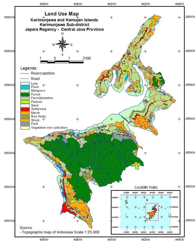
forest, hold a lot of potential to be a site designated for ecotourism activities. Ecotourism
is a nature-based tourism whose management combines educational aspect and
interpretational aspect orientated towards natural and cultural elements as well as
ecological sustainability (Tuwo 2011). Mangrove ecotourism can be a promising economic
resource for both its management and the local community, and at the same time, it can
be aimed at mangrove conservation (Wiharyanto 2007) through education and promotion
of environmental awareness.
        Karimunjawa National Park (KNP) is one of marine national parks in Indonesia that
are mainly intended to protect marine ecosystems especially the coral reef. KNP is where a
400-hectares mangrove ecosystem can be found extending across several islets (KNPA
2018). This mangrove’s distinctive characteristic is that it is lack of freshwater sources such
as streams or rivers. The largest area of mangrove forest lies across Kemujan Island and
Karimunjawa Island, which are the two biggest islands in the KNP region (KNPA 2015).
        The region’s establishment as a national park is a policy intended not only for the
protection and preservation of its biodiversity, but also for developmental purposes such
as education, research, cultivation, recreational and ecotourism activities, and the
provision of other nature-based services. It is for second category of purposes that KNP
Authority (KNPA) Office built a tourist track across the mangrove forest area, which has
been since known as Trekking Mangrove Kemujan (TMK) (KNPA 2015).
        The objective of the present research are to analyze the vegetation structure and the
diversity of mangrove flora and fauna in TMK area, to measure the suitability of the mangrove
ecosystem to be an ecotourism destination, and to assess its tourism carrying capacity.

Material and Method

Study area. The study area was the mangrove ecosystem at Kemujan Island (Figure 1),
Karimunjawa National Park, Karimunjawa Sub-district, Jepara Regency, Central Java Province.

Figure 1. Land use map of Kemujan Island, Karimunjawa Sub-district (Rahadiati et al 2019).

AES Bioflux, 2020, Volume 12, Issue 1.
http://www.aes.bioflux.com.ro
                                              84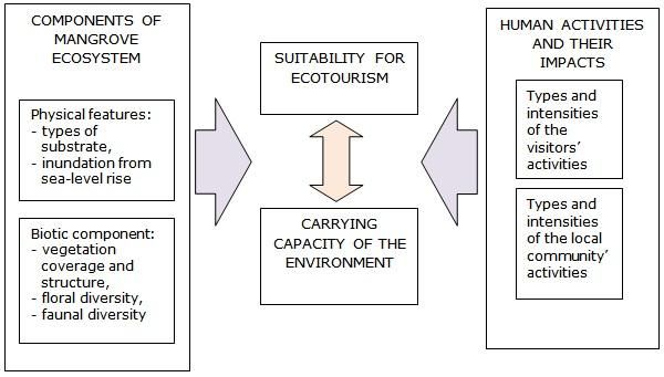
Research design. The interconnection between various components of the mangrove
ecosystem, the impacts of human activities on it, the ecosystem’s suitability for
ecotourism, and its carrying capacity can be delineated in Figure 2.

  Figure 2. A conceptual framework for conducting “A Carrying Capacity Assessment of
    Mangrove Ecotourism in Kemujan Island, Karimunjawa National Park, Indonesia”.

Land suitability assessment. The land suitability assessment of the mangrove forest
for ecotourism (Table 1) was conducted by means of the matrices proposed by Yulianda
(2007). The main attraction of mangrove ecotourism is its forest coverage. Therefore, it
is vital that the mangrove environment to be kept in its best condition so as to provide
the visitors with an enjoyable experience of exploring the ground under the shades of the
mangrove trees. Mangrove pathways in this area range from 50 to 200 meters, which
make them a reasonable distance for tourists to travel and see the transition zones
between the land and the ocean. What is more, the moderate tree density of the forest
allow more sunlight reaches the ground, and thus, more sights of scenery such as
different types of root system and mangrove fauna can be presented to the visitors,
giving them an adequate amount of natural light to take pictures. In addition, the
moderate density also prevents too much sunlight from making the temperature along
the pathways sweltering.
        The highly diverse species of vegetation and animals together with the wide range
of animal taxa to explore in the mangrove area are highly valuable as ecotourism
attractions. Moreover, the availability of important flora and fauna species, such as those
ones categorized as endemic (E), rare (R), threatened (T), or protected (P) according to
the prevailing laws, is especially worthy of special attention because those species
represent the undeniable reason for the significance of biodiversity conservation of the
mangrove ecosystem.
        The forest’s potential for ecotourism activities allow the management to make a
planning for a number of recreational activities they can possibly offer to the tourists
such as tracking (nature walk in the wood), nature photography, picnic, bird-watching or
wildlife viewing, eco-education, camping, and fishing. Different levels of inundation are
observed to record the possible zonal variations of the existing substrates and
vegetation. It is presumed that the more zonal variations occur in this area, the higher
the biodiversity can be expected from its ecosystem.

AES Bioflux, 2020, Volume 12, Issue 1.
http://www.aes.bioflux.com.ro
                                            85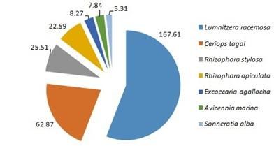
Table 1
Matrix of land suitability assessment of mangrove forest in KNPA for ecotourism purposes
                                      (Yulianda 2007)

                                                     Good,      Acceptable,   Substandard,    Poor,
           Parameters                    Weights
                                                    score=3      score=2        score=1      score=0
  The lengths of mangrove
                                           5       50-200 m     200-500 m       >500 m       20 trees     10 spp      6-10 spp       2-5 spp       1 sp
   Important plant species
                                           3        >3 spp       2-3 spp          1 sp          0
           (E/R/T/P)
   Faunal diversity (∑ spp)                5        >10 spp      6-10 spp       2-5 spp        1 sp
  Important animal species
                                           3        >3 spp       2-3 spp          1 sp          0
           (E/R/T/P)
     Animal taxa diversity
       (mammal, birds,
                                           4        >4 taxa        3-4             2            1
      herpetofauna, fish,
 crustaceans, molluscs etc.)
      Possible ecotourism
                                           4            >7         4-7            2-3           1
       activities to offer
                                                                                         Inundated
                                                   Inundated Inundated for Inundated for
                                                                                           for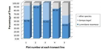
Table 2
Summary of parameters and research methodology adopted in this study
Techniques/
Parameters Methods
Instruments
The lengths of mangrove
Image analysis GIS
pathways
Tree density (trees 100 m-2) Vegetation analysis Grid cells
Floral diversity (∑ spp) Taking inventory of floral species
Grid cells,
Important plant species within and outside of the
exploration
(E/R/T/P) vegetation analysis plots.
Animal species diversity
(∑ spp)
Important animal species
Taking inventory of animal Grid cells,
(E/R/T/P)
species within and outside of the concentration counts,
Animal taxa diversity
vegetation analysis plots exploration
(mammals, birds,
herpetofauna, fish,
crustaceans, molluscs)
Possible ecotourism activities Reports, perceptions
Document analysis, interview
to offer of visitors’
Reports, information
Document analysis, interview,
Levels of inundation from rangers, field
observation
observation
GIS - geographic information system, E - endemic, R - rare, T - threatened, P - protected.
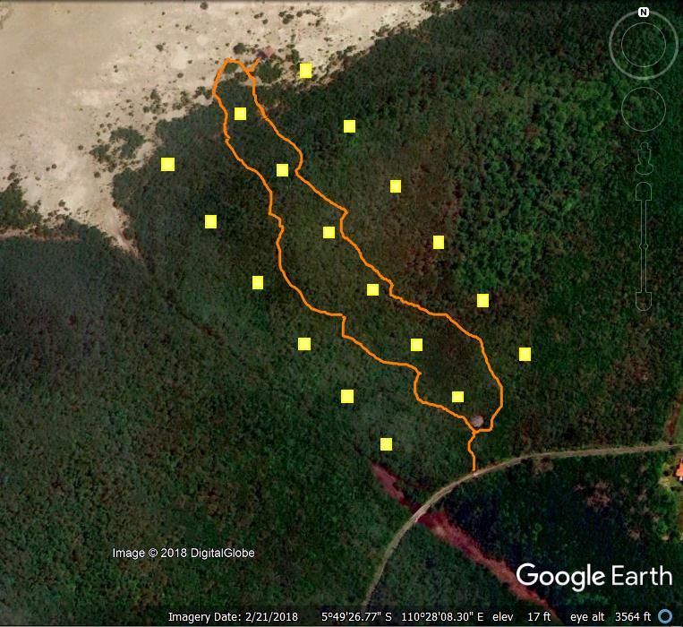
Method of vegetation analysis. To identify the species diversity and mangrove
vegetation structure in TMK area, three transects of vegetation were made to observe the
floral species in the area: two transect lines (Line 1 and Line 3) are to the right and left
of the tracking loop, and one line (Line 2) is in the middle between the tracking loop.
Each of transect line marks out six sampling plots, and each plot was 10 x 10 m in size.
The distance between the plots was 100 m, starting from the beginning of the loop
(Figure 3).
Figure 3. Sample plots (yellow square) lay-out around the Trekking Mangrove Kemujan
loop (orange line). According to Google Earth imagery (accessed 21/II/2018).
AES Bioflux, 2020, Volume 12, Issue 1.
http://www.aes.bioflux.com.ro
87Every tree in all of the sampling plots was examined to identify its species and its girth
measurement. Tree was defined as woody plants with ≥10 cm in diameter at breast
height (DBH) or ≥31.4 cm in girth. Other tree species which were not recorded from the
sampling plots, but observed outside the plots around TMK tracking loop, were recorded
also as supporting data: their species names and their qualitative estimation of
abundance.
Method of bird observation. Data on bird diversity were collected through
concentration counts method. For this purpose, 6 observation plots were laid out along
the tracking loop where the observation was performed 3 times from 7 to 10 in the
morning. The plots were circular with 20-meter radius. The intervals between
observations were 20 minutes. All bird species within the plots area during each of the
specified observation periods were recorded according to their scientific names and their
numbers. The method is based on the assumption that there won’t be any single bird
recorded twice throughout the entire observation.
Other methods of wildlife observation. Other taxa of animals in the region were
observed using accidental-opportunistic approach. These taxa consist of mammals,
reptiles, amphibians, fish, crustaceans, and molluscs. For these groups of animals, the
observation was not confined to some specific plots. Instead, it covered the whole area of
the mangrove forest which includes the tracking pathways, sampling plots for vegetation
and bird observations, and the areas adjacent to TMK that extended all the way to the
furthest mangrove mud tracks. These animals were observed and recorded qualitatively
according to their species names, the locations where they were found, and the
information of their abundance.
Data analysis. The data analysis included the following aspects:
Vegetation structure. The vegetation data were analyzed by means of these following
formulas.
a. Density of a species (De) (plants ha-1)
Number of individuals of a species
Size of sampling plot (ha)
b. Relative density (RDe)
Density of a species
× 100
Total density of all species
c. Frequency of a species (F)
Number of plots where species are found
Number of all sampling plots
d. Relative frequency (RF)
Frequency of a species
× 100
Frequency of all species
e. Dominance of a species (Do)
Total basal area of a species
Total area of sampling plots
AES Bioflux, 2020, Volume 12, Issue 1.
http://www.aes.bioflux.com.ro
88f. Relative dominance (RDo)
Dominance of a species
× 100
Total dominance of all species
g. Importance Value (IV)
IV = RDe + RF + RDo
Faunal diversity. The data of the mangrove fauna are presented here in tabulations of all
of the observed species according to their respective taxa (class, order, family, etc.). The
estimation of relative abundance or abundance proportion for bird species in the TMK was
performed using IPA (Indices Ponctuel d’Abondance) data analysis with a simple
statistical equation.
Important species of flora and fauna. Flora and fauna that are important for conservation
are plant and animal species which are categorized as endemic (E), rare (R), threatened
(T), or protected (P) species under Republic of Indonesia law. Conservation status here is
defined primarily by referring to the population vulnerability status according to the IUCN
Red List; with the possibility of cross referring to its status in the CITES Appendices.
Area suitability-for-ecotourism analysis. The area suitability index used for tourism
assessment or tourism suitability index (TSI) was applied in this research using the
following equation (Muflih et al 2015).
TSI = (Σ Vi / Vmax) × 100%
Where:
TSI : Tourism Suitability Index
Vi : The Value of parameter number i (weight × score)
Vmax : The maximum value a tourism category may achieve
and with weights and scores that have been presented in Table 1.
Afterwards, the TSI value (in percentage) was classified into one of these three
categories: “very suitable” for TSI >75%, “suitable” for 50%< TSI ≤75%, and “not
suitable” for TSI ≤50%.
Carrying capacity assessment of the ecotourism site. Tourism carrying capacity (TCC) of
a site is the maximum number of visitors that can be accommodated in a designated area
and period of time without causing disturbance to the area’s natural and social
environments. The measurement of PCC in this research was performed using the
equation from a research by Muflih et al (2015) with slight modifications.
TCC = Av × (Sa/Sv) × (Ta/Tv)
Where:
TCC : Tourism Carrying Capacity of an area
Av : The smallest unit of activity that visitors can do in the area (people)
Sa : The width or the size of the space that the area can provide for the
visitors’ activities (in meter or meter2)
Sv : The minimum spatial unit required for particular category of activity by
visitors (in meter or meter2)
Ta : The period time designated for particular tourism activity per day (hours)
Tv : Average time spent by visitors for each of the given tourism activities
(hours)
AES Bioflux, 2020, Volume 12, Issue 1.
http://www.aes.bioflux.com.ro
89TCC assessments which are based on the values of A v, Sa, Ta, and Tv made by a
number of researches about types of tourism activities that can be promoted in
mangrove forest are presented in Table 3 below.
Table 3
Carrying capacity assessments of certain tourism activities (Yulianda 2007; Douglass 1982)
Activities Av Sa Ta Tv
Tracking 1 50 m 8 2
Bird watching 1 67 m2 8 2
Picnic 1 16 m2 8 2
Camping 5 100 m2 24 24
Results and Discussion
General condition. The mangrove in Trekking Mangrove Kemujan (TMK) area
encompasses a community of vegetation which grows on dead coral reefs. Compared to
the mangroves that grow along the north coast of Java, mangrove trees in TMK are
generally short and low in species diversity. The crown heights of the trees range from 8
to 2 meters. There are 15 species of trees recorded around TMK, but only 7 of them were
observed in the sampling plots.
Furthermore, the observation of the substrates on which those vegetation species
grow has revealed that mangrove mud in TMK environment is mainly composed of
mangrove litters and white coral sand, mixed with a smaller amount of clay. An ecological
report on TNK informs that apart from the rainfall, TNK ecosystem is lack of freshwater
sources (Susanto et al 2012). The absence of rivers in this zone is presumably the main
reason why TMK area contains none or very little sediment input from soil erosion and
relatively less fertile substrates. It also explains the low diversity of mangrove species in
TMK and their short growth.
Vegetation species and structure. Based on the observation, Lumnitzera racemosa
(black mangrove) and Ceriops tagal (Indian mangrove) make up the predominate part of
mangrove vegetation in TMK. They mostly populate at the start (the edge of the forest)
and halfway through the tracking paths, but further along the paths, their population is
less and less abundant alongside a gradual shift of dominance from the two species
mentioned above to Rhizophora stylosa (spotted mangrove) whose population is found in
its highest density at the end of the tracking paths, which is on the shoreline. The
observed species of mangrove trees in the TMK area is provided in Table 4.
Table 4
Tree species recorded in and around the TMK Area
Scientific name Family English name Indonesian name Location
Aegiceras corniculatum Primulaceae River mangrove Duduk agung O
Avicennia marina Acanthaceae Grey mangrove Api-api I, O
Bruguiera cylindrica Rhizophoraceae - Burus O
Bruguiera gymnorhiza Rhizophoraceae Orange mangrove Putut, kendeka O
Ceriops tagal Rhizophoraceae Indian mangrove Tingi, tengar I, O
Excoecaria agallocha Euphorbiaceae Milky mangrove Buta-buta I, O
Heritiera littoralis Malvaceae Looking-glass mangrove Dungun kecil O
Hibiscus tiliaceus Malvaceae Beach hibiscus Waru O
Lumnitzera racemosa Combretaceae Black mangrove Teruntum putih I, O
Rhizophora apiculata Rhizophoraceae Tall-stilted mangrove Bakau minyak I, O
Rhizophora stylosa Rhizophoraceae Spotted mangrove Bakau kecil I, O
Rhizophora × lamarckii Rhizophoraceae - Bakau hibrida O
Scyphiphora hydrophylacea Rubiaceae - Duduk perempuan O
Sonneratia alba Lythraceae Mangrove apple Bogem, pidada I, O
Xylocarpus moluccensis Meliaceae - Nyirih batu O
I - found inside the sampling plots, O - found outside the sampling plots.
AES Bioflux, 2020, Volume 12, Issue 1.
http://www.aes.bioflux.com.ro
90As it is pointed out in Table 4, there were only seven species recorded as tree inside the
sampling plots. Other than these 7 species could not be included in the analysis due to a
couple conditions. Some plants were found outside the plots. Some other was within the
plot areas, but they were still in their early stages of their growth (e.g. seedlings or
saplings). From all of the 18 sampling plots, a list of measurements representing the
overall mangrove stand structure in TMK area could be developed. The list is presented in
Table 5.
Table 5
Mangrove Stand Structure in TMK area
∑
Scientific name De F TBA RDe RF RDo IV
trees
Lumnitzera racemosa 114 633.3 0.78 19,004.7 65.5 40.0 62.1 167.6
Ceriops tagal 40 222.2 0.50 4,337.4 23.0 25.7 14.2 62.9
Rhizophora stylosa 4 22.2 0.22 3,604.6 2.3 11.4 11.8 25.5
Rhizophora apiculata 11 61.1 0.17 2,354.8 6.3 8.6 7.7 22.6
Excoecaria agallocha 2 11.1 0.11 431.2 1.2 5.7 1.44 8.3
Avicennia marina 1 5.6 0.11 474.7 0.6 5.7 1.6 7.8
Sonneratia alba 2 11.1 0.06 398.1 1.1 2.9 1.3 5.3
Total 174 966.7 1.94 30,605.4 100.0 100.0 100.0 300.0
∑ trees - the recorded number of trees, De - density (trees/ha), F - frequency, TBA - tree basal area (cm² ha-1),
RDe - relative density (%), RF - relative frequency (%), RDo - relative dominance (%), IV - importance value
(%).
The recorded total number of trees with more than 10 cm in diameter within the
measurement plots was 174 trees. It means that the tree density was 967 trees per
hectare. The diameters of these trees are generally small. The total tree basal area is
estimated at 30,605.42 cm² ha-1 or 3.06 m² ha-1. It was calculated that L. racemosa
trees contribute around 1.90 m² ha-1 or 62.1% of that total quantity. This species’
dominance is also apparent from its stand structure which amounted to 65.52% of the
overall forest stand structure.
Based on the abovementioned two percentage values, the species with the highest
IV (importance value) was L. racemosa (167.61%), followed by C. tagal (62.87%) and R.
stylosa (25.51%). Figure 4 presents the IV proportions of the seven species in the plots.
Figure 4. Importance Value (%) of seven mangrove tree species.
Figure 5 presents a graph that describes L. racemosa’s dominance followed by C. tagal,
starting from the first plots and then go down to the last plots adjacent to the shoreline.
The graph also shows that the proportions of Lumnitzera and Ceriops are getting lower as
their populations are getting nearer to the sea. In the sampling plot number 6, both
species were absent owing to the fact that the substrate in this area was almost always
inundated. There were a number of seedlings and saplings of another species inside
AES Bioflux, 2020, Volume 12, Issue 1.
http://www.aes.bioflux.com.ro
91sampling plots there, but their presence was not represented in the graph because only
tree stage was recorded.
Figure 5. Lumnitzera racemosa and Ceriops tagal’s dominances in Trekking Mangrove
Kemujan.
Rare tree species. There were also several rare tree species recorded in and around the
TMK; namely S. hydrophyllacea, R. x lamarcki, and A. corniculata (Noor et al 1999;
Chan 1996; Susanto et al 2012). At the other hand, all of those 15 tree species are
categorized as Least Concern in IUCN Red Data List (IUCN 2020), and none of them is
listed in CITES Appendices (CITES 2019).
Bird diversity. The dominant bird communities in TMK area was Pycnonotus goiavier
(yellow-vented bulbul) and Orthotomus ruficeps (ashy tailorbird). There were 19 bird
species living in TMK ecosystem in total. Out of 19, five species are important because
they are protected by Indonesian law (P: three species, namely Ardea sumatrana,
Numenius phaeopus, and Pernis ptilorhynchus), near threatened according to IUCN Red
List (NT, Anas gibberifrons), and of restricted range or endemic at subspecies level (E,
Pycnonotus goiavier karimuniensis). The list of the species recorded is presented in Table 6.
Table 6
Bird species observed in TMK habitat
Scientific name English name Indonesian name Status Location
Anas gibberifrons Sunda teal Itik benjut NT O
Ardea intermedia Intermediate egret Kuntul perak - O
Ardea sumatrana Great-billed heron Cangak laut P O
Butorides striatus Striated heron Kokokan laut - O
Cinnyris jugularis Olive-backed sunbird Burung-madu sriganti - I
Corvus enca Slender-billed crow Gagak hutan - I
Egretta sacra Pacific reef-egret Kuntul karang - O
Gerygone sulphurea Golden-bellied gerygone Remetuk laut - I
Halcyon chloris Collared kingfisher Cekakak sungai - I
Halcyon sanctus Sacred kingfisher Cekakak suci - O
Hypothymis azurea Black-naped monarch Kehicap ranting - I
Leptocoma calcostetha Copper-throated sunbird Burung-madu bakau - I
Numenius phaeopus Whimbrel Gajahan pengala P O
Orthotomus ruficeps Ashy tailorbird Cinenen kelabu - I
Pachycephala grisola Mangrove whistler Kancilan bakau - I
Pernis ptilorhynchus Oriental honey-buzzard Sikep madu P I
Pycnonotus goiavier Yellow-vented bulbul Merbah cerukcuk E I
Treron vernans Pink-necked green-pigeon Punai pengantin - I
Zosterops chloris Lemon-bellied white-eye Kacamata laut - I
Status: E - Endemic, NT - Near Threathened (IUCN), P - Protected (Indonesian Law).
Location: I - Inside mangrove forest, O - On the shoreline, and or mudflat area.
AES Bioflux, 2020, Volume 12, Issue 1.
http://www.aes.bioflux.com.ro
92Other wildlife diversity. Mammals were nowhere to be found during the research
except for the remains of their food. Amphibians were also absent in the observed area.
Unlike the animals of these two classes, 5 species of reptiles were present in there,
namely Varanus salvator (common monitor), Hemidactylus frenatus (house gecko), and 3
species of snakes. Crustaceans that could be easily found in the TMK area were Thalamita
sp. Other animal species that were found inhabiting the area were those belonging to the
mollusc taxon, such as Terebralia sulcata, Littoraria scabra, as well as an arboreal snail
species known as Amphidromus sp. The enumerated findings are presented in Table 7.
Table 7
Recorded animal taxa other than birds in TMK area
Scientific name English name Indication/location
Mammals
food remains/tracking
Rattus sp. Forest rat
bridge
Reptiles
Hemidactylus frenatus Asian house-gecko mangrove trees, shelter
Varanus salvator Water monitor forest floor
Ahaetulla prasina Oriental vine-snake mangrove trees
Dendrelaphis pictus Painted bronzeback mangrove trees
Fordonia leucobalia Mangrove snake shoreline mudflat
Fish
Butis butis Duckbill sleeper shoreline mudflat
Gobiidae sp. - shoreline mudflat
Hemiramphus sp. Halfbeak shoreline mudflat
Periophthalmus sp. Mudskipper shoreline mudflat
Terapon jarbua Crescent perch shoreline mudflat
Terapon puta Three-lined grunter shoreline mudflat
Toxotes jaculatrix Banded archerfish shoreline mudflat
Crustaceans
Metopograpsus cf. thukuhar Thukuhar shore-crab forest floor
Parasesarma sp. Mudflat crab forest floor
Thalamita cf. crenata Mangrove swimming-crab shoreline mudflat
Thalassina anomala Scorpion mud-lobster forest floor
Molluscs
Amphidromus sp. Arboreal land-snail mangrove trees
Littoraia (Littorinopsis) scabra Mangrove periwinkle mangrove trees
Nerita lineata Lineate nerite mangrove trees
Pythia plicata Plicated pythia forest floor
Rhinoclavis vertagus Common Pacific-cerith forest floor
Telescopium telescopium Telescope shell/creeper forest floor
Terebralia sulcata Sulcate swamp-cerith forest floor
Suitability assessment. A Matrix of land suitability assessment of TMK area for
mangrove ecotourism purpose is presented in Table 8. Based on Table 8 data, Tourism
Suitability Index (TSI) was calculated as:
TSI = (Σ Vi/ Σ Vmax) × 100
= (86/105) × 100
= 81.9%
The percentage value indicates that the Trekking Mangrove Kemujan is “very suitable”
(TSI >75%) for mangrove ecotourism activities.
AES Bioflux, 2020, Volume 12, Issue 1.
http://www.aes.bioflux.com.ro
93Table 8
A matrix of land suitability assessment of TMK area for mangrove ecotourism purpose
Total Maximum
Parameters Weights Observation results Scores
values values
The lengths of 600-700 m with the main 1, sub-
5 5 15
mangrove pathways road as the starting point standard
Tree density 967 trees ha-1 = 9–10
4 3, good 12 12
(trees100 m-2) trees 100 m-²
Floral diversity
5 15 spp. of tree 3, good 15 15
(∑ spp.)
Rare species: S.
Important plant 2, accep-
3 hydrophyllacea, R. x 6 9
species (E/R/T/P) table
lamarcki, A. corniculata
1 sp. of mammal, 19 spp.
of bird, 5 spp. of reptile,
Faunal diversity (∑
5 6 spp. of fish, 4 spp. of 3, good 15 15
spp.)
crab, 7 spp. of snail, 4–5
spp. of clam
Important animals
3 Sp E/R/T/P > 3 spp 3, good 9 9
species (E/R/T/P)
Animal taxa
diversity (mammals,
birds, herpetofauna, 4 More than 4 taxa 3, good 12 12
fish, crustaceans,
molluscs)
Educational activities,
Possible ecotourism 2, accep-
4 tracking, photography, 8 12
activities to offer table
birdwatching, and picnic
Vary: the shoreline area
is Inundated by every
flow; the inner part is 2, accep-
Levels of inundation 2 4 6
inundated only during table
extreme high tide (rainy
season)
Total 86 105
Tourism carrying capacity. Activities that can be developed in TMK area, among all,
are eco-education, tracking, birdwatching, and photography. The tourism carrying
capacity (TCC) for each activity varies, using the basic equation:
TCC = Av × (Sa/Sv) × (Ta/Tv)
In this case, the length of the track (tourist trail) was 1,300 m while its width was 1.5 m
(Mulyadi et al 2015).
Referring to Table 3, for tracking activity, each visitor requires 50 m pathway or
tourist trail and 2-hour nature walk (Yulianda 2007). Accordingly, TMK’s tourism carrying
capacity is:
TCC = 1 person × (1,300/50) × (8/2) = 104 people day-1
Whereas for birdwatching activities each visitor is assumed to need a small area,
covering 67 m² and time of about 2 hours (Douglass 1982). So that the carrying capacity
of the TMK for this activity is:
Sa = 1,300 × 1.5
= 1,950 m²
TCC = 1 person × (1,950/67) × (8/2) = 116.42 = 116 people day-1.
AES Bioflux, 2020, Volume 12, Issue 1.
http://www.aes.bioflux.com.ro
94Conclusions. The Mangrove Trekking Kemujan area has a high diversity of plant and
animal species, which supports it as a natural tourism area. There are 15 species of
mangrove trees recorded around the TMK, with several rare species such as S.
hydrophyllacea, R. x lamarcki, and A. corniculata. In terms of vegetation structure, the
highest important value index (INP) is owned by L. racemosa (167.61%); followed by C.
tagal (62.87%) and R. stylosa (25.51%). The Lumnitzera-Ceriops association even
dominates the mangrove stand in terms of number of stems, which is consists more than
70% of the stand, especially in sampling plots far from the sea.
The study also recorded as many as 42 species of fauna around the TMK,
consisting of species of birds, reptiles, fish, crustaceans, and mollusks. There are
approximately 19 bird species in total recorded around TMK area. The dominant species
were P. goiavier and O. ruficeps.
From the tourism suitability analysis, it was found that TMK scored 81.9% in
Tourism Suitability Index (TSI), which means it “very suitable” for ecotourism purpose.
This high value is mainly supported by the density of mangrove trees, the species
richness of flora and fauna, and the large variety of taxa of fauna that can be observed in
and around TMK. Meanwhile the tourism carrying capacity (TCC) of the TMK area for
tracking activities was 104 people day-1, and TCC for birdwatching was 116 people day-1.
Acknowledgements. We are grateful to the management of Universitas Terbuka
(Indonesian Open University), especially Research Institution and Community Services
for providing opportunity and funds to conduct the research. We also acknowledge
Karimunjawa National Park (KNP) Authority at Semarang for releasing permits to conduct
field activities. We are indebted to KNP field staff at Kemujan: Iwan Setiawan, Hari
Susanto, Tukiman, Antoni, and Mukmin for their support and assistance during the field
trips. The comments by anonymous reviewers considerably helped to improve the
manuscript. The authors report no conflicts of interest.
References
Chan H. T., 1996 A note on the discovery of Rhizophora x lamarckii in Peninsular
Malaysia. Journal of Tropical Forest Science 9:128–130.
Douglass R. W., 1982 Forest recreation. Pergamon Press Inc, New York, 326 p.
Muflih A., Fahrudin A., Wardiatno Y., 2015 Kesesuaian dan daya dukung wisata pesisir
Tanjung Pasir dan Pulau Untung Jawa. [Tourism suitability and carrying capacity of
Tanjung Pasir coast and Untung Jawa Island]. Jurnal Ilmu Pertanian Indonesia (JIPI)
20(2):141-149.
Mulyadi H., Susanto Y., Devi F. F., Sahwan, 2015 Interpretasi trekking mangrove Taman
Nasional Karimunjawa. [Mangrove tracking interpretation, Karimunjawa National
Park]. Balai Taman Nasional Karimunjawa, Semarang, 53 p.
Noor Y. R., Khazali M., Suryadiputra I. N. N., 1999 Panduan pengenalan mangrove di
Indonesia. [A guide to mangrove identification in Indonesia]. PKA/WI-IP, Bogor, 220
p.
Rahadiati A., Yuliana E., Hafsaridewi R., Khairuddin B., Kusuma L. P. A. S. C., Perangin
Angin R., Adimu H. E., Ninef J. S. R., Galib M., Adibrata S., 2015 Model spasial
temporal dampak kenaikan muka air laut terhadap permukiman penduduk di pulau
kecil (Studi kasus: Pulau Karimunjawa dan Pulau Kemujan). [The temporal spatial
model of the impact of sea level rise on residential settlements on small islands
(Case study: Karimunjawa Island and Kemujan Island)]. Jurnal Matematika, Sains,
dan Teknologi 19(2):138-151.
Susanto H., Sumaryati S., Wisnuhamidaharisakti D., Mardiko M. S. J. E., Lating N. A.,
2012 Jenis-jenis mangrove Taman Nasional Karimunjawa. [Mangrove species of
Karimunjawa NP]. KNPA, Semarang, 72 p.
Tuwo A., 2011 Pengelolaan ekowisata pesisir dan laut: Pendekatan ekologi, sosial-
ekonomi, kelembagaan, dan sarana wilayah. [Coastal and marine ecotourism
management]. Brilian Internasional, Sidoarjo, 412 p.
AES Bioflux, 2020, Volume 12, Issue 1.
http://www.aes.bioflux.com.ro
95Wiharyanto, 2007 Kajian pengembangan ekowisata mangrove di kawasan konservasi
Pelabuhan Tengkayu II Kota Tarakan, Kalimantan Timur [Study of mangrove
ecotourism development in marine protected area Tengkayu II port Tarakan City,
East Borneo]. Thesis, IPB University, Bogor, Indonesia.
Yulianda F., 2007 Ekowisata bahari sebagai alternatif pemanfaatan sumber daya pesisir
berbasis konservasi. [Marine ecotourism as an alternative to the use of
conservation-based coastal resources]. Makalah Seminar Sains 21 Februari 2007,
Departemen Manajemen Sumberdaya Perairan, FPIK- IPB, Bogor, Indonesia.
*** CITES, 2019 Appendices I, II and III (valid from 26 November 2019). CITES-UNEP
*** IUCN, 2020 The IUCN Red List of Threatened Species. Version 2020-1.
*** KNPA, 2015 Panduan interpretasi trekking mangrove Kemujan [Interpretation guide
for mangrove tracking Kemujan]. KNPA, Semarang.
*** KNPA, 2018 Statistik Balai Taman Nasional Karimunjawa 2017. [Karimunjawa
National Park statistics 2017]. KNPA, Semarang, 139 p.
Received: 14 January 2020. Accepted: 17 April 2020. Published online: 24 April 2020.
Authors:
Adi Winata, Universitas Terbuka (Indonesia Open University), Indonesia, Banten, Tangerang Selatan 15418,
Pamulang, Cabe, Pondok, Jalan Cabe Raya, e-mail: adit@ecampus.ut.ac.id
Ernik Yuliana, Universitas Terbuka (Indonesia Open University), Indonesia, Banten, Tangerang Selatan 15418,
Pamulang, Cabe, Pondok, Jalan Cabe Raya, e-mail: erniky157@gmail.com
Yuni Tri Hewindati, Universitas Terbuka (Indonesia Open University), Indonesia, Banten, Tangerang Selatan
15418, Pamulang, Cabe, Pondok, Jalan Cabe Raya, e-mail: hewindati@ecampus.ut.ac.id
Wibowo Agung Djatmiko, The Indonesian Tropical Institute (LATIN), Indonesia, West Java, Bogor, Jl Sutera No
1, Situgede, e-mail: bowie146@gmail.com
This is an open-access article distributed under the terms of the Creative Commons Attribution License, which
permits unrestricted use, distribution and reproduction in any medium, provided the original author and source
are credited.
How to cite this article:
Winata A., Yuliana E., Hewindati, Y. T., Djatmiko W. A., 2016 Assessment of mangrove carrying capacity for
ecotourism in Kemujan Island, Karimunjawa National Park, Indonesia. AES Bioflux 12(1):83-96.
AES Bioflux, 2020, Volume 12, Issue 1.
http://www.aes.bioflux.com.ro
96You can also read