RAROTONGA TE TAU PAPA O AVARUA AVARUA TOWN PLAN - Cook Islands ...
←
→
Page content transcription
If your browser does not render page correctly, please read the page content below
COOK ISLANDS INVESTMENT CORPORATION
TE TAU PAPA O AVARUA
   AVARUA TOWN PLAN
          RAROTONGA
                   DRAFT TOWN PLAN
                            18 APRIL 2019
TE TAU PAPA O AVARUA
AVARUA TOWN PLAN
RAROTONGA
                                                    Contents                                    Pg.

                                                    01   BACKGROUND + ANALYSIS SUMMARY          3

                                                         Brief                                  4
                                                         Heritage                               5
                                                         Physical Elements                      7
                                                         Transportation                         8
                                                         Land-use                               10
                                                         Issues                                 11
                                                         Key Considerations                     12
                                                         Vision, Principles and Objectives      13
                                                         Feedback from Initial Design Options   14
                                                         Coastal Strategies                     16

                                                    02   MOVING FORWARD                         18

                                                         Stage 1 Draft Town Plan                21
                                                         Stage 2 Draft Town Plan                23
                                                         Staging                                27
                                                         Overview                               28

                                                    03   APPENDICES

                                                         Stage 1 Draft Option                   30

     Prepared for:             Prepared by:
     Cook Islands Investment   Reset Urban Design
     Corporation               Romani + Katoa
                               Stantec
01 | BACKGROUND + ANALYSIS SUMMARY

TE TAU PAPA O AVARUA | TOWN PLAN FOR AVARUA TOWNSHIP AREA
                                                            3
DRAFT PLAN REPORT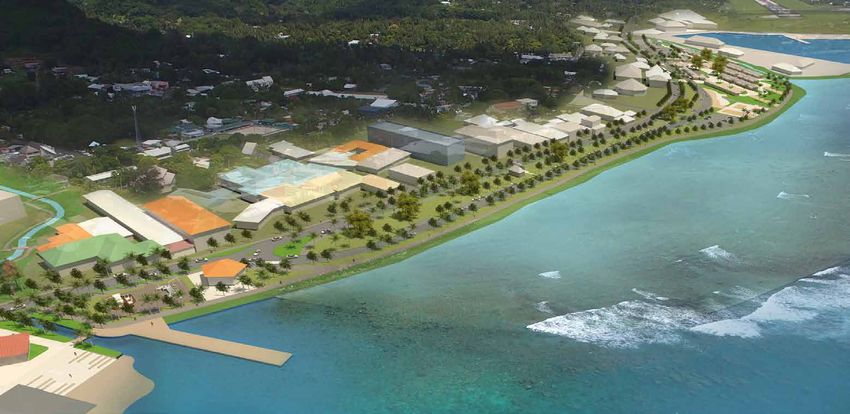
01
BACKGROUND
Introduction | Brief

PROPOSED REDEVELOPMENT SITES                                          THE TOWN PLAN                                                                     Avatiu
                                                                                                                                                       Harbour
There are three Government owned sites that are to be devel-          As a result of the significant impact the development sites will
oped over the next ten to fifteen years. They are grouped just to     have on the township, a town plan is to be developed that will:                                    1
the west of the harbour and together will span a large area of cen-                                                                                                                         Avarua
tral Avarua.                                                                                                                                                                                Harbour
                                                                      •   Incorporate provisions for multi-modal transportation                      530m
                                                                                                                                                     7 min.
Punanga Nui Market And Constitution Park                                  connections between the three identified sites and the                                               Avarua

This will be masterplanned to be developed as a major public              surrounding communities,
                                                                                                                                                                                        2
destination.                                                                                                                                                                                3

                                                                      •   Provide for the integration and linkages of these new public
                                                                          facilities into the fabric of central Avarua whilst enhancing
                                                                          the area’s character, movement opportunities and public
Parliament House Te Atukura                                               enjoyment.
The new Parliament House Te Atukura will consolidate and house
all the Parliament activities in a generous and welcoming layout      •   Develop a strong public realm and a resilient connected
                                                                          transport system

Central Government Office Vaikapuangi                                 •   Create an open space and street-scape to stitch the central
The Central Government Office Vaikapuangi will eventually ac-             area of Avarua together.                                        LEGEND
commodate all of the combined government services in a single
                                                                                                                                              Proposed Redevelopment Site Locations as
site.
                                                                                                                                              identified by the Cook Islands Investment
                                                                      The Town plan coverage will extend from Avatiu Port to Maraer-          Corporation (CIIC):
All three sites are close to the central area and will create large   enga.
changes to the make-up and movement around the central area.                                                                                  Punanga Nui Market & Constitution Park
                                                                                                                                          1
Together they extend over 2km and the movement / connections                                                                                  Parliament House
                                                                                                                                          2
and open space between them will cover half of Avarua township.
                                                                                                                                          3   Central Government Office Complex
                                                                      TIME FRAME

                                                                      The project will run for 3 months and include public consultation
                                                                      and working with stakeholder groups.

                                                                      It is envisaged that the implementation phase will be stage over
                                                                      several years.

TE TAU PAPA O AVARUA | TOWN PLAN FOR AVARUA TOWNSHIP AREA
                                                                                                        4
DRAFT PLAN REPORT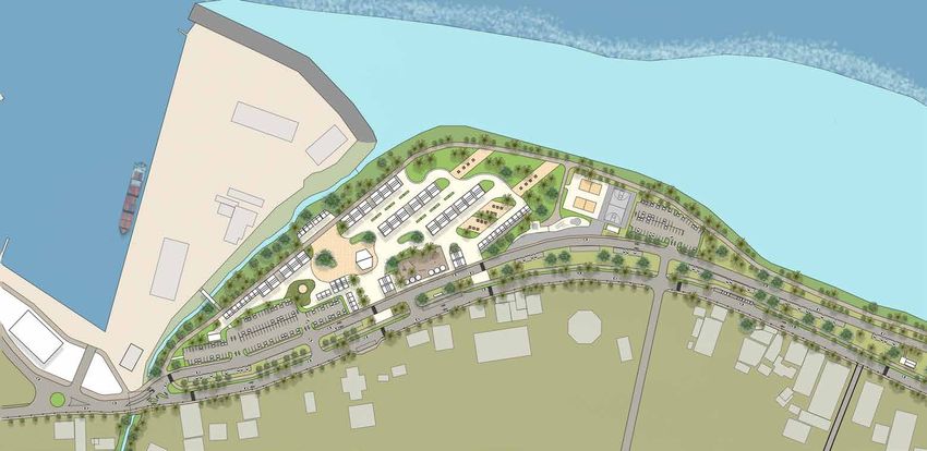
01
BACKGROUND + ANALYSIS SUMMARY
Heritage

                                                                Town Plan 1893

TE TAU PAPA O AVARUA | TOWN PLAN FOR AVARUA TOWNSHIP AREA
                                                            5
DRAFT PLAN REPORT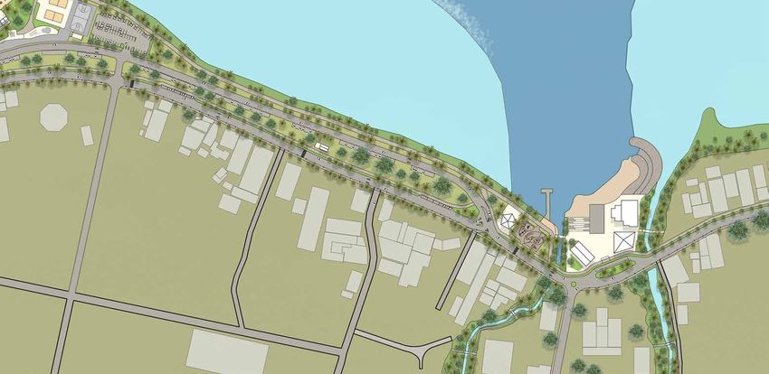
01
BACKGROUND + ANALYSIS SUMMARY
Heritage

                              Tropical Cyclones                                                                                       •   On the leeward side of the island Avarua was formed as a colonial
                                                                                                                                          town and as Rarotonga’s main port and administration centre
                                                  N
                    Avarua
                                                                                                                                      •   There is a two road system around the periphery and a collection of
                                                                                                                                          institutions along the coast with residential mainly to the rear.

                                                                                                                                      •   Recent development has spread the town to the north relocating the
                                                                                                                                          markets and creating the port at Avatiu - further commercial extends to
                                                                                                                                          the airport

                     Predominant Trade-winds
                                                       Formed on Avarua harbour around the pier   Streams being used for recreation
                                                       that transported cargo

  Theological College - The first building in         There are a number of heritage buildings
  Avaura                                              present - not all have been looked after
                                                      well

TE TAU PAPA O AVARUA | TOWN PLAN FOR AVARUA TOWNSHIP AREA
                                                                                                          6
DRAFT PLAN REPORT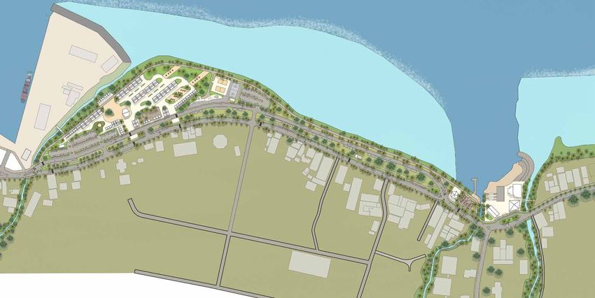
01
BACKGROUND + ANALYSIS SUMMARY
Physical Elements
Land Amenities
LEGEND LEGEND N
Charter fishing
Playground
Reclaimed land boats Street lighting
Contour Public Toilets
Low lying land Bus Stops
Taro plantations Bus route
d ss
alk
Forest vegetation
an ro
W
Isl o C
T
Cook’s Corner Fitness trail
Bus Terminal
Tourist Information
Water Movement
LEGEND LEGEND
Reef Main road - Waterfront connection
Ara
Stream Key Intersections
Tap
Swamps Te ‘Back’ road
A ra
u
Ma Streets
Ara ire
Avatiu Tap Nu Boat + ferry access
Hazard Mapping u i
Swamp 500m walking distance
Ara Tapu
Surge and wave impacted areas
0.5 km 0.5 km
Ruatonga Overtopping wave impact area 6 min 6 min
Swamp Wave overwash area Ara Metu
a
Takuvaine Flooding inundation
Avatiu Stream Takuvaine Stream
Swamp
Vaikapuangi
Stream
TE TAU PAPA O AVARUA | TOWN PLAN FOR AVARUA TOWNSHIP AREA
7
DRAFT PLAN REPORT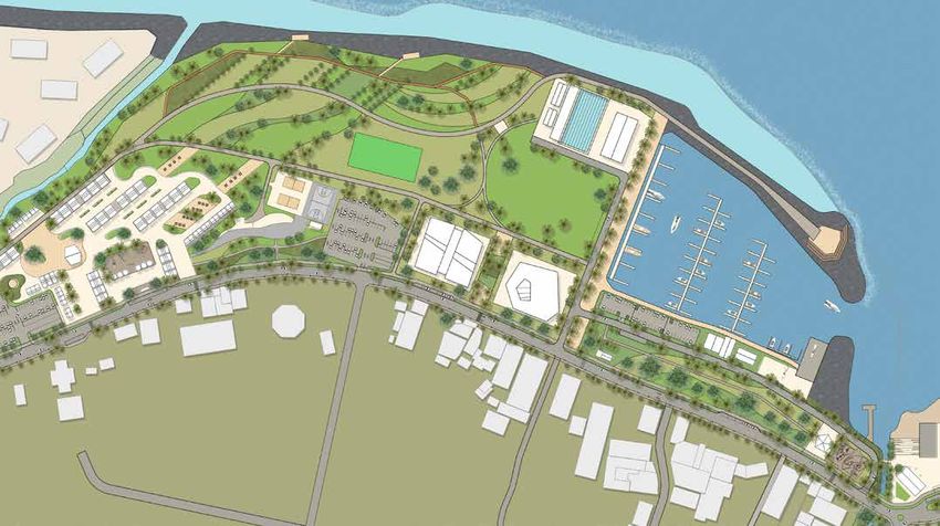
01
BACKGROUND + ANALYSIS SUMMARY
Transportation

ROAD SAFETY HISTORY                                                    PEDESTRIANS AND PUBLIC TRANSPORT                                        TRAFFIC VOLUMES

The recorded crash history indicates a total of 45 fatalities in the   Currently, walkability and pedestrian connectivity is generally of      No traffic counts have been undertaken to date on Te Ara Maire
whole of Rarotonga over the past 10 years:                             a low to moderate standard within the town centre. Footpaths            Nui and Ara Tapu and will be commissioned at a later date.
•     36 in Te Au o Tonga                                              are intermittent and crossings are not well connected. A zebra          Typically, a single lane has capacity to carry 1,800 vehicles per
•     6 in Puaikura                                                    crossing exists on Ara Tapu, west of Tutakimoa Road. However            day (based on an average gap distance of 2 seconds between
•     3 in Takitumu                                                    this zebra crossing does not connect to the harbour-side footpath       vehicles). Currently it is expected that the two-lane roads have
                                                                       on Te Ara Maire Nui and instead delivers pedestrians into the           capacity to cater for traffic growth. With the operation of the
                                                                       median island area within the scooter parking area.                     markets, the peak times of Te Ara Maire Nui and Ara Tapu in
                                                                                                                                               terms of traffic activity are on Saturdays.
                                                                       Improvements for pedestrians would include connecting footpaths
                                                                       to provide a continuous, accessible path for pedestrians and
                                                                       new zebra crossings spaced across both Te Ara Maire Nui and
                                                                       Ara Tapu. This would encourage walking within the town centre
                                                                       itself, provide a viable, suitable and convenient walking alternative
                                                                       so as to reduce short distance car trips, as well as provide a
                                                                       safe path for pedestrians crossing the road to the markets and
                                                                       harbour.

                                                                       The existing public transport service is owned, managed and
                                                                       operated as a private, fully commercial service. To encourage the
                                                                       use of public transport and in turn reduce private car trips, bus
                                                                       stop infrastructure should be located within the main catchment
                                                                       in the town centre with amenities such as bus shelters, seats and
                                                                       footpaths for connection. Further consideration should be given
                                                                       by the Cook Islands Government and its subsidiary departments
A number of crash ‘hot spots’ were identified in along the main        to the establishment of a public transport policy, which may
road in Avarua:                                                        involve the creation of a management and operations contract
•      Punanganui Market                                               to deliver suitable quality and frequency of bus service. The
•      Te Ara Maire Nui                                                implementation could bring about a proportional shift in private
•      Parekura                                                        car travel to public buses.
The majority of the crashes involved motorcycles (34 out of
45 recorded crashes) and 6 involved cars. One involved a
pedestrian.

The types and causes of crashes are inconclusive, although
alcohol was a factor for 39 of the crashes. Out of the motorcycle
crashes, only one was recorded wearing a helmet.

TE TAU PAPA O AVARUA | TOWN PLAN FOR AVARUA TOWNSHIP AREA
                                                                                                         8
DRAFT PLAN REPORT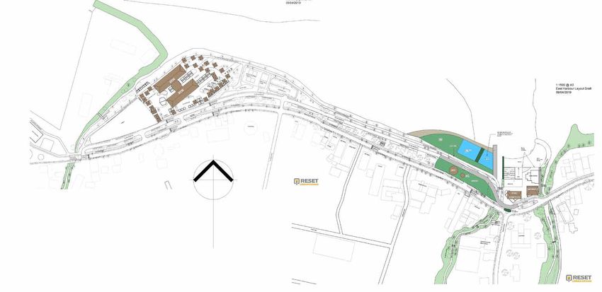
01
BACKGROUND + ANALYSIS SUMMARY
Transportation

AVARUA TOWN PLAN - CURRENT LAYOUT

The current road layout along the harbour is a two-lane, one-way        parking spaces are provided on both sides of the central median.
carriageways direction on both Ara Tapu and Te Ara Maire Nui.           Observation of the parking activity indicated that without time
Ara Tapu, being one-way in the westbound direction is closest to        controls of any of the parking spaces these parking areas are in
the commercial area of the Town Centre and Te Ara Maire Nui in          significant part occupied by workers and take up valuable space
the eastbound direction is closest to the waterfront and lagoon.        that could be available for visitors and shoppers in the Town
The central median separating the two roads is a grassed area of        Centre.
varying width, up to 16m wide. Indented parking bays exist on the
right-hand side of both roads. Some benches and public toilets          The primarially established two-way ‘back road’ Ara Metua, is
are located within the median towards the eastern end. Gaps are         located approximately 450-500m inland of the main road of Ara
provided along the central median, allowing turning maneuvers of        Tapu. It is not a continuous ring road within the town centre,
vehicles between the two uni-directional roadways.                      with vehicles required to travel through a section of Ara Tapu to
                                                                        connect back to Ara Metua as a result of the road passing through
There are sections of footpaths on Ara Tapu, although they are          the church land at the Theological College.
not continuous. A footpath is also present along the lagoon - side
of Te Ara Maire Nui. The indented parking bays are utilised as
angled parking spaces for both cars and scooters. However the
parking spaces themselves are not marked and are used by both
cars and motorcycles parking as and where they wish generally
following the angled parking regime. Approximately 300 car

                                                                                                                                                                   A typical cross-section at the eastern end
                                                                                                                                                             near the CITC shopping centre is shown below.

                                                             2.8m      4.3m          4.3m    3.8m                                            4.8m     4.3m              4.3m         2.6m wide footpath
                                                            Footpath   Te Ara Maire Nui     Parking              16m Central berm           Parking          Ara Tapu

TE TAU PAPA O AVARUA | TOWN PLAN FOR AVARUA TOWNSHIP AREA
                                                                                                        9
DRAFT PLAN REPORT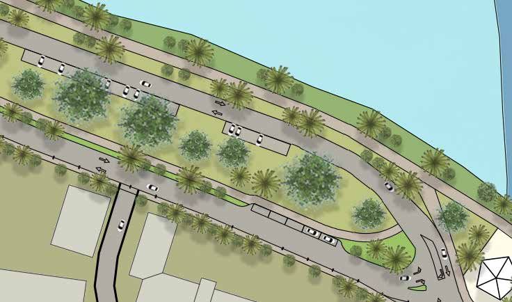
01
BACKGROUND + ANALYSIS SUMMARY
Land-use
LEGEND:
N
1 Avatiu CULTURAL / HISTORICAL SERVICES
Harbour
1 1 CITC Supermarket
St. Joseph Cathedral
2 SDA Church 2 CITC Building Centre
3 3 3 Punanga Nui Market
Wreck of RMS Maitai “The Bolier”
2 4 CITC Foodland
4 Palace of Makea
13 5 Avarua Shopping Centre
1 5 Museum of Cook Islands
2 6 Trader Jacks
6 CICC Church
3
3 7 Cemetery EDUCATION
Avarua
1 Harbour 8 Beachcomber 1 St. Josephs School
10 9 Old Coral Homestead - built at time of 2 University of South Pacific
4 missionaries 3 Avarua School
5 10 Mitchell House 4 Takamoa Theological college
8 9 11 Nicolas House
6 6
11 5
1 7 4 9
AMENITIES LAND USE LEGEND:
12 1 Tennis Courts
8 6
2 Sports Fields Commercial
1111 7 7
10
10 3 Cooks Islands Ports Authority
2 4 Cook Islands Port Residential + Visitor
5
5 Cook Islands Police Accommodation
6 Avarua boat ramp
3 7 Tourist Information Agriculture
2 4 8 Courthouse
• Linear town arrangement backed
9 CICC Mission House by residential
10 Central Government Office Complex • Facilities spread out
Parliament House • Government buildings located to
11
east of town
12 Bowling Club
• Food outlets along waterfront
13 Constitution Park
0 50m 100m 300m 600m
TE TAU PAPA O AVARUA | TOWN PLAN FOR AVARUA TOWNSHIP AREA
10
DRAFT PLAN REPORT01
BACKGROUND + ANALYSIS SUMMARY
Issues
1. The township is exposed and vulnerable to cyclones. The Town Plan
design needs to be robust and where possible, help reduce the level
of wave run up and accommodate sea level rise
2. Mostly hard-stand surfacing around Avarua Harbour. The foreshore is
made up of concrete working edges, and poor quality rock seawalls
which are virtually inaccessible. The foreshore needs to be opened
up, usable and welcoming to the public
3. Conflict between markets and car park, and well as poor connection
between the centre of town and the markets. Parking needs to be
reconfigured to ensure a smooth transition and safe access during
market days, as well as not providing barrier too much empty space
during weekdays when smaller market space is needed.
1. Storm surges 2. Limited water access + interaction 3. Difficult access to markets
4. Limited connectivity of pedestrian network. Footpaths disjointed in
poor state of repair and do not provide appropriate safe connections.
5. Port edge with undefined pedestrian route. Needs to be defined so
when ports are in operation, the public feels safe and are safely out of
the way of the operations
6. Poorly maintained and treated streams and margins which have
been channelised in some places. Need to be reparied where
appropriate and replanted. Also, oppportunity for pedestrian links
along stream corridors
4. Poor pedestrian network + vehicle 5. Lack of pedestrian provision at Port 6. Degraded streams
dominance
TE TAU PAPA O AVARUA | TOWN PLAN FOR AVARUA TOWNSHIP AREA
11
DRAFT PLAN REPORT01
BACKGROUND + ANALYSIS SUMMARY
Key Considerations
10
Larg
e Se
para
tion LEGEND
N
1 No pedestrian provision around port
Lin
2 Markets don’t day-light with Port
ea
rs
Avatiu 3 Reclaimed open space foreshore behind markets
trip
Harbour Split roads - barrier 4 Poor edge interaction / access to sea
o
f re
Port 5 between town and sea 5 Low quality marine environment
tail
1 4 and activity in median
6 Small swimming area and jetty next to Trader Jacks
+c
3
Avarua
omm
7 Hidden bus station
Harbour
2 8 Hard to find Tourist information
erci
9 Neglected, channelised streams
al
11 10 Limited cruise ship access
4
11 Large, wide roundabout
12 Incomplete road network
6
13 Two new large complexes will stimulate urban development
7
8
9
11
ADDITIONAL POINTS
9
12 13 • Spread out facilities
13
• Poor disjointed footpaths without adequate street lighting
• Minimal or no shaded/covered walkways along foreshore
Ba
• Swimming in open harbour areas can be dangerous with
ck
roa strong currents
d alternative 9
Li n
ea
• Heavy rains discharge rubbish, debris and waste from streams
rs 12 into lagoon / ocean
tri
p
of
re
sid
en
tia
l
0 50m 100m 300m 600m
TE TAU PAPA O AVARUA | TOWN PLAN FOR AVARUA TOWNSHIP AREA
12
DRAFT PLAN REPORT01
BACKGROUND + ANALYSIS SUMMARY
Vision, Principles + Objectives
Support sustainable and resilient land use and community
development for Avaura Township
VISION
Developing the Providing Supporting the
Integrating social
PRINCIPLES
township’s healthy Enhancing the easy and safe development of
and physical
recreational environment and public access the townships
functions of the
activities and it’s resilience and circulation broad-based
town
cultural facilities throughout economy
OBJECTIVES
Interactive Multi-modal Generous Enhance Resilience Celebrate
Community Accessibility Public Space Ecology Infrastructure Heritage
TE TAU PAPA O AVARUA | TOWN PLAN FOR AVARUA TOWNSHIP AREA
13
DRAFT PLAN REPORT01
BACKGROUND + ANALYSIS SUMMARY
Feedback from Initial Design Options
GENERAL AREAS OF AGREEMENT RESPONSE
• A Town Plan is overdue- to better coordinate development • Water Drainage to be further out to sea • All items agreed on to be retained and split over 2 stages (no
• Bus parking / interchange supported - especially for public servants • Extension of path to airport reclamation and waterfront park reclamation)
• Upgraded Public transport – including the proposed hub at RFC • Extension of the fitness trail • There will be in a integrated transport plan delivered as part of this
(Avarua Harbour) • Constitution park is exposed- design needs to accommodate this project
• Need for landmark / pivotal point along waters edge • Road lighting needs to be improved • Wastewater and drainage are outside of this scope but are important
• Working with offices to promote healthy lifestyle • Markets needs improved bus stops and specific traffic management • Land ownership is respected - no proposals to take land
• Footpaths are an important connection • Staged construction process agreed as most practical
• Parking and cycle connections are needed • Need to respect and work with existing land ownership
• Culture and heritage needs real recognition and community • Most agree that the project could be staged with the large reclamation
ownership as the ultimate goal
• Upgraded on-land wastewater system is required - micro treatment or • Most like the idea of encouraging walking along coastal promenade
wetland seepage systems are recommended alternatives
OPTION THREE (STAGE 1) FEEDBACK RESPONSE
• Connected back road and cross-roads required but will have land • Back and cross roads will moved into a future stage
tenure and road widening issues • Te Ara Maire Nui will be kept until the back road network is completed
• Play-space and bus hub are a Stage 1 priority
• Variation in driver expectations with the 30km/h town centre
carriageway and 50km/h through movement carriageway - some
believe there will be “mayhem” if the four lanes are reduced to two.
Others believe there is too much road and separation from the sea.
• Play-space and bus stop supported.
TE TAU PAPA O AVARUA | TOWN PLAN FOR AVARUA TOWNSHIP AREA
14
DRAFT PLAN REPORT01
BACKGROUND + ANALYSIS SUMMARY
Feedback from Initial Design Options
OPTION TWO (STAGE 2) FEEDBACK RESPONSE
• Most agree with the concept of the salt-water pool for learning to swim • This option will be split between Stage 1 and the original Stage 3 (so
and recreation there are now just the 2 stages)
• Marina for yachts would contribute to the economy • Beach upgrades to happen in Stage 1
• Consistent street lighting needed • Marina and pool retained but becomes part of the reclamation in \
• Fishing clubhouse would fit well but there are reserve land issues Stage 2
• Improved street lighting will be provided in Stage 1
• Rear parking to be moved to a future stage
OPTION ONE (STAGE 3) FEEDBACK RESPONSE
• Seen as the long term vision • Reclamation to be carried out in Stage 2 for larger waterfront park
• Agree with the big vision concept of major reclamation • Design of park done in a way that Te Ara Maire Nui can be kept, but
• Market parking close to intersection seems sensible removed at a later date without creating redundant works
• Involvement of private sector supported • Parking provision on reclamation
• Parking provision within the reclamation • Facilities retained
• Increased harbour capacity for local island vessels • Additional port hard-stand area retained
• Conference and cultural facilities • Rear drainage alternative provided as well as areas of low planting at
• Schools may use the facilities the front of the reclamation which could be used as retention / filtration
• Ports are wanting more container space (on land)
• Possible drainage alternative / retention across the re reclamation
• The reclamation ‘zeroes’ the inter-reef distance and would need to
protect the rich ecosystem
TE TAU PAPA O AVARUA | TOWN PLAN FOR AVARUA TOWNSHIP AREA
15
DRAFT PLAN REPORT01
BACKGROUND + ANALYSIS SUMMARY
Coastal Strategies
Secondary flow path
to rear of wall with low
planting for increased
habitat and wave run up
reduction
Sloped, porous seawall
with Increased level to
allow for sea level rise
Maintain existing coral
reef as barrier
Use harbour dredgings to
form reclamation
Large lawn area on
shallow slope
Larger buildings set back
inland on stilts
Small, light ,stilted
buildings on foreshore
ADOPTION STRATEGIES:
• Maintain existing property + infrastructure in current location
• Use a natural system approach to provide protection PRECEDENT: ALA MOANA BREACH PARK HONOLULU
• Allow for sea level rise • Uses coral reef to create a barrier
• Create a wide green sponge in the form of a park to assist in • Large reclamation formed from harbour dredgings
adsorbing storm surges • Large recreational facility - beach, hard courts, open space,
• Provide for new recreation and cultural facilities promenade, marina
Sources: • Seawall around marina
1. Science Direct. Future of our coasts: The potential for natural and hybrid
infrastructure to enhance the resilience of our coastal communities, economies
and ecosystems approaches. Ariana E.Sutton-Grierab, Kateryna Wowkac & Holly
Bamford
2. Hawaiʻi Climate Change Mitigation and Adaptation Commission. 2017. Hawaiʻi
Sea Level Rise Vulnerability and Adaptation Report. Prepared by Tetra Tech, Inc.
and the State of Hawaiʻi Department of Land and Natural Resources, Office of
Conservation and Coastal Lands, under the State of Hawaiʻi Department of Land
and Natural Resources
TE TAU PAPA O AVARUA | TOWN PLAN FOR AVARUA TOWNSHIP AREA
16
DRAFT PLAN REPORT02 | MOVING FORWARD
TE TAU PAPA O AVARUA | TOWN PLAN FOR AVARUA TOWNSHIP AREA
17
DRAFT PLAN REPORT02
TE TAU PAPA O AVARUA | AVARUA TOWN PLAN DRAFT
FOR INTERNAL REVIEW
Draft Town Plan | Stage One 28/03/2019
Cycle/Walkway to airport
LEGEND Marina extension for
non-masted craft
N
Extent of current coastal edge
Carriageways
Reef
New Fishing Clubhouse
Reserve / Open space
New Commercial Zones
Sports:
Market Space
1/2 basketball court
Feature Gardens Skate park
Pedestrian Promenade Port
Volley ball
Beach New Street lighting
Pedestrian + cycle
Car parking
Markets promenade
Key roundabouts Markets
New Ports Building
Play-space
KEY MOVES Pier
Upgrade roundabout
(including single port Re allocated carparking Rock Groyne extension
• Create a high quality urban access leg) New Bridge
beach at Avarua Harbour Replenished beach
• Upgrade existing marina Provide footpath
continuity + lighting
• New fishing clubhouse New tourist
Information kiosk New Bridge
• Introduce walkways on waterside Bus hub
2 x buses + shelter
• New waterfront park with Upgraded round-
playing field, hard-courts and about
playground
• Existing roads retained along
esplanade - seaward a bypass,
landward a slow route
New back route
• Markets and carpark Upgraded stream connection
reorganised corridor (“Missing link”)
• New back route connection
• New bus hub
0 50m 100m 300m 600m
TE TAU PAPA O AVARUA | TOWN PLAN FOR AVARUA TOWNSHIP AREA
18
DRAFT PLAN REPORT02
TE TAU PAPA O AVARUA | AVARUA TOWN PLAN
Draft Town Plan | Stage One | Market Layout
Double faced kiosks
Picnic areas
Volleyball courts
Basketball court
Car parking (63 spaces)
New weir to reduce
storm surge
JOIN LINE
Retain existing central
space
4m wide Coastal promenade
New marina pathway
Skate park
New promenade
Footpath continuity
+ lighting
Car parking
(134 spaces)
New bridge
1:2000 @ A3
TE TAU PAPA O AVARUA | TOWN PLAN FOR AVARUA TOWNSHIP AREA
19
DRAFT PLAN REPORT02
TE TAU PAPA O AVARUA | AVARUA TOWN PLAN
Draft Town Plan | Stage One | Revitalised Harbour
N
Pedestrian Promenade
Two-way bypass
Childrens play-space
3m wide timber pier
Stepped tidal steps
New tourist information kiosk
JOIN LINE
Footpath continuity
+ lighting
New bridge with wide
footpath
Footpath
Upgraded streams with New central bus hub
new footpath connections and shelter
1:2000 @ A3
TE TAU PAPA O AVARUA | TOWN PLAN FOR AVARUA TOWNSHIP AREA
20
DRAFT PLAN REPORT02
TE TAU PAPA O AVARUA | AVARUA TOWN PLAN
Draft Town Plan | Stage One
TRANSPORT
In Stage One, both Te Ara Maire Nui and Ara Tapu would be the current on-street parking arrangement. A number of indented
converted into a pair of two-way carriageways. Te Ara Maire Nui parking bays would be retained within the central median. These
would serve as a “bypass” or the town centre and Ara Tapu would spaces would be re-marked to reflect the direction of travel of the
be retained as a local road subject to a slower speed zone. The adjacent traffic lane. By re-marking the spaces and through on-
tie-in intersections of these roads would be designed to provide going maintenance of the road markings, the effective use of the
priority for vehicles traveling through Te Ara Maire Nui. parking spaces would be maximised. Specific areas for parking
motorcycles would also be provided closest to the main hubs of
Ara Tapu would have a speed environment dictated by the activity.
presence of kerbs and footpaths on both sides. A 2m continuous
footpath is proposed on the southern side. On the northern side a As part of the Vaikapuangi government office development
3m promenade is proposed, suitable for use by bikes, pedestrians process, two additional areas of government-owned land have
and cyclists. Along the harbour, a 4m wide promenade is been identified to provide approximately 150 off-site parking
proposed linking back to the main footpath on Ara Tapu. spaces for use by employees of the new office. Within the office
complex itself, it is estimated to provide 100 car park spaces, Section Location
A number of zebra pedestrian crossings would be provided on including provision for government pool vehicles and staff
Te Ara Maire Nui and Ara Tapu to provide safe crossing point vehicles.
connections and promote walkability between the town centre and
the markets and harbourside promenade. To promote the exposure of public transport and shorter
walking distance between the main catchment in the town
Car parking areas would be provided on the harbourside, centre, bus stops would be established and spaced along Ara
accessed from Te Ara Maire Nui. These car parks are situated Tapu. Consideration would also be given to a new bus hub /
adjacent to the markets and recreation areas, relocated from enhancement of a bus stop facility adjacent to the Avarua
roundabout/ Trader Jacks. A typical cross-section at the eastern end
near the CITC shopping centre is shown below.
Redesign of existing public space 3.5m 3.5m 4.5m 2.6m 4.3m 4.3m Upgraded 2m wide
with 4m promenade Te Ara Maire Nui Parking Existing Central berm with new 3m promenade Parking Ara Tapu footpath
TE TAU PAPA O AVARUA | TOWN PLAN FOR AVARUA TOWNSHIP AREA
21
DRAFT PLAN REPORT02
TE TAU PAPA O AVARUA | AVARUA TOWN PLAN
Draft Town Plan | Stage One | 3D
TE TAU PAPA O AVARUA | TOWN PLAN FOR AVARUA TOWNSHIP AREA
22
DRAFT PLAN REPORT02
TE TAU PAPA O AVARUA | AVARUA TOWN PLAN DRAFT
FOR INTERNAL REVIEW
Draft Town Plan | Stage Two 28/03/2019
LEGEND
Extent of current coastal edge
Ports extension Extent of reclamation inside reef N
Reef Pedestrian Promenade
Reserve / Open Space /
Playing Fields Avatiu Navigation / Voyaging / Canoeing School
Carriageways Harbour
Feature Gardens Salt Water Swimming Pool + Water Park
Pedestrian Promenade
Port
Cover to Pedestrian Promenade
New Vaka house, launch ramp
and carpark
Markets
New Marina
KEY MOVES
Reef
Avarua
• Extend foreshore inside reef
Harbour
edge to create large new Museum / Art Gallery
waterfront park Playing field
• Waterfront promenade Cultural Centre
Addition of covered
• Cultural / historical information Walkway
• Space for playing fields
• New marina for small boats,
Vaka house and launch ramp
• References the traditional wind
/star compass
• Historical traditional monuments
and more iconic buildings
- reflective of Cook Islands
culture & traditions
• Back street gird connected
• New marina and pool
• New vaka house and launch
ramp
0 50m 100m 300m 600m
TE TAU PAPA O AVARUA | TOWN PLAN FOR AVARUA TOWNSHIP AREA
23
DRAFT PLAN REPORT02
TE TAU PAPA O AVARUA | AVARUA TOWN PLAN
Draft Town Plan | Stage Two | Waterfront Park
New storage facilities.
Extend port area Lookouts N
Boardwalk through
wetlands / gardens
Swimming pool
Navigation / Voyaging / Canoeing
School
Junior rugby field
Marina
Informal playing field
Pedestrian promenade
Seawall
Lookout
Car parking
(101 spaces)
Marina shared facility
Vaka house
Maneuvering space and
boat ramp
Museum / art gallery
Cultural centre
Back street grid connected
and lit
1:2000 @ A3
TE TAU PAPA O AVARUA | TOWN PLAN FOR AVARUA TOWNSHIP AREA
24
DRAFT PLAN REPORT02
TE TAU PAPA O AVARUA | AVARUA TOWN PLAN
Draft Town Plan | Stage Two
TRANSPORT
Currently there are approximately 320 unmarked spaces for cars
With the removal of Te Ara Maire Nui and utilisation of the space along the central median, which will be removed and reinstated
for the waterfront park / recreation area, the lane capacity on Ara elsewhere as part of Stage Two. With the intention of reducing
Tapu is expected to be 3,200 vehicles per day (twoway). Traffic traffic in this part of town but expectation that there will remain a
bypassing the town centre and some of these vehicles with practical need to provide suitable levels of employee, customer
destinations within the Town Centre would be re-directed to Ara and visitor parking, some spaces will need to be reinstated within
Metua, the ‘back road’. As part of the upgrade of Ara Metua, a the car parking areas and on-street parking.
connection linking back to Ara Tapu would be upgraded to cater
for the additional traffic using this route. Efficiency of traffic flow
would also be improved by providing this bypass route separate
from the pedestrianised environment. It is expected that Ara Tapu
would have sufficient capacity to cater for traffic. In the next stage
of works, traffic modeling and assessment will be undertaken to
determine the traffic flow on these roads and how to best mitigate
these either by road upgrades or improved connections. Section Location
The connectivity and safety of pedestrian movement within the
town centre would be improved by minimising the total length of
road to cross and potential conflict points as well as promoting
the visibility and priority of pedestrian movements within the Town
Centre over vehicle movements. An area of recreation separate
from traffic will be expanded on the harbour. Narrow traffic lanes
would be provided around the cultural hub and to access the car
park on the eastern end.
A typical cross-section at the eastern end
near the CITC shopping centre is shown below.
Marina Vaka house 3m 3m New waterfront park 2.6m 4.3m 4.3m Footpath
Access to Parking Ara Tapu
Vaka house
TE TAU PAPA O AVARUA | TOWN PLAN FOR AVARUA TOWNSHIP AREA
25
DRAFT PLAN REPORT02
TE TAU PAPA O AVARUA | AVARUA TOWN PLAN
Draft Town Plan | Stage Two | 3D
TE TAU PAPA O AVARUA | TOWN PLAN FOR AVARUA TOWNSHIP AREA
26
DRAFT PLAN REPORT02
TE TAU PAPA O AVARUA | AVARUA TOWN PLAN
Draft Town Plan | Staging
LEGEND
Stage 1
Stage 2
Existing foreshore line
TE TAU PAPA O AVARUA | TOWN PLAN FOR AVARUA TOWNSHIP AREA
27
DRAFT PLAN REPORT02
TE TAU PAPA O AVARUA | AVARUA TOWN PLAN
Draft Town Plan | Overview
N
1:3000 @ A3
TE TAU PAPA O AVARUA | TOWN PLAN FOR AVARUA TOWNSHIP AREA
28
DRAFT PLAN REPORT03 | APPENDICES
TE TAU PAPA O AVARUA | TOWN PLAN FOR AVARUA TOWNSHIP AREA
29
DRAFT PLAN REPORT03
TE TAU PAPA O AVARUA | AVARUA TOWN PLAN
Stage 1 Draft Option
TE TAU PAPA O AVARUA | TOWN PLAN FOR AVARUA TOWNSHIP AREA
30
DRAFT PLAN REPORTTE TAU PAPA O AVARUA | TOWN PLAN FOR AVARUA TOWNSHIP AREA
31
DRAFT PLAN REPORTYou can also read


