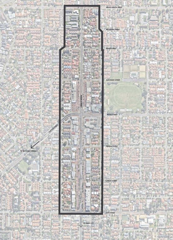
Main Street Urban Design Study - Transport Plan As Adopted by Council 25 February 2020 - City of Stirling
←
→
Page content transcription
If your browser does not render page correctly, please read the page content below
Main Street Urban Design
Study
Transport Plan
As Adopted by Council
25 February 2020
2

  Terrible streetscape, busy traffic, the design is
focused more on traffic and less around people -
              the wrong way around!

             (2017 Online Survey Responses)
3

Contents

4……….Introduction

5……….Bus Stop Configuration

7……….Speed Zoning

17……..Carriageway Design Elements

25……..Pedestrian Prioritisation

29……..Bicycle Access

33………Transport Plan Outcomes

36.……Appendix 1 – Main Street Urban Design Study
Initial Analysis
4

Introduction
The Transport Plan for the Main Street Urban Design Study (Study) has been
developed in conjunction with the City of Stirling and RobertsDay Group.

This plan has been completed to address a number of key elements to the study
area, namely:

• Examination of bus bay location and design along Main Street
• Speed zoning within the Project area
• Carriageway design elements to support some of the outcomes raised by the
  community during the engagement process for the Study
• Pedestrian prioritisation and crossings of Main Street and Royal Street
• Use of Waterloo Street for bicycle priority.

In November 2017, Flyt produced a separate summary review of the transport
network which assisted the engagement process related to this Study. For
reference purposes, this prior informative document is attached to this Transport
Plan as Appendix 1.

                                                                                    Figure 1 Proposed street environment for Main Street Urban Design Study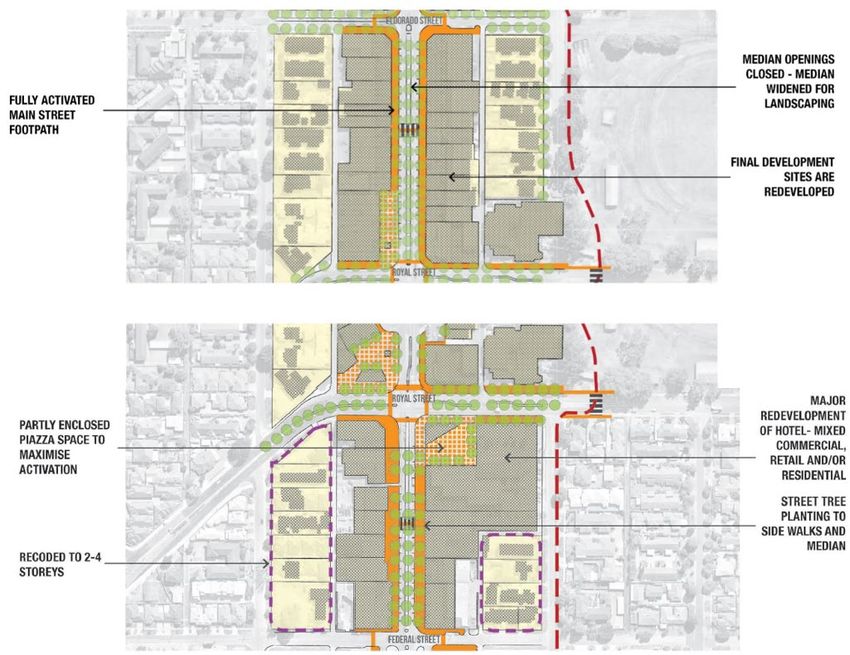
Bus Stop Configuration
6

Bus Stop Configuration                                                               PTA would lead this process in agreement with the City of Stirling. Design
                                                                                     elements would be undertaken collaboratively with Council including resolving
Main Street has three bus routes which run along the central section of the study    issues of timing, funding and other design requirements (drainage, lines and
corridor and one route that runs along Hutton Street and Royal Street. Services      signs, paving etc.) .
are:

•   Route 402 runs between Stirling Station and Perth Busport
•   Route 404 connects to Perth Busport and terminates on Waterloo Street
•   Route 414 connects between Stirling Station and Glendalough Station
•   Route 403 runs along Hutton Street and Royal Street connecting Stirling
    Station with Perth Busport.

There are presently five separate timed or terminus stops in the area as shown to
the right. One of the key elements to the overall plan is to reflect a more
contemporary approach to bus stop configurations in the project area by
eventually removing embayments. This would assist in achieving both built form
and transport outcomes sought from the plan.

At present, the stops on Main Street that are embayed satisfy the requirements of
the PTA Bus Planning and Design Guidelines for Efficient People Movement:

“Embayments should be provided at timed stops where buses may be required to
stop for 90 seconds or more and at locations where there are safety concerns
with passing a stationary bus on a two way street”.

With implementation of proposed changes to the overall network proposed in this
plan, the removal of embayed bus stops can be facilitated by the PTA. This can be
achieved collaboratively with the PTA and the community to improve access,
retain service operation efficiency and contribute to the overall design outcomes.                           Figure 2 Timed bus stop locations (embayed and not embayed) within the Main Street Study Area
Speed Zoning
8

Speed Zoning
Issues relating to speed zonings within the Main Street study area were raised      - Stage 2, implementation of a wider area posted 40km/hr zone that will set a
as both negatives and positives within the community engagement exercise.             clearer location for lower traffic speeds
Many respondents raised the existing 40km/hr trial zone as a positive outcome       - Installation of signalised pedestrian crossing points on both Main Street and
for Main Street.                                                                      Royal Street to act as speed reduction measures, as well as provide for
                                                                                      pedestrian connections
Many people also stated that the low speed zone was a negative. This                - Installation of in-lane speed reduction devices (low level ramps, raised safety
response is indicative of the way people presently see Main Street – they             platforms or cushions) on Main Street, Royal Street and Hutton Street
perceive it as a fast “road”, with a reduction in speed zone simply an              - Reduction of the traffic carriageway widths along Main Street to denote key
inconvenience or burden for their vehicle trip. In part, this response could also     activity areas with increased width for pedestrian movements and street
be borne out of the fact that the street design itself did not incorporate            furniture
management measures. Many studies have concluded that, in order to achieve          - Introduction of on-street parking along Main Street and Royal Street in
a reduction in speed within an urban environment, a combination of lower              conjunction with the Robinson Reserve works and this Study
posted speed limit and physical measures are required.                              - Removal of bus embayments along Main Street and Royal Street to better
                                                                                      utilise street carriageway space
Stage 1 includes the present 40km/hr speed trial which will continue into           - Use of templates and other elements such as planting to introduce
2019 with the City of Stirling actively monitoring the outcomes of the trial.         psychological measures to reduce speeds
Since the introduction of the posted speed trial, the monitored results indicate    - Removal of free slip turn lanes from Hutton Street to Main Street to reduce
an average 6% reduction in the daily recorded 85th percentile throughout the          approach and exit speed of vehicles
area. The overall 85th percentile speed is still on average around 55km/h. This     - Removal of turning pockets along Main Street to create additional street
initial assessment highlights that there needs to be a combination of measures        planting and reduce turning vehicle priority.
to achieve meaningful change in driver behaviour, as well as greater definition
around the overall speed zone.                                                      Examples of how these measures have been introduced in other Perth
                                                                                    locations, individually or collectively to reduce speeds, improve amenity and
To achieve the step change in overall driver behaviour required to match the        support urban improvement outcomes are set out in the following table. This is
outcomes sought from the community, a range of measures are being                   to demonstrate that what is proposed for Main Street can, and has been,
proposed within this plan. The proposals to achieve the outcomes for reducing       achieved.
speed within the Study area are: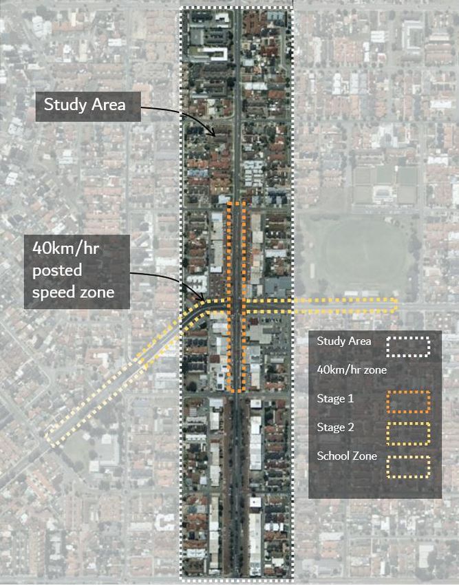
9

Speed Zoning
Element                                Example                                   Outcome                                                           Benefits

Implementation of a wider area         Rokeby Road and Hay Street corridor       Monitoring sites show 85th Percentile under posted speed      -   Improved safety for pedestrians, cyclists and
posted 40km/hr zone that will set      through Subiaco – District Distributor    limit.                                                            drivers
a clearer location for lower traffic   level roads through an Activity Centre.                                                                 -   Additional travel time is negligible
speeds.                                Implementation of 40km/hr on both                                                                       -   Reduced stopping distance for drivers
                                       roads.                                                                                                  -   Reduced noise levels consistent with appropriate
                                                                                                                                                   conversation amenity
Installation of signalised             Pedestrian signals on Albany Highway in   Monitoring sites show 85th percentile under posted speed      -   Improved pedestrian amenity and safety
pedestrian crossing points on          40km/hr zone near intersection of         limit.                                                        -   Better pedestrian permeability and access within
both Main Street and Royal Street      Duncan Street.                                                                                              Main Street area
to act as speed reduction
measures, as well as provide for
pedestrian connections.
Installation of in-lane speed          Mandurah Terrace, use of low level        Monitoring sites show 85th percentile under posted speed      -   Effective traffic management controls to reduce
reduction devices (low level           ramps and platforms.                      limit.                                                            speed
ramps/raised safety platforms or                                                                                                               -   Reduction in crashes
cushions) on Main Street, Royal        Albany Highway in Victoria Park .
Street and Hutton Street.
Reduction of the traffic               Variety of examples in Activity Areas     More attractive urban spaces and places, no impact on total -     Improved integration of land use and amenity
carriageway widths along Main          such as Fremantle, Cambridge Street,      traffic volumes but more balance in integration of transport -    Easier for pedestrians to cross Main Street
Street to denote key activity areas    Scarborough Beach Road.                   and land uses and improved amenity.                          -    Improved pedestrian amenity and safety
and widen out space for
pedestrian movements and street
furniture.
Introduction of on-street parking      Cambridge Street west of Jersey Street    Posted speed limit is 60km/hr through area but monitoring     -   Slower vehicle speeds mean increased safety
along Main Street and Royal            – on-street parking area along two-lane   traffic data shows that the 85th percentile is closer to      -   More efficient than off street parking and a better
Street in conjunction with the         carriageway where there is commerce       45km/hr for the entire weekday. This demonstrates the             land use
Robinson Reserve works and this        and activity.                             “friction” of on-street parking that forces drivers to slow   -   Often shows a high turnover and higher use than
Study.                                                                           down, even if the posted speed limit is high.                     off-street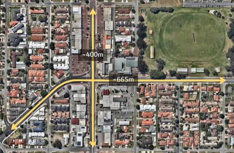
10

Speed Zoning
Element                           Example                                          Outcome                                                          Benefits

Removal of bus embayments         Removal of existing embayment on Main            No impact on operations, provides immediate example of           -   Increase in footpath space
along Main Street and Royal       Street.                                          ability to remove embayment and contribute to altering           -   Acts as speed deterrent on Main Street
Street to better utilise street                                                    the street landscape.                                            -   Reflects PTA policy
carriageway space.
Use of templates and other        Beaufort Street south of Walcott Street.         Monitoring sites show 85th Percentile at or just above           -   Psychological measures have been shown to be
elements such as planting to                                                       posted speed limit during the weekday times of                       effective at reducing driver speeds
introduce psychological                                                            operation. Median speeds are below posted speed limit.           -   More greenery can reduce the urban heat island
measures to reduce speeds.                                                                                                                              effect

Removal of free slip turn         Design of street network in established          Activity areas where slip lanes for traffic do not exist carry   -   Improved amenity and user friendliness for
lanes from Hutton Street to       urban areas of Perth and Fremantle where         far greater amenity for all users.                                   pedestrians
Main Street to reduce             slip lanes and traffic based priority are not
approach and exit speed of        common place because places were not
vehicles.                         historically designed around prioritising fast
                                  or “optimised” traffic speeds as the key
                                  outcome.
Removal of turning pockets        Examples where road carriageway space has        Greater overall urban amenity.                                   -   Greater overall urban amenity
along Main Street to add in       been reallocated for on-street planting such
additional street planting and    as Cambridge Street, design of Claremont
reduce turning vehicle            on the Park and Bayview Terrace and
priority.                         Beaufort Street north of Walcott Street.
11
Speed Zoning
The proposed 40km/hr speed zone for the Main Street is shown to the right.
The overall approach for the traffic management elements and other measures
is set out in the Transport Plan section of this report.
The broad zone covers:
Stage 1
- The existing 40km/hr trial zone that extends along Main Street from
Eldorado Street to Federal Street.
Stage 2
- On Royal Street from Albert Street extended to the intersection of Main
Street
- Royal Street near eastern end of Robinson Street to the intersection of Main
Street.
School Zone
- To continue existing operation, however during peak school times it will
connect to the proposed Stage 2 40km/hr zone.
In order to address the specific elements of Main Roads WA requirements for
speed zones, each criteria element has been examined on the following pages.
Figure 3 Proposed 40kmhr speed zone12 Warrant for Permanent Linear Speed Limit Reduction to 40km/hr Main Roads WA outlines the conditions which warrant consideration of a reduced linear speed zone. These conditions are listed below. 1. The road section shall be fully contained within a recognisable and dedicated tourist, recreation, conservation, shopping, commercial or industrial area / precinct / reserve: The location for Stage 1 speed zone along the north-south corridor is contained within the commercial/retail precinct of Main Street and is clearly identifiable from the residential precinct. The zone facilitates a priority pedestrian environment, creating a safer setting for pedestrians. Longer term, parked vehicles will have limited frontage access to properties along Main Street as parking access will be located behind properties and access to parking via laneways running Figure 4 Main intersection of Hutton/Royal Street and Main Street parallel to Main Street. The Stage 2 speed reduction is along Royal and Hutton Street. Land use either side is zoned development, local centre, public open space and civic. A small portion of residential land use is found on the north and south of Hutton Street and along the south side of Royal Street. As Hutton Street runs adjacent to the primary school, it already changes to a 40km/hr zone during peak school times. Extending the proposed 40km/hr zone permanently along the full length from the study area to where it abuts the school zone will provide road users with a consistent speed throughout the day and signal to road users to stay alert and take extra care.
13

Warrant for Permanent Linear Speed Limit
Reduction to 40km/hr
2. Two-way single carriageway roads shall have a seal width of at least 5.0 metres:

The sections of Main Street, Hutton Street and Royal Street proposed for the reduced speed
zone are two-way dual carriageway roads, with a medians separating each carriageway to
facilitate right turn auxiliary lanes. Main Street (figure 5a) and Royal Street road widths are
approximately 6.4m. Hutton Street, west of the main intersection, is approximately 6.9-7.0m
wide.

3. Traffic volumes shall exceed 100 vehicles per day on a typical weekday;                                        Figure 5a Carriageway widths on Main Street

Traffic volumes along Main Street and Hutton/Royal Street within the study area significantly
exceeds 100vpd. The most recent available average weekday vehicles per day recording
taken from the Main Roads WA Traffic Count Map (figure 5b).

Main St nth – 26,282 vpd     Hutton St – 27,044 vpd
Main St sth – 18535 vpd      Royal St – 17,242 vpd

4. The start and end of the road section should have a threshold treatment

As per section 3.6 of Main Roads WA Local Area Traffic Management, threshold treatments
to identify changed road conditions are not required on roads with more than 4,000vpd.
Notwithstanding this, entrance treatments in the form of on-street speed reduction devices
and template street stenciling are proposed within the overall Transport Plan.
                                                                                                  Figure 5b Traffic volumes at Hutton/Royal Street intersection
14
Warrant for Permanent Linear Speed Limit
Reduction to 40km/hr
5. Minimum length of the speed zone shall be 400 metres;
The current length of the Stage 1 trial zone along Main Street for the reduced speed limit of
40km/hr is approximately 400m. The proposed Stage 2 40km/hr linear speed zone along the
east-west corridor is approximately 665m (figure 6).
6. Mid-block speed-reducing devices shall be provided where the length exceeds 400 metres
or where devices are necessary to create a speed environment consistent with the speed zone
The overall plan is proposed to incorporate measures within the zone, including:
- Signalised pedestrian crossings on Main Street and Royal Street
- Installation of in-lane speed reduction devices (low level ramps or cushions) on Main
Street, Royal Street and Hutton Street, in addition to reduced carriageway lane widths Figure 6 Length of proposed 40km/hr zone along Main Street and Hutton/Royal Street
- On-street parking (outside of peak periods) and removal of bus embayments
- Additional street planting and removal of turning pockets into parking areas
- Removal of free-left slip lane from Hutton Street to Main Street.
The combined outcome of these measures will be to create the form of environment cited in
the Guidelines.15 Warrant for Permanent Linear Speed Limit Reduction to 40km/h 7. The 85th percentile speed for motor vehicles on existing roads, or expected on new roads, shall not be greater than 50 km/h or less than 30 km/h. The current posted speed limit along Main Street is 40km/hr and 60km/hr on the Hutton Street and Royal Street corridor. As set out, monitoring associated with the trial 40km/hr zone has shown that there has been an average of 6% reduction in speeds along Main Street. Additional reduction in speeds would be achieved through local area traffic management and other measures set out in this Plan. 8. Generally all roads within the area shall be local access or local distributor roads in a functional road hierarchy Main Street is classified as a District Distributor A as is Hutton and Royal Streets (see Appendix 1 Road Hierarchy). Although the classification of Main Street and Hutton/Royal Street as District Distributors do not meet the requirements of the above Main Roads WA warrant, this element of the Guidelines is largely redundant as there are a substantial number of District Distributor level roads in Perth which already function as activity corridors and have 40 km/hr posted speed limits, such as: - Albany Highway, Victoria Park (District Distributor B) - Hay Street, Subiaco (District Distributor A) - Beaufort Street, Mount Lawley (District Distributor A) - Fitzgerald Street, North Perth (District Distributor A) - Scarborough Beach Road, Mount Hawthorn (District Distributor A). Given these roads all perform the ultimate function that is being sought for Main Street (with similar traffic volumes, speeds and position in the road hierarchy), this element of the Warrants is considered to be irrelevant.
16

Warrant for Permanent Linear Speed Limit
Reduction to 40km/h
Further Study – Raised Safety Platforms

Raised safety platforms have been used extensively throughout The Netherlands with New
Zealand, the USA and the UK showing interest through pilot projects.
In 2015, VicRoads commissioned a study by ARRB to assess the literature and international
examples for the introduction of raised safety platforms at signalised intersections on
arterial roads (carrying HV’s and buses) with the aim to improve safety and reduce casualty
crashes through speed reduction. The study showed that the introduction of raised safety
platforms can reduce speeds to between 30-50km/hr and in some cases casualty crashes               Figure 7a Aerial of the raised safety platform in Belmont, Victoria.
dropped by 35%.
Since 2015, VicRoads have installed numerous raised safety platforms in Victoria (see
figures 7a and 7b) and the design and installation of the treatment has been formalised,
detailed in their Design Note “Raised Safety Platforms RDN 03-07”. While raised safety
platforms are used throughout Western Australia, their use at signalised intersections and
particularly on arterial roads, has not been explored.
The application of a raised safety platform at the intersection of Main Street and
Hutton/Royal Street appears an appropriate treatment in line with the warrants set out in
the VicRoads Design Note.
It is recommended that the City of Stirling liaise directly with Main Roads WA in order to
assess and progress the ultimate intersection configuration.
                                                                                              Figure 7b Street view of the raised safety platform in Belmont, Victoria.
Carriageway Design and Access
18

Carriageway Design and Access
In order to achieve the desired outcomes of the Study, and provide for integration of transport
and land use for the study area in the future, it is proposed to modify carriageway and access
related elements. These proposed elements are broadly:

-   Reduction in overall lane width of the carriageways where possible (figure 9)
-   Removal of some access points into parking areas (figure 9 and 10)
-   Alteration to access points from side streets to reflect future use
-   Removal of the free turn left slip from Hutton Street into Main Street
-   Use of on-street traffic management devices to reduce speed
-   On-street stenciling and other elements to denote a difference of road space priority
                                                                                                  Figure 8 Road stencilling to create a pedestrian zone, Museum and Francis Street, Perth
-   Changes to parking configuration.

These elements are addressed in this section.
19 Carriageway Design and Access At present, there is variance in carriageway and lane widths within the study area depending on the approach and road section. In order to cater for a range of outcomes (including ability to plant additional street trees, improve pedestrian legibility and contribute to reducing traffic speeds), it is recommended that all carriageways include the following broad elements: - Have a lane width of 3.2m per individual lane - Include medians at a minimum of 2.0m and provide for planting of trees and vegetation to increase street canopy - Design of access ways into side lanes and parking access are designed with minimal radii to reflect slower speeds - Access into side streets and future parking areas are designed to prioritise pedestrians and have a continual surface for pedestrians, not vehicles - Staged removal of access crossovers on Main Street as development progresses as per the planning controls proposed for the area. Figure 9 Carriageway design and access on Main Street The first section that has been designed for alteration, between Eldorado Street and Royal Street, is shown to the right.
20

Carriageway Design and Access
The proposed removal of access points is consistent with the
ultimate design of the Main Street and Hutton/Royal Street
corridor provided by the City of Stirling.

The removal of some access points into existing parking areas is
presently being designed by the City of Stirling. The aim of this
element is to increase the area available to provide future tree
canopy, improve the pedestrian experience of Main Street and
                                                                    Figure 10a Ultimate design of Main Street and Hutton/Royal Street without plaza option
provide for the urban design outcomes within the study.

Figures 10a and 10b show the ultimate design for the guided
redevelopment along Main Street and Hutton/Royal Street, with
reduced access along Main Street and all parking access via rear
laneways.

                                                                    Figure 10b Ultimate design of Main Street and Hutton/Royal Street with plaza option
21
Carriageway Design and Access
Within the existing street network and access points, a number of side street intersections
have been altered to manage traffic flows and address current safety concerns. With the
introduction of measures set out in this plan, the form of intersections and side street access
will need to be examined. This is particularly the case for:
- The intersection of Main Street and Eldorado Street
- The configuration of Federal Street intersecting with Main Street
- Access from laneways adjacent to development sites
- Access to and from Waterloo Street from the adjoining commercial properties.
Any reconfiguration of these intersection or access points should:
- Provide for service access to properties as they evolve and vehicle access points move to
the rear of each site
- Provide intersection controls that support pedestrian movement along the north-south axis
Figure 11 Intersection of Eldorado and Main Street
- Reduce the potential for unnecessary circulation of vehicle traffic
- Ensure that through traffic flows are not directed on to Waterloo Street.22
Carriageway Design and Access
On-street traffic management devices are required in order to achieve a reduction in
recorded speed. Without these measures, travel speeds through the area are likely to
remain at a high level. In order to support other measures provided in the plan, on-street
management elements are proposed at various locations described below and shown on the
plan to the right:
- Entrance statements at the posted speed limit transition points from 60km/hr to
40km/hr such as speed cushions, stenciling and on-street speed markings
- On-street traffic management devices with vertical deflection at points along the main
carriageways to be between 50-70m apart, as per the existing configuration of
Scarborough Beach Road through the activity centre of Mount Hawthorn
- On-street stenciling using the Main Street approved logo or a scheme that is consistent
throughout the area
- Design of a Safe Active Street corridor along Waterloo Street as described in this plan.
Consideration should also be given to other short-term measures, including speed camera
based information signs.
Figure 12 Locations of proposed street traffic management devices23
Carriageway Design and Access
On-street parking elements within the study area will reallocate carriageway space and
provide more appropriate use of the carriageway outside of peak hours when it is used for
vehicle movements. This type of configuration is standard practice for corridors such as
Beaufort Street or Cambridge Street. Some on-street bays are in place and planning has
already commenced for the removal of existing embayed parking on Main Street and their
replacement as on-street bays (shown below in Figure 13).
Future planning and design should include on-street bays along Royal Street and Main
Street, as shown in Figure 14.
Figure 14 Proposed on-street parking locations
Figure 13 Location for removal of embayed on-street parking, Main Street south of Hutton/Royal Street intersection24 Carriageway Design and Access On-street parking will also be a contributing factor to the overall reduction of vehicle speeds along the corridor. Analysis of traffic and speed data along Cambridge Street in West Leederville provides an example of the impact that parked vehicles on straight, wide carriageways has on overall speed. The section of Cambridge Street shown in figure 15 has a 60km/hr posted speed limit, recorded 19,000 vehicles per day in 2016 and has two traffic lanes in each direction with intersecting side streets. Like Main Street, it is a distributor road that accommodates through traffic but also has a mix of commercial precincts, residential development and other land uses (schools, hospitals) along its length. On Cambridge Street, a peak hour Clearway is in effect for the east bound carriageway in the morning peak and for the westbound carriageway in the afternoon peak. Outside of those times, marked on-street bays provide for vehicles to be parked in ticketed bays. The configuration shown in figure 15 occurs at a number of locations along Cambridge Street. Analysis of data available for Cambridge Street show that, when the Clearway is not in effect – i.e. when cars can be parked in on-street bays – average or median speeds are between Figure 15 Cambridge Street example 5% and 8% lower. All other elements remain constant, however parked vehicles on the street act as a form of mobile traffic management and they force drivers to be more aware and reduce speed. Given this, the use of on-street parking bays along distributor roads such as Main Street would directly contribute to the overall lowering of speeds whilst also improving access and amenity to businesses and residential properties.
Pedestrian Prioritisation
26

Pedestrian Prioritisation
One of the key themes that was evident through the community engagement and
subsequent evolution of the Main Street Urban Design Study was that there was a clear
desire of residents, businesses and Council to improve conditions for pedestrians. This
desire related to the overall pedestrian amenity within the study area and specifically
creating an environment that promoted safer and more attractive crossings of Main Street,
Royal Street and Hutton Street.

Many responses to the engagement process highlighted these issues, or the nature of the
streetscape and environment being poor.

Accordingly, measures proposed within this Transport Plan seek to deliver a step change in
the pedestrian environment through a number of key elements:

- Overall lower speeds and reduced vehicle access to active frontages
- More prioritised crossings of Main Street and Royal Street
- Increased space within road reserves for street planting and other street furniture to be
  installed
- Changing the design of existing vehicle access points to provide pedestrians with priority   Figure 16 Existing signalised pedestrian crossing, Main Street south of Hutton/Royal Street intersection

  (and reflect current road rules)
- Integration for pedestrians in the new layout of Robinson Reserve.

Information in previous sections of this plan establish the traffic management and
carriageway design elements that will benefit pedestrians; this section sets out the overall
pedestrian network.
27

Pedestrian Prioritisation
The plan proposes two new signalised pedestrian crossings to supplement the existing
pedestrian signals south of Royal Street/Hutton Street and the current pedestrian call
button phases at the Main Street and Royal/Hutton Street intersection. The location of
these two crossing points (shown to the right) serves the following purposes:

- On Royal Street, the crossing point will provide a safe, prioritised crossing location for
  pedestrians and cyclists using the Waterloo Street Safe Active Street, Robinson Reserve
  or simply accessing the Main Street area from the south. This location also serves as a
  key entry statement to the inner core of the Main Street area and will assist in reducing
  traffic flows.
- On Main Street, at a location that currently provides a standard mid-block pedestrian
  crossing point, a new set of pedestrian signals will “bookend” the current pedestrian
  crossing to the south of the Main Street and Royal/Hutton Street intersection. It will
  provide a clear point for pedestrian crossing and also ensure that the bus stop locations
  are protected by the presence of signals.

On an average weekday, the pedestrian crossing phase at the existing Main Street
pedestrian signals is called around 340 times. The total time for pedestrian crossing
phases, when vehicles either stop or have to yield to pedestrians, represents around 9% of
the total 24 hour period.

                                                                                               Figure 17 Proposed pedestrian and cycling treatments
The two proposed signalised pedestrian crossings, expected to have similar or even slightly
higher use of the pedestrian on-demand call phase, would not necessarily result in
substantial impacts to vehicle flows given the dominance of the signal phasing at the Main
Street and Royal/Hutton Street intersection.
28
Pedestrian Prioritisation
The current pedestrian facilities within the Main Street area are adequate and generally
achieve standard outcomes, however this form of infrastructure provision will not achieve
the desired outcomes set out within the Urban Design Study. A typical example is shown in
the Google Street View (figure 18a), where there is appropriate tactile paving, drop kerbs,
signage and gaps in medians to allow for pedestrian through movements.
This form of crossover, however, provides for vehicle priority, whereas the Road Traffic Code
2000 clearly sets out that:
“Drivers should give way to pedestrians:
• when turning;
• when making a U-turn; Figure 18a Existing pedestrian facilities on Main Street south of Eldorado Street (south view)
• at all intersections and stop signs;
• slip lane with a 'stop' sign or ‘stop’ line”.
Whilst that is the enforceable law, the existing crossover design is such that very few drivers
would realise they are required to give way to pedestrians. Moreover, many pedestrians
would also not realise that this form of crossing gives them priority (by law). In order to
rectify this situation, this plan proposes to elevate all such crossing points to footpath level
and provide appropriate markings and signage – called a ‘Wombat Crossing’ (figure 18b).
Without clear delineation of priority in this area (whilst crossovers are in place), vehicle
movements will continue to be seen as the most important.
Figure 18b Example of a raised plateau pedestrian crossing – Wombat Crossing.Bicycle Access
30

Waterloo Street Cycle Priority
The provision of a safe and legible cycling route along Waterloo Street
between North Beach Drive and Cape Street was raised by the community
through the engagement process for the Study. This facility was seen by the
community as a means of connecting the activity elements along Main
Street to the wider area catchment and other community facilities along this
corridor.

The City of Stirling Draft Bicycle Route Development Plan nominates the
corridor that is generally focussed on Main Street as the S N/S 2(A) corridor
on the plan shown to the right. This plan, which reflects the intent of the City
of Stirling Integrated Cycling Strategy, is also broadly reflective of previous
Perth Bicycle Network NE2 route adjacent to the Main Street corridor.

The most legible connection for cyclists through the corridor would be the
reallocation of road space from Main Street itself as segregated
infrastructure. This would provide a direct, legible and meaningful long and
short distance route that would be a step change in delivering a north-south
route through the corridor.

This proposition does not form part of the ultimate Study outcomes, however
a specifically designed facility using the Waterloo Street corridor, with
connections to Main Street itself, could provide the requisite level of priority   Figure 19 Draft bicycle route within the City of Stirling
for all levels of cyclists.
31

Waterloo Street Cycle Priority
The strategic justification for the Waterloo Street facility would be to allow for
safer local access for cyclists as well as connecting the S E/W2(A) and S
E/W2(B) routes (along the North Beach Drive corridor) with the P E/W 2(A)
route along the Cape Street Corridor.

The route is also reflective of the previous NE2 Perth Bicycle Network route,
as shown to the right, which also allowed for the connection of east-west
routes through the study area.

At the northern extent of the corridor, North Beach Drive has existing on-
street cycle shoulder lanes, with indirect crossing points at the intersection
with Main Street. The connection between Waterloo Street and North Beach
Drive is provided by a Pedestrian Access Way between residential properties.

At the southern end of the alignment, Cape Street has a nominated shared
path on the southern side of the road reserve. The intersection of Waterloo
Street and Cape Street is controlled by a roundabout.

                                                                                     Figure 20 Perth Bicycle Network route surrounding the Main Street Activity Centre
32
Figure 21
Waterloo Street Safe Active Street
The majority of the Waterloo Street cycle priority route or safe active street is
formed of existing local access streets with low volumes of traffic – as shown
to the right.
The route would pass over, or connect to, streets with higher volumes of
traffic where specific priority measures would be required – at North Beach
Drive, Royal Street and Cape Street. To provide the level of priority required
to make the route attractive, measures to be included would be based on:
1. Reconfiguration of the connection to North Beach Drive to provide
legibility
2. Use of local area traffic management measures along Waterloo Street
between Eldorado Street and North Beach Drive using Safe Active Street
carriageway configuration
3. Routing through the Robinson Reserve
4. Signalised Pelican Crossing on Royal Street
5. Segregated path section between Royal Street and Federal Street to
remove conflict with vehicle access to and from commercial premises
6. Use of local area traffic management measures along Waterloo Street
between Federal Street and Cape Street using Safe Active Street carriageway
configuration
7. Removal of the roundabout at the intersection of Cape Street and
Waterloo Street and provision of a cycle priority crossing
8. Prioritised connections to Main Street along Eldorado, Royal and Federal Average Weekday Traffic (AWT) Waterloo Bicycle Priority Route
Streets. > 3,000 AWT Main Corridor
1,000 – 3,000 AWT Main Street Connection
< 1,000 AWT Existing On-Street FacilityTransport Plan
34

Transport Plan Outcomes
The Transport Plan for the Main Street Urban Design Study (Study) has been
developed in conjunction with the City of Stirling and RobertsDay Group.

The key recommendations for this Transport Plan, shown on the image over
page, are:

- Introduction of a wider area 40km/hr speed zone via a staged approach
- Two additional pedestrian signal crossings in the study area
- Reconfiguration of on-street parking, embayed parking and bus stop
  embayments
- Reconfiguration of pedestrian crossing points for crossovers
- Development of a Safe Active Street along Waterloo Street with
  connections to Main Street
- Removal of the give-way left turn slip lane from Hutton Street to Main
  Street (northbound)
- Use of on-street traffic calming and management such as cushions or
  vertical deflection treatments throughout the area, including the potential
  use at Main Street intersection with Hutton Street
- Integration with the Robinson Reserve upgrade.
35

Figure 22 Proposed overall network for pedestrian, cycling and traffic management
Appendix 1
Main Street

Urban Design Study
November 2017
38

Initial Analysis
This analysis document covers:

• High level examination of key transport information including available
  traffic data;
• Review of existing network characteristics, including parking and street
  classifications;
• Outcomes from any previous studies; and
• Any other relevant information.
39

Traffic Information
Main Roads WA count map information taken from the online resource:

https://mrapps.mainroads.wa.gov.au/TrafficMap/

2016 directional and volume counts are available for two locations on Main
Street in the study area – south of Morley Drive and at Federal Street, as
shown to the right.

The results for each location are shown over the following pages and are
summarised as:

• Main St south of Morley Drive has an average weekday volume of around
  29,000 vpd comprised of 50% flows in each direction. This tidal flow is
  symptomatic of commuting and interregional traffic movements. The peak
  hours are 7.00am to 8.00am and 4.00pm to 5.00pm with the afternoon
  peak period being consistently busier.
• Main St south of Royal St has an average weekday volume of around
  22,300 vpd with the northbound traffic flow being around 55% of
  recorded volume. The peak hours are 8.00am to 9.00am and 4.00pm to
  5.00pm.
40

Main St South of Royal St
The overall recorded volumes for this intersection are shown to the right.

The overall profile of traffic movements along this section of Main Street are
shown below.
41

Main St South of Morley Drive
The overall recorded volumes for this intersection are shown to the right.

The overall profile of traffic movements along this section of Main Street are
shown below.
42

Traffic Information
Google traffic maps were examined to validate the Main Roads WA count
information. Peak period heat mapping for the corridor are shown for both
the AM and PM peaks to the right. These plots show:

• The tidal nature of traffic movements with the slower, more congested
  conditions replicating peak flow direction.
• No arms of the main intersections recorded significantly congested
  conditions. Main Street and approaches are busy, but not to any extreme.
  The slower conditions are likely caused by interaction between turning
  vehicles and through traffic.
• Eldorado Street approaches to Main Street appear to show slower traffic
  movements in both peaks.
43

Traffic Information - RAVS
Main Street is not on the Restricted Access Vehicle Network (RAVS). Royal
Street, which intersects Main Street in the study area, is a Network 4
approved route which means that heavy vehicles with a length of 27.5m can
use the route. This is an important consideration for intersection design and
pedestrian interactions.

The RAVS network map from the Main Roads WA website is shown to the
right.

https://mrapps.mainroads.wa.gov.au/RavNetworkMap
44

Traffic Information - Hierarchy
The Main Roads WA Road Classification map for the corridor is shown to the
right. Main St is classified as a District Distributor A. Intersecting distributor
level roads are:

• North Beach Drive is a Local Distributor road
• Cape Street is a Local Distributor road
• Hutton St and Royal Street are District Distributor A roads.

All other intersecting streets are local Access Roads. The hierarchy
classification criteria are shown over page.

https://mrapps.mainroads.wa.gov.au/PublicMaps/RoadInformationMapping
/
45
46

Traffic Information – Speed Zones
Main Street has a posted speed limit of 60km/h. The intersecting District
Distributor Roads, Hutton St and Royal Street, also have a posted speed limit
of 60km/h. All other intersecting streets have a posted speed limit of
50km/h.

The overall speed zones and limits are taken from the Main Roads WA
mapping system and are shown to the right.

https://mrapps.mainroads.wa.gov.au/PublicMaps/RoadInformationMapping
/
47

Bus Information – Network Map
Main Street has three bus routes which run along the central section of the
study corridor, as shown to the right in the Transperth network map.

http://www.transperth.wa.gov.au/Journey-Planner/Network-Maps

• Route 402 runs between Stirling Station and Perth Busport
• Route 404 connects to Perth Busport and terminates on Waterloo Street.
• Route 414 connects between Stirling Station and Glendalough Station.

In addition to these routes, route 403 runs along Hutton Street and Royal
Street connecting Stirling Station with Perth Busport.

•   Route 402 operates on 15-20 minute peak hour frequencies
•   Route 404 operates on an infrequent basis with only 16 daily services
•   Route 414 operates on 10 minute peak hour frequencies
•   Route 403 operates on 10 to 15 minute peak hour frequencies.

There are 9 bus stops along Main Street in the study corridor. All lots in the
corridor are in close proximity to a bus stop, and therefore have excellent
connectivity to the wider Transperth network.
48

Transit Accessibility – Walkscore
The accessibility rating for properties in the study area was extracted from
the commercial product, Walkscore. Average ratings for locations mid-block
along the corridor were weighted to understand the general level of
accessibility to public transport. Typically, Walkscore rates locations with
access to Train stations higher given the speed with which rail services can
move people around the metropolitan region.

The scores, shown to the right and described below, indicate that the
corridor has limited access to public transport.

90–100        Rider's Paradise - World-class public transportation.
70–89         Excellent Transit - Transit is convenient for most trips.
50–69         Good Transit - Many nearby public transportation options.
25–49         Some Transit - A few nearby public transportation options.
0–24          Minimal Transit - It is possible to get on a bus.
49

Walking and Cycling
The DoT TravelSmart maps were examined to understand the context of
cycle and walking infrastructure. The extract from the map for the study
corridor, shown to right, indicates that:

• Main Street is not considered to be a cycle route.
• There is a marked Perth Bicycle Network route along Waterloo Street that
  runs parallel through most of the corridor to the east of Main Street. This
  is seen as the main north-south cycling corridor.
• North Beach Drive has wide, unmarked shoulders and is considered a
  good local cycling street.
• There is a shared use path along Cape Street.
• There is no marked cycle storage infrastructure in the corridor area.
50

Pedestrian Accessibility – Walkscore
The walkable accessibility rating for properties in the study area was
extracted from the commercial product, Walkscore. Average ratings for
locations mid-block along the corridor were weighted to understand the
general level of accessibility for pedestrians.

The scores, shown to the right and described below, indicate that the
corridor has excellent local access to services and facilities that would easily
be reached through walking.

90–100        Walker's Paradise - Daily errands do not require a car.
70–89         Very Walkable - Most errands can be accomplished on foot.
50–69         Somewhat Walkable - Some errands can be accomplished on foot.
25–49         Car-Dependent - Most errands require a car.
0–24          Car-Dependent - Almost all errands require a car.
51

Cycling – Strava Heatmapping
Strava heatmapping was reviewed to understand if there was a linkage
between the marked routes and DoT mapping and user behaviour. The use
of Strava is generally associated with commuting, recreational or fitness
cyclists and is not representative of all trips however it does provide an
indicator as to the popularity of routes with specific types of cyclists.

The heat map image, shown to the right, indicates that:

• There is a high use of Main Street itself for cycling trips. This is most likely
  associated with more direct routes north-south through the area.
• The use of the marked Perth Bicycle Network route along Waterloo Street
  is limited.
• There is a route along Hutton Street towards the Freeway PSP that is
  westbound. The reverse trips appear to be closely associated with the
  parallel route to Main Street along Albert Street.
• Swan Street is a well used east-west route.
52

Parking – 2016 Study
An off-street parking occupancy survey was completed in 2016 for the key
commercial land uses in the corridor adjacent to the intersection of Main
Street and Hutton Street. The recorded parking occupancy for the Thursday
and Saturday peak hours is shown to the right.

These results indicate that, during the high use peak periods for a Saturday
and Thursday, there is adequate parking availability in the area. The study for
this location was not completed and no recommendations were put forward
in respect of parking for the area.
You can also read