Model village plan under MGNREGA in Ghantasada Village of Balangir District, Odisha - ICRG
←
→
Page content transcription
If your browser does not render page correctly, please read the page content below
Model village plan under MGNREGA in
   Ghantasada Village of Balangir District, Odisha

    Infrastructure for Climate Resilient Growth in India (ICRG) Programme

IPE GLOBAL LIMITED
IPE Global House,
B - 84, Defence Colony,
New Delhi - 110 024, India
www.ipeglobal.com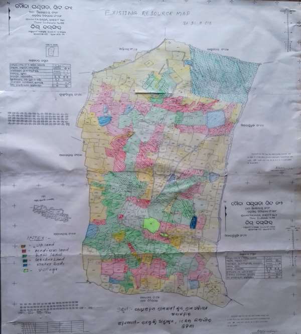
Table of Contents
1.     Background ............................................................................................................... 3
     1.1.    MGNREGS implementation in Odisha and role of ICRG ........................................ 3
     1.2.    Need for demonstration of model villages under MGNREGS ................................ 4
     1.3.    Key approaches .................................................................................................. 5

2.     Model Village Plan of Ghantasada Village ........................ Error! Bookmark not defined.
     3.1.    Topography and climate of Titilagarh Block ............... Error! Bookmark not defined.
     3.2.    Rainfall ..................................................................... Error! Bookmark not defined.
     3.3.    About the Village ...................................................... Error! Bookmark not defined.
     3.4.    Key Issues in Ghantasada Village ............................... Error! Bookmark not defined.
     3.5.    Key Reasons for taking- up Model Village Programme under MGNREGA....... Error!
     Bookmark not defined.
     3.6.    Process followed for preparation of Model Village Plan ..................................... 10
     3.7.    Demographic Details of the Village............................ Error! Bookmark not defined.
     3.8.    Vulnerability ranking of Ghantasada Village ............. Error! Bookmark not defined.
     3.9.    Land, Agriculture and Irrigation Profile of the Village Error! Bookmark not defined.
     3.10.      Action Plan of Ghantasada Model Village .............. Error! Bookmark not defined.

4.     Approval & Execution of Works ............................................................................... 23

5.     Exist Strategy ........................................................................................................... 23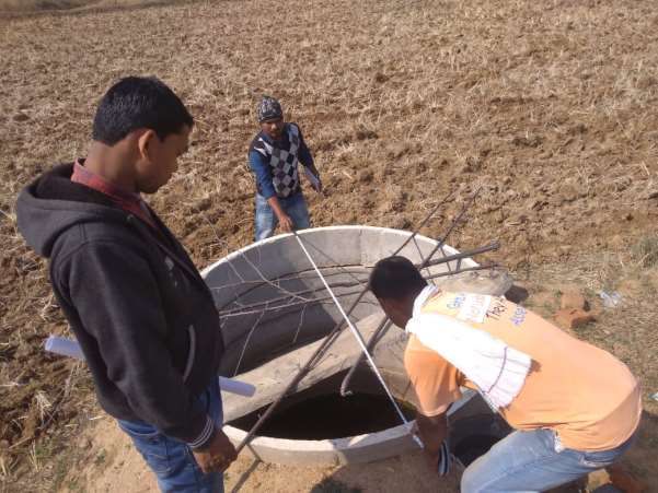
1. Background
Agriculture in Odisha is the mainstay of majority of the populace and thus, holds the key to
socio-economic development of the State. The State has cultivated area of 61.80 lakh
hectares out of which 29.14 lakh hectares is high land, 17.55 lakh hectares medium land and
15.11 lakh hectares low land. The State is broadly divided in to 4 Physiographic zones those
are further subdivided into 10 agro-climatic zones. Further, about 4 lakh hectares is exposed
to saline inundation, 3.54 lakh hectares to flooding and 0.75 lakh hectares to water-logging,
particularly in the deltaic areas. With more than 2/3rd of crops grown rainfed, a good
harvest is much dependent on a favourable monsoon.

The climate of the state is tropical, characterised by high temperature, high humidity,
medium to high rainfall and short and mild winters. The normal rainfall of the State is
1451.2 mm. The actual rainfall received, vary from district to district. About 84% of rainfall is
received during the period from June to September. Even though the quantum of rainfall is
quite high, its distribution during the monsoon period is highly uneven and erratic. As a
result, flood, drought and cyclone visit regularly with varying intensity. The frequent
occurrence of these natural calamities badly affects the production of kharif rice, the major
crop of the State. Similarly, in drought years, there is considerable loss in production of
pulses and oilseeds both during kharif and rabi(Source: Drought Management plan of
Odisha 2015, Deptt. Of Agriculture, Govt. of Odisha)

   1.1.    MGNREGS implementation in Odisha and role of ICRG
In a state like Odisha, effective implementation of MGNREGS is the key to balance the
degraded ecosystem in the rural areas and enhance the livelihoods security of rural
population.
Progress parameters          FY 2018-2019   FY 2017-2018   FY 2016-2017   FY 2015-2016
Approved Labour Budget[In               950            900            800         760.06
Lakhs]
Persondays Generated so                611.5           922.17           774.48            894.46
far[In Lakhs]
Women Persondays out of                 42.1            41.86             39.82            38.02
Total (%)
Average days of                        33.09            39.98             38.09            44.78
employment provided per
Household
Differently abled persons              7262              9329             6303              5586
worked
% of Expenditure on                    64.53            71.34             65.92            52.29
Agriculture & Agriculture
Allied Works
Total Exp(Rs. in Lakhs.)         1,63,694.67      2,50,479.89       2,13,572.78      2,05,148.18
The state has been able to spend about Rs 2500 crore for creating persondays of about 922
lakh as of last financial year. The %age of expenditure in agriculture and allied activities has
been increasing and it was 71% in last FY. Differently abled people are also getting more and
more engagement under the scheme.
Infrastructure for Climate Resilient Growth Programme (ICRG) is being implemented in 35
Blocks of 5 districts of Odisha (Mayurbhanj, Keonjhar, Balangir, Kalahandi and Nuapada).
Later on 11 more Blocks and one new district (Bargarh) have been added in the programme.
Demonstration of Climate Resilient Works (CRWs) through integrated approach is the key
focus under ICRG in Odisha. The programme builds the capacity of administrative and
technical staff at different level to take up climate change specific plans under MGNREGS
and incorporate the climate resilient designs in the MGNREGS works. While demonstrating
the CRWs leveraging resource from other schemes and programmes is also the priority for
the programme.

   1.2.    Need for demonstration of model villages under MGNREGS
Though the concept of model Gram Panchayat (GP) has been conceived since the inception
of the ICRG programme in Odisha, Model Village Programme has been prepared based on
net planning approach to saturate MGNREGA works in the vIllage taking consideration of
water availability ( both supply and demand) , historical rainfall pattern and future
projection.. At the pilot stage, 2 villages are taken to make them model villages. The idea is
to saturate the MGNREGS works in the villages so that maximum resource can be effectively
utilised. Series of discussions have been made with PRIs, Block officials and CSOs before
finalizing the Gram Panchayats/villages for demonstration purpose. Following criteria have
been followed for selection process of Model Villages.

   •   Vibrant Gram Panchayats– Because of the financial and functional strength of a
       Panchayat is extremely useful in preparing need based plans, executing the plans in a
       time-bound manner, vibrant and strong GPs are considered for showcasing results.
       The governance system of the GPs and the capacity of PRIs were studied in detail for
       selecting the GPs.
   •   Potential for piloting new initiatives – Introducing innovations are the key for
       demonstrating the impact for which the GP has to offer avenues for experimenting
       with new initiatives. Hence it is important that the GP officials and the institution
       leaders must be in a position to move out of their comfort zone and accept the
       concept of change while introducing innovations.
   •   MGNREGS Potential in the GP- Because MGNREGS is the platform for implementing
       ICRG and the base for leveraging resources from other schemes for synergy, it must
       be effectively implemented in the GP. Right kind of plan, timely execution of works,
       proper monitoring system in place, active role of PRIs, need based works in place are
       some of the parameters taken up to ensure effective implementation of MGNREGS
       in the GP.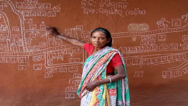
• High potential GP- The GP must come under the high potential category meaning
that the scope of fund absorption must be very high from different schemes,
presence of diverse groups, availability of natural resources and focus of the local
administration. This must invite implementation of schemes like, ITDA, WADI, NRLM,
PMKSY, IWMP etc.
• Presence of historically marginalized groups- Across the State the poor access of
vulnerable groups to MGNREGS and other flagship schemes has been an issue. At the
same time climate change projection reports that these groups are likely to be highly
impacted by climate change in future. Hence their presence in the GPs are
considered as well for selection.
• Geographical coverage- While selecting the GPs the sensitivity of the blocks and
panchayats to climatic change was considered based on the climate modelling study
report, Vulnerability assessment reports etc. Hilly and plain terrains were also taken
into consideration for selection of GPs/villages.
1.3. Key approaches and planning process followed during Model Village
Net planning preparation in Ghantasada Village of Titilagarh Block,Balangir district,
Odisha.
ICRG Team facilitated preparation of Model Village Plan through participatory and technical
approach involving all sections of the village, Gram Panchayat Sarpanch, Gram Rojgar Sevak
(GRS) , PRI member, Village Mate, Women SHG leaders etc. Following key strategies were
followed for preparing the model village plans in both the villages.
• Household level Baseline Data Collection
• Collection of Cadastral Map from Tehsil Office
• RoR download from Bhulekh Portal
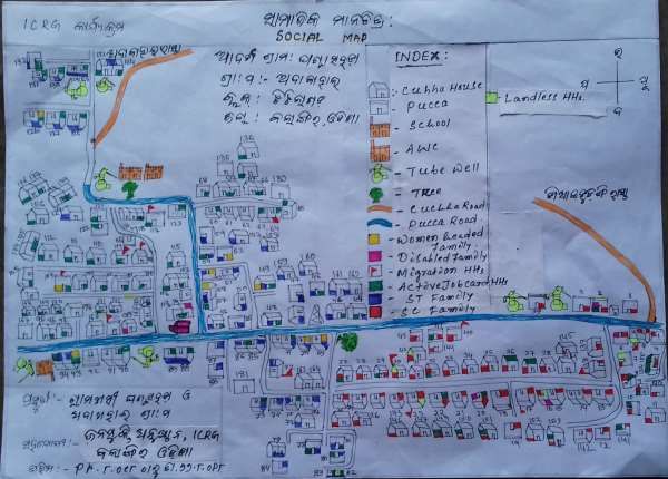
• Social Mapping with villagers
• Well Being Ranking of all Households (WBR) based on present living standard of
communities and ranking them in-to 4 categories ( Well-off, Manageable, Poor and
Very Poor ) as per the indicators and icons fixed by the villagers.
• Focused Group Discussion (FGD) on various issues related to MGNREGA Assets and
Potential NRM Works , Drought Occurrence, Agriculture Productivity, Cropping
Pattern , Migration, Livelihoods of Vulnerable Communities, Livestock , Irrigation
and Ground Water Status , Women Institutions (SHGs) , Drinking Water Scarcity etc.
• Identification and Mapping of Existing Assets , Forest cover and Pasture land.
• Transact walk to various patches , assets, Water Harvesting Structures, Barren land
etc. to understand the existing water table and availability , soil texture , cropping
pattern
• Identification of NRM works proposed , Plot Numbers, Beneficiary and marking in
the treatment map with different intervention icons.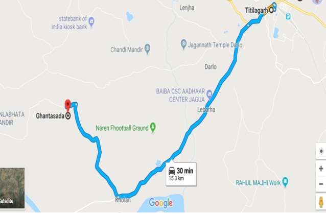
•   Plot wise Net Planning of NRM and Livelihood Assets (Community and Individual
    Assets) with various categories of Households under MGNREGA and other schemes.
•   Preparation of Agriculture based livelihood interventions integrating the Water
    structures (Existing and Proposed) for doubling income of farmers with innovation
    on agriculture.

•   Preparation of Off-farm livelihood plan with the poorest communities for enhancing
    their income.
•   Preparation of Institution and Capacity Building Plan of Model Village and promotion
    of Farmers’ Producer Organization.
•   Analysis of active card holders, person-days , completion of works at GP level
•   Preparation of Present and Proposed Treatment Map with plot wise planning.
•   Water Budgeting (Measurement in existing water bodies, capacity calculation for
    current and future water bodies, present water supply and water demand and future
    requirements)
•   Preparation of broad prospective Action Plan on saturation approach under
    MGNREGA and Budgeting of activities /NRM works.
•   Sharing and approval of action plan with the village communities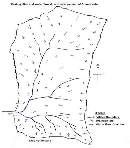
Criteria suggested by Villagers for Well Being Ranking of Households

Category     of Indicators suggested by Villagers as per present well-being
Well Being

Very Poor             •   Mostly households having low income and take credit foe managing their
                          livelihoods for more than 6 months in a year .
                      •   Women headed households
                      •   Asset less Households
                      •   Single Women headed households with no dependent to support them
                      •   Distress Migrant households
                      •   Household who need Support of others for their survival.

Poor                  •   Wage Earners who a take credit to manage their livelihoods for 3-4
                          months in a year.
                      •   Migrate to other places for earning their income
                      •   Small land holders and farmers
                      •   Kuchha house ( other than IAY houses)

Manageable            •   Earn income from various sources (Agriculture, Livestock and service
                          sector) and does not take credit for managing basic livelihoods
                          throughout the year.
                      •   Children go to education up-to 10th standard and more
                      •   Pucca/ Semi-Pucca houses ( Other than IAY)

Well Off              •   Manage livelihood of family throughout the year without taking credit.
                      •   Having Surplus income and gives credit to others
                      •   Mostly regular salaried, Big Farmer , Good earning through business
                      •   Good Health condition
                      •   Having Pucca house

Titilagarh Block Profile :
Titlagharh is one of the 14 Blocks of Balangir District in Odisha which has 22-gram
panchayats, 133 villages and a total of 30,879 households. Titilagarh Block of Balangir
District is known for continuous dry spell, drought and temperature during summer raises
up-to 48 °C. According to the 2011 census, the total population of the block is 1,18,942 out
of which the percentage of SC population is 19 % and ST population is 20 %. The percentage
of vulnerability households of this block is 41.61 %which includes women headed
households, differently able small marginal farmers and migrants.

The study undertaken by Indian Institute of Science (IISc) Bengaluru under ICRG programme
to understand the climate change scenario of the block is mentioned in the table.
1.4. About Ghantasada Village
Ghantasada Village under Adabahal Gram Panchayat of Titilagarh Block in Balangir District is
about 10 KMs away from Block HQ and
Ghantasada Village at a Glance
it is 68 Kms away from District HQ
Name of the Village: Ghantasada
Balangir in Odisha. It comes under
Name of the GP: Adabahal
Western Central Table Agro-climatic
Name of the Block: Titilagarh
Zone in Odisha. The Village has 182
Name of the District: Balangir
households and a total population of
Distance from Block HQ : 10 KMs
729. Agriculture, Wage Employment
Total Nos of HHs: 182
and Livestock rearing (Small
Total Nos. of ST HHs: 65
Ruminants) are the key source of
Total Nos of SC HHs: 60
income of the Villagers. About 70% of
the households of the village belong to Total Population: 729
SC & ST Category. There are 120 active Male Population: 377
job card holders in the village and Female Population: 352
MGNREGA has been implemented in this village since 2008.
1.5. Climate of Ghantasada (as per block level data)
The study undertaken by Indian Institute of Science (IISc) Bengaluru under ICRG programme
to understand the climate
Historical (1984-2014)
change scenario of the block is Historical mean maximum temperature 37°C
mentioned in the table. Highest temperature recorded 45°C
Change in mean maximum temperature 0.36°C
The climate of Bolangir District
Mean JJAS rainfall in mm 1229
especially Titilagarh Block is
Coefficient of variation (CV) in % 32.6
characterized by a very hot dry Total number of rainy days for 30 years 2491
summer and highly erratic Average number of rainy days/year 83
distribution of South West Number of years with normal sowing rains 4
monsoon rains. Temperature Number of years with abnormal sowing 26
mainly stretching from April to rainfall
June and the maximum Number of years with mild drought condition 10
temperature is 49 Degree C. The Projected (2021-2050)
wind speed in the area is very Change in temperature relative to historical by 0.88°C
2035
slow and the project area comes
Mean JJAS rainfall in mm 1180
under ‘West Central Table Land’ Coefficient of variation (CV) in % 33.2
agro-climatic zone characterized Total number of rainy days 2687
by hot and sub-humid climate. Average number of rainy days/year 90
Though the predicted data said % increase in number in rainy days 7.3
that the number of rainy days is going to increase form 83 days to 90 days, However the
average JJAS rainfall if going to decrease in future from 1229 to 1180 mm.1.6. Topography of Ghantasada:
The village is surrounded by Shiyalsukuri village in East side, Adabahal and Dungriguda in
west side, Makripada and Khandapadar in north side and Gandargada village in south side.
In the south side Gandargada village ends with the foot hill of a large stone. The boundary of
the Ghantasada village starts at the foothill. Runoff of one side of that hill flows to
Ghantasada village from south to north. The village has moderate undulating topography
with three types of land- Upland, Ghantasada: Land use details
medium and low land. Except from Total Geographical Area: 314 Ha
south side, no runoff water flows from Forest area 5.4 ha
other villages into Ghantasada village. Area under non agricultural use 53.68 ha
Thus the upland of Ghantasada itself Barren and Uncultivable land 8.05 ha
contributed water to medium and low area
land and also acts as ridge line of Permanent pasture & other 5.16 ha
watershed. There is a single point at grazing land area
the west south side that further drains Cultivable waste land 4.7 ha
the excess runoff water of the Net sown area 236.99 ha
Ghantasada village to Adabahal village.
Longitude: 83.0662515 E
Except a large patch in the north of
Latitude: 20.2603402 N
village reserved for Pasture land else
*Source: SECC 2011
most of the upland patches are
cultivable land and thus slight erosion found in the pasture land only.
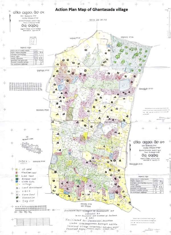
Location Map of Ghantasada Village, Titilagarh Block.1.7. Key issues in the Village As per the discussion with the villagers of Ghantasada Village during PRA exercises, following key issues were emerged. • Regular dry spells and drought leading to damage of Kharif Crop in alternative years. • Low Crop Productivity • Lack of Assured Irrigation Facilities • Limited scope for Rabi Crop • Limited Number of Water Bodies to harvest rain water • Ground Water level is drying up • Availability of Barren & Waste Land and opportunity for treatment • Issues of Un-employment and distress migration • 80% Households are under Poor and Vulnerable Category as per Well Being Ranking. • Potential for Vegetable cultivation during Kharif . 1.8. Process followed for preparation of Model Village Plan ICRG team facilitated preparation of model village action plan in the village with the participation of community, SHGs members, PRIs members and MGNREGS functionaries. Action plan map is one of the important map as from the map we can avail the information plot wise where the structures to be constructed & necessary treatment to be done. At first the boundary of Ghantasada village is identified. Before making the action plan map the villagers are directed to involve in social mapping of their village. They made it by providing all information about the 180 HHs of Ghantasada. They have identified the ST, OBC, Vulnerable HHs like woman headed which is very essential for planning process. The villagers converted the cadastral map in to resource map indication the up land, low land, medium land, barren land, forest cover, water bodies in to different colours. The villagers are mobilized & identified their individual plot with accuracy & precision and existing resources in their plot. From the Google map using software & merging the plot wise ROR in Google map we get to know about the drainage line & water flow line, barren patch, low land, up land, forest cover etc plot wise & beneficiaries wise details in full accuracy. The need & demand of villagers along with the available suitability of location to carry out rain water management works, plantation, primary bund, check dam, farm pond were identified and marked in the cadastral map. Moreover, the cadastral map is converted to action plan map by showing different essential works to be done with different colours in the map. Processes followed for preparation of plan steps wise are as below:
1.9.     Demographic profile of the village

                      Caste Wise Distribution of Population of Ghantasada Village

   Caste          No. of HHs           Male               Female                    Total
    Gen               1                  2                   2                       4
    SC               60                 129                126                      255
    ST               65                 118                116                      234
    OBC              54                 128                108                      236
   Total             180                377                352                      729

   1.10. Well Being Ranking of the Village
                 Category wise Well Being of HHs in Ghantasada Village.
  Very Poor and        Poor HHs       Manageable HHs       Well Off HHs                   Total HHs
  Vulnerable HHs
           47                  110                   21                       2             180

Social map of the village Ghantasada
During this exercise, it is also found that there are 7 disable HHs and also one special SHG
for disable members exist in the village. There are 12 women headed HHs out of those one
HH belongs to SC category, 9 are from ST and 2 are from OBC category.
1.11. Land holding details /land type and existing resources of Ghantasada village
Sl. No. Land Details Nos. of plots (Area in Ha.)
1 Total Geographical Area 958 314 ha
2 Up land 344 161.4
3 Medium land 210 84.8 ha
4 Low land 132 67.2
5 Other (forest, HHs area, 272 21.2
pond, road, pasture etc)
• Source: Bhulekh, Odisha
Land type and resource map of the village Ghantasada:In the above map, the plots with yellow colour and shaded are upland, red with shaded are
medium land green with shaded are low land. Light green with shaded and tree symbol in
the north east corner plots are forest, pasture and other fallow land. This patch is fully for
the use of community and marked as community land. The radium coloured part is the
habitat area where the villagers are living. There is another small habitat area found in the
village and that has been built in last 20 years period and not reflected in the revenue map.
The blue coloured are water bodies mainly ponds, earthen embankment, tank etc. The
village does not have any stream. The low land plots are served as drainage line of the
village. Most of the water bodies are situated in the medium land or in the transition of
either up-medium or medium low land. There are total of 13 large and small size water
bodies found in the village. Black coloured circle are dug wells. The village has potential to
explore ground water through dug well as water found in lowest depth in low and medium
land , however the village has only 10 existing dug wells. Out of 10, there 4 masonry wall
dug wells, 4 ring wells and 2 kuchha well without any ring or masonry wall. During transact
walk and interacting with community it is found that except the extreme south part of the
village rest part are suitable to dug ring type well as soil depth is high and some existing well
ring wells are found working and irrigating vegetable crops almost 4 ha of area during Rabi
season. The village though have some bore wells but villagers said that they have tried
digging bore well and gone up 350 to 400 ft depth but they did not get success in digging
bore well and thus there is no functional bore well found in the village.
The village Ghantasada has total geographical area of 314 ha consisting of 958 plots as per
Bhulekh, Odisha (last updated in 1975-76). More than 50 percent (actual 51.4%) land area is
consider as upland area and mostly cotton, Arhar, cotton+ Arhar along with some other
pulses and oilseeds and few plots with upland paddy are the upland crops in the village.
Among this crop cotton is the highest grown crop using ridge and furrow method. Medium
lands are mostly covered with paddy but in many medium land plots cotton and arhar are
also found during transect walk. Total medium land percentage is 27%. Though the total
lowland plot numbers are lower than the medium land plots, however as per cadastral map
low land plots are in larger size and hence its share is 21.4 percent of total land area of the
village. But the present scenario the number of low land plots are high as many lots are
divided now and also umbers of ownership has increase since last 40-45 years. These low
lands are mostly paddy grown area with good fertile soil and mostly ensure the food
security f the village HHs if there is a good and normal rainfall year. The village has almost
6.75% of land area with total 272 plots for Gharabari (Habitat) area, pond, forest, pasture
land, road, and other uses. Following map is depicted the above description well.
1.12. Drainage map of Ghantasada:
As mentioned earlier, Ghantasada village is surrounded by its up land that worked as ridge line in
almost all side of the village except in south side where there is a large stone hill situated and fall in
another revenue village. So, except south side the ridge line fall in another village, otherwise the
ridge line of all three side falls in the village either due to upland, or due to the village approach
roads. The runoff of whole village passes from upland to medium land and then to low land and
flows out from village in the west side to Adabahal village clearly shown in the drainage map below.
Hence the entire village falls in a single micro watershed. In fact the boundary of the microwatershed also falls to other village in the south side. Hence the village has huge potential to catch
rainfall water in its upland and medium land following ride to valley approaches as the villagers need
to depend on other village where a watershed ridge fall in two or more villages. The villagers can
also allow water to recharge or percolate down in their upland to solve the issue of drought or
moisture stress in the medium and low land as the harvested water and subsurface flow for their
upland will only flow to their low as per principle of surface and subsurface flow for shallow water
bearing strata.
1.13. Slope map of Ghantasada
Though the village having undulating topography, however the undulation is not high and
haphazard, that make the villagers difficult to cultivate their land. As found in the drainage map and
land type, the village organization of cultivable and other plots are situated in such a way that entire
land of the village are distributed in three different terrace- those are up, medium and low. In each
terrace the slope individual plots are not that high. The altitude differences form one terrace (up t
medium and medium to low) to another may be more than a meter, but within a terrace the slope of
plots are moderate except in few patches. During transect walk in it is fund that in south side the
slope of upland plots are high and also not treated hence some gullied found there as huge runoff
water flows from the stone hill. Similarly in the north side in north east corner there is community
pasture and other common land that too have little higher slope and thus slight soil erosion traces in
that patch. During field transaction it is observed that the village having 10-15 ha area with 3-5%
slope in the south side, 20-30 ha area with 2-3% slope in the north side, more than 175 ha falls in 1-
2% and rest (almost all low land and some medium land) falls in 0-1% slope.1.14. Water Budgeting of Ghantasada (water demand and supply assessment) :
To compute the water demand and supply, water budget calculation template developed during the
Saksham training of MGNREGA was used. The major finding of the water budget assessment is
represented in the table below.
Total water for agriculture requirement has been calculated as 89.8 ha-m and water for animal and
human has been calculated as 1.42 Ha.m. Total water requirement has been calculated as 91.2
Ha.m. The available runoff from the area is 124.6 Ha.m. The water deficiency to address the
requirement is 76.1 Ha.m. Based in the available discharge of 109.6 Ha.m, maximum of 82.2 ha-m
can be harvested to meet the requirement and it is more than calculated deficit.
D.1: Drinking water requirement
Daily (Litres)
(source: Water Required
Description Number
SAMARTHYA) (Daily)
Human 729 45 32805
Large Ruminant (Animals) 148 35 5180
Small Ruminant 115 8 920
Poultry-Birds 350 0.25 87.5
38992.5
Total
Water Required Annually (Cum) (D10*365/1000) 14232.26
Water Required Annually (Ha.M) 1.42
D.2: Crop water requirement
require Present Supply additional
Area d per from Requiremen
Water
Crop (Hect. (Ha-M) groundwate t
Requiremen
) r
t (Ha.M)
Mung 3.2 0.2 0.6 0.0 0.6
Black gram 2.8 0.2 0.6 0.0 0.6
Horse Gram 2 0.2 0.4 0.0 0.4
Khari Cotton 48 0.45 21.6 21.6
f Cotton + Arhar 22 0.45 9.9 0.0 9.9
Arhar 18 0.4 7.2 0.0 7.2
Paddy 112 0.4 44.8 0.0 44.8
Total 208 85.1 85.1
Vegetable 11.6 0.45 5.2 1.8 3.4
Rabi Black gram 1.6 0.45 0.7 0.0 0.7
Horse Gram 1.2 0.45 0.5 0.0 0.56.5 4.7
Total crop water
requirement 89.8
Note: Highlighted supply of GW is from 5 functional dug wells. The kharif water requirement for
paddy, cotton and arhar has been considered only for dry spell and after rainy season i.e. life saving
during rainy season and post rainy season irrigation for cotton and arhar.
D.3 Details of slope:
Slope Topography Area
0 - 1% Low lands (Farm lands) & few medium land plots 100
1-2% medium and few upland plots (Pastures & Open Area) 175
3- 5% Foot hill upland (Pastures & Open Area) 39
Above 5
Upper reaches & Forest area 0
%
Total 314
D.4: Amount of Runoff
Rainfall:1219.2
Amount of runoff (To be calculated from Strange’s table method)
mm
Area % of run-off
Types of Run-Off run-off (Ha.M)
(Hect.) Runoff (Cum)
Good Run-off Area 39 46.5 5669.28 22.1
Average Run-off Area 175 34.8 4242.816 74.2
Bad Run-off Area 100 23.2 2828.544 28.3
Total 314 124.6
Note: JJAS mean average rainfall of Titlagarh is 1229 mm.
D.5: Stored water in harvesting structures
Existing Structures
S.N. Name of Structure Storage Capacity
No./Area in Ha
(Ha.M)
1. Pond (Talab) 15 no's 7.64 15.08
2. Farm Pond 0
3. Anicut 0
4. CCT (Area in Ha.) 0
5. MPT 0
6. SGPT 0.0000
Total 15.08D.6: Ghantasada village water budget:
Volume
S.N. Name of Village
(Ha.M)
1 Water for Agriculture (Table D.2) 89.8
2 Water for Animal & Human (Table D-1) 1.42
3 Total water required (D1+D2) 91.2
4 Available run-off from rain water (Table D.4) 124.6
5 Harvested Runoff from Water Harvesting Activities (D.5) 15.1
6 Water deficiency/Surplus (5-3) -76.1
Water can/to be harvested to meet up the requirement (75
7 % of available run-off -harvested run-off) (D77*75/100- 82.2
D78)
8 Available discharge water at exit (4-5) 109.6
1.15. Action plan of Ghantasada village:
The action plan has been developed on basis of the aim to enhance productivity in agriculture and
thus doubling the farmer’s income. As there are various category of HHs such as women headed,
disable, poor, marginal, landless etc, only lad based activities are not sufficient to plan to enhance
the income of every HHs. Thus along with land based activities through MGNREGA, activities such as
goat, cow, poultry shed etc were planned for landless and low land holding HHs. Similarly other non
land base livelihood activities are also discussed with SHG women, mapped their skills and then with
the consensus of SHG women, some on farm and off farm livelihoods activities are also planned and
proposed with the support of other line department. Hence the entire village plan is categories in
the following two parts:
1.15.1: MGNREGA work Plan
Looking the issues of the village after PRA exercise including transact walk, there are 8 different
types of NRM work has been identified for the village Ghantasada to increase the irrigated area and
enhance the agricultural productivity of the village. These activities are taken in integration so that
the efficacy and durability of each asset can be assured. In the pasture land, plantation has been
proposed with integration of 30x40 models, so that plant survival rate can increase and ensure soil
moisture during dry spell and to promote better growth of the plant. LBCDs are taken the catchment
of water harvesting structures and also in the catchment of land development area. Dug wells are
proposed mostly in the downstream plots of different types of water harvesting structure to tap the
subsurface flow from those renovated water harvesting structures. In some water harvesting
structures fisheries are already going on and it was found that community is more interested to do
fish cultivation in all village pond through SHGs or through contract basis. Farm ponds are mostly
proposed in the land development area or in medium land where upland are proposed for land
development activities through field bunds. Non NRM work such as cow, shed, goat shed and
poultry shed are also taken as livelihoods enhancement to create alternative livelihoods in the
village and also to support agricultural production. These non NRM activities further integrated with
construction of compost pits to produce compost manure in the village using cow dung, goat dungand poultry waste. These will further help the villager to keep village clean by managing solid waste and also would enhance soil fertility and thus would increase farm productivity. The proposed NRM activities are shown in the action plan map below and also budgeted in the table below:
Budget Summary of Ghantasada village:

Sl   Activity           Area in Nos. of beneficiaries         No      Material   Labour     Amount
no                      ha                                    of      Cost       cost       (Rs.)
                                                              Plant
       A. NRM Activities
1    30x40     model 10.77         Community land             2000    530000     1090187    1620187
     with     Cashew
     Plantation
2    LBCDs           6             Community land and                    59414      46231     105646
                                   individual land of6
                                   farmers
3    Earthe     Bunds 47.10        Individual land of 70                179370    3587403    3766774
     (type-1&2,                    HHs
     CS=0.7 and 0.94
     sq.m)
4    Dug wells (RCC 14.91          Individual HHs for 25                765000     409369    1174369
     ring type)                    HHs
5    Farm       ponds 11.88        Individual HHs for 26                554320    2695680    3250000
     (12x15x3) cum                 HHs
6    WHS (earthen 1.74             in Community land, HHs               211212    4224247    4435460
     embankment                    benefited=32
     types) 4 nos.
7    Renovation       0.41         in community and 1                    51760    1035194    1086953
     Tank, 3 nos.                  individual HHs land, HHS
                                   benefited 12
8    Renovation    of 1.90         in community land, HHs              1700000    2428756    4128756
     Pond 3 nos.                   benefited= 40
                Sub Total A: NRM Activities                            4051077   15517067   19568144
                  B. Non NRM Activities
1    Cow shed                      12 HHs                              1017000     339000    1356000
2    Poultry Shed                 7 HHs                                 204750      68250     273000
3    Goat Shed                    7 Hhs                                 231000      77000     308000
4    Compost pits                 30 HHs                                315000     105000     420000
              Sub total B: Non NRM Activities                          1767750     589250    2357000
     Total                                                    2000     5818827 16106317     21925144
                Note               No of plant                2000 Nos.
                                   Material Cost                       5818827   27%
                                   Labour Cost                        16106317   73%
                                                                      2192514
                                   Total MGNREGA budget               4
                                   Person day generated               88496
1.15.2: Livelihoods and convergence plan: Gantasada village faces regular drought and dry spell during Kharif season due to erratic and scanty rainfall in the Adabahal Gram Panchayat of Titilagarh Block. Paddy is the main crop of the farmers during Kharif season growing in about 70 Ha. Besides, the farmers grow Cotton inter cropping with Arhar in 38 Ha, only Arhar in 10 Ha, other pulses in 8 Ha ( Green, Black and Horse Gram) and grow vegetable in 4 Ha, during Rabi . 10 Nos of SHGs with 106 members are active in the model Village. Other Off- farm activities in the village are goat rearing, ship rearing , poultry etc. The Village is having issues of both water scarcity and underutilization of available water . Kharif Paddy crop is affected by dry spells in up and medium land and the available water resources in the existing dug wells are not fully utilized by farmers during Rabi crop due to various reasons. So there is potential for promotion of Rabi Crop like Mustard, Sunflower, Potato, Onion , Vegetables linking existing water bodies ( Dug Wells, Ponds etc) which may help some farmers doubling their income. Dedicated Human Resource Support is required for mobilization of communities, farmers , market linkage , convergence etc with line departments and making things happen to improve cropping intensity thereby enhancing income. The Livelihood Plan has been prepared after transact walk to all patches in the village area, discussion with Villagers, SHG members on present cropping pattern, potential areas of intervention in the farm, non-farm and off-farm sectors based on water availability, market potential, skill of farmers, local climate scenario and taking demand from various sections of the society like Women SHGs, Farmers, Vulnerable Households. Convergence with other line departments like Agriculture , Horticulture , Animal Resources OAIC, Odisha Livelihood Mission etc has been mapped for implementation of livelihood plan . As per need, Framers’ Producer Organization (FPO) may be formed for backward and forward linkage of the farm and improving non-farm production system to ensure better price . Further, better package of practices (PoPs) in in the farm sector with existing and future climate prospective has been planned to be introduced in Paddy, Pulses, vegetable and other horticulture crops ( introduction of Organic farming, climate resilient seed varieties in paddy, water saving technology , improved method of production like SCI/SRI , Integrated Pest Management and Integrated Nutrition Management practices , Soil health management etc. ) through Farmers Field Schools (FFS) . Fishery activities may be promoted in the existing water bodies where there is availability of water throughout the year . Regular vaccination of small ruminants, breed improvement in goatery has been planned in the model village. Poultry units has been proposed for improving nutrition supplements and enhancing income, mushroom farming, goat rearing, infrastructure support for value addition of agriculture produce and off-farm activities have been proposed by the SHG members. Regular capacity building of the communities and strengthening of Village Institutions are also highly required for better implementation of model village plan . The Villagers have also proposed Individual Assets under MGNREGA ( Dug well, Farm Pond , Goat shed, Poultry shed etc. ) for improving their livelihoods. The details of Off and On-farm action plan is annexed in the model village plan document. The proposed activities will lead to doubling income of farmers.
Livelihood Plan of Ghantasada Model Village, Balangir
     a. List of proposed On Farm activities through SHGs:

Sl      Activities               Units    Unit cost    Amount     Nos.      of Convergenc
no                                                                beneficiari e
                                                                  es           Departmen
                                                                               t
1       Goat Rearing             450      5000         2250 000   45           Department
                                                                               of    Animal
                                                                               Husbandry
2.      Poultry framing (with 07          40000        280000     07           Department
        20 chicks in each Shed)                                                of Animal
                                                                               Husbandry
3.      Cow rearing        (high 22       40000        880000     11           Department
        breed)                                                                 of Animal
                                                                               Husbandry
4       Sheep Rearing            60       4000         240000     6            Department
                                                                               of    Animal
                                                                               Husbandry
5       Cotton Cultivation       31.5     4000         126000     45           Department
                                 Acre                                          of Textile
6       Vegetable farming        21       5000         105000     11           Department
                                 acre                                          of
                                                                               Horticulture
7       Introduction          of 10       500          5000       10           Department
        drought        resilient Acre                                          of
        Paddy varieties                                                        Agriculture
        Total                                          3886000    135

     b. List of proposed Off Farm activities through SHGs:

Sl no   Activities              Units    Unit         Amount    Nos.     of Convergence
                                         cost                   beneficiari Department
                                                                es
1       Grocery Shop            03       20000        60000     03          Dept of PR & DW
                                                                            (OLM)/        Dist
                                                                            Industries Center
2.      Tailoring      Machine 03        5000         15000     03          Dept of PR & DW
        and shop                                                            (OLM) )/ Dist
                                                                            Industries Center
3.      Plate            making 01       50000        50000     01          Dept of PR & DW
        machine                                                             (OLM) )/ Dist
                                                                            Industries Center
4       Grocery shop            01       50000        50000     01          Dept of PR & DW
                                                                            (OLM) )/ Dist
                                                                            Industries Center
5        Internet Cafe          01       50000        50000     01          Dept of PR & DW
                                                                            (OLM) )/ Dist
                                                                            Industries Center
Total 225000 09
c. Proposed Income activities planned for the Physically Challenged person
Name of the member Proposed Income Generation Activity Name of SHG
Anjana Mahananda Tailoring Shop Maa Bhairabi SHG
Manju Banchhor Cow rearing
Mamata Bagarty Goat Rearing
Tanu Rana Vegetable cultivation Maa Tarini SHG
Subhadra Chhura Goat Rearing
Deepak Chhura Vegetable cultivation
Dhanurjaya Herna Cow rearing
1.16. Labour availability analysis and phasing of proposed MGNREGA works
The Ghantasada village having 230 job card holders and approximately 669 people registered as
workers. Among these registered worker there approximately 332 women workers under MGNREGA
to work. However, it is found that there are approximately 97, say 100, active job card holder exist in
the village to participate in MGNRGA works to be carried out in the village as part of model village
planning.
As per labour budgeting process, under MGNREGA, total village budget of a village is =Active job
card holder x 100 person days x daily wages under MGNREGA. This is equal to 60 percent of total
work budget excluding the Administrative charges. Considering this formula and 100 working days
per HHs for 100 active job card holders with a present daily MGNREGA wage rate of Rs. 182, the
total one year works budget for the village is 30.33 lakh. Considering, 80% of this budget can be
spent on NRM works ( if GP and block provide maximum emphasis on NRM works) then Rs. 24,26
lakh, say 25 lakh can be spent in year on NRM work. As the total budget of the proposed MGNREGA
work in the village is Rs. 2.19 crore, thus, the entire plan can be implemented in 09 years considering
availability of Budget, timely fund flow and smooth implementation of works.
Phasing of NRM works as per labour availability and yearly budget limitation.
As the plan was developed at the village and with community’s participation, after preparation of
budget, it was discussed with the villagers that almost all activities plan for the village are urgent in
nature in the lenses of climate change, however the village budget limitation does not allow us to
implement all proposed activities in shorter period. Then the issue was discussed thoroughly and
suggestions solution was come out that the villager will increase the active job card holder by
participating in MGNREGA works. By that way they can also increase their annual MGNREGA work
budget. Thus villager considered that they will have 150 active job card holders in near future so
that they can spend an amount f Rs 45.5 lakh in a year under MGNREGA and thus they would try to
implement the whole planed activities in a 5 years period. After then demanded NRM work are
distributed year wise to prepare an implementation plan. The plan is presented below in a table
form so that during implementation this document can guide the implementers. During phasing of
works some other factors are also considered, such as ridge to valley approaches, integration of
activities and works those can bring resilience against drought and floods. In the first year mostly
area treatment works are considered along with border plantation, so that the treatment of thecatchment area of water harvesting structures could be done before start working on new or
renovation of a WHS. Emphasis was also given during distribution of yearly work on biophysical
parameters such as highly eroded area, water logged area etc.
Sl No Proposed activities Amount in Rs. Distribution of budget
Year-1 Year-2 year-3 Yeaar-4 Year-5
30x40 model with
1 Cashew Plantation 1620187 540062 540062 540062 0 0
2 LBCDs 105646 105646 0 0 0 0
Earthen Bunds (type-
1&2, CS=0.7 and 0.94
3 sq.m) 3766774 565016 565016 753355 941693 941693
4 Dug wells (RCC ring type) 1174369 234874 234874 234874 234874 234874
Farm ponds (12x15x3)
5 cum 3250000 750000 625000 500000 625000 750000
WHS (earthen
embankment types) 4 110886
6 nos. 4435460 5 887092 887092 887092 665319
7 Renovation Tank, 3 nos. 1086953 362318 362318 362318 0 0
Renovation of Pond 3 103218 103218
8 nos. 4128756 825751 619313 619313 9 9
1 Cow shed 1356000 0 339000 339000 339000 339000
2 Poultry Shed 273000 0 78000 78000 117000 0
3 Goat Shed 308000 0 88000 88000 132000 0
4 Compost pits 420000 0 154000 84000 182000 0
449253 448601 449084 396307
Total 21925144 2 4492675 4 8 5
2. Approval & Execution of Works
All the works proposed in the Plan will be approved following MGNREGA procedure and CSO
partner of ICRG will facilitate the approval of action plan of model village in the Labor
Budget of the Ghantasada Gram Panchayat of Titlagarh Block with support of Block and
district MGNREGA Team.
3. Exist Strategy
ICRG Programme will mobilize communities and Block Officials for implementation Action
Plan of Model Village for One Year. Facilitate formation of a User Group inside the Model
Village who will be capacities by ICRG CSO Partner for sharing the activities, implementation
and linking them to GP and Block MGNREGA Team for implementation of all proposed
activities after withdrawing of support of ICRG CSO partner in the Village.You can also read