RESIDENTIAL LAND edmonton.ca/assessment - A summary of the methods used by the City of Edmonton in determining the value of residential land ...
←
→
Page content transcription
If your browser does not render page correctly, please read the page content below
2021
ASSESSMENT
METHODOLOGY
RESIDENTIAL LAND

A summary of the methods used by the City of Edmonton in
determining the value of residential land properties in Edmonton
for assessment purposes.

edmonton.ca/assessment
2021 Residential Land
Assessment Methodology Page | 1
Table of Contents
Scope 2
Introduction 2
Mass Appraisal 4
Valuation Model 6
Property Groups 6
Approaches to Value 7
Direct Comparison Approach 7
Zoning 8
Effectize Zoning 8
Factors Affecting Value 10
Location 10
Positive site influences 12
Negative site influences 16
Lot Characteristics 20
Adjustments 20
Sample Assessment Detail Report 24
Methods to Adjust Comparables 25
Quantitative Adjustments 25
Qualitative Analysis 25
References 27
Appendix 28
Zone Chart: Residential 28
Measure Conversion Chart 29
Copyright of this material and content is owned by the City of Edmonton and none of the content and material may be
copied, reproduced, posted or transmitted in any form without the prior written consent of the City of Edmonton, unless
otherwise being used in accordance with Section 299 and 300 of the Municipal Government Act, R
SA 2000, c M-26.
2021 Residential Land
Assessment Methodology Page | 2
Scope
This guide is an aid in explaining how residential land properties are valued for assessment
purposes. The guide is intended as a tool and complements the assessor’s judgment in the valuation
process.
Introduction
Property assessments in the City of Edmonton are prepared in accordance with the requirements of
the Municipal Government Act, R.S.A. 2000, c. M-26, (hereinafter “MGA”) and the Matters Relating to
Assessment and Taxation Regulation, 2018, Alta Reg 203/17, (hereinafter “MRAT”). The MRAT
regulation establishes the valuation standard to be used, defines the procedures to be applied, and
proposes objectives for the quality to be achieved in the preparation of assessments. The legislation
requires the municipality to prepare assessments that represent market value by application of the
mass appraisal process. All assessments are expected to meet quality standards prescribed by the
province in the MRAT regulation.
Property assessments represent:
● an estimate of the value;
● of the fee simple estate in the property;
● as the property existed on December 31, 2020;
● reflecting typical market conditions;
● as if the property had been sold on July 1, 2020;
● on the open market;
● from a willing seller to a willing buyer.
The assessment is a prediction of the value that would result when those specific, defined conditions
are met.
The legislation requires the City of Edmonton to assess the fee simple estate.
“Fee simple interest [is] absolute ownership unencumbered by any other interest or estate…
leased fee interest [is] the ownership interest held by the lessor, which includes the right to
the contract rent specified in the lease plus the reversionary right when the lease expires…
leasehold interest [is] the interest held by the lessee (the tenant or renter) through a lease
conveying the rights of use and occupancy for a stated term under certain conditions.”
Appraisal Institute of Canada, T
he Appraisal of Real Estate Third Canadian Edition,
Vancouver, Canada, 2010, page 6.4
Copyright of this material and content is owned by the City of Edmonton and none of the content and material may be
copied, reproduced, posted or transmitted in any form without the prior written consent of the City of Edmonton, unless
otherwise being used in accordance with Section 299 and 300 of the Municipal Government Act, R
SA 2000, c M-26.2021 Residential Land
Assessment Methodology Page | 3
Both market value and property, along with additional terms are defined in the M
GA and MRAT :
s.284(1)(r) “property” means
(i) a parcel of land
(ii) an improvement, or
(iii) a parcel of land and the improvements to it
MGA .s.284(1)(r)
s.1(k) “regulated property” means
(i) land in respect of which the valuation standard is agricultural use value,
(ii) designated industrial property, or
(iii) machinery and equipment
MRAT s.1(k)
s.9(1) t he valuation standard f or the land and improvements is market value unless
subsection (2)… applies
MRAT s.9(1)
s.1(1)(n) “market value” means the amount that a property, as defined in section 284(1)(r),
might be expected to realize if it is sold on the open market by a willing seller to a willing
buyer
MGA s.1(1)(n)
s.5 An assessment of property based on m arket value
(a) must be prepared using mass appraisal,
(b) must be an estimate of the value of the fee simple estate in the property, and
(c) must reflect typical market conditions for properties similar to that property
MRAT s.5
s.289(2) Each assessment must reflect
(a) the characteristics and physical condition of the property on December 31 of the
year prior to the year in which a tax is imposed
MGA s.289(2)(a)
s.6 Any assessment prepared in accordance with the Act must be an estimate of the value of
a property on J uly 1 of the assessment year
MRAT s.6
s.1(g) “mass appraisal” means the process of preparing assessments for a group of
properties using standard methods and common data and allowing for statistical testing
MRAT s.1(g)
Copyright of this material and content is owned by the City of Edmonton and none of the content and material may be
copied, reproduced, posted or transmitted in any form without the prior written consent of the City of Edmonton, unless
otherwise being used in accordance with Section 299 and 300 of the Municipal Government Act, R
SA 2000, c M-26.2021 Residential Land
Assessment Methodology Page | 4
Mass Appraisal
Mass appraisal is the legislated methodology used by the City of Edmonton for valuing individual
properties, and involves the following process:
● properties are stratified into groups of comparable properties
● common property characteristics are identified for the properties in each group
● a uniform valuation model is created for each property group
31(c) “valuation model” means the representation of the relationship between property
characteristics and their value in the real estate marketplace using a mass appraisal
process
MRAT s.31(c)
The following two quotations indicate how the International Association of Assessing Officers
distinguishes between mass appraisal and single-property appraisal:
“... single-property appraisal is the valuation of a particular property as of a given date: mass
appraisal is the valuation of many properties as of a given date, using standard procedures
and statistical testing.”
“Also, mass appraisal requires standardized procedures across many properties. Thus,
valuation models developed for mass appraisal purposes must represent supply and
demand patterns for groups of properties rather than a single property.”
Property Appraisal and Assessment Administration, pg. 88-89
Copyright of this material and content is owned by the City of Edmonton and none of the content and material may be
copied, reproduced, posted or transmitted in any form without the prior written consent of the City of Edmonton, unless
otherwise being used in accordance with Section 299 and 300 of the Municipal Government Act, R
SA 2000, c M-26.2021 Residential Land
Assessment Methodology Page | 5
For both mass appraisal and single-property appraisal, the process consists of the following stages:
Mass Appraisal Single Appraisal
Mass appraisal is used to The client specifies the nature
determine the assessment of the value to be estimated,
Definition and base for property taxation in this includes: rights to be
Purpose accordance with legislative valued, effective date of
requirements valuation, and any limiting
conditions.
Mass appraisal requires a The extent of data collection is
database of property specific to each assignment
Data Collection characteristics and market and depends on the nature of
information. the client’s requirements.
Mass appraisal is predicated Market analysis includes the
Market Analysis on highest and best use. analysis of highest and best
use
Valuation procedures are Subject property is the focus
predicated on groups of of the valuation. The analysis
Valuation Model comparable properties. of comparable properties is
generally six or less
The testing of acceptable The reliability of the value
analysis and objective criteria estimate is more subjective.
Validation
Acceptability can be judged by
the depth of research and
analysis of comparable sales
Copyright of this material and content is owned by the City of Edmonton and none of the content and material may be
copied, reproduced, posted or transmitted in any form without the prior written consent of the City of Edmonton, unless
otherwise being used in accordance with Section 299 and 300 of the Municipal Government Act, R
SA 2000, c M-26.2021 Residential Land
Assessment Methodology Page | 6
Valuation Model
A valuation model creates an equation of variables, factors and coefficients that explains the
relationship between estimated market value and property characteristics. An assessed value is then
calculated by applying the appropriate valuation model to individual properties within a property
type.
s31 (a) “coefficient” means a number that represents the quantified relationship of each
variable to the assessed value of a property when derived through a mass appraisal
process
(b) “ factor” means a property characteristic that contributes to a value of a property;
(d) “ variable” means a quantitative or qualitative representation of a property
characteristic used in a valuation model
MRAT, s.31 (a), (b) and (d)
s.33 Information prescribed … does not include coefficients
MRAT, s.33(3)
● variables are identified from property characteristics
● statistical analysis determines how variables affect market value
Valuation ● factors and coefficients are determined
Model ● the resulting valuation models are applied to property
characteristics
Property Groups
Residential
Residential properties are the lands and improvements, which are intended or developed to be
self-contained dwelling units having one or more rooms accommodating sitting, sleeping, sanitary
facilities, and a full kitchen.
Residential Land
Residential Land is vacant land zoned for future low density residential uses. This inventory can also
include RF5/RF6 zoned vacant parcels with no multi-residential development potential.
Copyright of this material and content is owned by the City of Edmonton and none of the content and material may be
copied, reproduced, posted or transmitted in any form without the prior written consent of the City of Edmonton, unless
otherwise being used in accordance with Section 299 and 300 of the Municipal Government Act, R
SA 2000, c M-26.2021 Residential Land
Assessment Methodology Page | 7
Approaches to Value
The approaches to determine market value are the direct comparison, income, and cost
approaches.
Direct Typical market value (or some other characteristic) is determined by
referencing comparable sales and other market data. It is often used
Comparison when sufficient sales or market data is available. It may also be referred
Approach to as the Sales Comparison Approach.
This approach considers the typical actions of renters, buyers and sellers
when purchasing income-producing properties. This approach estimates
Income
the typical market value of a property by determining the present value
Approach of the projected income stream. Often used to value rental or leased
property.
Typical market value is calculated by adding the depreciated replacement
Cost cost of the improvements to the estimated value of land. It is often used
Approach for properties under construction or when there is limited market data
available.
Direct Comparison Approach
For this property group, the assessment is determined using the Direct Comparison Approach. It is
the most appropriate method of valuation for Residential Land properties in the City of Edmonton
because it mirrors the actions of buyers and sellers in the marketplace and sufficient residential land
sales data exists in order to derive reliable market estimates.
The income and cost approaches were not used in the valuation of this property group, as these
approaches are more applicable to income producing properties or in limited markets, respectively.
The majority of these properties in this inventory are owner occupied with only a portion of the
inventory traded based on the property’s ability to generate income.
The City of Edmonton validates all land title transactions (sales). The validation process can include
site inspections, interviews with parties involved, a review of land title documents, corporate
searches, third party information.
The City of Edmonton reviews sales occurring from July 1, 2015 to July 1, 2020 in valuing Residential
Land properties. Time adjustments are applied to sale prices to account for any market fluctuations
occurring between the sale date and the legislated valuation date. The City of Edmonton uses the
date the legal title transfer was registered at the Land Titles Office as the sale date of a property.
Sale price reflects the condition of a property on the sale date and may not be equal to the
assessment.
Copyright of this material and content is owned by the City of Edmonton and none of the content and material may be
copied, reproduced, posted or transmitted in any form without the prior written consent of the City of Edmonton, unless
otherwise being used in accordance with Section 299 and 300 of the Municipal Government Act, R
SA 2000, c M-26.2021 Residential Land
Assessment Methodology Page | 8
Zoning
The rules and regulations for land development within Edmonton are contained in the Zoning Bylaw,
No. 12800.
s.6.123 zone: a specific group of listed Uses and Development Regulations which regulate
the Use and Development of land within specific geographic areas of the City...
Zoning Bylaw No. 12800, 2017, s. 6.123
Residential land use zones vary in part due to density.
s.6.24 density: when used in reference to Residential and Residential-Related development,
the number of Dwellings on a Site expressed as Dwelling per hectare.
Zoning Bylaw No. 12800, 2017, s. 6.24
A residential zone summary is in the Appendix.
Effective Zoning
Effective zoning is an internal coding applied to reflect the current use and/or development potential
of a parcel. Effective zoning will generally reflect the actual zoning of a parcel, but may differ from
the actual zoning. The two most common scenarios where effective zoning may be applied are:
● Actual zoning is Direct Control (DC) or other specialized zoning. In these cases the most
comparable Residential zoning will be applied as the effective zoning. For example, if a DC1
zoning provision allows for development most similar to those with an RF1 zoning, that
property will have an effective zoning of RF1 even though the actual zoning is DC1.
● Some vacant parcels in RF5/RF6 zoning have legal and/or physical constraints like
caveat on title, lot size, and frontage. These constraints may prohibit development as
multi-residential properties containing 4 or more units. In these cases, residential effective
zoning will be applied considering their practical development potential. A typical example
includes land subdivisions for individually-titled semi-detached houses in RF5/RF6 zoning.
● Legal non-conforming use: A legal non-conforming use is one that was lawfully in
existence before a new zoning bylaw came into effect. Since the lawful use existed before
the zoning was changed its legal non-conforming use may continue and an effective zone
reflecting current use is applied.
Copyright of this material and content is owned by the City of Edmonton and none of the content and material may be
copied, reproduced, posted or transmitted in any form without the prior written consent of the City of Edmonton, unless
otherwise being used in accordance with Section 299 and 300 of the Municipal Government Act, R
SA 2000, c M-26.2021 Residential Land
Assessment Methodology Page | 9
643(1) If a development permit has been issued on or before the day on which a land use
bylaw or a land use amendment bylaw comes into force in a municipality and the bylaw
would make the development in respect of which the permit was issued a
nonconforming use or nonconforming building, the development permit continues in
effect in spite of the coming into force of the bylaw.
MGA, s.643(1)
In cases where a legal non-conforming use is discontinued for six (6) or more months, any future use
must conform to the current Zoning Bylaw.
643(2) A non-conforming use of land or a building may be continued but if that use is
discontinued for a period of 6 consecutive months or more, any future use of the land
or building must conform with the land use bylaw then in effect.
MGA, s.643(2)
Copyright of this material and content is owned by the City of Edmonton and none of the content and material may be
copied, reproduced, posted or transmitted in any form without the prior written consent of the City of Edmonton, unless
otherwise being used in accordance with Section 299 and 300 of the Municipal Government Act, R
SA 2000, c M-26.2021 Residential Land
Assessment Methodology Page | 10
Factors Affecting Value
The definitions of factors and related variables affecting value within the valuation models are
itemized in the following sections:
● Location ● Lot characteristics
● Positive site influences ● Adjustments
● Negative site influences
Location
Market area Neighbourhood
Study area
Location references not only a particular parcel of land, but also describes larger geographic areas.
The following location characteristics are listed in alphabetical order:
Market area
A market area is a geographic grouping of neighbourhoods or study areas; major arterial roads and
natural boundaries within the municipal corporate limits typically define the boundaries. Eight
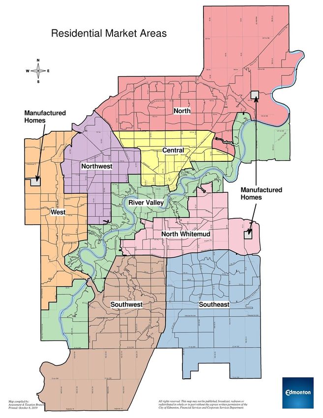
residential land market areas are defined in Edmonton. These market areas are:
● North ● Central ● Southwest
● West ● River Valley ● Southeast
● Northwest ● North Whitemud
The boundaries of these market areas are identified on the following page. A valuation model was
created for each market area (excluding manufactured home park lands- for this inventory refer to
the 2021 Multi-Residential Manufactured Home Park Land assessment methodology guide).
Copyright of this material and content is owned by the City of Edmonton and none of the content and material may be
copied, reproduced, posted or transmitted in any form without the prior written consent of the City of Edmonton, unless
otherwise being used in accordance with Section 299 and 300 of the Municipal Government Act, R
SA 2000, c M-26.2021 Residential Land
Assessment Methodology Page | 11
Copyright of this material and content is owned by the City of Edmonton and none of the content and material may be
copied, reproduced, posted or transmitted in any form without the prior written consent of the City of Edmonton, unless
otherwise being used in accordance with Section 299 and 300 of the Municipal Government Act, R
SA 2000, c M-26.2021 Residential Land
Assessment Methodology Page | 12
Neighbourhood
A property is located in this geographical area as defined by the City of Edmonton. Maps identifying
these neighbourhood boundaries are accessible on the City website,
http://maps.edmonton.ca/map.aspx (choose “Neighbourhood” in the “I’m looking for” drop-down
menu).
Study area
Within the market areas, there are sub-groups or sub-sectors of properties within neighbourhoods
that show different market trends from the rest of the neighbourhood they are located in. These
properties are assigned to study areas to more accurately analyze and value the market trends in
these locations.
● Neighbourhood study areas
Maps identifying these study areas are accessible on the City website,
“https://www.edmonton.ca/residential_neighbourhoods/property_tax_assessment/reference
-materials.aspx .
● Rural Re
sidential study areas
The market areas also contain groups of rural residential properties identified by their
assigned effective zoning code (‘RR’). These properties, with larger acreage sized lots, exist in
recognized subdivisions with servicing that may differ from the rest of the surrounding
neighbourhoods. Maps identifying these study areas are accessible on the City website,
https://www.edmonton.ca/residential_neighbourhoods/property_tax_assessment/reference-
materials.aspx .
Positive site influences
Golf course influence Greenbelt influence Lake influence
Noise attenuation barrier Park influence Ravine influence
River valley influence
The impact of a positive site influence may vary by other Factors Affecting Value. The following
positive site influences affecting assessment value are as listed (alphabetically):
Golf course influence
A property is located in close proximity to a golf course.
● Abutting
Property backs directly onto a golf course or is separated from it only by a park, green space
or walking trail.
● Across from, major
Property is separated from a golf course by a road or lane normally used by local traffic (with
traffic count equal to or less than 5,000). The separation by a local road or lane could also
include a park, green space or walking trail.
Copyright of this material and content is owned by the City of Edmonton and none of the content and material may be
copied, reproduced, posted or transmitted in any form without the prior written consent of the City of Edmonton, unless
otherwise being used in accordance with Section 299 and 300 of the Municipal Government Act, R
SA 2000, c M-26.2021 Residential Land
Assessment Methodology Page | 13
● Across from, minor
Property is separated from a golf course by a major road (with traffic count greater than
5,000). The separation by a major road could also include a park, green space or walking
trail.
Greenbelt influence
A property is next to a strip of publicly accessible green space.
This green space runs between residential properties, is between eight and 30 metres (26 and 98
feet) wide, includes public utility corridors and may have a walking trail. The greenbelt influence
does not include areas used for overhead transmission lines, parks, lakes, ravines, walkways or the
river valley.
For widths below eight metres, refer to the Walkway influence definition. For widths over 30 metres,
refer to the Park influence definition.
Lake influence
A property is in close proximity to a lake or storm reservoir.
● Abutting
Property backs directly onto a lake or large storm reservoir.
● Abutting, minor
Property backs onto a lake or large storm reservoir but is separated from it by a park, green
space or walking trail.
● Across from
Property is separated from a lake or storm reservoir by a road or lane normally used by local
traffic. The separation by a local road or lane could also include a park, green space or
walking trail.
Noise attenuation barrier
Noise attenuation barriers are structures designed to protect from noise pollution. They are located
in proximity to noise sources like commercial, industrial, institutional, LRT, multi-residential, utility,
railway or traffic.
Barriers include earthen berms, concrete wall structures and corrugated steel wall structures or
their combination with a minimum combined height of six feet. Noise attenuation barriers do not
include wooden screen fences typically erected by either the City or property owners.
● Minor
The barrier is between six and 10 feet high and is located on the property line.
● Moderate
The barrier is between six and 10 feet high when measured from the side that faces the
noise source. Or, the barrier is between 10 and 20 feet high and is located on the property
line.
● Major
The barrier is between 10 and 20 feet high when measured from the side that faces the
noise source. Or, the barrier is more than 20 feet high and is located on the property line.
Copyright of this material and content is owned by the City of Edmonton and none of the content and material may be
copied, reproduced, posted or transmitted in any form without the prior written consent of the City of Edmonton, unless
otherwise being used in accordance with Section 299 and 300 of the Municipal Government Act, R
SA 2000, c M-26.2021 Residential Land
Assessment Methodology Page | 14
● Extreme
The barrier is more than 20 feet high when measured from the side that faces the noise
source.
Park influence
A property is in close proximity to a park.
Parks include any developed or undeveloped green space, neighbourhood parks, cul-de-sac islands
and flat, wooded areas. They may or may not have walking trails. Parks exclude greenbelts, lakes,
ravines, walkways, the river valley and any areas used for overhead transmission lines.
● Abutting, major
Property has a common boundary with a park. The park is more than 0.75 hectares (1.85
acres) in total size and is at least 30 metres (98 feet) wide when measured from the property
line.
● Across from, major
Property is across a road or lane from a park. The park is more than 0.75 hectares (1.85
acres) in total size and is at least 30 metres (98 feet) wide.
● Abutting, minor
Property has a common boundary with a park. The park ranges between 0.25 hectares (0.62
acres) and 0.75 hectares (1.85 acres) in total size and is at least 30 metres (98 feet) wide.
Or, property has a common boundary with a major park. However, the portion of the park
that abuts the property is less than 30 metres (98 ft) wide when measured from the property
line.
● Across from, minor
Property is across a road or lane from a park. The park ranges between 0.25 hectares (0.62
acres) and 0.75 hectares (1.85 acres) in total size and is at least 30 metres (98 ft) wide.
Or, property is across a road or lane from a major park where the portion of the park is less
than 30 metres (98 ft) wide.
● Abutting, recreational
Property has a common boundary with a park or green spaces used for recreational
purposes: playgrounds, soccer or football fields, baseball diamonds, outdoor hockey rinks or
open fields within 91 metres (300 feet) of a school.
● Across from, recreational
Property is located across a road or lane from a park or green space used for recreational
purposes: playgrounds, soccer or football fields, baseball diamonds, outdoor hockey rinks or
open fields within 91 metres (300 feet) of a school.
Ravine influence
A property is in close proximity to a ravine (land included in the City's protection overlay).
● Abutting
Property backs directly onto a portion of a ravine or is separated from it by parks, green
spaces or walking trails. Property assessors classify the ravine influence as abutting when
the portion of the ravine is more than 50 metres (164 feet) wide.
● Abutting, minor
Property backs directly onto a portion of a ravine or is separated from it only by parks, green
Copyright of this material and content is owned by the City of Edmonton and none of the content and material may be
copied, reproduced, posted or transmitted in any form without the prior written consent of the City of Edmonton, unless
otherwise being used in accordance with Section 299 and 300 of the Municipal Government Act, R
SA 2000, c M-26.2021 Residential Land
Assessment Methodology Page | 15
spaces or walking trails. Property assessors classify the ravine influence as “abutting, minor”
when the portion of the ravine is less than 50 metres (164 feet) wide.
● Across from, major
Property is separated from a ravine by a road or lane normally used by local traffic. The
separation by the local road or lane may also include parks, green spaces and walking trails.
● Across from, minor
Property is separated from a ravine by a major road (not solely used by local traffic). The
separation by a major road may also include parks, green spaces and walking trails.
River valley influence
A property is in close proximity to or within the boundaries of the North Saskatchewan River Valley
(land included in the City's protection overlay).
● Abutting
Property backs directly onto the boundary of the river valley or is separated from it only by
parks, green spaces, wooded areas, walking trails or golf courses.
Where property is located within the river valley (for example, in neighbourhoods like
Rossdale, Riverdale and Cloverdale), it receives an abutting river valley influence factor if it
backs directly onto the bank of the North Saskatchewan River or is separated from the bank
by parks, green spaces, wooded areas, walking trails and golf courses.
● Across from, major
Property is separated from the boundaries of the river valley by a road or lane normally
used by local traffic. This separation may also include parks, green spaces, wooded areas,
walking trails and golf courses.
Where property is located within the river valley (for example, in neighbourhoods like
Rossdale, Riverdale and Cloverdale), it receives a major river valley influence factor if it is
separated from the bank of the North Saskatchewan River by a road or lane normally used
by local traffic. This separation may also include parks, green spaces, wooded areas, walking
trails and golf courses.
● Across from, minor
Property is separated from the boundaries of the river valley by a major road (not solely
used by local traffic). This separation may also include parks, green spaces, wooded areas,
walking trails and golf courses.
Where property is located within the river valley (for example, in neighbourhoods like
Rossdale, Riverdale and Cloverdale), it receives a minor river valley influence factor if it is
separated from the bank of the North Saskatchewan River by a major road (not solely used
by local traffic). This separation may also include parks, green spaces, wooded areas, walking
trails and golf courses.
Copyright of this material and content is owned by the City of Edmonton and none of the content and material may be
copied, reproduced, posted or transmitted in any form without the prior written consent of the City of Edmonton, unless
otherwise being used in accordance with Section 299 and 300 of the Municipal Government Act, R
SA 2000, c M-26.2021 Residential Land
Assessment Methodology Page | 16
Negative site influences
Cemetery influence Commercial influence Industrial influence
Institutional influence LRT influence Multi-residential influence
Railway influence Traffic influence Utilities influence
Walkway influence
The impact of a negative site influence may vary by other Factors Affecting Value. The following
negative site influences affecting assessment value are as listed (alphabetically):
Cemetery influence
A property is adjacent to a cemetery.
Commercial influence
A property is in close proximity to a commercial property.
● Minor
Property receives a minor commercial influence factor if it has one commercial property like
a neighbourhood office building, corner store, gas station, shop or convenience store in
front, behind or beside.
● Moderate
Property receives a moderate commercial influence factor if it has
○ two small commercial properties like a neighbourhood corner store, gas station,
shop or convenience store or
○ one large commercial property like a neighbourhood strip mall, hotel or fast food
facility in front, behind or beside.
● Major
Property receives a major commercial influence factor if it has one of the following or a
combination of
○ three or more commercial properties that create minor influence,
○ two or more commercial properties that create moderate influence or
○ one commercial property like a mall, box centre or bar in front, behind or beside.
Industrial influence
A property is in close proximity to an industrial property.
● Minor
Property receives a minor industrial influence factor if it has one industrial property or
vacant industrial land in front, behind or beside.
Copyright of this material and content is owned by the City of Edmonton and none of the content and material may be
copied, reproduced, posted or transmitted in any form without the prior written consent of the City of Edmonton, unless
otherwise being used in accordance with Section 299 and 300 of the Municipal Government Act, R
SA 2000, c M-26.2021 Residential Land
Assessment Methodology Page | 17
● Moderate
Property receives a moderate industrial influence factor if it has two or three industrial
properties in front, behind or beside.
● Major
Property receives a major industrial influence factor if it has one of the following or a
combination of
○ one industrial property that emits a large amount of pollution or smell (for example,
the Gold Bar Wastewater Treatment Plant) or
○ more than three industrial properties in front, behind or beside.
Institutional influence
A property is in close proximity to an institutional facility.
● Minor
Property receives a minor institutional influence factor if one institution like a church,
elementary school, ski hill, community hall or community recreation facility is abutting or
across a lane or road with moderate or lower traffic counts.
● Moderate
Property receives a moderate institutional influence factor if
○ it has two institutions like a church, elementary school, ski hill or community hall or
○ one institution like a high school, junior high school, outdoor community pool or
stand-alone police station is abutting or across a lane or road with moderate or
lower traffic counts.
● Major
Property receives a major institutional influence factor if it has one of the following or a
combination of
○ three or more institutions that create minor influence,
○ two or more institutions that create moderate influence or
○ one major institution (for example, a large sports or recreation facility like
Commonwealth Stadium, Telus Field, or Terwillegar Recreation Centre, a
post-secondary institution, hospital or other emergency facility) is abutting or across
a lane or road with moderate or lower traffic counts.
LRT influence
A property is in close proximity to the Edmonton Light Rail Transit (LRT) system.
● Abutting
Property backs directly onto an LRT right of way or is separated from it only by parks, green
spaces, walking trails or walkways.
● Across from
Property is separated from an LRT right of way by a road or lane. The separation by a road
or lane could also include a park, green space and walking trail.
Copyright of this material and content is owned by the City of Edmonton and none of the content and material may be
copied, reproduced, posted or transmitted in any form without the prior written consent of the City of Edmonton, unless
otherwise being used in accordance with Section 299 and 300 of the Municipal Government Act, R
SA 2000, c M-26.2021 Residential Land
Assessment Methodology Page | 18
Multi-residential influence
A property is in close proximity to a multi-residential property (condominiums, rental apartments or
rental row houses).
Multi-residential properties considered for this influence must
● abut a property; or
● be located across lanes or roads with moderate or lower traffic counts; or
● be within 50 metres of a property and separated by utility right of ways, parks, lakes or other
green spaces; and
● not be individually titled when it comes to single-family triplexes, fourplexes and row houses.
This classification is based on the total unit count from the adjacent multi-residential property and
any other multi-residential properties contiguous to it (or separated only by small gaps of land like
lanes, greenbelts or walkways).
● Minor
Property is in close proximity to multi-residential properties with a total unit count of four to
30.
● Moderate
Property is in close proximity to multi-residential properties with a total unit count of 31 to
75.
● Major
Property is in close proximity to multi-residential properties with a total unit count of more
than 75.
Railway influence
A property is in close proximity to a railway.
● Minor
Property backs directly onto or is adjacent to a rail right of way with single or multiple rail
lines. Property also could be separated from the rail right of way by a road or lane.
● Moderate
Property directly backs onto or is adjacent to a railway yard or switching station. Property
also could be separated from the railway yard or switching station by a road or lane.
Traffic influence
A property is adjacent to a traffic source. We assign these factors according to the latest City traffic
count data
[https://www.edmonton.ca/transportation/traffic_reports/traffic-reports-flow-maps.aspx].
● Minor
Property is adjacent to a road with the recorded traffic flow of 1,500-5,000 vehicles per day
or with an Edmonton Transit System bus route.
● Moderate
Property is adjacent to a road with the recorded traffic flow of 5,001-15,000 vehicles per day.
● Major
Property is adjacent to a road with the recorded traffic flow of 15,001-50,000 vehicles per
day (for example, 50th Street, 170th Street or 97th Street).
Copyright of this material and content is owned by the City of Edmonton and none of the content and material may be
copied, reproduced, posted or transmitted in any form without the prior written consent of the City of Edmonton, unless
otherwise being used in accordance with Section 299 and 300 of the Municipal Government Act, R
SA 2000, c M-26.2021 Residential Land
Assessment Methodology Page | 19
● Extreme
Property is adjacent to a road with the recorded traffic flow of more than 50,000 vehicles per
day (for example, Whitemud Drive or Yellowhead Trail)
● Anthony Henday Drive
Property is adjacent to the Anthony Henday Drive ring road.
Utility influence
A property is in close proximity to utilities.
● Minor
Property receives a minor utility influence factor if it is adjacent to underground utilities (like
high pressure pipelines) generally located within a green belt.
Municipal utility services such as low-voltage power lines, gas lines, telecommunications
lines and municipal water, sanitary and storm sewer lines are not included in this category.
● Moderate
Property receives a moderate utility influence factor if it is adjacent to overhead
transmission lines generally located within a green belt or if it’s adjacent to
telecommunication transmission towers.
Municipal utility services such as low-voltage power lines, gas lines, telecommunications
lines and municipal water, sanitary and storm sewer lines are not included in this category.
● Substation, minor
Property receives a substation, minor utility influence factor if it is adjacent to a utility
substation other than an overhead transmission line substation. These substations include
municipal utility services such as low-voltage power substations, gas substations,
telecommunications substations and municipal water, sanitary and storm sewer substations
● Substation, major
Property receives a substation, major utility influence factor if it is adjacent to an overhead
transmission line substation.
Walkway influence
A property shares a border with a walkway that connects a residential area—either directly or as
part of a trail system—to commercial or institutional areas or major roadways.
Walkways are less than eight metres (26.2 feet) wide and located between two residential
properties.
For widths over eight metres, refer to the Greenbelt influence definition.
Copyright of this material and content is owned by the City of Edmonton and none of the content and material may be
copied, reproduced, posted or transmitted in any form without the prior written consent of the City of Edmonton, unless
otherwise being used in accordance with Section 299 and 300 of the Municipal Government Act, R
SA 2000, c M-26.2021 Residential Land
Assessment Methodology Page | 20
Lot Characteristics
Corner lot Lot shape Lot size
Walkout grading
The impact of a lot characteristic may vary by other Factors Affecting Value. The following lot
characteristics affecting assessment value are as listed (alphabetically):
Corner lot
Land is located at the intersection of two public roadways, other than lanes.
For a detailed definition, see the Edmonton Zoning Bylaw 12800 (part 1, section 6.1).
Lot shape
A property is of irregular or pie shape.
● Pie
The front width of the lot is significantly smaller than the back width, which results in an
overall “pie” shape.
● Irregular
The shape of the lot is substantially different from a rectangular-, pie- or otherwise regularly
shaped residential lot. It could be, for example, a triangular lot, L-shaped lot or a lot with a
“panhandle.”
Lot size
Lot size is the total size of land.
The calculation of this area is done by the City’s Global Information System (software for analyzing
geographical data) and based on the legal description of the property.
Walkout grading
A property displays substantial grade differences from the front to the back of the lot that could
allow for the development of a walkout basement.
Adjustments
Adverse topography Contamination Encumbrance
Lot area with applied Lot instability Remnant lot
adjustment
Servicing
Copyright of this material and content is owned by the City of Edmonton and none of the content and material may be
copied, reproduced, posted or transmitted in any form without the prior written consent of the City of Edmonton, unless
otherwise being used in accordance with Section 299 and 300 of the Municipal Government Act, R
SA 2000, c M-26.2021 Residential Land
Assessment Methodology Page | 21
Adjustments may be made for the following:
Adverse topography
Adverse topography indicates a property has certain topographical constraints that are not typical
for the area and negatively affect the overall suitability of land for residential development.
These constraints may include, but are not limited to, significant slopes or wetland subsoil
conditions resulting from sloughs, ponds and natural drainage onto the property.
● Minor
The adverse topography does not significantly impede developmental potential of the
affected area. The area still provides some benefit to the owner, such as use or enjoyment of
the land.
● Moderate
The adverse topography has a potential to significantly impede developmental potential of
the affected area. However, the area still provides some benefit to the owner, such as use or
enjoyment of the land.
● Major
The adverse topography significantly impedes developmental potential of the affected area.
The area provides no reasonable benefit to the owner.
Note: The Adverse topography adjustment is not applied to properties located in close proximity to or
within the boundaries of the North Saskatchewan River Valley (land included in the City's protection
overlay) or in close proximity to a ravine (land included in the City's protection overlay).
Contamination
Contamination refers to property that has been affected by environmental contamination which
includes adverse conditions resulting from the release of hazardous substances into surface water,
groundwater, or soil.
Encumbrance
A property has a registered encumbrance on title that runs with the land, such as an easement or
restrictive covenant. This encumbrance and the area of the lot that it affects are atypical for similar
properties in the area.
Encumbrance does not include municipal utility services—such as low-voltage power, gas,
telecommunication, water, sanitary sewer and storm sewer lines—that typically serve the property.
● Minor
The encumbrance does not significantly impede developmental potential of the affected
area. The area still provides some benefit to the owner, such as use or enjoyment of the
land.
● Moderate
The encumbrance has the potential to significantly impede developmental potential of the
affected area. However, the area still provides some benefit to the owner, such as use or
enjoyment of the land.
● Major
The encumbrance significantly impedes developmental potential of the affected area. The
area provides no reasonable benefit to the owner.
Copyright of this material and content is owned by the City of Edmonton and none of the content and material may be
copied, reproduced, posted or transmitted in any form without the prior written consent of the City of Edmonton, unless
otherwise being used in accordance with Section 299 and 300 of the Municipal Government Act, R
SA 2000, c M-26.2021 Residential Land
Assessment Methodology Page | 22
Lot area with applied adjustment
A property received an assessment adjustment to a portion of the total lot size due to the negative
impacts of encumbrance, adverse topography or irregular shape.
Lot instability
Lot instability signals that land at the top of a bank area of a property has experienced slope
movement or erosion; therefore, the bearing capacity of the ground became diminished. Any lot
instability must occur on the property being assessed and is applied only if lot instability has already
occurred.
● Minor
Land has experienced slope movement or erosion, which
(a) is apparent and more than incidental in scope but does not immediately threaten
structures or the use of the amenities on that property; or
(b) has led to ongoing monitoring by a geotechnical professional to ensure continued slope
stability.
● Moderate
Land has experienced slope movement or erosion, which
(a) impairs or precludes use of a significant portion of the developed part of the property;
(b) has resulted in ongoing monitoring by Safety Codes Officers; or
(c) poses a risk to the ongoing safe occupancy of the house or primary structure on the
property.
● Major
Land has experienced severe slope movement or erosion, which
(a) has rendered a substantial portion of the top of bank area of the property unusable,
hazardous or in need of substantial stabilization work, as a result of a landslide or major
slope failure;
(b) has subjected the property to a Safety Codes Act order that requires ongoing
geotechnical monitoring regarding the continued use of the property or its structures; or
(c) made the house unsafe for continued occupancy, or made any continued occupancy
contingent upon compliance with a Safety Codes Act order.
Remnant lot
A property is a vacant lot deemed undevelopable for residential use due to the size restrictions set
under Edmonton Zoning Bylaw 12800.
Servicing
The Servicing variables below do not apply to Rural Residential lots.
● Water supply service
Water supply refers to the public water supply infrastructure available to a property.
Property is considered serviced if a branch (stub) line from the City of Edmonton or EPCOR
main line to the property line exists.
○ Present
A property has water supply services.
○ Absent
A property does not have water supply services.
● Sanitary sewer service
Sanitary sewer refers to a system of sewers designed to collect and convey household and
industrial wastewater from urban areas to Edmonton’s Gold Bar Wastewater Treatment
Copyright of this material and content is owned by the City of Edmonton and none of the content and material may be
copied, reproduced, posted or transmitted in any form without the prior written consent of the City of Edmonton, unless
otherwise being used in accordance with Section 299 and 300 of the Municipal Government Act, R
SA 2000, c M-26.2021 Residential Land
Assessment Methodology Page | 23
Plant. Property is considered serviced if a branch (stub) line from the City of Edmonton or
EPCOR main line to the property line exists.
○ Present
A property is connected to Edmonton’s sanitary sewer system.
○ Absent
A property is not connected to Edmonton’s sanitary sewer system.
● Storm sewer service
Storm sewer refers to a system of sewers designed to collect, store and convey runoff from
urban areas to a receiving body of water. Property is considered serviced if it’s located next
to a road with storm water sewer.
○ Present
A property is considered to be connected to Edmonton’s storm sewer system.
○ Absent
A property is not connected to Edmonton’s storm sewer system.
● Access to paved public roads
Paved public roads are part of the public road access infrastructure and must be adjacent to
the property.
○ Present
A paved public road is adjacent to the property.
○ Absent
A paved public road is not adjacent to the property.
Access to paved public roads doesn’t include paved back lanes and alleys.
● Access to sidewalks, curbs or gutters
Sidewalks, curbs and gutters are part of the City’s public road and sidewalk access
infrastructure and must be adjacent to the property.
○ Present
Sidewalks, curbs and gutters are adjacent to the property.
○ Absent
Sidewalks, curbs and gutters are not adjacent to the property.
● Street lighting
Street lighting is part of the City’s public road and sidewalk access infrastructure and must
be adjacent to the property.
○ Present
Street lighting is adjacent to the property.
○ Absent
Street lighting is not adjacent to the property.
Copyright of this material and content is owned by the City of Edmonton and none of the content and material may be
copied, reproduced, posted or transmitted in any form without the prior written consent of the City of Edmonton, unless
otherwise being used in accordance with Section 299 and 300 of the Municipal Government Act, R
SA 2000, c M-26.2021 Residential Land
Assessment Methodology Page | 24
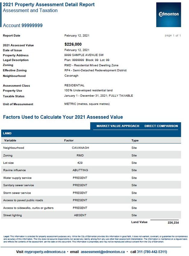
Sample Assessment Detail Report
On the sample shown below, the factors and variables used to calculate each individual property
assessment are displayed in the ‘Factors Used to Calculate Your 2021 Assessed Value’ section of
each property’s Property Assessment Detail Report.
Copyright of this material and content is owned by the City of Edmonton and none of the content and material may be
copied, reproduced, posted or transmitted in any form without the prior written consent of the City of Edmonton, unless
otherwise being used in accordance with Section 299 and 300 of the Municipal Government Act, R
SA 2000, c M-26.2021 Residential Land
Assessment Methodology Page | 25
Methods to Adjust Comparables
There are two techniques for adjusting comparables: quantitative a
nd qualitative.
Quantitative Adjustments
Each characteristic of a property can be measured or quantified by a mathematical expression and
adjusted for.
Several techniques are available to quantify adjustments to the sale prices of comparable
properties: data analysis techniques such as paired data analysis, grouped data analysis, and
secondary data analysis, statistical analysis, including graphic analysis…
AIC, 2010, p. 14.2
In the direct comparison approach, the best comparables are those sales that require the least
absolute adjustment.
AIC, 1995, p. 245
Quantitative adjustments involve adjusting a known value (sale price for example) by adding or
subtracting an amount that a given characteristic adds to or subtracts from that value. A quantitative
adjustment should be made for each characteristic that differs between the subject property and
the comparable property.
Due to the legislative requirement to use mass appraisal, the City has used statistical analysis to
determine annual assessments.
“coefficient” means a number that represents the quantified relationship of each variable to the
assessed value of a property when derived through a mass appraisal process.
MRAT s.31(a)
The City is not required to disclose the coefficients. In the absence of quantitative adjustments, an
alternative technique is qualitative analysis.
Qualitative Analysis
Each comparable property is compared with the subject property on an overall basis. In a qualitative
analysis, comparable properties are identified as inferior, similar, or superior overall to the subject
property in order to bracket the probable value range of the subject property.
Copyright of this material and content is owned by the City of Edmonton and none of the content and material may be
copied, reproduced, posted or transmitted in any form without the prior written consent of the City of Edmonton, unless
otherwise being used in accordance with Section 299 and 300 of the Municipal Government Act, R
SA 2000, c M-26.2021 Residential Land
Assessment Methodology Page | 26
When a sale property is considered to offer important market evidence but finding the means to
make quantitative adjustments is lacking, the appraiser may turn to other major direct
comparison techniques, qualitative analysis.
(AIC, 2005, p. 19.10)
Qualitative analysis recognizes … the difficulty in expressing adjustments with mathematical
precision.
(AIC, 2010, p. 14.6 )
…reliable results can usually be obtained by bracketing the subject between comparables that are
superior and inferior to it.
(AIC, 2010, p. 14.7)
If one or two comparable properties require fewer total adjustments than the other comparable
transactions, an appraiser may attribute greater accuracy and give more weight to the value
indications obtained from these transactions, particularly if the magnitude of the adjustments is
approximately the same.
(AIC, 2010, p. 13.16)
Copyright of this material and content is owned by the City of Edmonton and none of the content and material may be
copied, reproduced, posted or transmitted in any form without the prior written consent of the City of Edmonton, unless
otherwise being used in accordance with Section 299 and 300 of the Municipal Government Act, R
SA 2000, c M-26.2021 Residential Land
Assessment Methodology Page | 27
References
City of Edmonton. (2018). Zoning Bylaw No. 12800. Retrieved from City of Edmonton:
http://webdocs.edmonton.ca/InfraPlan/zoningbylaw/bylaw_12800.htm
Eckert, J., Gloudemans, R., & Almy, R. (1990). Property Appraisal and Assessment Administration.
Chicago, Illinois: International Association of Assessing Officers.
International Association of Assessing Officers [IAAO]. (1997). Glossary for Property Appraisal and
Assessment. Chicago IL.
Province of Alberta. Matters Relating to Assessment and Taxation Regulation, 2018. Retrieved from
Service Alberta, Queen's Printer: http://www.qp.alberta.ca
Province of Alberta. Municipal Government Act. Edmonton, AB: Queen's Printer.
Appraisal Institute of Canada (1995). Basics of Real Estate Appraising Fourth Edition. Winnipeg, Canada.
Appraisal Institute of Canada (2005). The Appraisal of Real Estate Second Canadian Edition. Vancouver,
Canada.
Appraisal Institute of Canada (2010). The Appraisal of Real Estate Third Canadian Edition. Vancouver,
Canada.
Copyright of this material and content is owned by the City of Edmonton and none of the content and material may be
copied, reproduced, posted or transmitted in any form without the prior written consent of the City of Edmonton, unless
otherwise being used in accordance with Section 299 and 300 of the Municipal Government Act, R
SA 2000, c M-26.2021 Residential Land
Assessment Methodology Page | 28
Appendix
Zone Chart: Residential
Residential Zonings
Single Detached Residential Zone (s.110) i s to provide for single detached
RF1
housing while allowing other forms of small scale housing
Residential Small Lot Zone (s.115) i s to provide for smaller lot single detached
RSL
housing with attached garages
Low Density Infill Zone (s.120) is to retain single detached housing, while allowing
RF2
infill on narrow lots, uses include duplex housing
Planned Lot Residential Zone (s.130) is to provide for small lot single detached
RPL
housing, serviced by both a public roadway and a lane
Small Scale Infill Development Zone (s.140) i s to provide for single detached
RF3 housing and semi-detached housing while allowing small-scale conversion and infill
redevelopment to buildings containing up to four dwellings
Semi-Detached Residential Zone (s.150) i s to provide a zone primarily for
RF4
Semi-detached Housing and Duplex Housing
Residential Mixed Dwelling Zone (s.155) is to provide for a range of dwelling
RMD
types and densities including single detached, semi-detached and row housing
Row Housing Zone (s.160) s to provide for relatively low to medium density
RF5
housing, generally referred to as Row Housing
Urban Character Row Housing Zone (s.165) is to provide for medium density Row
UCRH Housing in a manner that is characteristic of urban settings and can include more
intensive development
Medium Density Multiple Family Zone (s.170) is to provide for medium density
RF6
housing, where some units may not be at Grade
Copyright of this material and content is owned by the City of Edmonton and none of the content and material may be
copied, reproduced, posted or transmitted in any form without the prior written consent of the City of Edmonton, unless
otherwise being used in accordance with Section 299 and 300 of the Municipal Government Act, R
SA 2000, c M-26.2021 Residential Land
Assessment Methodology Page | 29
Residential Zonings
RA7 Low Rise Apartment Zone (s.210) provides for low rise apartment buildings
Medium Rise Apartment Zone (s.220) provides for medium rise apartment
RA8
buildings
RA9 High Rise Apartment Zone (s.230) provides for high rise apartment buildings
Rural Residential Zone (s.240) is to provide for single detached residential
RR development of a permanent nature in a rural setting, generally without the
provision of the full range of urban utility services
Mobile Home Zone (s.250) i s to provide for Mobile Homes developed within a
RMH
Mobile Home Park or Mobile Home Subdivision.
*For zonings not listed above, please see zoning Bylaw 12800.
Measure Conversion Chart
Imperial to Metric – Length Imperial to Metric – Area
1 inch (in) = 2
.54 centimetres (cm) 1 square foot (sqft) = 0
.09290 square metre (m2)
1 foot (ft) = 0
.3048 metres (m) 1 acre (ac) = 4
,046.86 square metre (m2)
Imperial Conversions 1 acre (ac) = 0
.40469 hectares (ha)
1 acre (ac) = 4
3,560 square feet (sqft) Metric Conversions
1 square mile = 640 acres (ac) 1 square kilometer (sq km) = 1
00 hectares (ha)
1 section = 6
40 acres (ac) 1 hectare (ha) = 1
0,000 square metres (m2)
Copyright of this material and content is owned by the City of Edmonton and none of the content and material may be
copied, reproduced, posted or transmitted in any form without the prior written consent of the City of Edmonton, unless
otherwise being used in accordance with Section 299 and 300 of the Municipal Government Act, R
SA 2000, c M-26.You can also read