GREATER SHEPPARTON PLANNING SCHEME PLANNING PERMIT APPLICATION 2017-301
←
→
Page content transcription
If your browser does not render page correctly, please read the page content below
GREATER SHEPPARTON PLANNING SCHEME
 PLANNING PERMIT APPLICATION 2017-301

        SOLAR FARM PROJECT LEMNOS

STATEMENT OF EVIDENCE BY ANDREW CLARKE
          ON PLANNING ISSUES

       Prepared for Neoen Australia Pty Ltd

                     MAY 2018

           Matrix Planning Australia Pty Ltd
                     A.C.N. 096 741 552

               2nd  Floor, 50 Budd Street
               Collingwood Victoria 3066
                Tel: +61 (3) 9419 3222
                Fax: +61 (3) 9419 3244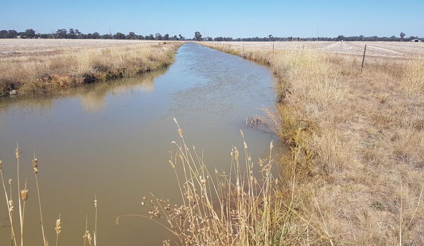
SOLAR FARM PROJECT LEMNOS

                                                            CONTENTS

1     INTRODUCTION: PRACTICE NOTE – EXPERT EVIDENCE.................................................................. 1

2     SUBJECT SITE & ENVIRONS ............................................................................................................. 2

3     THE PROPOSAL ............................................................................................................................... 6

4     PLANNING POLICIES & CONTROLS ................................................................................................. 7

    4.1     STATE PLANNING POLICY FRAMEWORK ........................................................................................... 7
    4.2     LOCAL PLANNING POLICY FRAMEWORK ........................................................................................... 8
      4.2.1        Municipal Strategic Statement ........................................................................................ 8
      4.2.2        Local Planning Policies................................................................................................... 10
    4.3     EXISTING PLANNING CONTROLS ................................................................................................... 10
      4.3.1        Zoning ............................................................................................................................ 10
      4.3.2        Overlays ......................................................................................................................... 12
          4.3.2.2           Land Subject to Inundation Overlay ...................................................................... 13
      4.3.3        Particular Provisions ...................................................................................................... 14

5     OTHER STRATEGIC PLANNING DOCUMENTS................................................................................ 14

    5.1     HUME REGIONAL GROWTH PLAN ................................................................................................. 14
    5.2     REGIONAL RURAL LAND USE STRATEGY ......................................................................................... 16
    5.3     RENEWABLE ENERGY ACTION PLAN .............................................................................................. 17

6     PLANNING CONSIDERATIONS ....................................................................................................... 17

    6.1     INSTRUCTIONS ........................................................................................................................... 17
    6.2     NATIVE VEGETATION AND FLOODING ............................................................................................ 17
    6.3     AGRICULTURE AND RENEWABLE ENERGY ....................................................................................... 18

7     CONCLUSIONS .............................................................................................................................. 21

P18009
SOLAR FARM PROJECT LEMNOS

1           INTRODUCTION: PRACTICE NOTE – EXPERT EVIDENCE
            Name and Address of Expert
            Andrew Clarke
            Director
            Matrix Planning Australia
            2nd Floor, 50 Budd Street
            Collingwood Vic 3066.
            Qualifications of Expert
            Bachelor of Town and Regional Planning (Hons), University of Melbourne, 1982
            Member, Planning Institute of Australia
            Refer Curriculum Vitae at Attachment 1.
            Any Private or Business Relationship between the Expert Witness and the Party for Whom
            the Report is Prepared
            None.
            Instructions
            Written instructions from White & Case Lawyers acting on behalf of Neoen Australia Pty Ltd
            dated 29 March 2018 as follows:
                       “ We would like you to prepare an expert witness statement for the panel
                         in which you consider the Project’s compliance with all relevant objectives
                         and strategies of the Greater Shepparton Planning Scheme.
                        We would also like you to consider the submissions that are relevant to
                        your area of expertise and respond to any matters in your witness
                        statement.”
            Facts, Matters and Assumptions
            Facts, matters and assumptions on which opinions expressed in the report are based are set
            out in the report.
            Documents and Materials Taken Into Account
            The documents and any literature or other materials taken into account in preparing the
            report are identified in the report.
            Examinations, Tests and Investigations
            All examinations, tests and investigations have been undertaken by me.
            Summary of Opinion
            A summary of opinion is included in the Conclusion.

P18009                                                                                                 1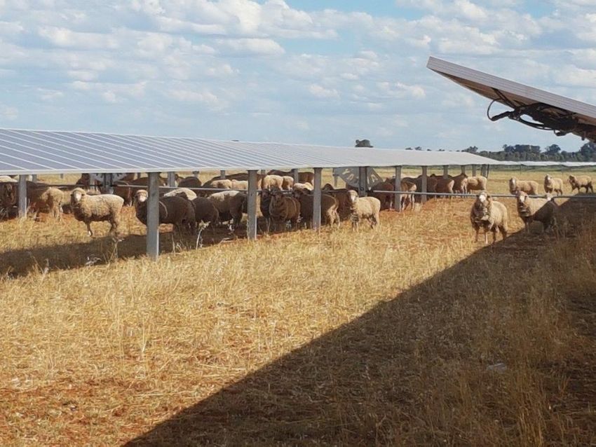
SOLAR FARM PROJECT LEMNOS
Provisional Opinion
There are no provisional opinions.
Relevant Questions Outside of Expertise
There are no matters of relevance outside of my expertise.
Whether the report is incomplete or inaccurate in any respect
As far as I am aware the report is not incomplete or inaccurate in any respect.
Declaration
I have made all the enquiries which I believe are desirable and appropriate, and that no
matters of significance which I regard as relevant have to my knowledge been withheld from
the Panel.
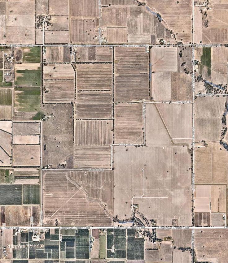
2 SUBJECT SITE & ENVIRONS
The subject site comprises 9 lots located approximately 5 km north-east of Shepparton City
in a predominantly rural area. It is collectively known as:
1220 Cosgrove-Lemnos Road Lemnos
1190 Cosgrove-Lemnos Road, Lemnos
875 Boundary Road Lemnos
260 Tank Corner East Road Lemnos
85 Crooked Lane Lemnos.
The subject site collectively comprises an irregular shaped parcel of land comprising 482 ha
(Refer Map 1 and Aerial Photograph over page).
At the time of my inspection the subject site had been substantially cleared of vegetation
and appeared as predominantly cleared pasture. A dwelling existed on 260 Tank Corner East
Road adjacent to its road frontage and 85 Crooked Lane near its first bend north of Lemnos-
Cosgrove Road. The only area under horticulture was a relatively small neglected orchard
immediately west of the dwelling fronting Tank Corner East Road.
The subject site like much of the Greater Shepparton area is flat. Windrows define some
paddocks, but otherwise the subject site contains only scattered trees.
Some minor creek/drainage lines and irrigation channels pass through or are adjacent to the
subject site.
Land uses surrounding the subject site to the west, north and east include similar grazing
land both with and without livestock at the time of my inspection and scattered houses
particularly on some of the smaller lots surrounding the subject site.
The south side of Cosgrove-Lemnos Road is characterised by a number of orchards some of
which also accommodate dwellings.
P18009 2
SOLAR FARM PROJECT LEMNOS

                                                           Map 1: Subject site

                            View of the subject site from the corner of Cosgrove-Lemnos Road and Cro0oked Lane

P18009                                                                                                           3
SOLAR FARM PROJECT LEMNOS

                                                            Aerial Photograph

                            View of the subject site from the corner of Lemnos-Cosgrove Road and Boundary Road

P18009                                                                                                           4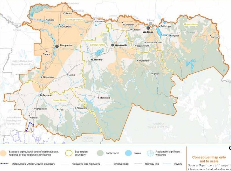
SOLAR FARM PROJECT LEMNOS

            High voltage transmission lines pass through the southern end of the site in an east-west
            direction.

                        Eastward view from Boundary Road along the alignment of high voltage transmission lines

                                          No 15 channel: southward view from Crooked Lane

P18009                                                                                                            5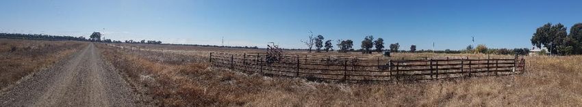
SOLAR FARM PROJECT LEMNOS
3 THE PROPOSAL
It is proposed to use and develop the site as a 100MW photovoltaic solar farm. The planning
report accompanying the application states it will include the following components:
400,000 solar panels mounted on 40,000 piles with a total height of 1.5-2.5 metres
above ground level;
Battery storage building;
56 photovoltaic boxes or skids across the site (each approximately 12.5 metres x 2.5
metres and 3.5 metres high);
Underground cabling;
Delivery station in the vicinity of the substation (12.5 metres x 3.5 metres and 3.4
metres high);
66kV substation (80 x 80 metres);
Operations and maintenance building (9 metres x 5 metres and 4 metres high);
A new access to Cosgrove-Lemnos Road, including a new crossing of the channel that
follows that road. A second emergency access point will be provided along Tank
Corner East Road;
Internal access tracks;
Security fencing (2.3 metres high) along the site’s perimeter;
Perimeter landscaping. I am instructed that landscaping is proposed along Cosgrove-
Lemnos Road and Tank Corner East Road. In addition, I am instructed that there has
been consultation with neighbours to address specific concerns about direct lines of
view from various points around the site, and these may still be subject to change. The
applicant also proposes establishing a landscaping fund for neighbours with direct
views over the site to also allow them to plant screening vegetation on their own
properties.
The proposed hours that the facility will be manned are stated to be:
Monday – Friday: 7am – 6pm
Saturday: 8am-1pm.
The planning report indicates 10,400 hours of work for on-site staff. I am instructed that
there will be a total of 5 equivalent full-time jobs on-site and off-site.
The estimated project life is 30 years. After that time the facilities will be de-commissioned
and removed and the site rehabilitated (presumably for agricultural use) or the facilities will
be reconditioned and the life of the project extended. Reconditioning of facilities and
extension of the project beyond 30 years does not form part of the current proposal.
P18009 6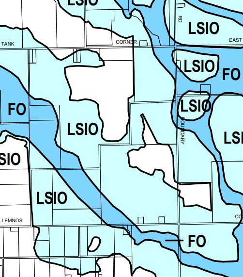
SOLAR FARM PROJECT LEMNOS
4 PLANNING POLICIES & CONTROLS
4.1 STATE PLANNING POLICY FRAMEWORK
The State Planning Policy Framework is the enunciation of State planning policies common
to all Victorian new format planning schemes. State planning policies relevant to this
Application include:
Clause 10.01: Integrated Decision Making, which seeks to balance conflicting
objectives in favour of net community benefit and sustainable development for the
benefit of present and future generations;
Clause 11.07: Regional Victoria, which includes the strategy to avoid development
impacts on land that contains high biodiversity values, landscape amenity, water
conservation values, food production and energy production capacity, extractable
resources and minerals, cultural heritage and recreation values, assets and recognised
uses;
Clause 11.12: Hume which has the economic objective to develop a more diverse
regional economy while managing and enhancing key regional economic assets.
Strategies to implement this objective include:
“ Plan for a more diverse and sustainable regional economy by supporting
existing economic activity and encouraging appropriate new and
developing forms of industry, agriculture, tourism and alternative energy
production.”
“ Avoid encroachment from rural residential settlement and other land uses
that are non-complementary to agriculture in areas identified as strategic
agricultural land and direct proposals for settlement to existing centres
and townships.
Support agricultural production through the protection and enhancement
of infrastructure and strategic resources such as water and agricultural
land, including areas of strategic agricultural land.”
“ Create renewable energy hubs that support co-location of industries to
maximise resource use efficiency and minimise waste generation.”
On the Hume Regional Growth Plan the subject site is designated as being in an area
of strategic agricultural land.
Clause 13.02-1: Floodplain Management, which seeks to assist the protection of life,
property and community infrastructure from flood hazard.
Clause 14.01-1 Protection of Agricultural Land. The objective is:
“ To protect productive farmland which is of strategic significance in the
local or regional context.
Relevant strategies include:
P18009 7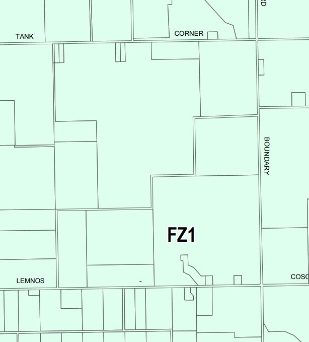
SOLAR FARM PROJECT LEMNOS
“ Ensure that the State’s agricultural base is protected from the unplanned
loss of productive agricultural land due to permanent changes of land use.”
“ Permanent removal of productive agricultural land from the State's
agricultural base must not be undertaken without consideration of its
economic importance for the agricultural production and processing
sectors.
In considering a proposal to subdivide or develop agricultural land, the
following factors must be considered:
The desirability and impacts of removing the land from primary
production, given its agricultural productivity.
The impacts of the proposed subdivision or development on the
continuation of primary production on adjacent land, with
particular regard to land values and to the viability of infrastructure
for such production.
The compatibility between the proposed or likely development and
the existing uses of the surrounding land.
Assessment of the land capability.”
Clause 15.02-1: Energy and Resource Efficiency. It includes the strategy to improve
efficiency in energy use through greater use of renewable energy.
Clause 19.01: Provision of Renewable Energy. The objective is to promote the
provision of renewable energy in a manner that ensures appropriate siting and design
considerations are met. Relevant strategies are:
“ Facilitate renewable energy development in appropriate locations.
Protect energy infrastructure against competing and incompatible uses.
Develop appropriate infrastructure to meet community demand for
energy services and setting aside suitable land for future energy
infrastructure.
In considering proposals for renewable energy, consideration should be
given to the economic and environmental benefits to the broader
community of renewable energy generation while also considering the
need to minimise the effects of a proposal on the local community and
environment.”
4.2 LOCAL PLANNING POLICY FRAMEWORK
4.2.1 Municipal Strategic Statement
The Municipal Strategic Statement (MSS) is the expression of the planning vision, objectives
and strategies at the municipal level of consideration.
P18009 8SOLAR FARM PROJECT LEMNOS
The Greater Shepparton Planning Scheme MSS identifies that the region has a strong and
vigorous rural economy based on irrigated and dry land agriculture. The region is often
described as the “food bowl” of Australia providing 25% of horticultural produce in the state.
The MSS refers to the ‘Regional Rural Land Use Strategy’ (RRLUS) prepared for the City of
Greater Shepparton and the Shires of Campaspe and Moira and notes that irrigated primary
production and the processing of that product underpin the municipality and the Region’s
economy. The level of production is nationally important and the region is responsible for
significant parts of the nation’s milk production, deciduous canned fruit production, stone
fruit crop and tomato processing production, with an annual value of agricultural production
at the farm gate of about $1.2 billion (2006). (Clause 21.01).
Relevant key influences and issues (Clause 21.02) include:
Land use strategies that provide for growth should be pursued whilst also protecting
the quality of agricultural land and encouraging the sustainable use of natural
resources such as land, water, air and biodiversity.
Agriculture is a significant land use in the municipality and underpins the local
economy directly through on farm employment and through the associated
manufacturing and food processing and industries servicing agriculture.
Horticulture is the most significant agricultural industry in terms of gross value of
agricultural production. Horticulture and the dairy industry is dependent on access to
a secure water supply via the irrigation network. Land use planning control needs to
protect the main production irrigated areas to secure their future for farming but also
integrate with the planned modernisation and reconfiguration of the systems and
potential expansion into the agricultural development areas.
The rural areas of the municipality are considered to be productive agricultural land
based on the soil types, subdivision pattern and climate and the significant level of
irrigation infrastructure. Protection and retention of this land for agriculture is of
primary strategic importance to the City.
Clause 21.06-1 deals with Economic Development – Agriculture. It states:
“ Irrigated primary production and the processing of that product underpin
the municipality and the Region’s economy. The level of production is
nationally important and the region is responsible for significant parts of
the nation’s milk production, deciduous canned fruit production, stone
fruit crop and tomato processing production.
The region’s workforce is heavily dependent on the agricultural sector with
many people directly involved in agricultural production on farms, and an
estimated similar number involved directly and indirectly in the processing
and transport of that product.”
The objectives for agriculture are:
“ To ensure that agriculture is and remains the major economic driver in the
region.
To facilitate growth of existing farm businesses.
P18009 9SOLAR FARM PROJECT LEMNOS
To facilitate growth of new agricultural investment.
To provide for small scale, specialized agriculture.”
Relevant strategies to implement these objectives include:
“ Discourage land uses and development in the Farming Zone, Schedule 1
that would compromise the future agricultural use of the land, including
farm related tourism.”
“ Discourage non-agricultural uses on rural land other than rural based
industry.
Discourage non-agricultural development in rural areas except where
development is dependent on a rural location, and cannot be
accommodated within existing industrial or business zoned land.”
4.2.2 Local Planning Policies
There are no local planning policies in the Greater Shepparton Planning Scheme.
4.3 EXISTING PLANNING CONTROLS
4.3.1 Zoning
Under the Greater Shepparton Planning Scheme the subject site is in a Farming Zone (FZ1:
refer Map 2).
The purposes of the Farming Zone are:
“ To implement the State Planning Policy Framework and the Local Planning
Policy Framework, including the Municipal Strategic Statement and local
planning policies.
To provide for the use of land for agriculture.
To encourage the retention of productive agricultural land.
To ensure that non-agricultural uses, including dwellings, do not adversely
affect the use of land for agriculture.
To encourage the retention of employment and population to support
rural communities.
To encourage use and development of land based on comprehensive and
sustainable land management practices and infrastructure provision.”
P18009 10SOLAR FARM PROJECT LEMNOS
Map 2: Zoning
The proposed use and development is a renewable energy facility, defined as:
“ Land used to generate energy using resources that can be rapidly replaced
by an ongoing natural process. Renewable energy resources include the
sun, wind, the ocean, water flows, organic matter and the earth’s heat.
It includes any building or other structure or thing used in or in connection
with the generation of energy by a renewable resource.
It does not include a renewable energy facility principally used to supply
energy for an existing use of the land.”
In the Farming Zone renewable energy facility is a Section 2 permit required use.
Buildings and works associated with a Section 2 use also require a permit.
P18009 11SOLAR FARM PROJECT LEMNOS
There are numerous decision guidelines at Clause 35.07-6.
4.3.2 Overlays
The subject site is subject to two flooding overlays: the Floodway Overlay (FO) and the Land
Subject to Inundation Overlay (LSIO; refer Map 3).
Map 3: FO & LSIO
P18009 12SOLAR FARM PROJECT LEMNOS
4.3.2.1 Floodway Overlay
The purposes of the Floodway Overlay are:
“ To implement the State Planning Policy Framework and the Local Planning
Policy Framework, including the Municipal Strategic Statement and local
planning policies.
To identify waterways, major floodpaths, drainage depressions and high
hazard areas which have the greatest risk and frequency of being affected
by flooding.
To ensure that any development maintains the free passage and
temporary storage of floodwater, minimises flood damage and is
compatible with flood hazard, local drainage conditions and the
minimisation of soil erosion, sedimentation and silting.
To reflect any declarations under Division 4 of Part 10 of the Water Act,
1989 if a declaration has been made.
To protect water quality and waterways as natural resources in
accordance with the provisions of relevant State Environment Protection
Policies, and particularly in accordance with Clauses 33 and 35 of the State
Environment Protection Policy (Waters of Victoria).
To ensure that development maintains or improves river and wetland
health, waterway protection and flood plain health.”
Planning permission is required for buildings and works including a fence. An application is
required to be referred to Goulburn Broken Catchment Management Authority as the
relevant floodplain management authority.
4.3.2.2 Land Subject to Inundation Overlay
The purposes of the Land Subject to Inundation Overlay are:
“ To implement the State Planning Policy Framework and the Local Planning
Policy Framework, including the Municipal Strategic Statement and local
planning policies.
To identify land in a flood storage or flood fringe area affected by the 1 in
100 year flood or any other area determined by the floodplain
management authority.
To ensure that development maintains the free passage and temporary
storage of floodwaters, minimises flood damage, is compatible with the
flood hazard and local drainage conditions and will not cause any
significant rise in flood level or flow velocity.
To reflect any declaration under Division 4 of Part 10 of the Water Act,
1989 where a declaration has been made.
P18009 13SOLAR FARM PROJECT LEMNOS
To protect water quality in accordance with the provisions of relevant
State Environment Protection Policies, particularly in accordance with
Clauses 33 and 35 of the State Environment Protection Policy (Waters of
Victoria).
To ensure that development maintains or improves river and wetland
health, waterway protection and flood plain health.
Planning permission is required for buildings and works including a fence. An application is
required to be referred to Goulburn Broken Catchment Management Authority (GBCMA) as
the relevant floodplain management authority. The application was referred to GBCMA prior
to lodgement who indicated it did not object to the application subject to conditions.
4.3.3 Particular Provisions
Clause 52.42 deals with Renewable Energy Facility (other than wind energy facility and
geothermal energy extraction).
Its purpose is to facilitate the establishment and expansion of renewable energy facilities, in
appropriate locations, with minimal impact on the amenity of the area.
It includes various application requirements and decision guidelines.
5 OTHER STRATEGIC PLANNING DOCUMENTS
5.1 HUME REGIONAL GROWTH PLAN
The Hume Regional Growth Plan is a reference document in the Greater Shepparton Planning
Scheme and covers the municipalities of Alpine, Benalla, Greater Shepparton, Indigo,
Mansfield, Mitchell, Moira, Murrindindi, Strathbogie, Towong, Wangaratta and Wodonga.
The plan establishes four key directions, the third of which is retaining productive rural land
for agriculture and other compatible rural uses (page 1).
The plan identifies that the regional economy is reliant on agriculture (largely irrigated land
in the Goulburn Valley) and a significant manufacturing industry. Tourism is also an important
industry and employer for the Hume Region (page 11).
One of the principles is to retain and protect productive rural land for agriculture and
appropriate rural uses (page 15)
The plan identifies that the Goulburn Valley is part of the Goulburn Murray Irrigation District,
which is a significant agricultural area and is expected to continue to deliver a significant
proportion of Victoria’s agricultural product currently about 25 per cent of the total value of
the state’s agricultural production. Agricultural production will be supported through the
protection and enhancement of key agricultural assets including land and water resources
P18009 14SOLAR FARM PROJECT LEMNOS
(page 22).
Map 4 of the plan (reproduced below) identifies the subject site is in an area of strategic
agricultural land of national/state, regional or sub-regional significance.
Map 4: Strategic agricultural land
P18009 15SOLAR FARM PROJECT LEMNOS
The plan identifies energy farming as a new agricultural opportunity:
“ New agricultural opportunities may emerge in the region over time
including new commodities, technology changes and emerging industries,
such as energy farming and carbon markets.” (page 22).
The plan identifies some agricultural industries have declined over recent decades and states:
“ Some areas used by these industries could transition towards other uses
such as different agricultural activities, forestry, renewable energy
generation, carbon farming and conservation activities. Planning for
specific activities in these different areas will take place at a local level.
Supporting compatible mixed uses in suitable locations within these areas
could help diversify the regional economy.” (page 24).
Under the heading Energy and Earth Resources the plan identifies that opportunities for
renewable energy generation should be explored. It states that developing alternative
energy sources such as solar, wind, geothermal, bioenergy and biofuels will contribute to
securing a sustainable energy future for the region:
“ Opportunities exist in the region for sustainable electricity generation in
close proximity to existing electricity distribution infrastructure. Potential
and existing alternative energy resources in the region include:
…
solar energy, particularly in the northern parts of the region.” (page
27).
Three of the identified strategies are:
Plan for a more diverse and sustainable regional economy by supporting existing
economic activity and encouraging appropriate new and developing forms of industry,
agriculture, tourism and alternative energy production;
In areas identified as strategic agricultural land (national/state, regional or sub-
regional) avoid encroachment from rural residential settlement and other land uses
that are non-complementary to agriculture;
Promote the establishment of renewable energy hubs to co-locate industries to
maximise resource use efficiency and minimise waste generation. Key potential
locations for such hubs include Shepparton, Wodonga, Wangaratta, Benalla and
Seymour (page 76).
5.2 REGIONAL RURAL LAND USE STRATEGY
The Regional Rural Land Use Strategy was prepared for the municipalities of Greater
Shepparton, Campaspe and Moira and adopted by Greater Shepparton City Council in 2010.
It is a reference document in the Greater Shepparton Planning Scheme.
P18009 16SOLAR FARM PROJECT LEMNOS
The strategy identified three categories of rural land, being growth areas, consolidation areas
and niche areas in descending order of their potential to support agricultural production, but
nevertheless were all intended for continued agricultural production. The subject site was
identified as being in a consolidation area.
5.3 RENEWABLE ENERGY ACTION PLAN
In 2017, the Victorian State Government released its renewable energy action plan. Although
the plan does not indicate the extent of current generation by renewable sources, it seeks to
increase renewable energy generation to 25% by 2020 and 40% by 2025, including a
commitment of 20% of renewable energy to solar projects.
6 PLANNING CONSIDERATIONS
6.1 INSTRUCTIONS
I am asked to consider the project’s compliance with all relevant objectives and strategies of
the Greater Shepparton Planning Scheme. I am not asked to deal with issues of amenity or
visual impact which involve technical matters beyond my expertise.
The planning policies of relevance to the project relate to:
Agriculture;
Renewable energy;
Native vegetation, and
Flooding.
6.2 NATIVE VEGETATION AND FLOODING
I do not consider native vegetation and flooding are particularly significant policy issues and
both can be dealt with by permit conditions. Subject to conditions, GMCMA and Goulburn
Murray Water have not objected to the proposal on the basis of flooding. As both of these
matters can be ameliorated by permit conditions, I am of the view that they are policy neutral
from a net community benefit perspective. I therefore do not consider these matters further.
P18009 17SOLAR FARM PROJECT LEMNOS
6.3 AGRICULTURE AND RENEWABLE ENERGY
The SPPF seeks to balance conflicting objectives in favour of net community benefit and
sustainable development.
Agricultural use of the land and use of the land for renewable energy are both sustainable
development outcomes. That is self-evident. Both uses harness the sun, a sustainable and
unlimited source of power to produce energy in the form of food or electricity.
It is extremely difficult to quantify the relative benefits of both outcomes when undertaking
a net community benefit assessment. Quantitative comparisons can be made, for example,
in terms of the number of jobs created or lost, the relative amounts of wealth generated and
the associated multiplier effects of both outcomes. However, there are other benefits that
are less able to be measured such as the environmental benefit, which may extend beyond
an economic benefit or cost, as a result of increasing the proportion of Victoria’s energy
generation from renewable sources.
One of the arguments raised by some submitters is that if the facility is to be located in a
rural area then it should not be on land that is strategically identified as productive
agricultural land. The basis of this argument is that irrigated productive agricultural land is a
limited resource that should not be wasted on activities other than agriculture.
However, the location of solar driven power plants are also subject to location constraints,
two of which are access to sunshine and proximity to the national electricity grid.
The Australian Bureau of Meteorology produces an average daily sunshine hours map
(reproduced as Map 5 below), which indicates a higher exposure to sunlight the more
northern the location in Victoria.1 I am instructed that access to sunlight is a relevant and
essential consideration in locating a solar farm.
Whilst I am not an expert on the technology involved for solar farms, I am instructed that in
determining a location for a solar farm regard is given to that location’s “irradiance” (a
measure of the amount of sunlight falling on a given surface over a given time – the higher
the irradiance on a solar cell, the more energy the cell will produce). Although irradiance can
be influenced by a number of factors (eg. angle of the sun, topography, cloud cover) sites
with an optimal irradiance range, such as this, are essential in choosing a location for a solar
farm.
In addition, I am instructed a location on or adjacent to the national power grid is essential.
That has certainly been my experience in dealing with a number of different power station
projects in Victoria. High voltage transmission lines on the national grid pass through the
subject site.
Therefore, there are also finite opportunities to locate a solar powered power station.
1
http://www.bom.gov.au/cgi-bin/climate/cgi_bin_scripts/sunshine-hrs.cgi
P18009 18SOLAR FARM PROJECT LEMNOS
Map 5: Average daily sunshine hours - Annual
It would appear that the highest and best agricultural use of the land in the Shepparton area
is horticulture compared with other forms of agriculture (refer pages 42-43 of the Regional
Rural Land Use Strategy). I note that only a small portion of the subject site (fronting Tank
Corner East Road) has in recent times been used for horticulture, and that other than south
of Cosgrove-Lemnos Road there is little evidence of horticultural production in the environs
of the subject site. This indicates that the irrigated productive agricultural land is not being
fully exploited at present and there is land available proximate to the subject site to more
fully exploit the irrigated land resource.
I also note that whilst the Farming Zone and local policy give a primacy to agricultural land
use there are a number of non-agricultural land uses that require a rural location usually in a
Farming Zone or a public use/special use zone that would otherwise be in a Farming Zone.
Examples include airfields, wastewater treatment plants, land intensive power stations that
are unable to locate in industrial zones, quarries and mines, waste disposal sites and some
forms of industry.
So whilst policy under Clause 21.06-1 of the MSS generally discourages non-agricultural uses
on rural land, it also contemplates non-agricultural development that is dependent on a rural
location that cannot be accommodated within existing industrial or business zoned land.
There would be few, if any, available locations in northern Victoria comprising a contiguous
area of hundreds of hectares on the national electricity grid in an industrial zone.
P18009 19SOLAR FARM PROJECT LEMNOS
It appears that some submitters are treating this matter as a comparison of one land use
outcome over another in determining the use of the subject site. That is, the question raised
is what is the preferred use of the land from a policy perspective? Which outcome delivers
the greater net community benefit? I consider that is a wrong approach. In my view an
agricultural use or a renewable energy outcome are both supported by policy and it is not a
question of choosing one use over the other. Either outcome is acceptable as contemplated
by Clause 31 of the planning scheme. Both outcomes are examples of sustainable
development and both represent a net community benefit in delivering different but
nevertheless beneficial policy outcomes.
In any event, both outcomes are not mutually exclusive. A recent three week trial at the
Parkes solar farm in NSW successfully demonstrated the keeping of 400 merino sheep (the
predominant breed of sheep in Australia 2) on 15 ha of the solar farm (refer photograph
below).
Parkes solar farm sheep trial
2
http://www.sheeponline.com.au/wp-content/uploads/2016/03/Breeds-of-Sheep-in-Australia.pdf
P18009 20SOLAR FARM PROJECT LEMNOS
7 CONCLUSIONS
I am of the view that from a policy perspective, either an agricultural or a renewable energy
use of the subject site will deliver sustainable development and from a policy perspective,
deliver a net community benefit.
I have made all of the enquiries that I believe are desirable and appropriate and that no
matters of significance which I regard as relevant have to my knowledge, been withheld from
the Panel.
Andrew Clarke B.TRP (Hons.), MPIA
1 May 2018
P18009 21SOLAR FARM PROJECT LEMNOS
ATTACHMENT 1: ANDREW CLARKE CURRICULUM VITAE
P18009 1SOLAR FARM PROJECT LEMNOS
CURRICULUM VITAE
ANDREW CLARKE
OCCUPATION: Consultant Town Planner
DATE OF BIRTH: 9th July 1960
NATIONALITY: Australian
ACADEMIC QUALIFICATIONS:
Bachelor of Town and Regional Planning (Hons.), University of Melbourne, 1982
PROFESSIONAL AFFILIATIONS:
Corporate Member, Planning Institute of Australia
Member, Victorian Planning and Environmental Law Association
SUMMARY OF CAREER HISTORY:
Director, Matrix Planning Australia Pty Ltd, 2001-present
Planning Manager, Fisher Stewart Pty Ltd, 1995-2001
Senior Planner, SJB Planning Pty Ltd, 1993-1995
Senior Planner, Fisher Stewart Pty Ltd, 1992-1993
Town Planner/Senior Planner/Associate, Wilson Sayer Pty Ltd/Wilson Sayer Core Pty Ltd, 1982-1991
OVERVIEW OF EXPERIENCE AND EXPERTISE
Since 1982, Andrew Clarke has been employed as a consultant town planner, providing advice to private individuals
and firms, as well as Commonwealth, State and local government.
The particular expertise of Andrew Clarke has been in the area of planning and development approvals associated
with a range of residential, commercial, industrial, recreational and institutional development projects.
Andrew regularly appears as an expert witness in planning panels, tribunals and courts. Between 1988 and 2015,
Andrew was regularly appointed by the Minister for Planning to sit on and chair planning panels and enquiries
including advisory committees, environment effects statements and planning scheme amendments.
Andrew is a former secretary (1990-91 and 1992-93) and chair (1993-94) of the Australian Association of Planning
Consultants (Victoria Division).
Andrew established Matrix Planning Australia Pty Ltd in June 2001 as a town planning consultancy.SOLAR FARM PROJECT LEMNOS
Representative projects undertaken by Andrew under the Matrix Planning Australia Pty Ltd banner include:
Melbourne Cricket Ground Northern Stand Redevelopment for MCG5 Sports Architects on behalf of the
Melbourne Cricket Club and Melbourne Cricket Ground Trust (2001)
Central Creek Grasslands Residential Subdivision and Conservation Project for the Urban and Regional Land
Corporation (2001)
Pharmacy College, Redevelopment, Royal Parade Parkville for the City of Melbourne (2001)
Watt Road Mornington, Residential Rezoning and 100 Lot Subdivision for private client (2001-2002)
CSIRO Division of Petroleum Resources, Syndal, Subdivision Development, for CSIRO (2002)
Hutchison Telecommunications Mobile Phone Towers Visual Impact Assessment, Hoppers Crossing (2001)
Marlows Ltd, Marlows automotive outlets, Sunshine and Preston (2001-2002)
Melbourne Sports and Aquatic Centre, Stage 2 Redevelopment for 2006 Melbourne Commonwealth Games
(2002)
The Esplanade Hotel, St Kilda Redevelopment for the City of Port Phillip (2002)
Deakin University Melbourne Campus, Burwood, development control advice for Deakin University (2002)
BassGas Project Environmental Effects Statement Panel Inquiry Chair for Victorian Department of
Infrastructure (2002)
Cheltenham Green: Land Subdivision, Apartment and Townhouse Complex, Cheltenham for VicUrban
(2003) (2008 Winner Urban Development Institute of Australia (Vic) Award for Excellence in the category
of Urban Renewal Projects)
West Field Coal Mine Hazelwood Project, for International Power – Hazelwood (2004-2005)
Various School Building and Site Extensions for Brighton Grammar School (2004)
Parkside Gardens Residential Subdivision, Shepparton, for VicUrban (2004)
South Melbourne Supermarket and Mixed Use Commercial Development, for private client (2005)
Mortlake Gas Fired Power Station, for Origin Energy (2005-2006)
School Expansion Planning Scheme Amendment and Stage 1 Buildings Permit, for Donvale Christian College
(2005-2006) and Plenty Valley Christian College (2008-2009)
Princes Highway, Traralgon Bypass, for Department of Primary Industries (2007)
Shaw River Gas Fired Power Station and Gas Pipeline, for Santos Ltd (2009-2010)
Planning Controls Assessment, Nelson Place, Williamstown for Nelson Place Village Pty Ltd (2011)
Numerous Licensed Premises Amenity Impact Assessments (ongoing)
Numerous residential unit and land subdivision proposals for various private clients (ongoing)
Numerous highest and best use advices and opinions in relation to land acquisition and compensation casesSOLAR FARM PROJECT LEMNOS
You can also read