ANALYSIS OF AEROTROPOLIS IN SMALL ISLANDS - FORMAT ...
←
→
Page content transcription
If your browser does not render page correctly, please read the page content below
Journal of Engineering Science and Technology
Vol. 16, No. 5 (2021) 3651 – 3668
© School of Engineering, Taylor’s University

 ANALYSIS OF AEROTROPOLIS IN SMALL ISLANDS

 TONNY JUDIANTONO*, SARASWATI, WAHYU BUDIYONO

 Urban and Regional Planning Graduate Program, Universitas
 Islam Bandung, Jl. Purnawarman 59, Bandung 40166, Indonesia
 *Corresponding Author: judiantono@gmail.com

 Abstract
 As the function of airports has shifted from merely a transportation hub into an
 economy supporting feature, the concept of aerotropolis has been globally
 studied and implemented. This paper tries to analyse the possibility of developing
 a public airport that is located on a small island, has minimal business activity,
 and is far apart from the mainland to be developed into an aerotropolis. The
 analysis is carried out by first assessing the "sufficient conditions" of the airport
 to be developed into an aerotropolis, followed by determining the coverage of the
 rear area (hinterland) of the airport, both land-based and aviation-based
 (aerobase), then assessing the potential of the rear area in accordance with
 characteristics of the islands, and then what actions need to be taken to make it
 an aerotropolis. The results showed that the possibility of aerotropolis for a short-
 term mainly lies on cargo services of fish marine products yet that for a longer
 term focuses on the serving of B737 for bigger and faster transports.
 Keywords: Aerocity, Aerotropolis, Aviation-based rear area, Land-based rear area.

 3651
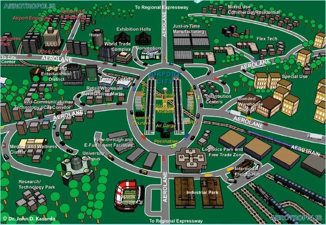
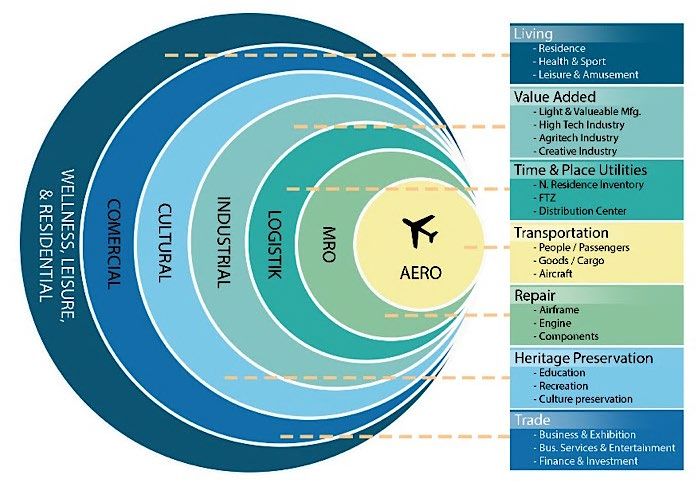
3652 T. Judiantono et al.

1. Introduction
At first the airport was only one of the transportation infrastructures to support
urban activities [1]. Airports are viewed only as places where airplanes operate with
standard equipment in the form of runways, taxi ways, aircraft parking runways
(apron), control towers, passenger and freight terminal buildings, hangars, and
other facilities that are directly related to and to serve aircraft, passengers, and cargo
[2]. However, along with the development of regional and global economic
relations, the role of airports has changed drastically; they are no longer just as
accessories for city infrastructure, but they have developed into an economic
driving force for urban activities [3], as shown by the successful development of
airport cities and aerotropolises in several countries which managed to improve the
city's economy by utilizing the potential of airports in the region [4-6].
 Along with the development of the airport, airport revenues no longer depend
on aeronautical revenues but are mostly obtained from non-aeronautical
businesses. For some aerotropolises, these non-aeronautical activity centres
already exist and develop first in the city or area around the airport. However,
this is not the case for the new aerotropolis, the new non-aeronautical activities
are indeed designed and placed in the area around the airport (see Fig. 1) [7, 8].
Almost all aerotropolises that are developing successfully today are generally
airports in mainland and are located on the outskirts of metropolitan cities [9].
There are also aerotropolis airports that are developing on small islands, such as
in Hong Kong, but this Hong Kong international airport is located close to the
mainland and is connected to activity centres on the mainland through land
transportation infrastructure and support for qualified information technology,
thus enabling its development. become an aerotropolis. Then what about airports
located on small islands far from the mainland and minimal or undeveloped non-
aeronautical business activities as supporters.
 This condition is faced by HNA (Hang Nadim Airport) which is located on
Batam Island with a limited area, far from the mainland of Sumatra Island and non-
aeronautical business activities are still limited. For HNA airport and Batam city,
expansion efforts by building the Barelang bridge that connects Batam island with
the surrounding small islands (Batam Island, Rempang Island, Galang Island) have
not shown significant progress when measured from the employment indicator) and
income [10] even though HNA is one of the largest airports in Indonesia with a
Run-way (45m x 4,025m) and has been designated as a Cargo Hub airport based
on the Decree of the Minister of Transportation of the Republic of Indonesia
No.166/2019 [11].
 Inspired by what was conveyed by Kasarda [12], Peoples [13], Kazda et al. [14]
and Button et al. [15] that the size of the airport is not a problem to develop into an
aerotropolis, as long as regional accessibility to activity centres can be increased,
making the aerotropolis an economic magnet [16, 17]. This manuscript tries to
provide an analysis of the possibility of a public airport located on a small island
that is far from the mainland and minimal support for non-aeronautical activities,
such as this HNA, being developed into an aerotropolis through the expansion of
hinterland coverage and integration of non-aeronautical business activities that are
far apart. Its location but its activities are still tied to the HNA airport. Airport city
diagram and business activity inside airport area can be seen in Fig. 2.

Journal of Engineering Science and Technology October 2021, Vol. 16(5)
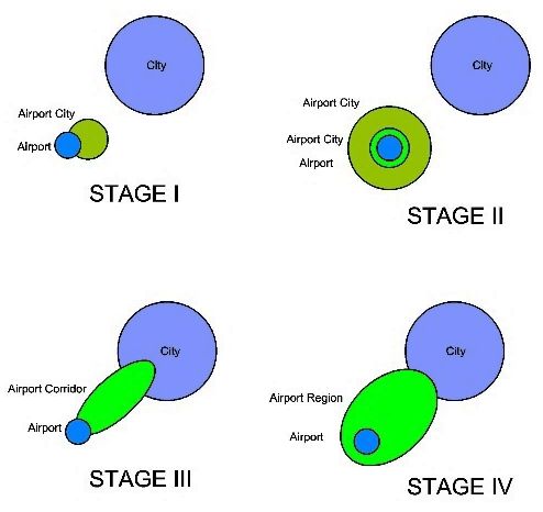
Analysis of Aerotropolis in Small Islands 3653

 Fig. 1. A spatial compressed model of the aerotropolis [18].

 Fig. 2. Airport city diagram and business activity inside airport area.

 An aerotropolis is an urban form whose layout, infrastructure, and economy are
centered on airport. Aerotropolis offers its business with the connectivity and speed
offered to suppliers, customers, and partner companies worldwide [18]. The shape
of the aerotropolis is analogous to a traditional metropolis consisting of a city center
and a circle of commuter suburbs. The aerotropolis consists of the airport city center
and the corridors connecting it with business groups related to aviation and
residential developments (see Fig. 1). The development from a public airport to an
aerotropolis airport can be seen in Fig. 3 [19]. For airports located on the mainland,
development into an aerotropolis can follow the Fig. 3 scheme, but for airports
located on islands, with limited land area and minimal support for business
activities such as HNA, of course, they cannot follow the development scheme as
shown in Fig. 3. Studies on aerotropolis have been widely conducted [13, 20-23];
however, ones focusing on small islands, especially ones far from the mainland, are

Journal of Engineering Science and Technology October 2021, Vol. 16(5)
3654 T. Judiantono et al.

very limited. Therefore, this study focuses on analysing aerotropolis in small
islands in Indonesia.

 Fig. 3. Schematic of airport development into aerotropolis.

2. Research Methods
2.1. Research site
Hang Nadim Airport (HNA) is located in Batam City, Riau Islands Province,
Indonesia. This airport is one of the 11 cargo airports (hub) and the only hub airport
in Indonesia which is located on a relatively small island in area. Batam city area
is 159,500 Ha or 1,595 Km2, with a land area of 960 Km2. The population of Batam
City in 2019 was 1,157,882 people, with a density of 1,206 Org/Km2. This airport
is managed by BUBU-BP Batam (Airport Business Entity-Batam Business
Entity/Airport Business Unit of Batam Authority); thus, it is included in the FTZ
(Free Trade Zone) Batam. As one of the largest airports in Indonesia, with an area
of 1,762 hectares, this airport has a Runway of 45m x 4,025m, making it eligible to
serve wide-body aircraft in the B-747 class. The passenger movement service
capacity in 2019 is 5 million passengers per year, cargo loading and unloading
service capacity is 50,000 tons per year, and aircraft movement service capacity is
around 30,000 aircraft per year. Meanwhile, 2018 data shows that the number of
passengers served at HNA airport is 5,159,833 passengers, 56,891,232 kg or more
than 56 thousand tons of cargo and 42,008 aircraft movements. The data also shows
that in the 2013-2018 period, passenger traffic flow at HNA airport grew by an
average of 7.83%, freight traffic (cargo) increased by an average of 5.2% and
aircraft movements at the airport increased by an average growth of 7.59%. Thus,
if assessing this condition, HNA airport is urgent to be developed immediately. The
question is can it be developed into an aerotropolis?

2.2. Data collection
This research utilizes secondary data from 2009-2019 sourced from BUBU-BP
Batam. The data used are airport facilities data, airport development plan data,
aircraft movement data, passengers and cargo which can be obtained directly from
BUBU-BP Batam. In addition, supporting data were also obtained from the BPS
(Central Bureau of Statistics/ Statistics Office) Batam City, BPS Riau Islands

Journal of Engineering Science and Technology October 2021, Vol. 16(5)
Analysis of Aerotropolis in Small Islands 3655

Province and the National BPS for population and economic data
(https://www.bps.go.id). Meanwhile, to find out airport facilities data, airport
development plan data, aircraft, passenger, and cargo movement data at all airports
in Indonesia, and data from the 2019-2024 Air Transportation Strategic Plan,
obtained from Air Transportation Statistics on the Ministry of Transportation
website of the Republic of Indonesia (https://sisfoangud .dephub.go.id).

2.3. Data analysis
The data obtained were then analysed to determine the condition of core
aeronautical activities, relation to airfreight or air-passenger movements, and
airport-oriented activities choose the airport area [19] as a step to assess whether
the public airport can be developed into an aerotropolis.
 To assess the core aeronautical activities, there are 7 (seven) aspects that must
be met so that an airport and the surrounding area can develop into an aerotropolis
[24], namely:
 • Active airport: The airport is an active airport with high activity intensity
 • Land availability: Availability of land for the development of airport city
 (Airport City) and airport urban (Aerotropolis)
 • Connectivity with hinterland: The airport has good connectivity with space
 components inside and outside the airport area
 • Socio-economic support from the community: The existence and
 development plan are supported by the socio-economic structure of the
 community around the airport
 • Institutional support: The development plan has institutional support and
 cooperation, both from the government and the private sector
 • Development planning collaboration: Have an integrated development
 planning and development strategy, across institutions, both at the strata and
 the depth of planning
 • Innovative management: Having innovative management institutions/
 organizations for airport cities and airport cities.
 Thus, as the first step, the 7 aspects are used to assess the readiness of an airport
to become an airport city or an airport city with the parameters and sub-parameters
of the assessment as shown in Table 1 [19].

 Table 1. Weight parameter reference rate on determining value.
 Weights Weight Sub Score
 ASPECT
Parameter Parameter (S)
 1. Active Airport Aspects and High Activity Intensity
 0,3 1.1. Airport Operations Infrastructure
 0,4 1.1.1. Service Facilities Air Side 3
 0,3 1.1.2. Service Landside Facility 5
 0,3 1.1.3. Operational Support Facility Service 3
 0,3 1.2. Airport Operational Activities
 0,3 1.2.1. Airport Service Capacity 5
 0,3 1.2.2. Flight Route 1
 0,2 1.2.3. Aviation Operations 3
 0,2 1.2.4. Aerodrome Traffic Controller 1
 0,2 1.3. Airport Certification
 0,3 1.3.1. Directorate General of Transportation and Aviation 5
 0,2 1.3.2. Federal Aviation Administration (FAA) 5

Journal of Engineering Science and Technology October 2021, Vol. 16(5)
3656 T. Judiantono et al.

 0,3 1.3.3. International Civil Aviation Organization (ICAO) 5
 0,2 1.3.4. International Air Transport Association (IATA) 5
 0,2 1.4. Feasibility of Aviation Operation
 0,2 1.4.1. Air Traffic Management Authority 1
 0,6 1.4.2. Aviation Operation Safety Area ( KKOP) 5
 0,2 1.4.3. Noise Area Boundaries (BKK) 1
 2. Aspects of Land Availability for Airport Development
 0,4 2.1. In Kaw Airport for Aeronautical activities at Airport Center
 0,3 2.1.1. Development of Airside Facilities 5
 2.1.2. Development of Landside Facilities for Passenger Terminal
 0,2 5
 Buildings
 0,3 2.1.3. Development of Cargo Terminal Facilities 5
 0,2 2.1.4. Development of Airport Operational Support Facilities 5
 2.2. Within the Airport Area for Non-Aeronautical Activities at Airport
 0,3
 City
 0,2 2.2.1. Development of Free Trade Areas 5
 0,1 2.2.2. Development of Industrial and Technological Zones 5
 0,1 2.2.3. Urban Tourism and Cultural Arts Area Development 3
 0,1 2.2.4. Health and Wellness Center Area 3
 0,2 2.2.5. Research and Higher Education Center Area 3
 0,05 2.2.6. Green and Parks Area 3
 0,2 2.2.7. Development of Local Multi-Moda Nodes (Inland Zone) 5
 0,05 2.2.8. Development of Basic Infrastructure/Utilities of the City 5
 0,2 2.3. Outside the Airport Kaw for Non-Aeronautical Activities
 0,2 2.3.1. Development Plan for Free Trade and Special Economic Zones 5
 0,1 2.3.2. Regional Development Plan Logistics and Warehousing 5
 0,1 2.3.3. Industrial and Technological Zone Development Plan 5
 0,1 2.3.4. International Convention and Business Area Development Plan 5
 0,1 2.3.5. Tourism Area Development Plan 5
 0,05 2.3.6. Development Plan Transit Residential Area Residential Area 5
 0,05 2.3.7. Health and Wellness Area Development Plan 3
 0,05 2.3.8. Research and Higher Education Center Area Development Plan 5
 0,1 2.3.9. Development Plan 3
 0,05 2.3.10. Plan Infrastructure Development Lok Multi moda 5
 0,05 2.3.11. Green Area and Parks Development Plan 3
 0,05 2.3.12. Basic Infrastructure/Utilities Development Plan 5
 0,1 2.4. Outside the Airport Kaw for Non-Aeronautics in Outland
 0,2 2.4.1. Free Trade and Special Economic Zone Development Plan 5
 0,1 2.4.2. Logistics and Warehousing Zone Development Plan 5
 0,1 2.4.3. Industrial and Technological Zone Development Plan 3
 0,1 2.4.4. International Convention and Business District Development Plan 3
 0,05 2.4.5. Tourism Area Development Plan 5
 0,1 2.4.6. Transit Shelter Development Plan 3
 0,1 2.4.7. Health and Wellness Area Development Plan 3
 0,1 2.4.8. Research and Education Center Area Development Plan High 3
 0,05 2.4.9. Settlement Development Plan Multimodal 5
 0,05 2.4.10. Regional Infrastructure Development Plan 3
 0,05 2.4.11. Business Zone Development Plan and International Convention 5
 3. Aspects of Connectivity Between Inside and Outside Space
 Components Airport City and Airport Urban
 0,2 3.1. Aeroplane in the Island and Surrounding Islands
 0,1 3.2. Aerotrain in the Island and Surrounding Islands
 0,1 3.3. Sea Lane in the Island and Surrounding
 0,1 3.4. Cargo Sea Lane in the Island and Areas Surrounding Islands
 0,1 3.5. Domestic Airport Passenger in the Archipelago/Hinterland
 0,1 3.6. International Airport Passenger in the Archipelago/Hinterland
 0,1 3.7. Cargo Airport in the Archipelago/Hinterland Area
 0,1 3.8. International Airport Pass sanger
 0,1 3.9. International Airport Cargo
 4. Community Socio-Economic Structure Support for Airport City and
 Airport Urban
 0,3 4.1. Social Structure Support in Island Areas
 0,3 4.1.1. Existence of Settlement Areas 5
 0,2 4.1.2. Existence of Institutions Education 5
 0,2 4.1.3. Existence of Research and Development Institutions 3
 0,1 4.1.4. Existence of Transit Residential Areas 1
 0,2 4.1.5. Existence of Health and Wellness Facilities 1
 0,3 4.2. Supporting Economic Structures in Island Areas
 0,3 4.2.1. Existence of Free Trade and Special Economic Zones 5
 0,3 4.2.2. Existence of Logistics and Warehousing Zones 5
 0,2 4.2.3. Existence of Industrial and Technological Zones 5
 0,1 4.2.4. Existence of Business Zones and International Conventions 5
 0,1 4.2.5. Presence Tourism Region 5

Journal of Engineering Science and Technology October 2021, Vol. 16(5)
Analysis of Aerotropolis in Small Islands 3657

 0,2 4.3. Support of Social Structure in the Outer Island Region
 0,2 4.3.1. Settlement Region Presence 3
 0,2 4.3.2. Presence Institutions 3
 0,2 4.3.3. Presence and Research Institute Development 3
 0,2 4.3.4. Existence of Residential Area 5
 0,2 4.3.5. The existence of Area Development Health and Fitness 3
 0,2 4.4. Outside Support Regional Economic Structure Island
 0,3 4.4.1. Presence Free Trade Zone in the Outer Island Region 3
 0,2 4.4.2. The existence of Logistics and Warehousing 3
 0,2 4.4.3. Existence of Industrial and Technological Areas 1
 0,1 4.4.4. Existence of Business Zones and International Conventions 1
 0,1 4.4.5. Existence of Tourism Areas 3
 0,1 4.4.6. Existence of Production Areas 3
 5. Aspects Institutional Framework and Public-Private Cooperation
 0,3 5.1. Government Institutions
 0,5 5.1.1. Regional Government 5
 0,3 5.1.2. Provincial Government 5
 0,2 5.1.3. Central Government 5
 0,7 5.2. Institutional Authority
 0,6 5.2.1. Enterprises 5
 0,4 5.2.2. Business Entities 5
 6. Integration Aspects of Development Planning and Development
 Strategies
 0,1 6.1. Plans at the International Level
 0,5 6.1.1. Global Cooperation Plans 1
 0,5 6.1.2. Cooperation Plans Regional 1
 0,1 6.2. Plans at the National Level
 0,3 6.2.1. Regional Spatial Plans N original 1
 0,7 6.2.2. National Strategic Plans 1
 0,1 6.3. Regional Plans
 0,3 6.3.1. Provincial Spatial Plans 1
 0,7 6.3.2. Regional Strategic Plans 1
 0,2 6.4. Regional Environmental Plans Airport Work (DLKR)
 0,2 6.4.1. Development Plans for Areas Inside the Airport Center 1
 0,8 6.4.2. Developments in Airport City Areas in Airport Areas 1
 0,2 6.5. Plans at the Regional Level of Airport Influence (DLKP)
 0,9 6.5.1. Planning at the Aerotropolis on the Island (Land Base) 1
 0,1 6.5.2. Planning at the Aerotropolis in the Island (Land Base) 1
 0,3 Planning at the Archipelago (Aviation Base)
 1 Planning Aerotropolis outside the Island (Aviation Base) 1
 7. Preparation of Innovative Airport City and Airport Urban
 Management Institutions
 0,3 7.1. Global Market Innovations
 1 7.1.1. Global Market Development 1
 0,4 7.2. End to End Services Innovation
 0,4 7.2.1. Improved Connectivity 1
 0,3 7.2.2. Improved Service Speed 1
 0,3 7.2.3. Pe Improved Service Flexibility 1
 0,3 7.3. Aerotropolis Center Infrastructure Innovation
 0,3 7.3.1. Aeronautical Infrastructure Innovation 1
 0,7 7.3.2. Non-Aeronautical Infrastructure Innovation 1

Reference Score: High (5), Fairly high (4), Medium (3), Somewhat low (2) and Low (1)
 The 7 (seven) aspects are rated based on the degree of importance of one to the
other. The value of each aspect is obtained through the following formula:

 = ∑( × ) (1)
 = ℎ × ℎ (2)
Where TN is the total score; TB is the total weight; and S is the score.
 As a reference, the comparative value of 4 (four) airport cities and
aerotropolises that have successfully developed (Schipol, Incheon, Soongdo and
Dubai) is used, as can be seen in Table 2 [19].

Journal of Engineering Science and Technology October 2021, Vol. 16(5)
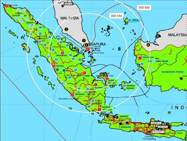
3658 T. Judiantono et al.

 Table 2. Basis of reference value of 4 (four)
 aerotropolises that are successfully developing.
 No Aspect Average
 1 Active Airport 0,175
 2 Land Availability 0,2
 3 Connectivity with hinterland 0,0125
 4 Community Socio-Economic 0,075
 5 Support Institutional Support 0,075
 6 Development Planning Collaboration 0,1
 7 Management Innovative 0,25

 The next step is to assess relation to airfreight or air-passenger movements.
This step is to assess the potential for movement of passengers and goods, both
land-based and air-based. Potential existing conditions and predictions are based
on estimates of the generation of passenger and goods movements as well as the
potential for land-based and air-based commodities. In this study, the coverage
of the hinterland aerobase area is set for 1 hour of small aircraft flight. This 1-
hour air travel time is adjusted to the distance, the hinterland land-based radius
of 20 miles (32 km) which is commonly used as a reference for the coverage of
the aerotropolis [25], or 1 hour road trip. Based on the land-based, HNA (Hang
Nadim Airport) only covers 1 province of the Riau Islands and 2 airports (HNA
and Bintan) with 2.189 million inhabitants (see Fig. 4), while the aerobase will
cover 11 provinces with 53 operational domestic airports that can be connected,
and 63,623 million people (see Fig. 5). Data on the movement of aircraft,
passengers and goods for the last 10 years (2009-2019) were obtained from the
Indonesian Air Transportation Statistics data, while population and GRDP (Gross
Regional Domestic Product) data were obtained from BPS, as well as commodity
potential data from hinterland aerobase areas obtained from BPS which selected
through the analysis of LQ (Location Quotient) in order to obtain a number of
superior commodities for each hinterland such as the potential for tourism,
agriculture, livestock, fisheries and industry. All data is then processed using
SPSS-Statistic-21 to predict the potential movement up to 20 years.

 Fig. 4. Coverage map of golf court and tourism object in Batam.

Journal of Engineering Science and Technology October 2021, Vol. 16(5)
Analysis of Aerotropolis in Small Islands 3659

 Fig. 5. Coverage map of 1 hour flight from
 HNA by small and narrow body aircraft.

2.4. Location quotient analysis
To select potential commodities in the hinterland area, Location Quotient (LQ)
analysis will be used. LQ is an analysis used to determine the degree of specialization
of economic sectors in an area that utilizes the base sector or the leading sector.
Location quotient calculates the comparison of sector output share (i) in the city or
district and sector share out (i) in the province. The leading sector here means the
business sector that will not run out if exploited by the regional government.
 The LQ mathematical formula that is commonly used to compare the
capabilities of the sectors of the region is as follows [26]:

 ⁄
 = (3)
 ⁄

where Y is the region; V is the sub region of Y (observed); Vi is the value of product
Z sector (i) in sub region V (observed); Vt is the total value of sector (i) in sub region
V (observed); Yi is the value product Z sector (i) in region Y; and Yt is the total value
of sector (i) in region Y.
 If the results of the above formulation produce:
 • LQ > 1 means that the commodity is the basis or source of growth.
 Commodities have a comparative advantage; the results can not only meet
 the needs of the region concerned but can also be exported outside the region.
 • LQ = 1 means that the commodity is classified as non-basic, does not have a
 comparative advantage. Its production is only sufficient to meet the needs of
 its own region and cannot be exported.
 • LQ < 1 means, this commodity is also a non-base. Commodity production in an
 area cannot meet its own needs so it needs to be supplied or imported from outside.

Journal of Engineering Science and Technology October 2021, Vol. 16(5)
3660 T. Judiantono et al.

 The next step as a closing step is to assess the airport-oriented activities choose
the airport area, which is to assess the level of accessibility of the movement of
passengers and goods, both land-based and land-based. air (aero base). For land-base,
accessibility to HNA airport is seen from the availability of road network in the city,
both existing and planned in the RTRW (Regional Spatial Plan/Masterplan) of Batam
City, while aerobase accessibility is seen from the number of existing flight route
links and potential flight route links that can be used. opened according to the scope
of the aerobase. There are currently 18 links (15 DN and 3 LN) with 13 operators (11
DN and 2 LN), and a potential of 53 new domestic flight routes that can be opened.
All steps of this research can be seen in Fig. 6.

 Fig. 6. Research steps.

3. Results and Discussion
3.1. Stage-1
The results of the analysis of HNA values for 7 aspects of the requirements for public
airports to be developed into an airport city or aerotropolis are shown in Table 3.

 Table 3. Weights of reference values for the
 Hang Nadim-Batam Airport city and aerotropolis development plan.
 No Main Aspects of BA
 1 Aspects of Active Airports and High Activity Intensity 0,1
 2 Aspects of Land Availability for Airport City and Airport Urban Development 0,2
 Aspects of Connectivity Between Components Space Inside and Outside Airport
 3 0,1
 City and Airport Urban
 Support of Community Socio-Economic Structure to Airport City and Airport
 4 0,05
 Urban
 5 Institutional Framework and Public-Private Cooperation 0,05
 6 Integration of Development Planning and Development Strategy 0,1
 7 Setting Up Innovative Airport City and Airport Urban Management Institutions 0,4

 When compared with Table 2, the results of the HNA assessment show that all
aspects have been met, except for the 1st aspect regarding active airports and high
activity intensity, HNA is considered to be still lacking; therefore, efforts need to be

Journal of Engineering Science and Technology October 2021, Vol. 16(5)
Analysis of Aerotropolis in Small Islands 3661

 made to increase the number of aircraft, passenger, and cargo movements, through
 expansion hinterland coverage and also the addition of flight service facilities.

 3.2. Stage-2
 Table 4 shows that there are 11 provinces in the Sumatra Island and Kalimantan
 Island, with 83 airports within the region. The capacity of the 83 airports varies
 greatly from category II/Dom to category IV/Intl. The maximum types of aircraft
 that can be served also vary, ranging from ATR-42, ATR-72 (Small Aircraft), B737
 (Narrow Body Aircraft) to B767 (Wide Body Aircraft). HNA belongs to category
 IV/Intl and can serve B767, so there are no obstacles to serving the type of aircraft
 below, both passenger and cargo planes. Of the 83 airports, until 2019 there are 53
 airports that are operational and capable of serving ATR-42 class aircraft. Through
 the travel time approach, within a 1-hour flight radius from HNA using small
 aircraft or the equivalent of 500 Km, there are 23 airports in 6 provinces out of 11
 provinces that have the potential to become hinterlands from HNA, while if using
 medium aircraft (Narrow body aircraft) where 1-hour flight is equivalent to 800
 Km will cover 22 airports in 10 provinces out of 11 provinces that can become
 hinterlands. Data on airport capacity and commodity potential from each location
 can be seen in Table 4.

 Table 4. Airports in Sumatra and Kalimantan
 have the potential to be hinterland HNA.
No Airport Code CAT CA Distance Potential
 DI Aceh Province
1 S Iskandar Muda (B. Aceh ) BTJ/WITT IV/Intl B737 1.082.29 Wis/Tan/Tek/Ind
2 Maimun Saleh (Sabang) SBG/WIAA II/Dom ATR-72 1.107,48 Wis
3 Malikussaleh (LSeumawe) LAW/WITM III/Dom B737 917,55 Tan/Tek/Ind
4 Landeng (Lhoksukon) LSX/WITL II/Dom ATR-72 878,77 Tan/Tek/Ind
5 Rembele Airport III/Dom B737 900,81 Tan/Tek/Ind
6 C.Nyak Dhien (Meulaboh) III/Intl B737 931,81 Wis/Tan/ Ind
7 Alas Leuser (Gayo Alas) II/Dom ATR-42 738,87 Tan/ Wis
8 Pati Ambang MEQ/WITC II/Dom ATR-42 813,69 Tan/Tek/Ind
9 Lasikin (Blangpidie) ALS/WILD III/Dom B737 877,81 Wis/Tan
 TPK /WITA
10 Syekh H Fansyuri (Singkil) III 863,63 Tan/Tek/Ind
 TXE WITK
11 T.Cut Ali (Tapaktuan) 695,59 Wis/Tan/Tek/Ind
12 Takengon Aceh
 North Sumatera Province
1 Kualanamu (D Serdang) KNO/WIMM IV/Intl B767 645, 75 Wis/Tan/Tek/Ind
2 Silangit (Siborong2) SQT/WIMN III/Dom B737 584, 19 Wis/Tan
3 FL Tobing (Sibolga) FLZ/WIMS III/Intl B737 582,44 Wis/Tan/Tek
4 Binaka (G.Sitoli/Nias) GNS/WIMB II/Dom ATR-72 712,85 Wis/Tan
5 Sibisa (Parapat) SIW/WIMP III/Dom B737 595 88 Wis/Tan/
6 Aek nabara (RPrapat) II/Dom ATR-72 475, 88 Wis/Tan
7 Aek Godang (PSidempuan) AEG/WIME II/Dom ATR-72 791, 88 Wis/Tan Ind
8 Lasondre (P.Tanah Masa) MES/WIMM II/Dom ATR-72 658, 82 Wis/Tan/
9 Soewondo (Polonia) Mil DC-3 DC-3 497,66 Tan/Tek/Ind
10 Helvetia (Medan) - - - 658, 82 Tan/ Ind
11 Helipad Pemping - - - 662,99 Tan
 Kepulauan Riau Province
1 Hang Nadim BTH/WIDD IV/Intl B767 0 Wis/Tan/Tek/Ind
2 RH. Fisabilillah (Bintan) TNJ/WIDN III/Intl B737 2 Wis/Tan/Tek/Ind
3 Ranai (Natuna) NTX/WION III/Intl B737 3 Wis /Tek/Ind
4 Letung (Pulau Jemaja) II/Dom B737 274,3 Wis/Tan
5 Matak (Pulau matak) MW/WIOM III/Dom B737 343, 26 Wis/Tek
6 RH.Abdullah (T Balai K) II/Dom ATR-72 6 Wis /Tek/Ind

 Journal of Engineering Science and Technology October 2021, Vol. 16(5)
3662 T. Judiantono et al.

7 Bintan Res (Bintan) II/Dom ATR-72 7 Wis
8 Dabo (Singkep) III/Dom B737 185,03 Wis/Tan/
9 Sei Bati TJB/WIBT III/Dom B737 89.30.00 Wis /Tek/Ind
 Riau Province
1 Sultan S Kasim II (Pku) PKU/WIPP IV /Intl B737 436,78 Wis/Tan/Tek/Ind
2 Pinang Kampai (Dumai) DUM/WIB III/Dom B737 303,42 Tan/Tek/Ind
3 Sei Selari (Sei Pakning) SEQ/WIBS II/Dom ATR-72 221,65 Tan/ Ind
4 T Tambusai (Pasir P) PPR/WIDE II/Dom ATR-72 418,165 Tan /Ind
5 Japura (Rengat) RGT/WIPR II/Dom ATR-72 257,43 Tan/ Ind
6 Tempuling (Tembilahan) - II/Dom ATR-72 212,71 Tan/ Ind
7 Sultan S Harun (Plwn) - II/Dom ATR-72 252,13 Tan/Ind
 West Sumatera Province
1 Minangkabau (Padang) PDG/WIPT IV/Intl B737 476,4 Wis/Tan/Tek/Ind
2 Pusako Anak N (Ps Barat) PSQ/WIPP II/Dom ATR-72 495,29 Wis/Tan
3 Labuhan (Batu sangkar) BSR/WIPQ II/Dom ATR-42 - Wis/Tan
4 Rokot (Sipora) RKO/WIBR III/Dom ATR-72 607,43 Wis/Tan
5 Miangas (Pagai Selatan) MQE/WIIB II/Dom ATR-72 - Wis
6 Piobang (Payakumbuh) MIL Mil DC-3 - Wis/Tan
7 Wilmar (Sungai Dareh) - II/Dom ATR-42 - Tan
 Bengkulu Province
1 Fatmawati S (Bengkulu) BKS/WIPL IV/Intl B737 588,032 Wis/Tan/Tek/Ind
2 Mukomuko (Mukomuko) MPC/WIPU II/Dom ATR-42 528,154 Wis/Tan/Tek/Ind
3 Enggano (Enggano) - II/Dom ATR-42 567,88 Wis/Tan/Tek/Ind
 Jambi Province
1 Sultan Thaha (Jambi) DJB/WIPA IV/Intl B737 310,69 Wis/Tan/Tek/Ind
2 Muara Bungo (M Bungo) BUU/WIPI II/Dom ATR-42 366, 28 Tan/Tek/Ind
3 Depati Parbo (S Penuh) SPH/WIPF III/Dom ATR-72 463,26 Wis/Tan
 South Sumatera Province
1 St Badaruddin II(Plmbang) PLM/WIPP IV/Intl B737 451,4 Wis/Tan/Tek/Ind
2 Pendopo (Pendopo) PDO/WIPQ II/Dom ATR-72 490,91 Wis/Tan/
3 Silampari (Lb Linggau) LLGWIPB III/Dom ATR-72 507,69 Wis/Tan/Tek
4 Atung Bungsu (Pg Alam) PXA/WIOP II/Dom ATR-72 577,7 Wis/Tan/
5 Gatot Subroto MIL MIL DC-3 527,53 Tek/Ind
6 Helipad - - - 516,85 Wis/Tan/Tek/Ind
 Bangka Belitung Province
1 Depati Amir (P Pinang) PGK/WIKK III/Intl B737 428, 63 Wis Tek/Ind
2 HAS Hanandjoedin (Bel) TJQ WIKT III/Intl B737 591,09 Wis/Tan
 Provinsi Lampung
1 Rd Inten II (BLampung) TKG/WICT III/Intl B737 717,42 Wis/Tan/Tek/Ind
2 M Taufiq Kiemas (Krui) KRW/WICC III/Dom B737 613,54 Wis/Tan/Ind
3 Astra Ksetra Lampung AKQ/WIAG II/Dom ATR-42 704,6 Tan/Tek
 West Kalimantan Province
1 Supadio (Pontianak) PNK/WIOO IV/Intl B737 604,36 Wis/Tan/Tek/Ind
2 Tebelian (Sintang) SQG/WIOS II/Dom ATR-72 825,98 Wis/Tan/Tek
3 Nanga Pinoh (Na Pinoh) NAM/WAPR II/Dom ATR-72 863,8 Wis/Tan
4 Pangsuma (Putussibau) PSY/WIOP II/Dom ATR-72 980,68 Wis/Tan/Ind
5 Rahadi Oesman (Ktpang) KTQ/WIOK III/Dom B737 727,53 Wis/Tan/Ind
6 Helipad BD sejahtera - - - 616,85 Tan

 Wis = Tourism, Ind = Industry, Tek = Livestock, Tan = Agriculture (including
 Fisheries/sea products)

 The potential column in Table 4 is the result of LQ analysis from BPS 2020
 commodity data. All products in Table 4, namely tourism, industry, livestock, and
 agriculture (especially marine products) are expected to be accessible through the
 HNA airport with an increase in HNA hinterland coverage from the original land-
 base to aero base, namely by increasing the number of flight routes connecting
 HNA with all airports in its hinterland. If this can be done, then a number of
 business activities can be developed in HNA, as shown in Table 5. New economic
 activities that can be developed in HNA form a bond of activity as stated in
 aerotropolis concept [18].

 Journal of Engineering Science and Technology October 2021, Vol. 16(5)
Analysis of Aerotropolis in Small Islands 3663

 Table 5. Economic activity concept at Hang Nadim Airport.
 Zone Business Activity
 Aero Park Passenger Service
 Cargo Service
 Aircraft Service
 MRO MRO
 Logistics Park Warehouse
 Light Manufacturing
 Distribution Center
 Intermodal
 Integrator
 Non-Integrator
 Commercial Park Commercial
 Horeca
 Offices
 Industrial Park Light Industry
 Creative Industry

 If the travel time is increased to 2 hours using a small aircraft, then HNA will
be connected to 53 operational airports in 11 provinces in the Sumatera and
Kalimantan Islands. If this is well executed, there will be a strong economic
accumulation, from initially only serving Batam and its surroundings (Riau Islands)
with 2.189 million inhabitants, jumping to 11 provinces with 63,623 million
inhabitants, as shown in Table 6.
 Table 6. Population in HNA hinterland (Thousands of people).
 No Province 2015 2016 2017 2018 2019
 1 Aceh 5.002 5.096 5.189 5.281 5.371
 2 Sumatera Utara 13.937 14.102 14.262 14.415 14.562
 3 Sumatera Barat 5.196 5.259 5.321 5.382 5.441
 4 Riau 6.344 6.501 6.657 6.814 6.971
 5 Jambi 3.402 3.458 3.515 3.570 3.624
 6 Sumatera Selatan 8.052 8.160 8.267 8.370 8.470
 7 Bengkulu 1.874 1.904 1.934 1.963 1.991
 8 Lampung 8.117 8.205 8.289 8.370 8.447
 9 Kep. Bangka Belitung 1.372 1.401 1.430 1.459 1.488
 10 Kep. Riau 1.973 2.028 2.082 2.136 2.189
 11 Kalimantan Barat 4.789 4.861 4.932 5.001 5.069
 Total 60.058 60.975 61.878 62.761 63.623

 Likewise, from an economic perspective, with the connection of Batam (Riau
Islands) with 11 provinces in hinterland, there will be an accumulation of spikes in
the value of regional GRDP from 182 trillion rupiah (Riau Archipelago GRDP,
2019) to 2,468.7 trillion rupiah (11 provinces in 2017) as shown in Table 7.

 Table 7. PDRB at current prices (billions of rupiah).
 No Province 2015 2016 2017 2018 2019
 1 Aceh 112.666 116.374 121.241 126.824 132.087
 2 Sumatera Utara 440.956 463.775 487.531 512.766 539.527
 3 Sumatera Barat 140.719 148.134 155.984 164.034 172.321
 4 Riau 448.992 458.760 470.984 482.158 495.864
 5 Jambi 125.087 130.501 136.502 142.968 149.265
 6 Sumatera Selatan 254.045 266.857 281.571 298.570 315.623
 7 Bengkulu 38.066 40.077 42.074 44.171 46.362
 8 Lampung 199.537 209.794 220.626 232.208 244.437
 9 Kep. Bangka Belitung 45.962 47.848 49.985 52.215 53.951
 10 Kep. Riau 155.131 162.853 166.082 173.684 182.184
 11 Kalimantan Barat 112.347 118.188 124.289 130.589 137.121
 Total 2.073.508 2.163.161 2.256.869 2.360.187 2.468.742

Journal of Engineering Science and Technology October 2021, Vol. 16(5)
3664 T. Judiantono et al.

 One of the main commodities produced from 11 provinces that will become
hinterlands of HNA is marine fish, as shown in Table 8. Marine fish production
from this area in 2019 reached 2,093,229 tons or around 28.56% of Indonesia's
national marine fish production. . If only 5% of the total marine fish production is
exported through HNA, then the current HNA cargo capacity has been exceeded.
The increase in cargo services as a driver to the aerotropolis is in line with the
opinion of Kasarda [27], Appold and Kasarda [28] and Grimme et al. [9].

 Table 8. Marine fish production in the hinterland (tons).
 Province 2015 2016 2017 2018 2019
 Aceh 173.034 189.261 236.061,03 288.033,96 234.832
 Bengkulu 62.291 62.426 65.754,74 67.299,18 72.529
 Jambi 43.204 47.134 44.409,52 45.608,99 52.183
 Kepulauan Bangka
 139.633 189.967 217.912,22 228.524,74 222.140
 Belitung
 Kepulauan Riau 149.745 151.215 112.432,61 100.940,36 150.679
 Lampung 163.384 164.420 172.276,77 136.750,03 182.067
 Riau 105.298 102.101 107.843,14 120.021,67 123.443
 Sumatera Barat 204.771 200.610 214.144,00 211.821,21 238.670
 Sumatera Selatan 61.392,3 69.583 95.295,60 103.602,66 84.840
 Sumatera Utara 494.724 475.638 715.442,03 368.529,74 581.293
 Kalimantan Barat 136.301 113.430 128.207,88 112.003,95 150.553
 Total 1.733.777 1.765.785 2.109.780 1.783.136 2.093.229
 National 6.204.668 6.115.469 6.603.631 7.300.000,00 7.329.381

3.3. Stage-3
Until 2019 there are 13 Operators (11 Domestic and 2 Foreign) with 18 flight routes
(15 Domestic and 3 Overseas) connecting HNA with various cities in Indonesia
and abroad, as shown in Table 9.

 Table 9. Name of airline and flight route at Hang Nadim Airport.
 Name of Name of Airline/Operator
 Airline/Operator
 Garuda Cengkareng, Kualanamu, Tanjung Karang, Pekanbaru
 Citilink Kualanamu, Palembang, Padang, Pekan Baru, Subang, cengkareng
 Cengakareng, Kualanamu, Subang, Palembang, Pekanbaru, Djambi,
 Lion Air
 Balikpapan, Bandung, Padang, Jogjakarta
 Sriwijaya Air Jakarta, Jambi, Kualanamu
 Cengkareng, Palembang, Padang, Bandar Lampung, Subang, Kualanamu,
 Batavia Air
 Pontianak, Jogjakarta
 Garuda Cengkareng, Kualanamu, Tanjung Karang, Pekanbaru
 Citilink Kualanamu, Palembang, Padang, Pekanbaru, Sabang, Cengkareng
 Cengakareng, Kualanamu, Subang, Palembang, Pekanbaru, Djambi,
 Lion Air
 Balikpapan, Bandung, Padang, Jogjakarta
 Sriwijaya Air Jakarta, Djambi, Kualanamu
 Cengkareng, Palembang, Padang, Bandar Lampung, Subang, Kualanamu,
 Batavia Air
 Pontianak, Jogjakarta
 Wings Air Bengkulu, Natuna (Ranai), Pangkalpinang, Silangit
 Pekanbaru, Pangkal Pinang, Pontianak, Natuna (Ranai), Palembang
 Sky
 Bandar lampung
 Firefly Subang (Malaysia)
 Smac (Cargo Flight) Singapore

 As mentioned earlier, the expansion of the scope 1 hour road trip, replaced by
1-2 hours of air travel using small aircraft (either passengers or goods) will be
carried out the addition of new routes to 53 flight routes.

Journal of Engineering Science and Technology October 2021, Vol. 16(5)
Analysis of Aerotropolis in Small Islands 3665

 Because there is a difference in capacity between the airports covered by the
hinterland aerobase and HNA airports, the addition of this route can be done in 2
ways, namely the first way by adjusting the size of the aircraft used, namely using
small aircraft that can land at all airports, for example using the ATR-42 , of course
in this case it is necessary to standardize the aircraft to be used. Such a capacity
difference is in line with the results of a study in China [29]. The second way is
through increasing the size and capacity of all related airports. For example, the
standard is for a narrow body cargo plane of the Boeing 737 type, so all airports
must have their facilities adjusted to be able to serve this type of aircraft.
 Current conditions show that the number of aircraft movements on HNA is only
2.15% of the national aircraft movements, while for passengers (2.45%), Cargo
(2.54%) and Baggage (2.70%). If the number of flight routes is increased so that
they are connected to 53 airports in the hinterland, and population and economic
growth in the region covering 11 provinces follows the current growth trend where
the average LPP (Population Growth Rate) in 11 provinces is 1.63% and The
average LPE (Economic Growth Rate) is 4.6%, it is estimated that in 2030 the
number of passenger movements in HNA will reach 27.33 million people, with the
number of aircraft movements 97,764 and in 2014 it will reach 31.76 million
people, with 263,920 aircraft movements (see Table 10). The amount in 2030 is
approximately 2.5% of Indonesia's national air transportation movement, while in
2040 it will be approximately 5% of the national air transportation movement. This
scenario is clearly higher than without hinterland expansion. This increase is clearly
very influential on improving the economy of the city of Batam as expected from
its development as an aerotropolis. In line with this, studies have proven that airport
expansion has valuable influence on the economic growth [30-32].

 Table 10. Projection of aircraft movements,
 passengers, cargo, and baggage in HNA.
 Airplane Passengers Cargo Baggage
 Year
 (Movement) (Persons) (Tons) (Tons)
 2010 27.432 3.087.709 28.811 28.304
 2011 28.368 3.199.480 30.130 27.692
 2012 31.277 3.712.251 35.190 29.877
 2013 31.255 3.754.941 22.771 29.822
 2014 36.140 2.961.469 19.487 23.382
 2015 40.424 4.830.145 37.335 38.556
 2016 48.147 5.812.502 43.170 47.465
 2017 44.762 5.687.195 48.323 47.401
 2018 42.008 5.159.833 56.891 45.087
 2019 36.018 6.389.645 40.435 23.308
 2020 54.453 6.828.938 46.960 49.563
 2025 80.626 9.219.025 58.052 56.717
 2030 97.764 11.443.510 69.206 65.900
 2035 229.733 27.329.147 160.583 156.437
 2040 263.920 31.764.442 182.673 178.994

4. Conclusion
The aerotropolis was developed through the concept of an airport as the center of
all activities, especially related to economic development, by mobilizing all the
potential of the hinterland by optimizing the movement of goods and people
through land transportation to the airport as an air transportation node to cities that
become international trade distribution center.

Journal of Engineering Science and Technology October 2021, Vol. 16(5)
3666 T. Judiantono et al.

 The basic principle is to progressively increase the movement of goods that can
be transported by air with the principles of connectivity, accessibility, speed, and
flexibility of service. However, the results of this study indicate that the
development of a public airport into an Aerotropolis airport on a small island can
still be realized when the minimum airport size and facilities are met and the
hinterland coverage expansion is carried out as the main support for airport
activities to be developed, from a land-based basis to become aviation-based
(aerobase) by building an air bridge (aerobridge) to transport people and goods
(cargo) from and to all airports in the hinterland according to the existing potential
and can be developed.
 This aerobridge is needed to replace access that was originally land-based
(roads, trains, pedestrian bridges, ferry boats) to become aviation-based (airplanes).
The choice of actions that can be taken to build this aerobridge is by standardizing
the type of aircraft that can be used to serve all existing and operating airports or
standardizing the size and airport facilities in all airports covered in the hinterland
in order to serve the type of aircraft that has been determined and will used, whether
small, medium or wide body aircraft.
 The analysis has proven that the HNA has the opportunity to become an
aerotropolis through scenarios of increasing aircraft and cargo movements, by
increasing the accessibility of air transportation to airports in its hinterland, one of
which is through cargo services for marine fish products produced by 11 provinces
in the hinterland of Batam, Indonesia.
 In the short term with limited investment for the formation of the HNA
aerotropolis, ATR-42 aircraft can be used and the expansion of hinterland coverage
through additional flight times of 1-2 hours and flight frequency from and to 53
airports in 11 provinces, while in the long term, it can be standardized for all
airports to be able to serve B737, so the transport capacity will be bigger and faster.
 It is strongly recommended that future research put more focus on both the
short-term and long-term possibilities.

References
1. Gierczak-Korzeniowska, B.; and Kowalczyk, A. (2019). The concept of the
 aerotropolis based on the development of Hong Kong International Airport.
 Geography and Tourism, 7(2), 27-39.
2. Warsito, D. (2017). Manajemen bandar udara: Landasan pacu, taxiway, dan
 apron. Jakarta: Erlangga.
3. Perera, E.D.J.; Mahanama, P.K.S.; and Gamage, P. (2019). A novel approach
 for planning an aerocity (aerotropolis) in Negombo-Katunayake Peri-Urban
 Region. International Journal of Advanced Research and Publications, 3(8),
 98-105.
4. Choi, J.H.; Wang, K.; Xia, W.; and Zhang, A. (2019). Determining factors of
 air passengers’ transfer airport choice in the Southeast Asia - North America
 market: Managerial and policy implications. Transportation Research Part A:
 Policy and Practice, 124, 203-216.
5. Lin, W.; and Ai, Q. (2020). ‘Aerial silk roads’: Airport infrastructures in
 China's belt and road initiative. Development and Change, 51(4), 1123-1145.

Journal of Engineering Science and Technology October 2021, Vol. 16(5)
Analysis of Aerotropolis in Small Islands 3667

6. Liou, J.J.H.; Hsu, C.C.; Li, C.S.J.; Pineda, P.J.G.; and Chang, G.W. (2018).
 Developing a successful aerotropolis by using a hybrid model under
 information uncertainty. Technological and Economic Development of
 Economy, 24(3), 1080-1103.
7. Banai, R. (2017). The aerotropolis: Urban sustainability perspectives from the
 regional city. Journal of Transport and Land Use, 10(1), 357-373.
8. Kasarda, J.D. (2013). Airport cities: The evolution. Retrieved June 15, 2021,
 from http://aerotropolisbusinessconcepts.aero/wp-content/uploads/2014/08/3_
 AirportCities_TheEvolution2.pdf
9. Grimme, W.; Maertens, S.; and Schröpfer, A. (2018). Options for traffic
 growth at smaller European airports under the European commission’s
 guidelines on state aid. Transportation Research Procedia, 35, 130-139.
10. Huderek-Glapska, S. (2013). The employment and income benefits of airport
 operation on the country in transition. LogForum, 9(1), 27-34.
11. Menteri Perhubungan Republik Indonesia (2019). Keputusan Menteri
 Perhubungan Republik Indonesia nomor km 166 tahun 2019 tentang tatanan
 kebandarudaraan nasional. Retrieved June 10, 2021, from http://jdih.
 dephub.go.id/assets/uudocs/kepmen/2019/KM_166_TAHUN_2019.pdf
12. Kasarda, J.D. (2007). Size doesn’t matter. Retrieved June 15, 2021, from
 http://aerotropolis.com/airportcity/wp-
 content/uploads/2018/10/2007_03_SizeDoesntMatter-1.pdf
13. Peoples, J. (2014). The economics of international airline transport vol 4.
 Bingley: Emerald Group Publishing.
14. Kazda, A.; Hromádka, M.; and Mrekaj, B. (2017). Small regional airports
 operation: Unnecessary burdens or key to regional development.
 Transportation Research Procedia, 28, 59-68.
15. Button, K.; Doh, S.; and Yuan, J. (2009). The role of small airports in economic
 development. Airport Management, 4(1), 1-12.
16. Kasarda, J.D. (2020). Aerotropolis business magnets. Retrieved June 15, 2021,
 from http://aerotropolis.com/airportcity/wp-content/uploads/2020/04/Aerotro
 polis _Magnets-1.pdf
17. Rogerson, C.M. (2018). Urban tourism, aerotropolis and local economic
 development planning: Ekurhuleni and O.R. Tambo International Airport,
 South Africa. Miscellanea Geographica, 22(3), 123-129.
18. Kasarda, J. D. (2018). China’s aerotropolis: The Zhengzhou Airport economy
 zone. Retrieved June 15, 2021, from https://www.internationalairportreview.
 com/whitepaper/73497/chinas-aerotropolis-airport-economy
19. Budiyono, W. (2020). Aerotropolis untuk pengembangan wilayah Batam dan
 sekitarnya. Bandung: Universitas Islam Bandung.
20. Charles, M.B.; Barnes, P.; Ryan, N.; and Clayton, J. (2007). Airport futures:
 Towards a critique of the aerotropolis model. Futures, 39(9), 1009-1028.
21. Syafarudin, A.; and Mulyana, B. (2019). Formulation strategy of PT. Bandara
 Internasional Jawa Barat Bandung Indonesia, Kertajati in business aerocity
 (Aerotropolis). International Review of Management and Marketing, 9(3),
 106-111.

Journal of Engineering Science and Technology October 2021, Vol. 16(5)
3668 T. Judiantono et al.

22. Yangmin, B.; Shaohong, F.; and Yan, L. (2021). Assessing the synergy and
 sustainability of “Airport-Industry-City" (AIC) system in aerotropolis:
 Evidence from Zhengzhou Aerotropolis in China. Environmental Research,
 195, 1-10.
23. Berawi, M.A.; Miraj, P.; Adhityo, A.D.; and Sakti, G.R. (2017). Improving
 regional development through aerotropolis conceptual design. Proceedings of
 the International Conference on Eco Engineering Development. Yogyakarta,
 Indonesia, 1-6.
24. Fernando, W.W.A.S.; and Bandara, J.M.S.J. (2017). Key factor analysis to be
 an airport city (Aerotropolis) in Sri Lankan context. Proceedings of the
 International Forum on Shipping, Ports and Airports: Innovative Transport
 Logistics in Shaping the Future of Supply Chains. Hong Kong, China, 17-30.
25. Alkaabi, K.A.; Debbage, K.G.; and Touq, A. (2013). The promise of the
 aerotropolis model in the United Arab Emirates: The role of spatial proximity
 and global connectivity. The Arab World Geographer, 16(3), 289-312.
26. Jumiyanti, K.R. (2018). Analisis location quotient dalam penentuan sektor
 basis dan non basis di Kabupaten Gorontalo. Gorontalo Development Review,
 1(1), 29-43.
27. Kasarda, J.D. (2011). Creating an aerotropolis. Global Airport Cities, 5(1),
 16-18.
28. Appold, S.J.; and Kasarda, J.D. (2020). Looking in all the wrong places?
 Catalytic effects in the context of product cycle theory. Retrieved June 11,
 2021, from http://aerotropolis.com/airportcity/wp-content/uploads/2020/03/
 Looking-in-all-the-wrong-places-Catalytic-effects-in-the-context-of-product-
 cycle-theory-1.pdf
29. Jiang, Y.; Liao, F.; Xu, Q.; and Yang, Z. (2019). Identification of technology
 spillover among airport alliance from the perspective of efficiency evaluation:
 The case of China. Transport Policy, 80(C), 49-58.
30. Florido-Benítez, L. (in press). How Málaga’s airport contributes to promote
 the establishment of companies in its hinterland and improves the local
 economy. International Journal of Tourism Cities.
31. Breidenbach, P. (2020). Ready for take-off? The economic effects of regional
 airport expansions in Germany. Regional Studies, 54(8), 1084-1097.
32. Carson, D.B.; Eimermann, M.; and Lundmark, L. (2020). Dipping into the
 North: Living, working and traveling in sparsely populated areas. Singapore:
 Palgrave Macmillan.

Journal of Engineering Science and Technology October 2021, Vol. 16(5)
You can also read