Habitats Regulations Assessment and Planning Applications Technical Advice Note - MARCH 2021
←
→
Page content transcription
If your browser does not render page correctly, please read the page content below

Habitats Regulations Assessment and
Planning Applications

Technical Advice Note

MARCH 2021

                                      1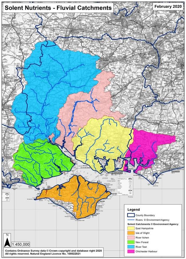
Contents
 1.       Introduction ................................................................................................................... 3
      Purpose of this Technical Advice Note........................................................................................................ 3
      What is Habitats Regulations Assessment? ................................................................................................. 3
      What are the designated sites? ...................................................................................................................... 4
      The South Downs Local Plan.......................................................................................................................... 4
 2.       Undertaking Habitats Regulations Assessment ......................................................... 6
      Overview ............................................................................................................................................................. 6
      Screening – The ‘Likely Significant Effects’ Test ......................................................................................... 8
      Appropriate Assessment – The ‘Adverse Effects on Integrity’ Test ..................................................... 9
 3.       The International Sites ............................................................................................... 11
      How to use this section ................................................................................................................................. 11
      Arun Valley Special Protection Area SAC, SPA and Ramsar ................................................................ 11
      The ‘Sussex Bat Sites’ – Ebernoe Common, The Mens, Singleton & Cocking Tunnels Special
      Areas of Conservation (SAC)....................................................................................................................... 12
      Butser Hill SAC ................................................................................................................................................ 14
      Castle Hill SAC ................................................................................................................................................ 14
      Duncton to Bignor Escarpment SAC.......................................................................................................... 15
      East Hampshire Hangers SAC ...................................................................................................................... 15
      Kingley Vale SAC ............................................................................................................................................. 16
      Lewes Downs SAC ......................................................................................................................................... 16
      River Itchen SAC ............................................................................................................................................. 16
      Rook Clift SAC ................................................................................................................................................ 17
      The ‘Solent Coast’ International Sites ........................................................................................................ 18
      Shortheath Common SAC ............................................................................................................................ 21
      Wealden Heaths Phase II SPA ...................................................................................................................... 21
      Woolmer Forest SAC .................................................................................................................................... 22

                                                                                                                                                                            2
1. INTRODUCTION
Purpose of this Technical Advice Note
1.1 The purpose of this Technical Advice Note (TAN) is to provide further guidance on how to
undertake Habitats Regulations Assessment of development proposals in the South Downs
National Park. It supports the implementation of the Conservation of Habitats and Species
Regulations 2017 (as amended) (‘Habitats Regulations’) and Local Plan policies, in particular
Policy SD9 Biodiversity and Geodiversity and Policy SD10 International Sites.
1.2 This TAN is divided into the following sections:
1 – Introduction: What is HRA?
2 – The HRA Process: Overview, Screening and Appropriate Assessment
3 – The International Sites: An introduction to each and an overview of key planning
considerations
1.3 This TAN is a material consideration that will be taken into account by decision makers at the
Authority when determining planning applications that have the potential to impact on
international nature conservation designations.
1.4 Habitats Regulations Assessment is subject to frequent changes as knowledge and experience
of public bodies and the private sector improves, as well as from the outcome of case law. This
TAN will be updated to reflect changes in evidence and guidance as necessary.
What is Habitats Regulations Assessment?
1.3 There are many sites of international nature conservation importance within, or in proximity
to, the National Park. Their influence and potential for impacts upon them are not constrained
by the National Park boundaries or those of other Local Planning Authorities outside of the
National Park. Our International Sites are the jewels in the crown of our designated sites and
have the highest level of protection. These are protected under the Conservation of Habitats
and Species Regulations 2017 (as amended)1 which transposes European Directives2 and Global
Agreements3 into UK Law. Sites protected under these regulations are hereafter referred to as
‘International Sites’. The UK left the EU on 31 January 2020 under the terms set out in the
European Union (Withdrawal Agreement) Act 2020 (“the Withdrawal Act”) and a transition
period which ended in December 2020. The most recent amendments to the Habitats
Regulations – the Conservation of Habitats and Species (Amendment) (EU Exit) Regulations
20194 – make it clear that the need for HRA will continue after the end of the Transition Period.
Consequently, there is a statutory obligation in law to give due regard to the International Sites
over and above Development Plans and any supplementary planning documents.
1 Conservation of Habitats and Species Regulations 2017 (as amended)
https://www.legislation.gov.uk/uksi/2017/1012/contents/made
2 EC Council Directive 92/43/EEC ‘Habitats Directive’
https://ec.europa.eu/environment/nature/legislation/habitatsdirective/index_en.htm
Directive 2009/147/EC ‘Birds Directive’
https://ec.europa.eu/environment/nature/legislation/birdsdirective/index_en.htm#:~:text=The%20Birds%20Directive%201%
20In%20a%20nutshell.%20Europe,4%20ORNIS%20Committee.%20...%205%20For%20more%20information
3 Ramsar Convention https://www.ramsar.org/about/the-convention-on-wetlands-and-its-mission
4 Conservation of Habitats and Species (Amendment) (EU Exit) Regulations 2019
https://www.legislation.gov.uk/uksi/2019/579/contents/made
31.4 Habitats Regulations Assessment (HRA) is the process by which the ‘competent
authority’ is required to assess the potential impacts of plans and projects (such as
development proposals put forward in planning applications) on International Sites,
under the Conservation of Habitats and Species Regulations 2017 (as amended).
1.5 The ‘competent authority’ is the South Downs National Park Authority (SDNPA) or the host
authorities5 determining planning applications on behalf of the SDNPA.
1.6 The process of HRA involves an initial ‘screening’ stage to determine if proposals will have likely
significant effects on International Sites; if so, screening is followed by an appropriate assessment
which needs to consider these impacts in more detail and what mitigation measures, if any, can
be achieved to address these.
More information on the HRA process is set out in Part 2.
What are the designated sites?
1.7 There are three types of International Sites designations:
Special Area of Conservation (SAC): Areas which have been given special
protection for a variety of wild animals, plants and habitats.
Special Protection Area (SPA): Identified as being of international importance for
the breeding, feeding, wintering or the migration of rare and vulnerable species of birds
found within EU countries.
Ramsar: Ramsar sites are wetlands of international importance, designated under the
Ramsar Convention on Wetlands6.
1.8 Within the South Downs National Park (SDNP) there are 14 SACs, two of which are also
designated as SPAs for their international importance for birds: the Arun Valley SPA and the
Wealden Heaths Phase II SPA. SACs and SPAs are designated with their own conservation
objectives. The Arun Valley is also designated as a Ramsar site as a wetland of global importance
for its wintering waterfowl, breeding waders, rare wetland invertebrates and scarce plants. In
addition to designations within the SDNP, parts of the SDNP are within the zone of influence
of the designated sites of the Solent. The full list of relevant International Sites, including
a description and key matters of consideration, is set out in Section 3 of this
document.
The South Downs Local Plan
1.9 There are two policies in the South Downs Local Plan (SDLP) which include requirements
specifically about internationally designated sites:
Policy SD9 Biodiversity and Geodiversity: This strategic policy sets important
requirements for the conservation and enhancement of biodiversity and geodiversity,
including setting out requirements for the hierarchy of designated sites. Criteria
SD9(2)(a) relates to the protection of all International Sites.
Policy SD10 International Sites: This strategic policy sets out specific requirements
relating to The Mens, Ebernoe Common and Singleton & Cocking Tunnels SAC’s, and
the Arun Valley, Wealden Heaths Phase II, and Solent Coast SPA’s, as recommended by
5 Winchester District Council, East Hampshire District Council, Chichester District Council, Horsham District Council
and Lewes District Council
6 The Ramsar Convention on Wetlands of International is an international treaty for the conservation and sustainable use
of wetlands. It is named after the city of Ramsar in Iran, where the Convention was signed in 1971. It came into force in
1975.
4the HRA7 of the SDLP. There are many other International Sites in or near the National
Park that do not have specific requirements arising from the HRA and these sites are
addressed through the requirements and hierarchy as set out in Policy SD9. Further
information on requirements for specific International Sites are set out in
Section 3.
Policies SD9 and SD10 are set out in full in the SDLP:
https://www.southdowns.gov.uk/localplan
7Habitats Regulations Assessment for the South Downs Local Plan (2018) https://www.southdowns.gov.uk/wp-
content/uploads/2018/11/SDLP-05.6-Revised-HRA-in-light-of-Sweetman-II-People-Over-Wind-judgemen....pdf
52. UNDERTAKING HABITATS REGULATIONS
ASSESSMENT
Overview
2.1 In accordance with the Habitats Regulations, all competent authorities must undertake a formal
assessment of the implications of any new development proposals submitted in planning
applications, that may be capable of affecting International Sites before determining whether to
grant or refuse planning permission.
What are the key stages of the assessment?
2.2 The Assessment comprises several distinct stages which are collectively described as a ‘Habitats
Regulations Assessment’ (HRA). The process for HRA is set out in the flow chart below. The
two key stages relevant for the majority of planning applications are:
Screening: for Likely Significant Effects upon International Sites (alone or in
combination with other plans or projects), prior to considering any mitigation measures.
Appropriate Assessment: If likely significant effects are identified, assessing them in
more detail through an appropriate assessment (AA) is required to ascertain whether
an adverse effect on the integrity of the site can be ruled out. This is the stage where
avoidance and mitigation to address impacts is taken into account.
Yes Step 1 – Likely Significant Effects No
Test: Could the development
proposals have likely significant effects
on the site?
Step 2 – Appropriate Assessment
Assess the implications for Test: Could the development
the conservation proposals adversely affect the integrity
objectives of the of the site?
designated site.
Yes No
Redraft the development
Assessment of Alternative
proposals to incorporate
Solutions: Are there
alternative solutions. Yes
alternative solutions?
No
Step 3 – Imperative Reasons of
Overriding Public Interest test: Are there
imperative reasons of overriding public interest?
E.g. human health or safety considerations,
important environmental benefits?
No Yes
Cannot May proceed for IROPI Can
proceed following consultation between proceed
the relevant bodies.
Compensation measures must
be taken.
62.3 Where adverse effects on integrity of an International Site cannot be ruled out, and no
alternative solutions can be identified, then the project can only then proceed if there are
imperative reasons of over-riding public interest and if the necessary compensatory measures
can be secured.
More information on Screening and Appropriate Assessment is found from page 9.
Roles and responsibilities – Who does what?
2.4 South Downs National Park Authority: The SDNPA, and the host authorities who
determine applications on behalf of the SDNPA, are the ‘competent authority’ who carries out
the HRA determination.
The Applicant – The competent authority will require information to be provided by the
applicant to inform the Authority’s assessment prior to a planning application being determined.
This may include specialist technical information such as ecology reports. This information
should be provided as part of the planning application submission to reduce risk of delays in
determining the application. Case officers may request further information during the
determination process as necessary in order to complete the HRA.
Natural England – Natural England has a statutory role and the competent authority, for the
purposes of HRA, must have regard to comments provided by Natural England.
When should HRA be considered and undertaken?
2.5 It is recommended to consider impacts on International Sites early on as this will make it easier
to address any necessary avoidance and mitigation requirements. It is recommended to seek
advice of the authority through the pre-application process, and/or seeking advice from a
suitably qualified ecologist if you think your proposal may impact a designated site. The formal
HRA will be undertaken by the case officer at the planning application stage utilising the
information provided by the applicant. Some necessary information, such as protected species
surveys, may be required to be undertaken at certain times of year; considering this matter
early minimises risks of any delays.
How do I know whether a development proposal will affect an International Site?
2.6 Any proposal that may be capable of affecting an International Site must be considered, no
matter the distance from the site. The SDLP Policies Map shows the locations of the
International Sites8. The Policies Map can be used to see if a development proposal is within or
near an International Site. The Policy SD10: International Sites layer as shown in the
legend also shows buffer zones for some International Sites as recommended by the HRA for
the SDLP. Applications within these zones will need to address the policy requirements of SD10.
To check whether the proposal is located within the Solent catchment, please go to Section 3.
These pre-defined zones will help with determining whether an application may affect the
relevant International Sties. International Sites without predefined zones may still be affected by
development and it will be necessary to impact pathways to all International Sites. More
information on key considerations for specific International Sites is found in Section
3.
What should an applicant include as part of their planning application?
8
South Downs Local Plan Policies Map
https://sdnpa.maps.arcgis.com/apps/webappviewer/index.html?id=41bc8fd8adc34c2e8abd2c4fed013f68
72.7 What information is necessary will depend on the nature and scale of the proposal and the
potential impacts specific to the International Site. This information should be provided as part
of the planning application submission to reduce risk of delays in determining the application.
Case officers may request further information during the determination process as necessary in
order to complete the HRA. Broad types of information may include:
Any necessary specialist assessments, surveys and management plans. For example,
these could include ecology reports, construction management plans, lighting plans and
nutrient budget calculations.
If there are likely to be significant effects on the International Site, avoidance and
mitigation measures will be necessary; include details of these avoidance and mitigation
measures.
If any in combination assessments have been carried out to support the application, then
details of how these have been conducted and which other projects or plans have been
included in the assessment should be supplied.
Applicants may choose to undertake and submit their own HRA assessment for
consideration by the Authority in their own assessment.
More information on key considerations for specific International Sites is found in
Section 3.
What if the application is directly connected with the management of the International
Site?
2.8 The requirement for HRA applies only to plans and projects which are not directly connected
with or necessary to the management of the International Site. In this context the term
‘management’ refers to conservation management.
Screening – The ‘Likely Significant Effects’ Test
2.9 The first stage of any HRA is screening, which is also known as the Likely Significant Effect (LSE)
test. The essential question is:
Is the Project or Plan, either alone or in combination with other relevant projects and plans, likely to
result in a significant effect upon International Sites?
2.10 The LSE test is an initial review to filter out proposals that can, without any detailed appraisal,
be said to be unlikely to result in significant adverse effects upon International Sites. It decides
whether the full subsequent stage – Appropriate Assessment – is required. Case law has
established that, ‘likely’ really means ‘possible’ and a ‘significant’ effect is one where reasonable
scientific doubt remains as to whether it would affect the ability of an International site to
achieve its conservation objectives.
2.11 The first step is to identify any potential impact pathways. In carrying out a HRA it is
important to determine the various ways in which development proposals can impact on
International Sites. Briefly defined, pathways are routes by which a change in activity associated
with a development can lead to an effect upon an International Site. In some cases, this may be
many kilometres distant; factors such a river flow or the ranges of mobile qualifying species such
as bats will have a bearing. If there is no mechanism or pathway for adverse interaction with an
International Site, then LSE can be ruled out.
More information on impact pathways for specific International Sites is found in
Section 3.
82.12 The next step is to consider significance of the effects9 which may arise via the impact pathway.
A significant effect should be considered likely if it:
cannot be excluded on the basis of objective information, and
it might undermine a site’s conservation objectives
2.13 Consideration should be to the nature of the effect, including factors such as:
Probability – how likely is it the effect will occur?
Frequency – how often is the effect likely to occur?
Duration – how long is the effect likely to last?
Reversibility – will the effect be permanent or temporary?
Alone and in combination with other plans or projects – could the effect be of
consequence when considered beyond its individual contribution, to its cumulative
contribution with other plans or projects to an overall significant effect?
2.14 Mitigation and avoidance measures cannot be considered at the screening stage. A legal case10
determined that measures that are specifically introduced to avoid or reduce the harmful effects
of a plan or project on International sites should not be taken into account when forming a view
on LSE. Mitigation should instead only be considered at the appropriate assessment stage.
2.15 The Habitats Directive applies the precautionary principle to International Sites. Lack of
sufficient information, a risk or a possibility of such an effect means that LSE cannot be ruled
out, and appropriate assessment is required.
Appropriate Assessment – The ‘Adverse Effects on Integrity’ Test
2.16 If a development proposal shows potential adverse impacts upon an International Site, then
appropriate assessment (AA) is required. The term ‘appropriate assessment’ is not a technical
term; it literally means whatever level of further assessment is appropriate to draw a conclusion
regarding adverse effects on the integrity of the International Site. The integrity of an
International site is the coherence of its structure and function; more simply put, the assessment
determines whether the ability of the International Site to achieve its conservation objectives
for its qualifying features will be materially compromised.
2.17 The assessment will depend on the nature, location, duration and scale of the proposals and the
interest features of the relevant site. It will need to be proportionate but also sufficient to
determine whether there would be an adverse effect on integrity (AEOI) of the International
Site arising from the proposals alone, or in combination, while ensuring no reasonable scientific
doubt remains. There is no firmly established methodology, but determining whether there
would be AEOI, would involve:
Stating the habitat types and species for which the International Site is protected11
Further analysis of the LSE identified in the screening stage, in the context of the
conservation objectives12, considering implications for the designated features present
9
Examples of an ‘effect’ could be loss of habitat, recreational pressure, impacts to water quality.
10 The Court of Justice of the European Union (CJEU) judgement in the case of ‘People over Wind and Peter Sweetman v
Coillte Teoranta’ (Sweetman II)
11 Available on the Joint Nature Conservation Committee website or the Natural England International Site citation
12 The published conservation objectives for Special Areas of Conservation and Special Protection Areas are available on the
Natural England website:
http://publications.naturalengland.org.uk/category/6528471664689152
9on that site. The assessment must also consider the implications for habitat types and
species present outside the boundaries of that site and functionally linked to the site
and fundamental to the ability of that site to achieve its conservation objectives.
Considering any avoidance or mitigation measures
Due regard to any comments made by Natural England
That any planning conditions appended to any consent which allow the applicant to
subsequently determine parameters relating to construction are sufficient to protect
the integrity of the site.
S106 Agreements can also secure mitigation measures.
2.18 Mitigation and avoidance measures may alleviate any adverse effects to such an extent that
a conclusion of no AEOI can be drawn. As referenced in paragraph 2.14 above, it is at this AA
stage where such mitigation and avoidance measures can be considered. Such measures need
to be sufficiently secured and likely to work in practice. The nature of the measures will depend
on the specific impacts, but broadly include:
switching to a less damaging method of construction;
undertaking works at a less sensitive time of year e.g. outside a breeding season)
pollution control strategies;
contribution to a strategic mitigation strategy;
not proceeding with some parts of the plan or project;
incorporating additional works into the plan or project to avoid or reduce its impact
More information on potential mitigation considerations for specific International
Sites is found in Section 3.
2.19 If there is any doubt about AEOI, the proposal will fail the AA. Conclusions must be made on
the basis of there being no reasonable scientific doubt as to the absence of AEOI.
2.20 If a proposal can avoid and/or mitigate any AEOI, subject to advice from Natural England, and
subject to other planning considerations, permission may be granted. If AEOI cannot be avoided,
then the proposal can only proceed if there are no alternative viable solutions to achieve the
objectives of the project/plan and there are ‘Imperative Reasons of Overriding Public Interest’
(IROPI). The application of these considerations is for the SDNPA as the competent authority.
If both those assessments can be passed, then compensation must be secured to ensure no
overall harm to the International Site network in the UK.
In combination Assessment
2.21 Remember that throughout the assessment process the HRA must consider effects on
International Sites in combination (i.e. cumulatively) with other plans and projects. If the project
or plan in question can be dismissed on its own account because its contribution is very small,
consider whether an ‘in combination’ effect may arise. At the same time take account of case
law, which urges a proportionate and reasonable approach, which the competent authority will
assess. In particular, paragraph 48 of Advocate-General Sharpston’s Opinion in European Court
of Justice Case C-258/11 stated that: ‘the requirement for an effect to be ‘significant’ exists in order
to lay down a de minimis threshold. Plans and projects that have no appreciable effect on the site can
therefore be excluded. If all plans and projects capable of having any effect whatsoever on the site were
to be caught by Article 6(3), activities on or near the site would risk being impossible by reason of
legislative overkill’.
103. THE INTERNATIONAL SITES
How to use this section
3.1 This section introduces the International Sites and provides some initial guidance on potential
impact pathways, and possible avoidance and mitigation measures to be considered. To see
where the International Sites are located, please go to the Policies Map:
https://www.southdowns.gov.uk/planning-policy/south-downs-local-plan/policies-map/
3.2 It is important to note this provides a starting point in considering these International Sites and
the text here is not exhaustive. Impacts and mitigation will depend on the nature and scale of
the development proposals. Please contact the SDNPA or relevant host authority for
information specific to your application. Natural England also operate their own pre-application
service which you may wish to use.
3.3 The HRA13 for the SDLP contains further information, and there are signposts below to the full
reasons for designation, the conservation objectives and supplementary advice produced by
Natural England for each International Site. It should, however, be noted that since the adoption
of the SDLP a further issue of nutrient neutrality has emerged relating to the Solent Coast
International sites, and this may also need to be considered for any net new residential
development within the Solent catchment which extends into the SDNP. More information on
this is set out section on the Solent Coast International Sites below.
Arun Valley Special Protection Area SAC, SPA and Ramsar
3.4 The Arun Valley site is subject to all three designations. The River Arun runs through the site
with the majority of the designated area consisting of low-lying grazing marsh, largely on alluvial
soils. Other habitats include an area of peat derived from a relict raised bog, marshes, fens and
some broadleaved deciduous woodland. Variation in soils and water supply lead to a wider range
of ecological conditions and hence a rich flora and fauna. Southern parts are fed by calcareous
springs and to the north via the greensand where the water is more acidic.
3.5 The Arun Valley designated site is an internationally important wetland for flora and fauna. It is
designated for:
Ramshorn snail (SAC)
Bewick’s swan (SPA)
The assemblage of overwintering waterfowl including species such as shoveler, teal and
wigeon (SPA and Ramsar)
Further information on the reasons for designation is found in the HRA for the SDLP.
Impact pathways
3.6 The potential impact pathways arising from development are:
Impacts to functionally-linked habitat
Impacts on water quality and quantity
Direct impacts to the designated site
Recreational pressure
13
HRA of the South Downs Local Plan https://www.southdowns.gov.uk/wp-content/uploads/2018/11/SDLP-
05.6-Revised-HRA-in-light-of-Sweetman-II-People-Over-Wind-judgemen....pdf
113.7 A potential impact pathway for development proposals on greenfield sites within 5km of the
Arun Valley SAC is the potential impact on ‘functionally-linked habitat’, also known as
‘supporting habitat’. As recognised in the HRA for the SDLP, Bewick’s swans feed on suitable
farmland for foraging in winter months up to 5km from the designated site. Suitable fields within
5km of the SPA could constitute supporting habitat and Policy SD10(3) sets out requirements
for this issue. The 5km zone is shown on the SDLP Polices Map.
3.8 The following impact pathways and potential mitigation measures may also be necessary to
consider:
Impacts on water quality and quantity e.g. flow maintenance and issues of siltation:
The hydrology of the area is essential to maintaining the habitat upon which the
designation features/species rely on. Although ruled out at the strategic level in the
HRA for the SDLP, specific development proposals may impact water flow and quality
into the site, for example due to proximity to a watercourse which may provide a
pathway to the International Site. Such proposals should provide details of any potential
impacts to water, consider how water (foul and surface) will be managed, and provide
information on Sustainable Drainage Systems (SuDs). Proposals should outline
pollution control measures, for example, via a Construction Environmental
Management Plans. These should demonstrate maintenance of water flow and quality.
Development proposals which may impact the
Direct impacts: This may include lighting or noise relating to the construction and/or
operational phases of development in close proximity to the site. A suitable buffer
between the proposed development and the site, a Construction Environmental
Management Plan and lighting plans care in design for operational phases of the
development may be appropriate to address impacts.
Disturbance to birds utilising the site via recreational pressure: Recreational
pressure was ruled out at the strategic level in the HRA for the SDLP based on the
location and scale of development proposed. However, proposals which are
particularly close or are of a scale beyond that which was assessed in the HRA of the
SDLP may need to consider this issue further.
3.9 The full reasons for designation, the conservation objectives and supplementary
advice are found here:
Arun Valley SAC
http://publications.naturalengland.org.uk/publication/4924283725807616?category=652
8471664689152
Arun Valley SPA
http://publications.naturalengland.org.uk/publication/4567444756627456?category=652
8471664689152
The ‘Sussex Bat Sites’ – Ebernoe Common, The Mens, Singleton & Cocking
Tunnels Special Areas of Conservation (SAC)
3.10 Sussex has a diverse landscape with significant areas of linked woodland, riparian habitat and
grassland areas, which support internationally important populations of bats. The Ebernoe
Common SAC is woodland designated for barbastelle and Bechstein’s bats maternity roosts,
The Mens SAC, also woodland, is designated for its barbastelle bat maternity roosts, and
Singleton & Cocking Tunnels SAC is designated for hibernating populations of barbastelle bat
and Bechstein’s bats within the former railway tunnels. In addition to the SAC areas themselves,
12bats are highly mobile and rely on habitats beyond the boundaries of the SACs to sustain their
population. The Mens SAC and Ebernoe Common SAC are also designated for their habitats of
Beech forests on acid soils.
Impact pathways
3.11 The potential impact pathways arising from development are:
Direct impacts to the designated site
Impacts to functionally-liked habitat including flightlines
Recreational pressure
3.12 Policy SD10 (1) and (2) set out requirements for two zones around these SACs as identified
on the SDLP Policies Map. Key potential impact pathway and mitigation considerations in
these zones are:
6.5km zone - The key conservation area and all impacts to bats must be considered:
o Direct impacts to bat habitats of the SACs where development is in close
proximity: This can include pollution, noise and lighting disturbance, which may
impact roost and foraging habitats, and breeding and foraging behaviours. A suitable
buffer between the proposed development and the site, lighting plans, Construction
Environment Management Plans and care in design for operational phases of the
development should be considered.
o Impact on functionally-linked habitats: This would include impacts outlined
above on roosts, foraging and also commuting flightlines habitat that supports the
population. A suitable buffer between the proposed development and the habitat,
retaining key habitats features, lighting plans, Construction Environment
Management Plans and care in design for operational phases of the development
should be considered.
12km zone – The wider conservation area:
o Significant impacts or severance to flightlines: Bats require good connectivity of
landscape features to allow for foraging and commuting between roosts. Mature
vegetative linear features such as woodlands, hedgerows, riverine and wetland
habitats are particularly important. Development can impact flightlines through
removal/physically severing these features, or cause significant impacts to their
functionality, for example, by lighting disturbance. Retaining relevant landscape
features, a suitable buffer between the proposed development and the landscape
features, lighting plans, Construction Environment Management Plans and care in
design for operational phases of the development should be considered.
3.13 More information impact pathways and mitigation measures regarding bats can be found in the
Sussex Bat SAC Planning and Landscape Scale Enhancement Protocol
https://www.southdowns.gov.uk/wp-content/uploads/2018/04/TLL-15-Draft-Sussex-Bat-SAC-
Protocol.pdf
3.14 It should be noted that these requirements do not replace those for other protected species
including other bat species which may utilise the proposed development site but which are not
connected with these International Sites.
3.15 Recreational pressure is an impact pathway that was ruled out at a strategic level in the HRA
for the SDLP based on the location and scale of development proposed. However, applications
for development which are particularly close or are of a scale beyond that which was assessed
in the HRA of the SDLP may need to consider this issue further.
133.16 The full reasons for designation, the conservation objectives and supplementary
advice are found here:
Ebernoe Common SAC
http://publications.naturalengland.org.uk/publication/6255629165395968?category=652
8471664689152
The Mens SAC
http://publications.naturalengland.org.uk/publication/5642356338458624?category=652
8471664689152
Singleton & Cocking Tunnels SAC
http://publications.naturalengland.org.uk/publication/6518329883754496?category=652
8471664689152
Butser Hill SAC
3.17 Butser Hill is predominantly a chalk grassland site. The site has a varied range of slope gradients
and aspects, which have a strong influence on the vegetation composition. The site exhibits
various transitions between semi-natural dry grassland, chalk heath, mixed scrub and yew
woodland. The site is designated for its semi-natural dry chalk grassland and important orchid
sites, and for yew woodland.
Impact pathways
3.18 Vulnerabilities for this SAC generally relate to matters of management, but also air quality. These
impact pathways were not found to cause adverse effects on integrity at the strategic level in
the SDLP HRA. However, it may be the case that certain development proposals particularly
close to the SAC or nearby and at a scale beyond that which was assessed in the HRA of the
SDLP, or of a nature where these issues are particularly acute may need to consider air quality
or other impacts on a case by case basis.
3.19 The full reasons for designation, the conservation objectives and supplementary
advice are found here:
http://publications.naturalengland.org.uk/publication/5067404384141312?category=652847166
4689152
Castle Hill SAC
3.20 Castle Hill SAC is predominantly chalk grassland. It is designated for its chalk grassland which is
important for orchid species, and is also designated for the flowering species early gentian.
Impact pathways
3.21 Vulnerabilities for this SAC generally relate to matters of management such as grazing rather
than specific issues relating to development. However, it may be the case that certain
development proposals particularly close to the SAC or nearby and at a scale beyond that which
was assessed in the HRA of the SDLP that issues such as recreational pressure and direct
impacts to the SAC may need to be considered on a case by case basis.
3.22 The full reasons for designation, the conservation objectives and supplementary
advice are found here:
14http://publications.naturalengland.org.uk/publication/6088288314064896?category=652847166
4689152
Duncton to Bignor Escarpment SAC
3.23 Duncton to Bignor Escarpment SAC comprises escarpment woodland, scrub and grassland. The
site is designated for its Beech Forests on acid soils.
Impact pathways
3.24 Historically this site has relatively few threats and what is key for this site is woodland
management. It may be the case that certain development proposals depending on the nature,
located particularly close to the SAC or nearby and at a scale beyond that which was assessed
in the HRA of the SDLP may need to consider impact pathways of recreational pressure,
urbanisation and direct impacts that are each closely linked with increased people. Impacts
may include pollution in construction and operational phases, disturbance due to lighting or
recreational pressure, impacts to tree root zones due to construction, buildings or recreation
activity. A suitable buffer between the proposed development and the site, a Construction
Environmental Management Plan and lighting plans care in design for operational phases of the
development may be appropriate to address impacts.
3.25 The full reasons for designation, the conservation objectives and supplementary
advice are found here:
http://publications.naturalengland.org.uk/publication/6492790347268096?category=652847166
4689152
East Hampshire Hangers SAC
3.26 The East Hampshire Hangers SAC comprise of a series of woodlands on the western edge of
the Weald and is designated for its dry grasslands on chalk or limestone, and also including
important orchid sites, Beech forests on neutral to rich soils, Tilio-Acerion forests slopes, screes
and ravines (woods of ash, wych elm and lime), Yew dominated woodland and the flowering
plant species early gentian.
Impact pathways
3.27 Vulnerabilities for this SAC generally relate to matters of agriculture and management. It may
be the case that certain development proposals particularly close to the SAC or nearby and at
a scale beyond that which was assessed in the HRA of the SDLP may need to consider impact
pathways of recreational pressure, nutrient run off, urbanisation and direct impacts
that are each closely linked with increased people and built form. Impacts may include pollution
in construction and operational phases, disturbance due to lighting or recreational pressure,
impacts to tree root zones due to construction, buildings or recreation activity. A suitable buffer
between the proposed development and the site, a Construction Environmental Management
Plan, Sustainable Drainage Systems (SuDs) and lighting plans care in design for operational phases
of the development may be appropriate to address impacts.
3.28 The full reasons for designation, the conservation objectives and supplementary
advice are found here:
http://publications.naturalengland.org.uk/publication/6500658190483456?category=652847166
4689152
15Kingley Vale SAC
3.29 Kingley Vale SAC comprises of chalk grassland, scrub and missed oak, ash and ancient yew
forest. It is designated for its chalk grassland and yew dominated woodland, which is considered
to be one of the best areas of its kind in the UK.
Impact pathways
3.30 Vulnerabilities for this SAC generally relate to matters of management, particularly grazing and
scrub management. It may be the case that certain development proposals particularly close to
the SAC or nearby and at a scale beyond that which was assessed in the HRA of the SDLP may
need to consider impact pathways of recreational pressure, urbanisation and direct
impacts which are each closely linked with increased people. Impacts may include pollution in
construction and operational phases, disturbance due to lighting or recreational pressure,
impacts to tree root zones due to construction, buildings or recreation activity. A suitable buffer
between the proposed development and the site, a Construction Environmental Management
Plan and lighting plans care in design for operational phases of the development may be
appropriate to address impacts.
3.31 The full reasons for designation, the conservation objectives and supplementary
advice are found here:
http://publications.naturalengland.org.uk/publication/5727834794360832?category=652847166
4689152
Lewes Downs SAC
3.32 Lewes Downs SAC predominantly consists of chalk grassland and is considered to be one of
the best examples of this habitat in the UK. It is particularly important for orchid species. It is
designated for its chalk grassland and its assemblage of rare and scarce orchids such as the early
spider-orchid.
Impact pathways
3.33 Vulnerabilities for this SAC generally relate to matters of management, but also appropriate
levels of recreational activity and air quality. These impact pathways were not found to
cause adverse effects on integrity at the strategic level. However, it may be the case that certain
development proposals particularly close to the SAC or nearby and at a scale beyond that which
was assessed in the HRA of the SDLP, or of a nature where these issues are particularly acute
may need to be considered on a case by case basis.
3.34 The full reasons for designation, the conservation objectives and supplementary
advice are found here:
http://publications.naturalengland.org.uk/publication/4618459505754112?category=652847166
4689152
River Itchen SAC
3.35 The River Itchen is considered to be one of the finest examples of a chalk river in Europe. The
SAC site comprises chalk steam and river, fen meadow, flood pasture, wet woodlands, side
channels, runnels and ditches associated with the main river and water meadows. Outside of
16the designated area, the headwaters, tributaries and wider habitat have an important relationship
with the SAC. The River Itchen SAC is designated for both habitats and species: River habitat
with floating vegetation often dominated by watercrowfoot, Southern damselfly, Bullhead fish,
and, although no primary reasons for designation, also White-Clawed crayfish, Otter, Atlantic
salmon, and brook lamprey.
Impact pathways
3.36 The potential impact pathways arising from development are:
Water quality and quantity
Direct impacts on the designated site
Recreational pressure
3.37 An overview of the key impact pathways and potential mitigation measures may be necessary
to consider is set out below:
Impacts on water quality and quantity e.g. flow maintenance and issues of siltation:
The hydrology of the area is essential to maintaining the habitat upon which the
designation features/species rely on. Although ruled out at the strategic level in the
HRA for the SDLP, specific development proposals may impact water flow and quality
into the site, for example, due to proximity to a watercourse which may provide a
pathway to the International Site. Such proposals should provide details of any potential
impacts to water, consider how water (foul and surface) will be managed, and provide
information on Sustainable Drainage Systems (SuDs). Proposals should outline
pollution control measures, for example, via a Construction Environmental
Management Plans (Construction Environmental Management Plan). These should
demonstrate maintenance of water flow and quality. Development proposals which
may impact the
Direct impacts: This may include lighting or noise relating to the construction and/or
operational phases of development in close proximity to the site. A suitable buffer
between the proposed development and the site, a Construction Environmental
Management Plan and lighting plans care in design for operational phases of the
development may be appropriate to address impacts.
Recreational pressure: Recreational pressure was ruled out at the strategic level in
the HRA for the SDLP based on the location and scale of development proposed.
However, some individual development proposals, such as those which are particularly
close, of a scale beyond that considered by the HRA of the SDLP or applications to
give access to the River Itchen may need to consider this issue further.
3.38 The full reasons for designation, the conservation objectives and supplementary
advice are found here:
http://publications.naturalengland.org.uk/publication/5130124110331904?category=652847166
4689152
Rook Clift SAC
3.39 Rook Clift SAC is woodland designated for its Tilio-Acerion forests slopes, screes and ravines
(woods of ash, wych elm and lime) dominated by large-leaved lime which is considered to be
one of the best areas in the UK.
17Impact pathways
3.40 Key vulnerabilities related to a woodland site such as this are to do with grazing and other
management matters. It may be the case that certain development proposals particularly close
to the SAC or nearby and at a scale beyond that which was assessed in the HRA of the SDLP
may in need consider impact pathways of recreational pressure, urbanisation and direct
impacts, which are each closely linked with increased people. Impacts may include pollution in
construction and operational phases, disturbance due to lighting or recreational pressure,
impacts to tree root zones due to construction, buildings or recreation activity. A suitable buffer
between the proposed development and the site, a Construction Environmental Management
Plan, lighting plans and care in design for operational phases of the development may be
appropriate to address impacts.
3.41 The full reasons for designation, the conservation objectives and supplementary
advice are found here:
http://publications.naturalengland.org.uk/publication/6335772969926656?category=652847166
4689152
The ‘Solent Coast’ International Sites
3.42 The Solent Coast sites included several overlapping designations14. The sites are designated for
their overall waterbird assemblage and specific birds species including brent goose, shoveler,
curlew and tern species (SPA designation), a range of habitats including estuaries, coastal
lagoons, and intertidal mudflats and sandbanks and for the species Desmoulin’s whorl snail (SAC
designation).
Impact pathways
3.43 There are two key impact pathways development proposals that will need to be
considered: recreational disturbance and water quality regarding increased
nutrients.
3.44 The bird species, particularly the over wintering species, which are designated features of the
Solent SPAs are vulnerable to recreational pressure, primarily as a result of disturbance from
people and dogs passing on the coast. This issue was explored by authorities across the South
Hampshire sub-region and it was determined that the impact of increased development and
subsequent recreational activity on the Solent is likely to be significant in combination across
the sub-region. The key area identified was the area within 5.6km of the Solent designations.
Small areas of the National Park fall within this zone as shown on the SDLP Policies Map. As
set out in Policy SD10(7), proposals for a net increase in residential units within this zone will
require mitigation. The South Downs National Park Authority formally adopted the Bird Aware
Solent strategy15 in April 2018. The Bird Aware Solent strategy is adopted by authorities across
the affected area and provides a strategic solution to ensure the requirements of the Habitats
Regulations are met. To address their mitigation requirements, applicants can make a financial
contribution to Bird Aware Solent which undertakes various mitigation activates. More
information about Bird Aware Solent can be found here: https://solent.birdaware.org/home and
on the SDNPA website here: https://www.southdowns.gov.uk/community-infrastructure-
levy/rates/solent-recreation-mitigation-strategy-developer-contributions/
14
Solent Maritime SAC, Solent and Southampton Water SPA, Portsmouth Harbour SPA, Chichester &
Langstone Harbours SPA, Solent and Dorset SPA
15
Also known as the Solent Recreation Mitigation Strategy (SRMS)
183.45 International Sites of the Solent area are known to be vulnerable to elevated nutrient
(nitrogen) levels. Elevated nitrogen levels can affect vegetation growth and cause
eutrophication, which affects food resources for qualifying species such that it affects the status
and distribution of those species and therefore act against the stated conservation objectives of
the designated sites. It is recognised that a large contribution of nutrient inputs are from
agricultural sources such as fertiliser run off. Notwithstanding a small but notable contribution
comes from human wastewater outputs.
3.46 Natural England advises that there is a likely significant effect due to the increase in wastewater
from new housing and tourism overnight accommodation in the Solent catchment area. For
applications within the catchment area (see the map in figure 3 below) Natural England provides
mitigation guidance16. The ‘nutrient neutral’ approach to address this issue is endorsed, which
in summary involves undertaking calculations following the guidance set out by NE to determine
if an overall increase in nitrates will result, and if so by how much. If an increase in nitrates
output is identified, then mitigation measures will be required.
3.47 Mitigation measures are likely to involve a combination of water efficiency measures, on site
water quality measures, and land offsetting. Offsetting involves taking land out of agricultural
use, i.e. no longer adding additional nitrates to the land at that location, to balance or ‘offset’
the increase in nitrates arising from housing or tourism accommodation development.
3.48 The Solent catchment comprises a series of fluvial catchments – watercourses and their
catchments which run into the Solent. Natural England advises that offsetting land should be in
the fluvial catchment where the development is taking place, or possible another nearby fluvial
catchment subject to agreement from Natural England. Developments which discharge to
Waste Water Treatment Works or use other methods of managing waste water such as
Package Treatment Plants will need to address this issue.
3.49 The full reasons for designation, the conservation objectives and supplementary
advice are found here:
Solent Maritime SAC
http://publications.naturalengland.org.uk/publication/5762436174970880?category=652
8471664689152
Solent and Southampton Water SPA
http://publications.naturalengland.org.uk/publication/6567218288525312?category=652
8471664689152
Portsmouth Harbour SPA
http://publications.naturalengland.org.uk/publication/4857883850178560?category=652
8471664689152
Chichester and Langstone Harbours SPA
http://publications.naturalengland.org.uk/publication/5789102905491456?category=652
8471664689152
Solent and Dorset SPA
http://publications.naturalengland.org.uk/publication/5294923917033472?category=652
8471664689152
16
Natural England guidance on achieving nutrient neutral development, June 2020
https://www.push.gov.uk/2020/06/11/natural-england-published-nutrient-calculator-and-updated-guidance-on-
achieving-nutrient-neutral-housing-development/
19FIGURE 1: THE SOLENT CATCHMENT AND FLUVIAL CATCHMENTS
WITHIN THE WIDER SOLENT CATCHMENT
(PUBLISHED BY NATURAL ENGLAND JUNE 2020)
20Shortheath Common SAC
3.50 Shortheath Common SAC comprises large areas of open heathland and the intermediate stages
of success to oak woodland, and valley mire. The site supports significant populations of rare
and local invertebrate fauna including dragonflies and butterflies. The SAC is designated for its
habitats of transition mires and quaking bogs, European dry heaths and bog woodland.
Impact pathways
3.51 Vulnerabilities for this SAC generally relate to matters of management, particularly grazing and
scrub and tree management. It may be the case that certain development proposals particularly
close to the SAC or nearby and at a scale beyond that which was assessed in the HRA of the
SDLP may need to consider impact pathways of urbanisation and direct impacts which are
each closely linked with increased people. Impacts may include pollution in construction and
operational phases, damage due to recreational pressure, fire and fly tipping, and impacts on
hydrology. A suitable buffer between the proposed development and the site, a Construction
Environmental Management Plan and care in design for operational phases of the development
may be appropriate to address impacts.
3.52 The full reasons for designation, the conservation objectives and supplementary
advice are found here:
http://publications.naturalengland.org.uk/publication/4851353352404992?category=652847166
4689152
Wealden Heaths Phase II SPA
3.53 The Wealden Heaths Phase II (WHP2) SPA comprises four separate SSSI units – Woolmer
Forest SSSI and SAC, Broxhead and Kingsley Commons SSSI, Bramshott and Ludshott
Commons SSSI, and Devil’s Punch Bowl SSSI. Across WHP2 SPA there are a range of important
habitats including heathland, acid grassland, scrub and small meadows, and broadleaved and
coniferous woodland. WHP2 SPA is designated for its breeding bird species of nightjar,
woodlark and Dartford warbler.
Impact pathways
3.54 The WHP2 SPA is vulnerable to recreational pressure, urbanisation and direct
impacts. The HRA for the SDLP assessed these impact pathways and recommended two zones
around the WHP2 SPA and particular requirements for development proposals within these
zones: 400m of the SPA, and a 400m to 5km zone from the SPA.
3.55 Within 400m of the SPA, direct impacts, impacts from urbanisation such as fly-tipping, arson,
cat predation, lighting disturbance, and recreational pressure from walkers, particular dog
walking, are at their highest. The HRA for East Hampshire Joint Core Strategy and the HRA for
the SDLP identified that a certain amount of new housing development could come forward
within the 400m zone safely without adverse effect on the integrity of the SPA.
3.56 Due to the limited amount of development which could come forward and the high need for
affordable housing and gypsy and traveler accommodation in the 400m zone, in 2018 East
Hampshire District Council and SDNPA jointly adopted an SPD which sets the approach the
authorities will take to help meet the need for gypsy, traveller and travelling showpeople
accommodation and rural affordable housing exception sites as this need cannot be met solely
outside of the 400 metre buffer zone. Very little of the remaining allowance is left and it is
21You can also read