Westmeath County Council - Athlone Town Centre: Public Realm Enhancement Scheme 07469850063
←
→
Page content transcription
If your browser does not render page correctly, please read the page content below
Westmeath County Council
                  Athlone Town Centre: Public Realm
                  Enhancement Scheme
                  EIA Screening Report
                  Ref. 038-01
                  Final | March 2021

                                                     07469850063

                                    info@carlinplanning.com

                                www.carlinplanning.com

The Courtyard, 380C Belmont Road, Belfast, BT4 2NF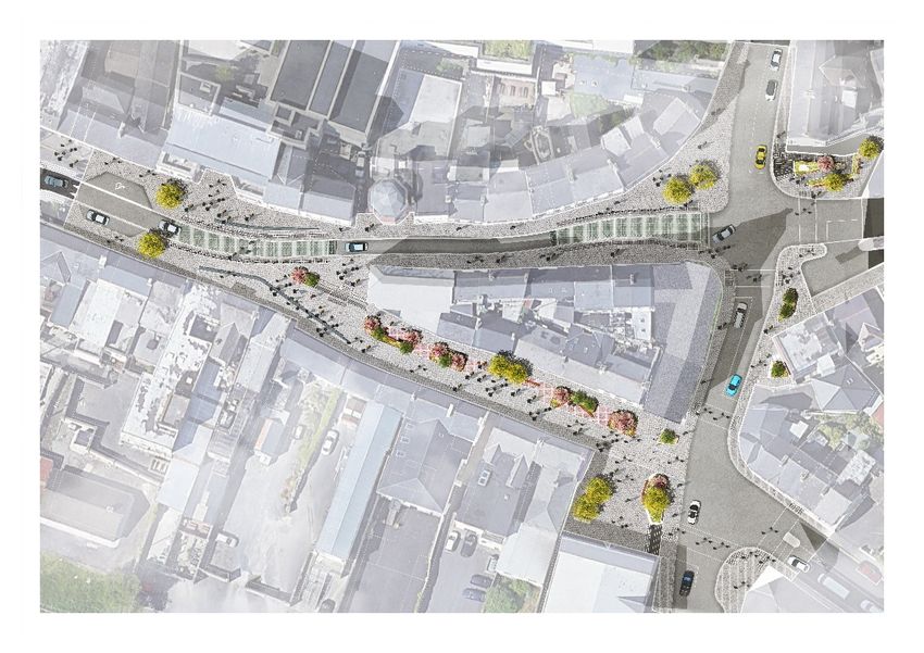
Westmeath County Council                                                              Athlone Town Centre: Public Realm Enhancement Scheme
                                                                                                                         EIA Screening Report

Contents

                                                                                                                             Page No.
1                Introduction                                                                                                            1

2                Environmental Impact Assessment                                                                                         1
                 2.1                 Legislation                                             1
                 2.2                 Screening for EIA                                       1
                 2.3                 Schedule 7A of the Planning and Development Regulations
                                     2001 (as amended)                                       2

3                EIA Screening Assessment                                                                                                3
                 3.1                 Description of the Development                                3
                 3.2                 Location and environmental sensitivity                        6
                 3.3                 Aspects of the enviroment likely to be significntly affected 15

4                Conclusion                                                                                                            17

Ref. 038-01 | Final | March 2021
HTTPS://CARLINPLANNINGLIMITED-MY.SHAREPOINT.COM/PERSONAL/KIERAN_CARLINPLANNING_COM/DOCUMENTS/PROJECTS/038 - ATHLONE EIA
SCREENING/03_REPORTS/FINAL REPORTS_MARCH 2021/EIA SCREENING_FINAL_ISSUED 12.03.2021.DOCX
1                      Introduction
This Environmental Impact Assessment (EIA) Screening Report has been prepared by
Carlin Planning Limited on behalf of Westmeath County Council (WCC), for the proposed
Public Realm Enhancement Works (“proposed development”) in Athlone Town Centre.
The Screening Assessment has been undertaken in accordance with the Planning &
Development Regulations 2001 (as amended) which transposes the requirements of
European Directives 2011/92/EU and 2014/52/EU (EIA Directive).
The purpose of the Screening Assessment is to determine whether or not an EIA is
required for the proposed development. Screening is part of the EIA Directives overall
aim to determine if a project is likely to have significant effects on the environment.
Screening will also ensure that EIA is only carried out for those projects for which it is
thought that a significant impact on the environment is possible, therefore ensuring a
more efficient use of both public and private resources.
The Screening Report follows the structure set out in Schedule 7A of the Planning and
Development Regulations 2001 (as amended).
An Appropriate Assessment (AA) Screening (Stage 1: ‘Test of Likely Significance’) has also
been undertaken (available as a separate report – Ref. 234/2020-02). The AA screening
assessment determines that the proposal will not have any significant effects, either alone
or in combination, on any Natura 2000 sites. It concludes that no further assessment is
required.

2                      Environmental Impact Assessment

2.1                    Legislation
The EIA Directive has been transposed into domestic legislation by the Planning and
Development Regulations 2001 (as amended).

Annex 1 and 2 of the EIA Directive have been transposed into Schedule 5 (Part 1 and 2) of
the Planning and Development Regulations 2001 (as amended).

2.2                    Screening for EIA
Schedule 5 (Part 1) of the Planning and Development Regulations 2001 (as amended) lists
types of development and relevant thresholds that inform when a mandatory
Environmental Impact Assessment Report (EIAR) 1 is required. Generally, these
developments consist of intensive industrial, waste management and transport projects.
The proposed development does not fall within any of the types of development listed
therefore does not require a mandatory EIAR.

1
    Section 172 of the Planning and Development Regulations (as amended)
Ref. 038-01 | Final | March 2021
HTTPS://CARLINPLANNINGLIMITED-MY.SHAREPOINT.COM/PERSONAL/KIERAN_CARLINPLANNING_COM/DOCUMENTS/PROJECTS/038 - ATHLONE EIA
SCREENING/03_REPORTS/FINAL REPORTS_MARCH 2021/EIA SCREENING_FINAL_ISSUED 12.03.2021.DOCX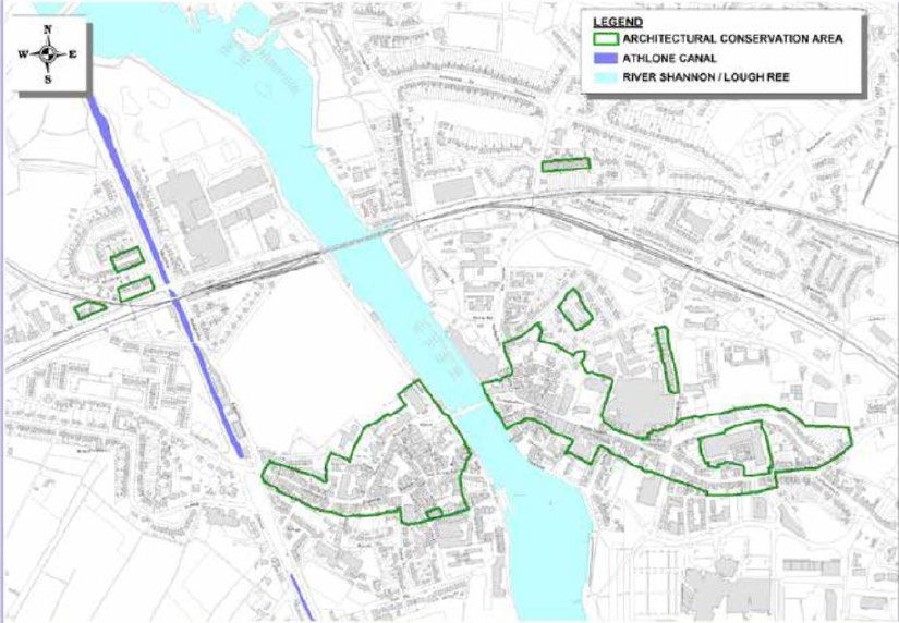
Schedule 5 (Part 2) lists various types of development and associated thresholds. Where
a proposed development falls within the type of development and meets or exceeds the
relevant threshold, a screening assessment is required, taking into account the
information set out within Schedule 7 of the Planning and Development Regulations 2001
(as amended). The term “sub-threshold development” means development of a type set
out in Part 2 of Schedule 5 which does not equal or exceed, as the case may be, a quantity,
area or other limit specified in that Schedule in respect of the relevant class of
development 2 . Sub-threshold development should be screened with regard to the
requirements set out in Schedule 7A of the Regulations.
The most relevant class of development within Part 2 (Schedule 5) is “urban development
which would involve an area greater than 2 hectares (ha) in the case of a business district,
10 hectares in the case of other parts of a built-up area and 20ha elsewhere” (Schedule 5,
Part 2, 10 (iv)).
In this paragraph, “business district” means a district within a city or town in which the
predominant land use is retail or commercial use. The location of the proposed
development is within a business district therefore the relevant threshold is 2 ha. The
development site at 0.56 ha is well below the 2ha threshold.

2.3                    Schedule 7A of the Planning and Development
                       Regulations 2001 (as amended)
Schedule 7A requires:
1. a description of the proposed development, including in particular:
              (a) a description of the physical characteristics of the whole proposed
              development and, where relevant, of demolition works, and
              (b) a description of the location of the proposed development, with particular
              regard to the environmental sensitivity of geographical areas likely to be affected.
2. A description of the aspects of the environment likely to be significantly affected by the
proposed development.
3. A description of any likely significant effects, to the extent of the information available
on such effects, of the proposed development on the environment resulting from:
              (a) the expected residues and emissions and the production of waste, where
              relevant, and
              (b) the use of natural resources, in particular soil, land, water and biodiversity.
4. The compilation of the information at paragraphs 1 to 3 shall take into account, where
relevant, the criteria set out in Schedule 7.

2
    Part 10 of the Planning and Development Regulations (as amended)
Ref. 038-01 | Final | March 2021
HTTPS://CARLINPLANNINGLIMITED-MY.SHAREPOINT.COM/PERSONAL/KIERAN_CARLINPLANNING_COM/DOCUMENTS/PROJECTS/038 - ATHLONE EIA
SCREENING/03_REPORTS/FINAL REPORTS_MARCH 2021/EIA SCREENING_FINAL_ISSUED 12.03.2021.DOCX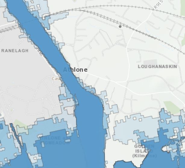
3                      EIA Screening Assessment

3.1                    Description of the Development

                 3.1.1                   Overview
The proposed development consists of enhancements to the public realm (i.e. public
streets and spaces).
The flagship Church Street Enhancement project was completed in April 2019. WCC now
wish to unify the disparate commercial areas along Dublin Gate Street, diverging along
Mardyke Street and Sean Costello Street and along Pump Lane completing the triangular
enclosure (see Figure 1). WCC seek to remedy the disconnect between the west and east
bank by providing a strong aesthetic definition to the streets of the town core, using
natural stone pavements, creating a pedestrian friendly core that invites exploration by
everyone.
WCC has secured Category B funding from the National Urban Regeneration Development
Fund (URDF) to deliver this scheme. A separate scheme for Market Square on the west
bank of the River Shannon has also secured funding.

                                                             Figure 1: Site Location

                 3.1.2                   Key Design Principles
The scheme has been developed around a number of key design principles as follows:
Wayfinding: The implementation of intuitive wayfinding that could work with a wider
Town Centre strategy using routes, junctions and landmarks to help orientate people.

Ref. 038-01 | Final | March 2021
HTTPS://CARLINPLANNINGLIMITED-MY.SHAREPOINT.COM/PERSONAL/KIERAN_CARLINPLANNING_COM/DOCUMENTS/PROJECTS/038 - ATHLONE EIA
SCREENING/03_REPORTS/FINAL REPORTS_MARCH 2021/EIA SCREENING_FINAL_ISSUED 12.03.2021.DOCX
Layout: Street layout and selection of materials is to consider and follow the principles of
the ‘Design Manual for Urban Roads and Streets’ avoiding clutter, complicated layouts
and over design. The objective is a ‘de-cluttered’ streetscape that reduces street furniture
and signage and promotes a simplified and legible environment.
Sustainability: Proposals that show a move towards a low carbon, climate resilient
sustainable environment, considering and complying with the Westmeath County Council
Climate Adaption Strategy 2019 – 2024.
Pedestrians / Accessible: The creation of a legible environment that is accessible and
appealing for all and applies the guidance of documents such as ‘Building for Everyone: A
Universal Design Approach’. The design approach must place the pedestrian at the highest
level of consideration with essential vehicle movements being layered in around the
requirements of people. This approach is consistent with the ‘de-cluttering’ of streets,
providing legible pedestrian environments further enhanced through improved crossings,
junctions and public lighting.
Details and Materials: Specific objectives in the use and implementation of materials and
detailing have been defined for the project, including the height and materiality of kerbs;
the requirement for high quality, aesthetically appropriate and robust surfacing; and
consideration of durability, life-cycle cost and sustainable maintenance of proposed
materials.
Soft Landscape: The consideration of soft landscape including tree planting. Placement of
these should consider climate, durability, sightlines and space within the streets.
Any tree planting is to be semi-mature, and placement of individual trees is to be
considered as they form points of interest within the streetscape.
Lighting: Lighting is to be used to provide visual interest but must not detract from the
fabric of Athlone’s Town Centre. LED luminaires are to be used and reduction of clutter is
to be supported through the use of building mounted luminaires wherever feasible.
Feature lighting is to be carefully considered, including the lighting of key buildings,
artwork or monuments.
Street Furniture: The approach to street furniture is to integrate wherever possible, and
to coordinate with the rest of the proposals. Issues such as durability and maintenance
are to be fully considered, and locations within the public realm must not impede
pedestrian flow.

                 3.1.3                   Physical description of the works
The Development of Public Realm Enhancement Works, encompassing approximately
0.6HA at Mardyke St, Pump Lane and Sean Costello St, Athlone, Co. Westmeath, including
the following public realm improvements:
         • Provision of upgraded footpaths and realignment of existing carriage way
            along Mardyke Street, including 120m of a shared surface and pedestrianisa-
            tion of 90m of Sean Costello Street, from its junction with Pump Lane to its
            junction with Mardyke Street, to take account of the access needs of pedes-
            trians, mobility impaired persons and service vehicles.
         • Provision of an enhanced public realm and landscape improvements,
            including street furniture, incidental play equipment, cycle parking, trees, and
            soft landscaping to enhance biodiversity.

Ref. 038-01 | Final | March 2021
HTTPS://CARLINPLANNINGLIMITED-MY.SHAREPOINT.COM/PERSONAL/KIERAN_CARLINPLANNING_COM/DOCUMENTS/PROJECTS/038 - ATHLONE EIA
SCREENING/03_REPORTS/FINAL REPORTS_MARCH 2021/EIA SCREENING_FINAL_ISSUED 12.03.2021.DOCX
•
Provision of a priority signalised junction, including enhanced pedestrian
facilities, at the junction of Mardyke Street, Gleeson Street, Pump Lane, and
St Mary’s Square.
• Upgrade to public lighting, including focal lighting to Sean Costello Street.
And all necessary accommodation works, including utility provision, drainage, signage,
and other ancillary works.
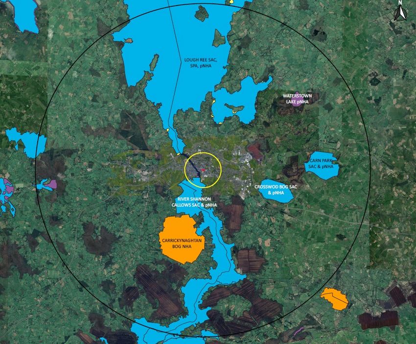
Figure 2: Proposed Layout
3.1.4 Demolition Works / Waste Produced
No significant demolition is required for the proposed development. Existing paving
materials and furniture will be replaced, and any waste generated will be inert
construction and demolition waste that will be utilised on site wherever possible. Waste
that cannot be reused (for example, street furniture) will be transferred to an appropriate
waste management facility. No significant environmental impacts will result.
3.1.5 Changes to traffic movements and circulation
Several design options have focused on the movement of traffic on Mardyke Street and
Sean Costello Street. The preferred option is the pedestrianisation of Sean Costello Street
which unlocks a large area and opportunity to address Dunnes Store entrance and the
southern end of the derelict site to create a ‘Gateway’.
A traffic ‘Forecasting Report’ (Ref: 300706) was prepared by Systra Ltd which sought to
assess the traffic impacts of the proposed public realm enhancements. The Forecasting
Report concluded that “the proposed Option 3 scheme has no significant impact on traffic
conditions and operates at a very similar level to the Do Minimum Scenario. This option is
the recommended option for this public realm scheme from a traffic modelling perspective.
The minor journey time impacts are not likely to instigate any re-routing from the area so
Ref. 038-01 | Final | March 2021
HTTPS://CARLINPLANNINGLIMITED-MY.SHAREPOINT.COM/PERSONAL/KIERAN_CARLINPLANNING_COM/DOCUMENTS/PROJECTS/038 - ATHLONE EIA
SCREENING/03_REPORTS/FINAL REPORTS_MARCH 2021/EIA SCREENING_FINAL_ISSUED 12.03.2021.DOCX
it is considered that this would not impact upon the wider Athlone network in any way”
(p17).

                 3.1.6                   Cumulation with other existing development and/or
                                         approved development
The proposed development will complement the flagship Church Street Enhancement
project completed in April 2019. A search of planning applications in the area has not
identified any relevant approved or pending projects.

                 3.1.7                   The use of natural resources, in particular land, soil, water
                                         and biodiversity
Natural resources required for the project mainly consist of the paving materials. This is
in modest quantities given that the site is 0.56 ha.

                 3.1.8                   Pollution and nuisances
There will be no residues or emissions generated from the proposed development during
operation due to the fact that it is a public realm enhancement scheme.
The pedestrianisation of Sean Costello Street will mean that more traffic will be diverted
to Mardyke Street (particularly the stretch of the street between 18-38 Mardyke Street).
This is a relatively short stretch of the street (c. 100m) and is predominantly commercial
properties.
There may be emissions from vehicles during the construction phase, however this is
normal for any construction project and will be managed through the Construction
Environmental Management Plan.

                 3.1.9                   The risk of major accidents and/or disasters
There is no risk of major accidents or disasters due to the proposed development.

                 3.1.10                  The risks to human health (for example, due to water
                                         contamination or air pollution)
The proposed development will not present any risks to human health.

3.2                    Location and environmental sensitivity
The site extends east along Dublin Gate Street, diverging along Mardyke Street and Sean
Costello Street and along Pump Lane completing the triangular enclosure. Mardyke Street
and Sean Costello Street are the primary approaches to the town from the east.
The extent of the site is characterised by narrow footpaths, with varying levels and a
multitude of paving materials. The environment is not currently welcoming or
aesthetically pleasing. All streets are dominated by vehicles, with a prevalence of car
parking along Mardyke Street and a predominance of bollards along Sean Costello Street
to channel vehicular traffic.

Ref. 038-01 | Final | March 2021
HTTPS://CARLINPLANNINGLIMITED-MY.SHAREPOINT.COM/PERSONAL/KIERAN_CARLINPLANNING_COM/DOCUMENTS/PROJECTS/038 - ATHLONE EIA
SCREENING/03_REPORTS/FINAL REPORTS_MARCH 2021/EIA SCREENING_FINAL_ISSUED 12.03.2021.DOCX
3.2.1                   Flood Risk
The site is not within or adjacent to an area at risk of flooding (see Figure 3).

                                         Figure 3: Flood Maps (source, Floodinfo.ie.)

                 3.2.2                   Historic Environment

Protected structures
There are no protected structures recorded in the Records of Protected Structures or
National Inventory of Architectural Heritage (NIAH) within the redline boundary for the
development. There are however seven recorded protected structures fronting onto the
development area (Figure 4). Table 1 provides a summary of these structures.

  Table 1: Protected structures fronting onto the development area.

  NIAH/RPS No.                     Location                                                                     Summary
  15009142/ 162                    Dublin Gate Street                                                           Moran’s Bar
  15009143/ 163                    Dublin Gate Street                                                           Moran’s Bar
  15009364/ 213                    30 Mardyke Street                                                            House
  15009365/ 214                    32 Mardyke Street                                                            House
  15009366/ 215                    34 Mardyke Street                                                            Carey’s Public House
  15009392/220                     Mardyke Street                                                               Wall mounted post box

Ref. 038-01 | Final | March 2021
HTTPS://CARLINPLANNINGLIMITED-MY.SHAREPOINT.COM/PERSONAL/KIERAN_CARLINPLANNING_COM/DOCUMENTS/PROJECTS/038 - ATHLONE EIA
SCREENING/03_REPORTS/FINAL REPORTS_MARCH 2021/EIA SCREENING_FINAL_ISSUED 12.03.2021.DOCX
15009390 Mardyke Street O’Neill’s Bar 3
Figure 4: Protected structures in the area
Architectural Conservation Area
The entirety of the site is located within the designated Architectural Conservation Area
as outlined in the Athlone Town Development Plan 2014-2020.
An Architectural and Heritage Impact Assessment has assessed the potential impacts of
the proposed development on both the setting of Protected Structures and also the
Architectural Conservation Area. The findings have been discussed below at Section 3.4.4
3
Destroyed by fire – December 2010
Ref. 038-01 | Final | March 2021
HTTPS://CARLINPLANNINGLIMITED-MY.SHAREPOINT.COM/PERSONAL/KIERAN_CARLINPLANNING_COM/DOCUMENTS/PROJECTS/038 - ATHLONE EIA
SCREENING/03_REPORTS/FINAL REPORTS_MARCH 2021/EIA SCREENING_FINAL_ISSUED 12.03.2021.DOCXFigure 5: Athlone Architectural Conservation Area (source: Athlone Town
Development Plan 2014-2020)
Archaeological and Cultural Heritage
The proposed development is located within the Zone of Archaeological Potential for
Athlone as identified within the Urban Archaeological Survey for Westmeath. This area
corresponds with the Zone of Notification as shown on the National Monuments Service
map-viewer. A detailed Archaeological and Cultural Heritage Assessment has been
prepared as a separate report. The findings of this report have been referenced below at
Section 3.4.4
3.2.3 Natural Environment
Designated Sites
The Ecological Impact Assessment (EcIA) undertaken identifies designated sites within a
radius of 15 kilometres of the proposed development. Sites beyond 15km were also
considered but no potential for significant effects was identified on such sites. The
designated sites considered are listed in Table 2. The location of EU and Nationally
Designated Sites in relation to the site are displayed in Figure 6. The proposed
development lies 393m north east of River Shannon Callows pNHA, and 440m north east
of Middle Shannon Callows SPA and River Shannon Callows SAC. Further designated sites
in the vicinity include Lough Ree SAC and pNHA 1.5km to the north west, and Lough Ree
SPA situated 1.6km to the north west.
Ref. 038-01 | Final | March 2021
HTTPS://CARLINPLANNINGLIMITED-MY.SHAREPOINT.COM/PERSONAL/KIERAN_CARLINPLANNING_COM/DOCUMENTS/PROJECTS/038 - ATHLONE EIA
SCREENING/03_REPORTS/FINAL REPORTS_MARCH 2021/EIA SCREENING_FINAL_ISSUED 12.03.2021.DOCXTable 2
Distance from
Designated Site proposed Reason for designation
development
Special Area of Conservation (SAC)
[6410] Molinia Meadows
[6510] Lowland Hay Meadows
River Shannon Callows 0.44km [8240] Limestone Pavement
[91E0] Alluvial Forests
[1355] Otter (Lutra lutra)
[3150] Natural Eutrophic Lakes
[6210] Orchid‐rich Calcareous Grassland
[7110] Active Raised Bog
[7120] Degraded Raised Bog
Lough Ree 1.52km [7230] Alkaline Fens
[8240] Limestone Pavement
[91D0] Bog Woodland
[91E0] Alluvial Forests
[1355] Otter (Lutra lutra)
[7110] Raised Bog (Active)
Crosswood Bog 3.4km
[7120] Degraded Raised Bog
[7110] Raised Bog (Active)
Carn Park Bog 6.0km
[7120] Degraded Raised Bog
[3180] Turloughs
Castlesampson Esker 9.0km
[6210] Orchid-rich Calcareous Grassland
[3180] Turloughs
[7110] Raised Bog (Active)
Ballynamona Bog and Corkip
9.5km [7120] Degraded Raised Bog
Lough
[7150] Rhynchosporion Vegetation
[91D0] Bog Woodland
Pilgrim’s Road Esker 9.6km [6210] Orchid-rich Calcareous Grassland
[7110] Raised Bog (Active)
Mongan Bog 9.9km [7120] Degraded Raised Bog
[7150] Rhynchosporion Vegetation
[1013] Geyer's Whorl Snail Vertigo geyeri [7230]
Fin Lough 11.5km
Alkaline fens
[3180] Turloughs
[3270] Rivers with muddy banks with
Lough Funshinagh 12.9km
Chenopodion rubri p.p. and Bidention p.p.
vegetation
Special Protection Area (SPA)
[A038] Whooper Swan (Cygnus cygnus)
[A050] Wigeon (Anas penelope)
[A122] Corncrake (Crex crex)
[A140] Golden Plover (Pluvialis apricaria)
Middle Shannon Callows 0.28km [A142] Lapwing (Vanellus vanellus)
[A156] Black-tailed Godwit (Limosa limosa)
[A179] Black-headed Gull (Chroicocephalus
ridibundus)
[A999] Wetland and Waterbirds
Ref. 038-01 | Final | March 2021
HTTPS://CARLINPLANNINGLIMITED-MY.SHAREPOINT.COM/PERSONAL/KIERAN_CARLINPLANNING_COM/DOCUMENTS/PROJECTS/038 - ATHLONE EIA
SCREENING/03_REPORTS/FINAL REPORTS_MARCH 2021/EIA SCREENING_FINAL_ISSUED 12.03.2021.DOCX[A004] Little Grebe (Tachybaptus ruficollis)
[A038] Whooper Swan (Cygnus cygnus)
[A050] Wigeon (Anas penelope)
[A052] Teal (Anas crecca)
[A053] Mallard (Anas platyrhynchos)
[A056] Shoveler (Anas clypeata)
[A061] Tufted Duck (Aythya fuligula)
Lough Ree 0.72km
[A065] Common Scoter (Melanitta nigra)
[A067] Goldeneye (Bucephala clangula)
[A125] Coot (Fulica atra)
[A140] Golden plover (Pluvialis apricaria)
[A142] Lapwing (Vanellus vanellus)
[A193] Common Tern (Sterna hirundo)
[A999] Wetland and Waterbirds
Natural Heritage Area (NHA)
Carrickynaghtan Bog 2.8km [4] Peatlands
Clonnydonnin Bog 10.2km [7110] Raised Bog
Proposed Natural Heritage Area (pNHA)
River Shannon Callows 0.28km
Lough Ree 0.72km
Crosswood Bog 4.2km
Carn Park Bog 6.4km
Waterstown Lake 6.6km
Castlesampson Esker 7.0km
Mongan Bog 10.3km
Doon Esker Wood 11.1km
Clonfinlough Esker 11.4km
Fin Lough 11.5km
Lough Nanang Esker 12.6km
Lough Funshinagh 12.9km
Feacle Turlough 12.9km
Ballynagarbry 13.1km
Clonlyon Glebe Bog 13.3km
Cranberry Lough 14.9km
Ref. 038-01 | Final | March 2021
HTTPS://CARLINPLANNINGLIMITED-MY.SHAREPOINT.COM/PERSONAL/KIERAN_CARLINPLANNING_COM/DOCUMENTS/PROJECTS/038 - ATHLONE EIA
SCREENING/03_REPORTS/FINAL REPORTS_MARCH 2021/EIA SCREENING_FINAL_ISSUED 12.03.2021.DOCXFigure 6: Designated Sites Habitats As part of the EcIA, a desk survey of the proposed development site was conducted to identify the habitat types present, due to the entirely urban character of the site. Habitats were identified in accordance with the Heritage Council's 'Guide to Habitats in Ireland'. A Site Visit could not be undertaken due to the previous and current Covid-19 restrictions both north and south of Ireland. Restrictions in the north of Ireland restrict travel to within 10m from your home and in the south of Ireland travel is restricted to within 5km of your home. However, effective desk-based surveys have been carried out as an alternative. The surveyed development site comprises of several streets, predominantly Mardyke Street and Sean Costello Street, and small parts of Dublin Gate Street, Gleeson Street, St Mary’s Square, Pump Lane, John Broderick Street, and Griffith Street. Paved areas and a small area of off-street parking are also present. These were readily identifiable using Google Maps aerial imagery and Street View, and it is considered that a comprehensive and accurate assessment of the habitats was achieved. The principle habitat type in this urban setting is Buildings and artificial surfaces (BL3) and covers 0.492ha accounting for 94% of the total area. Species A desk-based survey of the site assessed that the species present would be those able to live in urban areas, including various bird species, such as rock dove (Columba livia), starling (Sturnus vulgaris), and house sparrow (Passer domesticus), and mammals Ref. 038-01 | Final | March 2021 HTTPS://CARLINPLANNINGLIMITED-MY.SHAREPOINT.COM/PERSONAL/KIERAN_CARLINPLANNING_COM/DOCUMENTS/PROJECTS/038 - ATHLONE EIA SCREENING/03_REPORTS/FINAL REPORTS_MARCH 2021/EIA SCREENING_FINAL_ISSUED 12.03.2021.DOCX
including fox (Vulpes vulpes) and rat (Rattus norvegicus). The plant species present are
likely to be ruderal weeds, and grasses such as annual meadow grass (Poa annua).
Species of conservation concern
A search of the National Biodiversity Data Centre (NBDC) records for the relevant hectad,
N04, provided details on a number of fauna species of conservation concern. These are
provided in Table 2 of the EcIA. Bird species reported in the following section are not
included in this table.
Table 3 below provides a summary of the findings from the EcIA. Please refer to the EcIA
for the detailed ecological baseline conditions.

  Species                    Summary of findings (source: EcIA, October 2020)

  Amphibians                 The hectad contains numerous records of common frog and smooth newt,
                             however there is only a single record of a newt within the 1km grid of the
                             proposed site, dating back to 1976, and there is no suitable habitat within the
                             development site that could support either species.

  Badgers                    The hectad contains numerous records of badger, however there are none within
                             the 1km grid of the proposed site, and there is no suitable habitat within the
                             development site that could support badgers.

  Bats                       Poor foraging opportunities and high levels of light pollution in the proposed site
                             make it unlikely for bats to be present in the site, and there are no records of bats
                             in the 1km grid enveloping the site.

  Birds                      A number of sources were assessed to determine the likely usage of the site by
                             both breeding and wintering bird species, including The Bird Atlas 2007-2011,
                             National Biodiversity DataCentre (NBDC), and BirdWatch Ireland. The Bird Atlas
                             2007-2011 Breeding and Wintering Birds of Britain and Ireland (Balmer et al.,
                             2013) provides the most up-to-date information regarding the distribution and
                             relative abundance of bird species in the British Isles, based on surveys conducted
                             between 2007 and 2011. The NBDC shows records from an extensive range of
                             surveys conducted in Ireland, while BirdWatch Ireland provided the list of Birds
                             of Conservation Concern in Ireland 2014-2019 (BoCCI).

                             The Bird Atlas shows data for breeding and wintering birds respectively in
                             individual 10km x 10km squares (hectads). Table 3 (of the EcIA) lists those species
                             found in the relevant hectad (N04), which are recorded as breeding and/or
                             wintering in the most recent atlas. It also notes species that have been recorded
                             within the relevant hectad on National Biodiversity Data Centre datasets as well
                             as those listed in Annex I of the EU Birds Directive and the BoCCI Red and Amber
                             Lists.

                             Birds listed under Annex I are offered special protection by the EU Birds Directive.

  Bryophytes                 A search of the Flora Protection Order Map Viewer for Bryophytes was also
                             undertaken. No protected bryophytes have been recorded within or adjacent to
                             the proposed development site.

Ref. 038-01 | Final | March 2021
HTTPS://CARLINPLANNINGLIMITED-MY.SHAREPOINT.COM/PERSONAL/KIERAN_CARLINPLANNING_COM/DOCUMENTS/PROJECTS/038 - ATHLONE EIA
SCREENING/03_REPORTS/FINAL REPORTS_MARCH 2021/EIA SCREENING_FINAL_ISSUED 12.03.2021.DOCX
Species Summary of findings (source: EcIA, October 2020)
Fish The Inland Fisheries Ireland Water Framework Directive map was consulted on
21/10/2020.
The closest survey location was Bunaribba on the River Shannon approximately
2km downstream of the proposed development. This section of the river was
surveyed in 2010 and received a species richness score of 4 having recorded
European eel, perch, pike, and roach. Another site, on the Cross river,
approximately 300m away, was surveyed in 2008 and recorded 5 species, namely
brown trout, gudgeon, perch, pike and roach. Both sites were assigned an
ecological status of moderate.
Lough Ree was surveyed in 2010 and assigned an ecological status of poor despite
recording 8 species of fish including: bream, brown trout, European eel, perch,
pike, pollan, roach, roach x bream hybrid, and tench.
There are records of several protected butterfly species in the hectad, including
Invertebrates marsh fritillary and small blue; however, these are located outside the site,
which does not support habitat suitable for these species.
There are three records of otter (Lutra lutra) in hectad OtterN04, with several
Otters more records of spraint. The closest records of live sightings are 840m and
1.3km from the site, and the closest record of spraint is 340m from the site. It is
likely therefore, that otters use this stretch of the river for foraging and
commuting and may even have holts in the vicinity of the site.
Vascular A search was made of the NBDC records of vascular plants to investigate whether
Plants any rare or unusual plant species listed under Annex I of the EU Habitats Directive,
The Irish Red Data Book: 1 Vascular Plants (Curtis & McGough, 1988) or the Flora
(Protection) Order (1999, as amended 2015) had been recorded in hectad N04.
Only the Narrow-leaved helleborine (Cephalanthera longifolia) was recorded in
the hectad, and this species of open woodland is therefore unlikely to be present
in the urban site.
Other taxa Other species, including pine marten, hedgehog (Erinaceus europaeus) and
Eurasian pygmy shrew (Sorex minutus) are present in the wider area based on
the results of the NBDC data search, but are unlikely to be present on the site.
Invasive There are eleven records of Japanese knotweed (Fallopia japonica) in Athlone
species town, with the closest approximately 375m away. The derelict area with
colonizing vegetation may support this invasive species.
3.2.4 Existing and Approved Land Uses
The site is within Athlone Town Centre and is dominated by retail and commercial
properties. A search of planning applications in the area has not identified any relevant
approved or pending projects.
Ref. 038-01 | Final | March 2021
HTTPS://CARLINPLANNINGLIMITED-MY.SHAREPOINT.COM/PERSONAL/KIERAN_CARLINPLANNING_COM/DOCUMENTS/PROJECTS/038 - ATHLONE EIA
SCREENING/03_REPORTS/FINAL REPORTS_MARCH 2021/EIA SCREENING_FINAL_ISSUED 12.03.2021.DOCX3.2.5 Air Quality
Athlone currently has an air quality rating of ‘good’ within the Air Quality Index for Health
published by the Environmental Protection Agency 4.
The site is within an urban area therefore air quality is mainly impacted by vehicular
traffic.
3.2.6 Densely populated areas
Athlone has a population of 20,153 5. The proposed development is located in Athlone
Town Centre, which has a relatively modest residential population. Land use around the
site is primarily retail, commercial and leisure, which attracts most of the footfall.
3.3 Aspects of the enviroment likely to be significntly
affected
This section considers the likely significant effects on the environment of the proposed
development, having regard to the impact of the project on the factors specified in
paragraph (b)(i)(I) to (V) in section 171A of the Planning and Development Act (as
amended), taking into account:
A. the magnitude and spatial extent of the impact (for example, geographical area
and size of the population likely to be affected),
B. the nature of the impact,
C. the transboundary nature of the impact,
D. the intensity and complexity of the impact,
E. the probability of the impact,
F. the expected onset, duration, frequency and reversibility of the impact,
This section also considers any likely significant effects generated by:
• the expected residues and emissions and the production of waste, where relevant;
and
• the use of natural resources, in particular soil, land, water and biodiversity.
3.3.1 Population and human health
It is considered that the proposed development will have beneficial impacts on the local
population, creating positive health outcomes. For example, improvements to the public
realm are known to improve levels of satisfaction within the local neighbourhood which
in turn encourages active transport (walking and cycling), benefiting both physical and
mental health 6.
4
https://airquality.ie/ - accessed 10.02.2021
5
Athlone Town Development Plan 2014-2020 (p14)
6
RTPI, Enabling Healthy Placemaking - Overcoming Barriers and Learning from Best Practices
(July 2020)
Ref. 038-01 | Final | March 2021
HTTPS://CARLINPLANNINGLIMITED-MY.SHAREPOINT.COM/PERSONAL/KIERAN_CARLINPLANNING_COM/DOCUMENTS/PROJECTS/038 - ATHLONE EIA
SCREENING/03_REPORTS/FINAL REPORTS_MARCH 2021/EIA SCREENING_FINAL_ISSUED 12.03.2021.DOCXPublic realm enhancements also seek to create shared spaces, places where local people
can meet and interact. Developments such as this are known to improve mental health
outcomes for the local population. This also improves perceptions of safety which reduces
anxiety (particularly for more vulnerable groups) and encourages walking and cycling.
The only negative impacts will be during the construction phase, whereby nuisance may
be caused by noise and dust. These impacts are not considered to be significant and will
be adequately controlled through the Construction Environmental Management Plan.
3.3.2 Biodiversity, with particular attention to species and
habitats protected under the Habitats Directive and the
Birds Directive
The EcIA concludes that the majority of the site consists of artificial surfaces, namely
tarmac and concrete of roads and pavements. A small area of recolonizing bare ground
with some ruderal weeds and shrubs is also present. These have low value for nature
conservation, and the development will have a neutral effect through upgrading the site
with no net loss of biodiversity.
No significant residual effects are anticipated on any faunal population following
measures to avoid and mitigate against adverse effects on sensitive ecological receptors,
including birds, fish, and otter.
An Appropriate Assessment (AA) Screening (Stage 1: ‘Test of Likely Significance’) has also
been undertaken (available as a separate report - Ref. 234/2020 -02). The AA screening
assessment determines that the proposal will not have any significant effects, either alone
or in combination, on any Natura 2000 sites. It concludes that no further assessment is
required.
3.3.3 Land, soil, water, air and climate
With consideration to the nature and location of the proposed development it is unlikely
that there will be any significant environmental impacts on land, soil, water, air and
climate.
3.3.4 Material assets, cultural heritage and the landscape
An Archaeological and Cultural Impact Assessment has been undertaken and this has not
identified any potential significant environmental impacts. The report notes that the site
is located in an Area of Archaeological Potential, therefore monitoring has been
recommended during the construction phase with a final report detailing any findings.
An Architectural Heritage Impact Assessment has also been undertaken by Consarc
Conservation. This detailed appraisal of the study area identified architectural features
that should be incorporated into the proposed public realm enhancements. This was
prepared at an early stage of the design process to ensure that the proposed development
fully considered the architectural heritage including opportunities for enhancements. The
report also assesses the impact of the proposed development on the architectural
heritage and concludes that the proposed works will not cause any harm to the
Architectural Conservation Area and will in fact serve to enhance it, and that the proposed
works will not have an adverse effect on any of the Protected Structures and will improve
their overall setting and ongoing viability.
Ref. 038-01 | Final | March 2021
HTTPS://CARLINPLANNINGLIMITED-MY.SHAREPOINT.COM/PERSONAL/KIERAN_CARLINPLANNING_COM/DOCUMENTS/PROJECTS/038 - ATHLONE EIA
SCREENING/03_REPORTS/FINAL REPORTS_MARCH 2021/EIA SCREENING_FINAL_ISSUED 12.03.2021.DOCX3.3.5 The interaction between the factors mentioned above
Taking into consideration the interaction between the above factors it is considered that
there will be no significant environmental impacts due to the proposed development.
3.3.6 The expected residues and emissions and the production of
waste
There will be no residues or emissions generate from the proposed development during
operation due to the fact that it is a public realm enhancement scheme.
The pedestrianisation of Sean Costello Street will mean that more traffic will be diverted
to Mardyke Street (particularly the stretch of the street between 18-38 Mardyke Street).
This is a relatively short stretch of the street (c. 100m) and is predominantly commercial
properties therefore it is considered that there will be no significant environmental
impact.
There may be emissions from vehicles during the construction phase, however this is
normal for any construction project and will be managed through the Construction
Environmental Management Plan.
Any waste generated will be inert construction and demolition waste and will be utilised
on site wherever possible. Otherwise, it will be transferred to an appropriate waste
management facility. No significant environmental impacts will result.
3.3.7 Use of natural resources, in particular soil, land, water and
biodiversity
The scheme will not significantly impact upon natural resource including soil, land, water
or biodiversity.
4 Conclusion
This EIA Screening Report has determined that the proposed development does not
exceed the thresholds that trigger the mandatory requirement for EIA. It is also below the
2 ha threshold set out for urban development projects in Part 2 of the Planning and
Development Regulations, therefore has been screened in accordance with Schedule 7A.
During construction there may be localised, not significant and short-term impacts which
are common to any construction project and will be managed as part of the Construction
Environmental Management Plan.
The conclusion is that there is no real likelihood of significant effects on the environment
arising from the proposed development, therefore an EIA is not required, and the
application can proceed in accordance with Part 8 of the Planning and Development
Regulations 2001 (as amended).
Ref. 038-01 | Final | March 2021
HTTPS://CARLINPLANNINGLIMITED-MY.SHAREPOINT.COM/PERSONAL/KIERAN_CARLINPLANNING_COM/DOCUMENTS/PROJECTS/038 - ATHLONE EIA
SCREENING/03_REPORTS/FINAL REPORTS_MARCH 2021/EIA SCREENING_FINAL_ISSUED 12.03.2021.DOCXYou can also read