Baileys Planning District - Published May 2011 - Fairfax County
←
→
Page content transcription
If your browser does not render page correctly, please read the page content below
Chapter 3
Baileys Planning District

        Published May 2011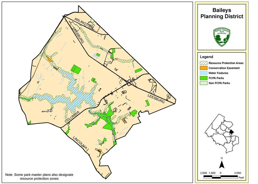
GREAT PARKS, GREAT COMMUNITIES
                               2010 – 2020 Park System Plan

                                         Fairfax County Park Authority

BAILEYS PLANNING DISTRICT

Location & Character....................................................................................................... 1
Park System Summary.................................................................................................... 1
Park Classification ........................................................................................................... 5
Park Master Plans ........................................................................................................... 7
Themes, Issues and Strategies ....................................................................................... 7
  THEME: Connectivity................................................................................................... 7
  THEME: Community Building .................................................................................... 11
  THEME: Service Delivery .......................................................................................... 12
  THEME: Facility Reinvestment .................................................................................. 15
  THEME: Land Acquisition .......................................................................................... 16
  THEME: Resource Interpretation ............................................................................... 18
  THEME: Cultural Resource Stewardship ................................................................... 19
  THEME: Natural Resource Stewardship.................................................................... 20

Maps, Figures, and Tables
Map 1: Public Parks by Class in the Baileys District........................................................ 3
Map 2: Regulatory Protections on Land in the Baileys District ........................................ 4
Map 3: Connections and Points of Interest in the Baileys District ................................. 10
Table 1: Parks in the Baileys Planning District ................................................................ 6
Table 2: Baileys Planning District 2020 Facility Needs Analysis ................................... 13
Table 3: Baileys Planning District 2020 Parkland Needs Analysis ................................ 16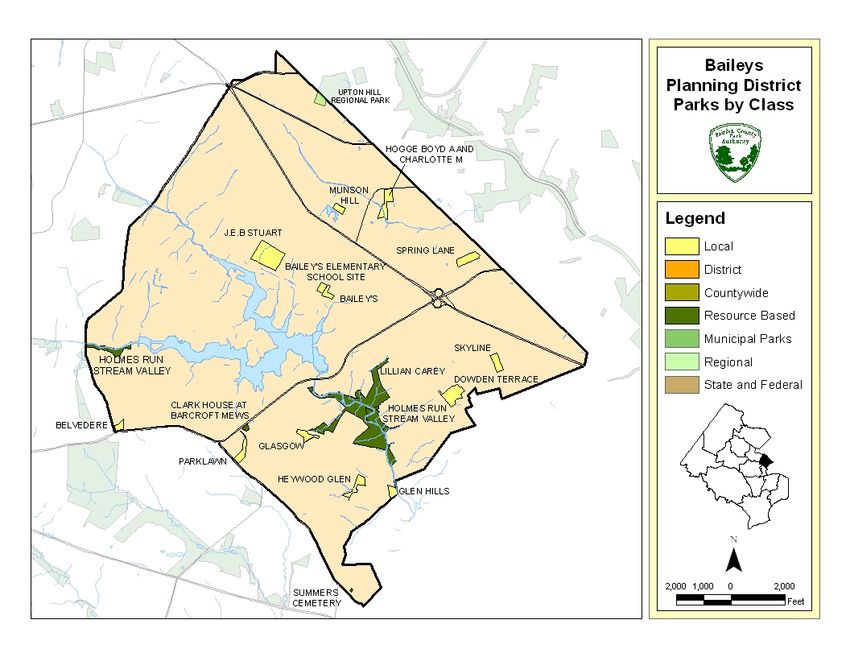
GREAT PARKS, GREAT COMMUNITIES - BAILEYS
May 2011
BAILEYS PLANNING DISTRICT
Location & Character
The Baileys Planning District is located in the eastern
portion of Fairfax County. It is adjacent to the City of
Alexandria, Arlington County and City of Falls Church
and shares overlapping service areas with recreation
facilities offered in all three adjacent jurisdictions.
This planning district is one of the earliest settled portions of the
county and is intensely developed. It has the highest population
density (13.2 persons/acre), among planning districts. It also
stands out demographically as one of the most diverse, with the highest
percentage of Hispanic (30.4%) and multi-racial (22.5%) residents of all of the
planning districts.
Park System Summary
Map 1 depicts the public parkland in the Baileys Planning District. There are 18 public
parks with a total of about 145 acres in the district. These parks make up about 3.6
percent of the total acreage of the district. Nearly all the public park acreage in the
district is owned by the Park Authority and is within Park Authority Maintenance Area 2.
Other parkland, at Upton Hill Regional Park, is owned by the Northern Virginia Regional
Park Authority (NVRPA).
The parks in the district include historic sites, local- and district-serving recreational
facilities, and stream valleys. Facilities include rectangle and diamond ball fields, tennis
and multi-use courts, volleyball courts, playgrounds, trails and picnic facilities.
J.E.B. Stuart Park is the largest sports-oriented park in Baileys. It provides a recently
upgraded diamond field, four tennis courts, a playground, picnic area and basketball
court. At over 58 acres, Lillian Carey Park is the largest park in the district and
surrounds Holmes Run Stream Valley. Only a small portion of this sprawling local park
is developed with facilities, since 90% of the park contains steep slopes and is within a
Resource Protection Area (RPA). The Clark House at Barcroft Mews Park is a 1902
Victorian farmhouse that has been restored and is available for rental.
Much of the development in the Baileys district occurred prior to the establishment of
the Park Authority. As a result of this early development, the amount of parkland in this
district is less than other areas of the county, even though the population density is
greater. This development pattern results in a shortage of all types of parkland and
therefore many recreational services for residents of this planning district are provided
by parks outside the district. Opportunities to add to existing parkland in Baileys are
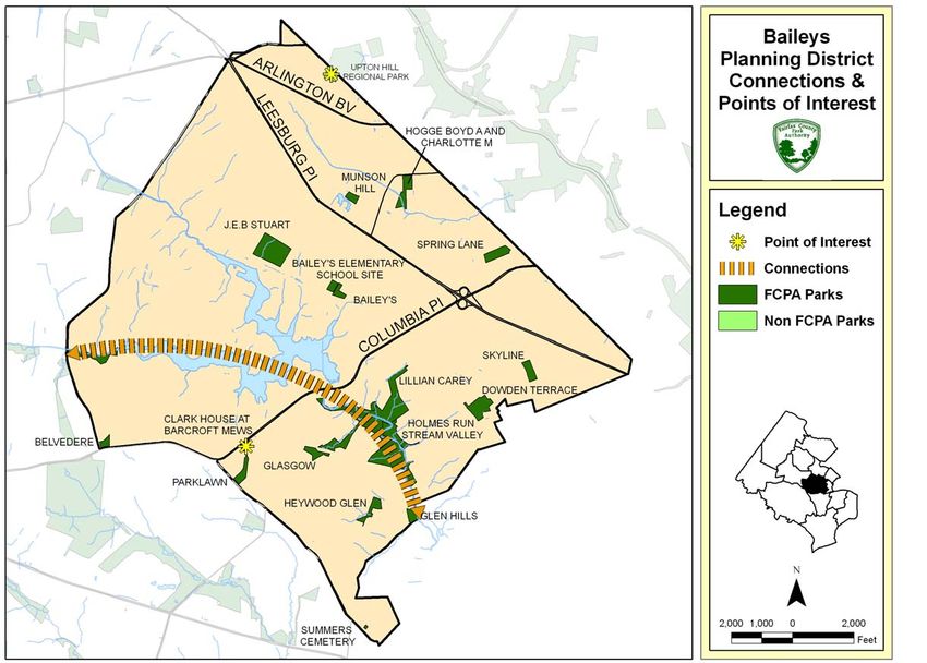
limited, due to the densely developed nature of the district. Map 2 identifies parkland
and areas that contain regulatory or other protections including public park ownership,
1GREAT PARKS, GREAT COMMUNITIES - BAILEYS
May 2011
conservation easements, and Chesapeake Bay Ordinance designated Resource
Protection Areas (RPA).
2GREAT PARKS, GREAT COMMUNITIES PLAN – BAILEYS
May 2011
Map 1: Public Parks by Class in the Baileys District
3GREAT PARKS, GREAT COMMUNITIES PLAN – BAILEYS
May 2011
Map 2: Protected Land in the Baileys District
4GREAT PARKS, GREAT COMMUNITIES PLAN – BAILEYS
May 2011
Park Classification
In June 2005, a new Park Classification System was adopted and incorporated into the
Park and Recreation chapter of the Countywide Comprehensive Policy Plan. The Park
Classification System is a general framework intended to guide open space and public
facilities planning by grouping parks according to certain common typical
characteristics. The park classification gives an indication of the intended use, general
park size range, typical facility types, and the general experience a user may expect at
a park:
Local Parks serve surrounding neighborhoods and communities and offer a
variety of local-serving recreation opportunities, such as playgrounds, trails,
athletic facilities, picnic areas and natural areas. Typically these parks are
designed to serve up to a 3 mile radius depending on the facilities and can range
from 2 to 50 acres in size.
Local parks may be urban or suburban in character. Urban parks (including
pocket parks, civic plazas and common greens) are a type of local-serving park
that are generally more compact and located within an urban or transit-oriented
setting. These parks generally consist of high quality design and construction,
are well integrated into surrounding development, uses and the public realm and
primarily serve to define local urban character, support outdoor enjoyment, social
gatherings, recreation needs and special events. These parks may be privately
or publicly owned and are usually privately maintained.
District Parks are larger parks that serve greater geographic areas of the County
(3 to 6 miles) and provide a wide variety of indoor and outdoor recreation
facilities and park experiences. Generally, these parks are more than 50 acres in
size. These parks typically accommodate visits of up to a half day, longer
operational hours and a larger number of users. Many district parks also have
extensive natural areas.
Countywide Parks are larger parks that serve the whole County and provide a
variety of larger-scale indoor or outdoor recreation facilities, or both, and facilities
or resources that are unique within the County. Typically, these parks are greater
than 150 acres and provide opportunities for passive and active recreation to a
wide range of simultaneous users for experiences of up to a day in length.
Resource-Based Parks have significant cultural and natural resources. These
parks support nature, horticulture and history programs, gardening, nature
watching and appreciation of local, regional, state and national history. Extensive
stream valley parks are part of the resource-based parks network. Typically, trails
and interpretative features and facilities are the primary uses. Some resource
parks may have separate areas designated for recreation purposes.
5GREAT PARKS, GREAT COMMUNITIES PLAN – BAILEYS
May 2011
Regional Parks are lands and/or facilities administered by the Northern Virginia
Regional Park Authority (NVRPA). These parks have region-wide significance
that supplement and enhance the County and municipal park systems.
While some parks are Resource-Based, note that all park types may include areas
designated for natural and/or cultural resource protection. In addition, many state and
federal parks augment local and regional parks and also serve to protect natural and
cultural resources within the County. Table 1 lists and classifies the parks in the Baileys
district according to the County parks classification system or by state or federal
ownership. Table 1 also includes information about whether and when parks were
master planned and if a master planning action (new master plan development or plan
update) is needed.
Table 1: Parks in the Baileys Planning District
Master
Approved Plan
Supervisor Park Master Action
Park Name Acres District Classification Plan Date Needed
Baileys 2.24 MA Local 1976
Baileys Elementary School^ 1.84 MA Local
Belvedere 1.83 MA Local 1976
Boyd & Charlotte Hogge 6.10 MA Local 2011
Clark House at Barcroft Mews 0.85 MA Resource-Based 1987*
Dowden Terrace 8.61 MA Local 1970
Glasgow 4.31 MA Local 1980
Glen Hills 2.53 MA Local
Heywood Glen 4.27 MA Local 1977
1 +
Holmes Run S.V. 129.91 PR, MA Resource-Based
J.E.B. Stuart 17.98 MA Local 2009
Lillian Carey 58.06 MA Resource-Based 1978
Munson Hill 2.22 MA Local 1983
Parklawn 3.89 MA Local 1970
Skyline 4.00 MA Local 1994*
Spring Lane 5.21 MA Local 1977
Summers Cemetery 0.40 MA Resource-Based
+
Upton Hill Regional Park 27.00 MA Regional N/A
1. Resource-Based Stream Valley parks by practice do not have master plans.
* This park was dedicated by a private developer and may be subject to a Conceptual Development Plan
associated with an approved rezoning that takes the place of a park master plan.
+ A portion of this park lies outside of the Baileys district.
^ School Sites operated on an interim basis as parks by the Park Authority do not have master plans as
they are owned and governed by the Fairfax County Public Schools.
Acreages for non-FCPA parks are estimates derived from GIS.
6GREAT PARKS, GREAT COMMUNITIES PLAN – BAILEYS
May 2011
Park Master Plans
A park master plan is a general guide for appropriate park uses and their approximate
location within a specific park site. The plan serves as a long-range vision (10-20 year
timeframe) for future development and programming. Issues typically addressed include
planned park elements, natural and cultural resource management, and general design
concerns. The plan is conceptual in nature and not intended to address detailed issues
related to engineered site design or park operations. The plan is just one of many steps
in the process that leads to the development of a public park. An archive of park master
plans is available at www.fairfaxcounty.gov/parks/plandev/mparchives.htm.
Themes, Issues and Strategies
In early 2008 the Park Authority interacted with citizens at ten Great Parks, Great
Communities public workshops in all Supervisory districts and at a variety of community
festivals and events in the parks to gather input on long-term planning for the land,
facilities and natural and cultural resources of the park system. In addition, the
Park Authority received public feedback on the park system throughout the year via
email and the project web site.
Based on the public feedback and staff expertise, staff identified 26 key issues that fit
within eight themes relating to the land, resources and facilities of the Park Authority.
The themes are Connectivity, Community Building, Service Delivery, Facility
Reinvestment, Land Acquisition, Resource Interpretation, Cultural Resource
Stewardship and Natural Resource Stewardship.
This section describes how the eight themes relate to the park system in the Baileys
District and presents strategies for addressing the issues as they apply to the parks in
the district. Some strategies include recommendations for construction of facilities,
infrastructure and amenities at parks in the district. As part of the planning process for
any proposed construction, the project area should first be assessed for possible
impacts to natural and cultural resources.
THEME: Connectivity
Better integrating parks with surrounding land uses (neighborhoods and employment
centers) and increasing park-to-park connections within the system will allow for greater
access and enjoyment. Strategy suggestions include adding trails, trail connections,
bridges and other forms of improved access to and between parks.
Map 3 illustrates existing and planned connections and points of interest within the
Baileys Planning District. The map depicts high-level, conceptual connections and
incorporates elements from the adopted Countywide Trails Plan and Park Authority Trail
Strategy Plan. Connections link natural and cultural resources and recreational
7GREAT PARKS, GREAT COMMUNITIES PLAN – BAILEYS
May 2011
destinations, supporting recreational activity and frequently offering alternative
transportation options.
Issue: The Park Authority should work to improve non-motorized access to parks
from commercial and residential areas and to increase connectivity between park
sites.
There is only one stream valley trail corridor within Baileys, as Heard from the
identified on the County Comprehensive Trail Plan, for off-road trail public: “There is
locations. This trail corridor runs through the Holmes Run Stream investment in
Valley Park. This stream valley includes Lake Barcroft, which was providing
created in 1915 by damming Holmes Run at its confluence with Tripps pathways within
Run. Lake Barcroft is privately held and serves as a members-only the park, but not
recreational area for residents of the Lake Barcroft residential always to the
community. A public connection would allow for the completion of the surrounding
neighborhood.”
Holmes Run Stream Valley Trail upstream and downstream from Lake
Barcroft.
The transportation system which runs within this area significantly impedes
development of non-motorized trail connections. The small number of parks and
distance between them also preclude connectivity between parks through parkland,
which is the primary route in many other planning districts. Columbia Pike (Rt. 244),
Arlington Boulevard (Rt. 50) and Leesburg Pike (Rt. 7) separate the planning district into
five distinct areas between which those routes form significant barriers to connectivity.
The City of Alexandria’s trail system within Holmes Run Stream Valley provides an
opportunity for connection with Fairfax County trails.
Strategies:
B-C-1. Use criteria provided in the Park Authority’s Trail Strategy Plan to evaluate
potential new trails, connections and improvements;
B-C-2. Encourage and assist County staff to work with the Lake Barcroft Association to
pursue public accessibility to the trail system in and around Lake Barcroft in a way
that would protect the property and security of the Lake Barcroft residential
community and provide a link between Fairfax County stream valley parkland south
of Columbia Pike and Holmes Run Stream Valley trail west of Lake Barcroft; and
B-C-3. Support City of Alexandria efforts to connect Park Authority and City of
Alexandria trail systems at Glen Hills Park/Holmes Run.
Issue: Multiple, separate park sites located across Fairfax County should be
linked through thematic interpretive connections.
Thematic connections, emphasized through elements such as signage, maps, or
website information, can foster greater public awareness of important features.
8GREAT PARKS, GREAT COMMUNITIES PLAN – BAILEYS
May 2011
Increased knowledge of site features could encourage greater support for stewardship
and management activities.
Strategies:
B-C-4. Add the Clark House at Barcroft Mews to an interpretive trail that links the site to
other historic structures within Fairfax County that illustrates changing architectural
styles through the County’s development; and
B-C-5. Include the Holmes Run Stream Valley as a significant node along a natural
areas interpretive trail within the county.
Issue: Park facilities should be served by the public transportation system to
provide access to recreational facilities.
Almost all of the parks in the Baileys district are within a half-mile of existing Metrobus
routes. Only portions of the Holmes Run Stream Valley Park are outside this distance.
While it may appear that all of the parks in the district are currently well served by public
transportation, they are not, due to stop locations and transit schedules.
Transit stops may be located farther away from parks than a half-mile, or across busy
streets where safe crossing may be an issue. While there is some limited weekend
transit service, the majority of the transit in the area is to support morning and evening
commuting with flows to and from the Metro stations being a primary goal. Transit
supporting commuting times and patterns do not necessarily serve park users who wish
to use parks.
Strategies:
B-C-6. Work with the Department of Transportation to improve bus transit service to
parks in the Baileys Planning District, especially Lillian Carey and Holmes Run
Stream Valley, where non-motorized trails exist. This should include coordination
with bus stop locations and transit schedules.
9GREAT PARKS, GREAT COMMUNITIES PLAN – BAILEYS
May 2011
Map 3: Non-motorized Connections and Points of Interest in the Baileys District
10GREAT PARKS, GREAT COMMUNITIES PLAN – BAILEYS
May 2011
Issue: The Park Authority should work to improve access to waterways and
promote the use of “water trails” throughout the County.
Since there are no navigable waterways in the district, no district- or park-specific
strategies exist for this issue in the Baileys Planning District.
THEME: Community Building
Local parks are places where people can interact and build community. Well-designed
and located parks, park facilities and programs support greater social interaction.
Community-building park facilities and activities include reservable picnic areas,
amphitheaters, dog parks, garden plots, farmers markets, performances and special
events. Collocation of facilities with other community uses can also assist in
strengthening communities. Strategy suggestions include ways to increase the
community-building role of local parks in residential neighborhoods and providing parks
and recreation facilities near other civic uses.
Issue: Local and urban parks should include a combination of facilities, amenities
and gathering spaces to attract and promote social interaction among community
members.
Baileys has the highest population density of all the districts in the county and many
high-density residential buildings, where residents do not have private yards. Outdoor
community spaces for people and dogs are needed to provide casual leisure
opportunities and to build community.
A few parks in the Baileys Planning District provide community building facilities that
help to promote social interaction and better integrate local parks with the surrounding
community. Dowden Terrace and Lillian Carey Parks have picnic shelters and many
other parks have picnic tables and playgrounds. Reservable picnic shelters are not
available within this planning district, nor are there any other facilities that would serve
large family or community gatherings within these parks.
There are no amphitheaters, dog parks, garden plots, farmers markets, or performance
and special event spaces in the Baileys district, although nearby Mason District Park in
the Annandale Planning District provides most of these types of facilities.
Strategies:
B-CB-1. Explore possibilities for providing a neighborhood-scale off-leash dog area; and
B-CB-2. Consider adding reservable picnic shelters and community gathering spaces;
perhaps in conjunction with other public buildings.
11GREAT PARKS, GREAT COMMUNITIES PLAN – BAILEYS
May 2011
Issue: Parks should be collocated with other civic uses (libraries, community
centers, senior centers, etc.) to promote social interaction among community
members.
Many existing parks are located with other public facilities. Community centers, libraries,
and all types of schools are adjacent to various parks within the Baileys Planning
District. The collocation of these facilities allows for some access and parking to be
combined in one location (as at Baileys Park). This also allows for the parks to provide
supporting recreational uses, such as the provision of trails and picnic areas in Lillian
Carey Park for the Baileys Community Center.
J.E.B. Stuart Park is adjacent to J.E.B. Stuart High School and the diamond field is
utilized by school teams. Belvedere and Baileys parks are adjacent to identically named
elementary schools and provide recreation and outdoor space for the schools as well.
Baileys Park is adjacent to the Woodrow Wilson Community Library and provides
outdoor space for library users.
Strategies:
B-CB-3. Add recreational facilities and amenities, where appropriate, to parks in the
district that are collocated with other civic uses; and
B-CB-4. Strengthen use relationships between parks and adjacent civic spaces.
THEME: Service Delivery
The Park Authority provides quality facilities that are well used, but may not be equitably
distributed across all parts of the County or accessible to all groups. Countywide and
specialty facilities, in particular, may not serve a true county-wide service area.
Residents desire recreational facilities and opportunities at parks near where they live
and for all age groups and socio-economic populations. Strategy suggestions include
creating more facilities, better distributing facilities across the County, and reducing
barriers to use.
Service level standards for over twenty park facility types were established through the
2004 Needs Assessment (http://www.fairfaxcounty.gov/parks/needsassessment.htm)
process and incorporated into the Countywide Policy Plan
(http://www.fairfaxcounty.gov/dpz/comprehensiveplan/policyplan/parksrec.pdf) in 2005.
Facility standards are countywide goals for providing park and recreation facilities that
reasonably satisfy community needs. Standards are expressed in units per population,
and are based on extensive analysis of citizen demand and preferences compared with
the existing public facility inventories. Based on the Countywide adopted facility service
level standards and projected population growth, Table 2 shows the projected surplus or
deficit of several key local serving facilities in the Baileys Planning District for the year
2020. While overall facility needs are quantified in Table 2, the location of needed
facilities is determined through the site specific master planning process that considers
12GREAT PARKS, GREAT COMMUNITIES PLAN – BAILEYS
May 2011
site conditions, context, resources, and community input. For more detailed information
on existing facilities in each park and service levels, please see the Existing Conditions
Report.
Table 2: Baileys Planning District 2020 Local Serving Facility Needs Analysis
45,847 2010 population
46,491 2020 population
2020
2010 2020 2020 Projected
Existing Needed (Deficit)/ Service
Facility Service Level Standard Facilities Facilities Surplus Level
Rectangle Fields 1 field / 2,700 people 11.2 17.2 (6.0) 65%
Adult Baseball Fields 1 field / 24,000 people 1.0 1.9 (0.9) 52%
Adult Softball Fields+ 1 field / 22,000 people 0.0 2.1 (2.1) 0%
Youth Baseball Fields+ 1 field / 7,200 people 4.0 6.5 (2.5) 62%
Youth Softball Fields+ 1 field / 8,800 people 0.0 5.3 (5.3) 0%
Basketball Courts 1 court / 2,100 people 4.5 22.1 (17.6) 20%
Playgrounds 1 playground / 2,800 people 12.5 16.6 (4.1) 75%
Neighborhood Dog
Parks 1 dog park / 86,000 people 0.0 0.5 (0.5) 0%
Neighborhood Skate
Parks 1 skate park / 106,000 people 0.0 0.4 (0.4) 0%
+
60 ft and 65 ft diamond fields are assigned to the sport where primarily allocated.
Issue: The Park Authority should provide and equitably distribute facilities to
meet established facility service level standards.
There is a severe shortage of athletic fields, particularly rectangular fields, in the Baileys
district. Mason District and Jefferson District Parks are large parks that provide a
significant number of fields and recreational amenities. Both are located outside of the
Baileys district, but do serve a portion of the recreation needs of the area. The district is
also served by Upton Regional Park, administered by the Northern Virginia Regional
Park Authority (NVRPA).
A synthetic turf rectangle field with diamond overlay was recently completed at Bailey’s
Elementary School. This field will better serve community and school needs and better
withstand heavy use than a grass field. Unlike other planning districts, there are no
athletic courts or field facilities in this district that are planned but not constructed.
13GREAT PARKS, GREAT COMMUNITIES PLAN – BAILEYS
May 2011
Strategies:
B-SD-1. Coordinate with NVRPA to allow Fairfax County to include fields at Upton
Regional Park in the Neighborhood and Community Services (NCS) scheduling
system;
B-SD-2. Consider adding court facilities and complexes at local parks in the district to
address the deficiency of local-serving athletic courts;
B-SD-3. Pursue partnerships with schools to improve field quality and increase public
access to school athletic facilities;
B-SD-4. Explore the possibility of adding a neighborhood skate park facility to one of the
parks in the district; and
B-SD-5. Seek proffered funding and/or development of athletic facilities through the
development process.
Issue: The Park Authority should provide new kinds of parks and facilities and in
new ways to meet the needs of the County’s changing population.
The Baileys district is home to a large immigrant community. These Heard from the
residents have different needs and customs with regard to their use public: “There is a
of park spaces than American-born residents that tend to extend use need for more open
for longer periods of time and for larger groups. Parks with large, and unscheduled
flexible spaces that may be used for family gatherings, celebrations, play areas that
special events, and local markets might better serve immigrant don’t require use
residents’ needs than traditional park facilities. permits.”
Strategies:
B-SD-6. Continue to develop relationships with immigrant communities in the district and
seek their input on providing appropriate park facilities and spaces to meet their
recreation needs.
Issue: The Park Authority should re-examine park master plans to determine if
parks are planned to best serve the needs of Fairfax County residents.
Most of the parks in the district have existing master plans. Most of these master plans
are over 30 years old and planned with facilities that may not best support adjacent
residential uses. Some sites, such as Lilian Carey Park, offer the opportunity to expand
local park usage by conversion of older, less popular facilities (horseshoe pits, sand
volleyball court) to newer facilities that will better meet the needs of the community.
Strategies:
B-SD-7. Consider revising the master plan for Lilian Carey Park to allow for
development of new or different recreational facilities to meet the needs of Baileys
residents; and
14GREAT PARKS, GREAT COMMUNITIES PLAN – BAILEYS
May 2011
B-SD-8. Look for opportunities to create single activity-oriented parks (such as a tennis
court complex) that will create sport destination parks within the district that would
support league and drop-in sport participation.
THEME: Facility Reinvestment
The Park Authority has a diversity of facilities and resources in various lifecycle stages.
Funding and schedules for replacement or reinvestment are inconsistent and adding
new facilities has sometimes taken precedence over renewal of existing facilities.
Strategy suggestions include repairing, replacing, upgrading, and improving utilization of
existing facilities and equipment.
Issue: Repair, replacement, and upgrading of existing park facilities should be
addressed through a system-wide lifecycle replacement program that takes into
account changing facility needs.
Strategies:
B-FR-1. Replace playground equipment at Parklawn
Park; Heard from the public: “I
B-FR-2. Renovate or enhance the playground areas would like to see an emphasis
placed on the cleanup and
at Dowden Terrace and Munson Hill Parks;
maintenance of existing parks
B-FR-3. Collocate play equipment for the full age- and trails. When we brag on
range of children wherever possible to increase our public parks and facilities,
use of playgrounds by the community; and they must be clean and well-
maintained – top notch.”
B-FR-4. Continue neighborhood partnerships to
reinvest in local parks, such as those that have
taken place at Munson Hill and Parklawn Parks.
Issue: Parking standards and levels of service should reflect user patterns to
minimize impacts on surrounding neighborhoods.
Due to the dense residential nature of the district, there can be parking conflicts
between local residents and park users arriving by automobile.
Strategies:
B-FR-5. Develop all local parks in a way that encourages non-motorized access to the
surrounding residential areas; and
B-FR-6. Promote shared access and parking agreements when parks are adjacent to
other civic uses, such as places of worship, libraries or schools.
15GREAT PARKS, GREAT COMMUNITIES PLAN – BAILEYS
May 2011
THEME: Land Acquisition
Additional parkland is needed to protect and buffer natural areas and historic sites and
to provide room to develop new recreational facilities. Strategy suggestions include
ways to continue to add appropriate land to the Park Authority’s land holdings to expand
the park system.
Service level standards for both local and district/countywide parkland were established
through the 2004 Needs Assessment and incorporated into the Countywide Policy Plan
in 2005. Parkland standards represent countywide goals for providing land for the two
types of parks (Local and District/Countywide) that support service delivery and facility
development and are expressed in units per population. Local parks include both
suburban and urban park types. Resource-based parks occur where resources are
located and therefore do not require quantitative service level standards. Please refer
to the Park Classification discussion earlier in this chapter for additional information on
park classification descriptions.
Based on adopted service level standards and projected population growth, Table 3
shows the projected surplus or deficit of parkland in the Baileys Planning District for the
year 2020.
Table 3: Baileys Planning District 2020 Parkland Needs Analysis
45,847 2010 Population
46,491 2020 Population
4,047 District Size (acres)
2010 2020 2020 2020
Parkland/Open Service Level Existing Needed (Deficit)/ Service
Space Type Standard Acres Acres Surplus Level
Public
Parkland Local Suburban 5 acres / 1,000 people 122 232 (110) 52%
1.5 acres / 1,000 people
plus 1 acre/10,000
Urban employees
+
District/Countywide 13 acres / 1,000 people 3 604 (601) 0.5%
Resource-Based * 20
Parkland Total 145
Private Private Recreation 0
Open HOA Property 216
Space
Private OS Total 216
Public & Private Total 361
+ The District and Countywide Parks that serve this Planning District may be located outside the Planning
District and this outlying acreage is not reflected in this table.
* There is no service level standard for Resource-Based parkland. The amount of resource based
parkland owned and/or protected is based on the existence and sensitivity of the resources.
16GREAT PARKS, GREAT COMMUNITIES PLAN – BAILEYS
May 2011
Issue: Parkland for recreation should be provided according to adopted service
level standards and distributed equitably throughout the County.
Due to the existing dense development within Baileys, there are few opportunities to
purchase land suitable for park facilities. Therefore the most likely source of new
parkland to address the service level deficiencies will come from infill development and
redevelopment within commercial areas or from outside the Baileys district.
Improvements to schools, libraries, and community centers may offer opportunities to
improve existing parkland or create new parks.
Strategies:
B-LA-1. Seek land dedications to create additional local serving parks with infill
development and redevelopment; and
B-LA-2. Consider adding or improving parks and public recreation uses when other
public properties are redeveloped and/or renovated.
Issue: Urban parks should be provided in higher density/mixed use areas of the
County (i.e. Tysons Corner, Transit Station Areas, Commercial Revitalization
Districts).
The Bailey Crossroads and Seven Corners Commercial Revitalization District (CRD) is
an area of the county targeted for revitalization and higher density mixed use
developments. While Parklawn Park is the only park within the CRD area, there are an
additional seventy acres of parkland within 0.5 miles of the CRD. Some of these parks
are within walking distance of the CRD and should be viewed as contributing elements
to support revitalization efforts within the CRD. Primary among these are J.E.B. Stuart,
Dowden Terrace, and the Boyd and Charlotte Hogge parks. Additional urban park
opportunities have been identified within the Baileys Core Area plan that will serve
growth in this area and provide essential placemaking elements.
Strategies:
B-LA-3. Encourage rezoning applicants to provide turnkey urban parks and recreational
facilities in the growth areas of Baileys Crossroads and Seven Corners to serve new
residents and employees that will be concentrated there; and
B-LA-4. Encourage new development in the Baileys and Seven Corners CRD to provide
improvements to existing parks in the district.
Issue: Property acquisition is important for protecting cultural resources in
Fairfax County and ensuring their preservation for future generations.
Strategies:
B-LA-5. Seek to acquire and/or protect through purchase, donation, development
dedications, public access easements or conservation easements remaining natural
17GREAT PARKS, GREAT COMMUNITIES PLAN – BAILEYS
May 2011
areas in the district, especially urban parks and large tracts connecting to other
natural areas and those containing unique or significant natural resources.
Issue: Property acquisition is an important strategy for protecting natural
resources in Fairfax County and ensuring open and natural areas for future
generations.
Most of the natural and cultural resource areas in the Baileys district have been
developed or are impinged by existing development. A large portion of Lillian Carey
Park contains natural areas that support the Holmes Run Stream Valley ecosystem.
Strategies:
B-LA-6. Continue to seek opportunities to acquire property within the Holmes Run
stream valley, in accordance with the stream valley policy.
THEME: Resource Interpretation
Residents may not be aware of or understand the importance of the vast number of
natural and cultural resources the Park Authority holds in public trust. Strategy
suggestions include adding to the existing interpretive facilities, signs, and programs.
Roadway and trail waysides permit park visitors opportunities to stop and view
interpretive signage.
Issue: The full range of natural and cultural resources within Fairfax County
should be interpreted through facilities as needed.
When compared to other planning districts, parkland within the Baileys District has
limited natural resources. Holmes Run Stream Valley and Lillian Carey parks comprise
the majority of the natural resources in the district. These resources are primarily related
to the water resources of the stream valleys and the large non-fragmented forested
areas of these parks. Most of the remaining parks in the district have fragmented natural
areas.
The Baileys Planning District has many important cultural resources. The most
important of these are Civil War features and Native American sites. Native American
sites exist in abundance in the undeveloped portions of our park lands. Historic sites in
county parks in the district reflect different phases of the architectural and agrarian
history of Fairfax County during the 18th, 19th, and 20th centuries. They provide
opportunities to interpret the evolution of Fairfax County from colony through the
Revolution, Civil War and into the period of the New Nation.
Strategies:
B-RI-1. Provide appropriate cultural resource signage and interpretive facilities at Clark
House, Summers Cemetery, Munson Hill, Skyline, and Parklawn Parks.
18GREAT PARKS, GREAT COMMUNITIES PLAN – BAILEYS
May 2011
THEME: Cultural Resource Stewardship
Many factors threaten the health, protection and viability of natural and cultural
resources on county parkland. Strategy suggestions include focusing on managing
threats and actively managing existing natural and cultural resources consistent with
guidance provided in the countywide Cultural Resource Management Plan and Natural
Resource Management Plan.
Heard from the public: “We
Issue: Historic structures should be stabilized, repaired, have a great park system and
renovated and/or restored to ensure their preservation serve a diverse constituency,
and availability for public viewing and interpretation. but most of our natural
resources are destroyed or
Some of the important historic resources in the district are the impaired. FCPA should take
Clark House at Barcroft Mews, The Summers Cemetery, and the lead in creating,
Munson Hill. restoring and acquiring
more natural areas.”
Strategies:
B-CR-1. Restore, preserve, and maintain the Clark House;
and
B-CR-2. Evaluate the condition of Summers Cemetery and surrounding fence and gate,
repair and reinstall gravestones currently housed at the James Lee Center, and
replace any missing gravestones, where possible.
Issue: Cultural Resources should be identified and evaluated prior to any
proposed construction activity.
Strategies:
B-CR-3. For any site subject to proposed construction activity, a preliminary
assessment of the property will be carried out using GIS and pedestrian
reconnaissance. Should potential resources be present, a cultural resource survey
will be conducted and mitigation measures will be developed, as necessary.
Issue: Impacts to National Register eligible cultural resources should be avoided
where at all feasible. If impacts cannot be avoided mitigation level
documentation or data recovery should occur.
Strategies:
B-CR-4. Document and record buildings and structures using Historic American
Buildings/Historic American Engineering methods (research, measured drawings
and archival photographs) and conduct data recovery excavations for archaeological
sites, as appropriate.
19GREAT PARKS, GREAT COMMUNITIES PLAN – BAILEYS
May 2011
Issue: New, expanded, and upgraded facilities are needed to house artifact
collections to ensure their preservation for future generations.
No district- or park-specific strategies exist for this issue in the Baileys Planning District.
This is an issue of countywide concern that should be addressed with centralized
facilities.
THEME: Natural Resource Stewardship
The natural areas of the district are extremely fragmented, with significant portions of
edge and few large tracts remaining. Most of the natural areas are concentrated in the
low-lying lands since many of the uplands have been converted to built features.
Transportation and utility corridors and other easements crisscross natural areas, often
resulting in less than ideal management practices. Neighborhoods are located too close
to existing wildlife corridors for movement of animal and plant species. This also has the
effect of increasing citizen/wildlife conflict and limiting natural migration in these
corridors.
Issue: Natural habitats and the wildlife they support are disappearing and are
fragmented.
Strategies:
B-NR-1. Seek to acquire and protect remaining natural areas in the district;
B-NR-2. Protect and improve existing corridors, linkages, and watersheds;
B-NR-3. Provide new linkages between remaining public and private natural areas;
B-NR-4. Manage utility corridors and other easements consistent with natural resource
goals, not just utility service goals; and
B-NR-5. Designate permanent resource protection zones on parkland that define
appropriate uses and development.
Issue: Water resources and stream valleys are degraded due to development and
associated stormwater runoff.
Strategies:
B-NR-6. Work with the Department of Public Works and Environmental Services
(DPWES) and private land owners to capture and treat stormwater. This could take
the form of incorporating Low Impact Development (LID) methods on residential and
commercial lots and renovation of larger properties to provide new or enhanced
stormwater facilities;
B-NR-7. Encourage private property owners to adopt wildlife and water friendly
landscaping practices to improve water quality and habitat.
20GREAT PARKS, GREAT COMMUNITIES PLAN – BAILEYS
May 2011
Issue: The Park Authority does not have an adequate inventory of natural
resources on parkland.
Strategies:
B-NR-8. Direct development of park infrastructure to areas that, when inventoried,
reflect few or poor quality natural resources, unless otherwise incompatible;
B-NR-9. Ensure that natural resources are assessed prior to any park development.
Use design principles that minimize natural resource impacts and include monitoring
and restoration of impacted natural areas as part of development plans; and
B-NR-10. Conduct natural resource inventories, develop, and implement natural
resource management plans for natural areas, especially within the Holmes Run
stream valley corridor.
Issue: Non-native invasive plants are threatening natural resources by reducing
the diversity of native species and impacting wildlife habitat.
The extremely fragmented nature of the natural areas in the district coupled with small
park size and high levels of human disturbance have generally resulted in degraded
natural areas within parks with high occurrences of invasive plant species. Due to the
mature nature of the urban and residential development in the Baileys area, invasive
plant species are well established and often cover large percentages of vegetated
areas.
Strategies:
B-NR-11. Educate citizens on the problems associated with invasive plant species.
Work with them to eliminate or limit invasive plants on private property near parks
and to prevent new introductions of invasive species; and
B-NR-12. Expand non-native invasive plant management and habitat restoration on
parkland by implementing the Non-Native Invasive Plant Prioritization Plan and
Assessment.
Issue: The County has a goal to expand tree canopy. The Park Authority should
contribute to this goal wherever possible by ensuring existing forested areas are
sustainable and expanding canopy where possible.
Strategies:
B-NR-13. Ensure sustainability of tree canopy on parkland by developing and
implementing management plans and controlling threats such as non-native invasive
plants and deer herbivory;
B-NR-14. Encourage tree planting and natural landscaping techniques on private land;
B-NR-15. Incorporate natural landscaping techniques on parkland, avoid tree loss from
development and where possible increase tree canopy; and
21GREAT PARKS, GREAT COMMUNITIES PLAN – BAILEYS
May 2011
B-NR-16. Designate permanent resource protection zones on parkland that define
appropriate uses and development.
Issue: The Park Authority should utilize innovative practices in construction of
recreational facilities and buildings to minimize impacts to the environment and
demonstrate stewardship.
No district or park-specific strategies exist for this issue in the Baileys Planning District.
22You can also read