Urban Risk Reduction Through Effective Disaster Management Plan-A Case Study Of Shimla City, Himachal Pradesh, India
←
→
Page content transcription
If your browser does not render page correctly, please read the page content below
INTERNATIONAL JOURNAL OF SCIENTIFIC & TECHNOLOGY RESEARCH VOLUME 4, ISSUE 02, FEBRUARY 2015 ISSN 2277-8616
Urban Risk Reduction Through Effective Disaster
Management Plan-A Case Study Of Shimla City,
Himachal Pradesh, India
Bhavna Karki
Abstract: By 2050, 70% of the world‘s population will live in urban areas. In India the urban population has increased from 217 million to 377 million in
last two decades .With increasing population the associated risk and vulnerability has also increased. As cities continue to grow, there is increased
pressure on resources; exposure of lives, livelihoods and economic, social and environmental assets to risk is set to increase exponentially. Recognised
as one of the best cities for public services and one of the oldest Municipal Corporation in India, Shimla city is situated at the traverse spur of the Central
Himalayas at 31004' N to 31010' N latitude and 77005' E to 77015' E longitude, at an altitude of 2397.59 m metres amsl. This paper aims at underlying
the role of Shimla Municipal Corporation (SMC) as local government in managing disasters in the city along with effective planning and risk
assessments.
Key words: Shimla, governance, urban, disaster risk, exposure, vulnerability, plan
————————————————————
1. Introduction In spite of knowing and acknowledging the vulnerabilities
Population pressure on urban areas is increasing and increasing risks the administration has failed to address
exponentially in India. The government and authorities are many other aspects of disaster management in similar
facing challenges in managing cities and providing incidents that are frequent and regular. This paper aims to
inhabitants the facilities, services as well as a safer look into the preparedness level of the city of Shimla for
environment. Unplanned and haphazard development is risk, vulnerabilities and disaster management. Good urban
posing as a threat to the cities. This risk is further enhanced governance is characterized by transparent decision
in the changing climatic conditions. It is estimated that by making, sound financial management, public accountability,
2050, 70% of the world‘s population will live in urban areas. equitable resource allocation and probity, and should lead
In India the urban population has increased from 217 million to sustainable improvements in most urban indicators (MC
to 377 million in last two decades. This is expected to reach Shimla).The word sustainability could be linked to being
600 million, or 40 percent of the population by 20311 (New resilient. Shimla city is multi hazard prone and along with
Climate Economy Report, 2014). The disaster in year 2013 demographic change the city seems to be struggling to
in Kinnaur district Himachal and neighbouring state balance between development and sustainability. Apart
Uttarakhand and 2014 Jammu and Kashmir floods exposed from the city‘s population a floating population of close to
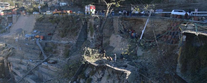
our unpreparedness in managing disasters. In Shimla too 75000 also demands the basic facilities. With limited
preparedness at city level was exposed in the response to resources, limited workforce and limited expertise, the 1
the recent caved in road segment (Picture 1). The New Climate Economy Report by the Global Commission
vulnerability of the city is also evident from some incidents on the Economy and Climate, 2014 at
like caving in of portion of road of about 40 m in length on http://newclimateeconomy.report/
the ridge in front of ‗Gaiety Theatre‘ Shimla, caved in by
about 1.8 m in monsoon in 2010, or the June 2012 heavy
rain collapsing a dozen houses in Krishna Nagar ward. As
per 2011 Census, Shimla is the only Class I City in the
State of Himachal Pradesh and is registering almost 20%
extra growth rate compared to similar other cities in India,
which is resulting in rapid development of real estates,
housing, complexes, shopping malls etc.
Picture 1: Cart Road Damage, Shimla
______________________________ (Source: Himachal Watchers)
Bhavna Karki, Environment and Disaster
city administration has been working with experts and
Management Professional. Address: E-30-D, MIG
consultants to work with them in better planning in all the
Flats,Street E,G-8 , Rajouri Graden ,Mayapuri,New
important spheres in making the city better, safer and more
Delhi-110064(India).
resilient. The city administration to some extent has started
Email Id: bhavnakarki@gmail.com
to recognize the issue of climate induced risks, safety and
67
IJSTR©2015
www.ijstr.org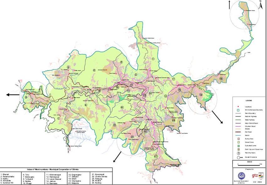
INTERNATIONAL JOURNAL OF SCIENTIFIC & TECHNOLOGY RESEARCH VOLUME 4, ISSUE 02, FEBRUARY 2015 ISSN 2277-8616
response especially in view of the high vulnerability of the and Bypasses
city to several hazards. However disaster management Internal Roads SMC SMC SMC
requires an effective planning and management and there Himachal
could be two focus area to start with: Pradesh State HPSEB/
Street Lighting SMC
Electricity Board SMC
a) Planning and management – This is to plan and (HPSEB)/SMC
manage today .Every development plan should SMC/Fire
integrate disaster management concern in their Fire Services SMC/Fire Dept SMC/Fire Dept
Dept
planning. Town and
b) Actions to mitigate the impact of any disaster in Open Country
SMC SMC
case of any disaster-This would include institutional Spaces/Parks Planning(TCP)
Department
strengthening and capacity building of concerned
Himachal
authorities for quick response. Pradesh Road
Transport
Any disaster impacts infrastructure, physical settlement, Corporation(HRT
failure of communication system, electricity supply, C) / HP Bus HRTC/ HRTC/
Transportation
drainage system etc. In the absence of a well- defined Stand HPBMDA HPBMDA
Management and
implementable disaster management plan a disaster can Development
create mass destruction. The plan should thus achieve the Authority
following objectives: (HPBMDA)
Resource inventory. Vertical Public Works
Tourism
Integration with other stakeholders and departments. Transport Department PWD
Department
(Elevator) (PWD)
Allocation of specific responsibilities to the various
Himachal
agencies involved. Pradesh housing
Response plan and designated responsibilities & Urban
Housing HIMUDA HIMUDA
during, before and after disasters. development
Effective management of the available resources. authority
(HIMUDA)
Developing the standard operating procedure for Basic Services
perfect co-ordination among various department and DoUD/SMC SMC SMC
to Urban Poor
relief agencies involved. Forest Forest Forest
Urban Forest
Department Department Department
The above mentioned components fulfill the primary criteria Public
I&PH/SMC NGO NGO
of drafting a plan. The concept behind the formulation of Conveniences
city disaster management action plan is to save the lives, Source: Municipal Corporation, Shimla
properties and environment: provided quick relief to the
affected area and restore the normalcy. The city has a For the human resource apart from the employees and
disaster management plan which was passed by General workers Municipal Corporation has the councillors who are
house of the Municipal Corporation in year 2012. This is the elected public representatives to look after their wards.
good start to work on because municipal corporation is the So the role and responsibility of Municipal Corporation is
nodal body that looks after the city and is responsible for foremost and it is the nodal agency for city level responses
water supply, sewerage, waste disposal, health, planning, to disaster situation and depending on the size of disaster
roads and maintenance of other amenities in the city (Table and if required the help of district authorities should be
1). It also contains the record of people, kind and type of sought later on. The present case study looks into the
housing, water supply connections, commercial settlements existing plan to show that the city district disaster
and so on. management plan is a multi response plan and outlines the
essential things required for managing any disaster
Table1: Institutional Framework for Planning & Design, situation. The plan is a step towards building resiliency.
Construction and Operation & Maintenance Resiliency here could be understood by the following
definitions:
Planning &
Services Implementing Agency
Design ―The ability of a system, community or society exposed to
Operations & *City SanitationPlan Shimla city, 2012
Construction
Management Hazards to resist, absorb, accommodate to and recover
Irrigation and
Bulk Water from the effects of a hazard in a timely and efficient
Public Health I&PH I&PH
Supply
(I&PH) manner‖ (United Nations International Strategy for Disaster
Water Supply Shimla Municipal Reduction)
and Corporation SMC SMC ―The ability of a social or ecological system to absorb
Distribution (SMC) disturbances while retaining the same basic structure and
Sewerage I&PH/SMC I&PH/SMC I&PH/SMC ways of functioning, the capacity for self-organisation, and
Drainage I&PH/SMC I&PH/SMC SMC the capacity to adapt to stress and change‖
Storm Water (Intergovernmental Panel on Climate Change)
I&PH/SMC I&PH/SMC SMC
Drainage
―The capacity of a system to absorb disturbance and
Solid Waste
Management
SMC SMC SMC reorganize while undergoing change‖ (The Resilience
Main Roads PWD PWD PWD Alliance )
68
IJSTR©2015
www.ijstr.org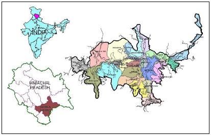
INTERNATIONAL JOURNAL OF SCIENTIFIC & TECHNOLOGY RESEARCH VOLUME 4, ISSUE 02, FEBRUARY 2015                         ISSN 2277-8616

Shimla city has an interesting history of its origin. Termed            of 19.55 square kilometres and has 25 municipal wards
as Summer capital of India by British, it was planned for a             (Map 2 ) .
capacity of 25000-30000 people due to limited resources
and space. Today the city has expanded unimaginably. The                          Hill Spur.                 Elevation (m).
pressure on resources, unplanned development and unsafe
practices all are making city mire vulnerable and it‘s high                      Jakhoo Hill                 2454
time to ensure the resiliency in the city. It is therefore
important for both administration and community to                               Elysium Hill                2257
understand the risk, recognise the changes and be
prepared.                                                                       Museum Hill                  2201

2. Objectives:                                                                  Prospect Hill                2177
To recommend actions for Urban Risk Reduction through
effective disaster management plan though Shimla city as a                     Observatory Hill              2150
case study.
                                                                                Summer Hill                  2104
3. Location:
The Municipal town of Shimla, the head quarter of the                            Potters Hill                2073
district and summer capital of India during British regime, is
situated on a range of entirely mountainous Middle                            Table 2: Hill Spurs & their Mean Elevation
Himalayas which forms the last traverse spur of the Central
Himalayas, south of the River Satluj. Geographically,
Shimla lies at 31004' N to 1010' N latitude and 77005' E to             4. Geology:
77015' E longitude, at an altitude of 2397.59 m metres                  Shimla town is situated on the rocks of Jutogh Group and
above msl (Picture 2). The existing town resembles an                   Shimla Group. Jutogh group occupies main Shimla area
irregular crescent with a 9.2 km extension from one end to              and extends from Annadale-Chura Bazar – Prospect Hill-
the other, covering a total area of 19.55 sq.km. Shimla town            Jakhoo-US Club and highland area. Shimla Group
is situated in a seismic belt (Seismic Zone IV) as per IS-              comprising of earlier Chail Formation and Shimla Series
1893.                                                                   represented by shale, slate, quartzite greywacke and local
                                                                        conglomerate is well exposed in Sanjauli-Dhalli area. It is
                                                                        also the headquarter of Shimla district and has important
                                                                        Government and non-government establishments including
                                                                        the State secretariat, district collectorate, High Court,
                                                                        Municipal Corporation.

                                                                        5. Climate:
                                                                        Chilly winds from the upper Himalayas make winters in
                                                                        Shimla cold. Around Christmas or last week of December
                                                                        Shimla gets snowfall. Temperature varies from 15 ~20ºC in
                                                                        summers and in winters its in the range 0~13ºC.

              Map 1: Location of Shimla City*

The eastern portion of the town is Chotta Shimla while the
extreme western side is called Boileauganj. An outlying
northern spur running at right angles to the main ridge is
Elysium Hill. Five and half kilometers from the western end
of the station is outlying hills of Jutogh. This town is spread
over seven hill spurs. The average elevation above mean
sea level and the name of the spurs are given below (Table
2). These spurs are interconnected by roads. The important
character of the road network circumscribing these hills is
that it is connected to the Mall road from Boileauganj to                     Map 2: Administrative Map of Shimla City**
Chotta Shimla. Situated at the traverse spur of the Central
Himalayas, south of the river Satluj the city is one of the
most vulnerable zone of the Himalaya The city has an area               **Source: Municipal Corporation, Shimla

                                                                                                                                 69
                                                             IJSTR©2015
                                                             www.ijstr.org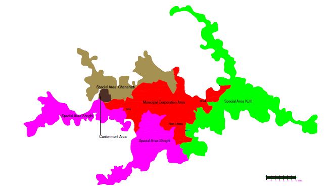
INTERNATIONAL JOURNAL OF SCIENTIFIC & TECHNOLOGY RESEARCH VOLUME 4, ISSUE 02, FEBRUARY 2015 ISSN 2277-8616
The average annual rainfall in the region is 900mm. Authorities of Kufri, Shoghi and Ghanahatti (Map 3 and
Table 4).
Climatic variations:
Increasing heat in summers, declining quantum of show in Map 3: Administrative boundaries: Shimla planning Area
winters, unusual behaviour of monsoon and frequent dry
spells are the prime climatic concerns. The highest
temperature during summer months of May-June goes
even more than 300 C. Temperature, however goes down
even – 400C during winters.
6. Governance:
As per HP Municipal Act, 1994, the key responsibility for
providing basic urban services in Shimla lies with Municipal
Corporation Shimla. These services include water supply,
sewerage, solid waste management, land-use planning,
construction and maintenance of internal roads, street
lighting, and primary health and education facilities. All
these services mentioned in section 12 of 74th
Constitutional Amendment Act are transferred to Municipal (Source: Department of Town and country planning,
Corporation Shimla except fire services and urban forestry. Shimla, HP)
Various state level agencies are involved in providing
various services in Shimla. Municipal Corporation Shimla 9. Regional Linkages:
has also used Public Private Partnership in various services Shimla is connected by road, rail and air. Shimla is
which include sewerage, solid waste management, public connected by road with Delhi (330 km), Chandigarh (117
convenience, transport. km) and Kalka (90 km). Shimla is connected by narrow
gauge railway line from Kalka (90 km). Shimla Airport at
7. Demographics: Jubbarhatti, 23 km from city is connected to Chandigarh,
The total number of households and population of M.C. Kullu and Delhi
Shimla is 46306 and 169578(Census 2011) respectively.
Out of total population, 93152 are males and 76426 are Table 4: Settlements Falling Within Planning Area
females. The Sex ratio is 756 females per 1000 males.
Area in
S.no. Settlement %
Floating Population hectares
As per Census analysis (Table 3), it has been observed that 1. M C Shimla 2207 22.18
2. SA Ghanahatti 1647 16.55
the growth rate of floating population has shown a little
3. S A Kufri 3173 31.89
downward trend, while the total number of floating 4. S A Shoghi 2923 29.38
population has increased due to Shimla being a service city Total 9950 100.00
as well as tourist destination.
10. Physical, Environmental & Hazard
Table 3: Floating population of Shimla-Existing and
projected Considerations
% Decadal growth 10.1 Hazard profile of the city:
Year Floating population City is prone to the following main hazards:
rate
1971 23459 36.00 Earthquake- Situated in zone IV it has the high risk of
1981 30000 31.74 earthquake which can further trigger other disasters like
1991 40000 31.70 landslides.
2001 56000 40.00
2011 76000 35.00
Landslide- The problem of landslides is common and
2021 100000 31.00 frequent in Shimla. Every year the city faces one or more
Source: Town and Country Planning Department, Shimla landslides affecting society in many ways. Loss of life,
damage to houses, roads, and means of communication
Population in the city is expected to grow because it being are some of the major consequence of landsides in the city.
an administrative and tourist city, it is anticipated that the Land Sinking- Recent geological studies indicate that
tertiary sector shall continue to function as a dominant roughly 25% of the old town is in the sinking zone, and
sector of economy by year 2021. As a result the workforce unless improvements are made in the drainage and
participation in this sector will increase. Secondly better sewerage systems ofthe upper reaches, more could go
opportunities will attract rural population towards the city. under. It is said by Geologists that when the famous Ridge
of Shimla was constructed, the hilltop was sliced and all the
8. Planning area: debris was dumped on its northern slopes. Though it has
compacted over the years, many parts of Lakkar Bazar and
The 9950 Hectares of total area as taken into account for
Rivoli bus stand do show a downward creeping movement.
revision and formulation of Development Plan, includes,
Slopes have become overloaded, and buildings in several
Municipal Corporation, Shimla, Special Area Development
heavily crowded localities in the central part of the town
70
IJSTR©2015
www.ijstr.orgINTERNATIONAL JOURNAL OF SCIENTIFIC & TECHNOLOGY RESEARCH VOLUME 4, ISSUE 02, FEBRUARY 2015 ISSN 2277-8616
have become unsafe as they fall in the sinking zone. The environment and generate new hazards. These include
Ridge is not only a portion of land in Shimla; it contains its deforestation and slope instability within and surrounding
life line. The water reservoir beneath it has storage of ten cities, encouraging landslides and flash flooding. This is
lac gallons of water. The reservoir was constructed without what is exactly happening with Shimla city in the scenario of
using a ounce of cement in the eighteen eighties and only changing climate.
lime mortar has been used. A major port on of the flat land
consist debris and has resulted into so called sinking zone. 10.4 New issues for the city:
Monsoon and increasing pressure on the land often Solid waste management- Multi level impacts
accelerated the sinking. including impact on health, water, land quality and
Hailstorm, severe Storms, including lightning and green house gas emission.
high winds (Thunderstorms) - Every year severe storms, Water availability and shortage- The location of city
lighting and high winds cause huge loss to the economy of which stores water through pumping before distribution
Shimla City. It results into tree falling, damage to electricity is facing the crisis due to increased population and a
supply wires, telephone cables, street lights, etc. Due to large floating population. Loss of water due to old water
tree falling much time it causes loss to life, buildings or supply system also adds to the shortage.
vehicles. Increasing subsidence/sinking- Construction
Flash Flood/cloud Burst- There are natural sources of activities is putting pressure on the land and a large
water and the gorges in the city. Most of them are either part of Shimla falls under the sinking zone.
drying or getting blocked .This do make city vulnerable to Increased Tree felling in rains and snow- Instable
this hazard. slopes are causing increased number of tree felling
Heavy Snow Fall- Though the data shows that timing, incidents during rain as well as snow.
duration and amount of snow has decreased in the city but Sanitation- Old sewerage network, unplanned
still the city comes to halt during snow season. The impact settlements and increasing pressure is putting
is seen in the form of no movement of vehicles, tree felling, sanitation as a major issue.
breaking of electric poles, injuries and so on. Road Connectivity- With limited alternate roads
Fire- The city has rich forest areas and is vulnerable to network, It is usually just one road that (Cart Road) that
forest fire but the city in recent time has faced frequent runs around the city and connects city with other
human induced fire incidents. The presence of heritage districts. If any part of this road gets damaged the
building and old houses which contain more wood as connectivity is going to serious issues and this may
building material often catch fire due to negligence and in delay the rescue work by hours or days.
effective fire management on people‘s part. Communication in case of disaster- This has been a
Tree felling –During monsoon as well as snow time the concern for state government too.
city faces huge loss of trees. These trees often fall on
houses/ cars and roads there by causing loss of life and Limited space and growing demand – With limited space
property. The uprooting of tree further increases the slope available the growing urban needs like parking lots, more
instability making it more vulnerable to landslides. office spaces, more housing and so is forcing to build
10.2 Physical Deterioration: Shimla is becoming a vertically and also in locations earlier marked vulnerable.
concrete jungle. Greenery is fast disappearing.
Encroachments, un-checked constructions , miunting water 11. Discussion:
crisis,dried dains choked with waste all show the state of The existing City disaster management plan has been
the city. Numerous buildings are in dilapidated condition drafted well and lists the potential hazards and
and are about to crumble. The building collapses in Shimla vulnerabilities. It has done the risk assessment of various
are more frequent now. Multistoreyed RCC framed hazards and associated vulnerabilities. The plan also
structures have come up for residential or commercial features mitigation plans and a separate snow plan (in case
purposes in private sector due to lack of space. The of heavy snow in the city). A response plan and incident
settlements are connected with extremely narrow lanes. command system is the most important feature of the plan.
The contents of the existing plan can be summarised as:
10.3 Pressure on natural resources: Well defined profile of Shimla city including land use,
Population pressure is causing the disturbance to natural geology, climate etc.
profile of land due to constructions and unplanned
Hazard risk analysis – for both natural and human
development. It has a congested built area. Then there is
induced
issue of encroachments on roads and public land. There is
Vulnerability of Shimla in context of various hazards
no integration or interlinking between population growth and
Risk Assessment of Shimla in context of various hazards
urban infrastructure development. In short, there is a huge
and associated vulnerabilities
degradation in land, water and air quality .Nose pollution
and vegetation loss has increased. The economic Mitigation Plan for Shimla City
imperatives that drive urbanization play a large role in GO- NGO Coordination
determining the status of the urban environment and Trigger Mechanism and Disaster Specific Response
ecosystems, as well as the extent and depth of poverty, Plans
wealth and inequality in the city. Consumption of natural Incident Command System for Disasters in Shimla
assets (trees for fuel, groundwater, sand and gravel) and A dedicated snow plan
the overexploitation of natural services (water systems and
air as sinks for sewerage or industrial waste) modify the
71
IJSTR©2015
www.ijstr.orgINTERNATIONAL JOURNAL OF SCIENTIFIC & TECHNOLOGY RESEARCH VOLUME 4, ISSUE 02, FEBRUARY 2015 ISSN 2277-8616
As a first plan it is a good base to start preparing more their capacity and participation must be enhanced and
realistic and practical plan. Municipal Corporation needs to improved.
own it and make it more effective. The approach to improve Install early warning systems and hold regular public
it could be decided after the assessment of the plan. The preparedness drills. There are no such systems for
plan needs to be update through the following steps: In prediction of earthquake. However areas prone to possible
hazard identification, new hazards like tree felling, slope landslides in the district can be earmarked and people
failure and building collapse need to be assessed and residing in those areas can forewarned of any possible
added. Climate induced hazards like impact on health, disaster by constant monitoring of such areas based on the
impact of increased number of vehicles also need a place in weather forecasting so that loss of life and properties can
the category of potential hazards. Detailed capacity be reduced to a minimum.
assessment of city agencies in dealing with disaster is Have shelter places and alternate routes identified to
required which includes the resource inventory and ensure emergency shelter and rehabilitation in case of
preparedness level of all workers and officers. For example disasters.
the existing plan does not have the information on the Assign a budget dedicated for disaster risk reduction
existing resources-human and equipments in Municipal Conduct a detailed assessment of hazards, vulnerabilities
Corporation. In response plan there is no incident and risk .The baseline data obtained would be used making
commands system within the Municipal Corporation. The for urban development plans and decisions.
nodal officers have also not been listed. It has the existing Ensure that the information and the plans for the city‘s
plan with mostly district and state authorities with only disaster management initiatives are readily available to the
Commissioner or Assistant Commissioner given a role in public and fully discussed with them.
the whole plan. Vulnerability assessment: It lacks the ward Invest in and maintain critical infrastructure with risk
wise assessment of the city and mention of the most reduction mindset.
vulnerable parts of the city. The assessment is generalised Look into the safety of critical infrastructure like schools
and requires a more detailed data like the bottle necks in and health facilities and upgrade these as necessary as
the city, alternate routes, shelter places, safe building, important resources.
hazardous places and so on. There is no mention of the
Strictly apply and enforce realistic, risk compliant building
identified shelter places within the city. Alternate paths in
regulations and land use planning or building byelaws. A
case the main road gets blocked have not been identified.
close linkage with Department of Town and country
There exists no Early Warning System as such so it is also
planning, state geology department and urban development
missing in the plan. It is important to note that the city
etc is thus strictly required.
contains many areas that are connected by bridges and are
Identify vulnerable population and areas and work
near the water body, and breakage of these bridges would
towards upgrading the situation wherever feasible.
absolutely cut them off the main area and hinder the rescue
and relief work. No study on them has been done from Special focus on the floating population and tourism.
disaster management point of view. Also the plan is isolated Run education programmes and training on disaster risk
one like most of other plans. There is lack of interlinking reduction for workers as well as community.
with the disaster management plans at district and state Shimla being known for natural heritage plan to protect
level. Land-use planning which is a particularly effective natural ecosystems and create natural buffers to mitigate
instrument that city authorities can employ to reduce hazards like landslides and tree felling.
disaster risk by regulating the expansion of human Bring policies on good risk reduction practices.
settlements and infrastructure lacks coordination between Aim at building a culture of awareness and safety among
all concerned authorities. This is also due to the absence of public through public education and information
accurate and up-to-date city level data. Examples like the programmes.
construction of high-rise structures like the 10-storeyed It is especially important that disaster risk reduction is
High Court building and overloading of the buildings by mainstreamed within national development and poverty
paving floors, and even the outer walls, with marble, Kota reduction policies and planning.
stone and red sandstone gives a negative impression of the
Municipal Corporation or the governments efforts in Conclusion:
reducing risks. City lacks many aspects of disaster management like early
warning system, tourism management, a clear, transparent
12. Recommendations: and participatory role of government bodies and councillors,
Municipal Corporation as responsible local governance city level resource inventory. Risk and vulnerability
should continue the work and update the plan with the assessment. The absence of up to date and accurate city
already mentioned missing information. A dedicated time level data is also a hindrance in planning. The lack of
and effort is required for this. To make the plan as well as coordination and inter linkages couple with absence of
the response more effective through the following: dedicated institutional mechanism and low capacity of the
Ensure that its all departments understand disaster risks stakeholders in disaster management all hinder the process
that city faces and their role to disaster risk reduction and of effective disaster management and resilient city.
preparedness. This should also include the Municipal However, the Municipal Corporation has been pro in many
Councillors who can act as nodal person at ward level. things and has always worked towards making city an
Role of councillors extend to preparing a detailed example of good governance and slowly the city is taking
resource inventory, capacity assessment, ward level data, the disaster management as well as other risks seriously.
alternate path and shelter pace designation and so on. So Municipal Corporation must take the ownership and have a
72
IJSTR©2015
www.ijstr.orgINTERNATIONAL JOURNAL OF SCIENTIFIC & TECHNOLOGY RESEARCH VOLUME 4, ISSUE 02, FEBRUARY 2015 ISSN 2277-8616
dedicated workforce for the development of an updated,
more effective, well coordinated and practical disaster
management plan. This is essentially needed for moving
towards making Shimla resilient and a safe city.
References:
[1] Department of Environment, Science and
Technology (2012) .State strategy and action plan
on climate change, Himachal Pradesh.
[2] Geological Survey of India (2010). Report on
Landslide at Northern Slope of Shimla Ridge,
Himachal Pradesh.
[3] Inderscience Publishers. (n.d.). Retrieved January
6, 2015, from http://www.inderscience.com/ info/
inauthor /author_mp.php#sample
[4] New Climate Economy Report by the Global
Commission on the Economy and Climate,2014
Retrieved from http://newclimateeconomy.report/
[5] Shimla Municipal Corporation (2012). Draft Shimla
Disaster Management Plan. Shimla, Himachal
Pradesh: Retrieved from
http://hpsdma.nic.in/DisasterManagement /CDMP_
MC Shimla. pdf #pagemode=bookmarks
[6] Shimla Municipal Corporation (2011). Shimla City
Beautification Plan. Shimla, Himachal Pradesh:
Retrieved from
http://www.shimlamc.gov.in/file.axd?file=2012%2F
5%2F1-
SMC+FINAL+DRAFT+DPR+PRESENTATION-
MAY.pdf
[7] Shimla Municipal Corporation (2010).Shimla City
Development Plan. Shimla, Himachal Pradesh:
Retrieved from http://jnnurm.nic.in/wp-
content/uploads/2010/12/CDP_Shimla.pdf
[8] Shimla Municipal Corporation (2011). Shimla City
Sanitation Plan. Shimla, Himachal Pradesh:
Retrieved from
http://www.shimlamc.gov.in/file.axd? file=2011%
2f10%2f2+R-CityStrategy-Final-111012.pdf
[9] Town and Country Planning Department (2012).
Draft Development Plan for Shimla Planning Area,
Himachal Pradesh: Retrieved from
http://admis.hp.nic.in/himachal/
tcp/pdf/DPSHIMLA2012_A1b.pdf
[10] Town and country planning department .Heritage
of Shimla, Himachal Pradesh
[11] Uttarakhand Rainfall: Since 1901 and in light of the
2013 disaster. (2013, September 25). Retrieved
January 6, 2015, from
https://sandrp.wordpress.com
/2013/09/25/uttarakhand-rainfall-since-1901-and-
in-the-light-of-2013-disaster/
73
IJSTR©2015
www.ijstr.orgYou can also read