Appendix D Natural and Built Environment Baseline - Poole ...
←
→
Page content transcription
If your browser does not render page correctly, please read the page content below
Appendix D
                         Natural and Built Environment Baseline

Poole and Christchurch Bays SMP2                   9T2052/R/301164/Exet
Report V3                                                         2010
Poole and Christchurch Bays SMP2   9T2052/R/301164/Exet
Report V3                                         2010
POOLE & CHRISTCHURCH BAYS SMP2
Sub-cell 5f
Appendix D
Natural and Built Environment Baseline
(Thematic Studies)

Bournemouth Borough Council

October 2010

Final Report

     Poole and Christchurch Bays SMP2    9T2052/R/301164/Exet
     Report V3                                          2010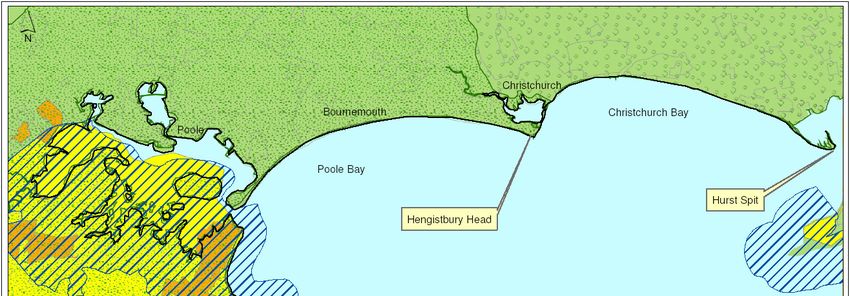
THIS PAGE LEFT
INTENTIONALLY
BLANK

Poole and Christchurch Bays SMP2   9T2052/R/301164/Exet
Report V3                                         2010
26 Beatrice Road
                                                            Bodmin
                                                            Cornwall PL31 1RD
                                                            United Kingdom
                                                            +44 (0)0208 75947                      Telephone
                                                                                                   Fax
                                                            info@peterborough.royalhaskoning.com   E-mail
                                                            www.royalhaskoning.com                 Internet

Document title                    POOLE & CHRISTCHURCH BAYS SMP2
                                  Sub-cell 5f
                                  Appendix D
                                  Natural and Built Environment Baseline
                                  (Thematic Studies)
Document short title              Theme Review
Status                            Final Report
Date                              October 2010
Project name                      Poole & Christchurch Bays SMP2
Project number                    9T2052
Client                            Bournemouth Borough Council
Reference                         Bodmin/303478

                    Drafted by    D Miles / J Ridgewell

                  Checked by      T Eggiman / P Brunner
           Date/initials check    ………………….            ………………….
                 Approved by      H Hall
         Date/initials approval   ………………….            ………………….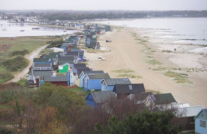
THIS PAGE LEFT
INTENTIONALLY
BLANK

Poole and Christchurch Bays SMP2   9T2052/R/301164/Exet
Report V3                                         2010
Contents:
1 Introduction...........................................................................................i
2 Current and Future Land Use ............................................................ 2
2.1 Overview 3
2.2 Shoreline Management Plan Population Dynamics 13
2.3 Future planning targets 13
3 Natural Environment ........................................................................ 16
3.1 Landscape and natural character assessment overview 16
3.2 Designated area assessment 25
3.3 Assessment of the Natural Environment 28
3.4 Conservation targets and plans 37
4 Historic Environment ........................................................................ 39
4.1 Assessment of the Historic Environment 39
List of Figures:
Figure 2.1 Overview Map .................................................................................... 4
Figure 2.2 Aerial view of Hurst Castle ................................................................. 6
Figure 2.3 Mudeford Sandbank Beach Huts ....................................................... 7
Figure 2.4 Refurbished Boscombe Pier .............................................................. 8
Figure 2.5 Bournemouth beach........................................................................... 9
Figure 2.6 Aerial view of Poole Quays .............................................................. 10
Figure 2.7 Branksea Castle Jetty ...................................................................... 10
Figure 2.8 Wareham Quay ................................................................................ 11
Figure 2.9 Old Harry Rocks (Handfast Point).................................................... 12
Figure 2.10 Swanage Beach ............................................................................... 12
Figure 3.1 Key landscapes of the Poole and Christchurch Bays SMP2........... 17
Figure 3.2 The Natterjack Toad......................................................................... 20
Figure 3.3 Dartford Warbler............................................................................... 22
Figure 3.4 Durlston Bay..................................................................................... 24
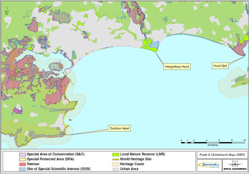
Figure 3.5 Overview of Designations in the SMP area ..................................... 26
Figure 4.1 Historic Sites and Scheduled Monument Locations ........................ 40
Figure 4.2 Valentine Tank ................................................................................. 45
Figure 4.3 Poole Log Boat................................................................................. 48
List of Tables:
Table 2.1 Populations statistics (census-based data)........................................... 13
Table 2.2 Population projections for Bournemouth, Poole and Christchurch ....... 14
Table 3.1 Designated Conservation Areas for Sub-cell 5F- 1............................... 29
Table 3.2 Designated Conservation Areas for Sub-cell 5F- 2............................... 30
Table 3.3 Designated Conservation Areas for Sub-cell 5F- 3............................... 31
Table 3.4 Designated Conservation Areas for Sub-cell 5F- 4............................... 32
Table 3.5 Designated Conservation Areas for Sub-cell 5F- 5............................... 35
Table 4.1 Scheduled Monuments of relevance to the SMP (Sub-cell 5F-I) .......... 41
Table 4.2 Scheduled Monuments of relevance to the SMP (Area 5F-2) .............. 42
Table 4.3 Scheduled Monuments of relevance to the SMP (Sub-cell 5F-3) ......... 44
Table 4.4 Scheduled Monuments of relevance to the SMP (Sub-cell 5F- 4) ........ 47
Table 4.5 Scheduled Monuments of relevance to the SMP (Sub-area 5F-5) ....... 49
Table 4.6 Scheduled Monuments of relevance to the SMP (Sub-cell 5F-6) ......... 49
Poole and Christchurch Bays SMP2 9T2052/R/301164/Exet
Report V3 2010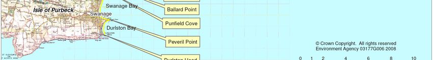
THIS PAGE LEFT
INTENTIONALLY
BLANK

Poole and Christchurch Bays SMP2   9T2052/R/301164/Exet
Report V3                                         2010
1       Introduction
This Appendix provides a thematic review that establishes the key features along the
coast and describes why these features collectively summarise the value of this area of
coast. The values identified relate to the natural features of the coast, the landscape
and character of the area and the historic structures and spatial features that define the
overall character of this section of coast. It describes what make Poole and
Christchurch Bays unlike any other section of the English coastline.

                   Thematic Basis of Options Development
                                              Options
                   Natural                                    Options
                                          Development
                   Environment                              Evaluation
                   Landscape

                   Historic
                   Environment

                   Future
                   Land Use

The description of the coast in this way provides the foundation for shoreline
management that accounts for the particular character of the area. It provides an
understanding of the key elements that shape the unique character of this stretch of
coast. Additionally, the likely future land use patterns in the study area have been
reviewed based on a consideration of the relevant strategic and land use plans. The
provision of this information underpins the development of policy options for the coast
and informs a considered approach to options evaluation.

There are no conclusions drawn from this descriptive report. Its aim is to familiarise the
reader with the diverse human, natural and historic environment of the Poole and
Christchurch Bays. Separate reports cover coastal processes, structures and the
Strategic Environmental Assessment.

Poole and Christchurch Bays SMP2         Appendix D                    9T2052/R/301164/Exet
Report V3                                   D-1                                       2010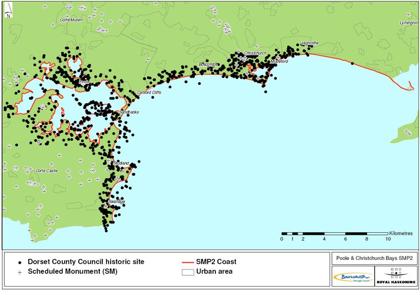
2       Current and Future Land Use
This section provides an account of the urban environment in terms of existing land uses
and patterns of development. The relevant regional strategies and local land use plans
have been used as a structured basis for this description. With the introduction of
Regional Spatial Strategies and Local Development Frameworks, the planning system is
currently undergoing reformation and the majority of land use plans are either under
review or to be replaced. The study area has been broken down by local authority
boundary with an initial description offered from a regional perspective. Given that the
use of land is determined by the statutory planning process, statutory plans have been
the main focus of this study.

The regional plans that have formed the basis of this assessment are:

    •   Regional Planning Guidance for the South West - RPG 10
    •   Regional Planning Guidance for the South East – RPG 9

On a national level, Planning Policy Statement 9 (PPS9) on Biodiversity and Geological
Conservation (2005) establishes the Government’s policies on the protection of
biodiversity and geological conservation through the planning system. Although not
aimed at Shoreline Management Plans (SMP) in particular, the key focus within PPS 9
is that development (or for example SMP policy) should not harm biodiversity and
geological conservation interests, unless there is sufficient reasoning (or benefits) that
outweigh the impact.

At county level, the Bournemouth, Dorset and Poole Structure Plan (CSP28) provide
current policy.

Local planning policy has been related to the following:

Borough of Poole (BoP)
   • Regional Spatial Strategy (2006)
   • Poole Local Development Scheme (2007)
   • Bournemouth, Christchurch, East and North Dorset and Salisbury SFRA (2008)
    •   Bournemouth, Dorset and Poole Structure Plan (2000)
    •   Poole SFRA levels 1 and 2 (2008)

Bournemouth Borough Council (BBC)
   • Regional Spatial Strategy (2006)
   • Bournemouth, Dorset and Poole Structure Plan (2000)
   • Bournemouth Local Development Scheme (2007)

Christchurch Borough Council (CBC)
   • Regional Planning Guidance for the South West (2001)
   • The Draft Regional Spatial Strategy for the South West 2006 – 2026 (2006)
   • Borough to Christchurch Local Plan (2001)
   • Christchurch Community Plan (2004)

Poole and Christchurch Bays SMP2         Appendix D                    9T2052/R/301164/Exet
Report V3                                   D-2                                       2010
• Christchurch and East Dorset Core Strategy (2008)
• Christchurch Beaches and Hinterland Management Plan 2008 – 2018 (2007)
New Forest District Council
• New Forest District Local Plan Part B (2005)
• New Forest District Local Plan (2005)
• New Forest District Council Local Development Framework: Core Strategy
(2008)
• New Forest Corporate Plan 2008 - 2012 (2007)
Purbeck District Council
• Purbeck District Local Development Scheme (2007)
• Regional Development Strategy (2008)
• Purbeck District Local Plan (2011)
• A Sustainable Future for Purbeck (2001)
• Community Plan for Purbeck 2006 – 2009 (2005)
Compared to the cohesive management arrangement applied to the land, management
of the marine environment has been disjointed. To improve this situation, a Draft Marine
Bill was published in 2008. The Marine Bill aims to:
• create a strategic system of marine spatial planning,
• streamline and simplify licensing of particular activities at sea,
• revise measures for inshore fisheries management, and
• consider the need for a new maritime management organization.
In addition to the Marine Bill, the Water Framework Directive (WFD) has been
introduced to improve and integrate the way water bodies, including coastal waters, are
managed throughout Europe. The WFD is designed to:
• enhance the status and prevent further deterioration of aquatic ecosystems and
associated wetlands, which depend on the aquatic ecosystems,
• promote the sustainable use of water,
• reduce pollution of water, especially by ‘priority’ and ‘priority hazardous’
substances, and
• ensure progressive reduction of groundwater pollution.
In the UK, much of the WFD implementation work will be undertaken by competent
authorities. It came into force in December 2000, and was put into UK law in 2003.
Under this framework, Member States must aim to reach good chemical and ecological
status in inland and coastal waters by 2015 (from Defra website).
It is anticipated that these two legislative items will encourage a more cohesive
management of the marine environment in the future.
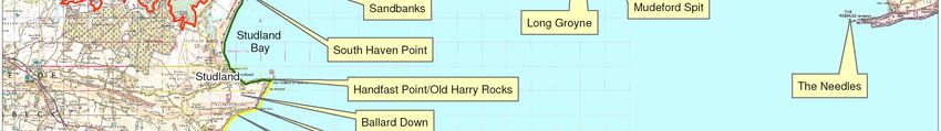
2.1 Overview
This section presents an overview of the coastline from Hurst Spit to Durlston Head.
The coast is divided into sub-cells, and these are described in turn. The sub-cells and
key features are shown in Figure 2.1.
Poole and Christchurch Bays SMP2 Appendix D 9T2052/R/301164/Exet
Report V3 D-3 2010Figure 2.1 Overview Map Poole and Christchurch Bays SMP2 Appendix D 9T2052/R/301164/Exet Report V3 D-4 2010
The main urban areas along the Shoreline Management Plan (SMP) coastline are
Bournemouth, Christchurch and Poole. Smaller towns include Swanage, Wareham,
Milford-on-Sea and Barton on Sea. There is considerable pressure for new residential
development along the coast, owing, in part, to the substantial inflow of retired people to
the region, and the continued demand for premium waterfront properties, particularly
when associated with leisure facilities.

Sub-cell 5F-1 Hurst Spit to Hengistbury Head

This sub-cell covers all of Christchurch Bay. It is relatively undeveloped along the
eastern coastline, with development increasing towards the west with Milford-on-Sea,
Barton on Sea and the suburbs of Christchurch. This area consists mainly of residential
properties, with tourism and service industries providing the main commercial and
industrial activity. These settlements generally have an older than average population,
with many people choosing to retire here.

The whole of this coast is accessible to the public with car parks and amenities at
Milford-on-Sea, Barton on Sea and Taddiford Gap. The bathing water in the bay meets
EC quality standards, and water-based sports such as swimming, sailing and fishing are
popular (Milford-on-Sea Parish Council 2007). Sections of the cliffs along this section of
the coast are constantly eroding and have resulted in considerable coast protection and
management works in specific locations.

At the end of Hurst Spit is Hurst
Castle (Figure 2.2), built for Henry
VIII in the 1540s and currently
under the stewardship of English
Heritage (Milford-on-Sea Parish
Council 2007). Access to Hurst
Spit is by foot or boat, and it is a
popular tourist destination.

                                        Figure 2.2        Aerial view of Hurst Castle
                                          (Image courtesy of Channel Coast Observatory)

Milford-on-Sea originated in the centre of an agricultural parish, when the coastline was
further south than it is now. The village expanded rapidly over the past 100 years, and
is currently experiencing extensive redevelopment at the western end of the cliff. The
area has a considerable amount of open space such as Hordle, Hurst Spit, Sturt Pond
and Rook Cliff, as well as Studland Common, local sports grounds and golf courses.

Barton on Sea and Highcliffe are separated from Milford-on-Sea by an extensive clifftop
golf course. The two towns mainly comprise of residential developments. These
developments lie along the A337, the main east-west link road between Christchurch
and Lymington. The county boundary between New Forest District Council and
Christchurch Borough Council lies between Highcliffe and Barton on Sea, along a
natural feature called Chewton Bunny. The beaches here are also popular with beach
huts along the front and good facilities for visitors.
Poole and Christchurch Bays SMP2         Appendix D                          9T2052/R/301164/Exet
Report V3                                    D-6                                            2010
Sub cell 5F-2 Christchurch Harbour
Christchurch Harbour is a popular tourist destination, with the town of Christchurch
(situated to the north and east of the Harbour) providing tourist accommodation and
facilities. The Harbour has well-developed boating, windsurfing and fishing facilities,
with Mudeford Quay the centre of the local sea fishing industry.
Christchurch is a residential and tourist town with a strong retirement population
(approximately 34% of the population are over 65). This older population supports the
local economy year round (services and retail), in addition to the tourism/holiday
facilities in the summer.
The western side of Christchurch Harbour consists of marshland and is undeveloped.
This area is popular with bird enthusiasts and retains its natural condition. The south
western corner is dominated by a golf course and driving range. The communities of
Mudeford and Mudeford Quay are located on the eastern spit of the entrance to
Christchurch Harbour and comprises a quay, car park, boat park and offices. The quay
is a popular destination, and ferries depart for points around the harbour and to
Mudeford Sandbank. Approximately 130 static holiday caravans are situated at
Sandhills behind Mudeford Quay and adjoining the coast.
The western sandspit is known as Mudeford Sandbank, a community of highly valued
beach huts, a café and facilities. The sandspit is protected by rock groyne defences
(Figure 2.3).
Figure 2.3 Mudeford Sandbank Beach Huts
Poole and Christchurch Bays SMP2 Appendix D 9T2052/R/301164/Exet
Report V3 D-7 2010Sub cell 5F-3 Hengistbury Head to Sandbanks Slipway
Hengistbury Head lies at the eastern extremity of this sub-cell. This undefended natural
high point and landmark is a very popular walking and recreational spot, with a large
visitors car park. The area is used year round by local residents and visitors. Access is
possible to Mudeford Spit from here, and also to quiet beaches in front of the
Hengistbury Head cliffs.
The frontage is highly developed west of Hengistbury Head, and is protected by a
combination of rock and wooden groynes from Double Dykes westwards. The coast
from Double Dykes to Hengistbury Long Groyne is undefended. This frontage includes
Bournemouth and its suburbs Southbourne, Boscombe and Westbourne. The boundary
between Bournemouth Borough Council (BBC) and Borough of Poole (BoP) lies at the
eastward side of Branksome Chine, with Canford Cliffs and Sandbanks lying in the
Borough of Poole. It is important to note that most of the Bournemouth frontage is
privately owned with BBC as a lessee.
Bournemouth is a very popular recreational and tourist area that attracts 5.2 million
visitors a year to its 8km (5 miles) of beach, promenade, and piers (Seafront Strategy
Study 2006). The beach is considered Bournemouth’s greatest asset, and a beach
recharge programme ensures there is a healthy beach, providing amenity and coast
protection.
BBC maintains 31 public buildings, over 500 seafront chalets, piers at Bournemouth and
Boscombe (Figure 2.4), and a range of
stores, depots and offices along the
frontage. Additionally there are three cliff
lifts (funicular railways) that enable access
to the beach in addition to the numerous
paths and steps. To minimise beach
disruption any maintenance or
improvements to the frontage is carried out
in the winter months (BBC 2006).
F
Figure 2.4 Boscombe Pier
The frontage is very popular year round for recreational activities such as cycling,
walking, running, fishing, bathing, surfing, personal watercraft use and paragliding. The
piers are open year round and are frequently used for fishing.
Seasonal local cruises on the paddle steamers Waverley and Balmoral operate from
Bournemouth Pier, as do regular trips by the Dorset Belles and the Shockwave
speedboat (PHSG, 2006). Bournemouth is also preparing for an anticipated increase in
visitors due to the 2012 Olympics sailing activities to be based in nearby Weymouth.
Bournemouth also hosts a range of regionally important events, such as fireworks
shows, carnivals, live music festivals, boat races, car rallies and air shows. These
events have and require good management and facilities due to their popularity (Figure
2.5).
Poole and Christchurch Bays SMP2 Appendix D 9T2052/R/301164/Exet
Report V3 D-8 2010Figure 2.5 Bournemouth beach
Photograph: Corbis
Crossing the boundary between BBC and BoP at Branksome Chine, there is no
significant change in character of the beachfront, consisting of sandy beaches, wide
promenade and seafront amenities. The Poole communities of Branksome and Canford
Cliffs lie above the cliff which is punctuated with Branksome Dene Chine and Flag Head
Chine.
The residential settlements that lie along the shoreline, particularly the community of
Sandbanks, currently represent some of the most expensive properties in the area.
Local government has demonstrated the need for affordable housing facilities in the
area. However, the amount of undeveloped land in the Borough is limited, particularly
within coastal areas, thus demand for residential flats to be re-developed has grown. As
a result of this a number of proposed ' flat character areas'have been designated for the
development of residential flats.
This stretch of coastline is well defended with seawalls and groynes. Rock groynes
have recently been installed along the Sandbanks peninsular, and large car parks cater
for the high numbers of visitors in the summer.
Sub-cell 5F-4 Poole Harbour
Poole Harbour is heavily developed along its northern side, with the borough of Poole
between North Haven Point and Rockley Point. There is very little development on its
eastern, and southern sides with the exception of Wareham. Poole is the most
commercially active area in the unit, and properties along the waterfront are mostly
commercial with limited high valued residential properties (i.e. Sandbanks community).
A car and passenger ferry links the Sandbanks peninsula to the Studland peninsula.
There are residential waterfront communities at Lilliput, Parkstone and Hamworthy, with
a large static caravan site at Rockley Sands. A railway links these communities with
Bournemouth and Wareham, crossing Parkstone Bay, Holes Bay and Lytchett Bay by
means of viaducts. The A35 trunk road also links Bournemouth and Poole. Hamworthy
Quays and Old Town (with access to the port and industry) are connected by Poole
Bridge, which is a lifting bridge and is often congested with traffic.
Poole and Christchurch Bays SMP2 Appendix D 9T2052/R/301164/Exet
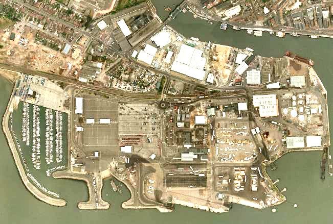
Report V3 D-9 2010Poole Quays (Figure 2.6) is a busy
commercial port facilitating cargo carrying
vessels as well as cross-channel ferries,
handling over 400,000 tonnes of cargo,
over 70,000 units of roll-on/roll off freight
traffic and around 700,000 ferry passengers
per year. The ferry terminal has two Ro/Ro
berths and covers 18 hectares (44 acres).
Figure 2.6 Aerial view of Poole Quays
(Image courtesy Channel Coast Observatory)
To maintain access for these larger vessels, the Harbour channels are dredged. Some
of the dredged sediment has been used to maintain beach levels in Bournemouth, Poole
and Swanage.
The area is a popular base for tourists and visitors, offering plenty of facilities. Poole
Harbour is a shallow and well-protected with an extended period of high water, making it
ideal for inshore water activities such as windsurfing, kite surfing, wakeboarding, water
skiing, dinghy sailing and canoeing.
Poole Harbour is under the authority of Poole Harbour Commissioners, a non-profit
making trust, who control any development extending below Mean High Water such as
jetties and marinas, as well as maritime traffic in the Harbour. Existing alongside these
large-scale commercial activities is an important local commercial fishing community,
with approximately 100 boats based in the port, and areas of the seabed used for the
cultivation of shellfish.
There is a significant area of light industry at Hamworthy & Holes Bay. One of the
largest private sector employers in the county are Sunseeker, who construct luxury craft
at their factories on the south side of Little Channel. There are also a number of yacht
clubs, several thousand moorings and a Ministry of Defence (MoD) base along the
northern side of the Harbour (PHSG, 2006). The Royal National Lifeboat Institution
(RNLI) has its headquarters based in Poole, along with a training college. Private boat
use is a major economic driver in Poole, with many small industries engaged in retail,
maintenance and construction of small vessels.
There are a number of low-lying islands in the harbour, the largest of which is Brownsea
Island. The island is owned by the
National Trust, with Branksea Castle
(Figure 2.7) on the eastern side of the
island leased to a private company, and
approximately 40% of the island leased to
Dorset Wildlife Trust. The island does
support a small local population, and
some accommodation is available for
visitors. Brownsea is a major attraction
for bird watchers and nature
Figure 2.7 Branksea Castle Jetty
Poole and Christchurch Bays SMP2 Appendix D 9T2052/R/301164/Exet
Report V3 D-10 2010enthusiasts and supports a small but stable population of red squirrel. It is accessible to
visitors by ferry from Sandbanks, Poole Quay and Swanage.
The second-largest island in the harbour is Furzey Island, containing Wytch Farm oil
field, owned by BP and consisting of three separate oil reservoirs under Poole Harbour
and Poole Bay. Drilling extends to 10km offshore to a depth of 1640m. This is the UK’s
largest inshore oil field, and this facility produces an average of 23,000 barrels of oil and
50 tonnes of Liquefied Petroleum Gas (LPG) per day. The original estimated capacity of
the oil field when discovered in 1959 was 480million barrels (BP 2009). Other oil wells
are located on Goathorn, Ower and Fitzworth Points.
Wareham (Figure 2.8) is situated at
the western end of Poole Harbour,
between the mouths of the Rivers
Piddle and Frome. The historic part of
the town is compact, and further
development in the town is
constrained by river valleys and the
original Saxon earth ramparts that
surround the town.
Figure 2.8 Wareham Quay
Sub cell 5F-5 South Haven Point to Handfast Point
Studland Bay lies to the south of Poole Harbour entrance, from South Haven Point to
Handfast Point. It is primarily a long sandy beach, backed by dunes and heathland with
limited development along its coastline. The heathland is a nature reserve owned and
managed by the National Trust and designated under European & International
directives & conventions.
South Haven Point at the northern end of the peninsular has the slipway for the
Sandbanks ferry. A sculpture at South Haven Point marks the start or the end of the
South West Coastal Footpath. This is the longest National Trail in the UK, and follows
the coast from Poole Harbour to Minehead in Somerset.
Shell Bay is located at the northern end of the bay, with the small village of Studland
located at the southern end of the Bay. The village of Studland consists of a small
community of houses and shops (some of which cater for tourists), community open
space, bed and breakfasts, a large hotel, village pubs and community buildings. Despite
the influence of tourism at Studland, the village has managed to retain its local charm
and character.
Studland Bay receives up to 1.5 million visitors a year, attracted by the sandy beaches
and a range of beach and water-based activities. Visitors use the chain ferry from
Sandbanks to South Haven Point for access, as it is a considerable drive around Poole
Harbour.
Poole and Christchurch Bays SMP2 Appendix D 9T2052/R/301164/Exet
Report V3 D-11 20105F-6 Handfast Point to Durlston Head
There are two bays in this sub-cell: Swanage Bay and Durlston Bay, separated by
Peveril Point. To the north of Swanage Bay is Ballard Point and Ballard Down, owned
and managed by the National Trust. Further north is Handfast Point (also known as The
Foreland), which is the remnants of a chalk ridge that once extended to the Isle of
Wight, indicated by the landmarks of Old Harry Rocks (Figure 2.9).
Figure 2.9 Old Harry Rocks (Handfast Point)
To the south of the bay lies the town of Swanage, a small town with some commercial
activity based on local retail and fishing industries. The town sits behind both Swanage
and Durlston Bays, and has a promenade along part of its frontage and a recently
refurbished pier.
Swanage is popular for boating, fishing, diving and climbing, and the area draws a
reasonable number of visitors. Swanage Bay is a long sandy beach (Figure 2.10)
defended with wooden groynes and
beach recharge. Houses and
hotels are situated on or close to
the cliff top. Some parts of the cliff
are eroding and slumping in places,
and various cliff stabilisation
measures have been undertaken in
front of individual properties.
Further north towards Ballard Point
the beach is undeveloped and
consists of beaches, cliffs and
dunes. There are a number of huts
along the beach.
Figure 2.10 Swanage Beach
Durlston Bay has a small amount of development protected by a revetment in the centre
of the bay and is undeveloped towards the north and south. At the southern most point
of Durlston Bay is Durlston Castle, built in 1886 of local stone. The castle is currently
being renovated to house the Jurassic Coast Visitor Centre. Durlston Country Park
covers 113 hectares and is owned and managed by Dorset County Council.
Poole and Christchurch Bays SMP2 Appendix D 9T2052/R/301164/Exet
Report V3 D-12 20102.2 Shoreline Management Plan Population Dynamics
The resident population of the County of Hampshire in 1991, excluding Portsmouth and
Southampton was 1,169,986; by 2001 this had risen to 1,240,103. This represents an
increase of over 6%, compared to an increase of 4% from 1981 to 1991. This is an
average population for a non-metropolitan county in England and is similar to the other
coastal counties of East and West Sussex.
In the County of Dorset as a whole, including Bournemouth and Poole, the population
increased from 645,200 in 1991 to 692,700 in 2001, an increase of 6.8%. During the
same period, the population of Purbeck increased by 4.6%, from 42,445 to 44,416. In
contrast, the population of England and Wales grew by only 0.12% between 1981 and
1991, suggesting that population increases in the SMP area are caused by in-migration
from other parts of the country.
Population statistics showing changes in population in the main settlements of Milford-
on-Sea, Christchurch, Bournemouth, Poole, Wareham and Swanage are shown in Table
2.1. These figures are based on the 1991 and 2001 census, which measures population
on the day of the census.
Table 2.1 Populations statistics (census-based data)
Total Population Total Population
Town Increase (%)
(2001) (1991)
Milford-on-Sea 4,703 4,434 5.7
Christchurch 44,869 41,123 8.3
Bournemouth 163,441 151,302 7.4
Poole 138,299 133,055 3.8
Wareham 5,620 5,680not take into account any future policy changes or local development policies that have
not yet occurred. The latest sets are the 2006-Based Sub-National Projections and are
constrained to the 2006 Mid-Year Population Estimates. A summary of these
projections is shown in Table 2.2.
Table 2.2 Population projections for Bournemouth, Poole and Christchurch
Year
Town
2006 2011 2016 2021 2026 2031
Bournemouth 161,200 161,600 162,400 164,200 167,000 170,600
Poole 136,900 137,000 138,100 140,200 142,700 145,100
Christchurch 45,000 45,500 46,300 47,500 48,800 50,100
Source: 2006-Based Sub-national Population Projections, ONS, Crown Copyright
These population projections estimate a 3% increase for Christchurch and• More efficient use of land and buildings within the urban areas through
conversion, redevelopment and increased residential building densities, and
• Continued development of the Port of Poole and Bournemouth International
Airport, including improvement of regional and local transport links.
Objectives for the coast are identified as:
• Regenerate coastal towns and communities, reinforcing their economic and
social roles, and
• Conserve the environment of the coast and coastal waters, protecting
undeveloped coast from inappropriate development.
RPG 10 proposes that outside of the PUAs future development should generally avoid
significant growth in the larger towns, such as Swanage and Christchurch, which are
within easy commuting distance of a PUA, in this case Bournemouth and Poole. It is
recommended that housing development should not proceed out of step with
employment.
There are continuing pressures for leisure, recreation, tourism and housing
developments on the undeveloped sections of coastline. Future policies should aim to
keep these areas substantially undeveloped, provided that the legitimate development
needs of such areas can be met within the nearby urban areas or in less sensitive
locations away from the coast.
In summary, Bournemouth and Poole are expected to increase in density through
redevelopment, while smaller towns such as Swanage, Wareham, and Christchurch will
experience a small increase in size, depending on the economic climate. The
undeveloped parts of the coast are expected to remain undeveloped. Transport links
are expected to improve, particularly near the ports and airports.
Poole and Christchurch Bays SMP2 Appendix D 9T2052/R/301164/Exet
Report V3 D-15 20103 Natural Environment
The provision of shoreline management policies fundamentally seeks to provide the
most practical, sustainable and equitable approach to protecting the environmental,
social and economic values of the coastal zone. The environmental values have
therefore been described as Nature Conservation, which encompasses all the
designated areas within the study area and also the sites and features, which are
important from an earth heritage perspective. The description of these two facets of the
natural environment is entirely consistent with management of such areas by Natural
England.
Earth heritage sites are also often important in their own right (for example exposures of
fossil beds or type exposures) but equally in that they are intrinsically linked to natural
processes, which critically underpin the maintenance of ecological values in the coastal
zone. The natural environment within the coastal zone encompassing the area either
side of the shoreline management line covered in this SMP includes terrestrial, intertidal
and marine habitats and geology. Within the study area a wide diversity of sites and
features are found which reflects the area’s physical diversity and co-evolutionary past
where human activity has shaped the landscape and local ecology.
3.1 Landscape and natural character assessment overview
Landscape character is an important national resource that is part of our natural and
cultural inheritance, widely appreciated for its aesthetic beauty, contribution to regional
identity and sense of place. The recognition of coastal landscape values is therefore
critical to the choice of coastal defence options, since the consequences of such actions
have the potential to radically change the coastal landscape.
Landscape Character Assessment (LCA) is an approach to understanding the
differences between landscapes, and can serve as a framework for decision-making that
respects local distinctiveness. It is a way of '
unpacking'the landscape and
understanding how its distinctive elements contribute to sense of place. As such, LCA is
a useful tool for engaging stakeholders in sustainable development. Communities,
developers, farmers and land managers, landscape and planning professionals and
others all have a role in identifying the characteristics that make a particular landscape
unique, and using this understanding to plan and manage landscape change.
This section therefore reviews the identified coastal landscape features for the study
area as they have been identified by means of local study or designation.
Key landscape features in this SMP are shown in Figure 3.1.
Poole and Christchurch Bays SMP2 Appendix D 9T2052/R/301164/Exet
Report V3 D-16 2010Figure 3.1 Key landscapes of the Poole and Christchurch Bays SMP2 Each sub-cell is described in terms of three spheres of environment: • landscape environment • coastal environment • marine environment Landscape environment discusses the inland nature of the coast, coastal environment describes the beach and intertidal nature of the coast, and marine environment describes the sub-tidal and offshore environments. Sub-cell 5F-1 Hurst Spit to Hengistbury Head Long Groyne Landscape Environment Hurst Spit consists of a narrow shingle embankment extending approximately 2.5km seawards with a castle and lighthouse at its eastern tip. There is open sea to the south and saltmarsh creeks to the north. This is an area with a special sense of remoteness, being accessible only by foot or boat, and is of great natural beauty, which is accentuated by its sense of history. The coastline here is generally open and exposed, producing characteristic windswept forms of growth. Key features are the soft eroding cliffs, shingle beaches and small wooded areas. There are large areas of public open space and car parks along the cliff tops which are well used by local residents and visitors. Poole and Christchurch Bays SMP2 Appendix D 9T2052/R/301164/Exet Report V3 D-17 2010
Milford-on-Sea to Highcliffe consists of low-lying slumped cliffs behind a sand and
shingle beach. The cliffs between Highcliffe and Milford-on-Sea have not been
designated as being of international geological importance. However they are
considered to be of national importance due to stratigraphic, structural and fossil flora
and fauna for the Tertiary to Palaeolithic geological periods. Important sites include:

    •   The cliffs between Highcliffe and Barton on Sea
    •   The coast from Friars Cliff to Milford-on-Sea
    •   Hordle Cliff

Between Highcliffe and Mudeford Quay there is a narrow sand and shingle beach
protected from erosion by timber groynes, rock groynes, and concrete seawalls with
areas of shingle recharge. Despite these defence works, erosion is still ongoing which
allows access to the fossil rich Barton and Headon Beds, particularly from Friars Cliff to
Milford-on-Sea.

Chewton Bunny is the only site to yield fossil plants from the Lower Barton Beds, whilst
the Barton Cliffs are important for early Tertiary reptiles, particularly turtles. Paddy'
                                                                                        s
Gap is a famous fossil plant locality with abundant fossil fruit remains. Hordle Cliff is a
key site for fossil birds, mammals, reptiles and plants. There are seven genera of fossil
plants found only at this site in Britain. Associations of plant fossil with faunal remains
make this a valuable site for palaeoenvironmental analysis. This is a critical site for
European Tertiary palaeobotany and palaeoecology.

Coastal Environment
The beach at Hurst Spit is mainly composed of shingle, which supports little vegetation.
However, the shingle ridges at Hurst Spit support an important flora that is dependent on
the substrate. Intertidal mudflats, cord-grass marshes and level mixed saltmarsh occur
to the north of Hurst Spit and around Sowley Pond. These areas support large breeding
and over-wintering populations of wildfowl and other birds.

The coastal cliffs are vegetated in places and form a habitat-type associated with soft
cliffs. This includes species such as willow, reeds, reedmace and coltsfoot. In other
areas the cliffs are actively eroding and are devoid of vegetation. The vegetated and
open cliffs provide habitats for a range of invertebrates.

Marine Environment
Offshore to the south of Hurst Spit is the deepest area of the Solent reaching 60m in
depth, and encompassing a diverse range of habitats and communities. The subtidal
marine life represents a transition between the warm temperate (Lusitanian) and cold
temperate (Boreal) marine biogeographic provinces, resulting in a rich variety of
organisms including representatives of both provinces. The seabed is composed of
sandy sediment, which supports a variety of organisms including the dominant slipper
limpet, which is an alien species, and burrowing worms and molluscs. The coastal
marine environment acts as a spawning and nursery area for several species of
commercially important fish including Dover sole, cod, and bass.

An ironstone reef stretches 5km east of Hengistbury Head out into Christchurch Bay,
forming the Christchurch Ledges. The Ledges provide a solid substrate in an area
dominated by mobile sandy sediments, which support diverse assemblages of kelp and
other algae, along with a variety of animals including nationally rare fish, bryozoans,
sponges and anemones.
Poole and Christchurch Bays SMP2         Appendix D                     9T2052/R/301164/Exet
Report V3                                   D-18                                       2010
5F- 2 Christchurch Harbour Landscape Environment Christchurch Harbour is a natural harbour sheltered to the south from the higher ground of Hengistbury Head. The estuary, surrounding marshes, heath and woodland present a natural landscape creating a distinct character considered attractive. The Rivers Stour and Avon drain into Christchurch Harbour, and their alluvial deposits have created a flat flood plain to the west of the Harbour. The town of Christchurch lies adjacent to the Harbour on the west and north side. The area is not covered by any national landscape designations, although the local authorities recognise the beauty of the area and seek to protect it through local policies. There are no sites of high geological or geomorphological interest in Christchurch Harbour. Coastal Environment Christchurch Harbour contains a wide range of habitats including shallow mudflats, saltmarsh, reed beds, ditches, wet meadows, sand dunes, dry and neutral grassland, heath, woodland and scrub. These habitats support diverse plant and animal communities, and the site is of ornithological importance. Marine Environment The Harbour' s narrow entrance reduces the level of flushing, and creates an internationally rare habitat of brackish lagoon conditions. Whilst few species are represented, there are large populations of intertidal and subtidal marine invertebrates. Extensive areas of shallow intertidal mudflats support dense populations of burrowing organisms, which provide an important food source for the internationally important and designated bird life that frequents the Harbour. Rare brackish water species include nationally rare amphipods and the tentacled lagoon worm. The Harbour also acts as an important nursery ground for several commercial species of fish, including bass, Dover sole, thick-lipped mullet, thin lipped mullet, pollack and flounder. The estuaries that form the harbour are important salmon and eel fisheries and recreational angling occurs throughout the year. Sub-cell 5F-3 Hengistbury Head Long Groyne to Sandbanks Ferry Slipway Landscape Environment Hengistbury Head is a dramatic promontory forming the eastern most point of Poole Bay, and the southern flank of Christchurch Harbour. The two-mile long headland consists of a partly wooded ridge, with mudflats on the north sides within Christchurch Harbour, and a sandy/shingly beach to the south. Within a small area there is a mixture of heath, woodland, meadow, saltmarsh, dune and a shingle and rocky shore. The cliffs of Hengistbury Head undergo constant erosion. They have alternating deposits of Tertiary sands, loams and clays, capped at different levels with Pleistocene river gravels and alluvium (Hengistbury Head Management Plan, 1988). Hengistbury Head is a strategically important bridging exposure, and is included within the boundaries of the Christchurch Harbour SSSI for its geology features. From Hengistbury Head, the cliffs rise and are more developed, with a promenade along the frontage from Bournemouth to Poole. Poole and Christchurch Bays SMP2 Appendix D 9T2052/R/301164/Exet Report V3 D-19 2010
In 1991 BP undertook a Landscape Assessment of the Poole Bay conurbation. This
divided the coast into the following character zones:
    • Southbourne. Buildings are set back from the cliff top and consist mainly of
        Edwardian and 1930s detached properties. The cliffs are gently sloping and are
        vegetated with heath and grass.
    • Boscombe has a denser provision of large properties in the coastal zone, mainly
        hotels or high-rise apartment blocks.
    • Bournemouth. The western cliffs show sections of the Bournemouth Freshwater
        Beds. The beds have also yielded a diverse fossil flora of the mid-Eocene age.
        The eastern cliffs show unique exposures of the Bournemouth Marine Beds and
        of the Boscombe Sands. These formations display probably the best examples
        of meso-tidal estuarine sedimentation in the British Eocene. The eastern cliffs
        contain freshwater geology that is visible for study.
    • Canford Cliffs is characterised by steep sandstone cliffs, cut in places by chines
        (steep-sided river valleys). Some of the chines have public gardens and provide
        access to the beach. Cliff top development consists of large detached suburban
        houses, converted into flats, on pine-clad slopes. This area contains important
        heathland habitats, which although not fully developed in some areas, currently
        supports good reptile populations of sand lizards.
    • Sandbanks is a natural spit that extends across the mouth of Poole Harbour
        from the north. It has been extensively developed for housing and tourism, with
        the resultant loss of most of the original sand dunes, though some have
        regenerated.

Poole Bay frontage is of considerable geological interest. The discontinuous cliffs,
composed of Branksome Sand topped with fluvio-glacial gravels, extend along the
majority of the Poole Bay frontage. Erosion of these cliffs has historically contributed
large quantities of sediment into the littoral zone.

Coastal Environment
Hengistbury Head, along with Christchurch Harbour, is an area of outstanding interest to
bird life. The headland is a natural point
of arrival and departure for migrating
birds. The area also has a wide range of
habitats in a small area including recently
formed sand dunes west of Hengistbury
Long Groyne, and lowland grass, scrub
and woodland, which occupies most of the
headland. The grassland includes scarce
and rare species of flora and the rare
Natterjack toad (Figure 3.2) occurs over a
wide part of the area.
                                            Figure 3.2      The Natterjack Toad
                                                        (Image from Wildlifeforall.org)

Other habitats on the headland include ericaceous heathland, semi-natural woodland
and freshwater ponds. Hengistbury Head supports over 500 plant species, including the
nationally rare sea knotgrass (Schedule 8), 14 scarce species and 39 locally rare
species. More than 300 bird species have been recorded, as well as many insect and
reptile species, including the Natterjack toad. The cliffs beneath Warren Hill have a
regionally important colony of Sand Martins.

Poole and Christchurch Bays SMP2         Appendix D                         9T2052/R/301164/Exet
Report V3                                   D-20                                           2010
The cliffs along this coast undergo constant erosion, creating the unique landscape and habitats that have a significant value for nature conservation. The cliffs fronting Poole Bay provide a narrow strip of natural habitat between the town and the wide seafront promenade. Sections of the cliff are designated as SSSI for their geological features and support populations of the rare and declining sand lizard. There are also local seepage features, which provide a habitat for specialised invertebrate fauna. The sandy shores of Poole Bay are not of ecological interest, due to the presence of concrete seawalls and the high mobility of the sand along the coast, except for a residual area of sand dune at Sandbanks and Canford Cliffs, which has sand lizards. Marine Environment The gently shelving seabed presents all five major sediment types (mud, muddy sand, sand, muddy gravel and gravel) (EN 1994). The diversity of sediment types results in a varied marine benthic fauna (animals that live on the seabed). Burrowing bivalve molluscs are the dominant species present in the sediment with the alien slipper limpet dominating the surface of the seabed. Bournemouth Rocks make up the majority of hard substrate in the sub-cell, which supports a rich assemblage of algae and encrusting organisms. Poole Bay supports a number of commercial species including the rare native oyster. The population of native oysters is the largest in the UK and is possibly the largest in Northern Europe (JNCC 1996). Poole Bay also supports commercial fishing including cuttlefish, oysters, whelks, scallops, edible crabs, spider crabs and lobsters. Recreational angling from the beaches and from boats also occurs throughout the year. Sub-cell 5F- 4 Poole Harbour Landscape Environment Poole Harbour comprises of a wide expanse of water punctuated by wooded islands, creeks and mudflats with extensive modern development on its northern and eastern sides. Brownsea Island is within the Harbour, and is predominantly wooded, but has an enclosed man-made lagoon on its eastern side. Low-lying meadows flank the western margins of the Harbour and the southern shores are fringed with mudflats and marsh rising up to heathland and coniferous plantations. The sheltered waters and islands are a haven for wildlife, which forms a contrast to the bustling ferry port and the conurbation of Poole, which lies to the north. The onshore oil well at Furzey is screened from view by conifer plantations. Ham Common is an area of national geological importance and is designated a SSSI. This is one of two sites yielding fossil plants from the Dorset Pipe Clays of Lower Eocene age. Over seventy fossil species have been recorded here, of which thirty species and three genera are restricted to this site in British Tertiary floras, whilst many are unique in the World' s Tertiary deposits. The site is also the type locality for forty-four species and four genera of flora and is critical for studies of European Tertiary palaeobotany and palaeoecology. Brownsea Island and Shipstal Point at Arne are both designated as Regionally Important Geological Sites (RIGS) and the Arne exposure is a Geological Conservation Review Site (GCR). The cliffs on the southern side of Brownsea Island and a cliff near Pottery Poole and Christchurch Bays SMP2 Appendix D 9T2052/R/301164/Exet Report V3 D-21 2010
Pier show sections through the Branksome Sand and Parkstone Clay and the junction
between them. Shipstal Point, at Arne, consists of a cliff exposure demonstrating the
Poole Formation.

Coastal Environment
Poole Harbour is considered to be one of the best and largest examples of an enclosed,
lagoonal harbour in the UK. The harbour has an average depth of 2m, and contains a
high proportion of intertidal salt marshes and mudflats, which give way to fresh water
marshes, reed beds and wet grassland. Heathland occurs on the higher sandy areas.
Poole Harbour is a particularly extensive and diverse area of wildlife habitat, and is an
area is of outstanding nature conservation interest.

The harbour and surrounding areas support a large number of important over wintering
birds, such as avocet, black-tailed godwit, shelduck, hen harrier and merlin. The
harbour is also important as a feeding stop for birds on migration and for breeding birds
such as Mediterranean gulls and common terns.
Intertidal feeding areas and adjoining grasslands, notably at Keysworth and in the Lower
Frome Valley, are important as
feeding sites and high water roosts.
Areas of heathland support rare and
uncommon birds and invertebrates
and also rare reptiles. Pine
woodlands on the islands are
important habitats for the red squirrel.
The heaths and downs surrounding
the Harbour support nationally
important breeding populations of
nightjar, woodlark and Dartford
warbler (Figure 3.3)
                                                Figure 3.3 Dartford warbler
                                                  (Image from www.hants.gov.uk)

Ham Common has wet and dry heath with a rich associated flora and fauna. The area
includes two protected reptiles (Schedule 5), the sand lizard and the smooth snake, as
well as the Dartford warbler. Luscombe Valley supports a range of important habitats
including heath, acid grassland and mire communities within areas of pine woodland.
The Valley supports the sand lizard as well as a notable variety of rare and scarce moth
species.

Brownsea Island is a National Trust site and is partly managed by the Dorset Wildlife
Trust. The island supports a diverse range of wildlife including the red squirrel, Sika
deer, green woodpecker, goldcrests, bats and wood ants. Additionally, the island has
the largest colony of nesting grey heron in Dorset with up to 100 pairs present.

Marine Environment
Subtidal channels within the Harbour are maintained by natural scour and dredging,
which provide an important nursery ground for a number of commercial species of fish.
Extensive intertidal mudflats support dense populations of marine invertebrates, which
are a critical food source for internationally important bird life. The fine sands of the
central Harbour support rich communities dominated by beds of the peacock worm,
which represents a unique habitat (Oil Pollution Research Unit 1993). The harbour also

Poole and Christchurch Bays SMP2        Appendix D                        9T2052/R/301164/Exet
Report V3                                  D-22                                          2010
supports several rare and restricted organisms including sponge, species of sea mats and sea squirts. The estuary is important for salmon and trout but the harbour is fished commercially for bass, flounder, Dover sole, eels, salmon, sea trout and plaice (BP Exploration 1991). Also, the Harbour supports aquaculture of the Pacific oyster, native oyster, manila clams, hard-shelled clams and mussels. Oyster diseases have been noted though the cause is uncertain. Bait digging is also undertaken on the intertidal flats for ragworms and lugworms, which occur in dense populations (JNCC 1996). Sub-cell 5F-5 South Haven Point to Handfast Point Landscape Environment Studland Bay forms a long, sandy beach, backed by dunes, heathland and pine woodland. The area is undeveloped and retains a very natural appearance. At its southern end the beach narrows and there are low cliffs. The village of Studland is situated behind cliffs and has a quiet, unspoilt character with winding lanes and footpaths leading to the excellent sandy beaches. Studland is a key site for coastal geomorphology, for the advancing (prograding) sand beaches, in southern Britain. South Haven Peninsula is a key member of the national network of soft coastal sites. Studland Cliffs compose a strip of maritime dense cliff-top grassland and adjoining hazel woodland. The cliffs are important for birds, including being one of only three sites in Dorset where cormorants nest. The cliffs are also an outstanding stratigraphic and structural site of national significance and an important location for paleontological studies. At the Bay’s southern end, Ballard Down is a key site for coastal geomorphology, best known for the stacks, arches and caves at Handfast Point, such as Old Harry Rocks. The area is part of the World Heritage Site for its important Jurassic exposures. Coastal Environment The area from Studland Cliffs to Handfast Point supports vegetated sea cliff communities and rare plant and animal communities that colonise in eroding sea cliffs, such as early gentian. These are rare or threatened species protected by a Special Area of Conservation (SAC) designation. Purbeck Ridge contains an important area of chalk grassland with a great diversity of plants and substantial populations of insects. Ballard Down is one of the top three sites in England for Chalk Cliff algae. Marine Environment There are eelgrass beds off Studland Bay, and a community of calcareous algae, known as maerl, is present offshore of Handfast Point at the eastern limit of its known distribution. Other species include Ross coral and certain species of worms and amphipods, which are also at the eastern limit of their distributions. Experimental artificial reefs have been constructed off Studland. Two years after their establishment approximately two hundred species were recorded to be on or around these reefs (BP Exploration Understanding Poole Bay 1991). Poole and Christchurch Bays SMP2 Appendix D 9T2052/R/301164/Exet Report V3 D-23 2010
The process unit is a spawning site for Dover sole and cod, and a nursery for Dover
sole. A variety of fish species, edible crabs, spider crabs, lobsters, whelks and Pacific
oysters are fished commercially.
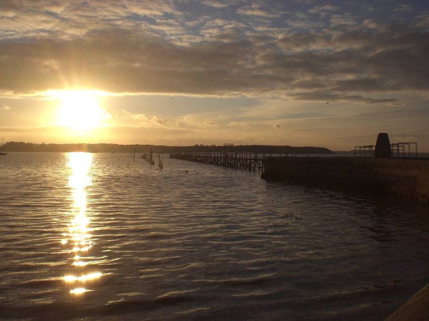
Sub-cell 5F-6 Handfast Point to Durlston Head
Landscape Environment
Handfast Point is dramatic promontory of chalk cliffs, rock stacks and the well known
landmark Old Harry and His Wife at its tip. Ballard Down is a large area of heathland
and is the eastern extent of the Purbeck Chalk Ridge.
Swanage Bay has a narrow, sandy and shingle beach, backed by the residential and
tourist seafront town of Swanage. Peveril Point and Durlston Head are headlands south
of Swanage while the landscape inland is rolling downland with grassland and farmland,
criss-crossed by drystone walls and hedgerows. Durlston Castle, located on Durlston
Head, is a Victorian folly built of locally quarried stone.
The coastal cliffs and fossiliferous rocks around Durlston Head are of international
geological importance; specifically, the Purbeck Beds at Durlston Head have yielded the
richest Lower Cretaceous fauna of fossil reptiles, fish, insects and mammals of that age
anywhere in the World. Durlston Bay (Figure 3.4) is also the most important late
Jurassic-early Cretaceous fossil insect site in Europe. Due to its high importance for
geological conservation the area has been designated a SSSl and is part of the World
Heritage Site for Jurassic Geology.
Coastal Environment
The area from Handfast Point to Durlston Head, similar to the east, supports vegetated
sea cliff communities and rare plant and animal communities that colonise in eroding
sea cliffs, such as early gentian. These are rare or threatened species protected by an
SAC designation.
Marine Environment
Swanage Pier supports rich assemblages of encrusting marine life, which are noted as
being of particular nature conservation importance (JNCC 1996). There are also
eelgrass beds in the area. The offshore sediments are composed of mixed sand,
shingle and maerl, some areas of which are dominated by the slipper limpet.
The limestone outcrops of the Ballard Ledges and softer chalk platforms at Handfast
Point add to the diversity of substrates and the respective encrusting organisms.
Limestone reefs and mussel beds occur off Durlston Head. This area is a spawning site
for Dover sole and cod, and a nursery for Dover sole. A variety of fish species, edible
crabs, spider crabs, lobsters, whelks and Pacific oysters are fished commercially.
Figure 3.4 Durlston Bay
Poole and Christchurch Bays SMP2 Appendix D 9T2052/R/301164/Exet
Report V3 D-24 2010You can also read