Vegetation Biomass Workshop Report - Forest Observation ...
←
→
Page content transcription
If your browser does not render page correctly, please read the page content below
Vegetation Biomass Workshop Report
   2016 NASA-ESA-Smithsonian Workshop on Calibration and Validation of Upcoming
                Satellite Missions on Forest Structure and Biomass

                                              May 31-Jun 3, 2016

                                   Smithsonian Institute, Washington DC

Report of a workshop jointly sponsored by NASA Earth Science Division, NASA Jet Propulsion Laboratory,
European Space Agency, Smithsonian Institute.
                                                      1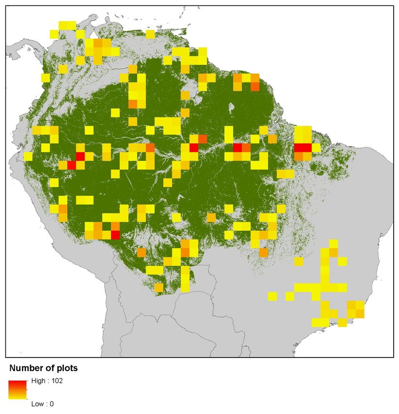
Compiled and Edited By:

Sassan Saatchi
Senior Scientist, Carbon and Ecosystem Group
Jet Propulsion Laboratory/CALTECH

Natasha Stavros
Scientist, Applications Program
Jet Propulsion Laboratory/CALTECH

Michael Keller
Scientist, Sustainable Landscape Program
USDA Forest Service

Stuart Davies
Director of ForestGEO
Smithsonian Institute

Klaus Scipal
BIOMASS Project Scientist
European Space Agency

Laura Duncanson
GEDI, Science Team Member
NASA, Goddard Space Flight Center

Acknowledgements

The organizers would like to thank all the participants in the Vegetation Biomass Workshop for their
scientific contributions during discussions and breakout sessions. We particularly thank Jerome Chave,
Shaun Quegan, John Armston and Keryn Paul for their participation in preparing the workshop report.

Suggested citation for this report: Saatchi S, Stavros N, Keller M, Davies S, Scipal K, Duncanson L
(2017) 2016 NASA-ESA-Smithsonian Workshop Report on Calibration and Validation of Upcoming
Satellite Missions on Forest Structure and Biomass. Jet Propulsion Laboratory, California Institute of
Technology.

                                                    2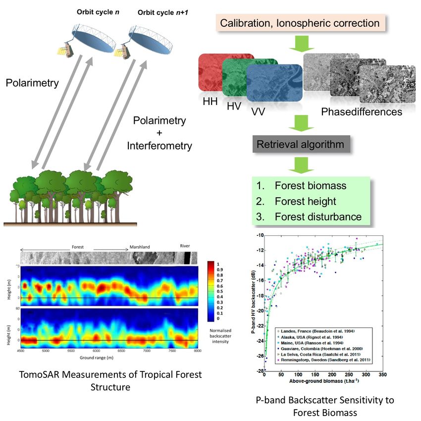
Table of Contents
1. Executive Summary ....................................................................................................... 3
2. Workshop Background .................................................................................................. 6
2.1. Forest Biomass ............................................................................................................................................................... 7
2.2. Missions ........................................................................................................................................................................... 8
2.2.1. GEDI (Launch: 2018-2019) ................................................................................................................................ 8
2.2.2. BIOMASS (Launch: 2021).................................................................................................................................... 9
2.2.3. NISAR Mission (Launch 2021) ....................................................................................................................... 10
2.2.4. Ground/Airborne Mission ................................................................................................................................ 12
3. Synergistic Opportunities (Day 1 Plenary and Breakout Sessions).............................. 13
3.1. Cross-Mission Synergism ....................................................................................................................................... 14
3.2. Ground-Space Synergism ........................................................................................................................................ 15
3.3. Synergism with Carbon/Climate Models ........................................................................................................... 15
4. Ground Data (Day 2 Breakout Sessions) ...................................................................... 17
4.1. National Inventory ..................................................................................................................................................... 17
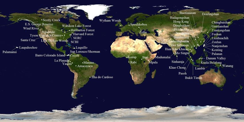
4.2. Supersites and Large Plots ...................................................................................................................................... 17
4.3. Research Plots ............................................................................................................................................................. 19
4.4. Airborne Lidar Datasets ........................................................................................................................................... 19
5. Calibration and Validation Plans (Day 3 Plenary and Breakout Sessions) .................. 20
5.1. CAL/VAL Methodological Requirements ........................................................................................................ 21
5.1.1. Allometry ................................................................................................................................................................. 21
5.1.2. Uncertainty............................................................................................................................................................. 22
5.2. CAL/VAL Data Requirements .............................................................................................................................. 22
5.2.1. Data Use ................................................................................................................................................................... 22
5.2.2. Data Gap .................................................................................................................................................................. 24
5.2.3. Data Enrichment.................................................................................................................................................. 25
5.3. CAL/VAL Trade Space ........................................................................................................................................... 26
1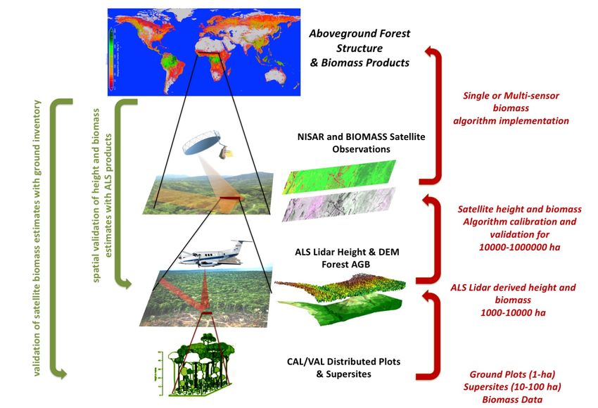
5.3.1.     Data Quality Requirements ............................................................................................................................. 26

     5.3.2.     Spatial Requirements ......................................................................................................................................... 26

     5.3.3.     Temporal Requirements ................................................................................................................................... 27

6.     CAL/VAL Implementation (Day 4 Breakout Sessions) ..................................................... 27

7.     Appendix I: Participant List ........................................................................................ 28

8.     Appendix II: Agenda .................................................................................................... 30

9.     Appendix III: Ground Networks represented at Workshop ............................................. 32

                                                                                    2
1. Executive Summary
This report summarizes presentations, findings and recommendations from the NASA-sponsored
Workshop on the calibration and validation of upcoming satellite missions that will produce global
measurements of forest Structure and biomass. The workshop was hosted by the Smithsonian Institute in
Washington DC, May 31-June 3, 2016 and was attended by 57 international participants (Appendix I),
representing a diverse mix of experts in remote sensing, forestry, ecology, and statistics.

The main goal of the workshop was to develop an integrated calibration and validation (CAL/VAL) plan
for future satellite missions dedicated to estimation of aboveground biomass (AGB). The workshop
focused on three spaceborne missions that are scheduled to be launched in the next 2-4 years: GEDI from
NASA, BIOMASS from ESA, and NISAR from a joint NASA-ISRO (Indian Space Research
Organization) collaboration. Although the missions have significant overlaps in science objectives and
products, they use different measurement techniques and algorithms to estimate different aspects of AGB
at varying spatial and temporal scales. Nevertheless, all three missions provide active remote sensing
measurements of forest structure that will be converted (calibrated) to estimates of AGB, which must then
be validated by ground/airborne-estimated AGB distributed globally in different forest types. These
ground/airborne observations by the ecological and forestry communities were recognized as constituting
a parallel, so-called “fourth mission”. This fourth mission provides ground/airborne measurements of
structure and algorithms for estimating AGB that have a direct link to space mission science requirements
and are integral to the CAL/VAL plan for these three missions.

The synergism of missions to produce global datasets of AGB necessitate international collaboration
among the scientists from each mission. By developing a collaborative CAL/VAL approach, all three
space missions benefit from sharing available resources of ground/airborne measurements, reducing the
cost of pre- and post-launch CAL/VAL operations while generating complementary and comparable
science products that benefit the ground/airborne-based mission.

The objectives of the workshop were to:

        •   Discuss synergism of the three space mission observations and products
        •   Develop joint CAL/VAL approaches and share resources
        •   Engage the global ground/airborne biomass observation community in CAL/VAL activities

Accordingly, the workshop agenda (Appendix II) highlighted five topics:

    1. Synergistic observations of the three space missions for developing global vegetation biomass
       products
    2. Ground/airborne mission measurements required for the success of all three space missions
    3. Development of a collaborative activity for pre- and post-launch CAL/VAL of the space missions
    4. Knowledge and data gaps on global forests
    5. Integration of forest science and statistics as components of the space mission product validation

The format of the four-day workshop included a combination of invited presentations and breakout group
discussions. The invited talks set the context for the workshop and provided background reviews of
information relevant to: the missions (ground/airborne and space), CAL/VAL requirements, sources of
uncertainty in estimations of AGB, available resources among international institutions and research
groups, data gaps, and potential resources for collection of data collection for pre- and post-launch
CAL/VAL activities. After each presentation participants discussed each talk and introduced discussion
topics such as recent technology for improving ground/airborne measurements of structure and
estimations of biomass, techniques for mitigating sources of uncertainty, and critical experiments and
research needs. Based on the presentations and discussions during the morning of each day as well as the
objectives for that day (associated with the five topics), a series of questions were developed to guide
further discussions in breakout sessions. These subsequent breakout sessions then focused deliberations
for developing an integrated CAL/VAL recommendations for the missions (Section 5 & 6). These

                                                    3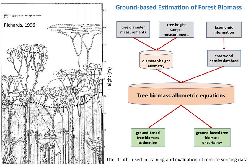
breakout sessions then reported back to the workshop as a whole on their findings. The workshop
concluded with a debrief discussion and input from the participants on key findings of the breakout
groups (Section 5).

Importantly, the workshop did not seek to plan any specific CAL/VAL activity for any of the missions,
but rather to develop a series of recommendations for each space mission when designing their CAL/VAL
plans. In particular, the workshop was able to identify which technologies, validation approaches, and
ground/airborne measurements might be best if implemented for each mission. Workshop participants
also identified resources, infrastructures, and capacities available within the international science
community (Appendix III and IV) that are useful for validating the space mission data products.

The following are key findings that resulted from the workshop.

    •   The space missions have significant overlaps in science objectives, algorithms, and data products,
        but focus on different measurement techniques at different spatial and temporal scales that result
        in observations of different components of AGB.
    •   All three space missions have open data policies to provide all Level 1 (calibrated and geolocated
        instrument measurements) and Level 2 (geophysical retrievals) data products along with
        algorithms and documents to the public.
    •   Combined satellite and ground/airborne observations of vegetation structure and biomass for
        synergistic products can answer long-standing questions in ecological and global carbon cycle
        science with greatly reduced uncertainty.
    •   The space missions have different internal CAL/VAL plans to meet each missions’ science
        requirements, but all plans leverage the same ground/airborne observations and require similar
        engagements of international institutions.
    •   There is a parallel “fourth mission” observing biomass that includes national forest inventories,
        research plot networks, and international monitoring organizations, and it is essential to include
        the “fourth mission” in a collaborative, synergistic CAL/VAL plan.
    •   Both ground/airborne and satellite observations of biomass are estimates with uncertainty that can
        be reduced significantly from synergism of observations and algorithms.
    •   Specific programmatic CAL/VAL activities would require coordination between NASA and ESA
        and the international community conducting ground/airborne-based forest inventory. Field
        campaigns such as AfriSAR was highlighted as an example of a programmatic CAL/VAL
        activity that fosters development of techniques for synergistic products from the three space
        missions.

From these findings, there were four key recommendations.

Recommendation 1: Support for synergistic data products

    •   Global maps of forest structure and biomass derived from all three space missions offer extended
        coverage, improved resolution, and reduced uncertainty and will be a significant contribution to
        the science and application community
    •   Potential new science products from the synergistic observations (e.g., spatially refined soil and
        vegetation moisture, or vertical profile of structure and biomass) will greatly enhance ecological
        and global carbon cycle science.
    •   Focus on synergistic products of biomass change from natural and human induced forest
        disturbance and recovery will directly address uncertainties in the global carbon cycle such as the
        location of terrestrial sinks and sources.

Recommendation 2: Support for a parallel ground/airborne biomass mission

    •   A parallel ground/airborne mission is the “fourth mission” that collects observations of AGB,
        necessary for a collaborative CAL/VAL plan.

                                                     4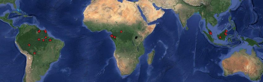
•   Although funding for this ground/airborne mission is outside the scope of the three space
       missions, partial support for ground/airborne data collection and maintenance of the network was
       recommended as part of the mission CAL/VAL plans.
   •   Data shared across space missions should be integrated into a central data portal.
   •   Work with international organizations (i.e. CEOS, GCOS, FAO, GOFC-GOLD, GOFI) is
       recommended for gaining more support for a central data center useful for CAL/VAL activities.

Recommendation 3: Support synergistic CAL/VAL activities

   •   Joint ESA-NASA airborne and ground field campaigns would augment the existing network of
       ground/airborne sites in regions with significant data gaps, thus contributing to space mission
       algorithm CAL/VAL.
   •   For selecting regions or sites for new CAL/VAL activities, existing AGB distributions and data
       products (e.g., NFI data, GlobBIOMASS and Saatchi Map) may be consulated to investigate
       patterns of large uncertainty or patterns of data gaps in structure or wood density
   •   Additional efforts to include uncertainty and error propagation methodology in algorithm and
       product validation could leverage formal statistical techniques (currently employed by the
       ground/airborne communities); as such expert statisticians could contribute to the mission science
       teams.

Recommendation 4: Support CAL/VAL workshops

   •   Annual workshops or meetings would engage a larger community of forestry and ecology
       scientists to contribute on synergistic space mission CAL/VAL activities.

                                                   5
2. Workshop Background
In May 2016, NASA, the European Space Agency (ESA) and the Smithsonian Institute (SI) co-sponsored
a workshop on the synergistic calibration and validation (CAL/VAL) activities of the upcoming active
remote sensing satellite missions tasked with estimating aboveground woody vegetation structure and
biomass. The workshop was held at the SI in Washington DC. The motivation of the workshop was to
discuss the different measurement techniques and algorithms used from each of the three upcoming active
remote sensing satellites and the current methodologies for CAL/VAL of their estimates of aboveground
biomass (AGB, the oven-dry weight of live vegetation in an ecosystem defined as the quantity of biomass
per unit area, or Mg dry weight ha-1). The workshop participants sought to generate approaches that could
evaluate the individual mission (or synergistic) science products, while providing a systematic method for
cross-mission CAL/VAL that is consistent with the synergistic objectives of all missions. This included
identifying ground/airborne measurements of structure and estimates biomass as well as detailed
discussions of uncertainties in these observations. The success of space observations depend strongly on
how well AGB is quantified at local (pixel) and regional scales. Finally, the workshop participants
developed a series of recommendations for CAL/VAL of the space missions’ data products that included
integrating existing data, identifying data gaps, and designing future ground and airborne campaigns in
different forest ecosystems globally.

The source of terms and definitions of calibration and validation may be different for each mission.
However, these are defined and used henceforth as:

        Calibration: A set of operations that establish the relationship between values of a measuring
        instrument (e.g. reflectance, vertical profile) and the corresponding values or quantities of
        interest realized by standards (ground-estimated aboveground height or biomass)

         Validation: The process of assessing the relationship or the quality of data products derived
        from a measuring instrument by independent means and reporting the uncertainty

The workshop focused on outlining CAL/VAL approaches, highlighting the most mature techniques for
reducing uncertainty in science data products, and recommending a series of high-priority CAL/VAL
activities that can be readily adapted to each missions’ requirements and potentially adopted by each of
the science teams and space agencies. Findings from the workshop include a set of practical
recommendations around the integration of existing ground/airborne datasets, standardization of biomass
estimation and uncertainty assessments from ground inventory, development and maintenance of a shared
platform for CAL/VAL data, and mechanisms to support the needed ground observations for CAL/VAL
throughout the operation of the space missions. Importantly, the workshop did not seek to develop
specific CAL/VAL plans for each of the upcoming missions, nor did it identify specific synergistic
science products or converge on any specific datasets or methodology for assessing the uncertainty of
estimated AGB. Rather, this report documents state-of-the-art options and reliable approaches for NASA
and ESA to consider in the CAL/VAL plans for each the upcoming space missions. The workshop was
also considered the first of a series sponsored by NASA and ESA to guide development of CAL/VAL
plans and synergistic science products that play a crucial role in linking space mission science products
and uncertainty to the needs and requirements of the stakeholders and the broader user community.

Participants included members from each of the space mission science teams, experts in forest ecology,
ecosystems, and climate models, as well as representatives from ground networks tasked with estimating
AGB, and program managers from ESA and NASA (Participant List in Appendix I).

                                                    6
2.1. Forest Biomass
The structure of forests (i.e., the three- dimensional arrangement of individual trees) is a direct indicator
of how much carbon is stored in the ecosystem. Carbon stored in an ecosystem has a profound effect on
how the ecosystem functions (e.g., how it cycles carbon, water, and nutrients). Additionally, there is an
increased need to understand local to global storage and dynamics of carbon in ecosystems, as carbon
storage is a prerequisite to understanding the coupling of the biosphere to other components of Earth
systems. For example, the amount of carbon in a system determines how much is eventually emitted to
the atmosphere (as CO2, CO, and CH4 through burning and decay) when ecosystems are disturbed from
deforestation and degradation or from climate driven stress and fire. The amount of carbon stored in the
system can be estimated from AGB, which is estimated from measurements of structure (e.g., the size and
density of trees) and the mass of trees. As such, AGB is considered a crucial variable for a range of
applications including forest fire assessment, management of the timber industry, monitoring land-use
change, and other ecosystem services such as biodiversity, and production of food and fiber as well as
greenhouse gas accounting.

Although we can account for many of these applications by using operational satellite observations of
forest cover change, our understanding of changes in terrestrial AGB remains rudimentary. For example,
we know that changes in land use, largely from tropical deforestation and fire, are estimated to have
reduced biomass globally, while the global carbon balance suggests that terrestrial carbon storage has
increased; albeit the exact magnitude, location, and causes of this residual terrestrial sink are still not well
quantified. There is strong evidence that the residual sinks are spread in different forest ecosystems with
locations that may change due to climate change and anomaly. Yet, the magnitude and fate of these
terrestrial sinks are crucial to projections of future climate and any uncertainties in the spatial locations or
the temporal behavior of them directly influences the current status of global carbon cycle and climate.

                                                                              Our knowledge of the distribution and
                                                                              amount of AGB is based almost
                                                                              entirely on ground measurements over
                                                                              an extremely small, and possibly
                                                                              biased, set of samples with many
                                                                              regions left unmeasured (Fig 1). At
                                                                              large scales, robust AGB estimates are
                                                                              acquired from ground-based forest
                                                                              censuses that are based on labor-
                                                                              intensive fieldwork (plot inventories)
                                                                              conducted by trained operators. As
                                                                              such, these plot inventories cannot be
                                                                              repeated frequently or at a low cost
Fig.1. The distribution of woody (forest and shrub land) area and biomass,
estimated by radar–LiDAR fusion compared to data avail-ability from forest
                                                                              everywhere. Thus, plot inventories are
inventory. The red histogram shows forest inventory plot density in 1000 km 2 limited to managed forests in a
grid cells1.                                                                  number of developed countries in the
                                                                              northern hemisphere where systematic
sampling of forest inventory are performed on a regular basis (5-10 year cycles). Information on most
carbon-rich global forests, particularly in developing and tropical countries, are missing even though this
is where most living biomass is located (63% of carbon in intact tropical forests, against 15% in boreal
forests and 13% in temperate forests, according to a recent and comprehensive estimate2). Furthermore,
land use activities along with increasing disturbance from climate and human stresses are rapidly
changing plot inventory requirements to include more frequent observations of forest ecosystems.

1
  Schimel, D., Pavlick, R., Fisher, J. B., Asner, G. P., Saatchi, S., Townsend, P., ... & Cox, P. (2015). Observing
terrestrial ecosystems and the carbon cycle from space. Global change biology, 21(5), 1762-1776.
2
  Pan, Y., Birdsey, R. A., Phillips, O. L., & Jackson, R. B. (2013). The structure, distribution, and biomass of the
world's forests. Annual Review of Ecology, Evolution, and Systematics, 44, 593-622.

                                                           7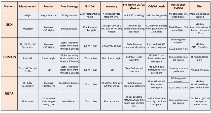
Consequently, quantitative spatial information about global forest AGB and AGB change has become the
priority of the science community and the broader community of stakeholders associated with
environmental policy, forest and timber industries, and local and national institutions dedicated to the
management of ecosystem services. The planned NASA and ESA biomass missions (GEDI, NISAR and
BIOMASS) are considered a direct response from the space agencies to this global science and
application priority.

2.2. Missions
2.2.1. GEDI (Launch: 2018-2019)

The scientific goal of the Global Ecosystem Dynamics Investigation Lidar (GEDI) is to characterize the
effects of changing climate and land use on ecosystem structure and dynamics to enable improved
quantification and understanding of the Earth's carbon cycle and biodiversity. Focused on tropical and
temperate forests from its vantage point on the International Space Station (ISS), GEDI uses a Light
Detection and Ranging (Lidar) sensor (near infrared 1064 nm wavelength) to provide the first global,
high-resolution (25 m) sampling observations of forest vertical structure. GEDI addresses three core
science questions: 1) What is the aboveground carbon balance of the land surface? 2) What role will the
land surface play in mitigating atmospheric CO2 in the coming decades? 3) How does ecosystem structure
affect habitat quality and biodiversity? Answering these questions is critical for understanding the future
path of global climate change and the Earth’s biodiversity.

                                                                           GEDI informs these science questions by
                                                                           collecting ~12 billion cloud-free land
                                                                           surface Lidar waveform (vertical profile)
                                                                           observations over a two-year mission
                                                                           lifetime. The instrument uses three laser
                                                                           transmitters split into five beams that are
                                                                           dithered to produce 10 parallel ground
                                                                           tracks of 25 m footprints (Fig 2). GEDI will
                                                                           produce estimates of canopy height,
                                                                           elevation, and vertical canopy profile
                                                                           measurements. The 25-m (~0.0625 ha)
                                                                           footprint measurements are used to model
                                                                           AGB and then used to derive mean AGB
                                                                           and variance on a 1-km grid.

                                                                           GEDI CAL/VAL Requirements

                                                                           From its vantage point on the ISS, GEDI is
                                                                           focused on tropical and temperate forests
                                                                           between 51.5° S and 51.5° N. The GEDI
                                                                           biomass calibration strategy is to develop
                                                                           globally representative pre-launch models
                                                                           for footprint AGB using near-coincident
                                                                           airborne laser scanning (ALS) data and plot
                                                                           inventory data. Mean and standard error of
                                                                           AGB for 1-km grid cells are then estimated
                                                                           from the modelled footprint AGB via
                                                                           statistical inference. The baseline
Fig 2. Distribution of GEDI footprints across the landscape from the       requirement for GEDI is that the standard
three lasers and multiple beams (above panel) and the typical              error of AGB estimates within 80% of Level
distribution of forest vertical structure captured by the GEDI footprint
                                                                           4B gridded product at 1 km cells will be <
level waveforms.
                                                                           20 Mg ha-1 or 20%, whichever is greater.

                                                                 8
Pre-launch CAL/VAL activities are focused on development and implementation of a framework for the
acquisition and processing of data with which to calibrate, test, and improve models and algorithms for
application to GEDI science data products. This requires:
1. The development of a global forest structure and biomass database representative of major forest
types to underpin calibration of empirical biomass models and assessment of GEDI performance.
2. Simulation of GEDI waveforms from ALS data and validation of these simulations using
NASA’s airborne Land Vegetation and Ice Sensor (LVIS) across major forest types.
3. Selection of prediction strata that includes variance that is representative of conditions in the
domain for which the empirical model parameters are being applied.
4. Use of large area (> 1000 ha) ALS data to validate assumptions of the estimators used for
statistical inference of the 1-km gridded AGB mean and standard error.
Post-launch CAL/VAL activities will verify the performance of these science algorithms, update the
calibration of any necessary algorithm parameters, and evaluate the science data products. Post-launch
validation efforts will therefore be focused at the footprint scale. This will require LVIS campaigns to
acquire waveforms and field plot data contemporaneous with GEDI orbital tracks, including areas with
ALS coverage and areas under-represented in the pre-launch calibration. For areas with high signal-to-
noise LVIS waveforms, height and cover metrics will be used to assess the quantity and quality of GEDI
data products and provide a basis for updating the footprint-level model calibration.
2.2.2. BIOMASS (Launch: 2021)
BIOMASS, the ESA’s seventh
Earth Explorer mission will be
launched in the 2020-21
timeframe and has the aim of
providing crucial information
about the state of the forests and
how they are changing globally.
The mission goal is to provide
estimates of height and AGB in
the world's forests. The science
case on which BIOMASS was
selected is based on its ability to
provide estimates of AGB within
dense tropical forests to monitor
their storage and changes from
disturbance at seasonal and
annual frequency. The
requirement for the BIOMASS
mission is to estimate forest
biomass with an accuracy of
£20% for more than 67% of
areas with biomass > 50 Mg/ha
on a 4-ha spatial grid cell (200 m
x 200 m pixels) every 6 months
for a period of five years of the
mission duration. This
Fig. 3. BIOMASS mission P-band SAR measurements showing the configuration of
requirement is achieved by using space measurements and the sensitivity of backscatter power and interferometry to
a P-band (70 cm wavelength) forest structure.
Synthetic Aperture Radar (SAR)
sensor, because of its unique
capabilities to penetrate even
9dense tropical forest. The measurements will provide radar polarimetric backscatter (HH, HV, VH, VV)
and interferometric observation with PolInSAR capability for forest height estimation, and TomoSAR
capability for backscatter vertical profile measurements1.
In addition, the BIOMASS mission will provide global maps of forest height at the same 4-ha spatial
scale for all forests > 10 m height with 30% accuracy, and include a 50 x 50 m deforestation map globally
every 6 months. These measurements together, will significantly improve our ability to reduce the
uncertainty in the global carbon cycle by providing spatially refined and temporally frequent observation
of carbon fluxes in forest ecosystems.
The coverage of BIOMASS is global with a restriction, imposed by the US Department of Defense Space
Objects Tracking Radar (SOTR) stations, over Europe and the North and Central Americas. Under these
restrictions, only 3% of AGB carbon stock coverage is lost in the tropical forest biome, which constituted
66% of global AGB carbon stocks in 20052. The loss is more significant in the temperate (72%), boreal
(37%) and subtropical (29%) biomes.
BIOMASS CAL/VAL Requirements
The CAL/VAL requirements of BIOMASS are primarily focused in tropical forest ecosystems, where the
bulk of mission observations are. The biomass and structure algorithms require large ground plots (> 4
ha) or Lidar-derived AGB estimates from airborne observations. These measurements must represent the
variations of tropical forest structural types and allometric characteristics and must be repeated during the
mission to allow validation of both biomass stocks and changes from disturbance and recovery. The
existing distribution of large (10-100 ha) permanent plots, designated as supersites, and of ALS
observations are considered the main source of data for algorithm calibration and BIOMASS product
validation. BIOMASS has identified several components of a plan to develop the CAL/VAL
methodology and datasets. These include:
1. The development of a quantitative framework and methodology to plan CAL/VAL activities.
2. The development and implementation of a Forest Observation System (http://www.forest-
observation-system.net/) for international cooperation that establishes and maintains a global in
situ forest biomass database for the BIOMASS mission CAL/VAL activities.
3. The focus of CAL/VAL mostly in tropical forests.
4. The regular re-visit of in situ forest plots for monitoring throughout the lifetime of the mission to
account for forest dynamics.
5. The enforcement of a strict data quality expectation for measuring AGB correctly.
2.2.3. NISAR Mission (Launch 2021)
NISAR is a joint project between NASA and ISRO (Indian Space Research Organization) to co-develop
and launch the first dual frequency SAR satellite. NASA will provide the L-band (24 cm wavelength) and
ISRO will provide the S-band (12 cm wavelength). The mission will acquire polarimetric and
interferometric observations at an unprecedented coverage in space and time, which is optimized for
studying changes of the global Earth surface.
1
Le Toan, T., Quegan, S., Davidson, M. W. J., Balzter, H., Paillou, P., Papathanassiou, K., ... & Ulander, L. (2011).
The BIOMASS mission: Mapping global forest biomass to better understand the terrestrial carbon cycle. Remote
sensing of environment, 115(11), 2850-2860.
2
Carreiras, J. M., Quegan, S., Le Toan, T., Minh, D. H. T., Saatchi, S. S., Carvalhais, N., ... & Scipal, K. (2017).
Coverage of high biomass forests by the ESA BIOMASS mission under defense restrictions. Remote Sensing of
Environment, 196, 154-162.
10NISAR will focus on the most dynamic ecosystems such as disturbed and recovering forests, inundated
wetlands, and croplands. NISAR will measure aboveground woody vegetation biomass and its disturbance
and recovery globally at the hectare scale; biomass accuracy shall be 20 Mg/ha or better for areas of woody
biomass £100 Mg/ha over at least 80% of these areas. Therefore, the mission will focus on areas of low
biomass, covering a significant portion of boreal, temperate and savanna woodlands. It will provide seasonal to
annual observations of biomass change in the most dynamic forests impacted by AGB disturbance and
recovery1.
The NISAR mission will be able to
provide L-band dual pol (HH, HV)
observations every 12 days in
ascending and descending orbits
covering global forests every 6 days.
These observations will be used to
produce maps of the distribution of
forest biomass at 1-ha grid cells. The
NISAR radar is designed for global
interferometric SAR (InSAR)
measurements, but the science
products produced do not include
direct information on the vertical
structure of forests. Rather, AGB is
estimated from backscatter
measurements and exploits either
empirical statistical approaches or
inversion of physically-based
scattering models that must be
calibrated over study sites globally to
capture the structural and composition
differences of forests in different eco-
regions. Fig 4. Schematic showing a typical northern conifer forest (a) simulated
to an ensemble of trees with stems, branches, and leaves (b) exposed to
NISAR CAL/VAL Requirements L-band radar energy with dominant scattering from forest components,
(c) suggesting the combined influence of structure and soil moisture on
radar backscatter with reduced sensitivity to biomass at higher
The CAL/VAL data required for aboveground biomass values (Haung et al. 2015). The last panel (d)
NISAR are similar and shows the sensitivity of radar backscatter at L-band HV polarization
complementary to those for GEDI and showing the sensitivity to biomass values < 100 Mg/ha with sample
data from the entire northern coniferous forests (Yu and Saatchi, 2016).
BIOMASS. The NISAR algorithm is
based on an analytical semi-empirical
model with coefficients that are calibrated with structure and biomass information from ground
measurements. The forest inventory data in calibration plots must be distributed in different eco-regions
and must be accompanied by ALS observations to extend the ground observations and enable validation
of the spatial variations of AGB. The size of plots used for calibration of the NISAR algorithm must be
either > 1-ha if used directly with the SAR data or smaller (~ 0.25 ha) if used in conjunction with the ALS
observations. In addition, forest inventory data can be used to evaluate and report the uncertainty of
NISAR AGB at the national or regional scale and for carbon accounting and assessments. In summary,
the general requirements for CAL/VAL of NISAR AGB are:
1. A systematic and quantitative framework to identify CAL/VAL regions of interests, number of
plots, number of airborne observations, and measurement requirements and protocols.
1
Yu, Y., & Saatchi, S. (2016). Sensitivity of L-band SAR backscatter to aboveground biomass of global forests.
Remote Sensing, 8(6), 522.
112. Ground plots to develop NISAR biomass algorithms for structurally, and ecologically distinct
forest types or forest eco-regions globally. The number of eco-regions may vary depending on
how sensitive the NISAR backscatter measurements are to structure and wood density variations,
and the scale of data analysis (1-ha). The number of ground plots for each forest type must be
enough to develop the model coefficients statistically (20-30 plots). The size of the plots depends
on their use; if used directly for calibration of NISAR algorithm they must be 1-ha, if used jointly
with ALS, they must be 0.25 ha. Selecting study sites with available ground and ALS data allows
for extension of the number of plots to larger areas (e.g. 1000 ha) that would provide spatial
biomass data to validate the performance of the algorithm locally and spatially.
3. Post-launch calibration of algorithms may be required to adjust the model coefficients to the
NISAR backscatter calibration characteristics. Once the algorithms are calibrated and validated
with ground plots and ALS, they can be used to estimate AGB from NISAR data.
4. NISAR AGB estimates can be validated using additional ground/airborne data at different spatial
scales. Specifically, post-launch validation of NISAR AGB requires either Lidar alone (if
collected in the same eco-regions or forest types as before) or Lidar and ground plots distributed
globally in different forest types. The validation study sites must be distributed within the same
forest types used for calibration but different locations to allow for independent and spatially
uncorrelated validation.
2.2.4. Ground/Airborne Mission
To make optimum
use of space borne
observations,
comprehensive
ground based
measurements of
forest structure are
required. The
ground-based
measurements are
needed to develop
the algorithms used
in the interpretation
of the satellite data
and to validate the
resulting products.
However, the
ground-based
measurements and
their conversion to
AGB follow a
similar approach as Fig. 5. The ground mission is focused on measurements of tree structure at sample plots and
the remote sensing the estimation of the forest aboveground biomass and carbon stocks along with associated
uncertainty to be used for calibration and validation of remote sensing data.
data. The ground
measurements of
forest structure must be converted to forest biomass using an algorithm that provides estimates of biomass
and the uncertainty at plot scale (Fig. 5). Therefore, the ground or “fourth mission” identified in the
workshop must be included in the overall goal of quantifying forest biomass and carbon stocks from
NASA and ESA’s remote sensing missions. Ecology and forestry scientist participation in space mission
CAL/VAL must not be limited to “data providers,” but as an integrated part of the overall efforts to
ensure that products from the space missions have high fidelity and accuracy.
The engagement of ground-based forest observation programs requires that the remote sensing
community is informed of the constraints (e.g., costs) of long-term forest monitoring for ecological
research and national forest inventory. Similarly, ecologists and foresters must be informed about
12upcoming space missions so that they can learn how these could serve their science. The underlying data
collection endeavors of the fourth mission concept depend on and impact research across disciplines. As
such, they would ideally be part of a long-term research infrastructure program with its own funding
mechanisms. By establishing links to space observations, these networks can reach out to a larger
community, which may have access to larger resources for funding in order to maintain and improve the
infrastructures, data acquisition, and distributions. In this context, ESA took a first step and implemented
the Forest Observation System (http://www.forest-observation-system.net/). The Forest Observation
System is a platform to collect, harmonize and share data from existing networks. Funding for this
platform is maintained by ESA, but does not cover the actual collection of data and hence relies on the
support from existing networks.
The ground mission, therefore, has the following goals:
1. The development of a methodology for identification and acquisition of ground measurements for
biomass estimation that would be useful for CAL/VAL of remote sensing data, and backwards-
compatible with existing practice of data collection in ecology and forestry.
2. The definition and implementation of a set of quality-control criteria to select ground-based
measurements across forest types and eco-regions that includes identified and quantifiable
sources of errors in the ground-based estimation of forest biomass.
3. The development of a database of a global network of sample plots that meet the uncertainty
requirements and sample size necessary for remote sensing CAL/VAL.
4. The development of synergistic approaches to combine ecology and forestry science AGB
estimates with remote sensing measurements of structure and estimates of AGB.
3. Synergistic Opportunities (Day 1 Plenary and Breakout Sessions)
Synergism of the measurements for global products was the topic of the first day of the workshop that
included a review of the measurements, algorithms, and products of each mission (Section 2) with
breakout sessions on mission synergies including different opportunities for synergism between ground
and space observations as well as integration into ecosystem models. Specifically, each space mission has
a need for validating their AGB biomass products, which requires collaboration with the international
community of forest ecologists and statisticians, who have the knowledge and ground data on forest
biomass distributions. This mutual need by the space missions necessitates collaboration among scientists
Table 1. Summary of the NASA and ESA space mission characteristics to be considered for the cross-mission synergistic
biomass products.
13and space agencies throughout product development to enable implementation of standards for consistent
validation, utilization of shared resources and data from in situ measurements, and integration of
stakeholder requirements.
3.1. Cross-Mission Synergism
All three missions have significant overlaps in science objectives and products, but focus on different
observations, covering different regions, and retrieving different components of AGB at different spatial
and temporal scales. The cross-mission synergism is based on the following observations and
assessments from the breakout sessions:
a. Area coverage, and the science products from the space missions are immediately recognized as
complementary such that without the data from all the missions, wall-to-wall coverage and estimation
of the global forest biomass are impossible (Fig. 6). BIOMASS focuses on tropical and sub-tropical
woodlands at 4-ha, while NISAR is global but limited to areas of low forest biomass at 1-ha, and
GEDI not limited by AGB, but with limited coverage collecting sample footprints within +/-50
Fig. 6. Maps of coverage of ESA and NASA satellite measurements of forest structure and biomass. The background shows
the global coverage area of the NISAR mission and the sensitivity of NISAR to aboveground biomass values < 100 Mg/ha
(green and yellow). The BIOMASS mission coverage includes the tropical belt and a portion of the northeast Siberia and the
GEDI Lidar sampling coverage from the International Space Station (ISS) between ± 50 degrees latitude.
degrees latitude.
b. Differences in biomass components retrieved by each space mission suggest that a synergistic global
AGB product cannot be mechanistically produced by combining the maps, but rather requires a
systematic data fusion approach. For reference, BIOMASS will estimate AGB when woody biomass
is > 50 Mg/ha, NISAR will estimate AGB when woody and leafy biomass is < 100 Mg/ha, and GEDI
will estimate AGB for the entire range from height measurements within each 25 m footprint.
c. Leverage the sensitivities of each measurement approach to cross-calibrate space mission
products can be achieved by using the measurements and products of one mission to CAL/VAL the
algorithm or products of other missions. Although every space mission has a different method for
estimating AGB, thus making it difficult to directly compare between products, an approach could be
used that compares either similar lower level products or leverages different algorithm sensitivities
(e.g., NISAR can provide more robust estimates for forests with 20 Mg/ha than for grasslands with £5
Mg/ha). For example, GEDI forest height may be used to develop and verify algorithms for the
BIOMASS tomography-derived tree height. Similarly, height or backscatter products from NISAR
and BIOMASS missions can provide information on the spatial variability of forest structure and
biomass to improve the algorithm and resolution of GEDI height and biomass gridded products.
d. NISAR and BIOMASS measurements spatially overlap, thus enabling data fusions such as: 1)
the combined measurements of L-band P-band for improving the estimates of low biomass forests, 2)
the use of higher temporal frequency NISAR observations to reduce the effects of soil moisture and
vegetation phenology on the BIOMASS estimation approach, 3) the deployment of a two-frequency
14algorithm to enable estimation of leaf, branch, and stem biomass, and 4) the use of combined
measurements to increase sensitivity of the observations for detecting low-impact forest degradation
and slow recovery.
e. Additional ecological science products may be produced from synergistic integration of data that
enables exploration of the physical characteristics of each measurement. For example, other forest
variables such as basal area, volume, branch, leaf, and stem biomass, and forest stand wood density
may be derived using the combined sensitivity of radar observations to dielectric constants and tree
stem and crown volumes, and ability of Lidar waveforms to measure the vertical distributions and
canopy gaps.
3.2. Ground-Space Synergism
An important finding was space missions must consider how their work benefits ground and airborne
project objectives. One benefit is that space missions provide a means for understanding regional or
global change, specifically with respect to heterogeneity of ecosystems, biodiversity, and social response
(e.g., policy, economy, etc.). Another benefit is the sensitivity of the different space measurements of
forest structure to better constrain allometric equations used for estimating tree height, canopy crown area
and trunk diameter. The key findings from the breakout sessions can be summarized as:
a. Forest heterogeneity and upscaling of small-scale measurements at the plot level can be integrated
with remote sensing observations to inform landscape and larger scale ecological characteristics of
the forests. Variability and heterogeneity of forest structure may not be captured in research plot
networks due to difficulty and cost of large-scale sampling. Space mission data on forest structure and
biomass from GEDI 25 m footprints to the 100 m NISAR and 200 m BIOMASS spatial grids can
help upscale detailed information of plot data to landscape (100-10000 ha) and regional scales where
environmental controls and climate and land use disturbances interact with forest function.
b. Large-scale drivers of dynamics can be assessed by combining the measurements from ground plots
to changes in remotely sensed observations of forest structure and canopy characteristics. Specifically,
mission data can facilitate interpolation between ground and remote sensing measurements that would
be useful for improving understanding of drivers of tree growth and mortality (from drought,
pathogen outbreak, storms, etc.) as well as improving estimates for rates of carbon accumulation in
secondary forests.
c. The spatial and temporal characteristics of remote sensing data can improve relationships
between forest ecological and biological characteristics. Specifically, communities of plants
consist of many species, which are thought to live within an ecological niche, that can be defined by
the canopy as it reduces the rate of airflow, thus maintaining high and constant atmospheric humidity
and other abiotic factors inside the forest.
d. Carbon accumulation rate, sinks and sources of forest ecosystems and their contributions to global
carbon cycle are currently based on long-time monitoring of individual permanent research plots that
include time series measurements of forest structure dynamics. These measurements are
comprehensive at the plot locations but lack systematic and widespread sampling. When combined
with spatially explicit remote sensing observations of forest structure and biomass, these
comprehensive measurements can be potentially upscaled and extrapolated over larger scales.
3.3. Synergism with Carbon/Climate Models
Satellite observations of forest structure and biomass changes from disturbance and recovery can be
integrated into Earth System Models (ESM)1 used for simulating and predicting the response of terrestrial
ecosystems to atmospheric changes in temperature, precipitation and CO2 concentrations. Within these
models, a core set of coupled modules, known as Dynamic Global Vegetation Models (DGVMs),
1
Fisher, R. A., Koven, C. D., Anderegg, W. R., Christoffersen, B. O., Dietze, M. C., Farrior, C. E., ... & Lichstein,
J. W. (2017). Vegetation demographics in Earth System Models: A review of progress and priorities. Global change
biology.
15represent the interactions of ecosystem carbon and water exchanges with vegetation dynamics, under
given soil and atmospheric conditions. The great strength of such models are their predictive capability;
by accurately representing the biophysical processes involved, these models can estimate the long-term
behavior of vegetation systems under changing climate and atmospheric CO2 concentrations. To date,
when applied at the global scale, these models use generalized descriptions of the system extracted from
ground-based inventories of the plant canopy structure and traits from within small sample plots. The
models therefore suffer from large uncertainty in predicting carbon fluxes at larger scales. However, these
generalized descriptions of vegetation surface can benefit from integrating more realistic and accurate
surface parameters such as forest structure (height, vertical profile), AGB, disturbance and recovery
processes, and plant functional types in terms of size and wood density. The breakout session identified
several synergistic activities to link models and the products of the satellite missions for reduce
uncertainty in model predictions of ecosystem responses to various current and future climate and land
use disturbances:
a. DGVMs can be assimilated with biomass stocks. Many DGVMs have already
assimilated forest biomass from radar and Lidar data at local or regional scales1 and it
is predicted that the space missions’ biomass data can be readily ingested in the
models. In particular, for large-scale model simulations of fluxes, regional and
continental scale biomass maps can be used to provide distributions of biomass
variations in modeling grid cells2.
b. Height-diameter or biomass relationships are varied across landscapes and regions
due to variations of edaphic factors, climate, and nutrient availability. Process-based
models of vegetation (e.g., DGVMs) often include processes contributing to stand
dynamics such as crowding competition and self-thinning laws. If these models are
calibrated using assimilated structure data from remote sensing they can make
realistic predictions of height-biomass relationships through time.
c. AGB is an emergent diagnostic of models at the ecosystem level as it can be directly
used to set the turnover or resident time of carbon. The turnover time is derived from the
ratio of total carbon to gross primary production (GPP) of ecosystems. Because changes
in the turnover time of carbon in land ecosystems partially determines the feedback
between the terrestrial carbon cycle and climate, maps of AGB from the space missions
can be used to evaluate the models at more local scales3.
d. Transient changes of biomass from land use, climate and natural regrowth are being
readily ingested into models to improve the estimation of carbon fluxes spatially, which
may help constrain and improve the detection of changes by remote sensing sensors.
Currently, there is no clear method for how to accurately detect change via the NISAR or
BIOMASS algorithms, nor is there a method by which to validate such a product. As such,
detecting changes of forest structure and AGB from either NISAR or BIOMASS may be
subject to large uncertainty, particularly when the changes are small. However, this
uncertainty may be reduced at the aggregate scale of modeling grid cells.
1
Antonarakis, A. S., Saatchi, S. S., Chazdon, R. L., & Moorcroft, P. R. (2011). Using Lidar and Radar
measurements to constrain predictions of forest ecosystem structure and function. Ecological Applications, 21(4),
1120-1137.
2
Hurtt, G. C., Fisk, J., Thomas, R. Q., Dubayah, R., Moorcroft, P. R., & Shugart, H. H. (2010). Linking models and
data on vegetation structure. Journal of Geophysical Research: Biogeosciences, 115(G2).
3
Carvalhais, N., Forkel, M., Khomik, M., Bellarby, J., Jung, M., Migliavacca, M., ... & Weber, U. (2014). Global
covariation of carbon turnover times with climate in terrestrial ecosystems. Nature, 514(7521), 213-217.
164. Ground Data (Day 2 Breakout Sessions)
Matching data needs for space mission CAL/VAL to data availability and identifying data gaps requires
the review of data sources and an understanding of data quality and uncertainty. Thus, workshop
participants discussed a general methodological framework that outlines the use of ground/airborne forest
structure measurements and AGB estimates that can inform the space mission CAL/VAL plans. In
deriving these CAL/VAL requirements for each mission, an important consideration is the need to
leverage large comprehensive dataset at a few supersites versus multiple smaller plot networks or national
inventory data. The plenary and breakout sessions identified four sources of data that can be integrated in
the mission CAL/VAL plans: 1) National Inventory, 2) Supersites and Large Plots, 3) research plots, and
4) ALS. Appendix III and Appendix IV provide lists of identified ground/airborne data.
4.1. National Inventory
National forest inventories (NFI) are used to give unbiased carbon estimates at national or regional levels
and are based on systematic or statistical sampling of the forest structure, conversion of the structure to
biomass or carbon density using a model, and estimation of mean or total carbon density and the
uncertainty over large regions. NFIs are considered the gold standard of forest carbon assessment at
national and regional scales, particularly in some countries located in the northern hemisphere temperate
and boreal regions.
There has been a significant intellectual work based on statistical techniques incorporated into these NFI
systems that can contribute to the CAL/VAL plans and uncertainty assessments for each space mission. In
particular, NFI data are based on a large number of small plots and model estimators that provide large-
scale estimates of carbon stocks with very low uncertainty. These individual plots cannot be directly used
for remote sensing CAL/VAL, but they can be used for regional scale validation. Furtheremore, the NFI
plot data can be used to calibrate airborne small footprint Lidar data to predict biomass spatially that can
be further resolved at grid cells compatible with measurements and AGB products from each space
mission. Alternatively, sub-national spatial information at state or county levels can provide unbiased
spatial variations of forest biomass that can be used for validation of AGB patterns inferred from mission
products. To take full advantage for the statistical designs incorporated in the NFI data, it may be
necessary to include collaborators with forest biometric and statistical expertise in the mission science
teams.
When using NFI data for validating space missions, the data must be ranked depending on quality and
use with different remote sensing techniques. Only well-established NFI systems (currently,
predominantly from temperate or boreal forests) with accurate GPS locations and detailed information on
structure and species are recommended to be used for remote sensing modeling and validation of the
space mission AGB products. Using such high quality and available national inventory data to validate
remote sensing products can increase the applications and use of mission products to a larger community
as it will improve the quality of missions’ science products by standards used in the forestry and carbon
accounting communities.
The biggest disadvantage of using NFI data for space mission CAL/VAL, is the lack of access to the data
due to strict government regulations for data dissemination, particularly with respect to exact plot
geolocations. Large-scale validation, however, may not require coordinate locations of the plots. Yet, if it
is necessary, free access to NFI data with locations may become possible through agreements with the
space missions.
4.2. Supersites and Large Plots
The relation between SAR signal (backscatter intensity, PolInSAR) and Lidar waveforms when
estimating AGB depends on factors known to affect the relationship between forest biomass and forest
height and other structural factors such as stand-scale wood density (which we know varies along
gradients of elevation, moisture, biogeography, and disturbance) and canopy height vs. basal area
relationships. Having study areas with detailed measurements of forest structure provides parameters
17You can also read