Monitoring our changing planet - Critical spectrum for Earth observation from space - ITU
←
→
Page content transcription
If your browser does not render page correctly, please read the page content below

No. 1, 2019

Monitoring our
changing planet
Critical spectrum for Earth
observation from space
Editorial

       Monitoring our changing planet
       Houlin Zhao

       ITU Secretary‑General

       The Earth is a fragile planet with finite resources to sustain the world’s
       growing population. As we work together to build a sustainable global
       economy, spaceborne remote sensors are poised to play an increas-

                                                                                    “
       ingly important role in achieving the United Nations’ Sustainable
       Development Goals (SDGs).

       Indeed, ITU Member States and the global community now see the
                                                                                     Remote sensing
       potential for using Earth observations and geospatial information              measurements
       as fundamental inputs for achieving the SDGs. Remote sensing                        — and the
                                                                                         science they
       provides critical information across a wide range of applications,
       including air quality, disaster management, public health, agriculture,
       water availability, coastal zone management, and the health of the           enable — provide
       Earth’s ecosystems.
                                                                                      a great service
       For example, spaceborne sensing data is used to assess the impact                to humanity.
       of natural disasters and to be better prepared for hazardous events
       around the globe. Data from spaceborne remote sensors is also                         Houlin Zhao
       increasingly used to guide efforts to minimize the damage that urban
       growth has on the environment.

       These are just a few examples of how remote sensing measurements
       — and the science they enable — provide a great service to humanity.
       This edition of the ITU News Magazine provides more such examples                                   1
       and a wealth of insight into how ITU’s work helps realize the social and
       economic benefits of Earth observation from space.

       In addition, I am pleased to acknowledge that the ITU News Magazine
                                                                                                           ITU News MAGAZINE 01/2019

       has turned 150. In this edition you will also discover milestones in the
       150-year history of ITU News.

       I take this opportunity to wish you all a very healthy and happy
       New Year!
Contents

      Monitoring our changing planet
      Critical spectrum for Earth observation from space

      1    Monitoring our changing planet
           Houlin Zhao
           ITU Secretary‑General

                                                                        Cover photo: Shutterstock/NASA
      Space science — ITU and WRC‑19

      4    Why we need space sensing observation today
           Mario Maniewicz
           Director of the ITU Radiocommunication Bureau

      8    Earth observation systems — ITU–R Study Group 7 and
           World Radiocommunication Conferences
           John Zuzek
           Chairman of ITU–R Study Group 7, and National
           Spectrum Program Manager, NASA
                                                                        ISSN 1020–4148
                                                                        itunews.itu.int
      Benefits of Earth observation from space                          Six issues per year
                                                                        Copyright: © ITU 2019
      12 The space-based component of the WMO Integrated
         Global Observing System                                        Editor-in-Chief: Matthew Clark
           Petteri Taalas                                               Art Editor: Christine Vanoli
           Secretary-General, World Meteorological Organization (WMO)   Editorial Assistant: Angela Smith

                                                                        Editorial office/Advertising information:
      16 The importance of the radio spectrum for Earth                 Tel.: +41 22 730 5234/6303
         observation                                                    Fax: +41 22 730 5935
           Eric Allaix                                                  E‑mail: itunews@itu.int
           Chairman, Steering Group on Radio Frequency Coordination
                                                                        Mailing address:
      19 Altimetry from space                                           International Telecommunication Union
                                                                        Place des Nations                                               2
           Jean Pla                                                     CH–1211 Geneva 20 (Switzerland)
           Vice Chairman, ITU–R Study Group 7
                                                                        Disclaimer:
      24 Passive bands atmospheric sensing and selection                Opinions expressed in this publication are those of the
                                                                        authors and do not engage ITU. The designations em-
           Richard Kelley
                                                                        ployed and presentation of material in this publication,
           Spectrum Manager, Alion Science and Technology,
                                                                                                                                        ITU News MAGAZINE 01/2019

                                                                        including maps, do not imply the expression of any
           National Oceanic and Atmospheric Association                 opinion whatsoever on the part of ITU concerning the
           (NOAA), United States Department of Commerce                 legal status of any country, territory, city or area, or con-
                                                                        cerning the delimitations of its frontiers or boundaries.
      30 Monitoring weather and climate from space —                    The mention of specific companies or of certain prod-
         indispensable for our modern global society                    ucts does not imply that they are endorsed or recom-
                                                                        mended by ITU in preference to others of a similar
           Markus Dreis                                                 nature that are not mentioned.
           Chairman of ITU–R Working Party 7C,
           Frequency Manager, EUMETSAT                                  All photos are by ITU unless specified otherwise.
Contents

      36 Active spaceborne sensing for Earth study and natural
         disaster prediction
           Bryan Huneycutt
           ITU remote sensing delegate, Jet Propulsion Laboratory,
           California Institute of Technology, NASA

      41 How passive remote sensors are used to predict the
         weather
           Yu Yang
           Engineer, National Satellite Meteorological Center,
           China Meteorological Administration (CMA)

      44 Protect Earth observation sensor spectrum for societal
         good
           Gilberto Câmara
           Secretariat Director, Group on Earth Observations (GEO)

      Dealing with harmful interference

      47 The interference problem for passive sensing on a global
         scale
           Josef Aschbacher
           Director of Earth Observation Programmes,
           European Space Agency (ESA)

      54 The importance of passive microwave remote sensing for
         numerical weather prediction and how WRC‑19 can deal
         with radio-frequency interference
           Stephen English
           Head of the Earth System Assimilation Section, European
           Centre for Medium-Range Weather Forecasts (ECMWF)

      59 Milestones in the 150‑year history of ITU News

                                                                     3
                                                                     ITU News MAGAZINE 01/2019
Space science — ITU and WRC‑19

      Why we need
      space sensing
      observation today
      Mario Maniewicz

      Director of the ITU
      Radiocommunication Bureau

      C
                 limate change and growing
                 exploitation of the Earth’s natural
                 resources is leading to a range of
                 environmental problems that require
      international action.

                                                           “   Today, several
      If humanity is going to respond effectively, many
      of the solutions will be informed by global mon-
      itoring of the environment, including the use of        dozen satellites
      space assets.
                                                            contribute to the
      Indeed, space sensing observation is essential to     accumulation of
      help leaders and citizens make better decisions     critical knowledge
                                                           about the Earth’s
      based on reliable data.

      Today, several dozen satellites contribute to the               system.
      accumulation of critical knowledge about the                                  4
      Earth’s system, enabling scientists to describe             Mario Maniewicz
      specific links between a major natural distur-
      bance in the upper atmosphere, and changes in
      the weather thousands of miles away.
                                                                                    ITU News MAGAZINE 01/2019
Space science — ITU and WRC‑19

                                                                                                                Shutterstock
      As accurate weather predictions need to start         The Global Climate Observing System —
      from the best possible estimate of the current        A United Nations Framework
      state of the atmosphere, it is crucial that meteor-
      ologists have real-time, accurate global obser-       The need for observations is formally addressed
      vations about what is happening in the Earth’s        through the United Nations (UN) Framework
      atmosphere over land and oceans. And for this,        Convention on Climate Change which has
      they rely on space sensing.                           charged the Global Climate Observing System
                                                            with the responsibility for defining requirements
      Satellite data is today an indispensable input        for observations relevant to climate change. All
      for weather prediction models and forecast
      systems used to produce safety warnings and
                                                            concerned UN agencies work together to ensure
                                                            the sustained provision of reliable physical,
                                                                                                                               5
      other information in support of public and pri-       chemical and biological observation and data
      vate decision-making.                                 records in order to contribute to the achievement
                                                            of each one of the 17 Sustainable Development
                                                            Goals and their associated targets.
                                                                                                                               ITU News MAGAZINE 01/2019
Space science — ITU and WRC‑19

                                                                   “ It is crucial that
                                                                 meteorologists have
                                                                  real-time, accurate
                                                                 global observations
                                                                        about what is
                                                                    happening in the
                                                                 Earth’s atmosphere.
                                                                                     Mario Maniewicz

      28 October – 22 November
        Sharm El-Sheikh, Egypt

                                                        Spectrum — crucial for
                                                        meteorological systems

                                                        It is therefore important for the readers of this
                                                        ITU News Magazine edition to understand why
                                                        the availability and protection of appropriate
                                                        spectrum for meteorological systems is crucial
                                                        for their performance, and why the potential
      The ITU World Radiocommunication                  economic and societal value of these systems
      Conference 2019 — taking decisions                deserve special attention from the ITU mem-
      on spectrum                                       bership to the needs of the space science
                                                        community. I am very grateful to the authors for
      This edition of the ITU News Magazine is pub-     sharing their expertise and perspectives.
      lished in the context of the preparation of the
      ITU World Radiocommunication Conference
      2019, to be held from 28 October to
                                                                                                            6
      22 November 2019 in Sharm El‑Sheikh, Egypt.

      The conference will take decisions on the use
      of spectrum by the various radiocommuni-
                                                                                                            ITU News MAGAZINE 01/2019

      cation services, including space science. It is
      essential that these decisions provide appro-
      priate protection to space science so that it
      continues to support the sustainable develop-
      ment of humankind.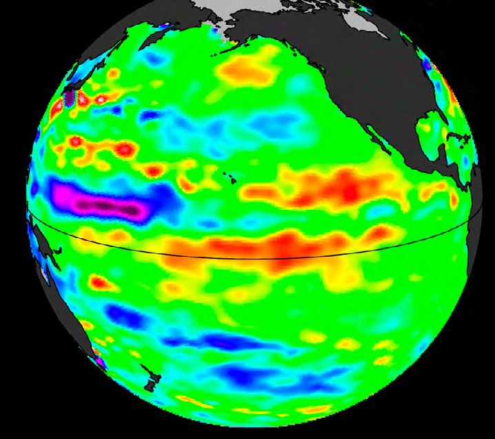
Space science — ITU and WRC‑19

      Types of spaceborne remote sensors for Earth observation

                        Active sensors are radar systems on spaceborne
                      platforms. They obtain data through the transmission
                         and reception of radiowaves. There are 5 types:

Synthetic aperture                Altimeters           Scatterometers            Precipitation            Cloud profile
  radars (SARs)                                                                     radars                   radars
Obtain topographical         Measure the precise         Determine wind         Determine rainfall     Measure cloud cover
 data of the Earth’s         height of the ocean’s   direction and speed at   rates and 3D structure   and structure over the
      surface                       surface            the ocean’s surface           of rainfall          Earth’s surface

                      Passive sensors are very sensitive receivers that
                      measure the electromagnetic energy emitted and
                   scattered by the Earth, and the chemical constituents in
                    the Earth’s atmosphere. They require protection from
                                 radio-frequency interference.

                           Your source to ITU–R Recommendations

                                  ITU Radiocommunication Sector (ITU–R)
                                     Study Group 7 (Science Services)

        Your source to ITU–R Recommendations that describe the technical and operational
        characteristics, protection criteria, and sharing considerations for remote sensing satellite
        systems and their associated control and data return links:
                                                                                                                                7

                   RS Series (for remote sensing)
                                                                                                                                ITU News MAGAZINE 01/2019

                   SA Series (for space applications and meteorology)

                   Handbook on Earth Exploration-Satellite Service

                   Joint WMO-ITU Handbook on Use of Radio Spectrum for Meteorology:
                   Weather, Water and Climate Monitoring and Prediction

 Source: ITU Radiocommunication Sector (ITU–R)
Space science — ITU and WRC‑19

      Earth observation
      systems — ITU–R Study
      Group 7 and World
      Radiocommunication
      Conferences
      John Zuzek

      Chairman of ITU–R Study Group 7, and
      National Spectrum Program Manager, NASA

      T
               he ITU Radiocommunication Sector
               (ITU–R) Study Group 7 deals with

                                                            “
               science services. These include
               the Earth exploration-satellite and
      meteorological-satellite services, with systems for     Data from Earth
      passive and active spaceborne remote sensing,            observation and
      which enable us to obtain important data about
      the Earth and its atmosphere
                                                                remote sensing
                                                              systems are used
      The systems used for these purposes have
      far-reaching effects for everyone on the planet.
                                                             in applications for
      The data are used to study and monitor climate        disaster prediction,
      change, to assist meteorologists in predicting the        monitoring and
      weather, and predicting and monitoring a variety
                                                                     mitigation.     8
      of natural disasters.

                                                                        John Zuzek
      It is important to note that while meteorological
      and Earth observation satellites are operated by
      only a limited number of countries, the data and
                                                                                     ITU News MAGAZINE 01/2019

      data products that result from their operation
      are distributed and used on a global basis, in
      particular by national weather services, in both
      developed and developing countries, and by
      organizations monitoring and studying climate
      change.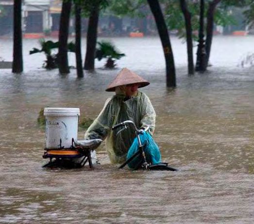
Space science — ITU and WRC‑19

                                                                 Approximately 90% of all
                                                                 disasters are weather-related.

                                                                                                                                             IRIN/Tung X. Ngo
      Furthermore, data from Earth observation and
      remote sensing systems are used in applications
      for disaster prediction, monitoring and mitiga-
      tion. A United Nations report found that approx-
      imately 90% of all disasters are weather-related.
      Due to the global nature of Earth observation
      and remote sensing systems, protection from
      harmful interference has to be considered on a
      global basis.
                                                           Passive remote sensing instruments operating on
                                                           Earth observation satellites are looking down at
      Spaceborne active sensors                            the Earth’s surface and atmosphere, and are sus-
                                                           ceptible to interference from transmitters oper-
      Spaceborne active sensors are instruments            ating on or near the surface of the Earth. These
      that obtain data through the transmission and        sensitive receivers can only operate successfully
      reception of radiowaves. They are basically          due to the allocation of certain frequency bands
      radar systems on spaceborne platforms. There         to their respective radio services and due to the
      are five types of active sensors, each having its    regulatory protections afforded to them by many
      own specific purpose. The synthetic aperture         special provisions of the Radio Regulations.
      radar (SAR) is used to obtain topographical data
      of the Earth’s surface. Altimeters are used to       In fact, by their very nature, passive sensors are
      measure the precise height of the ocean surface.     attempting to receive and process very weak, nat-
      Scatterometers are primarily used to determine       urally occurring radio signals at specific frequen-
      the wind direction and speed at the ocean sur-       cies determined by molecular physics. Therefore,
      face. Precipitation radars are used to determine     if such signals are corrupted by interference, it
      rainfall rates and the three-dimensional structure   is not possible to simply use another frequency
      of the rainfall. Cloud profile radars are used to    to obtain the information. The information is
      measure cloud cover and structure over the           simply unavailable.
      Earth’s surface.
                                                           Once scientific data is obtained by Earth observa-
                                                           tion sensor systems, this data must be transmitted
                                                                                                                 9
      Spaceborne passive sensors                           down to the Earth for scientists to process and
                                                           make use of that data. These data transmis-
      Spaceborne passive sensors are very sensitive        sion links must also be protected from harmful
      receivers known as radiometers that measure the      radio-frequency interference, or the scientific
                                                                                                                 ITU News MAGAZINE 01/2019

      electromagnetic energy emitted and scattered         data may be corrupted or lost entirely.
      by the Earth and the chemical constituents in
      its atmosphere. These very sensitive receivers
      require protection from radio-frequency interfer-
      ence in order to be able to make their requisite
      measurements.
Space science — ITU and WRC‑19
See all ITU–R Study Group 7
recommendations for:
Remote sensing systems: RS series
Space applications and meteorology: SA series.
ITU–R Study Group 7
ITU–R Study Group 7 maintains the RS Series (for
remote sensing) and the SA Series (for space
applications) of the ITU–R Recommendations that
describe the technical and operational charac-
teristics, protection criteria, and sharing con- At WRC‑97, the allocations to the Earth explora-
siderations for remote sensing satellite systems tion-satellite service (active) were enhanced for
and their associated control and data return active remote sensing of the Earth, the allo-
links. It also maintains the ITU–R Handbook on cations between 50 and 71 GHz were refined
Earth Exploration-Satellite Service and the joint and enhanced to provide for important remote
WMO‑ITU Handbook on Use of Radio Spectrum sensing applications, and the data downlink
for Meteorology: Weather, Water and Climate frequency bands were globalized.
Monitoring and Prediction as well as many perti-
nent reports on remote sensing and Earth obser- At WRC‑2000, further enhancements were made
vation. This documentation contributes to the to various remote sensing frequency bands
efforts of the science community in general and and the allocations from 71 to 275 GHz were
the remote sensing community in particular to rearranged and updated to acknowledge use
assist in protecting the use of the radio spectrum by remote sensing systems in certain frequency
for remote-sensing applications. bands.
At WRC‑07, protection of certain bands used for
World Radiocommunication passive remote sensing was achieved, including
Conferences and remote sensing protection of purely passive allocated bands from
out-of-band emissions from nearby active service
The World Radiocommunication Conferences transmitters.
(WRCs) have also had a vital role in remote
sensing. WRC‑12 formally recognized the importance of
Earth observation Radiocommunication in the
Starting at WARC‑79, the first allocations of
frequency bands to the Earth exploration-satellite
Radio Regulations. All of the actions have helped
shape the current use of remote sensing systems
10
service were made. with their associated societal and economic ben-
efits and point towards the future use of these
systems for decades to come.
ITU News MAGAZINE 01/2019Space science — ITU and WRC‑19
The human cost of weather-related disasters
1995–2015
Numbers of people affected by weather-related disasters (1995–2015)
(NB: deaths are excluded from the total affected.)
16%
660
56%
million
2%
94
million
2.3
billion 8
million
Flood 26%
Drought
Storm 1.1
Extreme temperature
Landslide and wildfire
billion
Numbers of people killed by disaster type (1995–2015)
27% 11
40% 164 000
242 000
ITU News MAGAZINE 01/2019
4%
22 000
26%
3%
Storm 20 000 157 000
Extreme temperature
Flood
Drought
Landslide and wildfire
Source: The Human Cost of Weather Related Disasters 1995–2015.
Centre for Research on the Epidemiology of Disasters (CRED)/The United Nations Office for Disaster Risk Reduction (UNISDR)Benefits of Earth observation from space
The space-based
component of the
WMO Integrated Global
Observing System
Petteri Taalas
Secretary-General, World Meteorological
Organization (WMO)
T
he benefits of using Earth-orbiting
satellites for the observation of the
Earth have been recognized since the
“
early 20th century. They could finally be
realized when the first artificial satellite, Sputnik,
was launched on 4 October 1957, marking the The World Weather
beginning of the space age.
Watch is one of the
In 1961, in response to a request made by best examples of
the newly established Committee on the
Peaceful Uses of Outer Space (COPUOS) of the
the sharing of space
United Nations General Assembly, the World benefits among
Meteorological Organization (WMO) prepared all countries.
a ground-breaking report in which it proposed a
global programme to advance atmospheric sci-
ence research and to develop improved weather
Petteri Taalas
12
forecasting capabilities using space technology
(see the Global Satellite Observing System:
a Success Story).
ITU News MAGAZINE 01/2019Benefits of Earth observation from space
’World Weather Watch’ — protecting The data generated by these satellites provide
lives and property essential input for a wide range of application
programmes. For example, it has improved the
The programme became known as “World accuracy of weather forecasts through numerical
Weather Watch.” It combined observing systems, weather prediction and provides increasingly
telecommunication facilities and data-process- reliable and timely warnings of extreme weather
ing and forecasting centres, operated by WMO events. Products and services making use of
Members, to make available meteorological and space-based data contribute to the implemen-
related environmental information necessary to tation of the global development agendas,
provide efficient services and protect lives and including the 2030 Agenda for Sustainable
property in all countries. Development, the Sendai Framework for Disaster
Risk Reduction and the Paris Agreement to com-
The World Weather Watch observing systems bat climate change.
component, the Global Observing System (GOS),
has grown into a well-planned system of meteor- The World Weather Watch is one of the best
ological and environmental satellites, integrated examples of the sharing of space benefits among
with in-situ based observation networks and sup- all countries. Its data and information are made
porting a wide range of WMO application pro- available to all countries, independent of their
grammes. It is composed of numerous satellites social and economic development. This includes
in geostationary orbit, low Earth orbit as well as the provision of receiving and analysis, equip-
in various other locations in the Earth-Sun system. ment and capacity building in the form of train-
ing, fellowship programmes and other support.
13
ITU News MAGAZINE 01/2019
Ana Ricov/WMOBenefits of Earth observation from space
A new framework for observing global
climate variability
“
It is critically
important to sustain
an observing system
capable of detecting
In response to the expanding mandates of
National Meteorological and Hydrological
and documenting
Services (NMHSs), to the technical and scientific global climate
advances and to economic realities, the Global variability and
change over long
Observing System has become a key element
of a framework which is integrating the exist-
ing global observing system, with the WMO periods of time.
Integrated Global Observing System (WIGOS).
Under this new framework, GOS will be inte- Petteri Taalas
grated with the observing system components
of application areas that had previously been
developed independently.
As the Earth’s climate enters a new era, in which
it is forced by human activities, as well as natu-
ral processes, it is critically important to sustain WIGOS provides a framework for integration
an observing system capable of detecting and across national, organizational and technological
documenting global climate variability and boundaries, and across different levels of perfor-
change over long periods of time. The research mance, utilizing reference and standard networks
community, policy-makers and the general public as well as crowd-sourced data. In a process called
require high-quality climate observations to Rolling Review of Requirements, observing capa-
assess the present state of the ocean, cryosphere, bilities are assessed on a regular basis to ensure
atmosphere and land and place them in context that the observing systems implemented by
with the past. WMO and the Global Climate WMO members meet user requirements. CGMS
Observing System (GCOS), together with the and CEOS respond to WMO recommendations
Coordination Group for Meteorological Satellites to fill gaps in the space-based observing system.
(CGMS) and the Committee on Earth Observation
Satellites (CEOS) continue to actively interact to
WIGOS will be operational from 2020 onwards. 14
ensure an efficient and optimized space-based The majority of data is typically shared at no
component of the climate monitoring system. cost among WMO members and disseminated
through a variety of communication channels,
coordinated under the framework of the WMO
ITU News MAGAZINE 01/2019
Information System (WIS).Benefits of Earth observation from space
Karolin Eichler/Deutscher Wetterdienst/WMO
The WMO Space Programme, established in
2003, coordinates and supports the development
of the space-based component of WIGOS and
responds to the growing role that satellites play
in WMO application programmes.
The Vision for WIGOS in 2040 outlines how the
space-based observing system needs to evolve
in the next two decades to keep up with growing
user requirements.
New types of sensors, the growing number of sat-
ellites, including those deployed in constellations World Weather Watch (WWW)
and formations, as well as new fields of applica-
tions and mounting bandwidth requirements for To predict the weather, modern meteorology depends
upon near instantaneous exchange of weather
transmitting the data are among the factors that
information across the entire globe. Established in
lead to a growing demand for frequency spec- 1963, the World Weather Watch — the core of the World
trum use for space sensing. Meteorological Organization (WMO) Programmes
— combines observing systems, telecommunication
facilities, and data processing and forecasting centres
The importance of space systems for the direct
— operated by WMO Members — to make available
benefits of citizens all around the world and meteorological and related environmental information
for providing data and information in support needed to provide efficient services in all countries.
of policy- and decision-making for sustainable
development underlines the vital role of ITU for Read more here.
the global management of the radio-frequency
spectrum and satellite orbits.
Close cooperation between WMO and ITU
therefore remains absolutely essential to guaran-
tee the availability and integrity of WIGOS and
to ensure that the global observations of our
15
Planet will continue to contribute to its sustaina-
ble development.
ITU News MAGAZINE 01/2019Benefits of Earth observation from space
The importance of
the radio spectrum for
Earth observation
Eric Allaix
Chairman, Steering Group on Radio
Frequency Coordination
T
he crucial and scarce resource of the
radio-frequency spectrum underpins
all Earth-observation activities, such
as the collection and measurement of
observational data, analyses and forecasts and
“
alerts. These are vital to ensure the protection
of people and property, and to monitor and
anticipate climate and environmental change.
Worldwide,
repetitive and reliable
The main systems operated for Earth observa-
tion are weather radars (precipitation and wind
coverage by space-
profiler measurements), meteorological aids based environmental
(radiosondes, dropsondes, rocketsondes) and monitoring systems
is essential.
satellites.
Active and passive sensors
Eric Allaix
16
For the latter, two categories of spaceborne
remote sensing are normally used: active and
passive sensors. The active sensor transmits and
receives on board. It illuminates the target and
ITU News MAGAZINE 01/2019
measures the radiation reflected by it. Emission
of a high power signal and detection of a very
low level of signal, is therefore often made in the
same satellite. The passive sensor is a receiver
that targets very low intensity radiation of natural
origin from the Earth-atmosphere system.Benefits of Earth observation from space
Passive and active sensors use many observation
techniques that cover a wide range of wave-
lengths of the electromagnetic spectrum, from
“ Earth observation
at the global level
can only continue to
develop through the
gamma rays to radio waves. Those spectrum
bands necessary for Earth observations are deter-
use of the appropriate
mined by the basic laws of physics and radiation. frequency bands.
For example, only particular parts of the micro-
wave spectrum are usable for Earth observations Eric Allaix
because they contain the absorption bands of
either oxygen, water vapor or other atmospheric
constituents. The radiation received by the satel-
lite is assimilated into numerical weather analyses
and prediction models to provide measure-
ments such as temperature, humidity or liquid
water content. It should also be noted that the technique for
measuring certain characteristics of the atmos-
phere and the surface of the Earth requires a
Microwaves — reaching through and combination of several measurements by diverse
beyond the clouds sensors at different frequencies. As such, any
interference received by one sensor may corrupt
A great advantage with microwaves is that, unlike multiple measurements.
infrared, it is possible to recover information
through and beyond clouds. This is of consid- The dataset collected by space-based Earth
erable interest for Earth observation, because observation systems operating in the radio spec-
generally, almost two-thirds of the globe is trum is playing an increasingly key role in envi-
covered with clouds. In addition to this possibil- ronmental research and operations, in particular
ity to observe the Earth whatever the weather, to limit the impact of weather- and climate-re-
passive microwave sensor measurements can lated disasters and for scientific understanding,
also be performed at any time of the day or night, monitoring and forecasting of climate change
because they are not measuring reflected light
from the sun or moon. The lower radiation levels
and its effects on our planet. 17
of natural microwave signals compared to infra-
red mean that it is technically much more difficult Ensuring Earth observation at the
to perform such measurements from space, so global level
although geostationary provide wider coverage
ITU News MAGAZINE 01/2019
by being further from the Earth, lower Earth orbit Worldwide, repetitive and reliable coverage by
satellites are also essential. space-based environmental monitoring systems
is essential.Benefits of Earth observation from space
Handbook on Use of Radio Spectrum for
Meteorology: Weather, Water and Climate
Monitoring and Prediction
It is of utmost importance to manage the fre-
quency bands assigned to the various scientific
and meteorological services in an efficient and
informed manner in order to guarantee and
improve the quality and precision of the meteor-
ological products and applications resulting from
these observations.
Almost all the information collected by Earth
observation systems (three-quarters of these
data are today provided by satellite) is made
available worldwide. Owner or not of satellite Read more here.
networks or receiving stations in its territory,
each Administration (ITU Member State), has
access to the data necessary for the benefit of
weather forecasts and measurements at the
ocean’s surface (wave height, sea surface tem-
perature, salinity, thickness of sea ice, etc.), on
land surface (water vapor, wind speed, rainfall This is why the World Meteorological
intensity, tree density in forests, etc.) as well as Organization and the International
all forms of research related to the impacts of Telecommunication Union have renewed their
climate change. cooperation agreement for the protection and
optimum use of frequencies crucial for the obser-
Earth observation at the global level can only vation of the Earth and its atmosphere, particu-
continue to develop through the use of the larly in the context of the preparation of the 2019
appropriate frequency bands, conditioned by World Radiocommunication Conference, which
precise and unique physical properties that will consider agenda items of major interest to
cannot be changed or duplicated in other fre- the scientific and meteorological communities.
quency bands.
Radio spectrum are under increasing pressure
This close collaboration has also enabled the
updating of the Handbook on Use of Radio
18
from new and growing needs, but also from the Spectrum for Meteorology: Weather, Water and
high densification of uses, and the high sensitivity Climate Monitoring and Prediction. The manual
of passive sensors, which cannot differentiate is available in the six official languages of the
the wanted signal from any interference signal United Nations, and provides comprehensive
ITU News MAGAZINE 01/2019
received. technical information on the use of radio frequen-
cies by meteorological systems.Benefits of Earth observation from space
Altimetry from space
Jean Pla
Vice Chairman, ITU–R Study Group 7
A
ltimetry from space is a technique for
measuring the altitude of the surface
located under the satellite. A radar
measures the time taken by a pulse
to travel from the satellite antenna to the surface
and back to the satellite receiver.
The received signals yield a wide range of infor-
“
mation such as accurate measurements of the
topography of the oceans in order to extract the
precise altitude of the Earth’s ocean surface or a
better knowledge of the ocean circulation of the
Measuring mean
currents. sea levels reveals
vital clues about
global warming.
All these operations are made possible through
the use of an instrument on board the satellite
called “active sensor” which can provide continu-
Jean Pla
ous coverage (day and night) under any meteoro-
logical condition, irrespective of cloud coverage.
Satellites orbiting around the Earth offer an excel- 19
lent viewpoint from where to sense the Earth’s
surface (land and oceans), the components of the
Earth’s atmosphere, as well as the polar regions.
ITU News MAGAZINE 01/2019
Geostationary satellites offer continuous mon-
itoring of a large area, while low orbiting polar
satellites cover all the Earth at regular intervals.Benefits of Earth observation from space
Altimetry satellites retrieve topographic maps of Measuring mean sea levels reveals vital clues
the oceans in order to have a precise knowledge about global warming.
of the mean average level of the oceans, to get a
better view of the ice, and to get accurate level of Table 1 shows the main past and current altime-
land on the Earth and other planets. try missions.
Table 1: Main characteristics of past and current space altimetry missions
Mission Launch date Centre frequency Orbit
GEOSAT 1985, operation 13.5 GHz Sun-synchronous polar
ceased in 1986 orbit, inclination 108.1º,
altitude 757–814 km
ERS‑1 and 2 1991,1995, operation 13.8 GHz Sun-synchronous polar orbit,
ceased respectively inclination 98.5º, altitude 780 km
in 2000, 2011
TOPEX- 1992, operation 13.575 and 5.3 GHz Non-sun-synchronous circular
POSEIDON ceased in 2005 orbit, inclination 66.039º, 1336 km
altitude, 10‑day repeat period
JASON‑1 2001, operation 13.575 and 5.3 GHz Non-sun-synchronous circular orbit,
ceased in 2013 inclination 66º, 1324 km altitude,
10‑day repeat period
JASON‑2 2008 13.575 and 5.3 GHz Non-sun-synchronous circular orbit,
inclination 66º, 1336 km altitude,
9.9‑day repeat period
CRYOSAT‑2 2010 13.575 GHz Non sun-synchronous circular orbit,
inclination 92º, 717 km altitude
HY‑2A 2011 13.575 and 5.3 GHz Sun-synchronous circular orbit,
inclination 99.3º, 971 km altitude,
14‑day repeat period
SARAL 2013 35.75 GHz Sun-synchronous circular orbit,
inclination 98.5º, 800 km altitude,
35‑day repeat period 20
JASON‑3 2016 13.575 and 5.3 GHz Non-sun-synchronous circular orbit,
inclination 66º, 1336 km altitude,
9.9‑day repeat period
SENTINEL‑3A 2016 13.575 and 5.3 GHz Sun-synchronous circular orbit,
inclination 98.6º, 815 km altitude,
ITU News MAGAZINE 01/2019
27‑day repeat period
SENTINEL‑3B 2018 13.575 and 5.3 GHz Sun-synchronous circular orbit,
inclination 98.6º, 815 km altitude,
27‑day repeat periodBenefits of Earth observation from space
The altimeter is a radar operating at vertical inci- The radar altimeter will provide precise meas-
dence (Altimetry principle), and the signal return- urements of the distance from the satellite to the
ing to the satellite is very similar to a reflection off Earth’s surface and also of the power and the
a smooth surface (specular reflection). shape of the returned echoes from ocean, ice
and land surfaces.
The exact position of the satellite is required
through the knowledge of a precise orbit. The global mean sea level (GMSL) of the oceans
Oceanographers require a relative height of the is one of the most important indicators of climate
sea surface to geoid. change: GMSL is based on data from the TOPEX/
Poseidon, Jason‑1, Jason‑2 and Jason‑3 missions
from January 1993 to present. GMSL is estimated
as 3.3 mm/year (see Figure 1).
Figure 1: Mean sea level rise
Latest MSL Measurement
11 September 2018 +3.33 mm/year
Reference GMSL — corrected for GIA
10
8
6
Mean Sea Level (cm)
4
21
2
0
–2
1993 1995 1997 1999 2001 2003 2005 2007 2009 2011 2013 2015 2017 2019
ITU News MAGAZINE 01/2019
© CNES,LEGOS,CLSBenefits of Earth observation from space
Predicting El Niño — now possible
El Niño represents an example of particular
“ It is now possible
to predict El Niño
from ocean data
obtained by satellite.
interest to South America. Better knowledge of
ocean circulation is enabling us to better under- Jean Pla
stand and predict the climate, especially natural
catastrophes (drought, flooding, and cyclones)
such as El Niño (an unusually warm pool of water
off the west coast of South America, linked with
complex, large-scale interactions between the
atmosphere and ocean in the Pacific).
The sea level rise in excess caused by the El Niño
Figure 2 shows it is now possible to predict phenomenon is widely beyond the mean sea
El Niño from ocean data obtained by satellite: level rise. During 1997, there was a local rise of
a huge anomalous arrival of warm water can be about 20 cm of the sea level rise in the equa-
seen on the coast of Peru in 1997 and 2015. torial Pacific when the phenomenon was at its
height (and as much as 30 centimeters off the
coast of Peru).
Figure 2: El Niño events in 1997 and 2015
OCT 2 1997 TOPEX/POS OCT 1 2015 Jason-2
22
ITU News MAGAZINE 01/2019
TOPEX/Poseidon 1997 Jason-2 2015
–180 –120 –60 0 60 120 180 © CNES,LEGOS,CLS
MMBenefits of Earth observation from space
Frans Delian/Shutterstock
The Indian Ocean earthquake and tsunami disaster destroyed
Banda Aceh City, Indonesia, on 26 December, 2004
Table 2: Future space altimetry missions
Name of the mission Purpose Orbit
CFOSAT Direction, amplitude and wavelength Sun-synchronous, altitude of 520 km,
of surface waves and measure inclination of 97.4°
wind speed
JASON‑CS Accurate ocean surface topography, Non sun-synchronous, altitude of
(Sentinel 6) continuity with Jason‑3 1336 km, inclination of 66°
SWOT Land hydrology and oceanography Non sun-synchronous, altitude of
890.6 km, inclination of 77.6°
However, the meteorological effects of El Niño the early morning of 26 December 2004, within
1997–1998 were felt worldwide, and all these hours of the big earthquake in the Indian Ocean,
anomalies obviously had an effect on the global
mean of sea level: in 1997, there was a global rise
two joint NASA/CNES satellites (Topex and
Jason‑1), ENVISAT an ESA satellite and GFO from
23
of 15 mm. NOAA detected, by chance, the tsunami across
the Bay of Bengal.
Altimetry and unexpected Space agencies are preparing future space altim-
ITU News MAGAZINE 01/2019
tsunami detection etry missions (see Table 2).
An unexpected application of altimetry is tsu-
nami detection. It was pure coincidence that inBenefits of Earth observation from space
Passive bands
atmospheric sensing
and selection
Richard Kelley
Spectrum Manager, Alion Science and
Technology, National Oceanic and
Atmospheric Association (NOAA), United
States Department of Commerce
Background on passive microwave
“
remote sensing frequency bands
International and national regulatory organi-
International and
zations have set aside certain portions of the national regulatory
microwave spectrum for passive observational
purposes. Passive remote sensing in microwave
organizations have set
bands is the number one technique used to aside certain portions
improve the accuracy of numerical weather of the microwave
spectrum for passive
prediction (NWP). This type of sensing is also
important in determining the state of snow, ice
and land surface on Earth. observational
purposes. 24
Satellite-based sensors scan Earth, from the sur-
face up through the air column to space. These Richard Kelley
sensors scan all of the Earth system components
shown in Figure 1.
ITU News MAGAZINE 01/2019
Countries benefit from passive microwave satel-
lite technology, regardless of whether they own,
operate, or launch satellites.Benefits of Earth observation from space
Figure 1: Earth system components observed by passive sensors
Clouds
Volcanic activity
Atmosphere
Ice sheet
Glacier
Biosphere
Sea ice
Land surface
Hydrosphere:
ocean
Hydrosphere: Cryosphere:
rivers and lakes sea ice, ice sheets, glaciers
Source: Adapted from “Climate Change 2001: Working Group I: The Scientific Basis — The Climate System” —
Intergovernmental Panel on Climate Change (IPCC)
The World Meteorological Organization’s This is done with contributions from global and
Severe Weather Forecasting Demonstration regional meteorological centres and support
Project is improving the capacity of the National from donors/partners.
Meteorological and Hydrological Services to
deliver improved forecasts and warnings of In addition to weather forecasts, other passive
severe weather to save lives, protect livelihoods,
and maintain property and infrastructure in least
microwave information is vital to the world. Much
of this data is critical for long-term studies of the
25
developed countries (LDCs) and Small Island Earth’s climate. Table 1 gives some examples of
Developing States (SIDSs) using the products of the important information provided by passive
passive microwave systems. microwave systems.
ITU News MAGAZINE 01/2019
Over 75 developing countries benefit, includ- Passive sensors continuously collect energy from
ing those in Southern Africa, the South Pacific, the Earth within specific radio-frequency bands
Eastern Africa, South-East Asia, the Bay of Bengal and transmit the data back to ground stations.
(South Asia), Central Asia, West Africa and These data reports are vital to administrations,
Eastern Caribbean. providing them with valuable information
required for the protection of life and property.Benefits of Earth observation from space
Table 1: Sample remotely sensed information
1 Determining soil moisture content using active and passive sensors from space
2 Detecting oil spills for marine life and environmental preservation
3 Identifying forest stands and tallying their area to estimate forest supplies
4 Measuring wind speed and director for wind farms, weather forecasting and surfers
5 Forecasting weather to warn about natural disasters
6 Detecting land cover/use types for decision making
7 Observing the flow of ocean currents and circulation
8 Studying glacier melts and effects on sea levels
9 Tracking hazards for better response and recovery. The integration of Earth observation data
and geographic information systems (GIS) in hazard situations has become a main tool in
disaster management
10 Preventing the degradation and loss of wetland ecosystems
11 Comparing climatic factors from past to present
12 Providing early warning signs for famine over large scales
Source: WMO Severe Weather Forecasting Demonstration Project (SWFDP)
Passive sensor bands cannot move to Passive sensors operating in
other frequencies frequency bands
Passive bands are determined based on the fun- In general, atmospheric opacity is low at low
damental properties of the Earth and its atmos- frequencies and increases at higher frequen-
phere. No amount of engineering and funding cies, primarily due to water vapour absorption
can change these properties. and increased absorption and scattering by
Passive sensors can determine vertical variation
clouds and precipitation. In addition, there are
bands where absorption caused by different
26
and horizontal distribution of temperature and atmospheric gases is much higher, for example
moisture in the atmosphere, which are two key oxygen close to 60 GHz and water vapour close
atmospheric variables. Several other physical to 183 GHz. These characteristic frequencies
parameters such as ice, liquid water, and sea arise from the rotational modes of these mole-
ITU News MAGAZINE 01/2019
state, determine the condition of the planet. cules and are fixed by molecular physics. These
Table 2 provides the links between frequency passive frequency bands are a protected, natu-
bands and these parameters. ral resource.Benefits of Earth observation from space
Table 2: Passive bands selected to monitor Earth system components below 275 GHz
Frequency band Physical parameter
(GHz)
1.37–1.427 Soil moisture, ocean salinity, sea surface temperature, vegetation index
2.64–2.7 Ocean salinity, soil moisture, vegetation index
4.2–4.4 Sea surface temperature
6.425–7.25 Sea surface temperature
10.6–10.7 Rain rate, snow water content, ice morphology, sea state, ocean wind speed
15.2–15.4 Water vapour, rain rate
18.6–18.8 Rain rates, sea state, sea ice, water vapour, ocean wind speed, soil emissivity
and humidity
21.2–21.4 Water vapour, liquid water
22.21–22.5 Water vapour, liquid water
23.6–24 Water vapour, liquid water, associated channel for atmospheric sounding
31.3–31.8 Sea ice, water vapour, oil spills, clouds, liquid water, surface temperature, reference
window for 50–60 GHz range
36–37 Rain rates, snow, sea ice, clouds
50.2–50.4 Reference window for atmospheric temperature profiling (surface temperature)
52.6–59.3 Atmospheric temperature profiling (O2 absorption lines)
86–92 Clouds, oil spills, ice, snow, rain, reference window for temperature soundings
near 118 GHz
100–102 N2O, NO
109.5–111.8 O3
114.25–116 CO
115.25–122.25 Atmospheric temperature profiling (O2 absorption line)
148.5–151.5 N2O, Earth surface temperature, cloud parameters, reference window for
temperature soundings
155.5–158.5 Earth and cloud parameters
164–167 N2O, cloud water and ice, rain, CO, ClO
174.8–191.8
200–209
N2O, Water vapour profiling, O3
N2O, ClO, water vapour, O3
27
226–231.5 Clouds, humidity, N2O (226.09 GHz), CO (230.54 GHz), O3 (231.28 GHz),
reference window
235–238 O3
250–252 N2O
ITU News MAGAZINE 01/2019
Source: Recommendation ITU–R RS.515 “Frequency bands and bandwidths used for satellite passive remote sensing”.Benefits of Earth observation from space
Below 10 GHz, the atmosphere is almost com-
pletely transparent, even in the presence of
clouds. This allows sensors operating below
“ This data is used
to create products for
the global public such
as environmental
10 GHz to directly sense the planet’s surface.
warnings and
At 10 GHz clouds and water vapour remain watches, coverage of
largely transparent, but heavy rain does attenu- disasters, and long-
term studies of the
ate, providing unique information about rainfall
(other techniques are indirect).
Earth’s climate.
At 18 GHz, the dielectric properties of seawater
are such that energy collected by the passive Richard Kelley
sensors becomes almost independent of the
sea surface temperature, but the wind induced
ripples and waves change the emissivity, so wind
information can be determined.
From 22–24 GHz, there is a weak water absorp-
tion line and by measuring this line, the measure A large number of channels is needed across
total column water vapour can be determined. this oxygen absorption spectral line complex to
The 24 GHz band is strongly sensitive to total col- provide vertical profile information.
umn water vapour and weakly sensitive to cloud
liquid water. Above 60 GHz is the most important water
vapour spectral line at 183 GHz. This line is
At 31 GHz, liquid water attenuation provides sampled progressively further from the centre
liquid water content of clouds. frequency to gain profile information. The effects
of clouds are even stronger at 183 GHz than
Although 24 GHz is referred to as a water vapour at 50 GHz so additional channels are needed
channel and 31 GHz as a cloud channel, in reality to provide cloud information, in particular at
the loss of data from one channel also diminishes
the value of both.
89 GHz, 150 GHz and 229 GHz. 28
There is also an important 118 GHz oxygen
Oxygen absorbs energy between 50 and 60 GHz absorption line. The short wavelength allows
in several individual narrow bands (lines). Passive for narrow sensor fields of view to detect small-
sensors operating in these bands provide tem- scale features of extreme weather events such as
ITU News MAGAZINE 01/2019
perature vertical profile information, showing hurricanes/typhoons.
how temperature changes at different atmos-
pheric heights (vertical temperature profile).Benefits of Earth observation from space
The global benefit of Summary
environmental satellites
On a worldwide basis, administrations have
More than 100 national, multinational and inter- invested heavily in both the environmental
national organizations sponsor environmental satellite enterprise and related infrastructure
satellites, which provide satellite passive sensor dependencies. The use of these specific frequen-
data to many others. This data is used to create cies by passive sensors is critical to understand-
products for the global public such as environ- ing the Earth and its atmosphere, and enables
mental warnings and watches, coverage of disas- critical decisions based on the functions being
ters, and long-term studies of the Earth’s climate. observed.
The global weather community is the heaviest The physical measurements of the planet’s envi-
user of passive microwave data. Computer ronment can only be made by using the current
weather models use passive sensor data and suite of passive frequency bands.
data from other sources to create NWP products.
Because the atmosphere changes second by
second, the perishable passive data is rapidly
downloaded and transmitted to NWP centres
where it is ingested into the models. These com-
puter forecasts cover different sized geographic
areas from the whole globe down to small areas.
The NWP forecasts are passed along to countries
that don’t yet have this capability.
29
ITU News MAGAZINE 01/2019
NOAABenefits of Earth observation from space
Monitoring weather
and climate from space
— indispensable for our
modern global society
Markus Dreis
Chairman of ITU–R Working Party 7C,
Frequency Manager, EUMETSAT
O
ur society is becoming more and
more sensitive to the weather,
and less tolerant of inaccurate
“
weather observations, forecasts
and warnings. Therefore, governments and
industries demand continuous improvements In our increasingly
in weather forecasts and warnings to be able to
manage the growing risks, and the associated
weather-dependent
effects, from severe weather (e.g. floods, society, data from
droughts, wildfires, pollution, etc.). Society
is also calling for more and reliable weather
meteorological
information in real-time for economical and satellites have become
safety aspects, and even for private use. In this vital for National
Meteorological
context, EUMETSAT observations are used
by National Meteorological and Hydrological
Services (NMHS) across the world, and contribute Services to forecast 30
to meeting these requirements.
the weather at
Weather forecasts also support economic growth, all ranges.
as our highly-developed economies are very
Markus Dreis
ITU News MAGAZINE 01/2019
weather sensitive in many areas of our modern
life, e.g. transport, energy, agriculture, tour-
ism, food, construction, etc. Consequently, the
socio-economic benefits of forecasts and their
constant improvement are proportional to the
GDP of a country or a region.Benefits of Earth observation from space
Today’s weather forecasts require This has significantly evolved over the last
observations from space 20 years in which satellite observations have
become the most important element in NWP.
In historical terms, satellite observations of Today, weather forecasts rely heavily on satellite
weather and the climate are still very new. Only observations and contribute for more than 70%
20 years ago they had very little impact on of the improvement (reduction of errors) in day‑1
Numerical Weather Prediction (NWP) systems. forecasts (Figure 1).
At that point in time, most of the data came from
in situ measurements.
Figure 1: Improvement of forecast skills due to meteorological satellites
State of atmosphere
Verification
“Assimilation”
Relative
contribution
of observations to
reduction of error in day-1
numerical forecast.
Error Data from polar-orbiting
reduction satellites contribute >70%
to 24-hour forecasting
skill.
time
T0 – 06h T0 T0 + 24h
In-situ
Observations Metop
Real atmosphere NOAA/NASA Suomi-NPP*
Model forecast Other Low Earth Orbit
Model forecast without new observations Geostationary
*National Polar-orbiting Partnership
31
Figure 2 illustrates the contribution of meteor- Improving Earth observation from space
ological satellites to forecasting without which
ITU News MAGAZINE 01/2019
valuable time would be lost to prepare for As this trend continues, satellite data will
hazardous weather events, with their devastating need to fulfil the requirements of innovative,
impacts on society. very-high-resolution numerical weather predic-
tion models that will be increasingly used by
NMHSs, for very-short-range forecasts, in con-
junction with real-time observations.Benefits of Earth observation from space
Figure 2: Contribution of meteorological satellites to forecasting, example: Hurricane Irma
(Example: Initial Joint Polar System (IJPS) of the United States Department of Commerce National
Oceanic and Atmospheric Administration (NOAA) and EUMETSAT polar-orbiting satellites)
The initial conditions, largely
determined by satellite
observations (top right, red),
were essential for the ECMWF
to forecast the development
and trajectory of Hurricane Irma
four days in advance.
(Source: ECMWF)
Without satellite observations
the model would have missed
the initial development of Irma.
(Source: ECMWF)
Therefore, more and further improved observa- Building the longest climate records
tions from space in terms of timeliness, resolution
and volume are expected from organizations Besides the permanent delivery of weather
operating meteorological satellite systems, such forecasts, meteorological satellites also build the
as EUMETSAT, the European Organisation for the longest climate records from space, with more
Exploitation of Meteorological Satellites. than 35 years of meteorological satellite data.
Essential climate variables (ECV) of the atmos-
To feed these prediction systems, EUMETSAT, like phere, the ocean, the cryosphere and the land
the other meteorological satellite operators, has surfaces on a global scale are observed from
a portfolio of satellites (Figure 3) on the geosta- space. Those climate data records are gener- 32
tionary orbit and non-geostationary low Earth ated and regularly updated with data gathered
orbits, with dedicated and complementary instru- from meteorological satellite operators like
ments on board. Based on the data provided EUMETSAT. The resulting climate data records
by these satellites, there is a sustained, accurate are inputs to climate information services in
ITU News MAGAZINE 01/2019
and timely delivery of short to extended-range the framework of the World Meteorological
forecasts of weather, air quality, the ocean and Organization (WMO), and are supporting climate
the cryosphere, on regional to global scales. change initiatives.
This is achieved with a seamless catalogue of
global, regional and local observational products
of the atmosphere, ocean, ice and land surfaces,
including snow cover.Benefits of Earth observation from space
Meteorological satellites feed the space-based component of
the WMO Global Observing System
A global network of meteorological satellites on geostationary orbit and non-geostationary low Earth
orbits, provide the space-based component of the WMO Global Observing System (GOS) (Figure 3).
Figure 3: Currently operational meteorological satellites
19 20
21
22
36 23
37
24
25
26
27 18
1 17
16
2
15
3 14
4 13
11 12
9 10
5 6 7 8
28
29
30
31
32
33
34
35
Geostationary meteorological satellites Non-geostationary meteorological satellites
1 GOES-15 (USA) 135°W 19 DMSP-F17 (USA) ECT 06:20 descending
2 GOES-14 (USA) 105°W (stand-by) 20 NOAA-15 (USA) ECT 06:30 descending
3 GOES-17 (USA) 89.5°W (stand-by) 21 DMSP-F18 (USA) ECT 07:08 descending
33
4 GOES-16 (USA) 75.2°W 22 NOAA-18 (USA) ECT 07:40 descending
5 METEOSAT-11 (EUMETSAT) 0° 23 METEOR-M N2 (RUSSIA) ECT 09:30 ascending
6 METEOSAT-9 (EUMETSAT) 3.5°E (stand-by) 24 METOP-A (EUMETSAT) ECT 09:30 descending
7 METEOSAT-10 (EUMETSAT) 9.5°E 25 METOP-B (EUMETSAT) ECT 09:30 descending
8 METEOSAT-8 (EUMETSAT) 41.5°E 26 METOP-C (EUMETSAT) ECT 09:30 descending
9 INSAT-3DR (INDIA) 74°E 27 FY-3C (CHINA) ECT 10:15 descending
10 ELECTRO-L N2 (RUSSIA) 76°E 28 NOAA-20 (USA) ECT 13:25 ascending
11 INSAT-3D (INDIA) 82°E 29 SNPP (USA) ECT 13:25 ascending
12
ITU News MAGAZINE 01/2019
FY-2E (CHINA) 86.5°E 30 FY-3B (CHINA) ECT 13:38 ascending
13 FY-2G (CHINA) 105°E 31 FY-3D (CHINA) ECT 14:00 ascending
14 FY-4A (CHINA) 105°E 32 DMSP-F15 (USA) ECT 14:50 ascending
15 FY-2F (CHINA) 112°E (stand-by) 33 NOAA-19 (USA) ECT 15:44 ascending
16 COMS (SOUTH KOREA) 128.2°E 34 DMSP-F16 (USA) ECT 15:50 ascending
17 HIMAWARI-8 (JAPAN) 140.68°E 35 DMSP-F14 (USA) ECT 17:00 ascending
18 HIMAWARI-9 (JAPAN) 140.73°E (stand-by) 36 JASON-2 (USA, EUROPE) 66° inclination
37 JASON-3 (USA, EUROPE) 66° inclination
(Status: October 2018, information source: CGMS)You can also read