GEO Work Programme 2017-2019 Application Global Network for Observations and Information on Mountain Environments - (GEO-GNOME) - Group on Earth ...
←
→
Page content transcription
If your browser does not render page correctly, please read the page content below
GEO Work Programme
                   2017-2019 Application
Global Network for Observations and Information on Mountain
                       Environments
                     (GEO-GNOME)
Executive Summary Mountains are globally distributed environments producing significant societal benefits but the ability of mountain regions to provide goods and services to both highland and lowland residents is seriously threatened by climatic changes, environmental pollution, large-scale political and socio- economic transformations, unsustainable management of natural resources and serious gaps in the understanding of mountain systems. Decisions on policy and investment, from the level of local governments to international agencies, must be based on information and knowledge that reflect both the generalities and specificities of mountain regions. In addition, decision makers must confront the paucity of observations in mountain regions and the relatively poor level of understanding of mountain social-ecological systems. The Group on Earth Observations Initiative - Global Network for Observations and Information in Mountain Environments (GEO-GNOME), will address the paucity of observations of and information on mountains. GEO-GNOME will compile and provide data, both historical and prospective, that support examination of the drivers, conditions and trends at a variety of different scales from that of a single mountain range to that of the planet as a whole. GEO-GNOME will improve our understanding of mountain regions and therefore sharpen our future ability to provide policy and investment relevant advice. GEO-GNOME will create a capacity to combine data and information to meet emerging, often as-yet unarticulated policy needs. GEO-GNOME is a new Initiative, oriented around an important kind of place - mountain regions - where impinge all of GEO’s Societal Benefit Areas to varying degrees and which by its territorial definition immediately confronts specific stakeholders and a variety of governance regimes. GEO- GNOME arises from decade-long efforts in the global research community, organized by the Mountain Research Initiative, formerly associated with IGBP and IHDP, now a Partner with Future Earth, and an even longer focus on mountain research in Italy, the Alps and other high mountain regions of the world by the Italian National Research Council (CNR). GEO-GNOME activities fall under the following headings and associated GEO Core Functions. I. Delineate accurately mountain regions using best available data (foundational observations and data) II. Compiling data that quantify ecosystem services, socio-economic measures and drivers arising from or impinging upon mountains (foundational observations and data; advancing best practice in data management and sharing sharing; implementing sustained global and regional services) III. Improve understanding and foresight through focused campaigns initially on High Elevation Climate Change and Mountain Social-Ecological Systems (fostering partnerships and mobilizing resources; cultivating awareness, building capacity and promoting innovation) IV. Develop an indicator capacity that respond to future policy needs (implementing sustained global and regional services, cultivating awareness, building capacity and promoting innovation) V. Report Periodically on State of the World’s Mountains (cultivating awareness, building capacity and promoting innovation)
Synopsis of objectives and benefits

Mountains are globally distributed environments producing significant societal benefits. They are rich in
endemic and, sometimes, endangered species, as well as biodiversity hot spots. Their forests and
rangelands provide important provisioning services. In temperate and especially tropical regions,
mountains contain important agricultural resources and support dense populations in low latitude areas.
Mountains are important sources of energy, especially renewable hydroelectricity, wind power and solar
power and frequently provide important minerals. Mountain environments are directly linked to
downstream regions through natural pathways (e.g. rivers and ecologic corridors, themselves important
habitats) as well as human infrastructure. Through these pathways, mountains provide water, energy, food
and fiber resources and services not only to the communities living in proximity, but also to downstream
societies and ultimately to the global community. Production and transmission of these benefits and
services are exposed to high levels of risk in the form of earthquakes, landslides, rock falls and avalanches,
many of which are modulated by weather conditions and over the longer term, climate change. Finally,
mountains have been seen both as therapy for diseases and as sites for invasion by new pathogens as a
result of climate change.

The ability of mountain regions to provide goods and services to both highland and lowland
residents is seriously threatened by climatic changes, environmental pollution, large-scale political
and socio-economic transformations, unsustainable management of natural resources and serious
gaps in the understanding of mountain systems. While mountain regions around the globe share
many common aspects, they often have specificities depending on their geographical position,
shape, extension, altitude, vegetation cover and climatic regimes. Decisions on policy and
investment, from the level of local governments to international agencies, must be based on
information and knowledge that reflect both the generalities and the specificities of mountain
regions. In addition, decisions must confront the paucity of observations in mountain regions and the
relatively poor level of understanding of mountain social-ecological systems.

The Group on Earth Observations Initiative - Global Network for Observations and Information in
Mountain Environments (GEO-GNOME), will address the paucity of observations of and
information on mountains. GEO-GNOME will compile and provide data, both historical and
prospective, that support examination of the drivers, conditions and trends at a variety of different
scales from that of a single mountain range to that of the planet as a whole. This effort will draw on
products delivered by other GEO projects, such as GeoNetCast, GEO Bon, GFOI and GSNL, other
global projects under the ICSU Future Earth umbrella and the European Union H2020 program. It
will also draw on existing national, regional and local data, much of which has not yet been
registered within GEOSS, and will also address the development or transformation of extant data in
forms that greatly hinder their uses (e.g. un-digitized tabular Census data). Such data will be freely
and easily accessible to local as well as national and international actors to the degree permitted by
the data stewards.

GEO-GNOME will improve our understanding of mountain regions and therefore sharpen our
future ability to provide policy and investment relevant advice. Existing data are necessary but likely
insufficient for detailed understanding and therefore intelligent intervention in mountain regions.
Decision makers are hindered by uncertainty in both drivers affecting mountain social-ecological
systems (SESs) and in the functioning of those systems themselves. GEO-GNOME will thus support
targeted campaigns to plug gaps in our knowledge and that enhance our understanding of high
elevation climate and mountain social-ecological systems. GEO-GNOME takes advantage of a
nascent network of high-elevation climate stations and the Global Network of Mountain
Observatories (GNOMO), a grass-roots organization that unites observatories around the world in an
effort to understand the structure and function, as well as the likely future trajectories, of mountain
social-ecological systems.

GEO-GNOME will create a capacity to combine data and information to meet emerging, often as-
yet unarticulated policy needs. For instance, the Rio+20 focus on sustainable development and the
advent of Sustainable Development Goals (SDGs) means that policy needs may diverge from the
current conception based on threats and services. This divergence may require the development of
new and/or updated datasets, and analyses at different spatial or temporal scale but will certainly
require the ability to combine existing datasets in new ways to enable assessment of conditions and
trends. This enhanced capacity to manipulate data will take a final form in a periodic assessment of
the State of the World’s Mountains.

GEO-GNOME takes GEO’s Advocacy objective as self-evident: the observations are irreplaceable
resources in the pursuit of resilient mountain societies, sustainable mountain development, and healthy
mountain environments worldwide. GEO-GNOME will engage mountain stakeholder communities and
develop partnerships to address global and regional challenges, to increase the use of evidence in decision
and policy-making. Finally GEO-GNOME will concentrate much effort on delivering data, information
and knowledge to stakeholders to improve decision-making processes and create new opportunities for
mountain regions to contribute to the life of mountain nations. GEO-GNOME addresses all eight GEO
SBA targets, as these are relevant to various degrees in mountains around the world.

Relationship to previous developments and results

GEO-GNOME is a new Initiative, oriented around an important kind of place - mountain regions -
where impinge all of GEO’s Societal Benefit Areas to varying degrees and which by its territorial
definition immediately confronts specific stakeholders and a variety of governance regimes. GEO-
GNOME arises from decade-long efforts in the global research community, organized by the
Mountain Research Initiative, formerly associated with IGBP and IHDP, now a Partner with Future
Earth, and an even longer focus on mountain research in Italy, the Alps and other high mountain
regions of the world by CNR.

From a data perspective, GEO-GNOME rests on the foundation of global coverages from many
different sources clipped to mountain regions, though of course the geographic delineation of
mountain regions themselves is not without controversy. However GEO-GNOME is not simply the
masking out of non-mountain data but also involves, and to any even greater event, the compilation
of data at continental (e.g. African), regional (e.g. Carpathian), national (e.g. French) and local
levels, right to the level of in situ datasets associated with mountain observatories and reserve areas.
In the context of social-ecological systems (Ostrom 2009), GEO-GNOME will compile data on all
aspects of mountain social-ecological systems, from climate to ecosystems to economies to cultures,
and will support efforts to integrate these data types in a forward looking manner so as to inform the
governance regimes covering mountain regions.
As an activity, GEO-GNOME relies on the core engagement of several entities but, as shown by the
long list of participants in the Annex, is a network activity with many self-funded participants. This
network form has a concomitant need for coordination and consultation, rather than a centralized
hierarchical command structure.

Finally, the network of existing participants engages many researchers who are themselves close to
local governance regimes. While GEO-GNOME includes a more formal co-production effort with
representatives of governance regimes, it is at the outset much closer to decision-makers than a
typical centralized agency science project.

Participants/contributors

GEO-GNOME arose as and will proceed in the future as a collaboration between multiple actors
interested in mountains.
The National Research Council of Italy (CNR) is a public organization devoted to carry out, promote,
spread, transfer and improve research activities in the main sectors of knowledge growth and of its
applications for the scientific, technological, economic and social development of Italy. To this end, the
activities of the organization are divided into several areas of scientific and technological research. CNR
is organized in several departments gathering all institutes under a same macro area. The Department of
Earth System Science and Environmental Technologies (CNR-DTA), in particular, is tackling some of
this century's key environmental issues as Climate Change, Natural Hazards and Sustainability of Natural
Resources. The activities of CNR-DTA are carried out by a staff of approximately 1100 people from 29
institutes, supported by approximately other 800 collaborators. The mission of CNR-DTA is to gather
knowledge and predict the behavior of the Earth system and its resources to help a sustainable future for
the planet and its mankind. In the recent years CNR-DTA coordinated, managed and participated to a
number of initiatives and projects having the mountains as a focus.
CNR-DTA is also the Scientific and Administrative Coordinator of ECOPOTENTIAL
(http://www.ecopotential-project.eu/), a large European-funded H2020 project that focuses its activities on
a targeted set of internationally recognized Protected Areas, blending Earth Observations from remote
sensing and field measurements, data analysis and modeling of current and future ecosystem conditions
and services. Mountain areas are among the ecosystem types that ECOPOTENTIAL considers, with the
aim of analyzing cross-scale geosphere-biosphere interactions and addressing long-term and large-scale
environmental and ecological challenges in the high-altitude environments.
CNR-DTA manages the NextData national research project of interest (http://www.nextdataproject.it/)
devoted to assessing the effects of climate and environmental change in mountain areas and to build an
integrated system of archives and portals to facilitate access to observational and numerical data on the
state of the mountain environment. These archives will allow decision-makers and stakeholders to design
evidence-based adaptation and development policies.
CNR-DTA is co-coordinating, together with the U.S. NSF, the Belmont Forum Collaborative Research
Action on “Mountains as Sentinels of Change” (http://www.belmontforum.org/current-past-future-calls).
In addition to the Call for Research Proposals that resulted in six funded collaborative research projects,
the Forum plans a community-driven, voluntary scoping exercise related to mountain observatories which
would include the collection of information on the existing datasets (links to relevant portals); the
identification of the gaps in observations/capabilities and of the regions that are currently
underrepresented; the use of row data from in-situ and satellite sensors; the definition of the methods for
data processing and usage and extraction of maximum information from the data; the bio, water and
hazards data retrieval, including community monitoring; the definition and understanding of the socio-
economic issues; the identification of “essential variables” for mountains.
CNR thus brings expertise on data management (ECOPOTENTIAL,NextData) and important partners
like the Belmont Forum.
The Mountain Research Initiative (MRI) is an international global change research network focused on
mountain regions, consisting of more than 10’000 members from 154 countries. Members are generally
researchers but often activists frequently engaged in the application of knowledge to mountain issues. As
such MRI is a research coordination effort, rather than a research agency itself, and as a network, is
engaged with important actors and stakeholders in mountain regions.
The breadth of participants and institutions shown in the Annex is a direct consequence of MRI’s
structure as a network.
To overcome insufficient communication across geographic and linguistic barriers, less than desirable
coordination of research frameworks, and a lack of funding, mountain scientists within the global change
research community designed MRI in the 1990's, culminating in the 2001 publication of the
Implementation Plan of MRI (Becker and Bugmann 2001). This plan specified MRI's goals as 1) the
detection of global change signals in mountain regions, 2) the analysis of the expected impacts of global
change on mountain regions, and 3) the provision of advice for the sustainable management of mountain
regions. The MRI Coordination Office was established in Bern, Switzerland in July 2001 and was funded
at a more significant level by the Swiss National Science Foundation (SNSF) in 2004. In 2007, Prof. Dr.
Rolf Weingartner of the Institute of Geography, University of Bern, assumed the role of Chairperson for
MRI and Principal Investigator with respect to SNSF, integrated MRI into the Institute, and submitted the
second MRI grant proposal to the SNF. Subsequently, the SNSF renewed MRI's grant for two additional
successive periods from October 2010 to September 2016. MRI’s proposal for 2016-2019 is currently
under review at the Swiss National Science Foundation.
In recent years, MRI has launched several projects which have taken on their own institutional life.. MRI
convened a group focused on elevation dependent warming (EDW), and that group has pushed ahead with
others interested in high elevation precipitation change (MOUNTerrain) to create an on-going effort to
understand high-elevation climate change. This effort is included now within GEO-GNOME. Similarly,
MRI joined with the Organization of Biological Field Stations (OBFS) to launch a Global Network of
Mountain Observatories (GNOMO), which includes 33 mountain observatories from around the world,
which have agreed on a common workplan to improve methods and enhance analyses across the in situ
observing sites. GNOMO is also included within GEO-GNOME.
In December 2015, MRI became a Sustaining Partner with Future Earth. The partnership with Future
Earth engages MRI to expand its scope beyond earth system understanding (MRI’s traditional focus and
Future Earth’s first goal “Dynamic Planet”) into areas of sustainable development (Future Earth’s second
goal of “Global Sustainable Development”) and social change (Future Earth’s third goal of
“Transformation toward Sustainability”). MRI reconstituted its governance structure and indeed its
implementation model through the creation of a Science Leadership Council (SLC). The SLC consists of
18 members whose interests, if not residences, included all continents with the exception of Australia and
Antarctica. The SLC is gender balanced, with physical, biological and social disciplines equally
represented. Members of the SLC are characterized not only by their scientific excellence but also by their
positions with the mountain research network and their consequent influence on the community.

MRI thus brings great breath of connection within the mountain research community with most of the
participants arise from MRI’s on-going work.

MRI has requested the engagement of the Mountain Partnership, of which MRI is a member. The
Mountain Partnership is an alliance of 57 governments, 14 intergovernmental organizations, 197 NGOs
and private sector entities and 5 subnational authorities currently hosted at the FAO and committed to a
common goal of sustainable mountain development. As such the Mountain Partnership provides a
excellent channel to a wide range of users.
Description of activities (related Core Functions)

I. Delineate accurately mountain regions using best available data (foundational observations
and data)

The accurate delineation of mountain regions is critical for GEO-GNOME. Such delineations
provide reference coverages or masks by which to clip or otherwise associate other datasets. At the
current time there are three relevant mountain definitions: Kapos et al. (2000), Körner et al. (2011)
and Sayre et al. (2014). Each of these definitions is useful to different users. Applying these
definitions to digital elevation models (DEMs) produces coverages. DEMs have themselves changed
over time and thus new DEMs will result in different mountain coverages. The best current
coverage based on Kapos et al. (2000) has been developed by the Institute of Geography, University
of Bern, while the current implementation of the Körner et al. (2011) definition uses an older and
different DEM. The current implementation of Sayre at al. (2014) uses yet a different DEM. Thus it
is essential that all definitions be applied to the most current DEMs and that these coverages be
updated as new and improved DEMs become available.

In addition the Global Mountain Biodiversity Assessment (GMBA) has created a mountain range vector
coverage by allocating grid cells defined as mountain under the Körner definition to polygons labeled as
distinct mountain ranges. As these ranges are indeed how many users identify mountains (i.e., not as grid
cells but as regions) it is critical to update this vector using the best current DEM and similarly to keep it
updated as new DEMs arise.

II. Compile data that quantify ecosystem services, socio-economic measures and drivers arising
from or impinging upon mountains (foundational observations and data; advancing best practice in
data management and sharing; implementing sustained global and regional services)

This task consists of two complementary activities, each of which reinforces the other: engaging user in
the specification of data needs, and engaging with existing data stewards and researchers on the
compilation of existing, but often dispersed, data. Compilation of existing data provides a concrete
framework within which to query users about their needs, and user responses on data needs provide
targets for data compilation.
An initial user data needs survey will be completed before the end of 2016 using the Mountain
Partnership member list as a starting point. This survey will sample the wide range of policy actors
present in the Mountain Partnership in terms of location (e.g. Latin America), scale (e.g. multi-
national to local) and scope (e.g from single SBAs to broader concerns, such as Sustainable
Development Goals). The survey will elicit policy actors’ data needs as an input to GEO-GNOME
data compilation effort but will also their preferred form of data access. The survey will also invite
these policy actors to remain engaged with GEO-GNOME via its Stakeholder Engagement
Committee (see Governance) to critique products and provide guidance about project
implementation.

While the user survey will provide important insights, the long experience of GEO-GNOME
participants indicates that data on drivers, ecosystem services and socio-economic measures will
find many uses. Finding data on drivers, ecosystem services and socio-economic measures, will be
easy at the start (with already identified data sources, see below) and more difficult as remaining
data are increasingly closely held and/or undigitized. GEO-GNOME has already queried its
participants (Annex E) for relevant data (see below).

The desired data include those capturing ecosystem services including, but not limited to
• discharge of water from mountain catchments
• water quality
• energy production (hydroelectricity, wind power, solar power, fuel wood)
• food production
• forage and livestock production
• wood production
• hazard occurrence and effects; as well as

socio-economic performance measures of mountain social-ecological systems, highly relevant to
policy makers as, including but not limited to

• health
• education
• employment
• income
• wellbeing
• security; and

key drivers of mountain social-ecological systems, even if we are not yet in a position to predict
accurately their impacts on ecosystem services and performance measures:

• changes in frequency, magnitude, location, duration, and nature of hazards
• climate change
• land cover change
• changes in population and lifestyle
• socio-economic changes (e.g., migration, urbanization, land-use)
• policy and political factors (e.g., government policies)
GEO-GNOME also expects that while consistent world-wide coverages may exist for certain
themes, much of the relevant data will not be global in extent nor necessarily comparable to other
similar datasets. GEO-GNOME will ensure that these differences are made known to users, and at
the same time will, when possible, work to establish protocols to render future data more
comparable.

GEO-GNOME will in addition identify key training and capacity building needs and opportunities.

To date the following datasets, databases, or projects providing or likely capable of generating future
data have been identified by GEO-GNOME participants. This list will be considerably longer at the
end of 2016 due to on-going dialogue with the community.

      FAO Forest Resource Assessment
      USGS Global Ecosystems
      Carpathian, Tatra data (multiple sources)
      ICIMOD Regional Database
      Global Atlas for Renewable Energy
      International Forestry Resources and Institutions Research Program forest plots/community
      data base
      Copernicus, especially land monitoring data
      Data Integration and Analysis System (Japan)
      Glacial Lake Outburst Flood database
      GAPHAZ – glacial and permafrost disasters in mountains
      World Glacier Monitoring Service
      National Snow and Ice Data Center
      NextData Project data archive (observations and model outputs)
      SPHINX project high-resolution climate simulation data archive
      Global Runoff Data Center
      Global Network of Mountain Observatories (in situ data)
      Global Observation Research Initiative in Alpine Regions (GLORIA)
      Mountain Invasives Network (MIREN)
      Long-Term Ecological Research sites (LTERs)
      Belmont Forum Mountains as Sentinels of Change funded projects.

Getting and purveying the data will be informed by the survey of users. It will involve at a minimum
a directory of metadata and ideally for those data that are public a mountain centric data portal.
GEO-GNOME will start with a website providing metadata and links to existing data purveyors by
the end of 2017. Mountain-centric efforts within ECOPOTENTIAL, a H2020 project, will be the
primary source of expertise, along with NextData project and other data purveyors (e.g. Consortium
of Universities for the Advancement of Hydrologic Science Inc. (CUAHSI) for GNOMO), for the
development of mechanism to support data access, including an eventual mountain data portal.

III. Improve understanding and foresight through focused campaigns (fostering partnerships
and mobilizing resources; cultivating awareness, building capacity and promoting innovation)
Policy responses, to the extent that are driven by evidence, will be improved by improved
knowledge of drivers and understanding of the functioning of social-ecological systems. Currently
our understanding of drivers, especially climate change at high elevations, and of the internal
functioning of mountain social-ecological systems is relatively poor, in large part because mountains
are under-observed. GEO-GNOME will support two focused campaigns at the outset, the first on
high elevation climate change, the second on mountain social-ecological systems. Additional
focused campaigns will be scoped in succeeding years.
A. High Elevation Climate Change
There are indications that climate warming is proceeding more rapidly at higher elevations (Pepin et
al. 2015). More rapid warming at higher elevations, labeled elevation-dependent warming or EDW,
is analogous to the recognized phenomenon of accelerated Arctic warming (Arctic Amplification)
and may lead to similar environmental changes but with much greater human impacts due to the
much higher population densities in many mountain regions. Warming will in turn have impacts on
the moisture content of the atmosphere and can lead to precipitation changes that might also exhibit
a dependence on elevation. There is less clarity regarding a global trend in what might be termed
elevation dependent precipitation change (EDPC) – the temporal change in the already complex
relationship between elevation and precipitation – as precipitation is strongly influenced not only by
in situ energy balance but also by local and large-scale circulation patterns (e.g. Luce et al. 2013).
GEO-GNOME’s campaign on high elevation climate change will address the needs noted by Pepin
et al. (2015) and Renwick (2014) through discussions with the LST community to explore
relationships between in situ data and remotely sensed temperature data (already scheduled with
ESA and IGBP funding in Portugal in June 2016), and the creation of a Unified High Elevation
Observing Platform (UHOP). Expanding the network of high-elevation stations (see Annex for a
more complete description of this campaign, including current and desired UHOP sites) will also
provide a basis for the validation of remotely sensed data and regional climate models.
These transects will not only provide the data needed to assess EDW and EDPC at the highest
elevations, but will also provide energy balance data to understand the mechanisms of EDW and
validation data needed to assess remotely sensed land surface temperature and precipitation products.
They will also provide data needed to assess the performance of climate model simulations at the
regional scale..
While the EDW and EDPC working groups are central to this effort, they will need scientific and
line agency support in each of the countries involved. Developing this support is an on-going effort
but will be greatly enhanced by the GEO Initiative label.
B. Mountain Social-Ecological Systems (SESs)
Understanding a complex social-ecological systems requires knowledge about specific variables and
how their component parts are related (Ostrom 2009). GEO-GNOME’s campaign on mountain
social-ecological systems will work through the Global Network of Mountain Observatories
(GNOMO), other networks and other individual sites to develop data that elucidate 1) how driverswork through the social-ecological systems to generate ecosystem services and the socio-economic performance measures and 2) under what conditions are social-ecological systems sustainable. The Global Network of Mountain Observatories is comprised currently of a subset (33) of the 133 mountain observation efforts currently registered by the Mountain Research Initiative (https://www.google.com/maps/d/viewer?mid=zhfDZt-F7c_g.k9ONzFyPYChQ). The data management challenge for GNOMO differs from that described in Section II in that it involves quite complex datasets for specific places and will certainly involve quite different data types (e.g., narratives of actors, historical documents). While the protocols for species occurrence data are set by GBIF, data management for other data types has been conceived as an experimental effort in itself, managed by the Consortium of Universities for the Advancement of Hydrologic Science Inc. (CUAHSI). GEO-GNOME will support participation in the GNOMO working groups and the development of a data management system congruent with the needs of GNOMO, while ensuring that such data are registered in the GEOSS catalog and available through the mountain portal described in Section II. GEO-GNOME will support GNOMO’s future efforts to develop capacity for observations, especially in less developed mountain countries and to expand the topics addressed in Working Groups (e.g. hydrologic data, forest data, modeling frameworks). To the degree that these topics overlap with the data development efforts in Section II, best practices and protocols discovered or generated under that heading will be used within GNOMO. As with the high elevation climate change, the investigation of the nature of data needed to understanding mountain social-ecological systems will require support for GNOMO participants to continue their engagement. While we expect that many will be able to do so with their current resources, others will require additional resources from their host countries. The status of GNOME as a GEO Initiative should facilitate their access to resources. IV. Develop an indicator capacity that responds to future policy needs (implementing sustained global and regional services, cultivating awareness, building capacity and promoting innovation) The many different actors in mountain regions face a wide range of policy and investment decision venues. At a global scale, the different Conventions require different data to assess progress toward goals and to highlight problems. The advent of the Sustainable Development Goals will require that various data categories be combined to assess achievement of those goals. At a more fundamental level, monitoring of sustainable development requires a means of tracking the positive or negative evolution of social, environmental and economic capital in mountain regions. At regional and national levels, policy makers frequently confront much more concrete issues involving regulations, project impacts and investment options. GEO-GNOME will develop the capacity to combine the many data types available into forms that allow it to respond to new policy needs as they arise. This task will be engaged only after GEO-GNOME has achieved significant progress on Tasks 1-3.
V. Report Periodically on State of the World’s Mountains (cultivating awareness, building
capacity and promoting innovation)

In order to keep these activities on track, GEO-GNOME will provide periodic assessments of the
world’s mountains. This assessment will at a minimum convey what we know regarding the
condition and trends in the services from, socio-economic conditions in, and drivers of the world’s
mountains at scales pertinent to the multiple communities of interest and policy action. To the
degree possible, it will address the sustainability of mountain regions, that is, the trends in social,
environmental and economic capital. It will be a contribution to the monitoring required for the
Sustainable Development Goals recently adopted by the United Nations.

As the history and development trajectory of mountain regions differ considerably across the planet,
the State of the World’s Mountains report will be produced at a regional level and will take
advantage of the capabilities developed under Section IV to combine data in regionally meaningful
ways. Thus, we expect the assessment to distinguish for example the tropical Andes from European
Alps and respond to the needs of regional conventions such as the Alpine or Carpathian
Conventions. The assessment would most likely use different datasets to quantify social,
environmental and economic capital in these different regions, but would in the end support
comparisons across regions in the most general terms. The global assessment would look at
variations in the trajectories of social, environmental and economic capitals around the planet and
highlight the different regional needs for policy action and investment

Involvement of end-users

As a network activity involving a wide range of participants (MRI itself as well as specific participants
listed in the Annex), GEO-GNOME already includes a range of actors in mountain governance. While
MRI members are largely drawn from the academic world, they are not necessarily divorced from policy
or decision-making. Indeed many are involved in informing policy or decision making exactly because of
their status with academy, a situation that may differ somewhat from researchers employed by
government agencies and their mandates. For instance certain members of MRI’s governing Science
Leadership Council are active researchers but also closely connected with regional science efforts (e.g.
Science for the Carpathians, S4C) which are themselves closely associated the policy bodies (e.g. the
Carpathian Convention). Thus the long list in the Annex is already an indication of engagement with
governance.

As part of Future Earth, MRI subscribes to the notion of coproduction of knowledge, that is, that the use
of new scientific knowledge in policy or decision-making is enhanced to the extent that policy and
decision makers are actively engaged in the creation of that new knowledge. To achieve coproduction
within mountain regions, GEO-GNOME will engage policy actors in a formal and on-going consultation
process (see Governance) that will provide guidance not only on the nature of the data they need but also
their preferred means for accessing such data.

Beyond that, MRI will promote review and discussion of GEO-GNOME products and outputs through its
newsletter and various social media channels. Its mailing list of 10’000+ members provides a viable
starting point for exchange with the mountain communities of practice.
The principal benefit for stakeholders will be access to data to support of evidence-based decisions to
replace or at least counter what heretofore may have arbitrary or at least data-free decisions. In some
cases in developing countries, GEO-GNOME will close loops, making data taken by third parties on local
environments available to local officials for the first time. In other case GEO-GNOME data and methods,
even if not strictly applicable to the place in question, will nonetheless encourage local academic and
research institutions to organize their data in forms that directly enter local governance processes, and
which are later incorporated into GEO-GNOME itself.
To the extent that GEO-GNOME provides a global picture of mountains, especially with respect to
investment needs, it will support a variety of global decision making processes, exemplified by the
Sustainable Development Goals. However the vast range of pertinent policy or decision making processes
exist at regional, national or sub-national levels, and it is difficult to describe a priori all the various
contexts in which GEO-GNOME will be used. While GEO-GNOME can anticipate some of these
contexts through its initial user survey, it should not expect to anticipate all of them but rather should aim
to maximum access to the data to promote its discovery and use by different actors. GEO-GNOME’s
emphasis on social-ecological systems function and especially how they respond to drivers, including
policy, as opposed to narrow disciplinary and technical foci, already aligns GEO-GNOME with the policy
environment by anticipating the kinds of questions policy makers typically ask
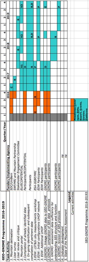
Planning, including specific milestones and deliverables
The planning table below indicates the major tasks of GEO-GNOME, their milestones and their general
time frame. GEO-GNOME deliverables include
1) Access to data
• A data discovery strategy via the formation and promulgation to the mountain community of
metadata to allow discovery and support cataloging of mountain relevant data
• A data access strategy (including a mountain portal) that supports examination and distribution of
data
2) Data themselves
• Global coverages (in grid and vector forms as needed) that portray the extent, elevational and
topographic nature of mountains globally.
• Coverages and datasets (global where possible, otherwise regional or local) related to observed
conditions and forecasts for drivers affecting mountains, such as climate change, land cover
change, population change, economic development, and managerial change.
• Coverages and datasets related to the benefits (ecosystem services and other resources) and
hazards related to mountains
• Coverages and datasets related to major socio-economic performance measures of mountain
social-ecological systems
3) Improved ability to foresee changes in services and socio-economic conditions based on
improved understanding of drivers and on the functioning of mountain social-ecological systems.• New datasets illuminating key issues (e.g relationship between in situ temperature and Land
Surface Tempearture (LST); poverty coverages)
• Clearer descriptions of data needed in policy, program and investment decisions.
• Theories, frameworks and models that describe mountain socio-ecological system (SES) function
and support scenario development and analysis
4) Improved capacity to observe and manage
observations and apply data to decision-making
• New observing efforts, both geographically
and thematically
• Frameworks that tag datasets with respect to
new policy frameworks (e.g. SDGs)
5) Periodic assessments (global, regional and local)
that response to SBAs, key variables associated with
SESs, and new concerns as embodied by Sustainable
Development Goals including those SDGs that
explicitly mention mountains:
• 6.6 By 2020, protect and restore water-related
ecosystems, including mountains, forests, wetlands,
rivers, aquifers and lakes;
• 15.1 By 2020, ensure the conservation,
restoration and sustainable use of terrestrial and inland
freshwater ecosystems and their services, in particular
forests, wetlands, mountains and drylands, in line with
obligations under international agreements
• 15.4 By 2030, ensure the conservation of
mountain ecosystems, including their biodiversity, in
order to enhance their capacity to provide benefits that
are essential for sustainable development;
as well as other SDGs relevant to mountains regions,
including but not limited to:
• 1.4 By 2030, ensure that all men and women,
in particular the poor and the vulnerable, have equal
rights to economic resources, as well as access to basic
services, ownership and control over land and other
forms of property, inheritance, natural resources,
appropriate new technology and financial services,
including microfinance;
• 2.1 By 2030, end hunger and ensure access by
all people, in particular the poor and people in
vulnerable situations, including infants, to safe,
nutritious and sufficient food all year round;• 7.2 By 2030, increase substantially the share of renewable energy in the global energy mix;
• 8.3 Promote development-oriented policies that support productive activities, decent job creation,
entrepreneurship, creativity and innovation, and encourage the formalization and growth of micro-,
small- and medium-sized enterprises, including through access to financial services;
• 10.7 Facilitate orderly, safe, regular and responsible migration and mobility of people, including
through the implementation of planned and well-managed migration policies;
• 13.1 Strengthen resilience and adaptive capacity to climate-related hazards and natural disasters in
all countries;
• 16.1 Significantly reduce all forms of violence and related death rates everywhere.
As noted in Governance, the Implementation Coordination Committee provides a forum for
exchange, including monitoring and evaluations, among project participants. A formally
established Stakeholder Engagement Committee will provide periodic review by users and
stakeholders. The Implementation Coordination Committee will certainly report to GEO on a
timely basis and ask for GEO’s help in expanding GEO-GNOME’s resource base.
Data management & data policy
The vast range of pertinent data already identified and the much larger range of data yet to be identified
precludes any detailed exposition. There will be global GIS datasets clipped to the mountain extent but
also sub-global datasets from the scale of the nation to the individual research site, from the spatially
explicit to the highly generalized covering all aspects of social and biophysical features social-ecological
systems. While it is possible the GEO-GNOME data might feed into GEOSS Data CORE it is more likely
that GEO-GNOME will use these foundational data as a basis for a mountain-centric approach.
GEO-GNOME expect that most of the data stewards for these datasets will conform to GEOSS Data
Sharing Principles but such adherence cannot be assured a priori.
Given the high diversity of mountain data, the main challenges relate to data access. GEO-GNOME will
work simultaneously from the community up and from the technology down. GEO-GNOME will provide
venues in which the partners to work together to create an initial if simple community platform. At the
most basic level GEO-GNOME will determine how best to ensure that a search of world wide web using
typical queries (e.g. “data on landslide hazards in the tropical Andes”) will find webpages linked to
pertinent data. At the next level, GEO-GNOME will create community webpages that compile and
organize such links, providing users with a one stop directory of mountain data providers. While such
platforms are essentially “hand made” they provide a first basic functionality for the community of
practive.
At the same time, working down from the cutting edge of technology, GEO-GNOME will also investigate
how best to provide a clearing-house for data made available by data stewards. GEO-GNOME will
explore the use of existing portals (e.g. NextData, CUAHSI’s HydroClient) while awaiting the
development of more robust mechanisms arising from participants, especially ECOPOTENTIAL.
All data will be archived using the standards established by GEO/GEOSS, assuring interoperability of
data and results. All information will be transferred to the GEO Common Infrastructure (GCI) and will
contribute to a mountain part of the GEOSS database on ecosystems.• Risk assessment
The principal risks for GEO-GNOME are financial and arise from the network nature of the activity.
While considerable resources are available through ECOPOTENTIAL and NextData for Task 2, overall
project coordination, as well as Tasks 1 and 3 would benefit from additional resources. Tasks 4 and 5 will
also require resources but both are beyond the scope of this current workplan. Options for Tasks 4 and 5
will likely be come more apparent over the next several years.
As shown in the Annex, GEO-GNOME is a network activity; that is, while certain aspects (e.g. data
access) can be implemented by a handful of participants, much of GEO-GNOME’s work requires the
engagement of a great number of individuals and institutions spread across numerous GEO Member
Countries. It is a central tenet of GEO-GNOME organizers that the network’s status as an Initiative will
facilitate access to GEO-related funding in many of these countries, thereby adding to and aligning
current available resources. Indeed, one of the principal advantages of organizing GNOME under GEO is
exactly GEO’s utility as a venue for extending the organization begun by the organizers.
GEO-GNOME requires a small but non-zero level of support for network coordination. MRI and CNR
have committed resources to coordination and are currently working with the Belmont Forum to access
resources attributed to the observatory-oriented thrust associated with the Forum’s recent call, Mountains
as Sentinels of Change.
MRI is currently negotiating with the Swiss Development and Cooperation Agency for a one-time
reallocation of funds to complete Task 1, with a promise of significant collaboration with the US
Geological Survey’s Land Science Program.
The Focused Campaigns of Task 3 have already begun using the resources of the participants listed in the
Annex. The High Elevation Climate Campaign will definitely require additional resources if it is to
achieve the global coverage of UHOPs envisaged. GEO-GNOME expects to use the good offices and
venues provided by GEO to obtain funding from individual Member State and other Participating
Organizations. Similarly the Global Network of Mountain Observatories, the network of in situ
observations as well as the nexus for understanding the structure and function of mountain social-
ecological systems, is already operating on the basis of GNOMO participants’ funding. Accelerating
GNOMO’s progress and the incorporation of GNOMO’s in situ data into a global data portal will require
additional resources for GNOMO participants. Such resources will most likely not come from a single
source, but rather be garnered by individual participants from national sources on the basis of GNOMO’s
inclusion within GEO-GNOME. Once again the good offices and venues provided by GEO will help in
this on-going resource mobilization effort.
Other risks to GEO-GNOME include dispersion of effort, differing commitments to open data and
mismatch with policy needs. Dispersion of effort, i.e., an inability to marshal different project components
to achieve the overall goal, is endemic to cooperative network projects which by the absence of
centralized funding means that participants must rely on frequent communication and consultation to stay
on track (see Governance).
While Data Sharing may represent an ideal, GEO-GNOME will certainly encounter instances where data
stewards do not agree to make their data available to all for free. GEO-GNOME will develop the means
as part of its data portal efforts to allow potential users to contact data stewards in order to gain access tothe data without necessarily making the data public. Finally it is possible that the data that are readily available for mountain regions are simply not congruent with the needs of policy and decision makers. Experience to date indicates that this is certainly true in some cases, but also that useful data do exist. GEO-GNOME will be particularly attentive in its outreach to policy and decision makers to identify key unmet data requirements and to recycle that information back to the mountain research community, especially the funding agencies. Management and governance GEO-GNOME will have a Implementation Coordination Committee that consists of 1) the originators of the project: an MRI and CNR representative and 2) anyone whom the current members of the ICC deem as taking a leading role in the implementation of any of the five tasks. So for instance if Roger Sayre from USGS and Jürg Krauer from UniBe are taking an active role in Task 1, then they would be invited to join the ICC. Similarly, staff from NextData taking leading roles in developing the data portal would be invited to join the ICC. The goal of the ICC is to ensure that the network of people working on projects that feeds into GEO- GNOME is interactive - people communicate with each other, discuss outputs and so on – and that the activities are congruent with the project description. As new issues appear, the ICC will reevaluate the project description to determine if it needs to be altered. The ICC will require at least one meeting in the real world, in order to get to know each other, but after that the ICC could be run via web conferencing and websites on a 6 month schedule. GEO-GNOME will also include a Stakeholder Engagement Committee that consists of representatives from different communities of practice related to mountains. Stakeholders would initially be self- nominated from among members of the Mountain Partnership as well as nominated by members of the ICC, with participation broadening over time as new users come to light. The goal of the SEC would be to provide the ICC and others working on projects feeding into GEO- GNOME guidance regarding the needs and desires of the communities of practices, from the international organizations like the FAO, to regional entities like the Alpine and Carpathian Conventions or ICIMOD, and even to local entities like national park managers and other land managers. It would be important for the SEC to meet with the ICC at least once (stakeholder engagement right from the start) but thereafter it too could probably be run virtually. The goal of this simple governance structure is to ensure that activities done under the umbrella of GEO- GNOME contribute materially to the goals and objectives of the project and that the goals and objectives of the project as themselves periodically reviewed for pertinence and feasibility. Committed resources The fundamental resource of GEO-GNOME is found in the long list of participants (see Annex 5). All of these participants have indicated their willingness to work toward their specific tasks. It is not possible to provide at this time a detailed breakdown of the financial values of these commitments to participate. While it is certainly true that some of the participants will in the end be unavailable to fulfill commitment
to contribution, most certainly will and will do so on the basis of their own funding.

Certain commitments can however be specified:

   •   MRI has included a 40% time position and chf 60’000 in program funds for GEO-GNOME in its
       next grant proposal to the Swiss National Science Foundation for the 2016-2019 period. These
       resources will provide the essential coordination needed for such a network project.
   •   The Swiss Development and Cooperation Agency has been requested to reallocate chf 43’500 in
       2016 and 2017 to ensure the completion of Task 1. The USGS Land Change Science Program has
       also indicated a strong interest in Task 1 and while the Program has not provided a financial
       amount, it has committed to active engagement in completing the task.
   •   ECOPOTENTIAL, a H2020 funded project which explores the use of Earth observations for the
       management of ecosystems, with mountain ecosystems as a specific sub-category, was conceived
       as a EU contribution to GEO. As such, ECOPOTENTIAL is expected to contribute significantly
       to Task 2 with the values of its contributions estimated at €1.5 million over the 2017-2019 period.
   •   The NextData project on CNR will likewise contribute to Task 2 with the values of its
       contributions estimated at €1.5 million over the 2017-2019 period.
   •   The targeted campaigns of Task 3 (EDW and GNOMO) are currently all funded by the
       participants themselves. A key next step for GEO-GNOME will be to use the good offices and
       venues of GEO to enlist more GEO Member and Participating Organization contributions to the
       campaigns.
ANNEXES
A. Technical Annex: High Elevation Climate Change
There are indications that climate warming is proceeding more rapidly at higher elevations (Pepin et
al. 2015). More rapid warming at higher elevations, labeled elevation dependent warming or EDW,
is analogous to the recognized phenomenon of accelerated Arctic warming and may lead to similar
environmental changes but with much greater human impacts due to the much higher population
densities in many mountain regions. Warming will in turn have impacts on the moisture content of
the atmosphere and can lead to precipitation changes that might also exhibit a dependence on
elevation (EDPC). There is less clarity regarding a global trend in what might be termed elevation
dependent precipitation change – the temporal change in the already complex relationship between
elevation and precipitation – as precipitation is strongly influenced not only by in situ energy
balance but also by local and large-scale circulation patterns (e.g. Luce et al. 2013).
GEO-GNOME’s campaign on high elevation climate change will address the needs noted by Pepin
et al. (2015) and Renwick (2014) through the creation of a Unified High Elevation Observing
Platform (UHOP).
New observational data are required to pursue three of the research needs identified in Pepin et al.
2015 with respect to EDW: elevational transects, process-oriented observations, remote sensing
validation. Expanding the network of high-elevation stations would also allow to create a basis for
the validation of regional climate models, this pursuing a further research need, and developing local
scenarios for impact and assessment studies.
There are similar needs to address uncertainties in the trend of high elevation precipitation change
(Renwick 2014).
This unified high elevation platform will consist of observational elevational transects in mountain
ranges representative of the global variation in latitude, elevational extent, continentality, and
orientation. On some mountain ranges it may be important for the transects to extend over the whole
range to include both windward/lee slope effects. The exact number and location of sites will be
decided later in consultation with national agencies and research organization but an indicative list
appears below and focuses on the highest elevations.
Tropical Andes: 4 transects (one each in Colombia, Ecuador, Peru and Bolivia)
Southern Andes: 2 transects (arid north, humid south including Chile and Argentina)
Western North America: 3 transects (Mediterranean southwest to Arctic north)
Africa: 8 transects (Bale and Simen mountains Rwenzori, Mt. Elgon, Mt. Kenya,
Kilimanjaro, Mt. Cameroon, Drakensberg)
Caucasus: 1 transect (Elbrus)
Alps: 3 transects (west to east)
Central Asia: 7 transects (one in Tadjikistan, two in Kyrgyzstan, three in Kazakhstan, one in
Russian Altai)
China: 6 transects (Qilian Mountains, Hengduan, Kunlun, Tibet)
Indonesia/Malaysia: 3 transects (on volcanos east to west along archipelago)Papau New Guinea: 1 transect
Hawaii: 1 transect (Mauna Loa)
Japan: 1 transect (Fuji)
Pakistan: 3 transects (Himalaya, Karakorum)
India: 3 transects (Himalaya east to west)
Nepal: 2 transects Himalaya east to west)
New Zealand: 2 transects (Southern Alps)
Each transect will consist of:
• Multiple sites (e.g. 5 -20) along a mesoscale transect as piloted by N. Pepin on Kilimanjaro
using inexpensive and low power sensors to measure limited variables (near surface air temperature,
relative humidity, barometric pressure and if possible land surfaces temperature and if possible
downward short wave radiation) with hourly data logging to enable detailed characterization of the
diurnal cycle.
• Two (on-grid/powered) weather stations with automatic data-logging with full energy
balance instrumentation in a tower configuration. Stations will also be equipped to measure
precipitation in both solid and liquid form as well as having snow pack/depth measurement with
corroborating data supplied by a webcam/time-lapse camera for verification of snow
presence/absence for data clearing/cleaning purposes.
These weather stations form the anchors and in some cases the extremities of the observational
transects. Instruments in the multiple sites along the transects will be calibrated against the weather
station data. In order to reduce costs, facilitate site selection, and encourage participation of relevant
meteorological agencies, these paired weather stations will enlist existing well-established mountain
weather stations.
These transects will not only provide the data needed to assess EDW and EDPC at the highest
elevations, but will also provide energy balance data to understand the mechanisms of EDW and
validation data needed to assess remotely sensed land surface temperature and precipitation products.
Finally they will provide data needed to assess the performance of climate simulation models.
It is recognized that the first stage of development of the global UHOP network will concentrate on
transects/areas already developed, through the agreement of protocols concerning data quality, calibration,
upgrading/maintenance of current instruments etc. This is important to ensure we obtain high quality
information about the changing environment at high elevations.
The following table lists the state of each proposed transect above and classifies it into one of three
categories. It is proposed to concentrate on supporting and expanding/upgrading where required transects
within category 1 as a priority, with longer-term goals to move on to categories 2 and 3.
1. Transect already in operation, either in terms of extremely high quality anchor sites, or a more
comprehensive network of stations covering the elevation gradient, or both. In most cases it would
be expected that at least 5-10 years of past data will already have been obtained for UHOPs in thisYou can also read