Climate Change Data and Risk Assessment Methodologies for the Caribbean - Prepared by: Tetra Tech, Inc.
←
→
Page content transcription
If your browser does not render page correctly, please read the page content below

Inter-American
                          Development Bank

                          Environmental
                          Safeguards Unit

                          TECHNICAL NOTE
                          No. IDB-TN-633

Climate Change Data and
Risk Assessment
Methodologies for the
Caribbean

Prepared by:
Tetra Tech, Inc.

                                April 2014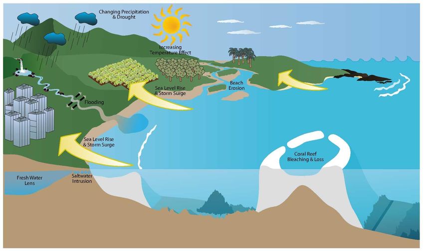
Climate Change Data and
    Risk Assessment
 Methodologies for the
       Caribbean

         Prepared by:
        Tetra Tech, Inc.

     Inter-American Development Bank
                  2014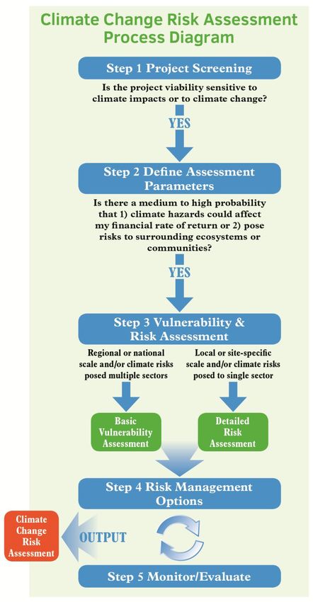
Cataloging-in-Publication data provided by the
Inter-American Development Bank
Felipe Herrera Library

Climate change data and risk assessment methodologies for the Caribbean / Prepared for Inter-American
Development Bank Environmental Safeguards Unit by Tetra Tech, Inc.
p. cm. — (IDB Technical Note ; 633)
Includes bibliographic references.
1. Climatic changes—Databases. 2. Climatic changes—Risk assessment—Caribbean Area. I. Tetra Tech,
Inc. II. Inter-American Development Bank. Environmental Safeguards Unit. III. Series.
IDB-TN-633

JEL Classification: Q5; Q54

Keywords: Climate Change, Risk Assessment, Climate Assessment, Caribbean

http://www.iadb.org

The opinions expressed in this publication are those of the authors and do not necessarily
reflect the views of the Inter-American Development Bank, its Board of Directors, or the
countries they represent.

The unauthorized commercial use of Bank documents is prohibited and may be punishable under
the Bank's policies and/or applicable laws.

Copyright © 2014 Inter-American Development Bank. All rights reserved; may be freely
reproduced for any non-commercial purpose.
This paper was prepared with the guidance and direction of Hilary Hoagland-Grey, Lead
Environmental Protection Specialist, Inter-American Development Bank (IDB) Environmental
Safeguards Unit (ESG). The technical note was written by Tetra Tech, Inc., led by Hope Herron,
with co-authors Bill Bohn, Dr. Sujoy Roy and Dr. Warren Evans.
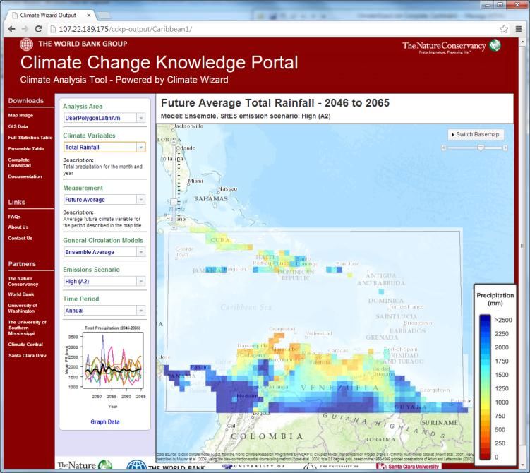
Table of Contents

                                        TABLE OF CONTENTS
1.0      Purpose and Approach........................................................................................... 1
2.0      Overarching Climate Change Risk Framework .................................................. 2
         2.1 Existing Risk Assessment Methodologies ............................................................................................ 5
         2.2 Proposed Climate Change Risk Assessment Methodology ............................................................ 7
         2.3 Climate Change Risk Assessment in the IDB Project Cycle ........................................................... 9
3.0      Climate Change Risk Assessment Methodology (Steps 1‒3) and Tools
         for the Caribbean ................................................................................................. 11
         3.1 Step 1: Screen the Project..................................................................................................................... 11
         3.2 Step 2: Define the Assessment Parameters ...................................................................................... 14
                3.2.1 Overview of Climate Data and Tools for the Caribbean ........................................... 15
                    3.2.1.1 Background on Climate Projections ...................................................................... 15
                    3.2.1.2 Temperature and Precipitation............................................................................... 16
                    3.2.1.3 Sea Level Rise.............................................................................................................. 23
                    3.2.1.4 Hurricane Frequency and Intensity ........................................................................ 26
                    3.2.1.5 Integrating Sea Level Rise and Storm Surge ........................................................ 29
                    3.2.1.6 Decision Making using Uncertain Climate Projections ..................................... 32
         3.3 Step 3: Vulnerability and Risk Assessment ........................................................................................ 33
                3.3.1 Background on Climate Change Vulnerability and Risk Assessment ....................... 33
                3.3.2 Determining the Type of Assessment Needed ............................................................. 34
                3.3.3 Step 3a: Basic Vulnerability Assessment ......................................................................... 36
                    3.3.3.1 Exposure ...................................................................................................................... 36
                    3.3.3.2 Sensitivity ..................................................................................................................... 39
                    3.3.3.3 Adaptive Capacity ...................................................................................................... 41
                    3.3.3.4 Understanding Basic Vulnerability Assessment Results .................................... 41
                3.3.4 Step 3b: Detailed Risk Assessment .................................................................................. 41
                    3.3.4.1 Hazard Assessment ................................................................................................... 42
                    3.3.4.2 Hydrologic Models (focused on estimated of flow volumes) .......................... 43
                    3.3.4.3 Hydraulic Models (focused on estimation of flood elevation) ........................ 44
                    3.3.4.4 Erosion Models ........................................................................................................... 44
                    3.3.4.5 Wave Height Models................................................................................................. 44
                    3.3.4.6 Run-up Models............................................................................................................ 45
                    3.3.4.7 Consequence Assessment ....................................................................................... 45
4.0      Conclusions ........................................................................................................... 47
5.0      Recommendations for Next Steps ..................................................................... 48
6.0      References ............................................................................................................. 50
Annex 1: Tools and Resources ....................................................................................... 53

                                                                             i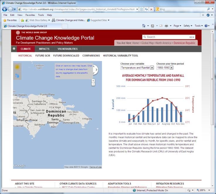
Table of Contents
TABLES
Table 2.1 Climate Change Risk Assessment Methodology Steps ......................................................... 6
Table 3.1 Proposed Classification Filter for Climate Risk Project Screening ....................................... 13
Table 3.2 Proposed Ranking Criteria to Determine Type of Vulnerability Assessment Needed ............ 36
FIGURES
Figure 2-1. Illustrative climate risks to Caribbean nations. ................................................................ 3
Figure 2-2. Climate Change risk assessment process diagram. .......................................................... 8
Figure 3-1. Historical temperature and precipitation for the Dominican Republic from the World
Bank’s CCKP at . ......................................................... 17
Figure 3-2. Projected mean temperature for the Dominican Republic for 2046‒2065 from the
World Bank’s CCKP at . The plot on the right shows
projections for 9 different GCMs. .............................................................................. 18
Figure 3-3. Projected mean precipitation for the Dominican Republic for 2046‒2065 from the
World Bank’s CCKP at . The plot on the right shows
projections for 9 different GCMs. .............................................................................. 19
Figure 3-4. Projected precipitation for the Caribbean region for 2046‒2065 using CMIP3 data and
a mapping tool called ClimateWizard that has been customized for the World Bank’s
CCKP at . ................................................................... 20
Figure 3-5. Projected precipitation for the Caribbean region for the 20th and 21st century from
the CMIP5 data. summary plot obtained from . ................... 21
Figure 3-6. Projected changes in June, July, and August (JJA) precipitation through a GCM (left)
and through an RCM (right). The lower panel is for dynamic downscaling for North
America (including parts of the Western Caribbean region) for the mid-21st century.
These results are based on a specific pairing of a GCM and an RCM. The GCM used is
CCSM, the RCM used is MM5I. (Source: http://www.narccap.ucar.edu/results/tmsl-
results.html). Although the results do not match, both indicate a decrease in
precipitation in the portion of Caribbean that falls in the model domain. ........................ 22
Figure 3-7. Projected changes in precipitation through a Caribbean-specific RCM (PRECIS). This
Web interface can be used to develop maps for specific variables for different time
periods, and can also be used to download numerical data. ........................................... 23
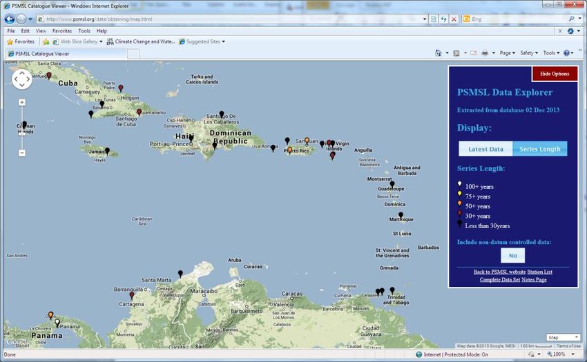
Figure 3-8. Active sea level gauges in the Caribbean, as reported by the PSMSL. The colors of the
symbols indicate the length of record, and most are 30 years or less. ............................ 24
Figure 3-9. Sea level (monthly and annual mean) for a gauge in Cristobal (Panama). This is one of
the longest periods of record in the Caribbean region in the PSMSL database. ................ 25
Figure 3-10. Sea level rise from 1950 to 2100 based on a semi-empirical model (Vermeer and
Rahmstorf 2009) and three emission scenarios (A2, B1, and A1FI). AR4 refers to
projections made in the IPCC 2007 report. The increase seen over the historical
period is expected to accelerate significantly based on this model. ................................. 26
Figure 3-11. Projection of sea level rise from 2000 to 2100, along with upper and lower
uncertainty bounds, based on an evaluation of the literature and alternative modeling
methods (National Academy of Sciences 2012). The models employed for this
composite projection are in addition to the Vermeer and Rahmstorf (2009)
projections shown in Figure 3-10................................................................................ 26
ii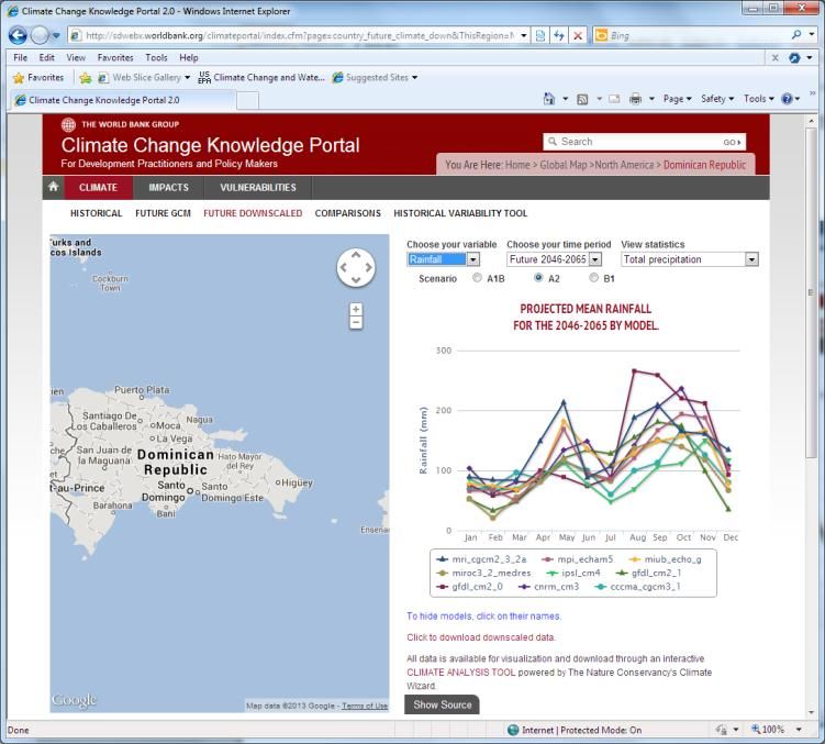
Table of Contents

Figure 3-12. Hurricanes from 1851 to 2010, aggregated over 5 years in the Eastern and Western
           Caribbean. (category 3‒5: purple; category 1‒2: red; tropical storms: blue).
           (Source: http://stormcarib.com/climatology/) ................................................................ 27
Figure 3-13. Modeled and observed hurricanes from 1980-2012. ................................................... 28
Figure 3-14a. Storm surge computed by the TAOS model for the Dominican Republic .................... 30
Figure 3-14b. Storm surge computed by the TAOS model for Jamaica (Source: CDMP project). ........ 31
Figure 3-15. Inundated areas for Kingston, Jamaica, for conditions representing ~4 meters higher
           water level than mean sea level (1.2-meter mean sea level rise due to climate change,
           and 2.5-meter storm surge, estimated using the TAOS model for this region). ................ 32
Figure 3-16. Risk assessment methodologies (Source: Jones and Preston 2011)................................. 34
Figure 3-17. Vulnerability and risk assessment needs compared to methodologies (Source: NOAA
           2008)....................................................................................................................... 35
Figure 3-18. Risk assessment components.................................................................................... 42
Figure 3-19. Scenario-Based (Source: NOAA, 2008). ..................................................................... 42
Figure 3-20. Flood damage function. ............................................................................................ 46

                                                                   iii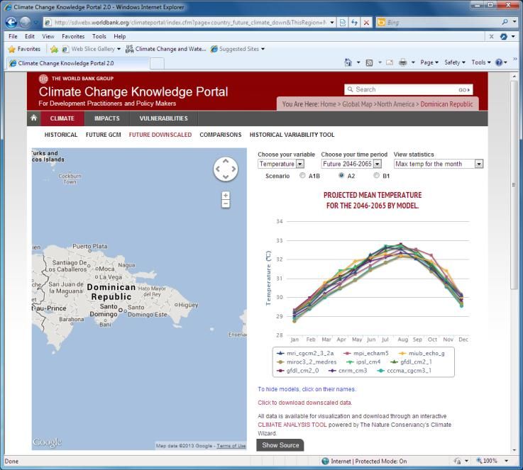
Acronyms and Abbreviations

             ACRONYMS AND ABBREVIATIONS
ASICDOM      Asociación de Ingeniería y Consultoría Dominicana
AOGCM        Atmosphere-ocean General Circulation Model
CAPRA        Central America Probabilistic Risk Assessment
CARDIN       Caribbean Disaster Information Network
CCKP         Climate Change Knowledge Portal
CCORAL       Caribbean Climate Online Risk and Adaptation TooL
CCRIF        Caribbean Catastrophe Risk Insurance Facility
CDMP         Caribbean Disaster Mitigation Project
CEDRIG       Climate, Environment, and Disaster Risk Reduction Integration Guidance
CIMH         Caribbean Institute for Meteorology and Hydrology
CMIP         Coupled Model Intercomparison Project
CMIP3        Coupled Model Intercomparison Project Phase 3
CMIP5        Coupled Model Intercomparison Project Phase 5
DPC          Direction de la Protection Civile
ESG          Environmental Safeguards Unit
GCM          Global Climate Model
GIS          Geographic Information System
GIZ          Deutsche Gesellschaft für Internationale Zusammenarbeit
GLOSS        Global Sea Level Observing System
HAZUS        Hazards U.S.
IDB          Inter-American Development Bank
IFC          International Finance Corporation
IPCC         Intergovernmental Panel on Climate Change
LiDAR        Light Detection and Ranging
MET          Meteorological
NARCCAP      North American Regional Climate Change Assessment Program
NOAA         U.S. National Oceanic and Atmospheric Administration
OECD         Organisation for Economic Cooperation and Development
PRECIS       Providing Regional Climates for Impacts Studies
PSMSL        Permanent Service for Mean Sea Level
RCM          Regional Climate Model
SLOSH        Sea, Lake, and Overland Surge Hurricane
SRTM         Shuttle Radar Topography Mission
SST          Sea Surface Temperatures
UNEP         United Nations Environment Programme
UNESCO/IOC   United Nations Educational, Scientific and Cultural Organization/Intergovernmental
             Oceanographic Commission
UNISDR       United Nations Office of Disaster Reduction
USAID        U.S. Agency for International Development
WCRP         World Climate Research Programme

                                              iv
1.0 Purpose and Approach

1.0 Purpose and Approach
The Inter-American Development Bank (IDB) Environmental Safeguards Unit (ESG) initiated this study
to address the need to better understand how to assess and address climate change related risks in IDB-
funded projects. The Caribbean region is uniquely sensitive to natural hazards such as hurricanes,
extreme precipitation events, and coastal storm surges due to the relatively small size and low
elevations of the island nations that make up the region. Climate change is expected to exacerbate the
threat of natural hazards. As a result of climate change, average temperatures and sea levels are rising,
precipitation patterns might change, and hurricanes could intensify. Many of these changes are already
occurring, and are projected to become more severe in the future.

The IDB acknowledges in its Safeguard Policies1 that, “The risks and impacts identification process will
consider the emissions of greenhouse gases, the relevant risks associated with a changing climate and the
adaptation opportunities.” Climate change could adversely affect the intended outcomes of development
operations, as well as impact the economic and financial rates of return of IDB investments. Effective
risk assessment is critical to guide IDB’s development financing and (1) to assist its borrowers in
reducing risks from climate change and (2) to support the attainment of their social, environmental, and
economic development goals.

The purpose of this paper is to: (1) propose a step-wise process to assess climate change risks to IDB
projects and (2) identify tools and methodologies to support the risk assessment process specific to the
Caribbean region. The pilot risk assessment process focuses on the direct and indirect risks to projects
from three climate-induced hazards: sea level rise, hurricanes (including storm surge), and flooding (both
coastal and riverine) because these hazards are considered to pose the greatest threat to the Caribbean
region. Further consideration was given to the types of projects most vulnerable to climate risk,
including infrastructure projects; projects that involve investments in, or rely substantially on, natural
resources (such as water and agriculture); and projects that rely on other infrastructure (such as
national transportation infrastructure for tourism).

Significant work has been undertaken in recent years to understand climate variability and change and
related risks in the Caribbean, including that conducted under the Caribbean Community Climate
Change Centre and the IDB-World Bank Pilot Program for Climate Resilience in the Caribbean. This
paper builds on these efforts by identifying and summarizing information that is most salient to
evaluating site-specific climate risks. It is important to note that this paper relied on existing information
and did not involve field research.

This paper is organized into the following sections:
      Section 2: Overarching Climate Risk Framework

      Section 3: Climate Risk Assessment Methodology (Steps 1‒3) and Tools for the Caribbean

      Section 4: Conclusions

      Section 5: Recommendations for Next Steps

      Section 6: References

1
    IADB Environmental and Social Safeguards – http://publications.iadb.org/handle/11319/2580

                                                        1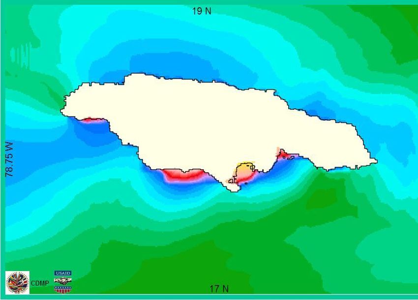
2.0 Overarching Climate Change Risk
                                                                                                       Framework

Of note, the tools and resources identified in this paper are included along with their respective
hyperlinks in Annex 1. A fact sheet has also been developed that summarizes the climate risk assessment
approach and recommended tools presented in this paper. The objective of the fact sheet is to help
project proponents better understand and conduct the recommended climate risk assessment. Given
the vast amount of relevant information available on the Internet, to the extent feasible, links to other
documents/data resources are provided as hyperlinks in the electronic version of this file.

The intended audience of this paper is individuals who may need to develop climate risk assessments for
specific public or private sector investments and those who need to evaluate/review such risk
assessments performed in support of environmental impact documentation.

2.0 Overarching Climate Change Risk
    Framework
The Caribbean includes relatively small island nations that typically have low elevations and high
population densities located in the coastal zone. These factors make the Caribbean region particularly
susceptible to natural hazards, which are anticipated to pose a greater risk under future climate
scenarios. The Caribbean is also characterized by its heavy dependence on tourism and agriculture; both
of these sectors are highly vulnerable to climate change risk. Underscoring this vulnerability, from 1975
to 2002 natural disasters caused $3.2 billion in physical losses in the region—more than half the level of
annual loan commitments by the IDB (IDB 2004). However, the projected losses to the region under
future climate change are anticipated to be much greater. Bueno et al. (2008) found that if no adaptation
measures are implemented to mitigate climate risk, damages in the region could total $22 billion annually
by 2050 and $46 billion by 2100.2

Climate change will thus exacerbate the current financial risks to IDB-funded projects in the Caribbean,
with the potential to damage infrastructure and cause long- and short-term disruptions to supply chains,
services (e.g., water supply), and markets. Impacts to natural resources, such as coral reefs and beaches,
will adversely affect private sector investments in the tourism sector. Both directly and indirectly,
climate impacts could adversely affect the financial, economic, environmental, and social performance of
current and future IDB investments in the region.3 Figure 2-1 illustrates some of the primary climate
risks to Caribbean nations.

2
  The study considered increased hurricane damages, loss of tourism revenue, and infrastructure damages on 24
island nations in the Caribbean. Refer to  for additional
information.
3
  For additional information related to climate science and projected climate change impacts, refer to the IPCC
Assessment Reports: ,
as well IDB Technical Notes developed on the topic (Iqbal and Suding, 2011; Simpson et al., 2011).

                                                        2
3
Figure 2-1. Illustrative climate risks to Caribbean nations.
2.0 Overarching Climate Change Risk
Framework2.0 Overarching Climate Change Risk
Framework
Climate change can affect projects in many different ways. In the box below, a general impact chain is
presented using the disaster risk concept.4 In this view, two groups of climate change manifestations are
distinguished, those which affect rapid onset natural hazards and those which impact slow onset
natural hazards.5
According to this, climate change may increase rapid onset disasters by greater climate variability, i.e.
increase in the frequency and/or severity of natural hazards such as intense storms, heavy rainfall, long
and deep drought periods etc. and the respective impacts. Climate change also may cause long term
slow onset change in the project region such as changes in mean average, maximum and minimum
temperatures, and changes in precipitation amount, onset, duration, and geographic distribution. These
changes contribute to follow-on impacts such as sea level rise, changes in water availability and its timing,
and changes in crop yields.
Climate Change
Affects rapid onset natural hazards and slow onset natural hazards
Depending on exposure of project and area of influence
and vulnerability / Resilience of project, area and society
Disaster Risks are high, moderate or low
for project itself (scenario Type 1) and/or
for human life, property, environment (scenario Type 2)
Disaster and Climate Change Risk Management
reduces exposure, mitigates vulnerability and/or makes provisions in order to
achieve an acceptable level of risk.
From: IDB draft guidance notes
Depending on intensity of the change, exposure of project and area of influence and the vulnerability or
resilience of the project, the area and the society, the impacts of the naturals hazards may be extreme,
significant, moderate or low. With respect to the objects of the impact a distinction is made between
the project itself (scenario type 1) and the environing systems (scenario type 2). In the text box below
further sub- distinctions of the scenarios in the impact chain are made and examples given.
4
IDB’s Disaster Risk Management Policy (OP 704) has been adopted as the framework for incorporating climate
change risks in the project cycle. A rather wide definitions of hazards is used including the slow changes.
5
In an IDB options paper from 2011(Iqbal and Suding 2011), these groups are called Category A and Category B
climate change manifestations, available at:
http://idbdocs.iadb.org/wsdocs/getdocument.aspx?docnum=37671112>. In IDB, this classification has been
developed further in the course of incorporating climate change risk with disaster risk assessment and
management in the project cycle.
42.0 Overarching Climate Change Risk
Framework
Integrated Classification of Disaster and Climate Change Risks to IDB Development
Projects
Type 1 Disaster Risk Scenario: The project itself could be adversely impacted by natural hazards.
This may occur in two forms:
1. Direct impact of a hazard on assets and operations, including damage and destruction of assets,
and modification or shutdown of operations, e.g., developments located in coastal zones of the
Caribbean are likely to be affected by hurricanes, tropical storms and coastal flooding due to storm
surges;
2. Direct impact of a hazard on area of influence, from where resources for the project originate with
economic repercussions on project; e.g., an irrigation system that relies on water runoff from glaciers
that are shrinking, or an agricultural processing project that relies on produce from a region where
suppliers are switching to other crops that are more suited to changing climatic conditions.
Type 2 Disaster Risk Scenario: The operation has a potential to exacerbate hazard risk to human
life, property, the environment or the operation itself. This may occur in two ways:
1. The natural hazard poses risks through the project for people and the environment in the area of
influence (knock-on effects from damages or changes in operation in the project). Examples include:
damage to a dam results in its failure to retain water mass; spillways of hydropower projects are not
sufficient to regulate the water flow in case of extreme hydrological events and could increase risks of
overflow and downstream flooding; a damaged pipeline or storage tank leaks toxic substance into the
environment; a loose part of a damaged structure in motion (on slope or in the sea) destroys adjacent
structures; etc.
2. The project reduces resilience to natural hazards of people and the environment in the area of
influence: construction, implementation and operation activities of a project may increase the
vulnerability. Examples include: removal of vegetation by a project in mountainous terrain could
weaken the soil stability and initiate a landslide in heavy precipitation events or could exacerbate
erosion, leading to flooding; removal of vegetation or earth for a coastal project may exacerbate
coastal erosion, which reduces the resilience of the coast and its infrastructure against storm surges;
obstruction of floodplains by project works could lead to blockage of drainage flows and diversion of
floods, exacerbating the impact of inland floods.
From: IDB Safeguards Policy Filter project screening tool)
2.1 Existing Risk Assessment Methodologies
This section identifies key risk assessment methodologies that have been developed at the international
and regional level to provide a general climate risk framework. This list is not meant to be exhaustive;
rather, it reflects the most relevant and internationally respected guidance documents developed to
date. This paper discusses the following key guidance documents:
Caribbean Risk Management Guidelines for Climate Change Adaptation Decision Making (Caribbean
Community Secretariat 2008)
52.0 Overarching Climate Change Risk
Framework
Shaping Climate-Resilient Development: A Framework for Decision-making (Economics and Climate
Adaptation Working Group 2009)
Climate Risk and Business (IFC 2010)
Climate Proofing for Development: Adapting to Climate Change, Reducing Risk (Deutsche Gesellschaft
für Internationale Zusammenarbeit [GIZ] 2011)
Climate, Environment, and Disaster Risk Reduction Integration Guidance (Swiss Agency for
Development and Cooperation 2010)
Although it is anticipated that the World Bank and IDB Pilot Program for Climate Resilience in the
Caribbean will also yield valuable lessons learned regarding risk assessment methodology, the program
has only recently begun; therefore, limited data on results are available.
Each of the guidance documents listed above identifies a framework for evaluating climate change risk
that includes several steps and guiding principles. The specific steps identified in each guidance document
are identified in Table 2.1. The variance reflects the different levels of analysis (e.g., institutional, national,
local) and interventions (e.g., development aid, national adaptation planning, private sector investment)
that the individual guidance document was developed to target. Table 2.1 identifies the target audience
for the guidance documents.
Table 2.1 Climate Change Risk Assessment Methodology Steps
Summary of Climate Change Risk Assessment Methodology Audience and Steps
Climate, Environment,
Caribbean Risk Shaping Climate and Disaster Risk
Management Resilient Climate Risk and Climate Proofing Reduction Integration
Guidelines Development Business for Development Guidance
Target Decision Makers in
Development Banks Private Sector Development Banks Development Banks
Audience Caribbean Region
Step Identified in Subject Document
Comprehensive
Identify Problem/
Step 1 Get Started Approach and Prepare Assess Risks
Objectives
Objective
Analyze the Climate Prioritize Hazards
Establish Decision- Identify Adaptation and
Step 2 Variability or Climate and Locations Analyze
making Criteria Risk Reduction Options
Change Hazard
Recognize
Identify Options for Select Adaptation and
Step 3 Estimate the Risk Uncertainty of Assess Risk
Action Risk Reduction Options
Climate Change
Identify Cost-
Define Monitoring and
Step 4 Evaluate the Risk Effective Priority Identify Options Integrate
Evaluation Indicators
Measures
Focus on Addressing
Adapt, Control Risk
Step 5 Development Appraise Options Prepare
and Financing
Bottlenecks
Encourage Funding
Implement and
Step 6 from International Make Decision Analyze
Monitor
Community
Mobilize Implement
Step 7
Stakeholders Decision
Step 8 Monitor
Note: Not all methodologies have the same number of steps. For example, the Climate, Environment, and Disaster Risk Reduction Integration
Guidance (CEDRIG) identifies 4 steps; thus, cells 5‒8 are blank. See text above identifying the organizations that have prepared these risk
assessment documents.
62.0 Overarching Climate Change Risk
Framework
It is useful to consider the different climate risk methodologies and audiences of the available guidance
documents to develop a targeted step-wise methodology that will be specific to the IDB private sector
portfolio in the Caribbean. In general, each of the methodologies recommend the following steps: (1)
undergo an initial screening to identify climate risk and define parameters, (2) conduct a risk assessment,
(3) identify and implement adaptation options, and (4) monitor and evaluate the results. The importance
of stakeholder engagement to better understand site-specific concerns and more effectively identify and
implement adaptation options is also identified as a cross-cutting issue.
The International Finance Corporation’s (IFC’s) Climate Risk and Business methodology is the most
relevant guidance for this paper, given the multilateral and private sector focus. In the compendium
documents, the IFC methodology is further tailored to sector-specific climate risk assessments; for
example, it considers the project’s exposure, sensitivity, and adaptive capacity as part of the vulnerability
assessment. (IFC’s pilot projects will be further discussed in later sections.) With the exception of the
IFC pilot studies, an overarching finding of this literature review is that available methodologies are very
general and lack guidance on the specific steps, models, and tools that are needed to conduct a project-
specific risk assessment. IFC has an ongoing program to prepare sector-specific guidance; however, this
guidance will not be completed until late 2014.
2.2 Proposed Climate Change Risk Assessment Methodology
Based on an evaluation of existing work, and an understanding of IDB’s current needs and policies, the
following climate risk assessment methodology steps have been developed for use by IDB clients;
expected to provide the most robust, yet flexible framework for assessing climate change risk:
Step 1: Screen the project for climate change risks to determine whether further climate change
related analysis is necessary.6
Step 2: Define the assessment parameters. This includes defining the site and planning horizons
and identifying and gathering relevant data to better understand what type of vulnerability
assessment will be conducted.
Step 3: Conduct a vulnerability and risk assessment to identify how susceptible the project is to
climate change hazards (such as sea level rise, hurricanes, flooding, and drought). Determine
whether a basic or detailed risk assessment is needed.
Step 4: Identify adaptation options to mitigate the risk.
Step 5: Implement adaptation options and monitor and evaluate their effectiveness. Make
adjustments based on new data.
The approach is structured as a tiered process, and provides the flexibility to stop after project
screening (Step 1) if the project viability is not sensitive to climate change, and to choose whether a
basic vulnerability assessment or more complex risk assessment is necessary for the proposed project
(Step 3).
6
Please note that this screening is different from the integrated IDB project screening using the safeguards policy
and classification filters and executed by IDB project team.
72.0 Overarching Climate Change Risk
Framework
Figure 2-2. Climate Change risk assessment process diagram.
82.0 Overarching Climate Change Risk
Framework
2.3 Climate Change Risk Assessment in the IDB Project
Cycle
Climate-related risks to IDB-financed projects should be addressed per the Environmental and Social
Safeguards Compliance Policy (Directives A.3, A.6, and B.4) and the Disaster Risk Management
Safeguard and Policy (Guidelines 1.7 and 1.8 and Directive A-2).
The proposed climate risk assessment methodology is intended for use by the IDB and their borrowers
to help assess and reduce climate-related risks to acceptable levels. The project proponents will conduct
the climate risk assessment in the framework of the disaster risk assessment to meet the borrowing
requirements.
As envisioned in this paper, the climate risk assessment will be implemented in the project preparation
stage, and the findings carried throughout the IDB project cycle phases and compliance requirements.
This approach is supported through the Organization for Economic Cooperation and Development
(OECD, 2009) recommendations of using a “climate lens” as a comprehensive framework for
mainstreaming adaptation into policy and planning processes, whereby analysis of climate change risks
and interventions are mainstreamed throughout the life of the project or program.7
Since IDB has adopted the integration of climate change risk assessment in the disaster risk management
procedures, the present
Methodology has been developed so that it could be directly incorporated into both the Environmental
and Social Safeguards Compliance Policy requirements (OP-703) and Disaster Risk Management Policy
(OP 7-4) requirements. For example, the climate risk assessment could be inserted directly as a section
in a Disaster Risk Management Plan or included as an appendix to an Environmental Impact Assessment,
and referred to in the Disaster (and Climate Change) Risk Management Summary.
IDB asks the borrowers of projects which show high or moderate disaster risks to prepare a disaster
(and climate change) risk management summary. The content of this summary is presented in text box
below. The specific climate change risks will be addressed in section 3 of this summary.
The distinction between impacts on the projects (type 1 scenario) and the human life, property and
environment around it (type 2 scenario) made in section 2.0 is important, since it allocates the
responsibilities in the further project risk management process. Whereas the risks for the project itself
is a matter particularly important of the credit risk management, the risk for human life, property and
environment is rather a matter of the environmental and social safeguards process.
7
A climate lens is further defined as “an analytical tool to examine a strategy, policy, plan, programme or
regulation. The application of such a climate lens at the national or sectoral level involves examining: (i) the extent
to which a measure – be it a strategy, policy, plan or programme – under consideration could be vulnerable to risks
arising from climate variability and change; (ii) the extent to which climate change risks have been taken into
consideration in the course of the formulation of this measure; (iii) the extent to which it could increase
vulnerability, leading to maladaptation or, conversely, miss important opportunities arising from climate change;
and (iv) for pre-existing strategies, policies, plans and programmes which are being revised, what amendments
might be warranted in order to address climate risks and opportunities.” The full document is available at
.
92.0 Overarching Climate Change Risk
Framework
Outline of Disaster Risk Assessment Summary
1. Summary of initial disaster risk profile of project; identification of pertaining (high or
moderate) natural hazards; exclusion of low risk hazards
2. Disaster Risk Assessment (DRA) for relevant rapid onset hazards (conventional analysis,
without considering climate change;
2.1. Specification of rapid onset natural hazards (type, intensity, frequency) for the particular
project area (exposure);
2.2. Potential impact of event (at likely recurrence level) on project and area of influence
during implementation and operation of project (scenario type 1), including exacerbated
impacts when project is implemented and operating, on human life and integrity,
property, social systems and environment (scenario type 2)for given vulnerability levels
and coping capacities;
2.3. Risk reduction options for identified project risks, using industry standards and standard
methodology (without considering potential additional impacts exerted climate change),
alternatives;
3. Revision of Disaster Risk Assessment, addressing Climate Change
3.1. Modification of hazards, vulnerability and potential impacts by climate change (mainly for
hydro-meteorological events)
3.1.1. Frequency and intensity of rapid onset hazards modified by Climate Change,
3.1.2. New Climate Change related risks; slow onset hazards and shifting of
averages / patterns:
3.2. Risk reduction options that also deal with additional risks posed by climate change;
decision making under (compounded) uncertainty (probability given by historical trends;
additional uncertainty from anticipated climate change); project design at an acceptable
level of natural hazard risks
4. Disaster Risk Management Plan
4.1. Disaster risk reduction (siting, investment choice, engineering)
4.2. Disaster risk preparedness (e.g., contingency planning) and response
4.3. Financial protection (transfer, retention)
From: IDB draft guidance note
Stakeholder involvement is considered cross-cutting across the project cycle. It is therefore
recommended that climate change issues be incorporated in all stakeholder engagement activities per
OP-703 of the Environment and Safeguards Compliance Policy.
103.0 Climate Change Risk Assessment
Methodology (Steps 1‒3) and Tools for the
Caribbean
3.0 Climate Change Risk Assessment
Methodology (Steps 1‒3) and Tools for
the Caribbean
This section will focus on steps 1 to 3 of the proposed methodology and will identify the state of knowledge
specific to the Caribbean as well as the tools and data sets available for performing these steps.8
3.1 Step 1: Screen the Project
This step requires screening the project for vulnerability to climate hazards based on the type of project
and its location/exposure. The overarching question is whether the project viability is sensitive to climate
change impacts, including increases in climate-related rapid onset natural hazards or to slow onset
gradual, long-term changes of climate variables The location will determine exposure and the likelihood of
climate hazard occurrence and severity. For example, screening a coastal infrastructure project will
consider increased inundation risk based on a location’s elevation compared to future sea level plus storm
surge. Projects that rely on critical supply chains should consider the location of those manufacturing or
production centers.
Because a great deal of projected climate change information is readily available, often through relatively
easy-to-use Web interfaces (identified below), information on key future conditions at a specific location
can be obtained with minimal effort and user expertise. This stage of the evaluation should also consider
the risk to the project under the current range of climate variability and extremes as estimated through
current observations. Current variability may or may not be related to climate change, but the specific
cause is not as important as the need to understand the project response.
The following climate change manifestations must be considered in the project screening, all of which
are supported by observational and modeling studies:
Increased temperature, including extremes
More uncertain precipitation and greater extremes in precipitation
Droughts, and reduction in water availability
Increase in mean sea level
Increased risk of coastal and riverine flooding
Increased hurricane intensity, including extreme wind speeds
Loss of coral reef area
Erosion of beaches
Given the above impacts, the screening should include (but is not limited to) the following first
pragmatic questions:
How far is the project from the shoreline? Proximity to the coast almost always increases potential
risks due to coastal flooding and hurricanes.
8
Additional guidance for steps 4 and 5 is forthcoming.3.1 Step 1: Screen the Project
What is the project elevation? Projects at elevations substantially higher than sea level and storm
surge estimates are expected to be at lower risk from ocean-related impacts.
How far is the project from an inland water body? Inland water bodies can be subject to flooding
from extreme precipitation events, and proximity to streams might be a potential risk.
How much fresh water will the project need to operate? Water resources are expected to become
more constrained and dependence on large water withdrawals is a potential risk.
What natural resources does the project’s success depend on (beaches, coral reefs, agricultural
products)? Natural resources (including agricultural resources) can be an indirect component of a
project’s success, and adverse impacts to these resources might affect the success of the related
project.
Where are critical supply chain locations? Projects could depend on products or services in other parts
of the country or region. Understanding the potential exposure of the supply chain to climate impacts is
also important. Answering the questions above for all critical supply chain locations and associated
activities will help determine exposure to climate impacts.
Climate change impacts, such as changes in precipitation or increased intensity of hurricanes, could
impact a project’s integrity and result in negative effects to the surrounding environment or
community. For example, increased hurricane intensity could lead to increased storm surge to an oil
pipeline project or other coastal infrastructure. If the storm surge is higher than the pipeline was
designed to withstand, the pipeline could fail, causing a spill which could in turn affect local
communities and ecosystems.
These questions do not have simple answers, but the assumptions that are used to justify a project must
be evaluated in light of the climate change impacts identified above. If the assumptions appear
questionable, then a more detailed assessment with more local, on-the-ground information and more
detailed modeling might be warranted. A detailed assessment almost always requires resources greater
than those required for a rapid assessment (often an order of magnitude or more). The project
screening, therefore, is a good first step before conducting a more detailed analysis.
There are several Web-based tools that could assist with the project screening, including the following:
The Caribbean Climate Online Risk and Adaptation TooL (CCORAL) is an online, open-source
tool that guides users through several steps, helping them identify whether climate change is
likely to influence their activity.
The World Bank’s Climate Change Knowledge Portal (CCKP) is an online tool for access to
global, regional, and country-level data related to climate change and development. The World
Bank’s CCKP includes environmental, disaster risk, and socio-economic data sets. (The portal
will be described in further detail in the next sections.)
The effects of climate change on the coast of Latin America and the Caribbean project database
is a geographic information system (GIS)-based database that contains information on coastal
dynamics in Latin America and the Caribbean, climate variability, coastal vulnerability and
exposure to climate change, the impact of climate change in the area, and an estimation of
predictable risks in the future.
123.1 Step 1: Screen the Project
A proposed classification filter for the project screening step is included below, with potential impacts
identified as low, moderate, or high risks (Table 3.1).
Table 3.1 Proposed Classification Filter for Climate Risk Project Screening
Proposed Classification Filter
Proposed Project
Screening Questions Additional Considerations Illustrative Classification
How far is the project Identify/assess current coastal floodplain. High risk: Project is in the current coastal floodplain
from the shoreline? Identify/assess projected future floodplain. (or < 3 miles from shore with minimal elevation).
Identify/assess potential impacts from Moderate risk: Project will be in the future floodplain
coastal flooding (includes risk from sea level in the near-term (20 years) (or < 5 miles from shore
rise, coastal erosion, and storm surge) and with minimal elevation).
anticipated time horizon. Low risk: Project is not in the coastal floodplain or
What is the project future floodplain (or is located > 5 miles from shore,
elevation? or elevated from flood risk).
How far is the project Identify/assess current riverine floodplain. High risk: Project is in the current riverine floodplain
from an inland water Identify/assess projected future floodplain. (or < 1 mile from bank with minimal elevation).
body? Identify/assess potential impacts from Moderate risk: Project will be in the future floodplain
riverine flooding (includes risk from sea level in the near-term (20 years) (or < 2 miles from shore
rise, coastal erosion, and storm surge) and with minimal elevation).
anticipated time horizon. Low risk: Project is not in the riverine floodplain or
future floodplain (or is located > 2 miles from shore).
How much fresh water Identify/assess all fresh water requirements High risk: Current or projected water availability is
will the project need to for the project, including any seasonal insufficient for project operations or a short-term,
operate? variability. temporary disruption of water resources would be
Identify/assess available fresh water detrimental to operations.
supplies, including any seasonal variability Moderate risk: Project relies on aquifer that is at-risk
and emergency water agreements/supplies. for salinization; or a shared water resource that has
If relying on municipal or shared resources, high water demand relative to supply; or a short-term,
or both, consider projected water demand. temporary disruption of water resources would
If relying on aquifers, consider distance from impact operations.
the shoreline and potential for saline Low risk: Project has adequate water supply and is
intrusion. not exposed to short-term disruptions.
What natural resources Identify/assess all natural resource High risk: Critical natural resource for project
does the project’s requirements for the project, including any operations is at major risk of impact.
success depend on? seasonal variability. Moderate risk: Natural resource that supports
project operations (but is not considered critical) is at
risk of impact.
Low risk: The project does not rely on natural
resources, or it has redundant systems in place.
Where are critical supply Identify/assess all critical supply chain High risk: Supply chains are in at-risk areas or a
chain locations? locations, including location and short-term, temporary disruption would be
vulnerability, as well as alternative detrimental to operations.
transportation routes should one route be Moderate risk: Supply chains are in moderately at-
impacted. risk areas or a short-term, temporary disruption
would impact operations.
Low risk: The project does not rely on supply chains,
or it has redundant systems in place.
Could climate risks to the Identify/assess whether climate-induced High risk: Potential for significant impact as
project result in hazards could cause project failures that designed, and moderate to high likelihood of climate
significant negative would harm the surrounding environment risk.
impacts to the and community. Moderate risk: Potential for impact as designed, but
surrounding environment Identify/assess vulnerability of the low likelihood of climate risk.
or community? surrounding environment. Are there at-risk Low risk: The project would not harm or exacerbate
endangered species or protected areas? the risk to the surrounding environment or
Identify/assess vulnerability of the community.
surrounding community. Are there at-risk
vulnerable populations?
Are there other climate- Based on local/site specific information Classify risk as for the questions above.
related concerns not explore whether other considerations are
addressed through the important
above questions?
133.2 Step 2: Define the Assessment Parameters
The goal of the project screening is that the project’s vulnerability to the climate change impacts is
considered alongside other hazards and considerations already assessed in the Environmental and Social
Safeguard Screening process. Thus, considered alongside the Disaster Risk Management Policy OP-704,
the following two questions should be answered in the screening process:
Whether there is a natural hazard risk that will be exacerbated by climate change that might
have a consequential impact on human life, property, and environment.
Whether the project could exacerbate disaster risk for human life, property, and environment
by increasing vulnerability to the climate risk in the area of impact, even if the project itself
might not be affected.
If the answer to one or both of the above questions is yes, and a high level of risk is identified for one or
more of the classification filter questions, then the project proponent should move to the next step of
the climate risk assessment process. 9 If the project is screened as a low climate risk, the project
proponent can stop at this stage. It is recommended that screening be conducted as a “project-centric”
process, as opposed to a “prescriptive” process, so that there is flexibility to assess climate risk
according to the unique project attributes.
3.2 Step 2: Define the Assessment Parameters
Once a project is determined to require further evaluation, the parameters of the climate risk
assessment must be defined. The key steps associated with this step include the following:
1) Identify location or region of interest, and planning horizon for climate change impact evaluation.
2) Based on the project screening, identify the climate risks that warrant further evaluation.
3) Determine what climate-relevant data is available to support further evaluation of the climate
risk in the geographic area of interest. This could include:
a. Temperature data and metrics (e.g., maximum temperature, average temperature, etc.).
b. Precipitation data and associated metrics (e.g., annual precipitation, precipitation during
a growing season, highest precipitation over a specified period, etc.).
c. Upper and lower bounds of sea level rise using recent estimates.
d. Change in hurricane frequency and intensity.
e. Storm surge estimates, which can be combined with the sea level rise estimates for a
point in time and land elevation to estimate areas that are subject to inundation during
storms and hurricanes under future sea level conditions.
The geographic boundaries for the assessment should include locations of all project-related
infrastructure. This includes consideration of the project’s physical infrastructure as well as the locations
of critical support infrastructure (e.g., airports, ports, wastewater utilities) and associated natural
resources (e.g., water supplies, beaches, agricultural production) identified in the screening process. To
determine the time horizon of the climate risk assessment, the life cycle of both the investment and
infrastructure should be considered.
The screening process should identify the priority hazards that pose risk to the project. In this step, the
key types of data related to the climate hazard and available for the project-specific location(s) should be
9
The study team recommends that the IDB further define the project screening questions and that threshold
considerations for whether a project proponent should proceed to the next step in the climate risk assessment are
identified.
143.2 Step 2: Define the Assessment Parameters
identified. There is a great deal of projected climate data available in the Caribbean region because these
are often produced through global climate models. However, there is also a need for local, measured
data on various climatic and sea level features that provide an understanding of the range and variability
of these drivers. These measured data are less commonly available in the Caribbean or are not in the
public domain. Examples of these variables include daily precipitation and wave heights.
A climate risk assessment can be limited by the availability of data relevant to the location of interest
and planning horizon. Identifying what data is available will inform the level of analysis that can be
conducted. For example, extreme precipitation may be a factor affecting riverine flooding. Although
climate change is expected to increase the intensity of extreme precipitation events (IPCC, 2013), local
data are needed to perform a quantitative assessment of the potential flooding under current or more
extreme conditions.
A full discussion of the available data sets for the Caribbean and how to access that data is included
below to help facilitate the climate risk assessment process.
3.2.1 Overview of Climate Data and Tools for the Caribbean
The goal of this section is to provide the reader with sources of information that can be used to
perform a climate change risk assessment. Following a brief background on climate change projection
modeling, climate-related data collection—for historical and current conditions as well as future
projections—is demonstrated at various locations in the Caribbean where the IDB might have a funding
role. The data compilation is presented in a general manner, and is not focused on a specific region or
type of project. The description of pertinent climate data is divided into three categories: (1)
temperature and precipitation changes, (2) sea level rise, and (3) incidence of hurricanes and tropical
storms. Also of interest are geographical data on elevation and socioeconomic features that help
characterize impacts in specific regions. For completeness, these sources of data are also presented. The
sections that follow provide sample results, and where appropriate, screenshots of websites that
illustrate how a user can obtain similar data for other locations.
3.2.1.1 Background on Climate Projections
A variety of models and greenhouse gas emission scenarios has been developed to simulate global
climate over the past quarter century. To standardize some of the output generated by diverse modeling
groups from around the world, the Coupled Model Intercomparison Project (CMIP) was begun to serve
as a repository of model runs with consistent emission scenarios. The World Climate Research
Programme (WCRP) develops climate projections every 5 to 7 years. These projections have informed
Intergovernmental Panel on Climate Change (IPCC) Assessment Reports that summarize the state of
climate science and are published every 5 to 7 years. 10 The last published IPCC report (in 2007) used
the CMIP Phase 3 (CMIP3) projections. Because the CMIP projections are readily accessible on the
Internet, they are commonly used for various research and impact assessment activities related to
climate change. WCRP released global climate projections from CMIP Phase 5 (CMIP5) during 2012‒
2013. Over the coming years it is expected that CMIP5 data will be used for climate change analysis. A
crucial difference between CMIP3 and CMIP5 projections is that they use somewhat different emissions
pathways for the future. The most recent IPCC report (termed the Fifth Assessment Report, IPCC 2013)
uses CMIP5 data. At the time of development of this paper, CMIP3 data were more widely available for
10
Note that Representative Concentration Pathways will be used as the set of standards to model climate data in
the upcoming Fifth IPCC Assessment (AR5) in 2014. Representative Concentration Pathways refer to four
greenhouse gas concentrations. They are the third generation of IPCC scenarios. The first set (IS92) was published
in 1992. In 2000, the second generation (SRES) was released.
15You can also read