Strengthening the Regional Dimension of Hydromet Services in Southeast Asia - A Policy Note with a Focus on CAMBODIA, LAO PDR, and VIETNAM - World ...
←
→
Page content transcription
If your browser does not render page correctly, please read the page content below
Public Disclosure Authorized

                               Strengthening the Regional
                               Dimension of Hydromet
Public Disclosure Authorized

                               Services in Southeast Asia
                               A Policy Note with a Focus on
                               CAMBODIA, LAO PDR, and VIETNAM
Public Disclosure Authorized
Public Disclosure Authorized
The International Bank for Reconstruction and Development
1818 H Street, NW
Washington, DC 20433, USA
June 2018

Disclaimer
This report is a product of the World Bank staff and consultants. The findings, interpretations, and conclusions
expressed in this volume do not necessarily reflect the views of the World Bank, its Board of Executive
Directors, or the governments they represent. The World Bank does not guarantee the accuracy of the data
included in this work.

Rights and Permissions
The material in this work is subject to copyright. The World Bank encourages dissemination of its knowledge,
this work may be reproduced, in whole or in part, for noncommercial purposes as long as full attribution to this
work is given. Any queries on rights and licenses, including subsidiary rights, should be addressed to the Office
of the Publisher, The World Bank, 1818 H Street NW, Washington, DC 20433, USA; fax: 202-522-2422; e-mail:
pubrights@worldbank.org.

Acknowledgments
This report was prepared as part of regional technical assistance titled “Developing Strategic Plans for Disaster
Risk Financing, Risk Reduction and Hydromet Services in Southeast Asia,” supported by a grant from the Global
Facility for Risk Reduction and Recovery and the Government of Japan.
The World Bank team was led by Zuzana Stanton-Geddes, Disaster Risk Management Specialist, and Henrike
Brecht, Senior Infrastructure Specialist. This report was prepared by Alice Soares, Senior Hydrometeorological
Specialist and Consultant to the World Bank, and benefited from peer review comments from Makoto Suwa,
Senior Disaster Risk Management Specialist; Toru Konishi, Senior Water Economist; Dzung Huy Nguyen, Senior
Disaster Risk Management Specialist; and Chusit Apirumanekul and David Rodgers, Hydrometeorological
Specialists and Consultants to the World Bank.
The report was edited by Anne Himmelfarb and designed by Johanna Mora.

Cover Photo: Unsplash.com, Location: Hoi An, Vietnam
TABLE OF CONTENTS
ABBREVIATIONS_______________________________________________________________________________________________                            V
EXECUTIVE SUMMARY_______________________________________________________________________________________                             VIII
    SOUTHEAST ASIA DISASTER RISK PROFILE_________________________________________________________________________________________ VIII
    IMPORTANCE OF AND CHALLENGES IN INVESTING IN HYDROMETEOROLOGICAL SERVICES______________________________________ VIII
    REGIONAL DIMENSION_____________________________________________________________________________________________________________ IX
    OBJECTIVES AND OUTLINE OF THE POLICY NOTE__________________________________________________________________________________ IX
    KEY FINDINGS AND RECOMMENDATIONS___________________________________________________________________________________________ X
    SHORT-TERM ACTIONS (ONE TO THREE YEARS)______________________________________________________________________________________ X
    MEDIUM-TERM ACTIONS (FOUR TO FIVE YEARS)__________________________________________________________________________________ XIII
    LONG-TERM ACTIONS (6 TO 10 YEARS)_____________________________________________________________________________________________ XIV

CHAPTER 1 – WEATHER AND CLIMATE EVENTS RELATED TO DISASTERS IN SOUTHEAST ASIA ____________ 1
    CLIMATE AND WEATHER CONDITIONS IN SOUTHEAST ASIA_________________________________________________________________________ 1
    A CHANGING CLIMATE_______________________________________________________________________________________________________________ 2

    KEY TAKEAWAYS_____________________________________________________________________________________________________________________ 7

CHAPTER 2 – THE SOUTHEAST ASIAN HYDROMET SERVICES IN A NUTSHELL ______________________________ 8
    ROLE OF NATIONAL METEOROLOGICAL AND HYDROLOGICAL SERVICES____________________________________________________________ 8
    CAMBODIA__________________________________________________________________________________________________________________________ 9
    LAO PDR____________________________________________________________________________________________________________________________ 10
    VIETNAM___________________________________________________________________________________________________________________________ 11
    STATE OF CAPABILITIES IN SEA AND REGIONAL DIMENSION________________________________________________________________________ 12

    KEY TAKEAWAYS____________________________________________________________________________________________________________________ 13

CHAPTER 3 – THE WMO’S CASCADING MONITORING AND
FORECASTING PROCESS AND HOW IT RELATES TO SOUTHEAST ASIA _____________________________________ 14
    THE EXPANDED WMO’S WORLD WEATHER WATCH (WWW) INFRASTRUCTURE____________________________________________________ 14
    ROLES AND RESPONSIBILITIES OF GLOBAL AND REGIONAL SERVICE PROVIDERS IN SOUTHEAST ASIA_____________________________ 16

    KEY TAKEAWAYS____________________________________________________________________________________________________________________ 20

CHAPTER 4 – INTERNATIONAL INITIATIVES ON REGIONAL
COOPERATION AND REGIONAL FRAMEWORKS IN SOUTHEAST ASIA _______________________________________ 21
    A REGIONAL DIMENSION___________________________________________________________________________________________________________ 21
    INTERNATIONAL INITIATIVES ON REGIONAL COOPERATION________________________________________________________________________ 21
    REGIONAL INITIATIVES IN SOUTHEAST ASIA, FOCUSING ON CAMBODIA, LAO PDR, AND VIETNAM________________________________ 26
    OPPORTUNITIES FOR SEA REGIONAL DIMENSION__________________________________________________________________________________ 29
    MAXIMIZING THE BENEFITS OF EXISTING PROJECTS AND INITIATIVES IN SEA______________________________________________________ 31
    KEY TAKEAWAYS____________________________________________________________________________________________________________________ 32

CHAPTER 5 – REGIONAL HYDROMET COOPERATION:
THE WAY FORWARD IN SOUTHEAST ASIA ___________________________________________________________________ 33
    SHORT-TERM ACTIONS (ONE TO THREE YEARS)_____________________________________________________________________________________ 33
    MEDIUM-TERM ACTIONS (FOUR TO FIVE YEARS)___________________________________________________________________________________ 38
    LONG-TERM ACTIONS (6 TO 10 YEARS)______________________________________________________________________________________________ 39
    KEY TAKEAWAYS____________________________________________________________________________________________________________________ 39
    REFERENCES________________________________________________________________________________________________________________________ 40

                                                                                                                                             III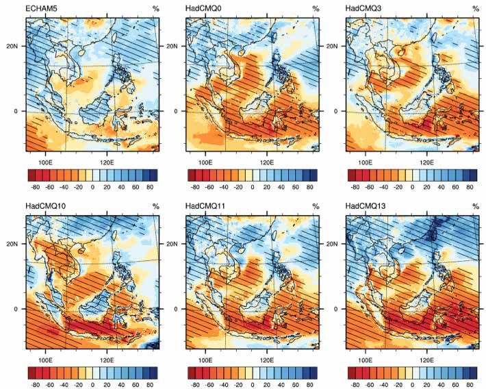
ABBREVIATIONS
ADB         Asian Development Bank
APASTI      ASEAN Plan of Action on Science, Technology and Innovation
ASEAN       Association of Southeast Asian Nations
ASEANCOF    ASEAN Climate Outlook Forum
CMA         China Meteorological Administration
CONOPS      Concept of Operations
CORDEX      Coordinated Regional Downscaling Experiment
CREWS       Climate Risk and Early Warning Systems
DCPC        Data Collection or Production Centre
DMH         Department of Meteorology and Hydrology
DOM         Department of Meteorology
ECMWF       European Centre for Medium-range Weather Forecasts
EFAS		      European Flood Awareness System
ENSO        El Niño-Southern Oscillation
EPS		       Ensemble Prediction System
ESCAP		     United Nations Economic and Social Commission for Asia and the Pacific
EUMETNET    European Meteorological Services Network
EWS         Early Warning System
FEWS        Flood Early Warning System
FFGS        Flash Flood Guidance System
FMMP        MRC’s Flood Management and Mitigation Programme
GCOS		      Global Climate Observing System
GDPFS       WMO Global Data-processing and Forecasting System
GISC        WMO Global Information System Centre
GOS		       WMO Global Observing System
GPC-LRF     WMO Global Producing Centre for Long-range Forecasts
GTS		       WMO Global Telecommunications System
HKO         Hong Kong Observatory
HRC		       U.S. Hydrologic Research Center
HYCOS       Hydrological Cycle Observing System
ICHARM      Centre for Water Hazard and Risk Management
IPCC        Intergovernmental Panel on Climate Change
IRI         International Research Institute for Climate and Society
IWRM        integrated water resources management
JICA        Japan International Cooperation Agency
JMA         Japan Meteorological Agency
KMA		       Korea Meteorological Administration
KRA         key results area (Typhoon Committee)
LAMs        limited area models
Lao PDR     Lao People’s Democratic Republic
LC-LRFMME   Lead Centre for Long-range Forecast Multi-model Ensemble

IV
ABBREVIATIONS             (CONTINUED)

MASAP       Mekong Adaptation Strategy and Action Plan
M-HYCOS     Mekong Hydrological Cycle Observation System
MONRE       Ministry of Natural Resources and Environment
MRC         Mekong River Commission
MSS		       Meteorological Service of Singapore
NASA		      U.S. National Aeronautics and Space Administration
NCEP		      NOAA/National Centers for Environmental Prediction
N-IWRMSP    National Integrated Water Resources Management Support Program
NHMS        National Hydro-Meteorological Service of Vietnam
NMC		       National Meteorological Centre
NMHS        national meteorological and hydrological service
NOAA		      U.S. National Oceanic and Atmospheric Administration
NUIST		     Nanjing University of Information, Science and Technology
NWP         Numerical Weather Prediction
OP		        Operating Plan
PTC		       WMO/ESCAP Panel on Tropical Cyclone
QPE		       Quantitative Precipitation Estimates
QPF		       Quantitative Precipitation Forecast
RA		        WMO Regional Association
RCC		       WMO Regional Climate Centre
RFSC		      WMO Regional Forecast Support Centre
RIMES       Regional Integrated Multi-hazard Early Warning System for Africa and Asia
RSMC		      WMO Regional Specialized Meteorological Centre
RTC		       WMO Regional Training Centre
RTH		       WMO Regional Telecommunication Hub
SCMG		      ASEAN Subcommittee on Meteorology and Geophysics
SEA		       Southeast Asia
SEAFFGS     Southeast Asia Flash Flood Guidance System
SSOP        Synergized Standard Operating Procedures
SWFDP       WMO Severe Weather Forecasting Demonstration Project
SWFDP-SeA   WMO Severe Weather Forecasting Demonstration Project – Regional Subproject in Southeast Asia
UNDP        United Nations Development Programme
UNECAFE     United Nations Economic Commission for Asia and the Far East
WHYCOS      WMO World Hydrological Cycle Observing System
WIGOS       WMO Integrated Global Observing System
WIS		       WMO Information System
WMC		       WMO World Meteorological Centre
WMO		       World Meteorological Organization
WWIS		      World Weather Information Service
WWW		       WMO World Weather Watch Programme

                                                                                                           V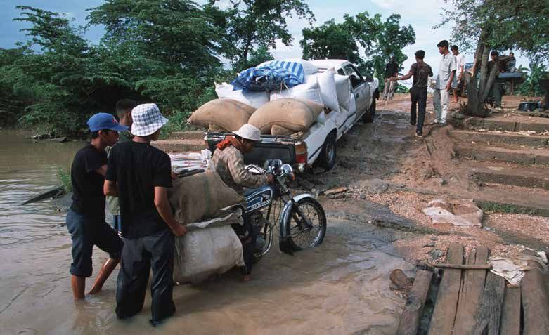
EXECUTIVE SUMMARY
SOUTHEAST ASIA DISASTER RISK PROFILE
The Southeast Asia (SEA) region is highly vulnerable to the impacts of natural hazards. Hydrometeorological hazards,
such as floods, droughts, landslides, and storm surges, pose a direct threat to lives and impact livelihoods by
damaging and destroying infrastructure, assets, and land. Underlying processes, including climate change impacts,
population growth, land use changes, and urbanization patterns, are increasing the number of people in SEA at risk
from hydrometeorological hazards. Despite a long tradition of coping with weather, climate, hydrological variability, and
extreme events, the SEA region continues to face serious challenges in managing the risk of disasters. In recent years,
a succession of typhoons, floods, and droughts has resulted in major loss of lives, livelihoods, and economic assets in
SEA, especially in Cambodia, Lao People’s Democratic Republic (Lao PDR), and Vietnam.
Weather, climate, and water know no national borders. The weather and climate conditions over the Indochina Peninsula,
along with the very complex air-land-water interactions in the Lower Mekong region (including Cambodia, Lao PDR, and
Vietnam), make it one of the most seriously imperiled regions on the planet. It faces an uncertain future due to climate
change, with more intense dry seasons, wetter monsoons, more significant floods and storms (with associated heavy
precipitation and strong winds), and rising sea levels. It is highly likely that SEA countries already feel the impact of
climate change. In 2009, Typhoon Ketsana left a trail of destruction across the Philippines, Vietnam, Cambodia, and Lao
PDR, while the powerful 2015/2016 El Niño caused widespread drought in the Lower Mekong region.

IMPORTANCE OF AND CHALLENGES IN INVESTING IN HYDROMETEOROLOGICAL SERVICES
Given the current and expected future impacts of weather-related hazards on countries in the region, governments
need high-quality hydromet information to protect people, economies, and development gains. To minimize growing
economic losses from hydrometeorological hazards, facilitate the adaptation to climate change, and guide economic
development across different sectors, countries have invested in stronger national capacity to improve their multi-
hazard early warning systems and weather, climate, and hydrological (hydromet) services. National meteorological and
hydrological services (NMHSs) traditionally play a critical role in the provision of these services and in tailoring them
to different users. National investments typically include upgrading of observing networks and related information and
communication technology (ICT), real-time access to reliable and accurate numerical forecast products, post-processing
and dissemination mechanisms, and cross-cutting institutional and technical capacity building.
While countries continue to invest in improved weather information services, challenges remain. The three SEA
countries targeted in this report—Cambodia, Lao PDR, and Vietnam—have NMHSs that are able to provide a basic
level of services, with Vietnam having higher capacity than the other two; but they all lag behind other countries in
the region in terms of core capacities, forecasting technology, development and delivery of value-added services, and
research and development. Limited financial, physical, and human resources make it difficult for the Cambodian, Lao,
and Vietnamese NMHSs to cope individually with the increasing demand for improved products and better services.
National investments are often provided through bilateral support and focus on separate elements of the hydromet
infrastructure without making systemic changes to the entire national system, due in part to the lack of compatibility
and interoperability among the separate systems.

REGIONAL DIMENSION
Regional initiatives offer many opportunities to support capacities of national hydromet service providers in the
SEA region. Cambodia, Lao PDR, and Vietnam face similar challenges in coping with common hydromet hazards. To
improve delivery of national hydromet services, it is critical to pursue regional hydromet strategies, as well as effective
regional cooperation, collaboration (within and outside the subregion), harmonization of efforts, and cross-boundary

VI
coordination. This approach in turn could help enable appropriate adaptation and mitigation measures to be developed
and implemented. Integration of the region’s hydromet systems provides opportunities to lower required investment
while increasing accuracy of forecasts. Observed data from the hydromet monitoring networks needs to be shared
with other NMHSs through regional data exchange in order to improve monitoring of hazardous hydromet conditions,
numerical modeling, and forecasting. The design of optimum regional composites for each of the subsystems—hydromet
observational networks, modeling, forecasting, and service delivery that meet the existing and future needs of societies—
would ensure robust interoperability, efficiencies, and optimization of infrastructure costs, together with a higher level
of harmonization, integration, and complementarity within the region.
A number of global and regional initiatives already exist that are relevant for SEA, although there are also challenges
in fully benefiting from regional opportunities. The foundations and precedents for regional cooperation exist in SEA
through the World Meteorological Organization (WMO), the United Nations Economic and Social Commission
for Asia and the Pacific (ESCAP), the Association of Southeast Asian Nations (ASEAN), and the Mekong River
Commission (MRC). Cambodia, Lao PDR, and Vietnam are participating in a number of regional initiatives
and projects, through which their NMHSs can gain access to satellite-based imagery and regional and global
Numerical Weather Prediction (NWP) products and services. However, there are also challenges at the national
level— technical, budgetary, and human resource–related—that hinder their uptake and integration into the national
systems and keep countries from fully complying with international commitments. Similarly, there are challenges
in scaling up these initiatives from demonstrations to operations, ensuring their relevance to national and regional
systems, and sustaining national participation.

OBJECTIVES AND OUTLINE OF THE POLICY NOTE
Increasing resilience to natural hazards directly supports the World Bank’s twin goals of eradicating extreme poverty
and boosting shared prosperity. The World Bank and other development partners are supporting SEA countries’ efforts
modernize their NMHSs, including through the series of Mekong Integrated Water Resources Management Projects,
the Lao PDR Southeast Asia Disaster Risk Management Project, the Ayeyarwady Integrated River Basin Management
Project, and several projects in Vietnam. Along with project financing and advisory services, the World Bank also
provides technical assistance to Cambodia, Lao PDR, and Myanmar under the Developing Strategic Plans for Disaster
Risk Financing, Risk Reduction and Hydromet Services in Southeast Asia program.
The objective of this policy note is to contribute to the ongoing discussion on the potential of regional coordination in
SEA. This policy note seeks to improve understanding of regional aspects of the development and delivery of hydromet
services in SEA; assess regional projects and existing international initiatives to promote regional cooperation; identify
gaps in these efforts; and discuss constraints on and opportunities for strengthening the regional dimension of hydromet
services, focusing on Cambodia, Lao PDR, and Vietnam. The note concludes with recommendations for the way forward
with short-, medium-, and long-term action plans. This analysis draws on the knowledge gathered through ongoing
World Bank engagements in the region, a desk review of existing literature, and limited consultations with stakeholders.

KEY FINDINGS AND RECOMMENDATIONS
Current hydromet conditions, including recent extreme hydromet events, along with expected future conditions
highlight the need for continued investment in modernizing hydrometeorological services in the SEA region. Given
that similar hazards face Cambodia, Lao PDR, and Vietnam, and that the countries have similar data and hydromet
information needs, there are benefits to taking a regional approach to monitoring and forecasting hazardous hydromet
conditions. The countries have different capabilities, but nonetheless, with more intense hazardous hydromet events
taking place and likely to occur in the future, building a regional dimension to hydromet services could save on the cost
of capital infrastructure as well as sustainable operation and maintenance.
A number of initiatives that focus on the different stages of the monitoring and forecasting process—such as data
collection, forecasting, dissemination of impact-based forecasts and early warnings, and delivery of weather, climate,
and hydrological services—could be utilized by subregional and national hydromet service providers, including in the
SEA region. Existing regional frameworks and initiatives in the SEA region could help address some of the major
challenges that national hydrometeorological service providers face.

                                                                                                                      VII
There are challenges in making use of these initiatives. These include scaling up specific initiatives from demonstrations,
  ensuring relevance to national and regional systems, and sustaining national participation. These challenges are linked to
  constraints in human and financial resources, and to a lack of awareness at the national level of the benefits offered by regional
  approaches. The sections below list the recommended actions that Cambodia, Lao PDR, and Vietnam could take to address
  some of these challenges.

        SHORT-TERM ACTIONS (ONE TO THREE YEARS)

  1. Develop a regional Concept of Operations for the Lower Mekong region.
  The development of a Concept of Operations (CONOPS) for the Lower Mekong region could guide the design and
  development of an optimum regional composite for hydromet observational networks, modeling, forecasting, and
  service delivery that meet societies’ existing and future needs. A well-defined regional CONOPS is intended as a living
  document that guides the implementation and ongoing operation of the system of subsystems; it should be clearly
  aligned with national CONOPS documents that address user needs. The national CONOPS document should also
  evolve with the system.
  Actions:
         (i)   Task the Management Team of the Severe Weather Forecasting Demonstration Project–Regional Subproject
               in Southeast Asia (SWFDP-SeA) to develop the regional CONOPS.
         (ii) Encourage donors and development partners to participate in and support the development of the regional
              CONOPS.
  2. Improve harmonization, compatibility, and integration of systems.
  Many development partners have supported and will continue to support separate elements of the hydromet
  infrastructure. Although these efforts could provide significant improvements, staff at NMHSs still struggle with data
  integration, typically because systems are not compatible or interoperable. This lack of integration creates bottlenecks
  and inefficiencies in operations. Recent World Bank projects have been focusing on systems’ integration, but these
  have been nationally driven. Noting that harmonization, compatibility, and integration are common challenges among
  the countries in the Lower Mekong region, the existing World Bank initiative should be scaled up to address this
  problem at the regional level. This will result in cost saving and promote efficiency and effectiveness in the systems,
  while contributing to improved monitoring and increased accuracy of forecasts.
  Actions:
         (i)   As part of the regional CONOPS for the Lower Mekong region, develop standardized technical specifications
               for the various components of the observation network (including automatic weather stations, radio sounding,
               radar, etc.)
         (ii) Establish formal agreements between the NMHS and the development partner or donor on the use of
              such technical specifications, which should be developed in the context of the regional CONOPS to allow
              integration.
         (iii) Encourage donors and development partners to comply with the technical specifications developed in the
               context of the regional CONOPS.
  3. Enhance data collecting and sharing.
  WMO adopted data-sharing policies with the intent of establishing a system for free and unrestricted exchange of
  weather, climate, and hydrological data and products at the international level; but many NMHSs are not able to comply
  due to political, technical, and resource issues. Regional policies are more effective, such as those established by MRC
  for hydrological data sharing among the countries in the Mekong basin. Given that the National Hydro-Meteorological
  Service (NHMS) of Vietnam is the Regional Forecast Support Centre and acts as a WMO regional hub for forecasting
  (making available graphical forecast products from global and regional service providers), it could extend its role to
  coordinate sharing of meteorological observational and forecasting data in the Lower Mekong region.

VIII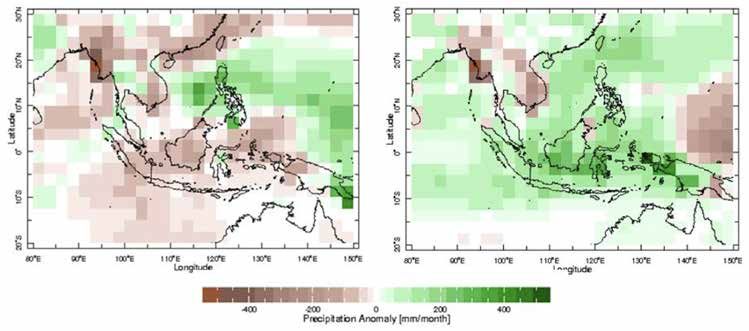
Actions:
      (i)   Assign to the NHMS of Vietnam (as the WMO Regional Forecast Support Centre) the role of coordinator
            of meteorological observational and forecasting data sharing in the Lower Mekong region.
      (ii) Establish data-sharing protocols and agreements with global and regional service providers in Southeast Asia
           in order to get access to digital data (not only graphical products).
4. Strengthen ICT assets and infrastructure with the international community.
To ensure that individual NMHSs can quickly access data and products from existing global and regional initiatives, and
can also contribute observational data for improving numerical forecast accuracy, a key priority is the acquisition and
installation of the WMO Information System (WIS)/Global Telecommunication System (GTS) in individual countries. This
allows communication with the international community through the WMO’s World Weather Watch (WWW) infrastructure.
Actions:
      (i)   Acquire and install the WIS/GTS in individual countries, along with related ICT infrastructure and/or cloud computing.
      (ii) Upgrade to reliable high-speed Internet in individual countries.
      (iii) Establish formal agreements with WMO/WIS centers—e.g., the Data Collection or Production Centre (DCPC)
            in Bangkok and Global Information System Centres (GISCs) in Beijing and Tokyo—for continuous support and
            capacity building in ICT system operations.
5. Improve monitoring and nowcasting of hazardous hydromet conditions.
The Southeast Asia Radar Network/Composite project aims to enhance expertise in the field of weather radar within
the ASEAN region and provide capacity building on radar observation and its utilization. This project is important
for nowcasting (that is, monitoring and extrapolation of weather conditions in the present and immediate future),
especially for transboundary hazardous events; it is also important for determining Quantitative Precipitation Estimates
(QPE) required for hydrological monitoring and forecasting. However, there have been significant technical challenges
associated with its implementation, as NMHSs in SEA must first be able to manipulate and use the relevant radar data.
Actions:
      (i)   Establish a formal collaboration mechanism with the WMO Regional WIGOS Centre Tokyo and with the
            NMHS of Thailand, which has recently been trained in the use and manipulation of radar data, and make data
            available to the regional radar composite.
      (ii) Work with Hong Kong Observatory to implement SWIRLS (Short-range Warning of Intense Rainstorms
           in Localized Systems) at the WMO Regional Forecast Support Centre in Vietnam, once the regional radar
           composite is in place.
6. Run and calibrate a regional numerical model.
With global NWP models now reaching the resolutions served by previous-generation local and regional deterministic
limited area models (LAMs), efficient provision of such NWP services is best concentrated in a limited number of
regional centers, such as the Regional Forecast Support Centre Hanoi, which has been significantly strengthened both
in terms of hydromet infrastructure, equipment and technical skills.
Actions:
      (i)   Strengthen the capabilities of Vietnam’s NHMS as the Regional Forecast Support Centre to ensure that
            demonstration functions within the context of the SWFDP-SeA and Southeast Asia Flash Flood Guidance
            System (SEAFFGS) make the transition to operations.
      (ii) Establish a Lower Mekong Region Consortium for numerical modeling and invite staff from the three NMHSs
           to participate in the development, testing, and calibration of the regional model.
      (iii) Encourage donors and development partners to support regional functions of the NHMS of Vietnam and the
            participation of staff from NMHSs of Cambodia and Lao PDR in the consortium.

                                                                                                                               IX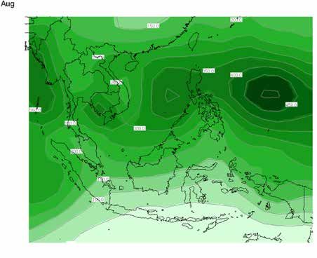
(iv) Use model codes and parameterizations being shared within the WMO Regional Association II (Asia), which
           are supported by World Meteorological Centres (WMCs) in Beijing and Tokyo.
      (v)   Establish formal agreements with WMCs in Beijing and Tokyo for continuous support and capacity building.
7. Establish formal collaborations with global and regional centers and universities for capacity building.
Training is an integral and essential part of modernization. Training should be carried out for all staff in their respective
areas of expertise and responsibility and could be offered on-the–job, at WMO Regional Training Centres (RTCs), etc.
Academia and research institutions are also supporting capacity building.
Actions:
      (i)   Establish a formal agreement with global and regional centers—e.g., WMCs in Beijing and Tokyo, Southeast
            Asia Regional Climate Centre (RCC)-Network—to provide in-country training using the systems and
            equipment available to center staff, and to introduce the new products and tools made available to them
            through global and regional initiatives.
      (ii) Have the Vietnamese NHMS (in its capacity as the Regional Forecast Support Centre) provide in-country
           training at NMHSs of Cambodia and Lao PDR to boost their operational capacities.
      (iii) Have regional centers or institutions (in charge of regional weather, climate, or hydrological forecast support)
            assess national requirements, coordinate the development of curricula that include the introduction of new
            products and tools, and coordinate the engagement of relevant experts who could be deployed for a specific
            time period at the national level.
      (iv) Identify qualified staff from the 3 NMHSs to be trained as trainers of other staff, at the WMO RTCs in
           Republic of Korea and China.
      (v)   Have RTCs in Korea and China review the training curricula to ensure that they are fit-for-purpose and
            address the requirements of the NMHSs in the Lower Mekong region.
      (vi) Establish protocols with academia and research institutions, including universities, to ensure that research
           studies are aligned with the research needs of the NMHSs (e.g., verification of numerical forecasts, post-
           process and calibration of model outputs, etc.)

     MEDIUM-TERM ACTIONS (FOUR TO FIVE YEARS)
8. Focus on data quality and availability.
One of the functions of the WMO Regional WIGOS Centres is to carry out performance monitoring and incident
management (under the WIGOS Data Quality Monitoring System) and follow up with data providers (i.e., the NMHSs)
in case of data availability or data quality issues. Data quality and availability (which are crucial for hydromet monitoring
and forecast verification) are critical issues for NMHSs in developing countries.
Actions:
      (i)   Establish a good connection between the NMHSs of Cambodia, Lao PDR, and Vietnam and the Regional
            WIGOS Centre Tokyo, which would assist and support capacity development in this area.
      (ii) Promote the introduction of routine quality assurance/quality control of observations at individual NMHSs,
           as part of existing and future projects supported by donors and development partners.

X
9. Improve harmonization of warning criteria and of efforts to share warnings among the three
countries in the region.
In line with the development of regional capacity for disaster risk management in SEA, there is a need to harmonize
the warning criteria for hydromet hazards within the Lower Mekong region. It is important for individual countries to
share and display the alerts and warnings for at least 48 hours, in a manner understandable for professionals and the
public, using a dedicated regional web platform. An example of such a platform is Meteoalarm, which was developed
under the framework of the European Meteorological Services Network (EUMETNET) (and which recently incorporated
hydrological warnings).
Actions:
(i) Harmonize the warning criteria for hydromet hazards within the Lower Mekong region.
(ii) Share and display the alerts and warnings from individual countries for at least 48 hours, and do so in a
manner that is understandable for professionals and the public using a dedicated regional web platform.
(iii) Over the longer term, build on strengthened coordination with the regional and national disaster risk
management community to harmonize these warnings toward impact-oriented warnings.
LONG-TERM ACTIONS (6 TO 10 YEARS)
10. Improve technical skills, operations and maintenance capacity, and engagement with the private sector.
To contribute to efficiencies and optimization of infrastructure costs and facilitate integration and complementarity
within the region, the approach to investing in modernization of NMHSs should be rethought. Efforts to modernize
should take into account the national and regional CONOPS, shift the focus from infrastructure to a service-based
approach at the national level, support the regional hydromet dimension through the short- to medium-term actions
suggested above, and engage with the private sector. These steps could also contribute to affordable operation and
maintenance costs to be supported by governments.
Actions:
(i) Develop new business models for the NMHSs by shifting focus from infrastructure to a service-based
approach at national level, supporting the regional hydromet dimension through the short- to medium-term
actions suggested above, and engaging with the private sector.
(ii) Develop a program for mobilization of staff to fill in the technical capacity gaps among the three countries
in the Lower Mekong region, while building the capacity of new staff through a comprehensive education and
training program.
XIPhoto: World Bank. Location: Luang Prabang, Laos
CHAPTER 1

WEATHER AND CLIMATE EVENTS RELATED
TO DISASTERS IN SOUTHEAST ASIA
This chapter describes the main weather and climate characteristics of Southeast Asia (SEA), summarizing current as
well as projected conditions linked to climate change impacts. Technical Insight 1 highlights the regional nature of
hydrometeorological hazards in the Lower Mekong region and illustrates their impacts in two cases: the 2009 Ketsana
typhoon and the 2015/2016 drought.

CLIMATE AND WEATHER CONDITIONS IN SOUTHEAST ASIA
The SEA region has a tropical climate characterized by relatively uniform warm and humid weather all year round.
However, the rainfall patterns vary significantly across the region, which allows further classification of the tropical
climate, as described below (Köppen 1936) and shown in Figure 1.
         (1) The tropical rainforest climate has high and uniform rainfall through the year. It is typical of the near-
             equatorial regions such as Malaysia, Brunei Darussalam, Singapore, and some parts of the Indonesian
             archipelago, including Sumatra and Kalimantan.
         (2) The tropical monsoon or savanna climate has distinct dry and wet seasons and is found mainly in the
             northern SEA region, including Myanmar, Thailand, Cambodia, Lao People’s Democratic Republic (Lao PDR),
             Vietnam, and the Philippines. A temperate climate can also be found in the northern parts of Myanmar, Lao
             PDR, and Vietnam, due to their elevated geographic features.
Induced by maritime wind systems originating in the South China Sea and in the Indian Ocean, two main monsoon
seasons affect the SEA region: the northeast monsoon (also called winter monsoon) from December to March, and the
southwest monsoon (also called summer monsoon) from June to September. These two seasons, which often bring
extreme weather conditions, are separated by two relatively shorter intermonsoon periods.

                                FIGURE 1: KÖPPEN CLIMATE CLASSIFICATION FOR SOUTHEAST ASIA

Source: ASEAN Specialized Meteorological Centre (ASMC), “ASEAN Regional Climate Outlook Forum:
        What Is the Climate of the Southeast Asia Region?,” http://asmc.asean.org/asmc_asean_cof_about/.              1
In the northern part of the SEA region (i.e., Cambodia, Lao PDR, Myanmar, northern Philippines, northern Thailand, and Vietnam), the northeast monsoon is characterized by a dry season ( with
A CHANGING CLIMATE
Seneviratne et al. (2012) shows that a changing climate in general leads to changes in the frequency, intensity, spatial
extent, duration, and timing of weather and climate events. Many countries in the SEA region are already feeling the
impact of climate change (Yusuf and Francisco 2009), including more frequent heat waves, more intense tropical storms,
and coastal inundation resulting from sea-level rise. Sea levels are expected to rise at least 1 m during this century,
according to IPCC (2014), and this increase can be temporarily intensified by storm surges primarily caused by typhoons
approaching land. Figure 3 shows a moderate increased trend in hydromet disasters, especially hydrological disasters,
in SEA in the last three decades.
FIGURE 3: NUMBER OF METEOROLOGICAL, CLIMATOLOGICAL,
AND HYDROLOGICAL DISASTERS IN SOUTHEAST ASIA, 1900 TO 2017
60
Climatological
Hydrological
Meteorological
Total
Number
of
Disasters
in 30
Southeast
Asia
0
1900 1960 2010
Year
Source: EM-DAT: The Emergency Events Database—Université catholique de Louvain (UCL)
CRED, D. Guha-Sapir—www.emdat.be, Brussels, Belgium.
Note: Meteorological disasters include extreme temperatures, fog, and storms; climatological disasters
include droughts and wildfires; and hydrological disasters include floods and landslides.
However, the link in SEA between global warming and the seasonal atmospheric flow during the monsoon seasons
remains fuzzy. In general, changes in monsoon-related extreme precipitation and winds due to climate change are
not well understood (Seneviratne et al. 2012). While there is little consensus among climate models and hence low
confidence in projections of change in monsoons, there is evidence of disruptions in the normal monsoon cycle. These
disruptions are typically caused by the El Niño-Southern Oscillation (ENSO), whose impacts are detailed in Box 1.
3BOX 1: EL NIÑO-SOUTHERN OSCILLATION (ENSO)
The El Niño-Southern Oscillation (ENSO) is a natural fluctuation of the global climate system caused by equatorial
ocean-atmosphere interaction in the tropical Pacific Ocean (Philander 1990). The term “Southern Oscillation”
refers to a tendency for above-average surface atmospheric pressures in the Indian Ocean to be associated with
below-average pressures in the Pacific, and vice versa. This oscillation is associated with variations in sea surface
temperatures in the east equatorial Pacific. The oceanic and atmospheric variations are collectively referred to as
ENSO. An El Niño episode is one phase of the ENSO phenomenon and is associated with abnormally warm central
and east equatorial Pacific Ocean surface temperatures, while the opposite phase, a La Niña episode, is associated
with abnormally cool ocean temperatures in this region. Both phases are associated with a characteristic spatial
pattern of droughts and floods. Recent research (e.g., Zhang et al. 2010) has demonstrated that different phases
of ENSO (El Niño or La Niña episodes) also are associated with different frequencies of occurrence of short-term
weather extremes, such as heavy rainfall events and extreme temperatures. The relationship between ENSO and
interannual variations in tropical cyclone activity is well known (see e.g. Kuleshov et al. 2008).
In SEA, in particular in the Indochina Peninsula, the El Niño episode brings warmer and dryer weather and typically
exacerbates the dry season with prolonged dry spells, often leading to droughts and sometimes intense forest fires (see
Technical Insight 1). In a La Niña episode, the climate anomalies are usually the opposite of those in an El Niño—that is,
a La Niña episode is characterized by higher-than-normal rainfall, which may result in an increased occurrence of floods.
The correlation between El Niño/La Niña and its associated weather impacts in SEA differs by place and by season. Figure
4 shows the precipitation anomalies (in relation to the climatology) averaged over the El Niño and La Niña years during the
months of June to October. During these months, the impact of El Niño (i.e., dryer weather) is typically stronger over the
southern and eastern part of SEA (including the Indochina Peninsula).
FIGURE 4 : DISTRIBUTION OF PRECIPITATION ANOMALIES OVER SOUTHEAST ASIA
(JUNE–OCTOBER) FOR EL NIÑO (LEFT) AND LA NIÑA (RIGHT) YEARS
Source: ASEAN Specialized Meteorological Centre (ASMC), “ASEAN Regional Climate Outlook Forum:
What Is the Climate of the Southeast Asia Region?,” http://asmc.asean.org/asmc_asean_cof_about/.
4The fifth IPCC Report (IPCC 2014) indicates that warming is very likely to continue in SEA, with substantial subregional
variations. There is medium confidence in a moderate increase in rainfall over the Indochina Peninsula, but to the south
there is generally a drying tendency, although this may not be significant relative to the natural decadal variations
in this region. Strong regional variations are expected because of SEA’s topographic characteristics and land-ocean
configuration. The complex geographic features of SEA (i.e., land, ocean, mountains, etc.) make it difficult to understand
climate change scenarios in the region. To address this difficulty, numerous research studies have been carried out
in the context of the Southeast Asia Coordinated Regional Downscaling Experiment (CORDEX) project, which have
significantly contributed to understanding climate change scenarios at the regional level. Rahmat et al. (2014) conclude
that relative to the baseline period of 1971–2000, the annual cycle change in temperature was around 2°C for the
mid-term projections (that is, for the 30-year period between 2031 and 2060) and around 4°C for the long-term (the
30-year period between 2071 and 2100).
In contrast, the projections for precipitation show large spatial and seasonal variations, which lead to difficulties in
understanding the annual cycle. But generally, the projections show drier climate over the sea and wetter climate over
land. During the southwest monsoon (June to August), generally more rainfall is projected in the northern part of the
region (from approximately 20°N and northward), whereas drier conditions are projected for the Maritime Continent
(see Figure 5). For the northeast monsoon (December to February), the scale of projected changes in precipitation
(e.g., increases over land) for extremes is not as significant as for the southwest monsoon.
FIGURE 5: FUTURE PERCENTAGE CHANGE IN SEASONAL MEAN RAINFALL FOR
END-CENTURY (2071–2100) RELATIVE TO THE BASELINE PERIOD (1971–2000)
IN JUNE-JULY-AUGUST FOR SIX DIFFERENT MODEL SCENARIOS
Source: Rahmat et al. 2014.
Note: Blue (red) shades show projected wetter (drier) locations. Hatching shows areas with significant changes.
5Technical Insight 1: The regional nature of hydromet hazards in the Lower Mekong region
The Lower Mekong region (including Cambodia, Lao PDR, and Vietnam) is predominately influenced by the dry-
season northeast monsoon (from December to March) and by the wet-season southwest monsoon (from June
to September). Associated with very complex air-land-water interactions in the Mekong basin, and the natural
fluctuations of the global climate system (such as El Niño/La Niña), these two seasons often bring extreme
hydromet conditions to SEA, which is one of the most disaster-prone areas on the planet. While there is medium
confidence in the climate projections for the region, these countries are already feeling the impact of climate
change, including more frequent heat waves, prolonged dry spells leading to drought, more intense tropical storms,
and severe floods. Two recent examples of the serious regional impacts are described below. They highlight the
need for regional investments to improve the quality of hydrometeorological information in this region.
Typhoon Ketsana (September 2009)—In the last few decades, the countries of the SEA region have been exposed
to rising land and ocean surface temperatures, along with weather and climate events of increased intensity and
frequency. The year 2009 proved to be no exception to that trend. In the western North Pacific Ocean basin,
22 named tropical storms were recorded, 13 of which reached the intensity of typhoon. One of these storms,
Typhoon Ketsana, was the world’s second deadliest tropical cyclone of that year (WMO 2009). According to press
reports, strong winds and heavy rain associated with Typhoon Ketsana caused severe flooding in SEA, triggering
significant casualties and damage across the Philippines, Vietnam, Cambodia, and Lao PDR (see Figure 6 for the
Typhoon Ketsana track analysis).
FIGURE 6: TYPHOON KETSANA TRACK ANALYSIS
30N
20N
[Circle]
6-hourly position
[Circle with number]
Position at 00UTC
Number: Day
10N
TY
STS
TS
TD or L
E0
100E 120E 140E
Source: Analysis archive of the RSMC-Typhoon Center Tokyo, hosted by the Japan Meteorological Agency,
http://www.jma.go.jp/en/typh/; also available in JMA 2009.
6Drought in the Lower Mekong region (2015/2016)—The Fifth Session of the ASEAN (Association of Southeast Asia
Nations) Climate Outlook Forum (ASEANCOF-5), held in November 2015, indicated an enhanced likelihood for
the Lower Mekong region to experience drier-than-normal conditions in December-January-February 2015/2016,
due to the strong and mature 2015/2016 El Niño event. The regional consensus maps showing the probabilistic
rainfall outlook (Figure 7) and temperature outlook (Figure 8) that were issued in November 2015 clearly show
below-normal rainfall and well-above-normal temperatures in the Lower Mekong region. This
common outlook for rainfall and temperature highlights the importance of regional cooperation
to improve resilience and adaptation to climate change in preparation for naturally occurring
disaster events, such as this powerful 2015/2016 El Niño, which caused widespread drought
with significant impact in various sectors in the Indochina Peninsula.
FIGURE 7: PROBABILISTIC RAINFALL FIGURE 8: PROBABILISTIC TEMPERATURE
OUTLOOK ISSUED IN NOVEMBER 2015 OUTLOOK ISSUED IN NOVEMBER 2015
Source: ASEANCOF-5, “Consensus Bulletin for December-January-February (DJF) Source: ASEANCOF-5, “Consensus Bulletin for December-January-February
2015-16 Season,” http://asmc.asean.org/wp-content/uploads/2015/11/ (DJF) 2015-16 Season,” http://asmc.asean.org/wp-content/uploads/2015/11/
ASEANCOF-5-Outlook-Bulletin-for-DJF-2015-16-FINAL.pdf. ASEANCOF-5-Outlook-Bulletin-for-DJF-2015-16-FINAL.pdf.
KEY TAKEAWAYS
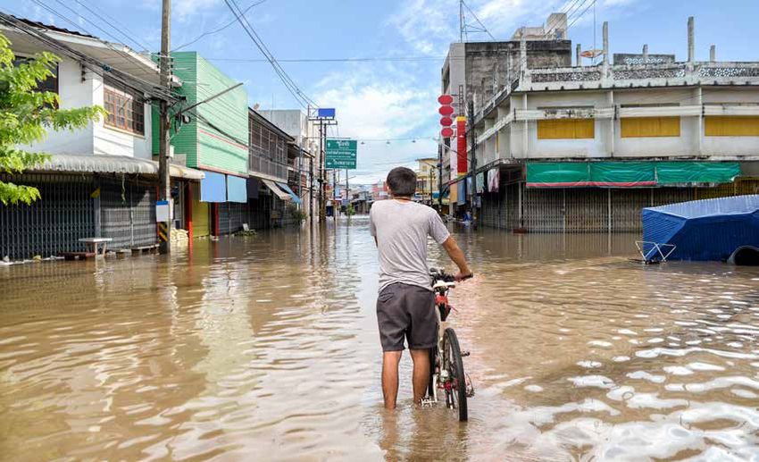
SEA is highly vulnerable to the impacts of a range of natural hazards, including floods, droughts, landslides, and storm
surges. Cambodia, Lao PDR, and Vietnam often face common meteorological and hydrological hazards. Disasters
pose a direct threat to lives; they impact livelihoods by damaging and destroying infrastructure, assets, and land;
and they ultimately disrupt development outcomes. Given existing risks and projected changes in the region’s
climate conditions, countries urgently need access to accurate and timely weather information.
7Photo: World Bank photo collection/Flickr.com Location: Vietnam.
CHAPTER 2

THE SOUTHEAST ASIAN
HYDROMET SERVICES IN A NUTSHELL
This chapter provides a brief overview of the state of the hydromet service providers in the SEA region. Specifically,
it looks at the capabilities of the national meteorological and hydrological services (NMHSs) in Cambodia, Lao PDR,
and Vietnam and at ongoing major initiatives led by respective governments, donors, and development partners. The
current state of these services highlights the need for investments at the national level to ensure a unified approach
and improve synergies between different initiatives, as well as the potential benefits of strengthening the regional
dimension of these services to bring them in line with international practice.

ROLE OF NATIONAL METEOROLOGICAL AND HYDROLOGICAL SERVICES
To minimize growing economic losses from hydrometeorological hazards, facilitate adaptation to climate change,
and guide economic development across different sectors, countries invest in national capacity to provide improved
multi-hazard early warnings as well as weather, climate, and hydrological (hydromet) services. The NMHSs are the
national institutions responsible for observing and understanding weather and climate and for providing related
services in support of national needs, especially as they pertain to (a) protecting life and property; (b) safeguarding
the environment; (c) contributing to sustainable development; (d) promoting long-term observation and collection
of meteorological, hydrological, and climatological data, including related environmental data; (e) promoting
endogenous capacity development; (f) meeting international commitments; and (g) contributing to international
cooperation (WMO 2015b).
While countries in the Indochina Peninsula are impacted by common meteorological and hydrological hazards, a close
look at the hydromet services in Cambodia, Lao PDR, and Vietnam reveals different capacities among the NMHSs (Table
1). Various development partners have made and will continue to make investments in observational infrastructure,
forecasting, and service delivery in these individual countries, but there are still challenges and gaps in the existing
systems, which could be addressed through—and benefit from—building a regional dimension to hydromet services (see
Technical Insight 2). A summary of the investments being made to strengthen the capabilities of NMHSs in Cambodia,
Lao PDR, and Vietnam is provided below. Information on the capacities and the investments of these services is based
on existing literature and recent reviews conducted on behalf of the World Bank.

                                                                                                                      9
CAMBODIA
Cambodia’s Department of Meteorology (DOM), under the Ministry of Water Resources and Meteorology, is responsible
for the operation and maintenance of all meteorological observations and for issuance of weather forecasts, severe
weather warnings to support disaster risk management, and climate information. It provides weather services to aviation
and land transportation, agriculture, and other sectors. In dealing with hydrometeorological hazards, DOM partners
with the Department of Hydrology and River Works (also under the Ministry of Water Resources and Meteorology),
which maintains and monitors hydrological stations along the river systems of Cambodia.
Compared to most of the NMHSs in SEA countries, DOM and the Department of Hydrology and River Works have
relatively limited technical expertise, human resources, and financial resources to carry out their mission. Their
observation networks, production system, and current financial resources have been improved with the support of the
Government of Cambodia and various development partners; however, they are still not adequate to ensure weather,
climate, and hydrological information and services that meet the rapidly growing and demanding needs of the different
sectors, including socioeconomic needs and those of the public (from community to national level).
In particular, the Government of Cambodia has sought to upgrade DOM’s capabilities by providing the budget for
S-band radar that covers most of the country, and for modern forecaster workstations and communication systems
that allow access to global and regional Numerical Weather Prediction (NWP) and satellite products. However, DOM
still faces many difficulties, notably the lack of experience and dedicated staff needed to operate the new systems. In
addition, strengthening the surface observation networks is still required for both monitoring and radar data calibration.
This would ensure improved quality of its data.
Several steps have been taken to strengthen hydrology in Cambodia. The Mekong River Commission (MRC) supported
the Mekong Hydrological Cycle Observation System (M-HYCOS) project with the installation of 12 hydrological stations
in Cambodia. The Asian Development Bank (ADB) financed establishment of the National Flood Forecasting System
and capacity technical assistance designed to (a) manage water resources through strengthening the strategy, policy,
and legal framework for integrated water resources management (IWRM), and (b) promote IWRM and climate change
adaptation. The World Bank has supported a regional series of Mekong Integrated Water Management Projects that
aims to strengthen the capacity of governments in the Lower Mekong (Cambodia, Lao PDR, and Vietnam) to better
manage water resources; projects have focused on hydromet network modernization and the transboundary elements
of the Mekong river basin, among other concerns.
Other activities and projects in Cambodia include the following:
• ADB’s Greater Mekong Subregion Flood and Drought Risk Management and Mitigation Project (2013–
2019). This project has a component that supports the development of design criteria for flood and drought
risk mitigation schemes and water control infrastructure in the Mekong Delta and elsewhere, the assessment
of cross-border flood management options in Vietnam and Cambodia, and the strengthening of the National
Flood Forecasting Center (ADB 2012).
• United Nations Development Programme (UNDP)/ Global Environment Facility project Strengthening
Climate Information and Early Warning Systems in Cambodia to Support Climate Resilient Development and
Adaptation to Climate Change (2014-2018). This project aims to establish an effective early warning system
(EWS) to allow timely preparation for extreme events, as well as climate-resilient development planning.
• Typhoon Committee’s Synergized Standard Operating Procedures for Coastal Multi-hazards Early Warning
System Project. This project is supported by the United Nations Economic and Social Commission for Asia
and the Pacific (ESCAP) trust fund.
10LAO PDR
The Department of Meteorology and Hydrology (DMH), under the Ministry of Natural Resources and Environment
(MONRE), is responsible for meteorological and hydrological observations, forecasting, and early warning of hydrological
and meteorological hazards. As part of its mandate, DMH provides hydromet information and services to a wide range of
water resource planning and management activities. It also provides weather services to aviation and land transportation
and supports decision making with climate outlooks.
The DMH has received financial support from various entities—the World Bank, ADB, Global Environment Facility,
Food and Agriculture Organization of the United Nations, and others—to strengthen the national capacity to observe,
forecast, and provide early warnings of hydrometeorological hazards. In particular, the World Bank has funded the
regional Mekong Integrated Water Resources Management Project to promote IWRM along the Mekong River. The
Lao portion of the Mekong Integrated Water Management Project has the following two components: (a) institutional
support for various departments in MONRE for water resources management, and (b) on-the-ground IWRM actions for
selected priority basins, including hydromet strengthening and model developing for river basin planning. In addition,
the World Bank is also supporting the Lao PDR Southeast Asia Disaster Risk Management Project to reduce the impacts
of flooding in Muang Xay and enhance the government’s capacity to provide hydrometeorological services and disaster
response. Component 2 of this project—Hydromet Modernization and Early Warning Systems—is implemented by
DMH, and includes among other goals (a) strengthening early warning systems and service delivery systems, and (b)
modernizing the observing, forecasting, and communications systems.
ADB is building capacity for the MONRE. The program, named the National Integrated Water Resources Management
Support Program (N-IWRMSP), has 10 components; under the fourth component, support is provided to the DMH to
strengthen its surface observing network. In addition, the Mekong River Commission supported the installation of 11
hydrological stations in Lao PDR as part of the Mekong Hydrological Cycle Observation System (M-HYCOS) project.
The Japan International Cooperation Agency (JICA) has been supporting DMH for many years, including through
installation of the C-band Doppler radar and long-term expert attachment to DMH to support radar operations. JICA has
also supported the Project for Improvement of Equipment and Facilities on Meteorological and Hydrological Services,
which aims to reduce the damage caused by meteorological and hydrological disasters in Lao PDR by strengthening
DMH observational and telecommunication systems.
The Food and Agriculture Organization of the United Nations has recently initiated a project for Strengthening Agro-
climatic Monitoring and Information Systems to Improve Adaptation to Climate Change and Food Security in Lao
PDR. This project will enhance DMH monitoring, analysis, communication, and use of agro-meteorological data and
information for decision making in relation to agriculture and food security at national and provincial levels.
11You can also read