TOWN OF HATFIELD - COMMUNITY RESILIENCE BUILDING WORKSHOP SUMMARY OF FINDINGS JUNE 25, 2021 - Mass.gov
←
→
Page content transcription
If your browser does not render page correctly, please read the page content below
TOWN OF HATFIELD

COMMUNITY RESILIENCE BUILDING WORKSHOP
         SUMMARY OF FINDINGS
              JUNE 25, 2021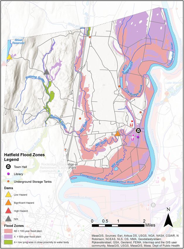
1936 Flood, North Hatfield (Source: Library of Congress)

Cover Photo
Hatfield, MA (Source: Rusty Clark)
Table of Contents
1. Overview ......................................................................................................................................... 1
2. Community Resilience Building Workshop ...................................................................................... 2
3. Top Hazards & Vulnerable Areas ..................................................................................................... 7
   Areas of Concern (Specific Locations) ............................................................................................. 9
4. Current Concerns and Challenges Presented By Hazards and Climate Change ............................. 11
   Projected Changes in Hatfield’s Climate ....................................................................................... 11
   Impacts of Climate Change on Hazards in Hatfield ....................................................................... 13
5. Specific Categories of Concerns and Challenges ........................................................................... 17
   Infrastructural Vulnerabilities ....................................................................................................... 17
   Societal Vulnerabilities ................................................................................................................. 22
   Environmental Vulnerabilities ...................................................................................................... 24
6. Current Strengths and Assets ........................................................................................................ 28
   Infrastructural Strengths .............................................................................................................. 28
   Societal Strengths ......................................................................................................................... 28
   Environmental Strengths .............................................................................................................. 29
7. Top Recommendations to Improve Resilience to Hazards ............................................................ 30
   Additional Priorities ...................................................................................................................... 35
8. Possible Funding Sources .............................................................................................................. 37
9. CRB Workshop Participants ........................................................................................................... 38
10. MVP Project Team....................................................................................................................... 39
11. Citation........................................................................................................................................ 39
12. References .................................................................................................................................. 40
13. Appendices .................................................................................................................................. 42
    1.       Combined Workshop Matrix ............................................................................................... 42

Hatfield CRB Workshop Summary of Findings                                                                                                             i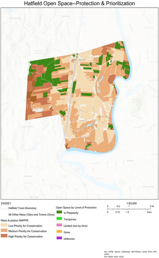
1. OVERVIEW
As the effects of climate change become more apparent globally and locally, the Town of Hatfield—
like communities across the Commonwealth of Massachusetts—has begun to plan for the
unavoidable impacts of climate change. In recent decades, the impacts of climate change have
become widely evident. Average annual temperatures in Massachusetts have increased by about
3°F over the past century 1 with greater increases in more recent decades—half of a degree per
decade since the 1970s. Meanwhile Massachusetts has seen an 81% increase in extreme
precipitation events since 1948 2.
Mindful that its future will be shaped by climate change, Hatfield applied for and was awarded a
grant for Municipal Vulnerability Preparedness (MVP) Planning from the Executive Office of Energy
and Environmental Affairs (EOEEA) MVP program. The MVP program is Massachusetts’ flagship effort
to support towns and cities in building local resilience and preparing for climate change.
Municipalities that complete the MVP Planning process become “MVP-certified” which makes them
eligible for MVP Action grants to implement projects identified during the planning process.
Communities across the state have received millions of dollars in recent years to protect or update
local infrastructure, harness natural processes to reduce flooding and its impacts, update local
bylaws, improve emergency communication, and more.
This report describes Hatfield’s MVP planning process, records the key information that it gathered,
and presents recommendations for increasing resilience in Hatfield.
This plan is focused on climate change adaptation—moderating the harm caused by climate
change. It does not address climate change mitigation—the long-term reduction of climate change
by reducing greenhouse gas emissions and sequestering atmospheric carbon. Both climate change
mitigation and adaptation will be required to secure a livable future for Hatfield.

    Top Priority Climate-Resilience Actions for Hatfield
    The MVP planning process identified the following top actions for building Hatfield’s climate
    resilience:
        • Assess Conditions at the Connecticut River Dike and at the Wastewater Treatment Plant
        • Plan for Relocation of Town Center Critical Facilities out of the Floodplain
        • Conduct a Town-Wide Drainage and Stormwater Study and Strategy
        • Incentivize Climate Resilient Farming
        • Plan for Future Climate-Resilient Development
        • Create a Climate Resilient Town Master Plan

1
 Northeast Climate Adaptation Science Center, “Massachusetts Climate Change Projections.”
2
 Madsen and Wilcox, “When It Rains, It Pours: Global Warming and the Increase in Extreme Precipitation from 1948 to
2011.”

Hatfield CRB Workshop Summary of Findings                                                                         1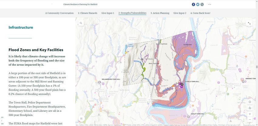
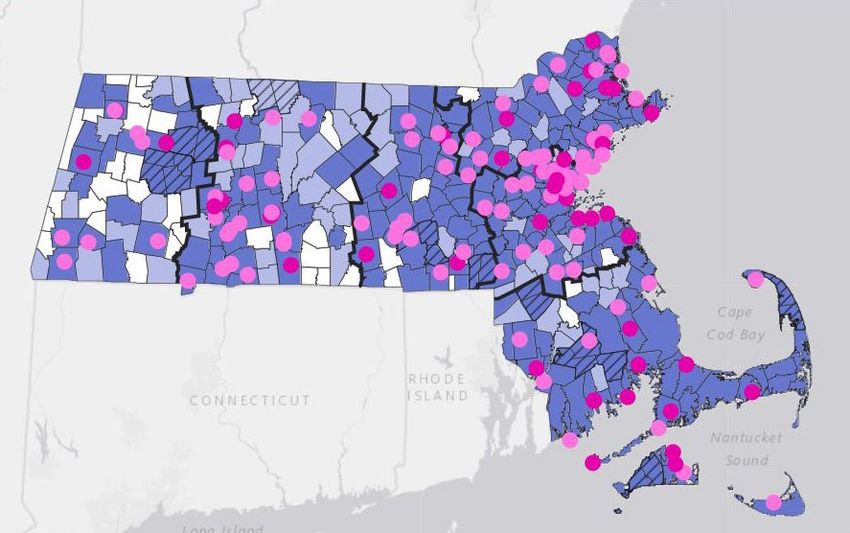
2. COMMUNITY RESILIENCE BUILDING WORKSHOP
Hatfield received a Municipal Vulnerability Preparedness (MVP) grant in 2020. The project was led
by a core team that included: Marlene Michonski, Town Administrator; Bob Flaherty, Fire Chief;
Mike Dekoschak, Police Chief; Phil Genovese, DPW Director; Bob Wagner, Chair, Agricultural
Advisory Commission and Planning Board; Liz Kugler, Board of Health member.
The Core Team selected MVP-certified provider Dodson & Flinker of Florence, Massachusetts to
facilitate the process. The planning process began with a kick-off meeting on March 18, 2020,
which introduced the MVP planning processes. Core group members discussed Hatfield’s key
natural hazards, and its strengths and vulnerabilities. They discussed local priorities for the MVP
planning process, identified key groups to invite to the workshop, and wrestled with how to
conduct the project in light of COVID restrictions, which had just been put in place.

MVP communities in Massachusetts, June 2021 (source: MA EEA)

Hatfield CRB Workshop Summary of Findings                                                             2
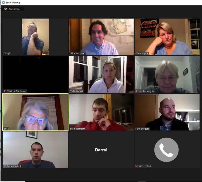
The Community Resilience Building workshop was held as a series of online Zoom meetings since in-person workshops
were not possible during the COVID-19 pandemic. Breakout groups were still possible in online meetings. (Source: Dodson
& Flinker)

Meanwhile, the core team and the consultants prepared for the Community Resilience Building
(CRB) workshop. The CRB workshop is the heart of the MVP planning process. The workshop is
typically one full-day session, or a series of shorter workshops. In this case, the COVID-19 pandemic
made in-person large gatherings impossible, so the team agreed on a series of online workshops
using Zoom. In preparation for the workshop, the project team gathered background information,
developed a schedule and agenda for the workshop, and recruited a group of invited stakeholders.
The project team developed a website to explain the project process, share background data and
maps, and solicit information from the community through a survey and interactive webmap. The
website is located at: https://storymaps.arcgis.com/stories/bf9095aa395441e68d0bd40fc6c4730e.

Screenshot from the project website

Hatfield CRB Workshop Summary of Findings                                                                            3
Stakeholders were selected to represent a variety of Town departments, boards, and committees,
as well as local businesses and regional organizations. See the full list of participants at the end of
this report.
The Community Resilience Building (CRB) workshops were held on October 19, October 26, and
November 2, 2020. The workshops followed a community-driven planning process that has been
tested and refined in dozens of communities throughout Massachusetts and beyond (see the CRB
Workshop guide available at www.communityresiliencebuilding.com).
The workshop’s central objectives were to:
    •    Define top local natural and climate-related hazards of concern
    •    Identify existing and future strengths and vulnerabilities
    •    Develop prioritized actions for the community
    •    Identify immediate opportunities to collaboratively advance actions to increase resilience.

The MVP planning process. Most of the process occurs during the CRB workshop.

The first workshop began with a presentation that explained the workshop process and
terminology, gave background information on climate change including watershed-level
projections of climate change in Massachusetts, described past climate-related natural hazard
events in Hatfield, and provided background information about Hatfield’s infrastructural, societal,
and environmental strengths and vulnerabilities. See the Appendix for the full presentation. The
presentation was followed by a group discussion of how climate change might influence natural
hazards in Hatfield and which hazards would be most important to evaluate. For the next hour,
participants worked to identify Hatfield’s top hazards using an online mapping application.

Hatfield CRB Workshop Summary of Findings                                                                 4
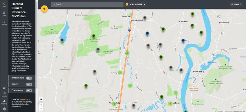
Online interactive map used during Hatfield’s MVP Workshop to gather information about Hatfield’s strengths,
vulnerabilities, and potential actions. Color coded pins indicate strengths and vulnerabilities identified by workshop
participants: gray for infrastructure, blue for society, green for environment.

After the first workshop, participants were asked to complete homework, identifying important
infrastructural, societal, and environmental features on a collaborative online mapping platform.
The locations of specific features could be pinned on the map, along with any associated notes.
Features that were non-location specific could be added as well.
During the second workshop, participants discussed the strengths and vulnerabilities that they had
started to identify, and added others using the shared online map. After the second workshop,
participants were again asked to complete a brief “homework assignment” by thinking of their
personal top action items or highest priority issues that should be identified through this project.
Participants were also given the opportunity to add any final items to the shared online map, and
to review and give input to the in-progress MVP matrix which was in a shared online spreadsheet.
The third online workshop began with a presentation about how to craft effective actions for
building local resilience, based on available climate change predictions, with a focus on nature-
based solutions (see the Appendix). Workshop participants then worked in small groups to
brainstorm and prioritize actions that could build on Hatfield’s strengths or mitigate its
vulnerabilities to climate change.
At the end of the third workshop, the full group assembled again. Each small group shared their
priority actions, as facilitators summarized them on moveable “stickies” on a shared screen using
the Stickies.io app. Actions were then arranged on screen and grouped into categories. The full
group discussed the priority actions and by the conclusion of the meeting had agreed upon a
ranking of the top five actions.

Hatfield CRB Workshop Summary of Findings                                                                           5
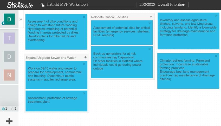
Screenshot of application used to group and prioritize action items during virtual workshop

This report captures the wealth of information and ideas that were generated during the CRB workshop.
It highlights the top hazards, the key infrastructural, societal, and environmental vulnerabilities and
strengths identified by workshop participants, and the key actions that Hatfield could take to build on its
strengths and, to the extent feasible, reduce its vulnerabilities.
This report incorporates comments from the MVP core team and input from community members
that attended a virtual listening session held on May 24, 2021 or provided comments on the public
review draft which was posted on the Town’s website.

Hatfield CRB Workshop Summary of Findings                                                                 6
3. TOP HAZARDS & VULNERABLE AREAS
Natural hazards are natural events that threaten lives, property, and other assets. Often, natural
hazards can be predicted. They tend to occur repeatedly in the same geographical locations
because they are related to weather patterns or physical characteristics of an area.
The Hatfield Hazard Mitigation Plan 2016 Update is Hatfield’s most recent approved hazard
mitigation plan. The 2016 hazard mitigation plan evaluated Hatfield’s risk from various hazards. It
concluded that the following are moderate risk hazards: flooding, severe snowstorms / ice storms,
dam failure, severe thunderstorms/ winds/ tornadoes, hurricanes/ tropical storms. It found the
following are low risk hazards: extreme temperatures, drought, wildfires/ brush fires. The plan did
not rate invasive species/ecosystem disruption—a hazard which is included in the latest
Massachusetts Integrated State Hazard Mitigation and Climate Adaptation Plan and in the MVP
plans of some western Massachusetts communities.

  Hazards According to Hatfield Hazard Mitigation Plan, 2016

The hazard risk evaluation above was the starting point for the assessment of hazards at the MVP
workshop. It was augmented by climate change projections provided by the MVP program,
information from the Massachusetts Integrated State Hazard Mitigation and Climate Adaptation
Plan about climate change and its interactions with natural hazards, and the knowledge, wisdom
and experience of Hatfield’s staff and citizens who participated in the process.

Hatfield CRB Workshop Summary of Findings                                                            7
At the CRB workshop, the group identified the following as top hazards that Hatfield faces:
    •    Flooding
    •    Severe storms (storms in all seasons)
    •    Ecosystem Disruption
    •    Average and Extreme Temperatures and Drought

    Priority Climate-Related Hazards for MVP Planning

         Flooding                   Severe Storms                  Ecosystem                  Average &
                                                                   Disruption                  Extreme
                                                                                           Temperatures and
                                                                                               Drought
Flooding, Severe Storms, Ecosystem Change, and Average and Extreme Temperatures and Drought are the town’s top
climate-related natural hazards according to participants in Hatfield’s MVP Workshop
(Sources, left to right: Flood by Iconathon US from Noun Project, Storm by Alexis from the Noun Project, Tree by Liane
Kirschner from the Noun Project, Temperature by Vectors Market from Noun Project)

Hatfield CRB Workshop Summary of Findings                                                                                8
Areas of Concern (Specific Locations) Workshop groups mapped specific locations where natural hazards may be particularly problematic. The locations of these strengths and vulnerabilities are shown below. The information is also available on a webmap at: https://dodsonflinker.maps.arcgis.com/apps/instant/minimalist/index.html?appid=442f6604871d4 3ca9fc6e2ac8803eab8. This webmap contains information about each location, including a description of the strength or vulnerability at that location, related hazards, and potential actions linked to the location. Map of climate-related strengths and vulnerabilities gathered during Hatfield’s MVP Workshops. View this map online at:https://dodsonflinker.maps.arcgis.com/apps/instant/minimalist/index.html?appid=442f6604871d43ca9fc6e2ac8803 eab8. Hatfield CRB Workshop Summary of Findings 9
Specific areas of concern include:
    •    Hatfield’s historic center, which is within the 500-year flood zone and contains critical Town
         facilities including Town Hall and the town’s historical records and archives, the police and
         fire stations, and the Capawonk Housing for the Elderly.
    •    Low lying areas throughout the town currently flood, see Infrastructure Vulnerabilities
         below.
    •    The bridge over the Mill River on Chestnut Street has an undersized box culvert. The bridge
         is in poor condition and routinely overtops during floods. Chestnut Street is a primary route
         in and out of the community—one of a handful that cross I-91.
    •    Flooding from the Mill River when the Connecticut River backs up into it.
    •    Agricultural ditches throughout the town. Some ditches are no longer maintained. The
         result is that areas that used to be drained are now flooding more frequently.
    •    Farmland throughout the town, which is comprised of some of the world’s highest quality
         agricultural soils.
    •    Route 5 & 10, the town’s primary commercial corridor and primary connection to
         communities north and south, would be impacted in the event of a dam failure upstream.
    •    Northampton Reservoir and Mountain Street Reservoir lie outside of Hatfield’s town lines,
         but lie uphill in watersheds that flow through Hatfield including across Route 5 & 10, posing
         a risk to Hatfield’s infrastructure in the event of a dam failure.
    •    Hatfield’s Connecticut River dike system protects much of the town from flooding. It is not
         known whether it is designed to handle larger storm events due to climate change.

Hatfield CRB Workshop Summary of Findings                                                              10
4. CURRENT CONCERNS AND CHALLENGES PRESENTED BY
HAZARDS AND CLIMATE CHANGE
Projected Changes in Hatfield’s Climate
To prepare for the future, Hatfield needs to know how the area’s climate may change over the
coming decades and how that will impact natural hazards. The workshop built on the following key
information resources: The Hatfield Hazard Mitigation Plan 2016 Update, the 2018 Massachusetts
State Hazard Mitigation and Climate Adaptation Plan, and “Massachusetts Climate Change
Projections” by Northeast Climate Science Center at the University of Massachusetts.
Climate Change Projections for the Connecticut River Basin from the Northeast Climate Science Center at the University
of Massachusetts (Source: Resilientma.org,
http://resilientma.org/datagrapher/?c=Temp/basin/maxt/ANN/Connecticut/)
Although there is uncertainty about how rapidly the climate will change over the coming decades
or how extreme the results will be, we do know the general direction of climate change. From that
we can generally predict how climate change will influence natural hazards. We know that annual
air temperatures in the Northeast have been warming at an average rate of 0.5°F (nearly 0.26°C)
per decade since 1970. Winter temperatures have been rising at a faster rate of 0.9°F per decade
on average. 3 Between 1991-2012 there has been an average of 10 more frost-free days per year
than between 1901-1960. The increases in temperature are projected to accelerate over the
coming decades. Climate projections for the Connecticut River Watershed that were produced by
the Northeast Climate Science Center at the University of Massachusetts predict that by the 2050s:
3
Northeast Climate Adaptation Science Center, “Massachusetts Climate Change Projections.”
Hatfield CRB Workshop Summary of Findings 11• Average annual temperature will rise
6.4°F (6-13%) Potential impacts of increased
temperatures: a longer growing
• Average winter temperatures will rise season, more vector-borne diseases,
from 25° to 28-33°
increased cooling costs and
• Summer and Fall will see the biggest decreased heating costs, more
maximum temperature increases (2.8°- invasive species, disruption of
7.5° and 3.8°-13.4° respectively)
ecosystems and natural processes.
Along with higher average temperatures there will also be more extremely hot days. By mid-
century, Hatfield may experience the following increases in extremely hot days:
• Days Over 90°F: from 6 days to 16-41 days Potential impacts of extreme heat:
per year increased risk for heat stroke, bigger
• Days Over 95°F: FromWinter may bring more crippling snowstorms, more ice storms, winter flooding due to rapid thaws or rain on frozen ground, and decreased snowpack. These changes will impact daily life, the lifecycle of plants and animals, stream flow, water levels in lakes and reservoirs, groundwater recharge, and drinking water supplies, etc. Spring, summer, and fall may bring more extreme temperatures, larger and more frequent tropical storms and hurricanes, thunderstorms, tornados, and microbursts. While the growing season may be extended, unpredictable weather events like drought, intense storms, or sudden cold snaps can damage crops and pose serious challenges for farming in Hatfield. These larger storm events may exceed the design-capacity of some of Hatfield’s road and stormwater infrastructure which were designed for more moderate events. For houses on septic systems, episodes of elevated ground water levels could inundate leach fields or cause septic tanks to ‘float’. Larger storm events may result in erosion and may reduce the ability of natural systems to cleanse and infiltrate stormwater which could reduce aquifer recharge and impact water quality. Already, some other communities have decided to consider the 500-year flood plain the new 100- year flood plain. Hatfield’s town center lies within the 500-year floodplain, which includes Town Hall, most of the Town archives, police and fire stations, and the Capawonk Housing for the Elderly. Impacts of Climate Change on Hazards in Hatfield The Town of Hatfield has been impacted by many natural hazards over the years. Flooding has been one of the most recurring events. The Great Flood of 1936 severely impacted much of the Connecticut River valley when an unusually snowy winter was followed by a period of warm and rainy weather. Hatfield was hit hard by the ensuing flooding, as flood waters destroyed barns and houses and flooded farm fields. The Hatfield Dike, an earthen levee along the town’s southeastern bank of the river, was constructed in 1938, and flooding at this scale has not occurred since. Localized flooding is still a regular issue in Hatfield. Mill River flooding in 2005 and 2014 submerged Chestnut Street, temporarily blocking an important east-west connection within the town. Fields around South Street and Valley Street flood frequently during heavy rain events. And in May 1984 a period of prolonged rain caused such extensive flooding that Elm Street was the only main road in town not impacted by flooding. Future weather patterns are likely to bring more frequent heavy rain events to the Northeast, and the kind of flooding Hatfield has regularly experienced is likely to increase. Workshop discussions also took into consideration the possibility of larger scale flooding from the Connecticut River, and the impact this would have on critical town facilities, farmland, and infrastructure. Flood waters from the Connecticut River overtop the dikes or could back up into the town by entering through the low point where the Mill River cuts through the dike and meets the Connecticut River. Ecosystem disruption, extreme temperatures and prolonged droughts have fewer historical precedents in Hatfield, but are likely to become very significant factors impacting the town, especially its farms. These stresses will likely test the resilience of farms in the area and will highlight the importance of farming methods that promote biodiversity, soil health, water conservation, reduced or eliminated dependence on chemical applications, holistic management, and other climate resilient practices. Climate-resilient farming practices will not only protect the Hatfield CRB Workshop Summary of Findings 13
rich asset of Hatfield’s high-quality farmland, but will also sequester atmospheric carbon, enabling
Hatfield to lead the way in not just climate adaptation but also climate change mitigation.
Workshop participants reported that some of Hatfield’s farmers are already adapting to climate
change.
Workshop participants also discussed the possibility of increased development in Hatfield due to
climate change. Climate disruptions elsewhere may lead climate refugees to move to communities
like Hatfield, which would lead to increased development, increased development pressure on
unprotected farmland, and increased demands on the town’s infrastructure.

Key Hazards

                     Flooding: Flooding was cited as a top concern by workshop participants. Flooding
                     will impact roads, farm fields, low lying areas, and areas near poorly maintained
                     agricultural ditches. More severe flood events could impact specific areas such as
                     the Route 5 & 10 corridor if the Northampton Reservoir and Mountain Street
                     Reservoir overtopped, or the town’s historic center and municipal facilities in the
                     event of a 500-year flood. Flooding can also damage homes and businesses,
                     dislocate people, increase water contamination and water-borne illnesses, and
                     result in illness from mold exposure after flood waters recede. 4,5 The network of
                     agricultural ditches, wetlands and stream corridors throughout Hatfield can help
                     mitigate flood severity if properly managed.

                     Severe storms (all seasons): Between 1958-2012, the Northeast experienced a
                     71% increase in precipitation that falls as part of a heavy precipitation event. 6
                     Severe storms create the risk of flood events, as highlighted above. They also can
                     cause: falling or flying objects—resulting in injuries and damage to property;
                     damage to roads—resulting in motor vehicle accidents and delayed emergency
                     response; damage to water and sewer/septic infrastructure—resulting in water
                     contamination and water-borne illnesses; 7 and power outages—resulting in
                     increased falls and injuries in homes, carbon monoxide poisoning from improper
                     use of generators or heating devices, and loss of power to life-sustaining medical
                     devices. 8 Severe storms are particularly threatening to the elderly, people living
                     alone, people with limited mobility, people with limited English proficiency,

4
  American Public Health Association, “How Climate Change Affects Your Health.”
5
  Massachusetts Department of Public Health, Bureau of Environmental Health, “Climate and Health Pathways |
MEPHT.”
6
  “National Climate Assessment.”
7
  American Public Health Association, “How Climate Change Affects Your Health.”
8
  Massachusetts Department of Public Health, Bureau of Environmental Health, “Climate and Health Pathways |
MEPHT.”

Hatfield CRB Workshop Summary of Findings                                                                     14
people with chronic diseases, or compromised immune systems, children under
five years old, and people who use electrically powered medical devices. 9
Average and Extreme Temperatures, Drought: Current trends indicate that the
climate in New England is steadily warming, with more extremes in both rainfall
and drought. On average, the Northeast experienced 10 more frost-free winter
days between 1991-2012 than it did from 1901-1960. 10 Current trends indicate
there will be increasingly more days per year above 90 in the coming decades. 11
Older adults, children, and people with low incomes are especially vulnerable to
heat related illness and death, including heat stroke, dehydration, aggravated
cardiovascular disease, and aggravated respiratory disease. 12
Ecosystem Disruption: Hatfield is fortunate to have large areas of forest,
wetlands, and water bodies, that provide wildlife habitat, ecosystem services,
recreational opportunities, and quality of life benefits for its residents. Changing
temperature and precipitation patterns may stress or degrade these ecosystems.
Climate change may worsen the impact of pests, such as the Hemlock Woolly
Adelgid and, Emerald Ash Borer, and blights, such as beech bark disease. Heat
and drought will stress agricultural crops, native plant species, and wildlife. In
addition, heightened storm frequency and intensity increases the potential for
destructive wind or ice storms to damage trees. Broadscale change in Hatfield’s
ecosystems would threaten numerous native species and key qualities that make
the town what it is. Direct impacts on humans include the potential for increased
risk of vector borne illness, fires, crop damage, and infrastructure damage from
weakened or downed trees.
9
Massachusetts Department of Public Health, Bureau of Environmental Health.
10
“National Climate Assessment.”
11
Northeast Climate Adaptation Science Center, “Massachusetts Climate Change Projections.”
12
American Public Health Association, “How Climate Change Affects Your Health.”
Hatfield CRB Workshop Summary of Findings 15Hatfield CRB Workshop Summary of Findings 16
Map of FEMA Flood Zones.

5. SPECIFIC CATEGORIES OF CONCERNS AND CHALLENGES
Infrastructural Vulnerabilities
Roads and Culverts
Climate change could damage roads through the following: larger storm events could cause road
erosion, washouts, and blockages and damage from downed trees and power lines; increased
erosion due to rain that follow periods of drought (rain on dry soil is more likely to run off than rain
on moist soil); more frequent freeze-thaw cycles; extreme heat can soften asphalt leading to
rutting and subsidence. 13 14 15
The map shown below displays the structural rating of bridges (squares) and culverts (circles) in
Hatfield. Two bridges on I-91 at the south end of Hatfield are rated as structurally deficient by
MassDOT. None of the culverts that have been evaluated are rated as structurally deficient.
Culverts (diamonds) can also be a barrier to the movement of aquatic species. Eight culverts along
the Running Gutter have been evaluated for wildlife barriers. Of those, one is a severe barrier and
four are moderate barriers.
The majority of culverts (purple diamonds) in Hatfield have not been evaluated for either structural
deficiency or wildlife connectivity.
     •   Participants at the CRB Workshop shared numerous locations where low-lying roads or
         undersized culverts risk road flooding. Examples include:
             o Maple Street flooding from the Mill river
             o Bridge on Chestnut Street
             o Main St’s low-lying areas
             o North Street and King St’s low-lying areas
             o Jericho Road
             o Cronin Hill Road
             o Depot Road
             o The bridge over the Mill River on Chestnut Street has an undersized box culvert. The
               bridge is in poor condition and routinely overtops during floods.
             o Culvert on Cow Bridge Road
             o Maple Street area could flood from Mill River

13
   “TechBrief: Climate Change Adaptation for Pavements, FHWA-HIF-15-015.”
14
   “MA Climate Change Clearinghouse.”
15
   Meyer and Weigel, “Climate Change and Transportation Engineering.”

Hatfield CRB Workshop Summary of Findings                                                             17
• Hatfield relies on Route 5&10 as its primary connection to surrounding communities.
While flooding here has not regularly occurred, a flood large enough to cover this route
would cause great damage throughout the town while blocking the most critical
emergency evacuation route out of Hatfield. Such flooding could potentially be caused
by dam failure or overtopping from one of the reservoirs upstream.
Map of known culverts and bridges in Hatfield
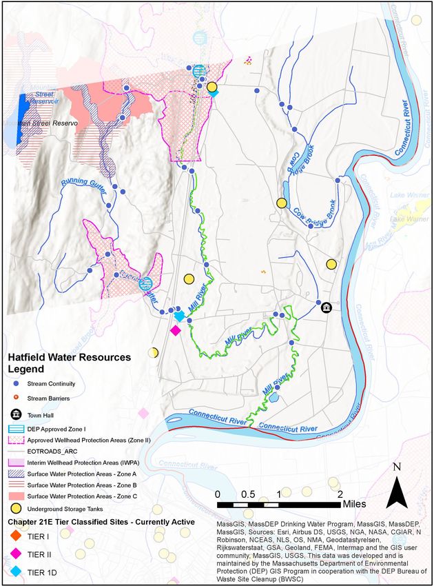
Hatfield CRB Workshop Summary of Findings 18Dams and Flood Control Upstream in the Mill River watershed are the eastern dike for the Mountain Street Reservoir and the dam for the Northampton reservoir. Although these reservoirs are located in Williamsburg and Whately (respectively), flooding from overtopping of these structures would pass through Hatfield and cause significant impacts throughout the town since the Mill River passes through the middle of Hatfield geographically. The Mountain Street Reservoir dike sits just over the town line, in Hatfield. The D.F. Riley Grist Mill Dam on the Mill River near Prospect Ct is privately owned and is rated a "Significant Hazard” by the Massachusetts Office of Dam Safety. These hazard potential ratings indicate how likely failure of the dam would lead to loss of life, damage to property, or interruption of important services. The ratings do not indicate likelihood of failure or structural integrity. Hatfield’s most significant flood control structure is the Hatfield Dike along the town’s southeastern bank of the Connecticut River. Since its construction in 1938 this earthen levee has had to be maintained, but it has prevented Connecticut River flooding from reaching into the town. The dike is under the control of the US Army Corps of Engineers. Participants at the CRB workshop said the Mill River frequently backs up due to water from the Connecticut River. Participants also questioned whether a break in the levee near the Mill River poses a possibility of Connecticut Rover floodwaters of ever backing up into the town from the south. Workshop participants were also unsure of the extent of protection the dike provides as it moves farther north. On a smaller but very extensive scale, agricultural ditches were historically constructed by farmers along the edges of fields as a flood control system, allowing farmers to then alter the landscape for Hatfield CRB Workshop Summary of Findings 19
agricultural use without resulting in frequent flooding. Over time, as land has transitioned from
farming to other uses, landowners have often been unaware of the function of these drainage
ditches, or have been unable to maintain them due to wetlands regulations. As these ditches are
abandoned the frequency of localized flooding increases. Hatfield has relatively flat topography
with ample low lying land. The town does not have a comprehensive plan for assessing the long
term impacts of the abandonment of drainage ditches or for managing stormwater as land
transitions from drained agricultural uses to non-farm uses.

Critical Facilities, Town Facilities, Town Equipment
The town center of Hatfield is located within the 500-year flood zone. Critical facilities here include
the town hall, town records and historical archives, emergency management including the police
and fire stations and associated vehicles, the library, elementary school, emergency shelter, and an
elderly assisted care facility. The area also includes the historic architecture of Hatfield’s oldest
buildings. Some communities treat the 500-year floodplain as the new 100-year floodplain in
climate change preparedness planning. In any scenario, the chance of Hatfield’s town center
flooding is only going to increase. The present concentration of critical facilities here means that in
the event of a very large flood, much of the Town’s hazard response infrastructure would itself be
underwater, compounding the severity of what would already be a significant disaster.

Utilities and Energy Supply
The large forested area of western Hatfield is one of the town’s many great assets, but trees risk
falling on power lines if not properly maintained. Severe storms and climate-related disruptions to
ecosystem health will increase the chances of this happening. Individual houses on well water
throughout west Hatfield could lose both water and electricity in the event of a power outage.

Wastewater
About half of the town is connected to a municipal sewer system. Hatfield’s wastewater treatment
plant is located in the northeast part of town close to the Connecticut River, in an area within the
current 500-year floodplain that has flooded historically. While the facility itself hasn’t been
impacted by flooding during its existence, the risk of the water treatment plant flooding will
increase as severe weather becomes more frequent.

Drinking Water
Hatfield’s drinking water comes from three sources: the Hatfield Town reservoir, also known as the
Running Gutter Brook Reservoir; the Omasta Well; and the West Hatfield Well. While these water
supply sources were not greatly emphasized during the CRB workshop, they would be somewhat
vulnerable to added demand from increased development and prolonged periods of drought and
should continue to be protected from water contamination.

Hatfield CRB Workshop Summary of Findings                                                            20
Hatfield CRB Workshop Summary of Findings 21
Chemical Facilities
The Helena Chemical company’s facility is located just above grade of the 500-year floodplain. Even
though it is just out of the floodplain, flood waters would come very close to the facility in a 500-
year flood, and flooding of this chemical storage facility would have serious consequences.
Similarly, Turf Care Supply on Dwight St is not within the floodplain but is near the 500-year
floodplain of the Mill River. Precautions should be taken at both chemical facilities to prevent
flooding from causing a chemical spill.
Hazardous materials are carried on both I-91 and the railroads through Hatfield. A spill on either of
these corridors could have far reaching impacts in Hatfield, especially if the spill occurred within
the wellhead protection area in the northern part of the Town.

Societal Vulnerabilities
Vulnerable Populations
Oak Ledge, a 55 and older community of trailer homes on Route 5/10 in West Hatfield serves as an
informal retirement community, according to some participants at the CRB workshop. As this
housing is relatively inexpensive compared to other housing in the Town, it potentially contains a
concentration of residents who many not have the resources to prepare for, or respond to, the
impacts of climate change especially severe storms and extreme temperature. This area is not
within the 500-year floodplain, but residents may still be impacted by disruptions caused by
flooding elsewhere in Hatfield, including transportation disruptions and loss of power. In addition,
the part of Hatfield has some apartments whose residents may have lower incomes than the
average for Hatfield. If so, these residents may be more vulnerable to the impacts of climate
change—this could be explored further through direct outreach to these residents.
More vulnerable is the Capawonk Housing for the Elderly. These income-restricted apartments for
older adults are located in the center of Hatfield which is within the 500-year flood plain. In
addition to the flood risk here, the facility does not have a generator and is vulnerable to power
outages. This is a serious vulnerability since some residents depend on electricity for medical
equipment.

Emergency Shelters and Communication
The Smith Vocational School in Northampton serves as a backup and overflow shelter.
Cell phone coverage in the center of Hatfield is considered poor. This would make communication
during a hazard difficult.

Community, Connectedness, and Social Networks
Hatfield benefits by having many long-term residents who call this town home, which results in
strong community ties that people can call on when the town faces challenges. This community
connectedness can be an asset in building hazard preparedness. At the same time, CRB workshop

Hatfield CRB Workshop Summary of Findings                                                           22
participants pointed out that Hatfield is gradually losing school-age children, since young families
have not been able to easily move here due to limited housing and slow housing turnover.
Hatfield’s center consists of historic architecture typical of the area’s earliest colonial history,
contributing to the town’s sense of identity. The possibility of flooding through this area puts these
structures at risk.

Housing
Hatfield’s zoning requires large lot sizes (45,000-60,000 square feet depending on district). This
may slow the creation of new housing and increase its cost. This makes it difficult for young people
and new residents to find homes in Hatfield, or for older adults to downsize and relocate within
Hatfield. Overtime, this may result in a loss of population, erode community cohesion, and
threaten the Town’s school enrollment, due to insufficient enrollment.

Agriculture and Food Supply
The farmland in Hatfield is rich Connecticut River valley bottom land, and Hatfield’s soil in
particular is considered some of the best agricultural soil in the world. While some farmland in
Hatfield is under Agricultural Preservation Restriction, much of it remains unprotected, due in part
to many small parcels not qualifying for APR. As populations shift due to climate migration, Hatfield
should be prepared for the possibility of increased development pressures and continue efforts to
protect as much of this irreplaceable farmland as possible.
Even when protected against development, farm soil itself is a fragile resource than can be
degraded or lost through conventional farming practices. Increased flooding and drought will only
intensify the rate of soil erosion unless care is taken to protect soil using to-till agriculture and
other climate resilient practices. As an added bonus, agricultural practices that prioritize soil health
tend to sequester atmospheric carbon, allowing a climate resilience measure to double as climate
change mitigation. In aggregate, “carbon farming” could be a key strategy in slowing and reversing
climate change globally, and with the right assistance Hatfield’s farms could play an important role
in slowing climate change while protecting themselves from its effects. 16
Changing temperatures and weather patterns and shifting species distributions will pose new
challenges to farmers in Hatfield. Farmers may need assistance transitioning to more climate
resilient, integrated, and biodiverse practices in order to build soil moisture retention, incorporate
greater biodiversity in their crops, manage increased pest pressure, and other climate resilient
practices. Farmers often exist with slim margins for error, and the immediate financial risk of
adopting new practices can outweigh the potential long-term benefits. For farms in Hatfield to
adjust to the demands of climate change, some coordinated assistance to farmers will likely be
necessary.

 Kittredge, Jack “Soil Carbon Restoration: Can Biology do the Job?” Northeast Organic Farming Association/
16

Massachusetts Chapter, Inc.

Hatfield CRB Workshop Summary of Findings                                                                    23
Farmers in Hatfield are well supported already by the Town and the community, and this support
should be continued and enhanced for adapting to the area’s future climate. Farming in Hatfield is
not only important to the food supply and economy of the region, it is a central piece of Hatfield’s
identity as a town.

Environmental Vulnerabilities

Rivers, Ponds, and Wetlands
The Connecticut River has flooded in the past, most notably in 1936 (prior to construction of the
Hatfield dike) when flood waters caused significant damage to homes and farms throughout most
of the town. The levees that currently protect the town may not be designed for the scale of storms
that could occur in the future and should be evaluated.
Great Pond, which is an important natural resource and home to a variety of wildlife, is adjacent to
the Hatfield transfer station and materials storage facility. While these facilities are not within the
500-year flood plain, they are located on top of a bank perched immediately above the pond and
flood plain, and bank erosion, storm damage to the facilities, or exceptionally severe flooding could
cause materials from these facilities to contaminate floodwaters.

Forests
Some of Hatfield’s open forested and aquatic lands are not protected from development (except by
wetland restrictions). To further build a resilient landscape in Hatfield, the town should continue to
conserve key properties that strengthen and expand existing ecological networks.
Forests in the town should be properly managed to prevent wildfires, protect water resources, and
strengthen ecological resilience. This includes Town-owned forest land as well as riparian forest
buffer land managed by farmers and private landowners.

Conservation
West Hatfield is hilly and forested and contains transitional landscape from river to uplands. This
area forms a key link in the wildlife corridor between Fitzgerald Lake in Northampton and the
White Rock area to the north and should be further protected from development in order to
strengthen the region’s ecological resilience. In addition, selected land near the Connecticut River is
a conservation priority. The second map below shows existing open space by level of protection in
Hatfield overlaid on data from Mass Audubon's Mapping and Prioritizing Parcels for Resilience
(MAPPR) tool. MAPPR shows parcels that are a priority for conservation based on a variety of
factors including proximity to existing protected land, climate resilience, priority habitat, etc.
MAPPR’s “Balanced Model” is shown here.

Hatfield CRB Workshop Summary of Findings                                                            24
Hatfield CRB Workshop Summary of Findings 25
Hatfield CRB Workshop Summary of Findings 26
Vector Borne Diseases
Shorter winters will likely lead to an increase in tick populations as favorable conditions for their
host species (deer, mice) expand. This may lead to an increase in tick-borne diseases like Lyme,
babesiosis, and ehrlichiosis.

Hatfield CRB Workshop Summary of Findings                                                               27
6. CURRENT STRENGTHS AND ASSETS
Infrastructural Strengths
Transportation
    •    The town is bisected by Interstate 91 and Route 5 & 10. This gives Hatfield excellent
         connectivity to the region, especially to points north and south (Northampton, Springfield, I-
         90, and Connecticut to the south; Greenfield, Route 2, Vermont to the north).
    •    The town is bisected by railroad running north-south along the I-91/Route 5 & 10 corridor,
         allowing the potential for freight and passenger train stops. The C&S Grocers facility comes
         alongside the railroad and has its own railroad spur.

Housing
    •    Workshop participants report that Hatfield’s housing stock is mostly in well maintained, and
         many residents can afford to prepare for climate change hazards at the home level—for
         example, by installing air conditioning or a backup generator.

Societal Strengths
Emergency Services
    •    Smith Vocational School in Northampton is the regional shelter. This facility is adequately
         sized for Hatfield’s needs.

Community
    •    Hatfield is home to many long-term residents who know the town and the community well.
         This builds a strong sense of community cohesion in Hatfield, which offers an opportunity
         for community generated activities such as preparedness.

Agriculture
    •    Hatfield’s geographic setting in the Connecticut River valley floodplain has given it some of
         the highest quality agricultural soils in the world. Farming is an important part of Hatfield’s
         economy and cultural identity.
    •    Town residents and town government have shown strong support for Hatfield’s farmers, by
         reducing water supply rates for farmers, helping place Agricultural Preservation Restrictions
         on farmland, publishing an annual brochure of local farms, purchasing products from local
         farms, etc.
    •    Riquezas del Campo is a community farm in Hatfield that contributes to the food
         distribution network for vulnerable communities.
    •    The Food Bank of Western Massachusetts has its main distribution center in Hatfield. This
         organization provides a very important service to the region by distributing food to people
         in need.

Hatfield CRB Workshop Summary of Findings                                                              28
Environmental Strengths
Water Resources
• The Connecticut River is a significant natural and recreational resource for Hatfield.
• Ponds and wetlands throughout the town provide important wildlife habitat.
Forests
• Forested land in west Hatfield protects the quality of Hatfield’s drinking water sources while
providing a natural and recreational resource for Hatfield.
• Much of this forested land in west Hatfield forms a key linkage between the Fitzgerald Lake
Conservation area to the south and the White rock area and beyond to the north.
• Riparian forests along the Connecticut River and Mill River protect these water bodies from
agricultural runoff including excess nutrients and sedimentation.
Soils
• As mentioned previously under “agricultural strengths”, the agricultural soil is Hatfield is of
extremely high quality and should be treated as a rare resource to be protected and
enhanced. This is one of the main reasons why agriculture has been able to thrive in
Hatfield.
Hatfield CRB Workshop Summary of Findings 297. TOP RECOMMENDATIONS TO IMPROVE RESILIENCE TO
HAZARDS
Participants in the Community Resilience Building workshop identified dozens of potential actions
to improve Hatfield’s climate resilience. During the CRB workshop, workshop participants
prioritized potential action and whittled them down to a smaller collection of top items. These
priorities were reviewed during the Listening Session held on May 24, 2021. The top
recommendations are described in detail below including recommended next steps, where
appropriate. These are followed by lists of other recommended actions, which are organized by the
workshop’s three categories of infrastructural, societal, and environmental action items and
classified into highest, moderate, and lower priority. The full list of recommended actions is
included in the compiled matrix in the Appendix.
The top actions identified through the CRB workshop and listening session are:
• Assess Conditions Along Connecticut River Dike and at the Wastewater Treatment Plant
• Plan for Relocation of Town Center Critical Facilities out of the Floodplain
• Conduct a Town-Wide Drainage and Stormwater Study and Strategy
• Incentivize Climate Resilient Farming
• Plan for Future Climate-Resilient Development
• Create a Climate Resilient Master Plan
Assess Conditions Along the Connecticut River Dike and at the Wastewater
Treatment Plant
The top priority identified at the workshop is a comprehensive analysis of Hatfield’s Connecticut
River flood protection system. The dike is under the control of the US Army Corps of Engineers and
any studies on the dike performed by the ACOE should be reviewed along with an assessment of
conditions of any other flood control structures. All of the town’s flood protection structures
should be mapped, including contour lines of potential flood elevations as they relate to dike
elevations. Hydrological modeling should be performed to illustrate future flooding scenarios, and
critical points or contour lines where flood waters may enter the town should be identified (even if
these lie along the Mill River or outside of the town’s boundaries). Ownership and management of
each flood control structure should be identified. From this analysis, additional needs or actions
should be identified based on the current state of the town’s flood control structures and the
protection requirements against larger climate-change driven floods.
Flood control structures vary along the length of Hatfield’s Connecticut River edge. The Hatfield
Dike is an earthen levee built in 1938. According to Hatfield’s Hazard Mitigation Plan, ongoing
maintenance and repair is important for the proper functioning of the dike. In 2011 the Town
received funding to re-surface the toe of the dike. It was not clear to the stakeholder group at the
workshop how (or whether) the dike protects against flooding around its southern end where the
dike ends and the low-lying Mill river cuts through the topography to meet the Connecticut River.
Hatfield CRB Workshop Summary of Findings 30The question was raised whether Connecticut River flood waters might ever back up into Hatfield via this cut in the dike’s topography. This stood out as a significant concern. From this study, a list of priority actions should emerge. While it is already known that the town center lies between the 100-year and 500-year floodplain, the circumstances leading to that flood event could be better understood and protected against—or conversely, new priorities might emerge for relocation of critical infrastructure. A plan could be developed to prepare for the event of dike failure or overtopping. Infrastructural improvements could be identified, for possible coordination with the Army Corps of Engineers. As part of this plan, flood protection for the Town’s wastewater treatment plant along the Connecticut River should be examined, and improvements to its flood protection should be implemented. This would help Hatfield, and downstream communities, avoid the kind of damage that was caused when Hurricane Irene flooded Greenfield’s wastewater treatment facility. Increased protection of the wastewater treatment plant could be paired with protection and restoration of floodplain forests and wetlands on adjacent parcels. These parcels are rated as a very high priority for conservation by Mass Audubon. This action item was given the highest priority because, among other important reasons, it will help determine the urgency of completing the next action item: relocating critical facilities from the town center out of the 500-year flood plain. Plan for Relocation of Town Center Critical Facilities out of the Floodplain A top concern among workshop participants was that the town center of Hatfield is located in the 500-year floodplain, and with the increasing frequency and severity of large storms, the chances of this storm event occurring will only increase. The town center includes the following critical facilities: Town Hall, Town historical records and archives, police department, fire department, Capawonk Housing for the Elderly, post office, and Hatfield Elementary School. While the historical architecture of the current town center will remain in place, critical infrastructure vital to the town’s functioning and emergency response should be considered for relocation. Potential sites should be identified where the town’s servers, files, historical archives and other critical data can be safely located away from flood risk. This could include finding a location for an altogether new Town Hall. Likewise, this new location should include the police and fire departments, since an emergency event like a 500-year flood is exactly the kind of situation where the town’s emergency responders would need to be mobilized; in its current location, the town’s emergency response infrastructure would itself be a victim of the flooding. The Capawonk Housing for the Elderly is also in the town center and in the 500-year flood plain and should be considered for relocation as well. In the short term, this facility needs backup generators because many of its residents rely on medical equipment, making power outages especially dangerous for them. This action item could potentially be coordinated with another of the top action items, “prepare for future climate-resilient development”, as a combined planning effort. In any case, the outcome of this action would be an analysis of infrastructure, flood risk, and available land to designate for a Hatfield CRB Workshop Summary of Findings 31
new Town facilities center. Again, whether and how to complete this action item will be informed
by findings of the flood protection assessment described above.

Conduct a Town-Wide Drainage and Stormwater Study and Strategy
Hatfield should inventory and asses agricultural ditches, culverts, and low-lying areas as one
connected system, and develop a town-wide strategy for drainage, stormwater management, and
farmland protection. Drainage ditches were constructed on Hatfield’s farm fields generations ago.
They move stormwater off the fields, into waterways, and ultimately into the Connecticut River.
Over generations, the people of Hatfield relied on these drainage ditches to move water along and
prevent flooding. They were able to farm, and later develop, land that would otherwise have been
wet. However, CRB workshop participants shared that, in recent years, many of these agricultural
drainage systems have been neglected. Drainage tile may be broken. Ditches are silting in and
becoming overgrown with vegetation. This is leading to localized flooding in places that previously
stayed dry. Areas with localized flooding identified at the CRB workshop include farms near the
wastewater treatment plant and loading docks at commercial facilities in low lying areas.
Maintenance of agricultural ditches is allowed under the Massachusetts Wetlands Protection Act,
but when farming ceases, it may no longer be allowed. The result is that some of Hatfield’s land is
becoming unsuitable for the uses it has been put to, like housing or commercial development.
Property owners may be unaware of the cause of their land becoming wet and may be unable to
shoulder the financial burdens that may result.
The Town needs an assessment of which lands are likely to become wet over time and which uses
will no longer be suitable. The Town also needs a strategy for assisting current and prospective
property owners with evaluating the impacts of the transition and preparing for it.
Meanwhile, like communities across the commonwealth, Hatfield has numerous culverts and
stormwater facilities that may be undersized in the face of climate change. The town needs a
systematic inventory and assessment of these facilities and a plan for upgrading them, as needed.
This study should include consideration of the use of nature-based solutions for managing
stormwater. It could also include a review of Hatfield’s bylaws and regulations related to
stormwater management and low impact development, including the zoning bylaw and subdivision
regulations.
This study should be conducted at a town-wide level and implemented in collaboration with
farmers, landowners, and the conservation commission, in order to alleviate the risk of localized
flooding in a way that also protects the town’s water quality and aquatic resources and helps it
prepare for climate change. As agricultural runoff into waterways is an important concern, the
evaluation of drainage ditches could be conducted in coordination with the next action item:
incentivizing climate resilient farming.

Hatfield CRB Workshop Summary of Findings                                                             32
You can also read