Validation of the Sentinel-5 Precursor TROPOMI cloud data with Cloudnet, Aura OMI O2-O2, MODIS, and Suomi-NPP VIIRS - eLib
←
→
Page content transcription
If your browser does not render page correctly, please read the page content below
Atmos. Meas. Tech., 14, 2451–2476, 2021
https://doi.org/10.5194/amt-14-2451-2021
© Author(s) 2021. This work is distributed under
the Creative Commons Attribution 4.0 License.

Validation of the Sentinel-5 Precursor TROPOMI cloud data with
Cloudnet, Aura OMI O2–O2, MODIS, and Suomi-NPP VIIRS
Steven Compernolle1 , Athina Argyrouli2,3 , Ronny Lutz3 , Maarten Sneep4 , Jean-Christopher Lambert1 ,
Ann Mari Fjæraa5 , Daan Hubert1 , Arno Keppens1 , Diego Loyola3 , Ewan O’Connor6,7 , Fabian Romahn3 ,
Piet Stammes4 , Tijl Verhoelst1 , and Ping Wang4
1 Atmospheric Data Synergies, Atmospheric Reactive Gases, Royal Belgian Institute for Space Aeronomy (BIRA-IASB),
Ringlaan 3, 1180 Uccle (Brussels), Belgium
2 TUM Department of Civil, Geo and Environmental Engineering, Chair of Remote Sensing Technology,

Technical University of Munich, Munich, Germany
3 Atmospheric Processors, Remote Sensing Technology Institute, German Aerospace Center (DLR), Münchener Straße 20,

82234 Weßling, Germany
4 Research and Development Satellite Observations, Royal Netherlands Meteorological Institute (KNMI), Utrechtseweg 297,

3730 AE De Bilt, the Netherlands
5 Atmospheric and Climate Research, Norsk Institutt for Luftforskning (NILU), Instituttveien 18, 2007 Kjeller, Norway
6 Finnish Meteorological Institute (FMI), Helsinki, Finland
7 Department of Meteorology, University of Reading, Whiteknights, P.O. Box 217, Reading,

Berkshire RG6 6AH, United Kingdom

Correspondence: Steven Compernolle (steven.compernolle@aeronomie.be)

Received: 22 May 2020 – Discussion started: 29 June 2020
Revised: 25 January 2021 – Accepted: 1 February 2021 – Published: 31 March 2021

Abstract. Accurate knowledge of cloud properties is              mean latitudinal variation of S5P cloud properties is similar
essential to the measurement of atmospheric composition          to that of other satellite data. S5P OCRA/ROCINN_CAL
from space. In this work we assess the quality of the cloud      agrees well with NPP VIIRS cloud-top height and cloud
data from three Copernicus Sentinel-5 Precursor (S5P)            optical thickness and with Cloudnet cloud-top height,
TROPOMI cloud products: (i) S5P OCRA/ROCINN_CAL                  especially for the low (mostly liquid) clouds. For the high
(Optical Cloud Recognition Algorithm/Retrieval of Cloud          clouds, S5P OCRA/ROCINN_CAL cloud-top height is
Information using Neural Networks;Clouds-As-Layers),             below the cloud-top height of VIIRS and of Cloudnet, while
(ii) S5P OCRA/ROCINN_CRB (Clouds-as-Reflecting                   its cloud optical thickness is higher than that of VIIRS.
Boundaries), and (iii) S5P FRESCO-S (Fast Retrieval              S5P OCRA/ROCINN_CRB and S5P FRESCO cloud height
Scheme for Clouds from Oxygen absorption bands –                 are well below the Cloudnet cloud mean height for the
Sentinel). Target properties of this work are cloud-top          low clouds but match on average better with the Cloudnet
height and cloud optical thickness (OCRA/ROCINN_CAL),            cloud mean height for the higher clouds. As opposed
cloud height (OCRA/ROCINN_CRB and FRESCO-S),                     to S5P OCRA/ROCINN_CRB and S5P FRESCO, S5P
and radiometric cloud fraction (all three algorithms). The       OCRA/ROCINN_CAL is well able to match the lowest
analysis combines (i) the examination of cloud maps for          CTH mode of the Cloudnet observations. Peculiar geograph-
artificial geographical patterns, (ii) the comparison to other   ical patterns are identified in the cloud products and will be
satellite cloud data (MODIS, NPP-VIIRS, and OMI O2 –O2 ),        mitigated in future releases of the cloud data products.
and (iii) ground-based validation with respect to correlative
observations (30 April 2018 to 27 February 2020) from the
Cloudnet network of ceilometers, lidars, and radars. Zonal

Published by Copernicus Publications on behalf of the European Geosciences Union.
2452                                                       S. Compernolle et al.: Validation of S5P/TROPOMI cloud products

1   Introduction                                                     distribution, and their horizontal patterns. Since GOME, all
                                                                     UV/VIS nadir sounders with the exception of OMI have in-
For decades the global distribution of atmospheric con-              cluded measurements of the oxygen A-band around 760 nm,
stituents has been monitored by ultraviolet/visible/near-            from which two independent cloud parameters can be re-
infrared (UV/VIS/NIR) spectrometers measuring at the nadir           trieved (Schuessler et al., 2014) – in addition to cloud height,
of a satellite the radiance scattered by the Earth’s atmosphere      either cloud fraction (Stammes et al., 2008) or cloud optical
and reflected by its surface. The multi-channel UV Backscat-         thickness (Loyola et al., 2010). Additional parameters like
ter instrument BUV started the monitoring of the ozone col-          the cloud fraction (when not derived from the O2 A-band ob-
umn and profile in 1970–1976, continued from 1978 with               servations) can be retrieved from UV spectral measurements
the SBUV(/2) series (McPeters et al., 2013), and further ex-         (van Diedenhoven et al., 2007) or from broadband polariza-
tended nowadays with the OMPS-nadir series aboard the                tion monitoring devices (Loyola, 1998; Lutz et al., 2016;
Suomi-NPP and JPSS platforms. In the late 1980s the first            Grzegorski et al., 2006; Sihler et al., 2020). Its spectral range
maps of tropospheric ozone were derived from UV satel-               being limited to 500 nm, the effective cloud fraction and ef-
lite measurements of the total ozone column (Fishman et al.,         fective cloud pressure for OMI are retrieved using a DOAS
1990). In 1995, the first UV/VIS/NIR hyperspectral spec-             (differential optical absorption spectroscopy) fit of the O2 –
trometer in space, ERS-2 GOME (Burrows et al., 1999),                O2 absorption feature around 477 nm (Acarreta et al., 2004;
paved the way to satellite observations of other species be-         Veefkind et al., 2016).
sides ozone, e.g. nitrogen dioxide (NO2 ), bromine monox-               The OCRA/ROCINN algorithms have a long-standing
ide (BrO), formaldehyde (HCHO), glyoxal (CHOCHO), sul-               history and have already been applied to a set of opera-
fur dioxide (SO2 ), and water (H2 O). In 2002–2012 En-               tional instruments starting with GOME on ERS-2 (Loyola
visat SCIAMACHY (Bovensmann et al., 1999) added to                   et al., 2010). A continuous development and the flexibility of
the GOME capabilities shortwave infrared (SWIR) channels             OCRA/ROCINN allowed their easy adaptation to subsequent
enabling the detection of methane (CH4 ), carbon monox-              missions like SCIAMACHY on Envisat (Loyola, 2004) and
ide (CO), and carbon dioxide (CO2 ). Since then the GOME             the GOME-2 instruments onboard MetOp-A/B/C (Lutz et al.,
and SCIAMACHY UV/VIS/NIR data records have been ex-                  2016). Recently, the algorithms have also been adapted to
tended by Aura OMI (Levelt et al., 2018) and by three                the EPIC instrument onboard the DSCOVR satellite, which
GOME-2 instruments aboard EPS/MetOp-A/B/C meteoro-                   is located at the Lagrangian point L1 (Molina García et al.,
logical platforms. In the framework of the EU Earth Ob-              2018). Now operational for TROPOMI on Sentinel-5 Pre-
servation programme Copernicus (Ingmann et al., 2012)                cursor (Loyola et al., 2018), the OCRA/ROCINN cloud re-
they will be further extended beyond horizon 2040 by                 trieval scheme will also be used operationally for the upcom-
the Sentinel-4, Sentinel-5, and CO2M missions, with en-              ing UVN instrument on Sentinel-4, the first mission for a
hanced capabilities like unprecedented spatial resolution. As        geostationary view of air quality over Europe.
a gap filler between heritage satellites and the Sentinel-5             FRESCO (Fast Retrieval Scheme for Clouds from the O2
series, Sentinel-5 Precursor (S5P) was launched in Octo-             A-band) is a fast algorithm to retrieve cloud fraction and
ber 2017 with the TROPOspheric Monitoring Instrument                 cloud height by fitting the spectral reflectance inside and out-
(TROPOMI, Veefkind et al., 2012) aboard. Since April 2018            side the O2 A-band at 760 nm by a Lambertian cloud model.
this UV/VIS/NIR/SWIR hyperspectral imaging spectrometer              The FRESCO retrieval method has been applied to GOME,
has provided daily, high-resolution, global measurements of          SCIAMACHY, GOME-2, and TROPOMI. The method with
atmospheric species (http://www.tropomi.eu, last access: 20          its refinements over the years, like inclusion of Rayleigh
January 2021) related to air quality (NO2 , SO2 , CO, tropo-         scattering and directional surface albedo, has been described
spheric O3 , aerosols), ozone depletion, climate change, UV          by Koelemeijer et al. (2001), Wang et al. (2008, 2016), and
radiation, and volcanic hazards to aviation.                         Tilstra et al. (2021). FRESCO data are mainly used to correct
   Atmospheric composition measurements from space can               for the cloud effect in trace gas retrievals and to filter clouds
be affected by the presence of clouds. Clouds can not only           in trace gas and aerosol retrievals. FRESCO-S (FRESCO
mask underlying parts of the atmosphere, but they can also           for Sentinel) has been implemented in the L2 processor of
modify the radiative transfer of sunlight within and around          TROPOMI as a support product for KNMI and SRON level-
the field of view of the instrument and increase the sensi-          2 products.
tivity to atmospheric constituents above and between clouds             We note that applications of the S5P cloud data are not lim-
(e.g. Wang et al., 2008). Therefore, all atmospheric compo-          ited to atmospheric composition measurements. As demon-
sition data processors include a treatment of cloud interfer-        strated by Loyola et al. (2010) for GOME, OCRA/ROCINN
ences, and S5P is no exception. The effect of clouds on atmo-        can be successfully applied to study global and seasonal pat-
spheric constituent retrievals depends mainly on the effective       terns and trends of cloud amount, cloud-top height, cloud-top
fractional cloud coverage of the field of view (or cloud frac-       albedo, and cloud type and compares well with the multi-
tion) and the cloud-top height, but other parameters play a          satellite International Satellite Cloud Climatology Project
role, like the cloud optical thickness, the albedo, their altitude   (ISCCP) D-series cloud climatology. While developed pri-

Atmos. Meas. Tech., 14, 2451–2476, 2021                                               https://doi.org/10.5194/amt-14-2451-2021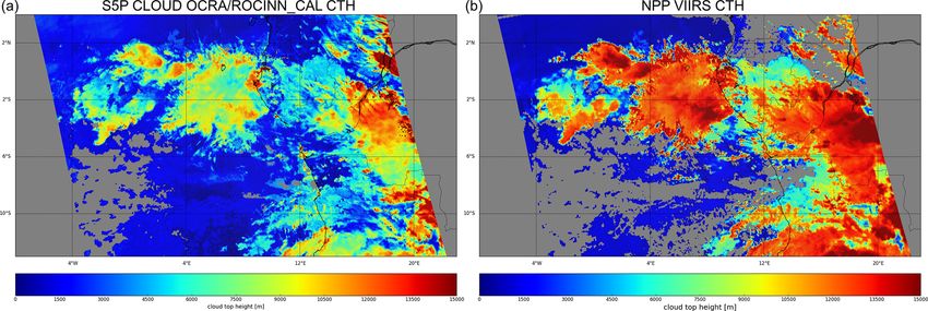
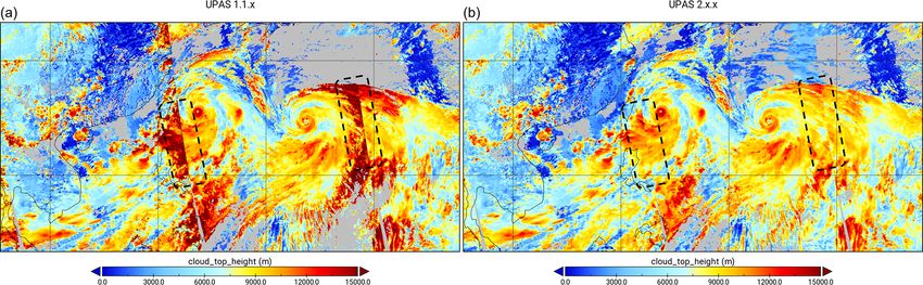
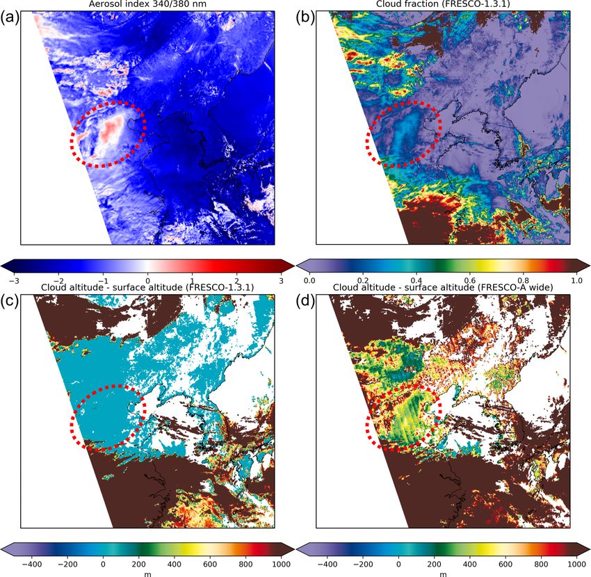
S. Compernolle et al.: Validation of S5P/TROPOMI cloud products                                                                   2453

                                                                     but a prototype one). Cloud height of the S5P products is
                                                                     compared with ground-based Cloudnet data in Sect. 4.4; here
                                                                     also a link is made to the OMI OMCLDO2 vs. Cloudnet com-
                                                                     parison (Veefkind et al., 2016). Section 5 discusses peculiar
                                                                     geographical patterns that can occur in S5P OCRA/ROCINN
                                                                     version 1 and S5P FRESCO version 1.3 and how these are
                                                                     improved in recently released (but not yet reprocessed) up-
                                                                     graded versions. Conclusions are given in Sect. 6.

                                                                     2     Description of the data sets

                                                                     2.1    Overview of cloud data products, properties, and
                                                                            related terminology

                                                                     In this work several cloud data products and cloud proper-
Figure 1. Flow chart indicating which S5P products use               ties are discussed; here we provide an overview and termi-
the cloud properties from S5P OCRA/ROCINN_CAL, S5P
                                                                     nology conventions. Table 1 contains an overview of prop-
OCRA/ROCINN_CRB, and S5P FRESCO. Note that S5P
OCRA/ROCINN_CAL and S5P OCRA/ROCINN_CRB cloud
                                                                     erties discussed in this work (either as subject to validation
properties are contained in the same S5P CLOUD product files. At     or as an important influence quantity) and the corresponding
the time of submission of this work, the S5P O3 profile is not yet   abbreviation and mathematical symbol. Table 2 contains an
operational. Note that regarding S5P CH4 , NPP-VIIRS is used as      overview of cloud data products and main cloud properties.
the main cloud mask, while S5P FRESCO is merely a backup.               The S5P cloud products we validate here (S5P
                                                                     OCRA/ROCINN, S5P FRESCO) provide a radiometric
                                                                     cloud fraction1 (RCF; frc ). Note that a RCF is related to,
                                                                     but different from, a geometrical cloud fraction (GCF; fgc )
marily for cloud correction of trace gas retrievals, a sec-
                                                                     as provided by e.g. NPP/VIIRS and MODIS. The RCF
ondary goal of S5P FRESCO is the determination of long-
                                                                     is not the geometric cloud fraction of the true cloud but
term cloud height trends by adding to the O2 A-band ob-
                                                                     can be defined as the fraction that has to be attributed to
servations that started with the measurements by GOME in
                                                                     the model cloud to yield (in combination with non-cloud
1995. The advantage over thermal infrared cloud height mea-
                                                                     contributions) a top-of-atmosphere (TOA) reflectance that
surements is its independence of temperature.
                                                                     agrees with the observed reflectance. In OCRA, the clear-sky
   The OCRA/ROCINN_CAL, S5P OCRA/ROCINN_CRB,
                                                                     (RCF = 0) reflectance is taken from composite maps created
and S5P FRESCO cloud properties are input to several other
                                                                     from satellite-measured reflectances, and the fully cloudy
S5P products: total and tropospheric ozone column, ozone
                                                                     (RCF = 1) reflectance is defined as “white” in the colour
profile, stratospheric, tropospheric, and total NO2 column,
                                                                     diagram. OCRA then determines the radiometric cloud frac-
tropospheric HCHO column, total SO2 column, aerosol layer
                                                                     tion using the differences between the reflectance (defined as
height, and CH4 column (Fig. 1). Hence, given the central
                                                                     colours in OCRA) of a measured scene and its corresponding
role of the S5P cloud products, their validation is key. In
                                                                     clear-sky values. In FRESCO, the radiometric cloud fraction
this work, a comprehensive validation is performed using
                                                                     is the cloud fraction value which, in combination with the
ground-based data from Cloudnet as well as cloud data from
                                                                     assumed cloud albedo (CA) and the input surface albedo,
other instruments: NPP-VIIRS, OMI, and MODIS.
                                                                     yields a TOA reflectance that agrees with the observed
   Section 2.1 gives an overview of the different cloud data
                                                                     reflectance. In most cases one has RCF ≤ GCF; an example
products and the cloud properties discussed in this work and
                                                                     is a scene that is fully cloud covered (fgc = 1) with an
establishes terminology. In Sect. 2.2 and 2.3 the different
                                                                     optically thin cloud (frc < 1) (Stammes et al., 2008). Note
satellite and ground-based data sets are described in more de-
                                                                     that the GCF, as opposed to the RCF, does not depend on
tail. Notes on previous assessments of the cloud algorithms
                                                                     cloud optical thickness (COT).
and on intercomparability of cloud parameters are provided
                                                                        As the cloud models of S5P OCRA/ROCINN and S5P
in Sect. 2.4 and 2.5, respectively. Section 3 discusses briefly
                                                                     FRESCO differ, their RCFs are not directly comparable.
the S5P mission requirements for the cloud data. The lat-
                                                                     Therefore, we scale the RCF to the corresponding cloud frac-
itudinal variation of zonal means of cloud fraction and of
cloud height of different satellite cloud products is compared           1 The term “effective cloud fraction” is sometimes also used in
in Sect. 4.1, while the across-track dependence is studied in        the literature (e.g. Stammes et al., 2008). Note that radiometric
Sect. 4.2. Section 4.3 compares specifically cloud-top height        cloud fraction has to be clearly distinguished from the “cloud ra-
and cloud optical thickness of S5P OCRA/ROCINN_CAL                   diance fraction” found in e.g. the S5P NO2 data product and which
with those of NPP VIIRS (not the official production release         is a different quantity.

https://doi.org/10.5194/amt-14-2451-2021                                                Atmos. Meas. Tech., 14, 2451–2476, 2021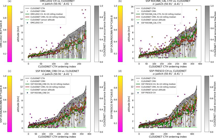
2454                                                                      S. Compernolle et al.: Validation of S5P/TROPOMI cloud products

Table 1. Properties, abbreviation, and mathematical symbol.

                                    Parameter                                                      Abbreviation         Mathematical
                                                                                                                        symbol
                                    Geometrical cloud fractiona                                    GCF                  fgc
                                    Radiometric cloud fraction                                     RCF                  frc
                                    RCF, scaled to a fixed cloud albedo a = 0.8                    sRCFb                frc,0.8
                                    Cloud-top height and pressure                                  CTH, CTP             hct , pct
                                    Cloud height and pressurec                                     CH, CP               h c , pc
                                    Cloud optical thickness                                        COT                  τc
                                    Cloud albedo                                                   CA                   Ac
                                    Surface albedo                                                 SA                   As
                                    Cloud mean heightd                                             CMH                  hcm
                                  a GCF is not derived from S5P measurements. b The relation between sRCF and RCF is
                                  frc,a = frc Ac /a . In this work a = 0.8 is always taken. c These refer to the position of the optical
                                  centroid. See e.g. Stammes et al. (2008). This depends on the optical thickness of the cloud.
                                  d Calculated as the mean of the positions of the cloudy altitude bins in a vertical cloud profile. This
                                  does not depend on cloud optical thickness.

Table 2. Overview of cloud products, algorithms, and main properties discussed in this work. The property abbreviations are explained in
Table 1.

            Product                                  Platform/sensor           Algorithm                Property                     Ref
            S5P OCRA/ROCINN_CALa                     S5P/TROPOMI               OCRA                     RCF                          Loyola et al. (2018)
                                                                               ROCINN_CAL               CTH, CTP, COTb
            S5P OCRA/ROCINN_CRBa                     S5P/TROPOMI               OCRA                     RCF                          Loyola et al. (2018)
                                                                               ROCINN_CRB               CH, CP, CA
            S5P FRESCO                               S5P/TROPOMI               FRESCO-S                 sRCFc , CP, CA               KNMI (2019)
            VIIRSd                                   SNPP/VIIRS                                         GCF, CTP, COT
            MODIS MYD08_D3e                          Aqua/MODIS                                         GCF, CTP                     Platnick et al. (2017b)
            OMCLDO2                                  Aura/OMI                  OMCLDO2                  sRCFf , CHg , CP             Veefkind et al. (2016)
            Cloudnet                                 ground-based                                       CTH, CMHh                    Illingworth et al. (2007)
          a S5P OCRA/ROCINN_CAL and S5P OCRA/ROCINN_CRB subproducts are within the same S5P CLOUD product files. b Before comparing with
          VIIRS COT, the S5P OCRA/ROCINN_CAL is first converted to an effective COT using RCF×COT. More detail is provided in Sect. 4.3. c In S5P
          FRESCO, for most pixels, CA is fixed at 0.8. However, CA > 0.8 is allowed to avoid cloud fractions larger than 1, so this is not strictly a sRCF. When
          doing actual comparisons between S5P FRESCO and other products, we therefore first convert to a strict sRCF with CA fixed at 0.8. d A prototype was
          used in the comparison and not the official (Platnick et al., 2017c) VIIRS product. e Daily gridded L3 product, based on the L2 MYD06 product. f sRCF
          with CA fixed at 0.8. g CH is not provided as such in the OMCLDO2 product. It is calculated here using the OMCLDO2 CP and a scale height of 7668 m
          (see Eq. 2). h CMH is not provided as such in the Cloudnet product. We calculate it here considering classification labels 1–7 as cloudy grid cells and
          labels 0 and 8–10 as non-cloudy, following Veefkind et al. (2016).

tion of a Lambertian reflector with fixed CA equal to 0.8                                  2.2     Satellite data sets
(sRCF; frc,0.8 ). This is explained in more detail in Sect. 2.2.1
and 2.2.2. Note that the OMI OMCLDO2 product already as-                                   2.2.1      S5P TROPOMI CLOUD OCRA/ROCINN
sumes a CA of 0.8 (Sect. 2.2.5).
   S5P OCRA/ROCINN_CRB, S5P FRESCO, and OM-                                                Here we provide technical information on the S5P CLOUD
CLDO2 all model a cloud as a Lambertian reflector. The                                     OCRA/ROCINN product. For more detail we refer the
retrieved cloud height (CH; hc ) pertains to the optical cen-                              reader to the Product Readme File (PRF), Product User
troid of the cloud rather than to the cloud top. On the                                    Manual (PUM), and Algorithm Theoretical Basis Document
other hand, S5P OCRA/ROCINN_CAL, SNPP/VIIRS, and                                           (ATBD), all available at https://sentinels.copernicus.eu/web/
Aqua/MODIS provide cloud-top heights.                                                      sentinel/technical-guides/sentinel-5p/products-algorithms
                                                                                           (last access: 20 January 2021).
                                                                                              Versioning and dissemination. The S5P CLOUD product
                                                                                           is one of the S5P UPAS products, other S5P UPAS products

Atmos. Meas. Tech., 14, 2451–2476, 2021                                                                             https://doi.org/10.5194/amt-14-2451-2021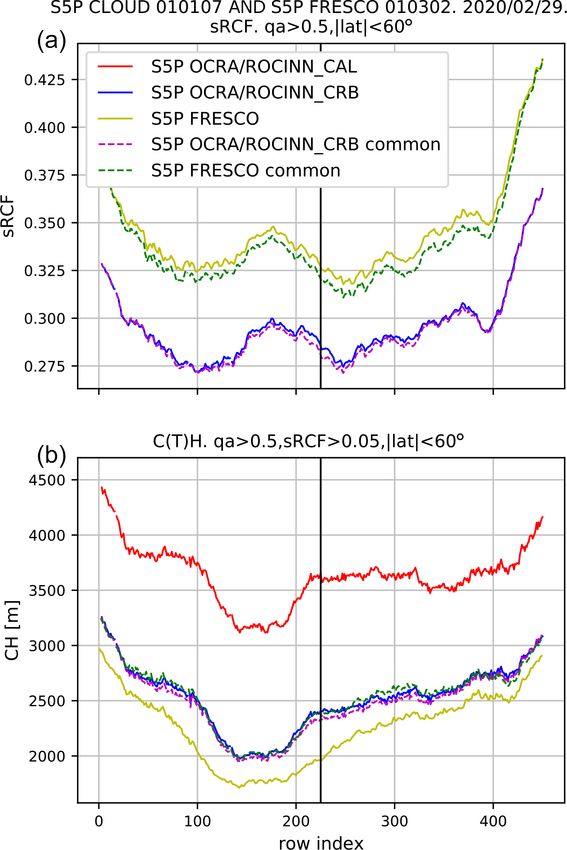
S. Compernolle et al.: Validation of S5P/TROPOMI cloud products                                                              2455

being HCHO, SO2 , O3 (total column), and O3 _TCL (tro-             with a spatial resolution of 0.2 × 0.4◦ . This relatively coarse
pospheric column). It is available from the Pre-Operations         and asymmetric spatial grid choice is due to the relatively
data hub. All UPAS products share a common processor               large and asymmetric (especially near the swath edge) OMI
version numbering. As is the case for most S5P data prod-          pixels. Thanks to the monthly temporal resolution, seasonal
ucts, the nominal operational processing produces a near-          changes can be covered. For each given day a linear inter-
real-time (indicated with “NRTI” in the file name) and an of-      polation between two adjacent monthly maps is used. In a
fline (“OFFL” in the file name) data product, with the UPAS        pre-processing step, scan angle dependencies of the colours
processor release that is active at the time. There have been      are addressed by fitting low-order polynomials to monthly
a few reprocessing campaigns to produce a consistent data          mean reflectance data as a function of colour, time, across-
set. The resulting reprocessed (“RPRO” in the file name)           track pixel position (i.e. viewing zenith angle), and latitude.
files can be combined with OFFL data for longer time series.       Instrumental degradation is currently not addressed in OCRA
By combining RPRO and OFFL data, a consistent version 1            itself since the updated L1b data will themselves include a
(Copernicus Sentinel-5P, 2018b) CLOUD data record (with            degradation correction.
processor version numbers 1.1.7–1.1.8; note that for CLOUD            ROCINN is a machine-learning algorithm for retrieving
there were no changes between 1.1.7 and 1.1.8) is available        two additional cloud parameters from the measured NIR ra-
from 30 April 2018 up to 12 July 2020, after which version 2       diances around the O2 A-band; the fitting window covers the
(Copernicus Sentinel-5P, 2020) was introduced.                     full spectral range from 758 to 771 nm. The forward prob-
   Note that for processor version 1, NRTI CLOUD uses the          lem refers to the simulation of sun-normalized radiances for
same processor as RPRO and OFFL and therefore has nearly           different cloud configurations using the VLIDORT radia-
the same output (for the same processor version). For ver-         tive transfer model (RTM) (Spurr, 2006). A significant set
sion 2 there are algorithmic differences between NRTI and          (∼ 200 000 samples) of simulated radiances, which satisfies
OFFL data.                                                         the conditions of the smart sampling (Loyola et al., 2016), is
   Below, we first describe processor version 1 (version num-      used for the training of the operational neural network (NN).
ber up to 1.1.8) and then the main changes introduced with         The replacement of the exact RTM by a NN, which is a well-
version 2 (version number starting with 2.1.3). Version 1,         tested approximation for complex operational algorithms like
for which a +2-year record is available, is the target of the      ROCINN, is in particular beneficial for gaining computa-
bulk of the analysis in this work. There has been no ver-          tional efficiency. The CH/CTH and CA/COT are the cloud
sion 2 reprocessing to date; this data record starts at 13 July    parameters which can be retrieved simultaneously using the
2020 for OFFL and at 16 July 2020 for NRTI. Some of the            Tikhonov regularization technique from two independent
main impacts of the processor version upgrade are described        pieces of information (Schuessler et al., 2014). Note that dur-
in Sect. 5. A full quality assessment of version 2 is out of the   ing the inversion a wavelength shift for the earthshine spec-
scope of the current work.                                         trum is fitted additionally (Loyola et al., 2018). Two cloud
   Version 1. The S5P CLOUD OCRA/ROCINN retrieval                  models are handled in ROCINN, (i) Clouds-as-Reflecting-
(Loyola et al., 2018) is a two-step algorithm where the            Boundaries (CRB), which considers the cloud as a Lamber-
OCRA (Optical Cloud Recognition Algorithm) (Loyola,                tian reflector, and (ii) Clouds-as-Layers (CAL), which con-
1998; Lutz et al., 2016) computes the RCF using a broad-           siders the cloud as a homogeneous cluster of scattering liquid
band ultraviolet/visible (UV/VIS) colour-space approach and        water spherical particles using Mie theory. ROCINN_CRB
ROCINN (Retrieval of Cloud Information using Neural Net-           retrieves an effective cloud height and a cloud albedo, while
works) retrieves the CTH, CH, COT, and CA from near-               ROCINN_CAL retrieves a cloud-top height and a cloud op-
infrared (NIR) measurements in and around the oxygen A-            tical thickness. The CAL cloud base height is not a retrieved
band (∼ 760 nm).                                                   quantity, but it is fixed by assuming a constant cloud geomet-
   OCRA derives the RCF from UV-VIS reflectances by sep-           rical thickness of 1 km. In version 1, other complementary in-
arating the sensor measurements into two components: a             formation about the surface properties has been initially esti-
cloud-free background and a remainder expressing the in-           mated from the MERIS monthly climatology (0.25◦ × 0.25◦
fluence of clouds. A colour-space approach is used, where          spatial resolution).
broadband UV-VIS reflectances are translated to blue and              Note that both ROCINN_CAL and ROCINN_CRB re-
green colours. The underlying assumption is that clouds ap-        retrieve the RCF with the OCRA RCF as a priori. This is
pear white in the colour space, meaning that the spectrum of       done with a strong regularization such that the values do not
a cloud is wavelength independent across the UV-VIS wave-          differ much from the OCRA RCF. After the ROCINN re-
length range. The actual radiometric cloud fraction is then        trieval, cloud(-top) pressure is obtained from the retrieved
determined as the distance between the fully cloudy “white”        cloud(-top) height using ECMWF profiles.
colour and the clear-sky colours taken from the reflectance           There is no separate treatment for snow/ice pixels, but it
background composite maps. For version 1 of the algorithm,         is known that cloud retrieval is more challenging in these
the cloud-free background is based on 3 years of OMI data          conditions.
and consists of global monthly composite maps per colour

https://doi.org/10.5194/amt-14-2451-2021                                             Atmos. Meas. Tech., 14, 2451–2476, 2021
2456                                                   S. Compernolle et al.: Validation of S5P/TROPOMI cloud products

   To summarize, there are two cloud products stored in          nominal operational processing produces an NRTI and an
the S5P CLOUD data files: S5P OCRA/ROCINN_CAL                    OFFL data product, with the NL-L2 processor release that
(providing RCF frc , CTH htc , and COT τc ) and S5P              is active at the time. Reprocessing is applied to obtain
OCRA/ROCINN_CRB (providing RCF, CH hc , and CA Ac )              a consistent data record. The main focus of our analysis
(Fig. 1 and Table 2).                                            is the RPRO+OFFL 1.3 data record which extends from
   To be able to do RCF comparisons with S5P FRESCO and          30 April 2018 to 29 November 2020. Very recently, ver-
OMCLDO2, we first convert the S5P OCRA/ROCINN_CRB                sion 1.4 was introduced. The corresponding OFFL data starts
RCF to an sRCF with a cloud albedo fixed at 0.8. In              at 29 November 2020, but to date no reprocessing is avail-
ROCINN_CRB, the cloud albedo Ac is assigned a fill value         able.
when RCF frc = 0. Therefore, the conversion is done as fol-         Below, we first describe processor version 1.3 (NL-L2 ver-
lows:                                                            sion numbers 1.3.0 to 1.3.2; note that the FRESCO version is
                                                                 identical for these numbers) and then the main changes in-
frc,0.8 = frc × Ac /0.8, if frc > 0,
                                                                 troduced with version 1.4. Version 1.3, for which a 2.5-year
frc,0.8 = 0,   if frc = 0.                                 (1)   record is available, is the target of the bulk of the analysis in
The last line of Eq. (1) is needed to prevent cases where        this work. As there has been no FRESCO reprocessing af-
frc = 0 and Ac = NaN would lead to frc,0.8 = NaN. Note           ter version 1.3, the 1.4 data record is still short, starting on
that when both RCF and CA reach unity, sRCF reaches              29 November 2020 for OFFL and on 2 December 2020 for
1.25 rather than 1. This conversion is not possible for          NRTI. Some of the main impacts of the processor version up-
ROCINN_CAL, which does not provide a CA, but as the              grade are described in Sect. 5. A full quality assessment of
RCFs of ROCINN_CAL and ROCINN_CRB are both close                 version 1.4 is beyond the scope of the current work.
to the OCRA RCF anyway, a separate evaluation is deemed             Version 1.3. FRESCO-S models a cloud as a Lambertian
unnecessary.                                                     reflector, similar to S5P OCRA/ROCINN_CRB. FRESCO-S
   Changes in version 2. Two of the more major changes in        retrieves the information on cloud pressure pc and RCF frc
version 2 are the following. In the new S5P CLOUD ver-           from the reflectance in and around the O2 A-band. FRESCO
sion 2, the OMI-based cloud-free background maps have            uses three ca. 1 nm wide wavelength windows, namely 758–
been replaced by maps based on TROPOMI data and, thanks          759 nm (continuum, no absorption), 760–761 nm (strong
to the better spatial resolution of this instrument, the maps    absorption), and 765–766 nm (moderate absorption), so
could be refined to 0.1 × 0.1◦ while keeping the monthly         both retrieved parameters pc and frc are consistently re-
temporal resolution. Furthermore, the surface properties are     trieved from the same spectral region. As opposed to S5P
no longer based on a monthly climatology. Instead, the           OCRA/ROCINN_CRB, where cloud albedo is retrieved, in
geometry-dependent surface properties are retrieved directly     FRESCO-S, the cloud albedo is assumed to be fixed at 0.8
from TROPOMI measurements within the ROCINN fitting              (see Koelemeijer et al., 2001; Stammes et al., 2008, for the
window using the GE_LER (geometry-dependent effective            justification), except when this assumption would lead to a
Lambertian equivalent reflectivity) algorithm (Loyola et al.,    cloud fraction larger than 1. In those cases the RCF is set
2020), daily dynamically updated on a 0.1◦ × 0.1◦ grid. For a    to 1, and the cloud albedo is fitted instead, but only if the
full overview of the changes in version 2, we refer the reader   cloud height is well separated from the surface. In FRESCO,
to the PRF and the ATBD.                                         the basic retrieved quantity is cloud height (in kilometres),
                                                                 which is converted to pressure using the AFGL mid-latitude
2.2.2   S5P TROPOMI FRESCO-S                                     summer (MLS) profile (Anderson et al., 1986).
                                                                    Due to the increase in the spectral resolution in the
Here we provide technical information on the S5P FRESCO-         TROPOMI instrument, the different spectral grid for each
S support product. FRESCO-S-specific information can be          viewing direction, and small wavelength shifts introduced by
found in the S5P NO2 ATBD (KNMI, 2019) and in the                inhomogeneous illumination of the spectral slit due to spa-
S5 CLOUD ATBD (KNMI, 2018). Information about ear-               tial variation of the brightness of the scene, some changes
lier FRESCO algorithms can be found in Koelemeijer et al.        were introduced in the FRESCO-S algorithm compared to
(2001) and Wang and Stammes (2014).                              previous FRESCO versions. The spectral resolution of the
   Versioning and dissemination. S5P FRESCO is one of the        reflectance database was increased to allow for interpolation
products generated by the S5P NL-L2 processor. Other S5P         of the database to the wavelengths of the observation2 . This
NL-L2 products are CO, CH4 , NO2 , AER_AI (aerosol ab-           is in marked contrast to previous FRESCO versions (for the
sorbing index), and AER_LH (aerosol layer height). Note          instruments GOME, SCIAMACHY, and GOME-2), where
that S5P FRESCO is a support product and its data files are      the observed wavelengths were interpolated to the wave-
not publicly released, but its cloud parameters can be ac-       lengths of the database. Each viewing direction has its own
cessed via the ALH or NO2 data files (Copernicus Sentinel-
5P, 2018a, c), which are available from the pre-operations          2 The database is stored with a 4-fold spectral oversampling so
data hub. As is the case for most S5P data products, the         that spline interpolation can be used for this step.

Atmos. Meas. Tech., 14, 2451–2476, 2021                                            https://doi.org/10.5194/amt-14-2451-2021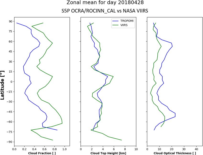
S. Compernolle et al.: Validation of S5P/TROPOMI cloud products                                                              2457

reflectance database, to adjust to the different nominal wave-     at the end of October 2011. The spectral coverage expands
length grids and the variation of the instrument spectral re-      from the visible (VIS) to infrared (IR) with 22 channels from
sponse function.                                                   0.41 to 12.01 µm at two different spatial resolutions of 375
   The FRESCO-S algorithm uses a surface albedo monthly            and 750 m. Five channels are high-resolution image bands
climatology based on GOME-2 (Tilstra et al., 2017). An im-         (I1-5 at 375 m), and 16 are moderate-resolution bands (M1-
portant advantage over the MERIS black-sky albedo clima-           16 at 750 m). The optical/microphysical property (i.e. CLD-
tology (based on 2002–2006 data, i.e. about 15 years ago)          PROP_L2_VIIRS_SNPP) cloud product refers to the pixel
(Popp et al., 2011) is that it is more recent. On the other        resolution of 750 m. This Level-2 (L2) product was devel-
hand, it is affected by the GOME-2 resolution and the solar        oped by NASA (Platnick et al., 2017c) to ensure continuity
zenith angle at overpass time. Due to the difference in over-      for the long-term records of Moderate Resolution Imaging
pass time between GOME-2 (in the morning) and S5P (in              Spectroradiometer (MODIS) and VIIRS heritages. Note that
the afternoon) and the large discrepancy in the spatial res-       the VIIRS data used in this work are not part of NASA VI-
olution of both instruments, the surface albedo climatology        IRS production release files, and potential differences cannot
is currently considered one of the larger sources of error for     be ruled out. Within the CLDPROP algorithm, the cloud-top
the FRESCO-S algorithm. To compensate, some adjustments            properties are derived from NOAA’s operational algorithms,
are made to suppress negative effective cloud fraction due to      the so-called Clouds from AVHRR Extended (CLAVR-x)
a climatological surface albedo value that is higher than re-      processing system, in which the algorithm is based primar-
ality. Also note that for scenes with a surface albedo higher      ily on IR spectral channels, with the additional informa-
than the assumed cloud albedo, the cloud parameters are less       tion of shortwave infrared (SWIR) channels. In particular,
reliable. Treatment of snow/ice surfaces is described in the       the cloud-top height is derived from the AWG (Algorithm
S5P NO2 ATBD (KNMI, 2019). The version of FRESCO                   Working Group) Cloud Height Algorithm (ACHA) (Hei-
validated here is 1.3, with the same time range as for the         dinger and Li, 2019; Heidinger et al., 2019). Moreover, the
S5P OCRA/ROCINN product. The FRESCO processing in                  cloud optical and microphysical property product inherits the
all these versions is identical, as the changes only applied to    MOD06 cloud optical/microphysical property retrieval algo-
other NL-L2 products.                                              rithm from Platnick et al. (2017b). The cloud optical thick-
   Before comparing the S5P FRESCO RCF with those of               ness COT is retrieved simultaneously with the cloud effec-
S5P OCRA/ROCINN_CRB and OMCLDO2, we first con-                     tive radius (CER) based on a two-channel retrieval intro-
vert them to an sRCF using RCF × CA / 0.8. This only               duced in Nakajima and King (1990). The COT information
makes a difference for those pixels where CA was fitted and        is primarily derived from the reflectance in a non-absorbing
not fixed at 0.8. Note that the RCF of a scene viewed in a         VIS, near-infrared (NIR), or SWIR spectral channel which
certain direction (e.g. at a large viewing zenith angle and        depends on the surface type. The CER information is pro-
forward-scattered light) can exceed unity if the reflectance       vided by the reflectance in an absorbing SWIR or mid-wave
of the cloud is larger than unity in that direction. This does     infrared (MWIR).
not violate flux conservation since that holds for the average
over all directions.                                               2.2.4   Aqua MODIS
   Version 1.4. From previous validation efforts we know
that FRESCO retrieves a height near the optical extinction         There is a Moderate Resolution Imaging Spectroradiometer
weighted mean height of the cloud, at least for scenes with a      (MODIS) instrument onboard both the Terra and Aqua satel-
significant cloud cover. For scenes with low clouds, i.e. close    lites, with Terra in descending mode passing the Equator in
to the surface, a height that is even closer to the surface will   the morning and Aqua in ascending mode passing the Equa-
be retrieved. This also holds for low aerosol layers, since the    tor in the afternoon, respectively. MODIS has 36 spectral
algorithm does not discriminate between the two types of           bands ranging in wavelength from 0.4 to 14.4 µm, and data
scatterers (Wang et al., 2012). In many cases FRESCO then          products are retrieved at three different spatial resolutions of
retrieves the surface height, which is incorrect. This defect      250 m, 500 m, and 1 km. The comparison with TROPOMI
can be remedied by using a wider window with low to mod-           can be done for the ascending MODIS/Aqua and only on
erate absorption in the O2 A-band. Instead of 765–766 nm,          a daily basis using the Level-3 (L3) MODIS gridded atmo-
a 5 nm wide window 765–770 nm increases the sensitivity to         sphere daily global joint MYD08_D3 product (Platnick et al.,
low clouds. This new look-up table is used for FRESCO ver-         2017a). It contains daily 1 × 1◦ grid average values of at-
sions 1.4 and later.                                               mospheric parameters, among others also cloud properties.
                                                                   Cloud-top temperature, height, effective emissivity, phase,
2.2.3   Suomi-NPP VIIRS                                            and cloud fraction are produced using infrared channels with
                                                                   1 km pixel resolution and stored in the L2 MODIS cloud
The Visible/Infrared Imager/Radiometer Suite (VIIRS) is            data product file MYD06_L2, which is one of the four L2
one of the five instruments onboard the Suomi National             MODIS atmosphere products used for the L3 MODIS atmo-
Polar-orbiting Partnership (NPP) satellite platform launched       sphere daily global parameters.

https://doi.org/10.5194/amt-14-2451-2021                                             Atmos. Meas. Tech., 14, 2451–2476, 2021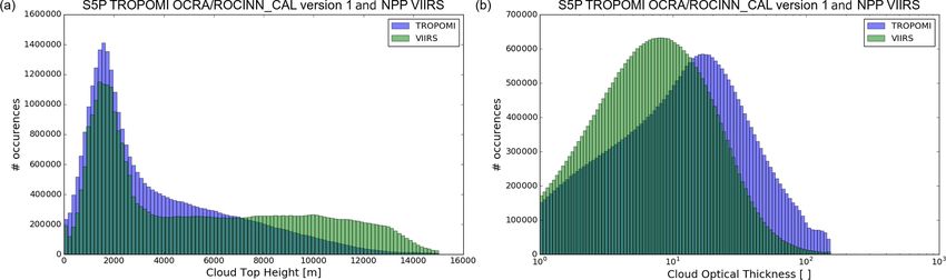
2458 S. Compernolle et al.: Validation of S5P/TROPOMI cloud products
2.2.5 Aura OMI OMCLDO2 Table 3. Selection of Cloudnet and ARM sites considered in this
work.
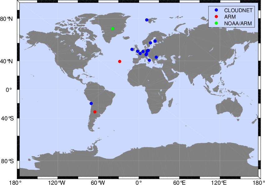
The OMI OMCLDO2 product (Veefkind et al., 2009, 2016)
is retrieved from the Level-1B VIS channel from the Dutch– Station Lat (◦ ), long (◦ ) Location Network
Finnish UV-Vis nadir-viewing spectrometer OMI (Ozone Ny-Ålesund 78.93, 11.92 Svalbard Cloudnet
Monitoring Instrument) on NASA’s EOS-Aura polar satel- Summit 72.60, −38.42 Greenland NOAA/ARM
Hyytiala 61.84, 24.29 Finland Cloudnet
lite. The nominal footprint of the OMI ground pixels is Norunda 60.85, 17.48 Sweden Cloudnet
24 × 13 km2 (across × along track) at nadir to 165 × 13 km2 Mace Head 53.33, −9.90 Ireland Cloudnet
at the edges of the 2600 km swath, and the ascending node Lindenberg 52.21, 14.13 Germany Cloudnet
local time is 13:42. The OMI instrument covers the UV and Leipzig 51.35, 12.43 Germany Cloudnet
Chilbolton 51.14, −1.44 United Kingdom Cloudnet
visible wavelength range (270–500 nm). This means that the Juelich 50.91, 6.41 Germany Cloudnet
oxygen A-band that is used by FRESCO and ROCINN is Palaiseau 48.71, 2.21 France Cloudnet
not available in the spectral range measured by OMI, and an Munich 48.15, 11.57 Germany Cloudnet
Schneefernerhaus 47.42, 10.98 Germany Cloudnet
alternative cloud retrieval algorithm is required. For OMI a Bucharest 44.35, 26.03 Romania Cloudnet
cloud retrieval algorithm was developed that uses the O2 –O2 Potenza 40.60, 15.72 Italy Cloudnet
collision-induced absorption feature at 477 nm. This is done Graciosa 39.09, −28.03 Azores ARM
by using a cloud model that is very similar to the model used Iquique −20.54, −70.18 Chile Cloudnet
Villa Yacanto −32.13, −64.73 Argentina ARM
in FRESCO (Acarreta et al., 2004; Veefkind et al., 2016).
Similar to FRESCO, it fixes the cloud albedo at 0.8, retrieves
a radiometric cloud fraction and cloud height, and is sensi-
tive not only to cloud, but also to aerosol. The sensitivity of cloud radar and lidar measurements at a temporal resolution
the O2 –O2 cloud retrieval algorithm differs from FRESCO of 30 s and a vertical resolution of 30 m to create a target
because of the different wavelength range with a generally categorization product which diagnoses the presence or ab-
much lower surface albedo, especially over vegetated land, sence in each altitude bin of aerosol, insects, drizzle, rain,
and a reduced sensitivity for (very) high clouds due to the re- liquid cloud droplets, supercooled liquid droplets, ice cloud
duced absorption at low pressures due to the density-squared particles, and melting ice cloud particles. Note that multi-
nature of the absorption feature itself (Acarreta et al., 2004). ple targets can be diagnosed within a single altitude bin. The
Otherwise, both FRESCO and O2 –O2 cloud are expected to Cloudnet L2 classification product then takes the target cat-
retrieve a height around the mid level of the cloud (Sneep egorization product and simplifies the possible combinations
et al., 2008; Stammes et al., 2008). The OMCLDO2 data into 11 main atmospheric target classifications at the same
product contains a cloud pressure, but not a cloud height. resolution (30 s and 30 m). From the classifications a cloud
Therefore, the cloud pressure is converted to a cloud height base height and cloud-top height are also derived and stored
using a scale height of hscale = 7668 m (see Eq. 2): in the product. The Cloudnet processing scheme was also ap-
plied to similar cloud-profiling measurements from the US
OMCLDO2 pc
hc = −hscale ln + hs , (2) Department of Energy Atmospheric Radiation Measurement
ps (ARM) sites. The sites included in this validation data set
with ps the surface pressure and hs the surface altitude of are provided in Table 3 and displayed in Fig. 2. Cloudnet
the OMCLDO2 pixel. The value of 7668 m was obtained by products are freely available for download from the Cloud-
fitting to the AFGL Mid latitude summer (MLS) profile (An- net database (http://cloudnet.fmi.fi/, last access: 20 January
derson et al., 1986), which is used as a reference profile in 2021).
the FRESCO algorithm. The physical horizontal extent of the cloud radar measure-
Following Veefkind et al. (2016) we include in Sect. 4.4 a ments is on the order of 20 m at 1 km altitude and 200 m at
comparison of OMCLDO2 with Cloudnet data to judge how 10 km altitude; for the lidar, the physical horizontal extent
this is different from the S5P comparisons with Cloudnet, of the measurements is about an order of magnitude smaller.
using the same comparison settings. Horizontal advection of clouds by the wind during the 30 s
averaging time implies an effective horizontal extent that is
2.3 Ground-based data sets: Cloudnet usually larger than the physical horizontal extent; for exam-
ple, a 30 m s−1 wind at 10 km yields an effective horizontal
Europe operates a network of ground-based cloud-profiling extent of 900 m for both instruments.
active remote-sensing stations as part of the Aerosol, Clouds We use the CTH provided by Cloudnet directly in our val-
and Trace Gas Infrastructure Network (ACTRIS). These idation work. Furthermore, following Veefkind et al. (2016),
stations operate vertically pointing cloud radars and li- we convert Cloudnet classification to a vertical cloud profile
dars/ceilometers and use the Cloudnet processing scheme by considering altitude bins with target classification types
(Illingworth et al., 2007) for the continuous evaluation of 1–7 as cloudy and bins with the remaining classification
cloud profile properties. The Cloudnet scheme combines the types (0 and 8–10) as cloud-free. The cloud mean height
Atmos. Meas. Tech., 14, 2451–2476, 2021 https://doi.org/10.5194/amt-14-2451-2021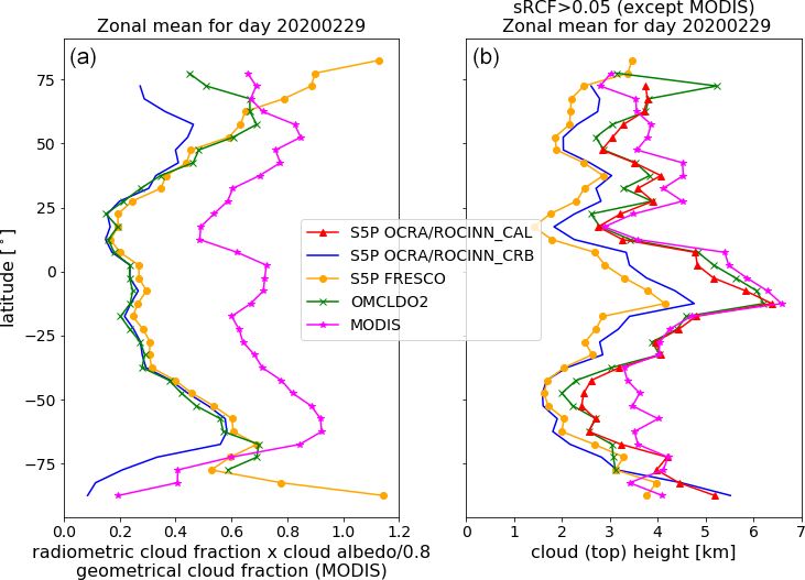
S. Compernolle et al.: Validation of S5P/TROPOMI cloud products                                                              2459

                                                                   not be obtained from single-view observations3 of the O2
                                                                   A-band and is therefore necessarily neglected in the S5P
                                                                   cloud algorithms. Loyola et al. (2018) present simulated
                                                                   OCRA/ROCINN_CAL and CRB retrievals for double-layer
                                                                   scenarios.
                                                                      As shown in the S5P-SVP (Richter and the Verification
                                                                   Team, 2015, Sect. 13.4.2.3), cloud height comparisons be-
                                                                   tween ROCINN_CAL or FRESCO with SACURA (Rozanov
                                                                   and Kokhanovsky, 2004) show larger disagreement at scenes
                                                                   with a low RCF and a higher surface albedo, indicating a
                                                                   larger uncertainty in these conditions. In agreement with this,
                                                                   simulations with FRESCO (Wang and Stammes, 2014) have
                                                                   shown that for optically thick clouds, the cloud height is
                                                                   near the optical midlevel, while for optically thin clouds and
                                                                   higher surface albedo, a FRESCO cloud height above the
Figure 2. Selection of Cloudnet and ARM sites considered in this   cloud can be found.
work.
                                                                   2.5   Note on intercomparability of cloud properties

                                                                   An issue when comparing cloud properties from different
(CMH; hcm ) is then calculated as the mean of the vertical         cloud products is that they are often not exactly compara-
positions of the cloudy altitude bins.                             ble, for example because they do not exactly represent the
                                                                   same quantity or because the sensitivities are at a different
                                                                   wavelength range. Below we give a short overview.
2.4   Note on previous assessments of OCRA/ROCINN                     Geometrical CF vs. radiometric CF. See also Sect. 2.1.
      and FRESCO algorithms                                        The GCF usually exceeds the RCF. Furthermore, the GCF
                                                                   is independent of the cloud optical thickness, while the RCF
Here follows a brief description of previous assessments of        can be related to COT. For example, whether the OCRA RCF
the S5P TROPOMI cloud product algorithms, mainly avail-            overestimates or underestimates the GCF in individual cases
able from Sect. 3 of the S5P Science Verification Report           strongly depends on the cloud optical thickness. Finally, the
(S5P-SVP; Richter and the Verification Team, 2015). It must        UV/VIS spectrometer data from TROPOMI are usually less
be noted however that in this work pre-launch versions of the      sensitive to optically very thin clouds, which might be more
algorithms were tested and that the current algorithms under-      easily detectable with imager data like VIIRS and MODIS
went significant changes since then.                               that also include bands in the infrared.
   Pre-launch versions of the S5P FRESCO and S5P OCRA                 Radiometric CF. The RCFs of OCRA, FRESCO, and OM-
RCF algorithms were compared to the MICRU algorithm us-            CLDO2 are based on different model assumptions and/or use
ing GOME-2 data (see the S5P-SVP; Richter and the Ver-             different wavelength ranges. To make these quantities more
ification Team, 2015; Sihler et al., 2020, Sect. 13.3). This       comparable, the sRCF was introduced (see Eq. 1).
study includes the across-track dependence of the difference          Cloud (top) height. The different products use differ-
between OCRA and MICRU.                                            ent wavelength ranges and/or are based on different mod-
   The operational S5P cloud retrieval and trace gas retrieval     els, for example a Lambertian reflector in the case of
algorithms are all based on one-dimensional radiative trans-       ROCINN_CRB, FRESCO, and OMCLDO2 and Mie the-
fer. The neglect of three-dimensional radiative transfer (3D-      ory in the case of ROCINN_CAL. Furthermore, Cloudnet’s
RT) effects becomes relevant due to the small ground pixel         radar-based CTH will have a higher sensitivity to optically
size of TROPOMI. The impact of cloud shadow was sim-               thin ice clouds than ROCINN_CAL’s CTH. The Cloud-
ulated in the S5P-SVP (Richter and the Verification Team,          net CMH, which is compared to ROCINN_CRB CH and
2015, Sect. 13.3.3). Other 3D-RT effects, for vertically ex-       FRESCO CH in this work, does not take into account the
tended clouds, are the dependencies of observed cloud frac-        optical thickness of the layers.
tion (Minnis, 1989) and of COT (Liang and Girolamo, 2013)             Cloud optical thickness. VIIRS COT is independent of the
on viewing zenith angle (VZA).                                     GCF, while the ROCINN_CAL COT is inversely related to
   From the results of Joiner et al. (2010), it can be as-         the RCF. ROCINN_CAL RCF × COT is therefore compared
sumed that on global average ∼ 10 % of the TROPOMI pix-            with the VIIRS COT (more details in Sect. 4.3).
els contain multi-layer clouds. Furthermore, the assumption           3 Multi-layer information can be obtained in combination with
of a homogeneous cloud field “is never valid” (Rozanov             another sensor like MODIS (Joiner et al., 2010) or from multi-
and Kokhanovsky, 2004). However, such information can-             directional O2 A-band observations (Desmons et al., 2017).

https://doi.org/10.5194/amt-14-2451-2021                                             Atmos. Meas. Tech., 14, 2451–2476, 2021
2460 S. Compernolle et al.: Validation of S5P/TROPOMI cloud products
3 Mission requirements OCRA/ROCINN_CAL (processor version 1) and VIIRS of
RCF and GCF (left panel), CTH (middle panel), and COT
The mission requirements applicable to the cloud data prod- (right panel).
uct from the atmospheric composition Sentinels were first S5P OCRA/ROCINN_CAL RCF and VIIRS GCF show
stated in ESA (2017a, b). Adapting the terminology4 to be a similar latitudinal variation, but, as expected, the geo-
compliant with the international metrology standards VIM metrical cloud fraction is higher than the S5P OCRA ra-
(International vocabulary of metrology) (JCGM, 2012) and diometric cloud fraction (Loyola et al., 2010). While the
GUM (Guide to the expression of uncertainty in measure- CTH variation is similar, variations are stronger for VI-
ment) (JCGM, 2008); these are as follows: (i) the bias in IRS. Finally, COT latitudinal variations are similar for S5P
cloud fraction, cloud height, and cloud optical thickness may OCRA/ROCINN_CAL and VIIRS, but with an offset (S5P
not exceed 20 % and (ii) the uncertainty requirement is 0.05 OCRA/ROCINN_CAL higher than VIIRS). Further details
for cloud fraction, 0.5 km for cloud height, and 10 for cloud about the comparison between S5P OCRA/ROCINN_CAL
optical thickness. We understand here that cloud fraction and VIIRS are provided in Sect. 4.3.
refers to the RCF (possibly scaled with a fixed cloud albedo), Figure 4, left panel, presents a comparison of the zonal
while cloud height can refer to both the cloud height at the means of sRCF of S5P OCRA/ROCINN_CRB (version 1),
optical centroid (as provided by S5P OCRA/ROCINN_CRB S5P FRESCO (version 1.3) and OMCLDO2, and of GCF
and S5P FRESCO) or the cloud-top height (as provided of MODIS, as a function of latitude, on day 29 February
by S5P OCRA/ROCINN_CAL). Since the beginning of its 2020. Similar results have been obtained on other days (see
nominal operation in April 2018, in-flight compliance of Fig. S1 in the Supplement). There is a good correspondence
S5P TROPOMI with these mission requirements has been between the three products between approximately −60 and
monitored routinely by means of comparisons to ground- +40◦ latitude. OMCLDO2 and S5P OCRA/ROCINN_CRB
based reference measurements in the Validation Data Analy- have a mean difference in frc,0.8 of 0.005 in this re-
sis Facility (VDAF) of the S5P Mission Performance Centre gion, while S5P FRESCO frc,0.8 is ∼ 0.03 higher than S5P
(MPC) and by confrontation with satellite data from MODIS, OCRA/ROCINN_CRB frc,0.8 . Beyond this latitude range,
VIIRS, and OMI. the sRCF diverges, with frc,0.8 becoming larger for OM-
Mission requirements relate to deviations of the satellite CLDO2 and especially for S5P FRESCO, where the sRCF
data from an (unknown) true value. However, in compar- reaches values up to 1.2. This can likely be attributed to the
isons with real-life reference data, deviations also occur due different treatment of snow-ice cases by the different cloud
to imperfect reference measurements and, moreover, because products. Also indicated in the same figure panel is the GCF
of different temporal/spatial/vertical sampling and smooth- of MODIS. The latitudinal variation shows roughly similar
ing properties (Loew et al., 2017). Frameworks and termi- variations to that of the S5P OCRA/ROCINN_CRB, S5P
nology related to comparisons are developed in Lambert FRESCO, and OMCLDO2, but, again as expected, the GCF
et al. (2013), Verhoelst et al. (2015), Verhoelst and Lambert is larger than the sRCF of the other cloud products. Note that
(2016), and Keppens et al. (2019). at the extreme latitudes, the latitudinal variation of MODIS
It should be noted that single numbers as a requirement are GCF is rather comparable to that of S5P OCRA/ROCINN
necessarily a simplification. The impact of cloud parameter than to that of S5P FRESCO.
errors depends on the cloud height and on the application Figure 4, right panel, presents a comparison of the
(e.g. cloud correction of trace gases which may or may not zonal means of cloud height of S5P ROCINN_CRB, S5P
be well mixed or cloud slicing to obtain tropospheric ozone). FRESCO, and OMCLDO2 and of the cloud-top height of
S5P ROCINN_CAL and MODIS. Pixels with frc,0.8 < 0.05
are removed (except for MODIS, where RCF is not appli-
4 Results cable), as the cloud height uncertainty becomes very high at
these low-cloud fractions. Note that for S5P ROCINN_CRB
4.1 Comparison of zonal means between cloud and S5P ROCINN_CAL, pixels with RCF < 0.05 are auto-
products matically assigned a fill value. While the latitudinal varia-
tions of cloud(-top) height of the different cloud products are
In this section zonal mean comparisons are presented
similar, there are also offsets. S5P FRESCO CH is on aver-
for the different cloud products. Figure 3 presents com-
age a few hundred metres below S5P OCRA/ROCINN_CRB
parisons at one day (28 April 2018) between S5P
CH, while S5P OCRA/ROCINN_CAL CTH and OM-
4 In the ESA documentation “bias” and “random error” are used. CLDO2 CH are ∼ 1 km above S5P OCRA/ROCINN_CRB
The term “random error” is not retained here as several components CH.
contribute to the uncertainty that are not random. Here we use the MODIS CTH is mostly higher than S5P
VIM/GUM terms bias (estimate of a systematic error) and uncer- OCRA/ROCINN_CAL CTH, being about 0.5 to 1 km
tainty (non-negative parameter that characterizes the dispersion of higher between latitudes [−60◦ , −40◦ ] and [+30◦ , −50◦ ].
the quantity values). Similar conclusions can be drawn for other days (Fig. S1).
Atmos. Meas. Tech., 14, 2451–2476, 2021 https://doi.org/10.5194/amt-14-2451-2021S. Compernolle et al.: Validation of S5P/TROPOMI cloud products 2461
Figure 3. Zonal means for S5P OCRA/ROCINN_CAL processor version 1 (blue) and NASA VIIRS (green). The comparison refers to data
from 28 April 2018 (VIIRS cloud fraction is a geometrical cloud fraction, whereas the S5P OCRA cloud fraction is a radiometric one).
The consistently higher MODIS CTH compared to S5P
OCRA/ROCINN_CAL CTH is also observed when
comparing 1 month of data (Fig. S2). These results are
consistent with Schuessler et al. (2014), showing that the
ROCINN_CAL model retrieves higher clouds than the
ROCINN_CRB model, and also consistent with the results
from Loyola et al. (2010), showing higher clouds from
infrared sounders compared to ROCINN.
4.2 Across-track dependence
The across-track dependence of sRCF of S5P CLOUD CRB
and S5P FRESCO and of C(T)H of S5P CLOUD CAL, S5P
CLOUD CRB, and S5P FRESCO, for day 29 February 2020,
is shown in Fig. 5. Note that only latitudes between 60◦ N and
60◦ S are selected to limit the impact of snow/ice. For sRCF,
pixels with qa_value > 0.5 (this is the quality indicator for
the S5P cloud products) are selected. For C(T)H, in addition,
Figure 4. Zonal means on 29 February 2020. (a) Scaled radiomet- sRCF > 0.05 is required. Note that (i) S5P FRESCO pixels
ric cloud fraction frc,0.8 of S5P OCRA/ROCINN_CRB version 1, were first remapped to the S5P CLOUD grid, and (ii) we also
S5P FRESCO version 1.3 and OMCLDO2, and geometric cloud show the common subset (FRESCO and ROCINN_CRB) of
fraction of MODIS. (b) Cloud height of the same data products, valid pixels. The sRCF is higher towards the edges of the
and in addition cloud-top height of S5P OCRA/ROCINN_CAL ver- swath due to enhanced cloud scattering along a slant path,
sion 1. Here, pixels with frc,0.8 < 0.05 are excluded (not applicable and there is a maximum in the sun glint region, west of the
to MODIS), as the cloud height becomes highly uncertain at a very middle row. The cloud height increases towards the edges of
low cloud fraction. Note that S5P OCRA/ROCINN automatically
the swath, due to the longer slant path in the O2 -A absorption,
assigns a fill value to the cloud height when RCF < 0.05.
and there is a minimum in cloud height at the location of the
sun glint region. These are effects known from other sensors
(e.g. Tuinder et al., 2010).
https://doi.org/10.5194/amt-14-2451-2021 Atmos. Meas. Tech., 14, 2451–2476, 20212462 S. Compernolle et al.: Validation of S5P/TROPOMI cloud products
4.3 Comparison between S5P OCRA/ROCINN_CAL
and NPP VIIRS
4.3.1 Data selection and processing
For the current study, six days of NASA VIIRS data have
been provided to DLR for the initial validation of S5P
OCRA/ROCINN_CAL processor version 1. To enable a
pixel-by-pixel comparison, the original 750 m NASA VIIRS
pixels have been regridded to the TROPOMI footprints as
explained in the S5P-NPP Cloud Processor ATBD (Siddans,
2016). The VIIRS cloud mask is converted to a GCF. This is
done by counting the co-located pixels within a TROPOMI
footprint and dividing the number of “confidently cloudy”
pixels by the total number of pixels (“confidently cloudy” +
“probably cloudy” + “probably clear” + “confidently clear”).
The data sets have been filtered according to several crite-
ria to ensure that the comparison is meaningful. Only data
with a OCRA/ROCINN_CAL qa_value above 0.5 were se-
lected. The S5P CLOUD snow/ice flag was used to exclude
data over such high reflective surfaces because the cloud
retrievals are particularly challenging in these conditions.
Furthermore, only pixels where both VIIRS GCF > 0.9 and
OCRA RCF > 0.9 contributed to the comparison. This filter
step mitigates artefacts of the regridding process especially
at the cloud boundaries and at scattered small-scale clouds.
Also, this high CF threshold was chosen because there one
expects the least deviations between the S5P OCRA RCF
Figure 5. (a) Mean pixel value per row index of sRCF of and the VIIRS GCF, justifying the intercomparability be-
S5P OCRA/ROCINN_CRB and S5P FRESCO. Only pixels with
tween the ROCINN and VIIRS (CTH, COT) cloud param-
qa_value > 0.5 are selected. Note that FRESCO pixels are mapped
to those of OCRA/ROCINN. The label “common” indicates that
eters. Finally, only pixels which obey the threshold criteria
the common subsets of valid pixels are taken. The black vertical of CTH < 15 km and 1 < COT < 150 were used for the val-
line indicates the middle row. Note that index 0 corresponds to idation exercise. Those thresholds have been set because the
the westernmost pixel. (b) C(T)H of S5P OCRA/ROCINN_CAL, S5P OCRA/ROCINN algorithm in CLOUD version 1 can re-
S5P OCRA/ROCINN_CRB, and S5P FRESCO. Only pixels with trieve clouds up to a maximum CTH of 15 km and with an op-
qa_value > 0.5 and sRCF > 0.05 are selected. Other conventions as tical thickness not lower than 1, while the re-gridded VIIRS
in panel (a). COT has a maximum of 150. After the aforementioned filter-
ing and harmonization process of the two data sets, the total
number of valid pixels for comparison exceeded the number
of 30 000 000.
The COT from VIIRS is not comparable directly to the
sRCF and C(T)H have a similar shape for the S5P COT because VIIRS has a geometric cloud fraction and
different products, although there are offsets. S5P not a radiometric one. For optically thin clouds, the radio-
FRESCO sRCF is slightly higher (about 0.05) than S5P metric cloud fraction is smaller than the geometric one, and
OCRA/ROCINN_CRB, in agreement with Fig. 4 (excluding this results in a higher associated COT. This is demonstrated
the extreme latitudes). When for each product only the own in Fig. S3a and b. For this reason we have introduced an
screenings are applied, S5P FRESCO CH is lower than S5P effective COT equal to COT × RCF. In this way, the lower
OCRA/ROCINN_CRB CH by roughly 200 m. However, it RCF and higher COT retrieval with respect to a GCF/COT
should be noted that the filter settings for S5P FRESCO are retrieval as in VIIRS are compensated for (Fig. S3b and c).
less restrictive than for S5P OCRA/ROCINN. When taking As demonstrated by Nakajima and King (1990), the re-
the common subset of pixels for both S5P FRESCO and flection function at 0.75 µm is in principle sensitive to the
S5P OCRA/ROCINN_CRB, a small shift in FRESCO sRCF COT, and the reflection function at 2.16 µm is sensitive to the
towards lower values is visible. Of more significance is the effective radius, but this two-channel retrieval method can
CH shift of S5P FRESCO towards higher values, becoming also be applied with a slightly different combination of wave-
close to S5P OCRA/ROCINN_CRB CH. lengths. In the case of VIIRS, the exact wavelength combina-
Atmos. Meas. Tech., 14, 2451–2476, 2021 https://doi.org/10.5194/amt-14-2451-2021You can also read