NATURAL HAZARDS 2017 Volcanic Hazard Advice: NZ & Abroad - Resilience to Nature's Challenges
←
→
Page content transcription
If your browser does not render page correctly, please read the page content below
Volcanic Hazard       High Impact Weather   Kaikōura Earthquake
                       Advice: NZ & Abroad   Research              Research

NATURAL HAZARDS 2017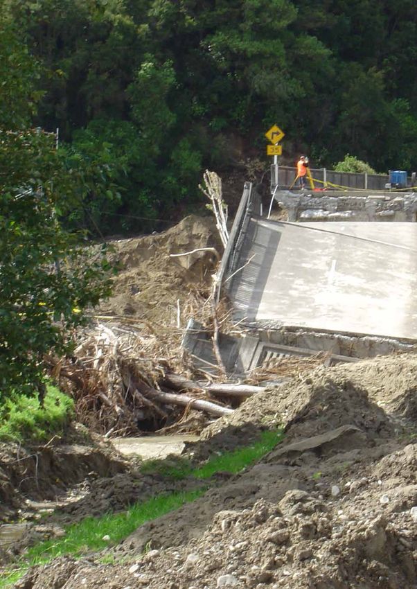
NATURAL HAZARDS | 2017

     The 50th Anniversary of the 1968 Inangahua
     Earthquake - Remembering the lessons for future
     generations. Photo: Lloyd Homer, GNS Science.

                                                                                    50th Anniversary of the Inangahua earthquake.
                                                                                    l-r: Aly Curd, Helen McCracken, Denise Blake,
                                                                                    Simon Nathan, Sophie Orchiston, Caroline Orchiston,
                                                                                    Emily Campbell, Hamish Campbell.
                                                                                    Photo: David Johnston, GNS Science.

Cover Photos:                                          Design and Layout            Citation
Front: Point Jerningham, Wellington;                   Darren D’Cruz, GNS Science   Coomer M, Rogers A, Pinal C (2018) Natural
Back: Weka Bay, Wellington.                                                         Hazards 2017. Lower Hutt, NZ:
Credit: Dave Allen, NIWA                               Websites                     GNS Science. GNS Science Miscellaneous Series
                                                                                    118, 52 pages. DOI: 10.21420/G2VS8T
                                                       www.naturalhazards.org.nz
                                                                                    ISSN 1177-2441 (Print)
                                                       www.resiliencechallenge.nz
                                                                                    ISSN 1172-2886 (Online)

                                                                                    ISBN 978-1-98-853059-8 (Print)

                                                                                    ISBN 978-1-98-853058-1 (Online)

ii
CONTENTS
      Foreword.............................................................................................. 2

      New Opportunities on the Horizon!..................................................... 3

      Increased Disaster Resilience at Franz Josef...................................... 5

      Planning for the Big One: New Zealand’s Alpine Fault........................ 8

      DIVE into a More Resilient New Zealand........................................... 14

      Tsunami Preparedness in the Chatham Islands................................ 16

      Mātauranga Māori Research.............................................................. 18

      Advances in Preparedness for the Next Volcanic Event................... 20

      Can We Evacuate Auckland Before a Volcano Erupts?..................... 22

      NZ Volcano Teams Assist Overseas.................................................. 24

      Earthquake Impacts on Wellington Buildings ................................... 26

      Liquefaction of Reclaimed Land and Impacts on Port Structures.... 30

      High Impact Weather Initiative in New Zealand................................. 33

      Ex-Tropical Cyclones Impacting New Zealand.................................. 34

      The Wellington Basin in 3D................................................................ 38

      Living at the Edge............................................................................... 41

      Natural Hazards................................................................................. 44

                                                                                                                 1
NATURAL HAZARDS | 2017

FOREWORD

Partnership is at the heart of
Science for Resilience Action.
New Zealand has very high exposure to
natural hazards with potential to seriously
disrupt the national economy and create
long-term distress for households and
communities. We have been reminded of
this confronting reality by the scale of the
losses and complexity of impacts from the
2010–11 Canterbury earthquakes, the 2016
Kaikōura earthquake, and recent extreme
weather events that overwhelmed several
coastal communities. Such events have
revealed a gap between communities’
expectations of the resilience of their land
and buildings before a disaster, and the       our policy settings and decision-making by       »» Building national capability for modelling
severe reality of the disaster experience.     all parts of society. Such action will require      economic and social consequences of
                                               transformative efforts to bring together the        natural hazards;
As a country, we cannot rely on transferring   scientific knowledge and experience to           »» Applying such models to inform
(through reinsurance) natural hazard risk as   support community discussions about the             operational readiness, risk reduction
our main disaster recovery tool, although      difficult choices we may have to make. Our          policy and infrastructure development
it will always remain essential. However,      choices are wider if we make them before            choices.
neither can we accept unconstrained            disasters happen.
increases in our exposure and vulnerability                                                     Implementation requires that we must
to disaster.                                   The Earthquake Commission (EQC) is               develop strong, collaborative relationships
                                               in a unique position to work across the          that cross the boundaries between
New Zealand needs an integrated                science, insurance, and government               science, policy, and practice within the
approach to managing disaster risk             sectors, integrating the sectors to influence    natural hazard management system.
that considers the costs and benefits of       better outcomes from the natural hazard          These partnerships will deliver science that
all potential risk management options,         management system. EQC has been                  has the ability to influence a reduction in
including avoiding or retreating from high     undertaking a major review of its research       the country’s natural hazard risk profile,
hazard areas and designing for improved        and education investment approach that           resulting in an increased resilience of
disaster resilience.                           reflects our ambition to take a stronger role    New Zealand’s built environment. The
Domestic and overseas disasters regularly      in risk reduction action to enhance national     Natural Hazards Research Platform
remind us that relatively small investments    disaster resilience.                             has been an essential feature of the
beforehand in enhanced design to reduce        The approach is driven by the ‘value             system in this regard, bringing together
damage to buildings and infrastructure, and    chain’ of investing in useful science            researchers from different disciplines and
land-use planning that avoids the worst        data that is made useable through                organisations in support of the strategic
hazard exposure, can result in significant     integration, translation and modelling, so       challenges identified by policy makers
savings in avoided losses. Risk reduction      policy-makers, planners, engineers and           and practitioners. As the Platform looks
investment also provides benefits in faster    householders can use the subsequent              to close out its successful 10 years of
community and household recovery times         information. The framework supports the          collaboration, EQC looks forward to the
and reduced social misery.                     case for:                                        successful legacy continuing into phase
                                                                                                two of the Resilience Challenge.
As a nation, the challenge is to lift our      »» Enhancing New Zealand’s knowledge of
understanding of the consequences of              natural hazards and human behaviour           Dr Richard Smith
disaster risks until they are embedded in         related to disaster risk decisions;           New Zealand Earthquake Commission

2
NEW OPPORTUNITIES ON THE HORIZON!

Welcome to our first joint
publication from the Natural
Hazards Research Platform
and Resilience to Nature’s
Challenges.
We’re pleased to be able to share with you
highlights from the past year. In this issue,
we’ll update you on programmes that are
exploring our resilience to natural hazards,
enhancing our understanding of geological
and weather processes, and improving
the functions of our lifelines and built
environment.

From the South Island, we’ll update you
on research that is helping Franz Josef
locals understand the risks they face from
natural hazards, as well as research that
is enhancing preparedness, coordination
and recovery in the event of an Alpine Fault
earthquake. Both of these programmes
are underpinned by research contributions
                                                 Natural Hazards Research Platform & Resilience to Nature’s Challenges.
from multiple teams working with local
                                                 l-r: Ali Rogers, Maureen Coomer, Anne-Marie Rowe, Shane Cronin, and Catherine Pinal.
stakeholders, and it is great to see it all
come together as a package of research
that is ‘useful, useable and used.’ We’ll also   authors from multiple countries all working            We hope you enjoy this issue of Natural
update you with the latest from volcanic         together to understand the complexity of               Hazards and wish you all the best!
hazards researchers, including advances          the event. This sharing of information - in
in eruption modelling and forecasting,           country or across borders – helps us learn             Natural Hazards Research Platform:
evacuation strategies for one of our busiest     from key events and benefits everyone                  Catherine Pinal
cities, and how New Zealand volcanic             involved.
expertise is used overseas.                                                                             Maureen Coomer
                                                 As the Natural Hazards Platform draws                  Resilience to Nature’s Challenges:
Research from the 2016 Mw7.8 Kaikōura            to a close (by 2019), we have the exciting
earthquake is still very important to New        opportunity to look forward to with the                Shane Cronin
Zealand but also overseas, especially in         Platform becoming embedded in the                      Anne-Marie Rowe
high seismic zones. This issue provides          Resilience Challenge. The combination of               Ali Rogers
an update on the earthquake’s impacts on         these two research entities will provide a
Wellington buildings, liquefaction impacts       strong base of expertise and resources.
on reclaimed land, and how ground                Currently, researchers are engaging with
shaking is influenced by subsoil properties.     stakeholders to shape this next phase.
Many of the Kaikōura research outputs            We’d like to acknowledge all those who are
have been published in a special issue of        contributing their time and effort towards
the Bulletin of the Seismological Society        identifying key research that will bring
of America. These papers, most led by            about a greater resilient future.
New Zealand scientists, feature numerous

                                                                                                                                                  3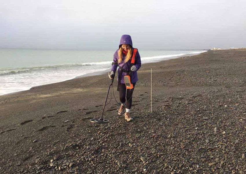
NATURAL HAZARDS | 2017

An example of Alex Dunant’s model prediction of potential peak flows from landslide dambreak floods north of Kaikōura.

4
INCREASED DISASTER RESILIENCE AT FRANZ JOSEF

INCREASED DISASTER
RESILIENCE AT FRANZ
JOSEF
By
TIM DAVIES, MARK BEBBINGTON, KAT HORE,
ALEX DUNANT, ALI DAVIES, AND TOM WILSON

The Franz Josef Glacier township lies in one of the most
beautiful and active landscapes in the world. It is a world-
leading and rapidly-expanding tourist destination of national
importance, with the tourism industry having overtaken
traditional local occupations of farming and forestry. The
extreme landscape activity threatens the township and
community with the potential for a range of hazard events
including earthquake, flood, landslide and rockfall, among
others. The Franz Josef community is concerned about its
long-term ability to live through, and prosper after, the next
significant natural hazard event that strikes it.

A research team funded by the Resilience         As a starting-point for understanding
to Nature’s Challenges Hazards Toolbox           what is required to improve resilience, the
has been collating available natural hazard      team is focussing on ways in which the
information and working with the Franz           community can plan in advance to reduce
Josef community to better understand             and adapt to the impacts of severe hazard
these hazards and the effects they may           events. The impacts include loss of power,
have. They have generated scenarios              loss of communications, and loss of road
representing the impacts that these              access, all of which, especially if of long
hazards – singly, in combination, or as a        duration, would severely reduce the ability
cascade – will have on the town’s assets         of the township to function.
and on the regional lifelines. This can shed
light on the functions of the community that
allow it to survive commercially and socially.

                                                                                            5
NATURAL HAZARDS | 2017

Hazards the Franz Joseph community are vulnerable to.

Community output from working session.

6
INCREASED DISASTER RESILIENCE AT FRANZ JOSEF

The West Coast Regional Council               The full combinations of natural hazard         The Hazards Toolbox team works closely
asked environmental and engineering           events that can impact Franz Josef              with the Franz Josef community, Regional
consultants Tonkin + Taylor to investigate    are currently unknown, especially their         and District Councils, Civil Defence
the township’s options for increasing its     ability to form ’hazard cascades’. Hazard       Emergency Management Groups and
resilience to natural hazards. In late 2017   cascades occur when, for example, an            lifelines organisations.
the company presented three options to        earthquake causes a major landslide that
the Franz Josef community that offered        blocks a river to form a landslide dam. This    Contact:
varying levels of resilience ranging from     dam can fail when it overtops, sending a        Tim Davies
lower-cost options where the township         ’dambreak flood’ down the river to threaten     University of Canterbury
stays where it is, to a higher cost option    communities already reeling from the            Tim.Davies@canterbury.ac.nz
in which the entire township is moved         earthquake. PhD student Alex Dunant at
from the high-risk area. The community        the University of Canterbury is developing
is currently discussing these adaptation      a simulation model which will examine
options. PhD researcher Kat Hore from         all possible combinations and cascades
The University of Auckland is living in the   of hazards affecting all societal assets.
Franz Josef township for extended periods     This model is designed so that it can be
in order to understand how communities        applied not only locally, as at Franz Josef,
grapple with such significant decision-       but across much larger areas. This will
making processes.                             enable the work to be linked to that of PhD
                                              student Ali Davies, who is investigating the
                                              resilience of regional infrastructure and its
                                              impacts on isolated communities like Franz
                                              Josef.

                                                                                                                                         7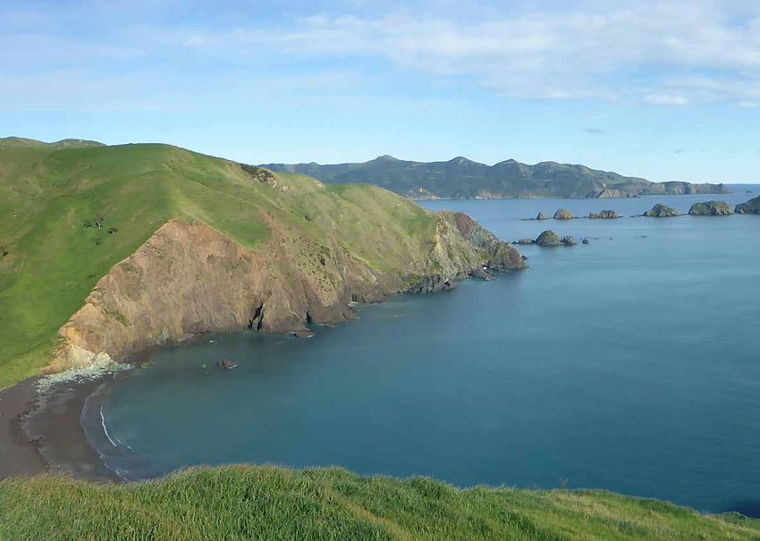
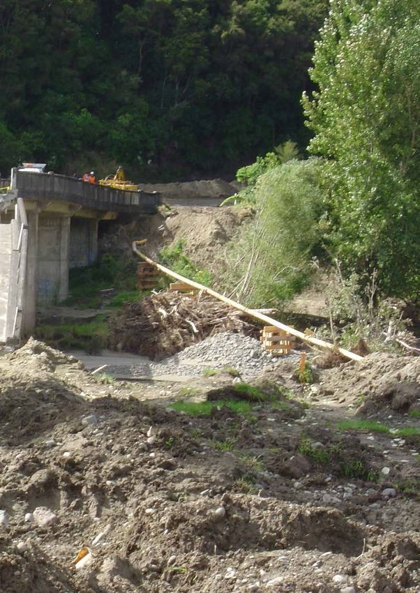
NATURAL HAZARDS | 2017

PLANNING FOR
THE BIG ONE:
NEW ZEALAND’S
ALPINE FAULT
By
CAROLINE ORCHISTON, TOM WILSON,
GARRY MCDONALD, AND LIAM WOTHERSPOON

8
NEW ZEALAND’S ALPINE FAULT

The Alpine Fault, Lake Poerua and Taramakau River.
Photo: Lloyd Homer, GNS Science.

The Alpine Fault is a major
plate boundary fault running
through the South Island,
that has a long history of
generating large earthquakes.
The fault produces magnitude
8 earthquakes every c. 300
years, and the last one was
in 1717 AD (301 years ago). A
magnitude 8 earthquake on
the Alpine Fault would widely
impact the South Island and
its effects would be felt across
the rest of the country, so are
we prepared for the next one?
Resilience to Nature’s Challenges research
teams are working with Civil Defence
Emergency Management (CDEM) and
lifelines agencies in the South Island to
improve our understanding of the likely
impacts of an Alpine Fault earthquake
and to enhance the way we respond and
recover.

                                                 9
NATURAL HAZARDS | 2017 The location of the Alpine Fault and plate movement. 10
NEW ZEALAND’S ALPINE FAULT

The research teams are working in              strong relationships between West Coast
partnership with Project AF8, a South          Lifelines infrastructure organisations
Island-wide Alpine Fault earthquake            and researcher teams. In partnership
response planning initiative. The project,     with RiskScape, models of casualties,
led by the six South Island CDEM groups        injuries, building damage, habitability and
and co-funded by the Ministry of Civil         displaced populations were developed.
Defence and Emergency Management               The models have been highly commended
(MCDEM), aims to produce a cutting-edge        by CDEM Group Managers, having added
scenario-based earthquake response             an important element of realism to the
plan informed by the latest research in        scenario, and allowed regional CDEM
earthquake science. The so-called South        groups to tailor their response plans to the
Island Alpine Fault earthquake response        needs of their local area.
(SAFER) framework will improve the ability
                                               An initial assessment of the economic
of South Island CDEM groups and their
                                               disruption impacts associated with an
partner agencies to respond, drawing on
                                               Alpine Fault event was undertaken using
hazard and resilience science from the
                                               the ‘Measuring the Economics of Resilient
wider natural hazard research community.
                                               Infrastructure’ (MERIT) tool – a novel
Multiple Resilience Challenge research         analytical model that simultaneously
programmes have been involved in the           quantifies the economic consequences
project; the Rural Co-Creation Laboratory,     of infrastructure failure across space and
as well as the Hazard, Infrastructure and      through time for multiple stakeholders.
Economics Toolboxes. In collaboration          The MERIT modelling has revealed
with QuakeCoRE, GNS Science and                significant impacts to the New Zealand
EQC, these teams have developed the            economy generated by an Alpine Fault
resilience science outputs required for the    earthquake. Although MERIT covers all
project to be a success. They have used        economic sectors, the project focused
a scenario-based co-creation method, in        on the regionally significant dairy
which emergency managers, earthquake           manufacturing, coal mining and tourism
hazard and disaster resilience scientists      sectors. This included modelling three
and partner organisations work together        dairy sector sub-scenarios constituting
to build a clearer picture of what a future    high, medium and low physical impacts,
earthquake event might look like across        which when considered together give a
the South Island. The following outlines       broad indication of financial impact. As an
some of our work over the past two years.      example, one year after an Alpine Fault
                                               earthquake the loss in Gross Domestic
The main output has been the
                                               Product (GDP) is estimated to be between
development and socialisation of the
                                               NZ2015$156 and $586 million, depending on
SAFER framework, which has as its
                                               sub-scenario. Most of the impact would
foundation a robust, scientifically credible
                                               be felt in the West Coast region, making up
Alpine Fault scenario. New science on the
                                               87% of the total GDP loss. Dairy product
impacts and consequences of a future
                                               manufacturing is estimated to be the most
Alpine Fault event, including restoration
                                               affected industry, making up between 12%
timeframes and impacts on critical lifelines
                                               and 59% of the GDP loss depending on
infrastructure were developed through
                                               sub-scenario.

                                                                                          11
NATURAL HAZARDS | 2017
CDEM Stakeholder workshop for Project AF8.
Building on the relationships developed The AF8+ scenario is also being used to
through the AF8 co-creation process, assess new methodologies to quantify
the 7-day AF8 hazard scenario has the resilience of infrastructure networks
been extended out to 10 years post- across the South Island. The National
quake, known as the ‘AF8+ scenario’. Interdependent Infrastructure model, able
Infrastructure outages and their to simulate the propagation of network
subsequent recovery were developed disruption both within each network itself
over this extended timeframe, and are (direct) and across into other networks
being used to guide recovery planning (indirect), was used with the AF8+ scenario
and for the development of long-term to quantify the expected direct and
resilience collaborations between lifeline indirect disruption throughout the recovery
organisations and communities on the process. A new electricity resilience
West Coast. framework is being assessed using this
scenario, including application of new
methods to manage the power system and
to rapidly restore functionality if the West
Coast is cut off. The outcomes of these
projects will help assess pre- and post-
event investment decisions.
12NEW ZEALAND’S ALPINE FAULT
As can be seen throughout the work of The success of Project AF8 has been Contact:
these research programmes, the key to driven by the strong collaboration across
Caroline Orchiston
the success of this initiative has been the natural hazard community, and University of Otago
collaboration with stakeholders. To date engagement with key agencies and
Caroline.Orchiston@otago.ac.nz
64 workshops or science presentations organisations with a role to play in the
have been run with a combined 4,350 response. Next steps for Project AF8
attendees, which have included include greater outreach and engagement
stakeholders from local government, with at-risk communities, improving the
MCDEM, District Health Boards, police, social media presence of the project,
private corporate stakeholders and CDEM evaluating the effectiveness of the science
Groups from Southland to Nelson-Tasman and engagement approach, developing
and Wellington. These workshops have new/improved impact assessment models,
brought all the parties together for the first and working to ensure the excellent profile
time to discuss this major hazard event, and achievements of AF8 continue for
and have provided each group with the years to come. Because people are talking
opportunity to highlight their capabilities about the Alpine Fault, and let’s face it, it is
and challenges. Open conversations all about the people.
help us all learn how we can collectively
respond, by breaking down traditional
silos and working across jurisdictions.
The activities have catalysed a number of
disaster resilience projects and initiatives
within many of these organisations
to enhance disaster planning and
preparedness, from local community
groups through to national agencies.
13NATURAL HAZARDS | 2017
The Resilience Challenge Trajectories research team dicussing their toolbox’s projects.
DIVE INTO A MORE RESILIENT
NEW ZEALAND
By JOANNE STEVENSON, ELORA KAY, AND JOHN VARGO
The key to New Zealand’s Across the country there are datasets for Earthquake Resilience and Resilience
from extensive, ongoing research on to Nature’s Challenges ran a series of
exciting resilience innovations
disaster risk reduction and resilience, workshops. They wanted to find out the
might not be as far away as we but no integrated way to share and critical data needs for researchers and
think. In fact, it might already search that information. This seemed research stakeholders in the disaster risk
like a missed opportunity, so in 2016, a reduction (DRR) and resilience space so
be sitting in the computers of
collaborative team of researchers funded that they could formulate a plan.
researchers nationwide. by QuakeCoRE - New Zealand Centre
14DIVE INTO A MORE RESILIENT NEW ZEALAND
DIVE Platform datasets webpage.
Several key needs were identified. place where people can let others know The NZ Resilience DIVE Platform is created
Researchers and stakeholders needed a about the data, publications, and ongoing and maintained by Resilient Organisations
system where they could find out about research relevant to DRR and resilience. and, ultimately, by New Zealand’s research
ongoing research before publication, DIVE also has the capacity to host unique community. As a sharing platform, this
and through which data could be datasets, and the team is currently working collaborative site provides a tool for
easily searched for and shared across with researchers who have datasets transformational research, allowing for
organizations. They also needed standards that they would like a wider audience to innovative new discoveries through the
and guidance for transdisciplinary data access or reuse. The platform is also a recycling of data. It is also hoped that
management that facilitate data integration, place where those interested in DRR and DIVE can act as a catalogue or repository
analysis, and visualisation, and in addition, resilience in New Zealand can connect and for information produced in disaster
better access to public, proprietary, and collaborate, forming virtual organisations response and recovery contexts and can
sensitive data sources, and the ability to for sharing information. Finally, DIVE aid decision making in the wake of natural
track data reuse. provides access to data literacy tools disasters. DIVE can be accessed from
for those wanting to know more about resiliencedata.org.nz.
In light of these findings, the team
metadata and spatial data, and why these
developed the Data Integration and Contact:
things are important for a more resilient
Visualisation En Masse (DIVE) Platform.
The NZ Resilience DIVE Platform website
New Zealand. Joanne Stevenson
Resilient Organisations
gives users the ability to catalogue, DIVE has been created using a software
discover, share, and use datasets and platform (CKAN) that can be transferred to Joanne.Stevenson@resorgs.org.nz
other information relevant to DRR and another host (such as data.govt.nz) should
resilience in New Zealand. DIVE is, first the platform be decommissioned. This
and foremost, a metadata catalogue, a ensures the longevity of users’ uploaded
information.
15NATURAL HAZARDS | 2017 TSUNAMI PREPAREDNESS IN THE CHATHAM ISLANDS By KRISTIE-LEE THOMAS Kristie-Lee Thomas speaking to students at Te One School. 16
August 15th, 2018 marked                          A group of GNS Science researchers                  RiskScape, EQC, and the Ngāi Tahu
                                                  visited the Chathams to commemorate                 Research Centre, Kristie-Lee studied
150 years since the Chatham
                                                  the event with the community, alongside             archives and literature on the event, and
Islands were hit by three large                   Chatham Islands Council Emergency                   also spoke with kaumatua (Māori elders)
tsunami waves, generated by a                     Management Office. Included in the group            on the Chatham Islands who shared their
                                                  was researcher and Chatham Islands                  knowledge about the tsunami.
magnitude 8.5-9.0 earthquake
                                                  local Kristie-Lee Thomas, who recently
off Arica (then in Peru, now                                                                          As well as uncovering previously
                                                  completed her master’s thesis with the
                                                                                                      undocumented insights into the 1868
in northern Chile). Waves                         University of Canterbury investigating
                                                                                                      tsunami, Kristie-Lee’s research helped
                                                  tsunami risk to the Chatham Islands.
of up to 6 metres inundated                                                                           to guide the locations of new tsunami
the islands, flooding over                        While there, Kristie-Lee shared findings            evacuation zones on the Chatham Islands.
                                                  from her thesis, which investigated                 The zones were determined using scientific
6km inland and destroying                         both documented and Māori oral                      modelling alongside Kristie-Lee’s findings
buildings, bridges and homes.                     history accounts of past tsunami on the             around past tsunami inundations, which
                                                  Chathams, including the 1868 event. As              were drawn from oral and documented
                                                  part of this research, which was supported          accounts.
                                                  by Resilience to Nature’s Challenges,
                                                                                                      Contact:

                                                                                                      Kristie-Lee Thomas
                                                                                                      GNS Science

                                                                                                      k.thomas@gns.cri.nz

                                                                           Gathering at Waitangi West, acknowledging the fatality that occurred at this
                                                                         beach and also those who lost their lives nearby at Tupuangi where the village
                                                                             was destroyed and three families are thought to have been washed away.

Remnant of a European house at Tupuangi destroyed by the 1868 tsunami.

                                                                                                                                                     17
NATURAL HAZARDS | 2017 MĀTAURANGA MĀORI RESEARCH PROVIDING NEW INSIGHTS INTO NATURAL HAZARDS AROUND NEW ZEALAND / AOTEAROA By JONATHAN PROCTER The Mātauranga Māori cross-cutting laboratory within the Resilience Challenge is supporting experienced and new and emerging Māori researchers to explore mātauranga Māori (Māori knowledge), from oral traditions, observations and historical accounts of natural hazards. This source of information and data contributes to our understanding of natural hazard events and also provides lessons on how to respond and recover, as well as explore more meaningful ways to communicate resilient solutions to Māori and New Zealand/Aotearoa. The research is producing new hazard and The first paper by Hollei Gabrielsen are that Māori observed and noted environmental management tools and iwi explores the knowledge of volcanic events various volcanic events and recorded their development strategies that are based on recorded by Ngāti Rangi and their past experience in waitata or songs that not long-lived traditional planning techniques reactions and responses to volcanic only describe the physical phenomena that have been successful in the face phenomena. Ngāti Rangi and other tribes occurring, but also provided practical of New Zealand/Aotearoa’s natural affiliated to the volcanoes of the central advice on how to respond in the future. challenges for over 500 years of human North Island are intimately connected The following is from Gabrielsen’s article: occupation. Two recent publications from to, and familiar with, the moods, signs, O rongo Ruapehu. Turaki auahi. the programme outline the contributions and language of the volcanoes and Puahiri Whakarunga. Ki whai tua ee that investigating traditional practices have valuable knowledge to contribute If you ever hear Ruapehu Erupting can make to improving our knowledge to warning system development and with ash. You can be comforted of hazardous events and developing decision-making during and after volcanic knowing. The prevailing wind takes it resilience (Gabrielsen et al 2017; events. Key learnings from this research elsewhere King et al 2018). 18
The northern coast of D’Urville Island where ongoing work alongside
                                                                                Ngāti Koata and Ngāti Kuia will take place over the months ahead.
                                                                                                                         Photo: Emily Lane, NIWA.

Tukutahi te puehu turaki whakatua               past tsunami - possibly multiple events -        References
Ka whakahoki mai hei tāpora mō                  on and surrounding Rangitoto (D’Urville
te nohoanga ia koutou mā eei.                                                                    Gabrielsen, H. et al (2017) Reflections from
                                                Island). The multiple layers of information      an Indigenous Community on Volcanic Event
Behold! An eruption of ash. Do not              gathered show a rich system of knowledge         Management, Communications and Resilience.
fear, this ash will cloak and replenish         recording past catastrophic natural              In: Advances in Volcanology. Springer, Berlin,
the land and help us live as one                hazards and the corresponding response           Heidelberg.

A uniquely New Zealand lesson to be             actions. This work not only contributes to       King, D.N. et al (2018) Māori oral histories
learnt from this research is that Ngāti         the production of ‘new’ narratives about         and the impact of tsunamis in Aotearoa-New
                                                tsunami disturbance, recurrence and risk         Zealand. Natural Hazards and Earth System
Rangi regard Ruapehu as their ancestor,
                                                                                                 Sciences 18(3): 907-919.
Koro or Matua te Mana, and personalise          around the New Zealand coast, but also
all volcanic activity as part of his moods      shows that skills in trans-cultural research     Contact:
and behaviour, which people living there        enquiry will be required to advance our
should respect and to which they should         geosciences knowledge.                           Jonathan Procter
                                                                                                  Massey University
pay attention.                                  Mātauranga Māori is also being                   J.N.Procter@massey.ac.nz
The 2018 article of Darren Ngaru King           investigated in other areas of New Zealand
provides an important account of tsunami        (e.g. University of Canterbury and the
activity in New Zealand and how people          Rekohu/Chatham Islands; Te Whare
chose to respond to this, as well as            Wananga o te Awanuiarangia and the Te
insights into how to transfer knowledge         Moana-a-Toi/Bay of Plenty), unearthing
associated with these natural hazards.          many new accounts of natural hazards
Working alongside key informants from           that will contribute to our understanding
Ngāti Koata and Ngāti Kuia to explore           of the frequency and magnitude of such
traditional whakapapa, sites of significance,   events in the past of New Zealand /
and histories and achievements of past          Aotearoa.
ancestors, they confirmed experience with

                                                                                                                                                19
NATURAL HAZARDS | 2017
ADVANCES IN PREPAREDNESS FOR
THE NEXT VOLCANIC EVENT
By JONATHAN PROCTER, MARK BEBBINGTON AND STUART MEAD
Over past decades, our understanding of individual volcanic eruptions, and our ability to simulate
them, has progressed considerably. However, there is still more to do to address one of the key
risk dimensions of volcanic eruptions: that is, to better understand their dynamic evolution during
the course of an eruption sequence, and how it may lead to multiple, and strongly interdependent,
hazards and impacts.
In the NHRP programme ’Quantifying improved approach that broadly defines the easily reduced to an instant in time. Any
exposure to specific and multiple volcanic form of the relationship between simulation usable definition of an eruption has to
hazards,’ researchers from Massey inputs and hazard. These relationships are allow for activity over timescales ranging
Canterbury, Auckland, and Victoria combined and fitted to simulation results from minutes to decades, allowing for
universities and GNS Science are involved to estimate hazard intensity (e.g., such as multiple eruptive phases. These phases
in two groundbreaking initiatives that are flow height for pyroclastic currents) at any can be defined by having different styles
making significant advances in probabilistic input configuration and the uncertainty of activity and/or quiescent periods
modelling and computational simulation associated with this estimate, which is between them. Statistical advances have
that will enable us to increase our crucial. This innovative approach reduces allowed us to calculate likelihoods for the
preparedness for the next volcanic event. the number of simulations needed to next step of the eruption, conditional on,
provide a hazard estimate and makes for example, the duration of the current
Multi-hazard assessments raise
the problem of determining multi-hazard phase, and the duration of the quiescence
operational and methodological issues
intensity computationally feasible. preceding it. This has been applied to the
that are often more complex than single
Te Maari eruption and Figure 2 shows the
hazard assessments. Multi-hazard We have developed a working model by
comparison between the model and expert
assessments require a shift from hazard- simulating pyroclastic density currents
opinion of the eruption’s progression.
centred to location-centred assessments originating from the summit of Mt Taranaki,
and significantly increase the size and as shown in Figure 1. Work is ongoing to These research directions, new simulation
computational burden of the simulations. adapt this methodology to all hazards. tools and statistical models highlight the
In this project, Stuart Mead is using a progress that is being made towards our
Also in this project, Mark Bebbington is
relatively new statistical technique to ability to forecast future volcanic events
exploring the possibilities of forecasting
interpolate between simulation results and and their impacts.
the multiple phases within an eruption
provide an estimate of the volcanic hazard
and applying this to past eruptions at Contact:
intensity for all volcanic hazards, and all
Mt Tongariro (Te Maari, 2012) and Mt
possible initial conditions, such as size
Pinatubo (1991). Forecasting eruption Jonathan Procter
and location. Previous simulations have Massey University
onsets, in both the short- and long-term,
simplified the relationship between volcanic J.N.Procter@massey.ac.nz
has received much attention. However,
processes and hazards, and are unsuitable
unlike an earthquake, an eruption is not
for our project. We have developed an
20VOLCANIC ERUPTION MODELING & FORECASTING
Fig 1. The potential hazard associated with a pyroclastic flow from Mt Taranaki using new computer simulation tools. The coloured areas show all
possible inundation areas associated with pyroclastic flows. Red shading highlights the areas more likely to be inundated by pyroclastic flows.
Fig 2. A comparison between the statistical
intra-eruption model and expert opinion of the
probability that the 2012 Te Maari eruption has
ended. The use of expert opinion contributes
to the development of probabilistic models that
tell us more about the potential of volcanic
activity occurring.
21NATURAL HAZARDS | 2017
CAN WE EVACUATE AUCKLAND
BEFORE A VOLCANO ERUPTS?
By SEOSAMH COSTELLO
Resilience Challenge researchers have been investigating
whether it would be possible to evacuate parts of New Zealand’s
largest city if an eruption occurred in its volcanic field.
There are at least 50 discrete volcanoes Researchers in the Resilience to Nature’s
within a 20km radius of Auckland City, and Challenges Infrastructure team are working
the region has had repeated and varied to address some of this uncertainty
volcanic eruptions in the past, with the last through two research projects. The first
one (Rangitoto) occurring 600 years ago. is investigating how drivers behave in an
While Auckland’s volcanoes are relatively emergency situation in Auckland. Currently
small, an eruption would cause serious we only know how drivers behave during
problems due to high population densities. regular daily activities, but how they
This is coupled with Auckland’s geographic behave under pressure could be quite
location being poorly suited for evacuation, different.
with the only terrestrial routes out of the
The second project is building a simulation
area being through two isthmuses (narrow
model of Auckland’s transport network.
sections of land that connect larger
The model will estimate the time needed
landmasses), creating a large potential for
to evacuate affected areas, the number
traffic congestion.
of people unable to evacuate in time, and
There has never been a mass evacuation the location of traffic bottlenecks in case of
of Auckland City, and there is limited evacuation.
data to suggest what might happen
Findings from both of these studies will
should residents need to evacuate.
enable transport planners and emergency
Plus, evacuation behaviour would vary
management officials to better prepare for
tremendously depending on factors like
an eruption and maximise the number of
the location, style, sequence and advance
people safely evacuated.
warning of the eruption.
Contact
Seosamh Costello
The University of Auckland
S.Costello@auckland.ac.nz
Traffic congestion on Auckland’s SH16.
Photo: Daniel Blake,University of Canterbury.
22NATURAL HAZARDS | 2017
NZ VOLCANO TEAMS
ASSIST OVERSEAS
By NATALIA DELIGNE AND GRAHAM LEONARD
During 2018, New Zealand researchers
supported overseas colleagues in two
ongoing volcanic eruptions in the Pacific -
first in Ambae, Vanuatu; then in Kilauea,
Hawai’i.
Graham Leonard (GNS Science) and Sandrine Cevuard (VMGD) arrive in West Ambae, Vanuatu
to survey ash and acid rain impacts from the eruption in March 2018. The team also set up
drinking water sampling sites for ongoing monitoring. Photo: GNS Science.
24NZ VOLCANOLOGISTS OVERSEAS
New Zealand is known for its world-
leading research programme concerning
volcanic impacts, particularly in the areas
of infrastructure, agriculture, and health;
expertise that has made us a valued
partner during eruption responses.
Volcanologists from GNS Science, the
University of Canterbury, and Massey
University provided in-country support to
the Geohazards Division of the Vanuatu
Meteorology and Geohazard Department
(VMGD), involvement made possible
with support from the New Zealand Aid
Programme of the Ministry of Foreign
Affairs and Trade. New Zealand has also
provided remote support by undertaking
laboratory work to assess ash and drinking
water samples. The team has supported
the development of key messages around
dealing with volcanic gas, acid rain, and
heavy ashfall, in addition to roof cleaning
and the potential for roof collapse.
The current eruption at Kilauea,
Hawai’i with concurrent activity at the
Halema`uma`u summit crater and on the
East Rift Zone, has received considerable
media attention. Behind the scenes, New
Zealand researchers have maintained
and updated the USGS-hosted Volcanic
Ash Impacts & Mitigation webpage, and
answered questions from the public about
how to best deal with volcanic ash.
Both eruptions have been difficult and
testing for local communities. New
Zealand’s investment in researching
volcanic impacts has directly assisted
with the response to both of these events.
These eruptions also provide valuable
lessons that will help New Zealand when
we in turn are faced with a local disruptive
and damaging volcanic eruption.
Contact:
Graham Leonard
GNS Science
G.Leonard@gns.cri.nz
Carol Stewart (JCDR) and Sandrine Cevuard (VMGD) collect ash, soil and
vegetation samples from West Ambae, Vanuatu to assess the impacts.
Photo: GNS Science.
25NATURAL HAZARDS | 2017 EARTHQUAKE IMPACTS ON WELLINGTON BUILDINGS By KEN ELWOOD Precast concrete units are commonly used as components of floors in New Zealand multi-storey buildings. Recent earthquake observations, including after the 2016 Mw7.8 Kaikōura earthquake, demonstrated significant issues that are being addressed by critical research. 26
Damage to Statistics House following the 2016 Kaikōura earthquake.
                                                                                                            Photo: Statistics New Zealand.

The Canterbury and Kaikōura earthquakes
have shed new light on precast concrete    Statistics House during the Kaikōura
floors. The early use of these units in    earthquake. Of particular concern is            form of floor construction during this time
ductile concrete buildings has revealed    the fact that there was a general lack of       period. Research at the University of
support connections that were in some      specific design requirements provided for       Canterbury in the early 2000’s identified
cases inadequate to accommodate            the support of precast concrete flooring        the vulnerabilities of these floors and led
earthquake-imposed deformations. This      systems during the 1980s, a time when           to the development of support connection
inadequate detailing potentially results   construction in New Zealand was booming         detailing (introduced in 2004) capable
in the precast unit being susceptible      and the installation of such systems was        of accommodating large earthquake
to collapse during ground shaking, as      extremely common. Hollowcore precast            demands for hollowcore floors in new
demonstrated by the floor collapse in      concrete floors were the predominant            structures.

                                                                                                                                        27
NATURAL HAZARDS | 2017
Damaged hollowcore floor after testing. Photo: The University of Auckland.
A Targeted Damage Assessment buildings with precast floors, based on The third concern has led to a collaborative
programme, initiated by Wellington City past research and observations after the research proposal to validate retrofit
Council after the Kaikōura earthquake, Kaikōura earthquake. At press time, these techniques for precast floors, developed
identified a range of damage states to guidelines were under review by MBIE. by the University of Auckland, University
precast concrete floors in Wellington of Canterbury, and BRANZ. This planned
The second concern was addressed in the
buildings. In several cases, the observed programme will extend the NHRP work
NHRP Kaikōura earthquake programme,
damage was inconsistent with the failure and engage closely with engineering
with funding to examine the residual
modes identified during previous research, consultants, contractors, and building
capacity of damaged hollowcore precast
bringing into question (1) the seismic owners to develop reliable and cost-
floors at the University of Auckland. This
assessment of buildings with precast effective retrofit solutions. It is anticipated
testing programme has identified that some
floors; (2) the capacity of the damaged that this research will begin in the second
of the damage observed in hollowcore
floor to sustain further earthquake shaking; half of 2018.
floors after the Kaikōura earthquake
and (3) the effectiveness of the existing
must be attributed to the quality of the Contact:
retrofitting techniques.
precast units in some 1980s buildings,
To address the first concern, MBIE as similar damage patterns could not be Ken Elwood
The University of Auckland
established a Working Group, chaired initiated in new units during testing. This
by Professor Ken Elwood, to develop test programme has also informed the K.Elwood@auckland.ac.nz
guidelines for the seismic assessment of development of the guidelines by the MBIE
Working Group.
28BUILDING DAMAGE FROM THE 2016 KAIKŌURA EARTHQUAKE
Damage to Statistics House following the 2016 Kaikōura earthquake.
Photo: Statistics New Zealand.
29NATURAL HAZARDS | 2017
LIQUEFACTION OF
RECLAIMED LAND AND
IMPACTS ON PORT
STRUCTURES
By MISKO CUBRINOVSKI
In the 2016 Mw 7.8 Kaikōura earthquake, the port of Wellington
(CentrePort) experienced significant liquefaction that led to
wharf and building damage, and temporary loss of operations.
Liquefaction caused large settlement of the reclaimed land and
lateral ground displacements towards the sea of up to 1.5 metres.
Reclaimed land is generally vulnerable to A detailed comprehensive site exploration
liquefaction. The degree of this vulnerability program was carried out following the
depends on a number of factors such Kaikōura earthquake, to characterise the
as soil composition, soil density, soil subsurface conditions at CentrePort. Cone
age and the method of soil deposition Penetration Tests (CPT) were performed
(construction). in the reclamations, and soil samples were
collected for testing in the geotechnical
The reclamations at CentrePort were
laboratory to identify liquefaction
constructed using two different materials
characteristics of the fills.
(dredged silts and sands from the original
seabed and gravelly soils sourced from Gravels have higher liquefaction resistance
quarries), two different construction than sands, so much stronger earthquake
methods (hydraulic placement and shaking is required to liquefy gravels
end-tipping of soils), in two different time as compared to sands, and even when
periods (approximately 1900-1930 and gravels liquefy, they deform less than
1965-1975). Hence, the reclamations sands. The gravelly fills at CentrePort
involve key aspects of soil composition, contain 40-80% gravels, so it may be
density, fabric and ageing effects on the assumed that the reclamations exhibit a
liquefaction resistance in a unique way, relatively high liquefaction resistance typical
specific to the conditions at CentrePort. for gravels. One of our objectives was to
Liquefaction at CentrePort following the 2016 Kaikōura
earthquake. Photos: University of Canterbury.
30LIQUEFACTION IMPACTS
Digital elevation model of damaged wharf (green area) and adjacent
reclamation (blue area) at CentrePort obtained from LiDAR surveying.
identify key soil fractions that control the of approximately 200-500 metres from
behaviour of the fills during earthquakes. the present coastline is reclaimed land
Our field investigations and laboratory composed of similar soils and constructed
studies indicated that even though the fills with same procedures as the reclamations
consisted predominantly of gravels, the at CenterPort.
soil matrix of the fills and their liquefaction
The reconnaissance work and follow-
resistance were controlled by the finer
on field investigations at CentrePort
sand-silt fractions.
included research contributions from
The liquefaction at CentrePort provided QuakeCoRE and the National Science
invaluable evidence on the impacts of soil Foundation Geotechnical Extreme Events
liquefaction on the seismic performance Reconnaissance programme.
of port structures. Liquefaction and
lateral spreading radically change the Contact
foundation environment and earthquake- Misko Cubrinovski
loading conditions for wharves and University of Canterbury
buildings, and for many structures these Misko.Cubrinovski@canterbury.ac.nz
phenomena impose extreme seismic
loading conditions. Understanding the
characteristics of soil liquefaction is
essential in the design of engineering
structures. The research findings
from these on-going studies will be
implemented in guidelines for earthquake
engineering practice in New Zealand, and
will highlight critical issues in the seismic
assessment of land and structures in the
Wellington waterfront area, where a belt
31NATURAL HAZARDS | 2017 Damage from the 2004 Manawatu floods. Photo: David Johnston, GNS Science. HIGH IMPACT WEATHER INITIATIVE IN NEW ZEALAND By SALLY POTTER AND DAVID JOHNSTON 32
The World Meteorological                      wind, disruptive winter weather, urban heat   protective action guidance in weather
                                              waves, and air pollution. New Zealand         warning messages, in comparison
Organization’s High Impact
                                              plays a role with David Johnston (Director,   to impact information. Other areas of
Weather research programme                    Joint Centre for Disaster Research) as        intended research may include post-
(HIWeather) aims to promote                   the co-chair of the programme, and Sally      event case study analysis, understanding
                                              Potter (GNS Science) as co-lead of the        vulnerabilities and impacts from weather
international collaborative
                                              Communication Task Team. They are             events, and methods of evaluation.
research to improve global                    joined by other key researchers from the
                                                                                            They are also working to expand the
resilience to high impact                     JCDR working across the HiWeather
                                                                                            HIWeather New Zealand network through
                                              programme.
weather.                                                                                    the Meteorological Society of New
The programme is three years into the 10-     Research on weather and communication         Zealand (MetSocNZ). David Johnston and
year plan, and is guided by five task teams   in New Zealand has contributed towards        Sally Potter led the inaugural HIWeather
covering:                                     the goals of HIWeather. For example,          NZ workshop at the November 2017
                                              collaborative research by GNS Science,        MetSocNZ conference in Dunedin.
1) predictability and processes;              MetService, Massey University, Wellington     Numerous ideas were gathered on current
2) multi-scale forecasting of weather-        Region Emergency Management Office            activities taking place, as well as ideas
related hazards;                              (WREMO) and East Carolina University          for the way forward. Johnston and Potter
                                              (USA) is investigating the influence of       hope to continue this momentum at future
3) human impacts, vulnerability and risk;     impact-based severe weather warnings on       events, and welcome anyone interested
4) communication; and                         risk perceptions and intended protective      in weather research and applications to
                                              actions with New Zealand participants.        contact them.
5) user-oriented evaluation.                  Using a hypothetical strong wind event,
                                              the team found that while impact-based        Contact:
Several cross-cutting activities span the
teams, such as impact forecasting, social     warnings can change risk perceptions, this    Sally Potter
media, and investigating the value chain.     does not necessarily influence intended       GNS Science

The programme focusses on the hazards         protective actions. Future research will      S.Potter@gns.cri.nz
of urban flood, wildfire, localised extreme   look at the role of including specific

                                                                                                                                       33
NATURAL HAZARDS | 2017
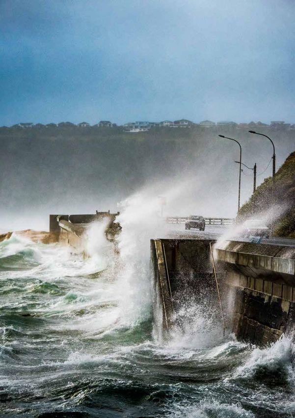
Damage to a house at Ruby Bay caused by ex TC Fehi. Inundation depth is surveyed at each
property, along with detailed damage and loss estimates. Photo: Ben Popovich, NIWA.
EX-TROPICAL CYCLONES
IMPACTING NEW ZEALAND
By RICHARD TURNER, RYAN PAULIK, AND BEN POPOVICH
The passage of ex-tropical Through March 2018, weather events A look back at historical records (Table
caused at least $123 million in insured 1) confirms that 2018 has been unusual
cyclones Fehi and Gita, in
losses ($57 million due to Fehi and Gita), (so far) for ex tropical cyclone activity
a backdrop of the hottest while in 2017 insured losses due to and impacts in several respects. First,
summer on record and weather events were $224 million with in terms of the number of events: 3 ex
$109 million due to ex tropical cyclones TC events compared to the long-term
a marine heatwave, had
Debbie and Cook. Ironically, Debbie was average of less than 1 per year (and 0.7
widespread impact and were the least intense but caused the most ex TC events for the entire period of 1960
a notable start to 2018. insured losses ($91 million) due to the to 2018); Second, the number of ex TC
breach of the stopbank resulting in the events crossing the South Island, which
Edgecumbe floods. was 2 in the past year compared to the
34EX-TROPICAL CYCLONES IN NEW ZEALAND
Debris deposits at Ruby Bay as a result of ex-TC Fehi. The extent of debris helps researchers
determine the run-up during an inundation event. Photo: Ben Popovich, NIWA.
long-term average of 1 every 5 years; Christchurch, Taranaki and Wellington and the University of Auckland is exploring
Third, the intensity of the events, with Fehi were particularly impacted. Fehi also this issue by using the results of very high
ranked 3rd equal and Gita 6th in terms of coincided with king tides associated with a resolution operational weather models to
how low the central pressures were; Last, blue-super moon, and this brought severe produce accurate 4-dimensional high-
the earlier occurrence in the calendar year coastal inundation and coastal erosion resolution simulations of each storm that
(February & March), compared to previous along parts of the West Coast and in the has impacted New Zealand since 2014.
events. The recent decade has also seen Tasman district. Fehi’s winds also caused The data provide a wealth of rigorously
the highest number of ex-tropical cyclones damage to buildings in remote parts of the comparable information on storms that
impact New Zealand in any decade since West Coast. can be applied directly to impact and loss
the start of reliable records in the 1960’s, models. Such information has never been
A NIWA team led by Ryan Paulik and Ben
though we could possibly extend this available before and is simply not available
Popovich surveyed the damage from
as far back as 1910 based on database from coarse-scale reanalyses, historic
coastal inundation on 20 properties in the
records from the USA National Oceanic weather event catalogues, or Tropical
Tasman district. A key research question
and Atmospheric Administration (NOAA; Cyclone track datasets. An example of the
was to see whether the wave action and
see Table, p.37). It is interesting to note the quantum leap in the level of information
debris movement would result in different
variability from decade to decade and how available from this modelling can be seen
levels of damage when compared to similar
much more intense and frequent the recent in Figure 1 (next page). It is hoped that
inundation from river-flooding. Preliminary
events have been. This raises questions future research will create this level of
analysis suggests that only minimal
about what role the unusually high Tasman information for each ex-tropical cyclone that
differences are seen, which is useful as
sea temperatures had in maintaining the has impacted New Zealand since 1960.
it allows vulnerability models developed
intensity of Fehi and Gita, and whether this This will allow us to examine the impacts of
for flood inundation to be applied to
is a mechanism by which New Zealand sea surface temperatures on the role of the
coastal inundation events without a loss of
might be more exposed to extreme intensity of the 2018 storms and provide
accuracy.
weather under climate change. a detailed baseline for interpreting the
Each ex-tropical cyclone is unique in terms impacts of future tropical cyclones.
Fehi and Gita were notable for their impact,
of its path, rainfall, storm-surge and wind
causing widespread damage across New Contact:
patterns, so the magnitude and types
Zealand, resulting in state of emergency
declarations for several regions. The
of impact can vary hugely from storm Richard Turner
to storm. Another current and exciting NIWA
West Coast, Nelson/Tasman, Kaikōura,
research project between OPUS, NIWA, Richard.Turner@niwa.co.nz
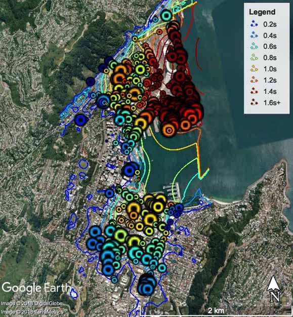
35NATURAL HAZARDS | 2017 Fig 1. Maximum surface 3-sec gust over the four year period of 2014-18 associated with the passage of ex-TCs over and near New Zealand. Gust speeds are shown as a colour scale in the side bar. The letters specify which storm caused the largest gust in each location during this period: Ita (I), 99P, Pam (P), Victor(V), Cook (C), Donna (D), Fehi (F), Gita (G), Hola (H), and the 10 April 2018 Auckland wind storm (A). As an example, high winds from Pam were over a large area of sea, but on land only from East Cape to Gisborne. Inset: For the period 1960-2018, the average number of hours per year in which the centre of an ex-TC was within each latitude-longitude cell around New Zealand. Note that the upper North Island has been particularly affected by ex-TCs during this period. 36
EX-TROPICAL CYCLONES IN NEW ZEALAND

   Decade                       Names of storms impacting                                 Number /                          Lowest Pressure
                                or tracking close to NZ                                   [number                           while centre within NZ
                                                                                          crossing                          latitudes (hPa). These
                                                                                          South Island]                     are generally not
                                                                                                                            available prior to 1970.

   1910-1919                    HD-1910, HD-1911, HD-1912,                                          9 [0?]
                                HD-1916, Zephon, Stentor,
                                3 un-named.

   1920-1929                    HD-1922 (2), 6 un-named                                             8 [0?]

   1930-1939                    3 un-named (includes storm of                                       3 [0?]                  ~970, 1936 storm
                                century in 1936)

   1940-1949                    HD-1948, 2 un-named                                                 3 [0?]

   1950-1959                    HD-1950 (2), HD-1951, HD-1952,                                      10 [2]
                                HD-1956, Ida, 4 un-named

   1960-1969                    HD-1961, HD-1963 (1+Henrietta),                                     9 [4]                   (965 - Gisele)
                                Barbari, Gisele (Wahine), Audrey,
                                Dinah, 1 un-named

   1970-1979                    Nessie, Alison, HD-1976 (Watorea),                                  6 [2]                   997, 980, 980, 997, 980,
                                HD-1977 (Norman), Hal, HD-1979                                                              980
                                (Henry)

   1980-1989                    NZ-1980(2, Simon, Sina), HD-                                        4 [2]                   985, 997, 975, 990
                                1987(Patsy), Bola, Harry

   1990-1999                    Damian, Esau, Fergus, Drena,                                        5 [2]                   992, 980, 979, 981, 990
                                HD-1998 (Yali), Frank

   2000-2009                    Ivy, NZ-2006 (Wati)                                                 2 [0]                   980, 995

   2010- 2018(*)                Zelia, Wilma, Evan, June, Lusi, Ita,                                15 [3]                  987, 978, 997, 987, 984,
                                Ola, Pam, Victor, Debbie, Cook,                                                             971, 997, 962, 991, 994,
                                Donna, Fehi, Gita, Hola                                                                     979, 992, 971, 977, 990

Listing of ex-tropical cyclones with NOAA’s SPEArTC database that has tracked close to or over New Zealand since 1910. The list has also been augmented by comments
from NIWA’s historical weather event database and 2017/18 Southwest Pacific tropical advisories. Storms with notable impacts are in bold and numbers crossing the
South Island are in square brackets. Numbers are less reliable prior to 1970, and central pressures generally not available prior to 1970. Note in the bottom row (2010-
2018), 99P is not included.

                                                                                                                                                                      37
You can also read