Water sharing schemes: insights
from Canterbury and Otago
←
→
Page content transcription
If your browser does not render page correctly, please read the page content below

Water sharing schemes: insights from Canterbury and Otago
Water sharing schemes: insights from Canterbury and Otago

Martin Ward

Environmental consultant

Shona Russell

Landcare Research

Prepared for:

Foundation for Research, Science and Technology

PO Box 12240, Thorndon, Wellington 6144

August 2010

31 Moncks Spur Road, Redcliffs, Christchurch 8081

Landcare Research, Gerald Street, PO Box 40, Lincoln 7640, New Zealand, Ph +64 3 321 9999,
Fax +64 3 321 9998, www.landcareresearch.co.nz
Reviewed by:                                          Approved for release by:

James Lennox                                          Michael Krausse
Senior Researcher                                     Science Team Leader
Landcare Research                                     Sustainability & Society

Landcare Research Contract Report:                    LC0002

                    © Landcare Research New Zealand Ltd 2010
                    No part of this work covered by copyright may be reproduced or copied in any form or
                    by any means (graphic, electronic or mechanical, including photocopying, recording,
                    taping, information retrieval systems, or otherwise) without the written permission of
                    the publisher.
Contents
Summary................................................................................................................................ v
1 Introduction .................................................................................................................. 1
2 Research Approach ....................................................................................................... 3
3 Background ................................................................................................................... 4
3.1 Legislative changes ......................................................................................................... 4
3.2 Changing government involvement in water sharing schemes ........................................ 5
3.3 Arrangements for water use and distribution.................................................................. 7
4 Drivers for water sharing ............................................................................................... 9
4.1 Canterbury ................................................................................................................... 10
4.2 Otago ........................................................................................................................... 11
4.3 Summary of drivers....................................................................................................... 12
5 Case studies ................................................................................................................ 13
5.1 Canterbury: Te Ngawai Water Users Group................................................................... 13
5.2 Canterbury: Ashburton–Lyndhurst Irrigation Company ................................................. 14
5.3 Canterbury: Opuha Water Partnership .......................................................................... 16
5.4 Otago: Kakanui Allocation Committee & Friends ........................................................... 18
5.5 Otago: Maniototo Irrigation Company .......................................................................... 21
5.6 Summary ...................................................................................................................... 23
6 Conditions for success for water sharing schemes....................................................... 27
6.1 Community-based leadership ....................................................................................... 27
6.2 Local identity ................................................................................................................ 28
6.3 Shared knowledge and development of trust ................................................................ 28
6.4 Reliable and up-to-date information ............................................................................. 29
6.5 Good relationships with regulators ............................................................................... 29
Landcare Research Page iiiWater sharing schemes: insights from Canterbury and Otago
7 Discussion ................................................................................................................... 30
7.1 Other institutional responses ........................................................................................ 30
7.2 Insights from Social Capital ........................................................................................... 34
8 Conclusions ................................................................................................................. 35
9 Acknowledgements ..................................................................................................... 36
10 References .................................................................................................................. 36
Page iv Landcare ResearchSummary
Project and Client
This report presents findings from an examination of the development of communal
irrigation schemes to understand characteristics of their formation and operation that
might inform future development of such schemes. It was prepared in 2010 for the
Foundation for Research, Science and Technology, and end-users of the Old Problems
New Solutions Project 1 (C09X0702). Old Problems New Solutions examines how
researchers and policymakers work together with water users and communities for the
governance for sustainable management of water resources.
Objectives
Our research sought to find out:
What drivers have shaped the development of water sharing schemes?
What are the characteristics of these water sharing schemes?
What are some of the conditions that have been important in the development of
schemes?
Approach
The project examined the development of water sharing schemes for irrigation in
Canterbury (Te Ngawai Water Users Group, Ashburton–Lyndhurst Company, and the
Opuha Water Partnership) and Otago (Kakanui Water Allocation Committee and
Maniototo Irrigation Company).
The findings presented in this report are informed by interviews with key individuals
linked to those groups and staff from regional councils to identify these conditions.
The insights from interviews are supported by insights from literature about the
historical development of irrigation and the primary sector in New Zealand.
Findings
Water sharing schemes have developed in response to drivers such as:
Desire for more reliable supply of irrigation water
Pressure from new irrigators for water allocations
Challenge to regional councils of monitoring thousands of individual consents
Increasing awareness of the need for more active management of water
resources
1
See http://www.landcareresearch.co.nz/research/programme.asp?Proj_Collab_ID=94
Landcare Research Page vWater sharing schemes: insights from Canterbury and Otago
Over-allocation of surface water resources leading to extreme low flows in
some rivers
Shortcomings in early planning and consenting, especially around
environmental flow volumes
Characteristics of the schemes differed with regards the origins of the scheme, whether
storage was available, whether water sharing or rostering arrangements were in place,
and the sources of water supply for each scheme.
Other factors such as the development and management of relationships both internally
between members of the scheme, and externally, with regulators and other
stakeholders, and the use of telemetry have been important in the management of both
the water sharing scheme and on-farm irrigation.
We identified a set of „conditions‟ that have been important in the development of these
schemes and that are likely to be so in the future:
Community-based leadership
Local identity
Shared knowledge
Reliable and up-to-date information
Good relationships with regulators
Conclusions & Recommendations
The research has identified a range of development pathways for water sharing schemes
from those that originated from historic mining rights to others that were formed in
response to Environment Court decisions.
Trust relations within schemes and with others, particularly regulators, are increasingly
important especially as there is a move from regulation to collaboration for the
management of New Zealand‟s water resources.
Further research could examine
Development pathways of water user groups in other parts of the country
Impacts of changing nature of relationships between schemes and regulators,
such as in relation to monitoring of water abstraction, influences the
development of water sharing schemes
The linkages between the development of water sharing schemes with other
collaborative responses to water management and how such collaboration will
be supported by government agencies, regulators and the irrigation industry.
Page vi Landcare Research1 Introduction
Water is vital to land use activities. Reliable access to water for stock and irrigation is
particularly important to agricultural activities in New Zealand. In dry or drought-prone
areas, a reliable water supply enables farmers to increase and maintain stock numbers and
helps ensure crops mature to harvest in profitable yields. In response to the need for reliable
supply of water, water sharing schemes have developed allowing for irrigation. In 2001,
irrigation schemes serving from 500 to 30,000 ha provided irrigation water to farmers over
more than 165,000 ha in New Zealand (MAF 2001).
This report presents findings from an examination drivers and conditions that have been
important in the development of water sharing schemes in Canterbury and Otago. The report
was prepared in 2010 for the Foundation for Research, Science and Technology, and other
end-users of the Old Problems New Solutions Project2 (C09X0702). The research has been
conducted as part of a research programme (Old Problems New Solutions 3) that examines
water governance in New Zealand focusing on the emergence of innovative responses to
water management challenges.
Water sharing schemes have developed as communal or community responses to water
challenges, sometimes alongside individual resource consents for water and the building of
on-farm storage. „Communal irrigation schemes‟ are described as „the grouping together of
people to share in the collection and distribution of water into a defined community of
interest‟ (MAF 2001).We use the term „water sharing schemes‟ to describe response to water
challenges that incorporate water sharing arrangements for water use, most often for
irrigation.
Here, we examine the drivers and conditions that have been important for the development of
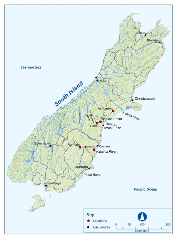
five schemes located in Canterbury and Otago (see Figure 1) – two regions with the largest
areas of irrigable land in the country. We identify the diversity of characteristics of water
sharing schemes to illustrate the range of different pathways current, and future, schemes
could develop. We have positioned the developments of these schemes in the context of
similar collaborative initiatives in both regions that are emerging in response to challenges
with land and water management 4.
2
See http://www.opns.landcareresearch.co.nz for further information
3
This research was conducted as part of the Old Problems, New Solutions project that examines decision-
making for sustainable management of water resources. Other parts of the research project examine governance
arrangements (Gunningham 2008, unpubl. report); participation in decision-making (Russell & Ward 2010);
deliberative processes for water management (Lennox et al. forthcoming) and sustainability appraisal of water
strategy options (Russell & Ward 2010; Jenkins et al. forthcoming).
4
Other examples of collaborative responses to aspects of water management include the Land and Water
Forum, Canterbury Water Management Strategy, and efforts by regional councils to support water user groups
e.g. the Upper Taieri Project in North Otago. See section 5.7 for further discussion of these groups.
Landcare Research Page1Water sharing schemes: insights from Canterbury and Otago Figure 1 Locations of water sharing schemes in Canterbury and Otago. Page2 Landcare Research
Water sharing schemes: insights from Canterbury and Otago

2        Research Approach
Research was conducted between November 2009 and February 2010. During that period, we
reviewed literature and policy documents to understand the context in schemes have
developed; and one of the researchers (Martin Ward) conducted interviews with key
individuals connected to these schemes and water user groups.

The review of previous work involved searching for literature and policy documents on
databases, websites and asking individuals to recommend documents. Previous research had
examined the social impacts of irrigation schemes (McCrostie Little & Taylor 2001), water
transfer (Lang et al. 2006, 2008), and the changing administration of schemes (Collins et al
2001, Le Prou 2007). While various presentations 5 and papers written by a range of
individuals engaged in various aspects of water management in New Zealand with regards
water allocation (Jenkins 2007), water security (Heiler 2009) and community-led water
management (Newman & Robertson 2010) provided useful insights into the current
developments in water sharing from perspectives of regulators, irrigation industry and
community groups.

We identified five schemes in Canterbury and Otago regions as examples of community-
based groups coming together to share water – primarily for irrigation. We approached
irrigation industry organisations and irrigation schemes via telephone to describe the project,
the objectives and intended outputs; and to request interviews with particular individuals or to
seek recommendations about whom to interview. We identified key informants as those
individuals who were leaders with experience of the particular schemes and who had an
understanding of the context and technical details of schemes. We also identified other
informants from regional councils and interviewed them on the basis that some water scheme
consent conditions stipulate that irrigators must engage with stakeholders while others have
ongoing relationships with regional council staff in related aspects of water management.

We developed an interview schedule to identify and examine the drivers of the schemes‟
respective developments; the conditions that have been important for their development and
the characteristics of these schemes. We conducted 21 face-to-face interviews between
December 2009 and February 2010 with key informants from schemes and regional councils.
In some cases individuals were happy to meet alone and in other cases interviews were held
with two members of an irrigation group. Some interviews were repeated with key informants
to clarify points. After interviews were completed we sought verification of our descriptive
analysis of the scheme, clarification of details, and further comments from participants.
Interviewees also discussed „big picture‟ issues including developments in corporate farming,
changes in rural communities, and long-term impacts and benefits of changing farming
practices that provide a context in which to understand the development of water sharing
schemes.

5
    Such as the Water Infrastructure Forum in December 2008, Christchurch.

Landcare Research                                                                                        Page 3
3 Background Voluntary water sharing schemes for irrigation began in New Zealand in Central Otago during the late 1800s using dams, races and other facilities originally developed for gold mining (see Box 1 below). Using a method referred to as „wild flood‟, these activities were owned and operated by individual farmers or groups of farmers. Since then other schemes have developed with government and private involvement. More recently, water user groups in other regions, such as Hawkes Bay, are exploring options for water sharing schemes. Here we present an overview of some of the factors and changes that have occurred concerning legislative changes, degrees of government involvement in the schemes prior to giving an introduction to types of arrangements that are common amongst the schemes. Mining Privileges in Central Otago The first water sharing schemes in Central Otago secured water through the Mining Act 1898 which provided for the issue of ‘mining privileges in respect of water’ for terms of up to 42 years. These privileges were issued for mining gold with little, if any, assessment of actual stream flows available (Otago Regional Council, 2007). They were divisible and transferable and were widely issued in Otago, especially in Central Otago. A system of priorities attached to the issue of these permits such that the ‘first in time means the first in right’ allowing one deemed permit holder to take all the available water leaving no downstream flow for other water users or to maintain aquatic habitat. When accumulated the rights exceed available river flows in parts of Central Otago (Heiler 2009). 3.1 Legislative changes The Mining Act 1898 is just one piece of legislation that has been formative in the development of water sharing schemes. Table 1 below summarises some of the legislation that been influential in the development of schemes with regards the purpose or origins of the establishment of water sharing schemes as an engineering project first and foremost rather than one that enables ongoing diversification of land use by farmers as is the case with the Public Works Act 1928. Other legislation provided for rights to use water and changed the terms and conditions of the mining privileges first granted in the late 19th century, as well as the changing how irrigation schemes were financed and who paid for different aspects of the water sharing schemes. Government funding applied only to capital works to take the water from the river source, for canals and, where used, storage dams. On-farm distribution costs were not funded by the government. The rationale for government involvement in irrigation investment rested on the schemes being too large and investment horizons too long for individuals acting alone. Furthermore, government involved in these large scale scheme developments were seen to provide employment in agricultural production (Farley & Simon 1996) and more specifically in the Depression years of the 1930s scheme development enabled gainful employment of unemployed persons in public good works programmes. Page 4 Landcare Research
Water sharing schemes: insights from Canterbury and Otago

Table 1 Legislation and water sharing schemes

Public Works Act      Legislation treated early scheme development as an engineering project with poor
1928                  provision for the wide ranging changes that had to be made by landholders.
Water and Soil        This was the first comprehensive water management legislation which provided for rights
Conservation Act      to take and use water for the use of individuals, companies and the Crown. Most early
1967,                 schemes outside Otago were developed under this legislation. An amendment to the Act
                      in 1971 provided for the term of mining privileges held by the government or a local
                      authority to continue in perpetuity.
Public Works Act      This Act introduced a statutory basis for calculating water charges. The legislation
1975                  provided for a two-part water charge: a ‘basic charge’ levied on all irrigable land within
                      the scheme (regardless of whether it was actually being irrigated) to recoup a portion of
                      capital costs, a ‘water availability’ charge, payable when water was available to be taken
                      from the schemes, and an ‘overhead ‘amount to cover operation and maintenance costs
                      (Farley & Simon 1996).
Irrigation Scheme     This Act established authority ‘to dispose the irrigation projects and eliminated all
Act 1990              statutory provisions for irrigation. In addition, the Act provided for the transfer of
                      existing access rights held by the government to new owners; and provide for the
                      transfer of existing government-held water rights to the purchasers’. The legislation
                      addressed each scheme to be ‘sold’ to private owners, detailing the assets and essential
                      elements of the scheme arrangements.
Resource              This Act legislates for the allocation of water and provided for Irrigation Company Public
Management Act        Works Act rights to terminate in 2001 and mining privileges to cease in 2021. It specified
1991                  that all water rights issued under other earlier legislation are to expire on 1 October 2026.
                      This legislation established new procedures and rules governing water use, with regional
                      councils playing a leading administrative role with catchment studies and consenting
                      water takes.

3.2      Changing government involvement in water sharing schemes

Government involvement in water sharing schemes began in 1910 with public financing of
12 irrigation projects in Central Otago before the end of 1935. The government purchased or
appropriated many of the mining privileges and developed larger irrigation schemes, often
involving dam-contained storage. After 1935, government-financed construction of irrigation
projects was extended to other areas of the country with the eventual construction of 40
irrigation projects in the South Island and 9 in the North Island. The great majority of
schemes utilised border-dyke irrigation methods for pastoral farming, mostly sheep

During periods of higher government involvement, the Ministry of Works6 designed,
constructed and operated the government-owned irrigation schemes and had the
responsibility for determining annual water charges. These were paid by water users to cover
operation and maintenance costs plus the interest costs associated with a quarter of the capital
cost associated with headworks and distribution facilities (Farley & Simon 1996). A number

6
    Later to become the Ministry of Works and Development.

Landcare Research                                                                                          Page 5
of schemes involved some electricity generation, an activity that was managed by the government for use in the national grid. Following a shift away from active government participation in the economy during the economic reforms of the 1980s, Fifty-two government-owned irrigation projects, ranging in size from 100 ha to >20 000 ha and involving from three to over 300 individual irrigators, were put up for sale. The projects were sold in their existing condition, which in many instances reflected significant deferred maintenance and which resulted in the government paying the irrigators to accept the assets. Water rights held by the government were transferred to the projects on existing terms and conditions except that the remaining terms were limited to 30 years from the date of sale. The new owners of the irrigation schemes established co-operatives or incorporated societies with office holders elected from amongst their numbers. Formal water supply agreements were put in place and race men employed to operate the schemes day to day and for maintenance. The privatisation of the Ministry of Works and Development‟s operations in 1988 (the source of government hydrology and engineering expertise central to irrigation development) and the withdrawal of government from a central role in the economy was accompanied by a swift and complete withdrawal of subsidy support from almost all aspects of farming. There was a period of consolidation for voluntary water sharing schemes in the two regions with little irrigation development. More recently, individual irrigation schemes have developed comprising mainly groundwater abstraction and with increasing emphasis on spray irrigation of various types. Four large community irrigation schemes developed by farming interests are the Downlands, Opuha, Benmore and Waimakariri schemes. The Maniototo Irrigation Scheme was extended during this period as well. Two others with resource consents but that have yet to be constructed are the Central Plains and Barrhill–Chertsey schemes. All schemes had some form of underwriting of capital cost either by the local council, an electricity company or significant shareholder investor. While schemes were built, there was slow uptake in on-farm irrigation in the first half of the twentieth century which is attributed to a „failure to provide reference to farmers‟ needs and expectations meant that irrigation development on-farm was completed very slowly and therefore there was under-utilisation of the resource for many years‟ coupled with increased annual costs both operational and maintenance for the infrastructure, and farmers‟ unwillingness to pay additional costs (MAF 2001). By the mid-1950s, there was a realisation that development of water sharing schemes required prior commitment and involvement by farmers and others with regards both the costs and involvement from the start. Farmers had to be involved and fully informed of expected financial responsibilities in the future, the possible benefits that they would gain from irrigation leading to active involvement of farmers in the promotion and implementation of schemes as well as the increased provision of advice and research on irrigation practices and farm management benefits (MAF 2001). Increasingly, local government had an important and active role alongside their communities in the development of water sharing schemes. Local and regional government have contributed technical advice, labour and machinery as well as acting as an advocate and mediator between the community and Central Government as evidenced during the development of the Rangitata Diversion Race (see McCrostie Little & Taylor 2001 and information in section 6.2). In addition, in recent years MAF‟s Sustainable Farming Fund has supported community groups by giving information and advice on irrigation illustrating Page 6 Landcare Research
Water sharing schemes: insights from Canterbury and Otago

the ongoing relationships between government agencies and farmers that are important in
scheme development.

3.3    Arrangements for water use and distribution

Seasonal fluctuations in surface water and hydraulically connected groundwater and the need
to ensure water is available in alignment with crop growth cycles and seasonal-long demand
for pasture associated with land use intensification and growth in arable and dairy farming
has led to the development of various arrangements for the use and distribution of water both
on-farm and across water sharing schemes. The majority of water sharing schemes in
Canterbury and Otago involve taking water directly from rivers and hydraulically connected
groundwater. These sources of water are subject to seasonal fluctuation. Restricting water
use on farms as surface water flows diminish or groundwater levels decline provides
challenges and stress for on-farm management. Schemes that take water direct from rivers or
ground water, and those with storage require arrangements for the distribution and use of
water, particularly when managing depleted flows in summer.

The rapid increase in individual irrigation takes (since 1999) has driven another type of water
sharing scheme. These arise from groups of individual irrigators seeking takes from surface
or hydraulically connected groundwater from a particular stretch of a river. Sharing
arrangements are increasingly being imposed by regional councils as the councils have
sought innovative ways of meeting the demand for irrigation water while managing the
collective impact on river flows of new and existing irrigators. The new form of communal
arrangement is to help ensure an equitable distribution of the water resource between
abstractors, and between them and the environmental needs of the rivers. These arrangements
are generally imposed through the regulatory system with conditions on individual and
groups of consents.

Rostering of water supply (or take) or restrictions on takes are the common arrangements
used7 in the use and distribution of water. Decisions about when to use, and distribute, water
requires reliable and timely river flow information as well as some basis for distribution.
Telemetry technology provides tools to monitor river flows guide individual farming, and
distribution decisions across the scheme; while collaboration between consent holders sharing
the same restriction arrangements as a result of their location (on the same tributary or stretch
of the river) or consent type (restricted class of consents) offers the basis for „distribution‟ of
water take opportunities to meet individual as well as communal needs.

In the larger schemes, when diversion or dams are involved, water supply to individual
irrigators is subject to arrangements established by the parent entity through water supply
agreements (WSA). These agreements (or irrigation deeds) set out details of how and how
much water is to be made available, what time of year and at what cost it is to be delivered.
Water supply agreements for different schemes have developed from the common model
established by the Ministry of Works but with some differences depending on the type of
scheme (see Table 1).

7
 Resource consents commonly have a two-step response to diminishing flows – step 1 to go to 50% reduction,
step 2 to full restriction, i.e. no abstraction.

Landcare Research                                                                                     Page 7
Table 2 Examples of rostering arrangements

Type of scheme             Factors to consider in rostering arrangements
Communal irrigation        Rostering is used to share water demand
scheme
Larger dam or diversion    Roster must take into account the need to ‘push’ sufficient volume down the system
race schemes               to ensure irrigators towards the end of the system receive their allocation.
Run of river schemes       Rostering is to ensure river environmental flow levels are not breached

While the need for a roster, for normal delivery and restricted flow delivery, is identified in
the WSA, the roster itself sits outside the agreements as a management tool for amendment
from time to time as circumstances dictate. Well-designed rosters and close compliance with
roster „rules‟ is critical to the effective and efficient operation of the schemes. Commonly
individual irrigators are rostered to take a particular volume of water between specified times.
Taking water outside these times denies other irrigators their allocation, while failing to take
the water can result in flooding of roads and pressure on infrastructure.

In order for these WSAs to work, it is necessary to closely monitor and record water use. The
ongoing monitoring, recording and reporting of water use supports the ongoing information
base for decision-making about when and how to use and distribute water. In addition, this
body of information is likely to be more accurate than the regulators occasional compliance
monitoring, often in the form of spot-checks. The ongoing monitoring of water use by
irrigators, as users of water, could lead to the reduction of costs for both the regulators and
water user through the reduction in the need for additional monitoring by the regulator.

Rostering and monitoring are just some of the rules, informal and formal, that are in
operation in schemes. Other rules include restrictions on types of operations (for example not
„watering roads or pumping at times that are not agreed upon8), are often set down in the
incorporated society rules, water supply agreements, operations or operating policy manual.
Non-compliance to these rules can lead to penalties. One company reports that the rules are
not set down in any prescriptive way and would be best described as „common sense best
practice‟ set by the Board and notified to shareholders in newsletters9. These examples
illustrate the various ways in which schemes are developing arrangements for water use and
distribution in accordance with the unique characteristics of the schemes as illustrated in the
next section.

8
 In one scheme the penalties for early pumping or late shut off are on a 5-step scale commencing with a verbal
warning, followed by a written one, then 1 week‟s loss of water, then 3 weeks‟ loss, then loss of right to take at
all.
9
    Pers comm. Graeme Sutton

Page 8                                                                                       Landcare Research
Water sharing schemes: insights from Canterbury and Otago
4 Drivers for water sharing
Early irrigation projects were largely an insurance against drought against a perverse climate
rather than a production management tool. As dryland farming approached its upper stocking
limits under farm practices, the resilience of farm economics to withstand bad years
diminished. Irrigation provides the means of not only overcoming drought but creates
opportunities to intensify and diversify land uses. Irrigation technologies such as spray and
sprinkler systems have led to the realisation of the full potential of water application
(McCrostie Little and Taylor 2001). Initially the majority of irrigation and stock water
schemes were „communal‟ because they needed the collective use of the water, to justify the
capital involved. It was only when well-drilling and pumping technology improved that it
become practicable for an individual farm to irrigate from its own resources.
While surface water was a common source of supply, groundwater use for irrigation started
in the 1960s and more recently has increased with the rapid expansion of irrigated dairy
farming onto light soils previously thought suitable only for extensive dry stock farming
(Weeber et al. 2001). The development of more sophisticated irrigation methods, and in
particular the move to spray irrigation, introduced the need for supply certainty. This has
resulted in a trend towards on-farm or scheme storage.
Water allocation in New Zealand increased by 50% between 1999 and 2006 mainly as a
result of an increase in the area of irrigated land (MfE 2007, p. 262) with allocation in
Canterbury and Otago accounts for almost three-quarters of the country‟s total allocation.
The allocation and sharing of water are intertwined with the growth in irrigation technologies
and the area of land under irrigation. As water schemes have developed there have been
changes in land use and options for the sources of water supply have been created through the
development of different technologies. Notably, the security of water supply remains central
to the development of water sharing schemes. Many different drivers have led to individuals
coming together to discuss how water can be shared and managed for collective interests in
response to a range of different concerns ranging from drought protection to job creation as
summarised in Table 2 below.
Table 3 Changing governance concerns for irrigation (Collins et al 2001)
Era Dominant governance concerns Locations of new schemes
1910 – Drought protection Central Otago
1934
1935 – Job creation Canterbury
1949 Drought protection
Desire to put water to work
1950 – Need to review schemes Canterbury
1960 Greater cost sharing Central Otago
1961 – National economic interest South Island
1984 Farm management tool Upper North Island
Post – 1984 Improve efficiency A small number in diverse locations proposed before
End subsidisation 1984
Privatisation through sale to
irrigators
Landcare Research Page 9Having given an overview of the concerns of water haring schemes generally, the following sub-sections introduce aspects of water governance for Canterbury and Otago, leading to the identification of drivers for such schemes. 4.1 Canterbury Environment Canterbury (ECan) is the regional council with responsibilities for the management of Canterbury‟s water resources through the allocation of water resources through resource consents and the setting and adjustment of river levels. In Canterbury water resources are widely believed to be over-allocated (Jenkins 2007; Heiler 2009). However, actual use is believed to be between 50% and 70% of allocations on average (Heiler 2009). The region faces challenges in the form of the number of individual consents for water takes currently standing at over 6300 (James Palmer pers. comm.) with many consents covering more than one extraction point; and river flow levels below environmental flow levels commonly occur in rivers such as the Ashley, Waipara, Waikari, Selwyn and the Irwell. The year-on-year decline of groundwater reservoir levels and lowland and foothill river flows during irrigation seasons and increased competition for water through allocation processes leave few in doubt that the water resource has reached or exceeded sustainability levels. Establishing and operating an effective region-wide programme to measure and monitor water takes and ensuring compliance with various consent and plan limits is a huge job and while there has been good recent progress with the development of the Canterbury Water Management Strategy Strategic Framework and the establishment of the zonal and regional committees which have respective responsibilities to develop water management implementation programmes. Alongside the development of a regional strategic framework, water allocation decisions are increasingly considering the management of environmental flows and flow variation as part of responses to maintain in-stream ecological and recreational values; and telemetry is being used to record and report on flows. Ensuring an effective network of flow recorders with telemetry for real-time reporting is not subject to the lengthy delays that RMA procedures impose on environmental flow setting. Recent trials of telemetry of water use data have reinforced the potential for consent holders to actively manage their own resource use. Such management by consent holders avoids onsite readings thus reducing compliance monitoring costs. Furthermore, water use data can also be integrated with other data such as low-flow sites, climate and soil moisture data which when integrated can be used as an effective on- farm management tool to reduce overall running costs (ECan 2005) for consent holders. Page 10 Landcare Research
Water sharing schemes: insights from Canterbury and Otago

4.2    Otago

       Demand for water has increased and there is a clear trend of decreasing flows in the Kakanui
       catchment during the irrigation season over time, despite no observable changes in rainfall
       trends. This is presumed to be an increase in water use intensity associated with an increase in
       intensive farming practices such as dairy farming that have a higher demand for water.

       (Otago Regional Council 2007).

In Otago, water allocation and use for irrigation has a number of particular challenges
relating to its history and changing land uses as the quote above identifies. Like Canterbury
and other regions to a greater or lesser degree, there are some legacy issues arising from
inadequate or incomplete hydrologic information on many rivers and lack of understanding of
the connectivity between groundwater and surface water. Throughout the region, water
sharing schemes for irrigation are reliant on water storage dams and old mining races, as well
as individual irrigators having access to local water10.

Otago Regional Council is the regional council responsible for water management and the
region‟s current response builds upon the historical rights to take water associated with
„mining rights‟ (see Box 1), the „permissive‟ allocation of water under the Water and Soil
Conservation Act, and finally the „first come first served‟ allocation under the RMA. The
changing legislation and the absence of adequate catchment planning have resulted in many
Otago rivers being over-allocated11.

The origin of the majority of water permits originally issued for mining activities (sluicing,
etc.) under the Mining Act 1898, over 100 years ago in Otago (see Box) is the most
significant driver for innovative and community-based management of water schemes. These
permits cease to exist in 2021 and the regional council needs to establish replacement
arrangements not just for individual water takes but also for a variety of water sharing
schemes that have emerged over time associated with the mining rights. The informal and
formal arrangements are outside the regulatory framework and would require complex and
individual rules to bring them into a regional water plan.

The Otago Regional Council (2008a) has provided for Water Allocation Committees (WACs)
in the Otago Regional Plan: Water to address the rationing of water takes when water is
approaching minimum flows or aquifer restriction levels are in place. The WACs are
established under a condition of resource consents and the consent holder must comply with
restrictions set by the WACs. The WACs are subcommittees of the Regional Council; created
under the Local Government Act, and subject to that Act. Every 3 years, the subcommittee
must be reappointed by the Council, which provides some administrative and compliance
support. By devolving decision-making to schemes allows the arrangements to be renewed

10
   David Hamilton „Otago Irrigation Presentation‟ at Water Infrastructure Forum 20 December 2008
http://www.maf.govt.nz/mafnet/rural-nz/sustainable-resource-use/irrigation/water-infrastructure-
forum/presentation-02.pdf
11
  The 2009 ORC report „Water management and allocation into the future – A strategy for Otago‟, records,
„Most surface water in Otago, with the exception of the Clutha River/Mata-Au, is seriously over-allocated and
demand for water continues to increase.‟ (ORC, 2009).

Landcare Research                                                                                         Page 11
(or be changed) within broad guidelines established by mutual agreement and introduced by
plan change.
Alongside the development of a regional water plan and the devolution of decision-making to
water committees, the regional council has established environmental flow levels for only a
small number of Otago rivers. However, this is being addressed through a plan change
(Otago Regional Council 2008a, 2008b). Notably, deemed permit holders do not need to
abide by minimum flow restrictions.
4.3 Summary of drivers
In summary, water sharing schemes have developed in response to drivers such as:
Desire for more reliable supply of irrigation water
Pressure from new irrigators for water allocations
Challenge to regional councils of monitoring thousands of individual consents
Increasing awareness of the need for more active management of water resources (for
example through the setting of environmental flows)
Over-allocation of surface water resources leading to extreme low flows in some rivers
Shortcomings in early planning and consenting, especially around environmental flow
volumes
And particular to Otago:
The expiry in 2021 of deemed permits issued under the Mining Act.
The next section presents case studies of water sharing schemes and initiatives to aspects of
governance and management to identify factors that have been important for the development
of these schemes over time. While each scheme has faced different challenges with regards
drivers and characteristics in terms of scale, location, water availability and capital
availability, as illustrated below, there are some common factors that have enabled schemes
to develop as discussed in section 6.
Page 12 Landcare ResearchWater sharing schemes: insights from Canterbury and Otago
5 Case studies
Our investigation examines the development of water sharing schemes in Canterbury and
Otago (see Figure 2) to glean insights with regard to drivers, responses and future pathways
for action in local contexts involving a range of parties, including regulators and
stakeholders. Here we examine the development of the schemes with reference to how each
operates within the context of how allocation decisions are made by regional councils
5.1 Canterbury: Te Ngawai Water Users Group
Te Ngawai12 is a small true-right tributary of the Opihi River in South Canterbury. In 1999,
applications to take water from Te Ngawai River were submitted under the RMA following
the need to renew rights for irrigation under the Water and Soil Conservation Act 1967.
Environment Canterbury, the regulatory authority, considered the consent applications as a
group at a notified hearing in 2001. Consents were issued with conditions that restricted the
five applicants to ensure the river flow did not fall below a minimum flow level measured
downstream of the lowest abstractor. Once minimum flow levels were reached, restrictions
would then be applied.
Subsequently, the applicants appealed to the Environment Court regarding the conditions on
the consents, and they proposed to collaborate in a water sharing scheme. On the basis of an
Environment Court ruling, the consents were issued in 2003 to the applicant irrigators. The
consents were identical and the Tengawai [sic] Water Users Group was identified as the
named holder of the consents rather than the individual applicants. The informal group was
formed as part of consent conditions without incorporation or other formal organisational
structure.
The consent conditions also specify the rates at which the irrigators can pump water from the
river or hydraulically connected groundwater in nearby gravels, the minimum flows during
three periods of the year; and rule that irrigation restrictions will be imposed when river flows
drop to, or fall below, those levels. Finally, the conditions directed the group to install
approved measurement, data-logging and telemetry equipment on irrigation pumps. This
water sharing scheme does not involve water storage and there is no rostering of water takes
unless ECan has put water restrictions in place. This scheme would limit the combined rate of
abstractions in the event that the flow reached minimum flow levels to ensure minimum flow
requirements are not breached.
The group has developed an allocation and rostering system that controls who takes water
during periods when full abstraction would result in non-compliance. The members meet
annually and elect a chairperson whose responsibilities include liaising with the regulator and
direct compliance action in response to the low-flow trigger. The established rationing
procedure in the group is day-on/day-off rostering, although there is flexibility to negotiate
different short-term arrangements subject to collective agreement. There are two steps down
on restriction, initially to 50% then cease pumping.
12
Te Ngawai is the correct spelling of the name formerly and commonly written (and pronounced) Tengawai.
Landcare Research Page 13Environment Canterbury installed telemetric data transfer equipment to enable compliance
with consent conditions as part of a regional trial of equipment and the collection and use of
information gathered. Since November 2005, the group has been able to access the
information gathered from a consultant‟s website along with information on climate, soil
moisture, low flows and dam levels that are available on the ECan website 13. This gives
consent holders continuous access to information that informs decisions about irrigation.
The telemetry trial was designed to allow these farmers to maximise the use of their allocated
water either on an on-farm basis or collectively as water user. In both cases, instantaneous
data were required to ensure that the farmers could manage the amounts of water taken and
be able to demonstrate a degree of compliance with their resource consents. The trial
highlighted a number of issues with flow meters (e.g. the meter type selected compromised
the measurement of flow) and farmers in the trial had intermittent access to data due to slow
Internet connections. One trial participant said he had seen no benefit from the technology as
yet mainly „because Internet access in the area was abysmal‟ (ECan 2006, p. 1).
The ECan-funded telemetry trial ended at the finish of the 2008/09 irrigation season.
Subsequently the Tengawai Group have not made alternative arrangements for data collection
and transfer, such as investing in more equipment or monitoring services with the help of
consultants. In the meantime, individual scheme members are now building on-farm storage
to secure supply. While such developments could reduce, and in some cases eliminate, any
incentive for further collaborative action, the high cost of water-harvesting dams in the
Tengawai area has resulted in farmers looking at technology to help them optimise their
opportunities for securing water when it is available.
5.2 Canterbury: Ashburton–Lyndhurst Irrigation Company
The Ashburton–Lyndhurst Irrigation Scheme straddles State Highway 77 between Methven
and Ashburton in Mid-Canterbury. The scheme was established with government
involvement and support and is one of three schemes 14 supplied by the Rangitata Diversion
Race which commenced delivering irrigation water in 1944 (see Box 2). As the second
largest irrigation scheme in New Zealand, the Ashburton–Lyndhurst scheme occupies
approximately 24 500 ha of land and has an allocation of 250 million cumecs [cubic metres
per second] of water delivered at 13.0 cm3/s. In addition to supplying irrigators, the scheme
also supplies the Ashburton District Council stock water race system and various private
stock water races.
It was originally designed and operated as boarder dyke irrigation for predominantly pastoral
farming. By 1986 all irrigable land within its reach was irrigated and the arrival of laser
levelling for border dyke construction enabled a widespread change of water use from
irrigation, from one of drought proofing to the use of irrigation as a farm management tool. In
pursuit of better returns and greater reliability, agriculture in the area is now dominated by
arable farming with increasing amounts of spray irrigation of one sort or another. In addition,
dairy farming has steadily increased over the years. In recent years demand for water storage
13
Environment Canterbury www.ecan.govt.nz
14
The others are Mayfield–Hinds and Valetta.
Page 14 Landcare ResearchWater sharing schemes: insights from Canterbury and Otago
has increased to meet the needs of centre-pivot irrigation methods, which require smaller
quantities of water to be applied on a more regular basis. Some farmers have developed on-
farm storage but the Ashburton-Lyndhurst Irrigation Company is in the process of purchasing
a farm suitable for the location of a dam for scheme-wide storage.
Box 1: The Rangitata Diversion Race
The Rangitata Diversion Race (RDR) commenced construction in 1937 as one of the schemes developed by the
3
Ministry of Works. It conveys approximately 34 cm /s of water from the Rangitata River through irrigation
canals across the Canterbury Plains to discharge into the Rakaia River. A second intake from the South
3
Ashburton River can divert an additional 7 cm /s of water when it is available. There are two electricity
generation plants along the RDR that use water when it is not required for irrigation.
The RDR ownership structure and operational arrangements were challenged by a number of legal changes
through the 1990s including changes to the ownership of its electricity generating entity, and changes to the
Local Government Act and the Companies Act. In 2002 a new constitution was formally agreed between its
then shareholders, the three irrigation companies, the Ashburton District Council and Trust Power, each with a
15% share. Twenty-five percent is held as B shares by Ashburton District Council for future allocation.
The Ashburton–Lyndhurst Irrigation Company (ASIC) is a limited liability company formed
in response to restrictions on raising capital for incorporated societies. The ASIC has six
directors appointed by the shareholders. It is generally agreed to be the most innovative and
progressive of the three schemes linked to the RDR scheme, which is a characteristic
attributed to farming leaders with tertiary education and more stable farm ownership in the
Ashburton–Lyndhurst scheme compared with the Valetta and Mayfield–Hinds schemes. Such
stability delivers financial security and long-term relationships enabling more enterprising
decisions.
Under original arrangements by the Ministry of Works, individual farms were allocated
8 cusecs (cubic feet per second) of water for 24 hours per week for every 80 ha of farm size 15.
Payment for supply is required whether the farmer takes the water during the irrigation
season or not. Rosters are used during periods of normal water and when restrictions are in
place. Rosters are prepared by the Head Race Man (increasingly known as the Operations
Manager) in the evening. The preparation requires good knowledge of race flow rates in
different parts of the extensive scheme. As river flows diminish, the RDR signals the
likelihood of restrictions 7 days in advance. Restrictions are also imposed in the scheme as
water volume reduces, to endeavour to continue to meet delivery frequency. The initial
restriction is a reduction by 20%. The Head Race Man has final say over rosters, which
decision can only be overruled by the Board. Roster discipline is important on this scheme.
Compliance with start and finish times ensures neighbouring irrigators can use water at times
allocated to them.
The water supply agreement addresses activities in and near the races, for example restricting
the grazing of cattle, controlling vegetation and the planting of trees. The agreement provides
for immediate cut-off in supply of water and removal of control devices for significant
breaches of the agreement. In practice minor breaches of the water supply agreement result in
forfeiture of one rotation of water.
15
Pers comm John Young
Landcare Research Page 155.3 Canterbury: Opuha Water Partnership
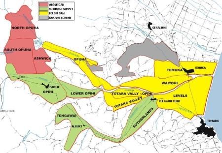
The Opuha Water Partnership (OWP) comprises the South Canterbury Farmers Irrigation
Society and Levels Plains Limited 16. The Partnership owns the Opuha Dam with an upstream
reservoir and downstream subsidiary pool on the Opihi River near Fairlie in South
Canterbury. The dam was developed by a group of local farmers with unreliable irrigation
water supply from the Opihi River which was over-allocated and prone to periods without
flow. It was completed in 1999 to optimise the water resource and includes a 7mw electricity
generator. The scheme was originally financed through shares sold to landowners in the area
that could be irrigated, with a $1 million government contribution for the establishment of
environmental flows.
Discharge arrangements are governed by a complex set of conditions on the OWP consents.
The dam operates to deliver water from the reservoir into the river to meet a hierarchy of
needs and opportunities. An environmental flow level must be met at all times requiring a
base flow plus augmentation to compensate for irrigation takes. Benefiting from the
augmentation flows in the Opihi River are three downstream irrigation schemes, Levels
Plains, the Totara Valley, and the Kakahu with a combined area of 9000 ha, plus 700 ha of
land is irrigated by individual consent holders taking water from groundwater hydraulically
connected to the river (Figure 3).
Figure 2 Land supplied by the Opuha scheme17.
16
These two organisations are in the process of being incorporated as Opuha Water Ltd.
17
From http://scfis.co.nz/map
Page 16 Landcare ResearchWater sharing schemes: insights from Canterbury and Otago The dam was completed in 1999 to supply water from the reservoir into the river to meet a hierarchy of needs and opportunities (e.g. irrigation and generate electricity). Today the dam, reservoir and weir pool are under daily management of Contact Energy, under contract to SCFIS. Contact Energy discharges water in accordance with environmental flow requirements, flow augmentation emergency (flood) and other operational requirements (flush flows), and for electricity. The Opuha Water Partnership is owned by the two irrigation companies but the partnership intends to form Opuha Water Limited 18 where farmers hold shares in the scheme directly rather than via the irrigation companies. The individual irrigators hold Water Supply Agreements (WSA) with either of the two irrigation companies and these agreements entitle irrigators to quota of water based on their shareholding. The agreement states that SCFIS will use its best endeavours to deliver the quota of water at a weekly rate for the irrigation season defined as 1 September to May 31 19. The volume and rate of delivery reflects the SCFIS water consent that sets an overall ceiling for both. The delivery clause is subject to an „as far as practicable‟ caveat. Supply is subject to availability and provision is made for „additional water‟ to be allocated when available through rostering. Individual irrigators are required to record the flow rate of water take and provide this information to SCFIS. Charges for the water are set annually and operate on a partial „take or pay‟ formula with 80% of the charge required irrespective of use. There are penalties for breaches of the agreement set in two steps: first, reducing, and second, cutting off the water supply. Individual irrigators submit orders for their water requirement with a volume specified together with a start and finish time. The assembled orders guide the release of water from the dam. Irrigators taking water from hydraulically connected groundwater above and below the dam have meters and submit log records of water taken to SCFIS, a requirement of the Opihi River Regional Plan. The scheme‟s operation together with other aspects of water use are subject to the Opihi River Regional Plan (ECan 2000)20, which has a complex set of resource consent types reflecting a history of takes and conditions from periods prior to and subsequent to the introduction of the RMA. All activities provided for in the regional plan are discretionary with the exception of the discharge of sewage, which is prohibited. The plan is due for review in 2010. The Opihi River Regional Plan established an Opuha Environmental Flow Release Advisory Group (OEFLRG) comprising one representative each for the dam, for stakeholders of in- stream values (appointed jointly by Department of Conservation and Central South Island Fish & Game Council), takatä whenua, irrigators (appointed by South Canterbury Federated Farmers), and Timaru and Mackenzie district councils. The functions of the OEFLRG are to consider and agree variations of the specified environmental flows for the purpose of creating an artificial fresh (short-term flood level flows) and drawing down the dam in anticipation of flood flows. The Advisory Group has absolute authority to act subject to its decision being 18 Peter Scott, pers. comm. 19 Another company identifies the irrigation season as the full 12 months giving itself flexibility to use available water if necessary. 20 The Opihi River Regional Plan is a „main stem‟ plan and does not embrace the tributaries, something that would normally be the case for a catchment plan. Landcare Research Page 17
You can also read