Draft Zone Implementation Programme Addendum - SEPTEMBER 2018 Waimakariri Water Zone Committee - Beef + ...
←
→
Page content transcription
If your browser does not render page correctly, please read the page content below
T
         AF
DR

Waimakariri Water Zone Committee

Draft Zone Implementation
Programme Addendum
SEPTEMBER 2018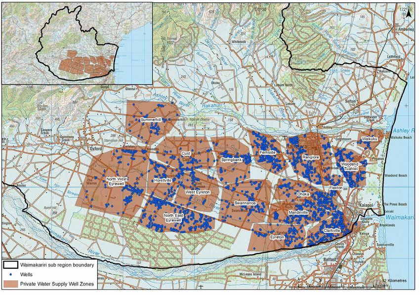
Waimakariri Zone Committee
  The Waimakariri Water Zone Committee is a joint committee of
  the Waimakariri District Council and Environment Canterbury.
  The Committee is made up of local residents –
  the members in 2018 are:
  David Ashby
  Grant Edge
  Carolyne Latham
  Gary Walton
  Judith Roper-Lindsay

                            T
  Cameron Henderson
  Michael Blackwell
  Cherie Williams – Ngāi Tūāhuriri Rūnanga representative
  Arapata Reuben – Ngāi Tūāhuriri Rūnanga representative
 AF
  Sandra Stewart – Councillor, Waimakariri District Council
  Claire McKay – Councillor, Environment Canterbury

  With support from:
  Technical support has been led by the strategy, planning and
  science sections of Environment Canterbury, with support
  from Waimakariri District Council staff l and specialist
  advisers
DR

 Mō tātou, ā, mō kā uri ā muri ake nei
   For us and our children after us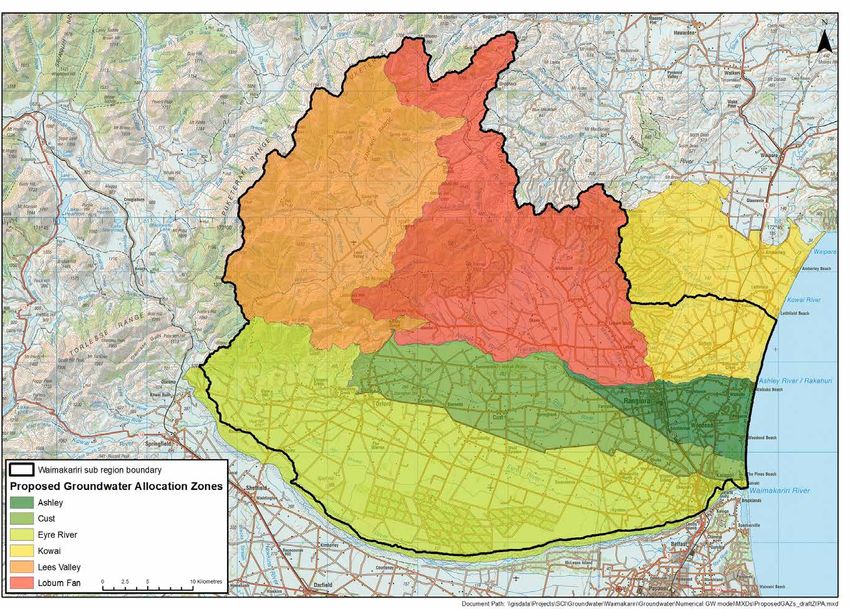
PROVIDING FEEDBACK

    THE ZONE COMMITTEE IS SEEKING YOUR FEEDBACK TO EXPAND OUR UNDERSTANDING
    OF FRESHWATER ISSUES AND HOW BEST TO ADDRESS THESE ISSUES.
    Please provide your feedback by visiting www.ecan.govt.nz/waimakariri-water
    or email waimakaririzone@ecan.govt.nz
    To provide direct feedback see us at one of the community workshops held
    in September and October 2018 or post your written feedback to:
    Meredith Macdonald,

                                                           T
    Environment Canterbury,
    PO Box 345, Christchurch 8140.

    FOR MORE INFORMATION VISIT: www.ecan.govt.nz/waimakariri-water
                      AF
DR

Waimakariri Draft Zone Implementation Programme Addendum                          1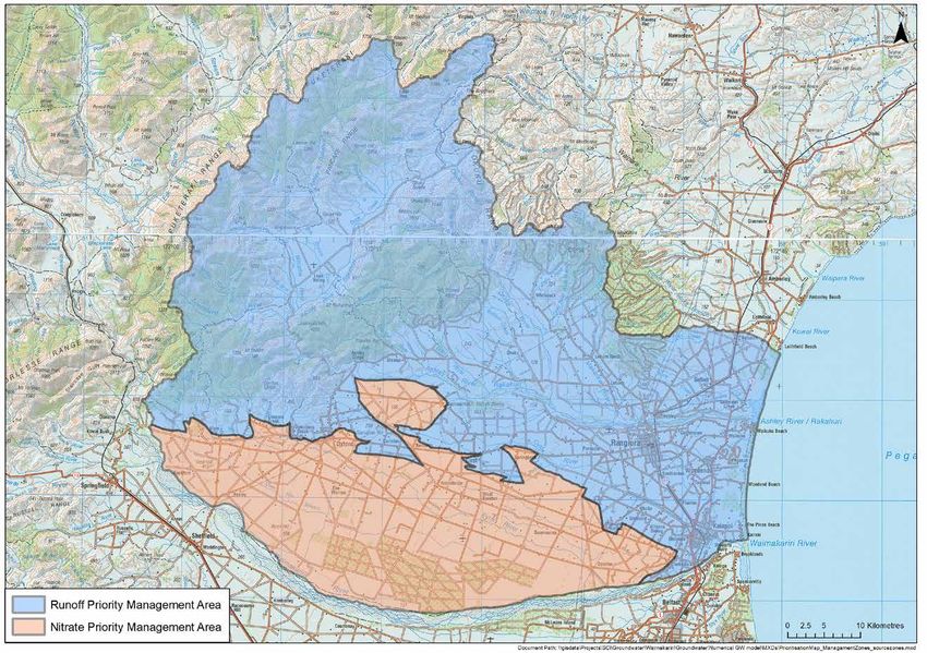
CONTENTS
PART A – INTRODUCTION
1. The Canterbury Water Management Strategy
2. Implementation of Recommendations
PART B – OVERVIEW OF THE WAIMAKARIRI WATER ZONE
1. Catchment and Community Profile – an overview
2. Ngāi Tūāhuriri Values
3. The Zone Committee’s Vision, Key Principles and Role
4. Community Outcomes
PART C – SOLUTIONS PROGRAMME
1. Scope of the Land and Water Solutions Programme
T
2. Current State and Future Pathways – Technical Overview
PART D – DRAFT RECOMMENDATIONS
1. Improving Stream Health
AF
2. Protecting and Enhancing Indigenous Biodiversity
3. Reducing Nitrates
4. Managing Surface Water – flows and allocations
5. Managing Groundwater – allocations
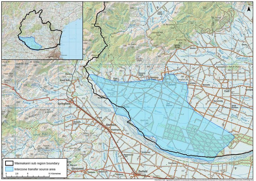
APPENDIX 1– MAPS
X1. Waimakariri Nutrient Allocation Zones
X2. Surface Water Allocation Zones – 1
X3. Surface Water Allocation Zones – 2
DR
X4. Groundwater Allocation Zones
X5. Private water supply well recharge areas
X6. Interzone Transfer Source Area
X7. Stream Recharge Zones
X8. Recommended Nitrate and Runoff Priority Management Areas
APPENDIX 2 – CANTERBURY REGIONAL BIODIVERSITY STRATEGY – SUMMARY
APPENDIX 3 – GLOSSARY
Waimakariri Draft Zone Implementation Programme Addendum 2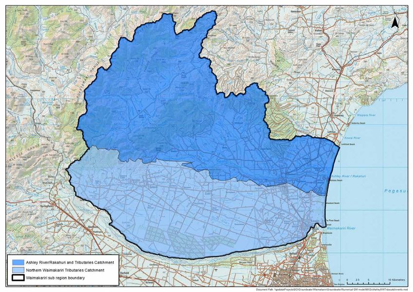
PART A – INTRODUCTION

    A1. THE CANTERBURY WATER MANAGEMENT STRATEGY (CWMS)
    The Canterbury Water Management Strategy (CWMS) was developed by the Canterbury Mayoral Forum in 2008 as a
    collaboration between Canterbury’s 10 territorial authorities and Environment Canterbury.
    The aim of the strategy is: “To enable present and future generations to gain the greatest social, economic, recreational
    and cultural benefits from our water resources within an environmentally sustainable framework.”

    Canterbury Water Management Strategy – Targets
    A set of 10 targets provides the strategy with a direction and balance, while ensuring all aspects are advanced in
    parallel. The strategy also establishes first and second order priorities , as below:
    • First order priorities: environment, customary use, community supplies and stock water.
    • Second order priorities: irrigation, renewable electricity generation, recreation and amenity

                                                             T
    Achieving continued economic production and environmental quality are also key to the strategy, as it is for the Resource
    Management Act (RMA) and the National Policy Statement for Freshwater Management 2017 (NPS-FM).
    The CWMS established 10 zone committees across Canterbury , largely defined by territorial authority boundaries. The
    zone committees implement the strategy through collaboration, assessment, and decision making. Each zone committee
    has developed a detailed ‘Zone Implementation Programme’ and works closely with their local community. Although
                       AF
    Zone Implementation Programmes are not statutory documents there is a very clear expectation and commitment for the
    programmes to be implemented, resourced, and given effect to through both regulation and on the ground actions.
    The Zone Implementation Programme ‘Addendum’ (ZIPA) builds on the original Zone Implementation Programme and
    provides recommendations to guide both the sub-region plan change to section 8 (Waimakariri) of the Canterbury Land
    and Water Regional Plan (LWRP), and actions to be advanced within the Waimakariri Water Zone and the Waimakariri
    District Plan. These recommendations, the sub-region plan change, and the programme of actions are collectively
    referred to as the Waimakariri Land and Water Solutions Programme.
    For more information on the CWMS go to:
    https://www.ecan.govt.nz/your-region/plans-strategies-and-bylaws/canterbury-water-management-strategy/

    The National Policy Statement for Freshwater Management
DR
    The NPS-FM sets out the direction for freshwater quality and quantity management in New Zealand. Regional councils
    must give effect to the requirements of the NPS-FM when developing statutory plans and plan changes. The NPS-FM
    requires freshwater quality to be maintained (where it is of good quality),or improved over time (where it does not meet
    the requirements of the NPS-FM), and includes a national objectives framework for achieving this. The NPS-FM also
    requires engagement with iwi, hapū, and the community in setting freshwater outcomes, and enables different methods
    and timeframes to be set. This document has provided the basis for the committee’s recommendations in terms of the
    freshwater outcomes and timeframes.
    For more information on the NPS-FM go to:
    http://www.mfe.govt.nz/fresh-water/national-policy-statement/about-nps

    A2. IMPLEMENTATION OF THE RECOMMENDATIONS
    The recommendations will be implemented through a sub-region plan change to section 8 of the LWRP, and importantly
    through practical actions in priority areas and catchments. The zone committee wants actions delivered in a coordinated
    way through non-statutory catchment management plans. The development of these plans and the practical actions that
    follow requires funding from a variety of sources.
    The LWRP sets out the planning framework for the management of land and water resources in Canterbury and is one
    method for implementing the CWMS.

Waimakariri Draft Zone Implementation Programme Addendum                                                                        3
Plan Change 5 (PC5) to the LWRP addresses water quality issues throughout the Canterbury region. When made operative
    it will introduce new definitions, policies, rules, limits and schedules which require farming activities to operate at “Good
    Management Practice”. PC5 provides both the foundation and starting point for managing nutrient losses from farming
    within the Waimakariri Water Zone.

    The Waimakariri River Regional Plan (WRRP) also has legal effect in part of the Waimakariri Water Zone, and manages
    water quantity, water quality and works in river and lake beds. Having two regional plans managing freshwater in the
    same zone adds unnecessary complexity for the regulator and plan user. This process provides an opportunity to create a
    simpler framework by incorporating the part of the WRRP that applies to the Waimakariri sub-region into section 8 of the
    LWRP.
    The Waimakariri District Council will also consider the zone committee’s recommendations when developing work
    programmes, budgets and reviewing their district plan.

    PART B. OVERVIEW OF THE WAIMAKARIRI WATER ZONE

                                                              T
    B1. CATCHMENT & COMMUNITY PROFILE – AN OVERVIEW
    The Waimakariri Water Zone (Maps B1 & B2) encompasses
    • The Ashley River/Rakahuri catchment and Ashley Estuary (Te Aka Aka);

    • The Loburn Fan;
                        AF
    • The catchments of the northern tributaries of the Waimakariri River;

    • The Ashley-Waimakariri Plain and associated groundwater zones (Ashley, Eyre, and Cust);
    • A network of spring-fed streams and lagoons near the coast and
    • Hill and high country in the north-western portion.
    Much of the land east of Rangiora, where the spring-fed streams are located, is reclaimed swamp which is still subject to
    poor drainage, occasional flooding and an extensive land drainage network.
    Waimakariri Water Zone
DR
    The Waimakariri Water Zone boundaries are similar to those of the Waimakariri District Council. The zone lies north of the
    Waimakariri River and extends from Pegasus Bay in the east to the Puketeraki Range in the west.
    Much of the land to the eastern part of the water zone is subject to poor drainage and occasional flooding. The rivers,
    streams, lagoons and wetlands have always been important places and a food basket for Ngāi Tūāhuriri. The water zone
    is part of the Rūnanga’s takiwā.

Waimakariri Draft Zone Implementation Programme Addendum                                                                            4
MAP B1. WAIMAKARIRI WATER ZONE BOUNDARIES

                                                           T
                      AF
DR

Waimakariri Draft Zone Implementation Programme Addendum       5
MAP B2. ASHLEY RIVER/RAKAHURI TRIBUTARIES AND
    NORTHERN WAIMAKARIRI TRIBUTARIES CATCHMENTS

                                                           T
                      AF
DR

Waimakariri Draft Zone Implementation Programme Addendum       6
Topography                                                      generally provides a higher level of protection. But transition
                                                                    to the LWRP method will mean that more groundwater
    The topography of the zone ranges from hills and                takes in the area covered by the WRRP will be classified as
    mountains, as high as 1800m, in the northwest to flat           stream depleting. These newly identified stream depleting
    coastal plains in the southeast. Alluvial sand and gravel       takes may see a reduction in reliability of supply as they will
    deposits dominate the plains with finer-grained estuarine       have a minimum flow imposed at times of low flow, whereas
    deposits along the coast. Light and very light soils are        previously the abstraction would have been unrestricted.
    found between the Eyre River and Waimakariri River. The
    Loburn Fan, areas along the Cust River and the coastal          Water Allocation
    plain are characterised by heavier soils. Hardpan soils
    which promote run-off to surface water are found to the         The Waimakariri Water Zone has been divided into Surface
    north of the Ashley River/Rakahuri, the Mairaki Downs and       Water Allocation Zones (SWAZs) which provide a water
    the hill-country near Oxford.                                   management regime using minimum flow and allocation
                                                                    limits. There are some SWAZs that are above, at or near
    Water Quality                                                   their allocation limit and several where the current
                                                                    minimum flow does not provide adequate protection for
    Surface water quality and aquatic ecosystems are                some aquatic species.
    generally degraded due to sediment and high nitrate
    concentrations (e.g. Silverstream at Island Road and            There are five Groundwater Allocation Zones (GAZ) –
    Harpers Road). However, many areas still support                Ashley, Cust, Eyre River, Loburn and Kowai. The Kowai GAZ
    important ecological values, particularly the upper             straddles the boundary with the Hurunui CWMS Water

                                                               T
    catchments of spring-fed streams like Silverstream and          Zone. Although groundwater allocation has increased
    Cust River / Cust Main Drain. Te Aka Aka is a sensitive         significantly in the last decade, allocated volume in the
    environment at the bottom of the Ashley River/Rakahuri          Ashley, Cust, Loburn and Kowai GAZs is currently under
    catchment and has high cultural, social and environmental       the allocation limit. The Eyre River GAZ is fully allocated.
    values. There has been historical habitat loss around           Approximately 70% of the allocated groundwater is used
                        AF
    the margins of the estuary and high concentrations of
    sediment and nitrogen promote macroalgae growth with
    potential for eutrophication.
    The Waimakariri – Ashley Plain is prone to extended dry
                                                                    for agriculture with 25% used for community water supply.
                                                                    Long-term groundwater trends are steady or increasing in
                                                                    some areas, likely due to leaking water races and irrigation
                                                                    on the plains and declining in others (e.g. the Ashley GAZ),
    periods with high evapotranspiration, especially during         probably due to drier climate conditions and increased
    north-westerly winds. Irrigation demand is high in the          groundwater abstraction.
    summer months when evapotranspiration is well above the         Groundwater quality is generally good and mostly meets
    average rainfall and there is a large soil moisture deficit.    drinking water standards without treatment. There are
    Flow in the rivers and streams fluctuates seasonally.           notable exceptions to this; with high nitrate concentrations
    Flow has also changed over the years with an increase           found in shallow private water supply wells near Cust, Ashley
    in base flow (no rainfall input) in some lowland streams        and Eyreton. Also, groundwater provides the transport
    since the start of the WIL scheme in 2000 and long-term         pathway for nitrate to spring-fed streams.
DR
    declines in the Ashley River/Rakahuri flow, probably due
    to drier climatic conditions. There is a complex pattern of     Biodiversity
    flow gain and loss across the plains east of the foothills
    in the Ashley River/Rakahuri and Cust River/Cust Main           Waimakariri District/Zone has diverse terrestrial and
    Drain. These water bodies, together with the Eyre River,        aquatic habitats supporting common and rarer plants and
    lose water to permeable alluvial gravels as they leave the      animals, including threatened species. The vegetation and
    foothills. These losses recharge the groundwater system         habitats are:
    and resurface as lowland stream flow.                           The upper Ashley River/Rakahuri, including Lees Valley,
                                                                    supports:
    Water Quantity
                                                                    • intact indigenous forest;
    Water allocation is currently governed by two regional
    plans; the LWRP and WRRP. One of the key differences            • remnant patches of beech and mixed podocarp forest;
    between these plans is the method for calculating the effects   • shrubland and grassland/herbfield vegetation;
    of pumping groundwater on nearby streams. The LWRP
    method quantifies the cumulative effect of abstraction on       • open rocky habitats at higher altitudes and in river gorges;
    river flow over an irrigation season (pumping an average        • springs and streams which are the source of the Ashley
    rate for 150 days and a maximum rate for 7 days) and is           River/Rakahuri;
    applied throughout most of Canterbury. The WRRP method
    estimates the effect of shallow groundwater takes if pumped     • springs and streams which are the source of some
    at an average rate over 30 days. The LWRP method is a more        northern Waimakariri tributaries;
    defensible calculation of the depletion effect on rivers and    • wetlands.

Waimakariri Draft Zone Implementation Programme Addendum                                                                              7
The dry plains (roughly west of State Highway 1) support: Dairy farming has been a feature of farming in the District
since the 1890s with a significant increase occurring
• three larger remnants of dry shrubland/grassland;
with the irrigation provided by the Waimakariri Irrigation
• scattered dry shrubland remnants on private property, Limited scheme.
including corners of paddocks, along fence lines and
While the community as a whole has an interest in the
associated with exotic vegetation (such as under
measures proposed in this draft ZIP Addendum, it is the
riparian willows).
people involved with the management of the farms who
• spring fed lowland streams with, in places, riparian will have to comply with the proposed changes and some
planting may find this challenging.
• the braided reaches of the Ashley River/Rakahuri
Recreation
The coastal plains (roughly east of State Highway 1) support:
There are many recreational opportunities in the Waimakariri
• coastal dune and wetlands remnants; in some places Water Zone including large areas of public land such as
(e.g. near Pegasus and Tūhaitara Coastal Park) Tūhaitara Coastal Park, Waimakariri and Ashley Regional
revegetation has actively increased indigenous plant Parks and Department of Conservation’s estate to the west
cover and indigenous fauna populations; of the zone. The Waimakariri District Council’s Ashley Gorge
and Silverstream Reserves, Northbrook Ponds and Kaiapoi
• spring fed lowland streams with, in places,
Lakes are also important recreation areas.
riparian planting
T
Ashley Gorge and the upper Okuku River are valued for
• Ashley Estuary (Te Aka Aka) - an extensive estuarine
white water kayaking. The Waimakariri and Kaiapoi rivers
area supporting many indigenous plants and animals.
and Pegasus Lake are used extensively for rowing, dragon-
Several nationally threatened plant and animal indigenous boating and mana-waka paddling. The Waimakariri Yacht
species are located within the zone, as well as many and Power Boat Club is based at Kairaki, and there are
locally rare species (that is, not common within the High opportunities for small boat sailing on Pegasus Lake.
AF
or Low Plains Ecological Districts).
The rivers, streams, lagoons and the wetlands of the
Waimakariri have always been an important place and
food basket for Ngāi Tahu and Ngāi Tūāhuriri.
Fishing is another significant activity from the Waimakariri
River to the Ashley River/Rakahuri. The Kaiapoi River is
another important waterway for whitebait, trout and
salmon fishing, with some salmon raised at the Silverstream
The Ashley River/Rakahuri and Saltwater Creek hatchery finding their way back into the Kaiapoi River.
Estuarine areas are recognised by the International
Union for Conservation of Nature (IUCN) as a wetland of
Economy
“international significance”. The largest sectors in the Waimakariri Water Zone
economy are construction and retail trade, and these are
Social proportionately larger than both the Canterbury and national
The current estimated population for the Waimakariri averages. Agriculture is also an important part of the
DR
District is 59,300. Approximately 77% of the District’s economy (top 5) and is similarly overrepresented in the zone.
population lives in the south-east, south of the Ashley Growth has been strong since the Canterbury earthquake
River/Rakahuri and east of Two Chain Road area. The sequence – driven by construction and population growth.
Oxford township provides the focal point for social activity
for the rural community to the south-west and west
Land use
of the District. There are smaller social “hubs”, often Approximately 103,490 ha (40% of the land area) is used
based around schools and sports facilities, throughout to farm sheep, deer, and beef. Dairy and dairy support
the District that provide the basis for maintenance of account for 38,000 ha (16% of land area). There are also
community cohesion at a local level. many small block holdings (lifestyle blocks) encompassing
approximately 29,000 ha (12% of land area). In total,
The age distribution for the District differs significantly from
there are approximately 37,000 ha of irrigated land in
that of Canterbury, with few younger adults living in the area,
the Waimakariri zone with three irrigation schemes:
and a higher percentage of residents aged 40 years and
Waimakariri Irrigation Limited (WIL), Loburn Irrigation
over. There has been a slight increase in percentage of non-
Company and the Moy Flat scheme.
European children (from 11% in 2000 to 19% in 2017).
There has been a strong increase in local employment
between 2000 and 2017 with a proportionally lower
increase in agricultural employment. Approximately 40%
of the workforce travels to Christchurch to work.
Waimakariri Draft Zone Implementation Programme Addendum 8B2. NGĀI TŪĀHURIRI VALUES
Mihi
Ko o matou whakaaro ki te whenua Our thoughts are to the land
Nga roto, nga awa, te moana To the lakes, the rivers and the sea
Hei here I a tātou That bind us together
O nga tupu tupunga To preserve well-being of the vines
o Te Aka O Tu Whenua Of Tu Whena (land and water)
Hei whakato whakatipu That gave rise to
I nga mahinga kai a te Iwi The people’s food gathering places
Ko matou Tūmanako Our hopes are that
Te tatau o te Mātauranga The doors of knowledge
o nga whakaaro And the doors thought
T
Hei here ai a Iwi, That have held our people
a mana and our authority captive
Kawhakapuakina Will be opened
Kia marino ai te wai
O te whakaaro kotahi
Kia tau ki uta
AF That the waters of these thoughts
Be calmed and settled as one thought
That this canoe of hope
Tēnei waka tūmanako That this canoe of love
Tēnei waka aroha May reach shore safely
Kia tau te rangimarie And that peace may prevail amongst us
Tēnei te tangi This is the call
DR
O nga whakatupuranga Of the rising generations
O Ngāi Tahu Whānui Of Ngāi Tahu people
Kia koutou, nga tangata To you, the people
O nga marae maha Of the many marae
Kia ora tātou e tu nei Greetings to you all
Ngāi Tūāhuriri contend that the Crown’s right to govern, fisheries, and mahinga kai-food and other resources, Ngāi
as gifted in Article the First, is totally dependent on the Tūāhuriri maintain that these taonga still belong to them.
honouring of Article the Second. That is, the recognition
This Ngāi Tūāhuriri position has been reinforced by Te
and protection of the Tribe’s resource ownership authority
Runanga o Ngai Tahu who have taken it to be the Ngai Tahu
rights, including the rights to use and have access to those
position on Freshwater, that position is;
resources.
• Ngāi Tahu have rights, interests, obligations and
Ngāi Tūāhuriri maintain that they did not alienate their
responsibilities in the flow and quality of water in our
resources or taonga by signing the Treaty of Waitangi. As the
takiwā.
Crown had not acquired the ownership of the Tribe’s water,
Waimakariri Draft Zone Implementation Programme Addendum 9• Ngāi Tahu has ownership over freshwater and will Kaitiakitanga is integrated into each pathway with actions to
continue to exercise tino rangatiratanga in our takiwā. address water quality and quantity concerns and provisions
for improved customary use and the involvement of Rūnanga
• Ngāi Tahu shall accept a Governing Body which reflects
in water management weaved through this document.
the Treaty Partnership.
The pathways and recommendations in this ZIP Addendum
• That Governing Body shall lead policy and regulatory
represent an integrated approach to water management and
development to achieve Freshwater aspirations.
should not be considered in isolation. The zone committee
• Freshwater royalties or taxes (or similar) shall be recognises the need for an integrated approach to water
used to meet that Governing Body’s obligations, quality, quantity, and land management.
responsibilities and aspirations in Freshwater.
The collaborative approach used in the development of
The Waimakariri Zone Committee acknowledges that the the Canterbury Water Management Strategy and by the
rights and interests of iwi have not been resolved and that zone committee in developing this Solutions Programme
this creates considerable uncertainty in New Zealand’s must be carried through to the implementation of
freshwater management system. The Waimakariri Zone the recommendations.
Committee is of a view that leaving iwi rights and interests
unresolved will create considerable risks to the long-term The Role of the Waimakariri Water
durability of any freshwater management framework. Zone Committee
The Waimakariri Zone Committee urges the Crown to The Waimakariri Water Zone Committee was formed in
T
prioritise work with iwi to reach agreement on how to resolve 2010 as a joint committee of Waimakariri District Council
the rights and interests of iwi in freshwater. and Environment Canterbury. The zone committee has
representatives from the two councils, Ngāi Tūāhuriri
Recommendation: Rūnanga, and the wider community.
That Environment Canterbury and the Waimakariri District The zone committee’s role is to develop and facilitate
AF
Council, along with Local Government NZ, work together
with Ngāi Tūāhuriri and Ngāi Tahu to lobby central
government (the Crown) to prioritise the resolution of iwi
rights and interests in freshwater.
Note: The zone committee did not reach consensus on this
enduring water management solutions that give effect
to the Canterbury Water Management Strategy’s vision,
principles and targets. The zone committee’s initial priority
was to complete the Waimakariri Zone Implementation
Programme (ZIP), which it completed in 2012. This draft ZIP
Addendum (2018) builds upon the original ZIP, including the
recommendation. While there was general support for the
community outcomes, which provide a sustained focus for
above recommendation, an alternate view queried if this was
the Waimakariri Water Zone and community.
part of the zone committee’s scope for this ZIP Addendum.
The zone committee’s role is to facilitate community-based
solutions, while balancing cultural, economic, environmental
B3. ZONE COMMITTEE VISION, & social values for the water zone. The zone committee, like
PRINCIPLES AND ROLE the Canterbury Water Management Strategy, is focused on
DR
collaboration and seeks to reach decisions by consensus.
In developing these draft recommendations, the zone
Zone Committee Vision committee hasn’t always reached consensus. Where a
Mō tātou, ā, mō kā uri ā muri ake nei divergence of views occurred, it has been noted.
For us and our children after us
What Does Success Look Like?
The Waimakariri Water Zone Committee has had this Ngāi
Tahu whakatoki as an expression of commitment since it was The zone committee’s measure of success is based on
formed in 2010. Along with Ngāi Tūāhuriri Rūnanga, and many improvements measured against Canterbury Water
others in our community, the zone committee is committed Management Strategy targets, while achieving the
to achieving improved water management outcomes for the community outcomes of this Zone Implementation
Waimakariri Water Zone within a generation. Programme Addendum (see section B5).
The zone committee appreciates time will be an important
Zone Committee Principles factor in achieving these targets and outcomes. The initial
A ‘whole of waterway’ approach is taken to integrate steps need to focus on halting declining trends in water
management from the mountains to the sea – Ki Uta Ki Tai. quality where they have been identified in the water zone .
The zone committee wish to see activities integrated across The zone committee is committed to what can be achieved
agencies and groups working together using an outcome- in a generation and the following graphic illustrates
based approach. what success can look like, relative to the targets of the
Canterbury Water Management Strategy.
Waimakariri Draft Zone Implementation Programme Addendum 10WHAT SUCCESS LOOKS LIKE
From the mountains to the sea - Ki uta ki tai
Biodiversity
corridors
established
Thriving and
prosperous
Natural river
communities
flow maintained
All communities and
marae have access to high
quality drinking water
Braided rivers
protected
Water storage
implemented
T
Nutrient management
plans used
Coastal
biodiversity Flows restored
enhanced to lowland
AF
More groundwater for
environmental and
cultural use
Efficient on-farm
water use
Mahinga
kai values
protected
Water quality
standards are met
spring-fed
streams
Figure B.1 The Canterbury Water Management Strategy – What Success Looks Like
A collaborative Canterbury process
He puna wai, he puna tangata
The pool of water sustains the pool of people
B4. WAIMAKARIRI WATER ZONE – Outcome 2 – The Ashley River/Rakahuri is safe for
contact recreation, has improved river habitat, fish
COMMUNITY OUTCOMES passage, and customary use; and has flows that
DR
These community outcomes were affirmed by the zone support natural coastal processes
committee, based community feedback gathered from a Narrative: The river meets national standards for
series of community meetings held in 2014/15 and 2016. swimmable contact recreation. The habitat and fish
They provide a primary focus for this Solutions Programme passage along the river are improved to encourage more
and align with the original priority outcomes of the customary use and mahinga kai gathering. Braided river
Zone Implementation Programme developed with the bird populations are protected, and numbers improved.
community in 2011. The river mouth and estuary are healthy and functioning.
The narratives for each outcome represent the zone
Outcome 3 – The Waimakariri River as a receiving
committee’s vision and ‘measures of success’.
environment is a healthy habitat for freshwater and
Outcome 1 – The water quality and quantity of spring- coastal species, and is protected and managed as an
fed streams maintains or improves mahinga kai outstanding natural landscape and recreation resource
gathering and diverse aquatic life Narrative: Flow and water quality are maintained to
Narrative: The habitat, flow and water quality in the spring support and enhance aquatic life. The river mouth
fed streams supports abundant and diverse aquatic life is healthy and functioning. The natural braided
(including native flora and fauna). Spring fed streams characteristics of this alpine river are recognised for
contain safe and plentiful kai for gathering. The flow aesthetic and amenity values. Recreational opportunities,
and visual appearance of the spring fed streams meet along and on the river, are sustained.
aesthetic values and promotes customary use. Plant and
animal pest species are managed or eliminated.
Waimakariri Draft Zone Implementation Programme Addendum 11Outcome 4 – The zone has safe and reliable drinking Management Practices and Farm Environment Plans are
water, preferably from secure sources adopted as everyday farm management tools.
Narrative: Community drinking and domestic supplies
Outcome 8 – There is improved contribution to the
meet New Zealand drinking water standards .
regional economy from the zone
Outcome 5 – Indigenous biodiversity in the zone is Narrative: The zone has thriving, and vibrant communities
protected and improved supported by a sustainable local economy based on
diverse and productive land and water use. Integrated
Narrative: Protect and improve the indigenous biodiversity,
and sustainable management of the effects of flooding,
habitat or ecosystems. Plant and animal pest species are
earthquakes and climate change protects assets and
managed or eliminated.
amenities and builds resilience in communities and
ecosystems.
Outcome 6 – Highly reliable irrigation water, to a
target of 95%, is available in the zone Interzone Groundwater Outcome
Narrative: Irrigation water (from both surface and
groundwater) reliably supplies water to meet demand Outcome 9 – Land and freshwater management in the
when operating within flow and allocation regimes. 100% Waimakariri Water Zone will, over time, support the
of the irrigated area can be irrigated 95% of the time. The maintenance of current high-quality drinking water
effects of climate change are considered in the planning from Christchurch’s aquifers
T
and effective long-term management of water and land.
In response to the initial findings of the technical
Opportunities for water storage are considered.
investigations of the groundwater movement between the
Waimakariri and Christchurch West Melton water zones,
Outcome 7 – Optimal water and nutrient management
this outcome was also agreed by the zone committee in
is common practice
2018 as part of development of the Waimakariri Land and
AF
Narrative: All land and water users’ practise management
that maximises water use efficiency and minimises inputs
of nutrients and pollutants to water. Industry agreed Good
Water Solutions programme.
PART C. LAND AND WATER SOLUTIONS PROGRAMME
C1. WHAT IS THE WAIMAKARIRI LAND AND WATER SOLUTIONS PROGRAMME?
DR
The Waimakariri Land and Water Solutions Programme is a first step in setting a direction for water management in the
Waimakariri Water Zone. This solutions programme:
• Provides focus and direction for achieving community outcomes for water management in the Waimakariri Water Zone
for the next 50 years.
• Sets out a staged approach to achieving community outcomes for water management on a 10 – 20 – 50-year timeframe
with regular 10 years reviews to incorporate new information and lessons learned.
• Establishes a monitoring framework to review progress as part of this staged approach.
• Provides recommendations to inform the planning provisions of the Waimakariri chapter of the Canterbury Land and
Water Regional Plan.
• Provides a programme of actions to 2030.
Waimakariri Draft Zone Implementation Programme Addendum 12Waimakariri
Land & Solutions Programme
Zone Committee water management recommendation timeline Planning
Process
Oct 2016 – Feb 2017 Mar 2017 – Aug 2018 Sep 2018 Oct/Nov 2018 Nov 2018 Dec 2018 Mid 2019
WAIMAKARIRI
2016 2017 2017 2018 2018 2018 2018 2019
Review community feedback LWRP Plan notification
Test options with community
on draft recommendations
On the ground actions
Explore current state Ask for feedback on
& other scenarios DRAFT recommendations
Waimakariri Draft Zone Implementation Programme Addendum
Finalise recommendations
DR LAND & SOLUTIONS PROGRAMME
Figure 3.1 – Waimakariri Solutions Programme Timeline
AF
T
13C2. CURRENT STATE AND FUTURE Social / Recreational / Economic
PATHWAYS – TECHNICAL OVERVIEW • The zone has a unique mix of land uses
• Water supplies for agriculture (irrigation and
Current State Assessment – overview stockwater) are important for the local economy
Environment Canterbury undertook a technical • There are close links between Waimakariri and
assessment programme from 2015 to 2017 to better Christchurch City
understand key biophysical elements (water quality, water
Environmental
quantity, biodiversity and instream ecosystems) and their
corresponding influence on cultural, social, recreational • Changes in land cover since human settlement
and economic values within the Waimakariri Water Zone.
• Some areas could be described as water short, normally
These ‘current state’ assessments focussed on taking a
‘snapshot’ of these key elements and associated values. • Vulnerable to drought, particularly multi-year dry periods
The assessments also looked for any historical trends. • Most wetlands have been drained
As part of the current state assessment two scenarios,
• Ashley Estuary (Te Aka Aka) is a significant and sensitive
‘current pathways’ and ‘alternative pathways’ were also
environment at the bottom of the catchment
assessed. The ‘current pathways’ scenario considered
likely outcomes assuming no changes to current land-use. • High sediment loads in many streams and rivers
The alternative pathways scenario looked at how changing
T
• Nitrogen concentrations are high in some streams
land-use management may impact on environmental,
cultural, social, recreational and economic outcomes. • Drinking water quality is generally good, but nitrate
Understanding these interactions has informed the concentrations are elevated in some wells
Waimakariri land and water solutions programme’s • Flows in the Ashley River/Rakahuri have declined over
development and supported the zone committee to the last few decades. Water levels in wells and flows in
AF
develop the draft ZIP Addendum recommendations.
Current State Assessment – Reports
In 2016 and 2017 Environment Canterbury produced technical
spring-fed streams near the Ashley River/Rakahuri have
also declined.
• Groundwater levels in Silverstream area and flows in
Silverstream are declining
assessments for the Waimakariri Water Zone on the following:
• Groundwater recharge from Waimakariri Irrigation
• Groundwater quality and quantity
Limited and stockwater race network water losses
• Water quality and ecology and inefficient irrigation have offset a large increase in
• Hydrology groundwater abstraction
• Biodiversity Current Pathways Scenario Assessments –
Key Findings
DR
• Cultural health and water management
• Ashley Estuary (Te Aka Aka) ecology and water quality The second stage of the Current State assessment was
to explore scenarios based on what might happen if the
• Socio-economic profile current state (2016/17) was projected into the future,
• Recreation assuming current land management rules and practices
are unchanged. This scenario has been referred to as the
• Economic Current Pathways scenario. Key findings included:
To view these reports and more information on the current Ngāi Tūāhuriri values
state assessment for the Waimakariri Water Zone, go to:
www.waimakariri-water.nz • Many streams and rivers will fail to sustain Ngāi
Tūāhuriri values
Current state key findings Ecology – stream health
The key findings of the current state technical reports are
• Sea level rise resulting in saltwater intrusion in lowland
provided below and discussed in detail in the rest of this
tidal waterways, coastal retreat and loss of coastal habitat
overview.
• Continued overland flow of contaminants (phosphorus,
Ngāi Tūāhuriri values
sediment and E. coli)
• Many streams and rivers no longer sustain mana
• Increase in stormwater contaminants
whenua values
• Continued habitat loss in freshwater and coastal
• Mana whenua are particularly concerned about Cam
waterbodies
River/Ruataniwha, Ashley River/Rakahuri, Little Ashley
Creek, and Taranaki Creek
Waimakariri Draft Zone Implementation Programme Addendum 14Biodiversity in groundwater abstraction, depending on rainfall
• Continued decline in extent of high biodiversity value • Further flow decreases in the Ashley River/Rakahuri,
habitats, especially for indigenous forest, broadleaved increasing length and duration of dry reaches in the
indigenous hardwood scrub, kanuka and herbaceous river and causing reduced flows in the spring-fed
freshwater wetland vegetation. streams sustained by losses from the river
• Projected increase of low biodiversity value habitats such • Less snowfall (affects flows in alpine rivers such as the
as high producing grassland, orchards and urban areas. Waimakariri River)
Nitrates • The potential for less winter rainfall with more rainfall in
• A groundwater model was used to evaluate the summer and autumn.
possible range of future nitrate concentrations in water Economic assessment
supply wells and surface water bodies. The model
was developed collaboratively between Environment • Population is expected to increase from current
Canterbury staff and a panel of external experts and (59,300) to an estimated 97,000 in 2048
was reviewed by expert panel members on completion. • Small increase in agricultural productivity associated
A thorough analysis of the uncertainty around modelled with growth in irrigated area, but overall economic
nitrate projections was undertaken, in recognition of gain is offset by removal of productive land into lower
the fact that modelled estimates of future water quality producing small-block holdings, and to a lesser extent
T
outcomes are uncertain. by the impacts of lower reliability and costs associated
• Current Pathways modelling results have highlighted with achieving clean drinking water.
the potential for significant nitrate concentration
increases in surface water and groundwater in
some areas within the Waimakariri Water Zone (e.g.
C3. PROGRAMME EVALUATION AND
MONITORING
AF
Silverstream and some deep-water supply wells)
because of the time it takes for groundwater to travel
from the source area (i.e. nitrates already “in the post”)
• Groundwater modelling and other investigations
The Waimakariri Water Zone Committee is committed to
evaluating progress made in implementing the Land and
Water Solutions Programme. Various recommendations in
undertaken in 2016-2017 concluded that groundwater
this document focus on monitoring and building collective
in the Waimakariri Water Zone is likely to flow under
knowledge of the issues, and possible solutions, to improving
the Waimakariri River and into the Christchurch aquifer
water management in the Waimakariri Water Zone.
system. The Waimakariri Water Zone Committee has
made recommendations for nutrient management in The Water Zone Committee will also develop a 5-year
their zone, to “play their part” in maintaining the high work programme to oversee and evaluate progress in
quality of water in the Christchurch aquifers. implementing these recommendations. To align with
the Land and Water Solutions Programme over the next
DR
• Permitted activity rules in Plan Change 5 of the LWRP
decade the following approach is proposed:
could offset any nitrate reduction gains from Good
Management Practice (GMP) and cause significant 2019-2021 Solutions Programme – Establishment stage
increases in nitrogen discharges to some sensitive
This will include:
water bodies e.g. Ashley Estuary (Te Aka Aka).
• Initial catchment management plans underway
Stream flows
• Identified actions which can be implemented
• Reduction in flows, especially Silverstream, Ohoka
immediately underway
Stream and Cust Main Drain due to improved irrigation
efficiency and increased groundwater abstraction within • Engagement and, where possible, establishment of
current allocation limits Water User Groups
Groundwater quantity • Funding plan for implementation of the programme
prepared.
• Decrease in water supply well reliability and spring-fed
stream flows due to potential increases in groundwater 2021-2025 Solutions Programme – 5-year priorities stage 1
abstraction and improved irrigation efficiency
• A set of priorities to be achieved by 2025 will be prepared
Possible climate change effects and monitored over a five-year period, to 2025.
• Increase in the frequency, duration and severity of 2026-2030 Solutions Programme – 5-year priorities stage 2
droughts causing increased stress on water resources
• Based on a review of progress made to 2025, a revised
and impacts on stream health
set of priorities will be prepared to direct progress over
• An increase in evapotranspiration with associated increase the following 5 years, to 2030.
Waimakariri Draft Zone Implementation Programme Addendum 15PART D. DRAFT RECOMMENDATIONS
KEY RECOMMENDATION AREAS – DRIVERS OF CHANGE
The following key recommendation areas provide the structure for the solutions programme ZIP Addendum. They are the
drivers of change required to achieve community outcomes and address water management issues for the Waimakariri
Water Zone.
The zone committee developed the following key recommendation areas in response to issues identified by the current
state and future pathways assessments, and overarching community outcomes. This solutions programme is focused on:
1. Improving Stream Health
2. Protecting and Enhancing Indigenous Biodiversity
3. Reducing Nitrates
4. Managing Surface Water Quantity
5. Managing Groundwater Quantity
T
D1. RECOMMENDATIONS – IMPROVING Catchment Management Plans
STREAM HEALTH The zone committee views non-statutory catchment
management plans as a critical tool to assist in delivering
D1.1 Key Issues
AF
The key issues for improving stream health within the zone
are:
outcomes on the ground and taking a holistic view
of management. The committee will prioritise two
catchments to be addressed in the first year following
ratification of the ZIPA, and develop plans with support
from Environment Canterbury, landowners, Ngāi Tūāhuriri
• There is a need for adequate habitat protection for Rūnanga, Waimakariri District Council, farming industry
waterways and riparian habitats that contribute to and other organisations. Plans will build on existing
stream health. initiatives to set out visions for the waterways and identify
• There is a need for improved data on ecological health new actions, lead partners, and funding.
in waterways, the influence of specific land uses, and Supporting Good Management Practice
an improved monitoring regime to set priorities and
management targets. PC5 to the LWRP introduces Good Management Practices
DR
(GMP) on-farm into the planning framework through
• The lowland /plains reaches of waterways in the zone policies, rules and targets in Farm Environment Plans
are generally in poor ecological health due to a variety for consented farming activities. It also introduces
of factors. management plans and targets for farms that do not
• Poor ecological health results in low cultural and need resource consent. The zone committee sees
recreational values. Farm Environment Plans and Management Plans as
the cornerstone for managing contaminant losses to
• The ecological health of hill country waterways needs to
waterways and for improving biodiversity, stream ecology
be protected from adverse effects of natural and induced
and mahinga kai through education and support to
bank erosion, and potential effects of forestry operations.
farmers and landowners.
• There is a need to protect and establish healthy There are over 3,500 smaller lifestyle properties in the
populations and habitats of indigenous plant and zone, most of which are classified as permitted activities in
animal species across the zone. the Land and Water Regional Plan because of their small
size. Collectively these properties can have a cumulative
D1.2 Rationale impact on water quality and stream health if not managed
The zone committee proposes a wide range of tools well. The zone committee wants to extend a pilot education
for protecting and improving stream water quality and programme targeted at small block holders and promote the
ecological health. These include practical actions, planning development of Lifestyle Block Management Plans.
mechanisms, education and support, engagement with
Improving environmental monitoring
industry bodies and extra monitoring effort. Nitrates and
stream flows are clearly relevant to stream health and are State of the environment (SOE) monitoring is key to
addressed separately in later sections of this document. understanding the state and trends of water quality and
Waimakariri Draft Zone Implementation Programme Addendum 16ecosystem health in the Waimakariri Water Zone. A successful Regional Plan. The zone committee wishes its braided river
monitoring programme will include the establishment of a values to be protected.
robust and representative network of monitoring sites across
The braided nature of the Ashley River/Rakahuri channel
a variety of catchment types and areas.
becomes constrained by terrestrial weed (e.g. gorse,
Protecting aquatic biodiversity willows, and broom) growth in the mid-catchment and
requires extensive weed control to protect its braided river
The Waimakariri Water Zone contains numerous aquatic character and bird nesting habitat. The effects of forestry
species of high ecological, cultural and recreational practices in the upper hill-fed catchments of the Okuku and
value. However, many years of land use development Makerikeri Rivers has caused concern amongst community
has resulted in many species or populations becoming members, however, limited monitoring makes determining
lost or threatened. At risk species include the threatened the real effects of such practices downstream difficult.
Canterbury mudfish, lamprey, freshwater mussels, longfin
eel and kōura. A key factor contributing to the loss of Spring-fed tributaries of the lower Ashley River/Rakahuri
these species has been habitat loss or degradation. catchment are highly valued by both Ngāi Tūāhuriri and
local community. The degradation of these streams is
Stream surveys and investigations have identified typical of that displayed by most spring-fed waterways
numerous barriers to migratory fish passage throughout in the Waimakariri Water Zone with excessive deposited
the zone. These include flood and tide gates, weirs, and sediment and poor habitat quality. Water quality in these
culverts. The remediation of such barriers is important streams has flow-on effects to downstream aquatic
to ensuring that the recruitment of individuals into the environments, especially the Ashley Estuary (Te Aka Aka).
T
middle and upper reaches of catchments is allowed.
Northern Waimakariri Tributaries area
Protecting natural waterbody character and
Many issues in the Waimakariri Water Zone are centred
ecosystem function
around the spring-fed tributaries that flow into the Kaiapoi
Many waterways in the Waimakariri Water Zone have River and eventually the main stem of the Waimakariri
AF
been extensively modified. Spring-fed plains streams
have been affected by stream realignments, channel
straightening, bank modifications and more. Protecting the
natural character of streams can have multiple long-term
aesthetic and ecosystem benefits.
River. Unlike other catchments in the zone, the Cam River/
Ruataniwha and Kaiapoi River flow through substantial
urban populations. For this reason, these waterways
receive stormwater inputs that can greatly affect instream
water quality. One significant change was the Rangiora
sewer ponds ceasing to discharge into the Southbrook,
Coastal waterbodies
and thus into the Cam River/Ruataniwha, in 2006.
Coastal waterbodies are highly valued ecosystems. They
Streams in the Northern Waimakariri Tributaries area are
are culturally important and serve as nursery, feeding
highly valued for their amenity and recreation values, and
and resting grounds for a variety of migratory fish species
there is significant scope to rehabilitate degraded reaches
and birds. Located at the bottom of river catchments, of streams. This work has already begun in places such as
they act as basins which capture upstream contaminant the Cam River/Ruataniwha catchment. A growing urban
DR
inputs. The Ashley Estuary (Te Aka Aka) and tidal reaches population, community education and environmental
of spring-fed plains streams have been particularly awareness programmes will also create positive changes
affected by habitat degradation associated with excessive in these streams.
sediment deposition. Managing upstream contaminant
losses to protect coastal waterbodies downstream is a Aligned with Community Outcomes
critical component of any good catchment management • The water quality and quantity of spring-fed streams
plan. Developing a robust monitoring programme for maintains or improves mahinga kai gathering and
tidal-freshwater and estuarine waterbodies will improve diverse aquatic life
the current poor understanding of ecosystem state and
trends. The extent and characteristics of tidally influenced • The Ashley River/Rakahuri is safe for contact recreation,
waterbodies are expected to shift with climate change and has improved river habitat, fish passage, and customary
rising sea levels. use; and has flows that support natural coastal processes
• The Waimakariri River as a receiving environment is a
Ashley River/Rakahuri and Saltwater Creek catchment healthy habitat for freshwater and coastal species, and
The zone committee identifies the Ashley River/Rakahuri is protected and managed as an outstanding natural
as an important natural landscape feature. As such, landscape and recreation resource
the committee believes it should be safeguarded in its • Indigenous biodiversity in the zone is protected
upper-catchment above the gorge, which is an area that and improved
has undergone less land use intensification relative to
• Optimal water and nutrient management is
downstream. The Ashley River/Rakahuri (and to a lesser
common practice
extent the Okuku River) affords many characteristics of an
alpine braided river, as defined under the Land and Water
Waimakariri Draft Zone Implementation Programme Addendum 17D1.4 Draft Recommendations – –– Ohoka Stream
Improving stream health –– Cust River and Cust Main Drain
Cross-outcome recommendations –– Taranaki Creek, Waikuku Stream, and Little
Rec 1.1 Ashley Creek
That Environment Canterbury and the Waimakariri District –– Ashley River/Rakahuri Gorge
Council support the Waimakariri Water Zone Committee to –– Saltwater Creek
prioritise catchments and develop at least two Catchment
Management Plans per year. These plans will provide b. State of the Takiwā monitoring, including the health and
specific catchment management actions, monitoring, wellbeing of mahinga kai species including:
and prioritising to support the implementation of ZIP –– Tuna (freshwater eels)
Addendum recommendations.
–– Īnanga (whitebait species)
Rec 1.2
–– Kākahi (freshwater mussels)
That Environment Canterbury and the Waimakariri Water
Zone Committee support industry groups to provide sector, –– Kanakana (lamprey)
and catchment-specific support to landowners implementing –– Kōura (freshwater crayfish)
Good Management Practice (GMP), including:
–– Tuangi (cockles)
T
a. sub-catchment groups working to reduce
contaminant losses. –– Pātiki (flounder)
b. increasing education and awareness of the Farm c. Measuring diversity and distributions of freshwater fish,
Environment Plan audit and accreditation process invertebrates and aquatic vegetation throughout the zone.
amongst wider community. d. Identifying critical sources areas and measuring
AF
c. educating and supporting landowners to protect
catchment-specific ecological, biodiversity and Ngāi
Tūāhuriri values by:
–– Preparing catchment management plans to
deposited sediment extent and character, particularly in
spring-fed plains streams (Cam and Kaiapoi rivers) and
the Ashley River/Rakahuri – Saltwater Creek Estuary.
e. Including important bathing sites in Schedule 6 of the
implement on-the-ground waterway remediation Land and Water Regional Plan and assess primary
projects at sites identified as priorities. recreational water quality at:
–– As part of the Land and Water Regional Plan – Plan • Ashley River/Rakahuri at Gorge
Change 5, Farm Environment Plans and Management • Ashley River/Rakahuri at Rangiora-Loburn Bridge
Plans identify any areas of significant indigenous
biodiversity, as identified by District Council or • Ashley River/Rakahuri at State Highway 1
Department of Conservation, and methods of • Kaiapoi River at Kaiapoi township
DR
complying with any District Plan rules.
f. Continue information sharing and integrate monitoring
–– Providing workshops in vulnerable hotspots programmes between organisations, and promote
(i.e. high value or high contaminant loss) areas. community-based monitoring of waterways (citizen
Rec 1.3 science) and education initiatives
That Environment Canterbury promotes the use of Lifestyle g. Investigate the ecosystem health of hill country
Block Management Plans and provides workshops to waterways to identify issues and catchment-specific
engage with small block owners to educate and incentivise management options as required.
them to minimise contaminant losses and enhance
h. Support ongoing research into emerging contaminants,
waterways on their properties.
including endocrine disruptors, in the Waimakariri
Monitoring and Research Water Zone.
Rec 1.4 i. Investigate tidal waterbodies related to:
That Environment Canterbury implement a comprehensive a. Sediment deposition and salt water intrusion in:
waterway monitoring plan for the Waimakariri Water
• Ashley River/Rakahuri – Saltwater Creek Estuary
Zone, including:
• Tidal reaches of Kaiapoi River, Saltwater Creek and
a. Monitoring sites for water quality and ecological health
Taranaki Creek
of waterways:
b. Aquatic habitat shifts associated with climate
–– Kaiapoi River and Silverstream sub catchments
change and sea level rise, including changes in
–– Cam River/Ruataniwha and tributaries īnanga spawning areas.
Waimakariri Draft Zone Implementation Programme Addendum 18Rec 1.5 Rec 1.11
That Environment Canterbury and Waimakariri District That Environment Canterbury work with Ngāi Tūāhuriri to
Council investigate the impact of wilding pines on identify the locations and types of activities and controls
downstream freshwater ecosystems by monitoring streams needed to protect the habitat of important indigenous
and rivers with wilding pines in their catchments. species including:
Rec 1.6 • Freshwater crayfish/kōura
That Environment Canterbury and Waimakariri District • Freshwater mussels/kākahi
Council investigate the impact of commercial forestry
• Lamprey/kanakana
practices on downstream freshwater ecosystems by
monitoring streams and rivers with production forestry in Protecting and enhancing aquatic ecosystem health
their catchments.
Rec 1.12
Rec 1.7
That Environment Canterbury resource and support
That Environment Canterbury and the Waimakariri District catchment management plans implementing on the
Council support further research into factors that influence ground projects targeted at rehabilitating the freshwater
and/or control toxic cyanobacteria growth in the Ashley or estuarine habitats of threatened species or species of
River/Rakahuri. high value to Ngāi Tūāhuriri.
Rec 1.8 Rec 1.13
T
That Environment Canterbury and the Waimakariri District That Environment Canterbury support further work on the
Council support a robust monitoring programme that issue of lost ecological and cultural values resulting from
measures and reports regularly on water quality in urban waterway realignment and advise of relevant changes from
streams and rivers. a future region-wide plan change.
Rec 1.9
AF
Protecting and enhancing aquatic biodiversity
That Environment Canterbury remove or retrofit barriers to
fish passage where:
Rec 1.14
That Environment Canterbury support catchment
management plans that promote bank stabilisation and
reduce sediment inputs to spring-fed plains waterways
including, but not limited to:
a. Barriers are not important for protecting vulnerable
non-migratory native fish populations from predation • Cam River/Ruataniwha
by introduced fish species, or • Taranaki Creek
b. Tide and flood-gates impede fish migration (including • Silverstream
the maintenance and operation of gates on the
following waterways): Rec 1.15
That Environment Canterbury and Waimakariri District Council
DR
–– Taranaki Creek
ensure waterway and drain clearing management activities
–– Silverstream follow best practice guidelines to minimise contaminant losses
–– Cam River/Ruataniwha to downstream waterbodies and loss of aquatic life in drains,
while maintaining flood carrying capacity.
–– Waikuku Stream
Rec 1.16
–– Courtenay Stream
That Environment Canterbury ensure rules excluding
–– Kairaki Creek intensively farmed stock from waterbodies be extended to
Rec 1.10 include:
That Environment Canterbury work with Ngāi Tūāhuriri • All springheads that permanently or intermittently
to identify the types of activities and controls needed to contain water; and
protect the aquatic habitat of the threatened Canterbury • All open drains and other artificial watercourses,
mudfish and amend plan provisions to ensure protection (including but not restricted to irrigation canals and
at sites including the following: water races) with surface water in them that directly
• Tutaepatu Lagoon discharge into a stream, river or lake.
• Taranaki Creek Rec 1.17
• Eyre River tributaries That Environment Canterbury ensure rules excluding stock
from waterbodies include non-intensively farmed cattle
• Coopers Creek tributaries
(including dryland cattle) from spring-fed waterways and their
• Mounseys Stream tributaries tributaries on the plains, drains and artificial watercourses.
Waimakariri Draft Zone Implementation Programme Addendum 19You can also read