Frenchmans Cap Franklin-Gordon Wild Rivers National Park - Tasmanian Wilderness World Heritage Area - Tasmania ...
←
→
Page content transcription
If your browser does not render page correctly, please read the page content below
RECREATION ZONE PLAN 2020

Frenchmans Cap

Franklin-Gordon Wild Rivers National Park
Tasmanian Wilderness World Heritage Area
Frenchmans Cap Recreation Zone Plan 2020
The Tasmania Parks and Wildlife Service (PWS) acknowledges and pays respect to the
Tasmanian Aboriginal community as the original owners and continuing custodians of this land and
acknowledges Elders – past, present and emerging.

This Recreation Zone Plan (the plan) has been prepared under the provisions of the Tasmanian
Wilderness World Heritage Area Management Plan 2016 (TWWHAMP), a statutory management
plan prepared in accordance with the National Parks and Reserves Management Act 2002.

This plan has been prepared for the recreation zone that covers the Frenchmans Cap Track
located in the Franklin-Gordon Wild Rivers National Park. It aims to improve visitor experience and
environmental outcomes and guide site management.

This plan has been finalised knowing that a tourism masterplan for the Tasmanian Wilderness
World Heritage Area is to be completed by December 2019. The tourism masterplan may require
or recommend amendment of this plan (Frenchmans Cap Recreation Zone Plan).

The Tasmanian Reserve Management Code of Practice 2003 specifies appropriate standards and
practices for new activities in reserves that have been approved through project planning and
assessment processes. It also provides best practice operational standards. The guiding principles
and basic approach specified in the Code of Practice are adopted in this plan and applied in the
conduct of operational management activities.

Acknowledgement
Many people have assisted in the preparation of this plan with ideas, feedback and information.
Their time and effort is gratefully acknowledged.

ISBN: 978-1-74380-065-2 (pdf)

ISBN: 978-1-74380-064-5 (print)

© State of Tasmania (2020)

Published by: Parks and Wildlife Service
Department of Primary Industries, Parks, Water and Environment
GPO Box 1751
Hobart TAS 7001

Cite as: Parks and Wildlife Service 2020, Frenchmans Cap Recreation Zone Plan,
Department of Primary Industries, Parks, Water and Environment, Hobart.
Frenchmans Cap
FRANKLIN-GORDON WILD RIVERS NATIONAL PARK
TASMANIAN WILDERNESS WORLD HERITAGE AREA

        RECREATION ZONE PLAN 2020

                 Go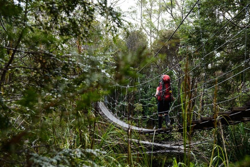
Contents
1. Summary ............................................................................ 1
2. Introduction ......................................................................... 3
  Background ................................................................................... 3
  Location, plan area and access ..................................................... 3
  Overarching vision and objectives ................................................. 3
3. Current situation ................................................................. 6
  Values of the Frenchmans Cap area.............................................. 6
     Cultural and heritage values ....................................................... 6
     Natural values ............................................................................ 7
     Climate and climate change ......................................................11
  Usage and visitor characteristics ..................................................13
     Visitor characteristics ................................................................14
     Commercial use ........................................................................14
     Non-commercial groups ............................................................15
  Existing facilities ...........................................................................15
     Walking tracks ...........................................................................15
     Huts and shelters ......................................................................18
     Campsites .................................................................................19
     Toilets .......................................................................................20
     Signs .........................................................................................20
  Existing recreational impacts ........................................................21
     Impacts on tracks ......................................................................21
     Impacts at campsites.................................................................21
  Other issues .................................................................................22
  Education and interpretation .........................................................23
  Adjacent areas..............................................................................24
4. Future recreation management ........................................ 25
  Overall strategy ............................................................................25
  Walking tracks ..............................................................................26
  Lake Vera overnight node .............................................................28
  Lake Tahune overnight node ........................................................31
  Toilets ...........................................................................................34
  Other camping ..............................................................................34
  Biosecurity ....................................................................................35
  Fires .............................................................................................36
  Commercial visitor services operators ..........................................36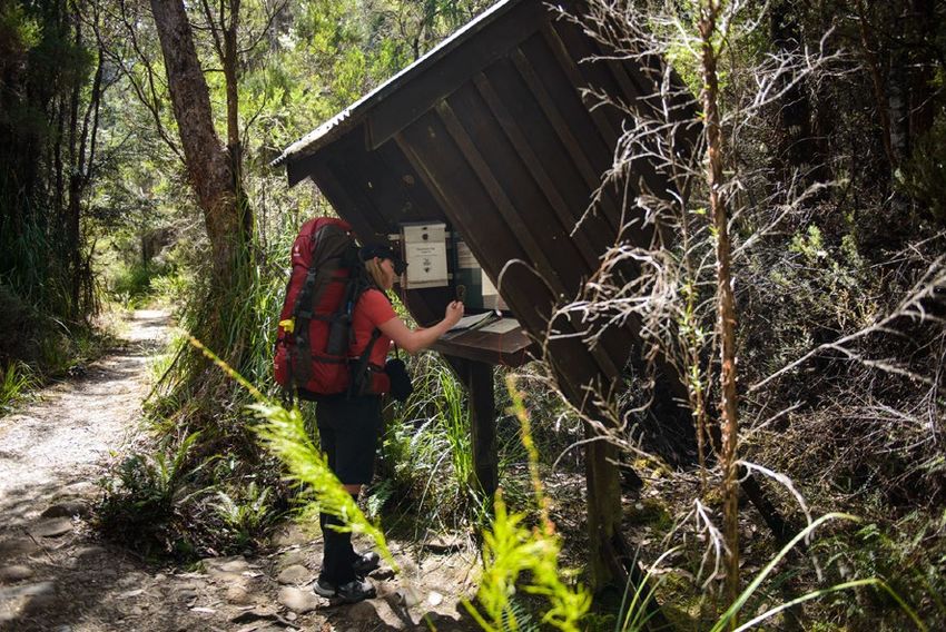
Groups ......................................................................................... 37
  Education and interpretation ......................................................... 37
  Other issues and strategies .......................................................... 39
5. Monitoring and evaluation ................................................. 40
     Review ...................................................................................... 43
6. Information sources & glossary ......................................... 44
  Glossary ....................................................................................... 47
7. Appendices ....................................................................... 48
  Appendix 1: Management Context................................................ 48
  Appendix 2: The Reserve Standards Framework ......................... 51
  Appendix 3: Track Classification Scheme ..................................... 52
  Appendix 4: Implementation Schedule ......................................... 57
  Appendix 5: Design Brief for Replacement Lake Tahune Hut ....... 59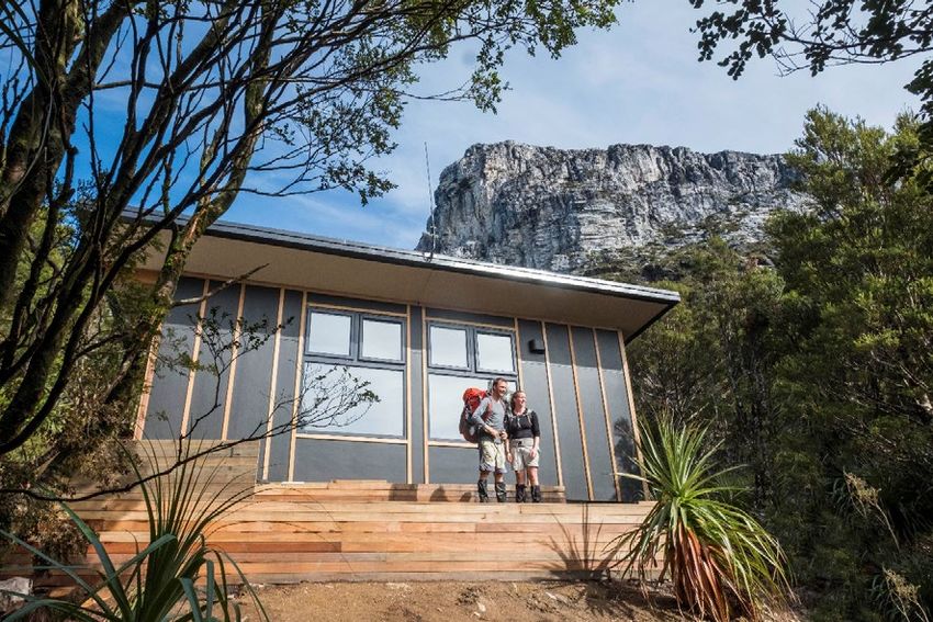
1. Summary
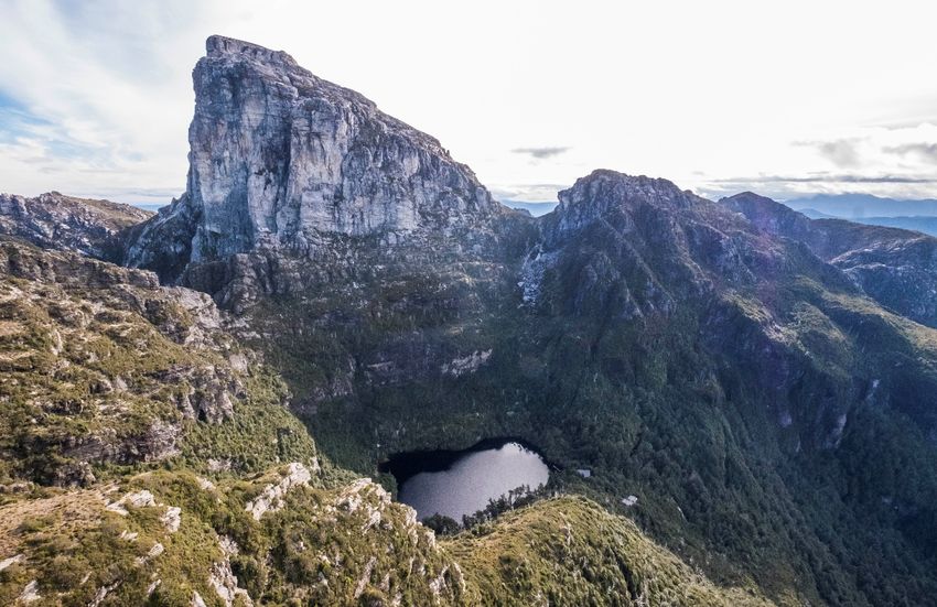
Frenchmans Cap (1,443 m) constitutes perhaps the most dramatic landform in western Tasmania.
Its prominent and distinctive shape made it a landmark before European settlement. The area has
a long history of both recreational use and reservation, with a national park in the area first
proclaimed more than 70 years ago.
The 45 km return walk to the Cap is a challenging experience but is, nevertheless, the fourth-most
popular backcountry-walking destination in Tasmania, with 1,832 people visiting in 2016-17.
Walkers typically undertake the return trek over four days. In almost 80 per cent of visitor nights
spent in the area, visitors use the public huts at Lakes Vera and/or Tahune for accommodation.
Apart from the Overland Track, Frenchmans Cap is the only backcountry walk in the Tasmanian
Wilderness World Heritage Area (TWWHA) where such a public hut-based walk experience is
possible.
Walkers are not the only recreationists who use the area. Frenchmans Cap has been popular with
rock climbers for more than 40 years and many traditional-style routes have been established on
its steep walls. The wild Franklin River’s gorges partly surround Frenchmans Cap and the
Irenabyss Track provides a recreational link for both rafters and walkers.
Several companies are licensed to undertake commercial walking trips; however, customer
demand for a guided experience has been relatively low to date.
Many sections of the main access track have been subject to construction or stabilisation works at
various times. Major PWS-funded works were undertaken during the 1980s and 1990s, mainly in
the higher altitude areas, with a focus on environmental protection. The most recent track work is
part of 10-year project, begun in 2008, facilitated by business person Dick Smith providing
$100,000 annually to the Wildcare Inc Gift Fund. A major part of this project has been the
construction of a new 4.5 km track section bypassing much of the ’Sodden Loddon’ plains. The
opening of this bypass in March 2013 resulted in an immediate 50 per cent increase in walkers,
with a lesser trend since, although walker numbers have continued to significantly increase.
In addition to the indisputable scenic and recreational values, aspects of the area’s flora and
geoheritage values are important. Rainforest and fjaeldmark communities are particularly
noteworthy environmental values of the Frenchmans Cap area. The large area of rainforest in the
Lake Vera–Barron Pass area contains large and very old specimens of King Billy and Huon pine,
and the Huon pines are among the highest altitude occurrences known. This forest is particularly
important given the fate of neighbouring rainforest areas destroyed in a 1966 wildfire. The summit
dome of Frenchmans Cap has summer temperatures that are among the coldest in Australia. It
provides habitat for several rare and uncommon plant species. The vegetation in this area is very
vulnerable to trampling damage because of the slow growth rates caused by the cold, windy
weather and the thin, low-nutrient soils.
The purpose of this plan is to outline the values and management issues that will need to be
addressed in coming years, describing actions that aim to protect both the area’s high conservation
values and the visitor experience. As the Frenchmans Cap Track becomes increasingly popular,
preserving its wild character while maintaining the self-reliant visitor experience will involve careful
planning. Management actions include:
• Maintain the main access track as a class T2 track. In this way, the Frenchmans Cap Track
retains its position (between the Overland and South Coast tracks, for example) as part of the
range of recreational walking experiences available in the TWWHA.
Frenchmans Cap Recreation Zone Plan 2020 1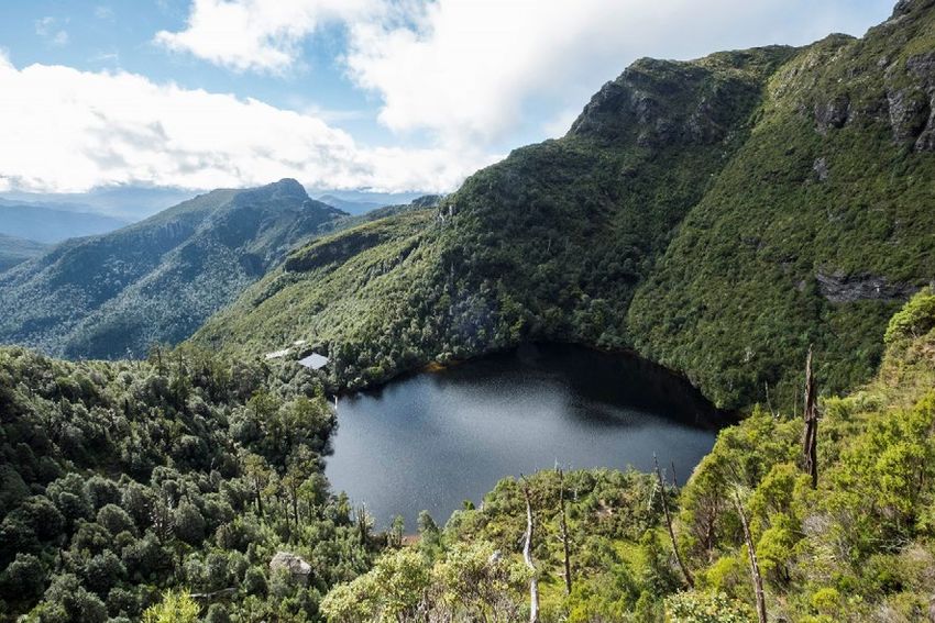
•   Repair and upgrade (consistent with the above) the remainder of the main access track.

•   Improve the site design at Lakes Vera and Tahune overnight nodes.

•   Replace the toilet at Lake Vera with a system appropriate for the climatic conditions and visitor
    numbers.

•   Maintain an ongoing seasonal ranger presence.

•   Develop and implement improved and consistent education and interpretation messages, to be
    presented both onsite and more broadly.

• Conduct track monitoring and visitor research, including exit surveys from summer 2018-19, to
  identify, evidence and inform issues and decision-making.

This plan is intended to apply for a 10-year period, at the end of which there is to be a thorough
review and evaluation of its effectiveness and the currency of its objectives and vision. There will
also be an interim evaluation after three years. The interim review will provide the opportunity to
review environmental monitoring and visitor research data and inform evidence-based decisions.

2     Frenchmans Cap Recreation Zone Plan 2020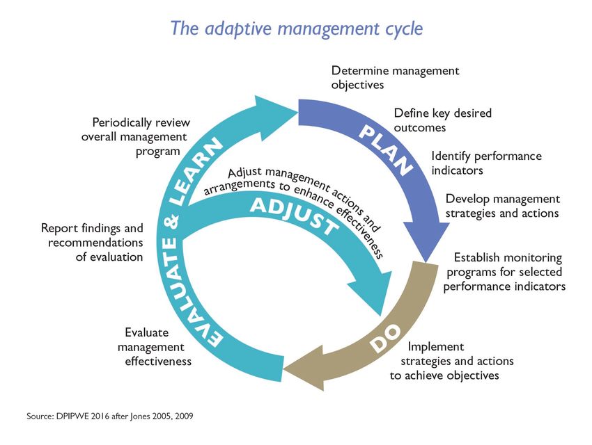
2. Introduction
Background
The Frenchmans Cap area is located in the Franklin-Gordon Wild Rivers National Park, part of the
TWWHA. An area at Frenchmans Cap was first proclaimed a national park in 1941. This was
absorbed into the Franklin-Gordon Wild Rivers National Park in 1981 and declared part of the
TWWHA in 1982.
The Franklin-Gordon Wild Rivers National Park covers more than 440,000 ha of reserved land. The
area most visited and used for recreational bushwalking is only part of the total reserve area and is
largely encompassed in the 6,596 ha Recreation Zone.
The statutory management plan for the TWWHA includes the Franklin-Gordon Wild Rivers National
Park and applies to the Frenchmans Cap Track. The TWWHAMP sets out what uses may occur in
the TWWHA, where they may occur and under what circumstances. It provides guidance on the
various uses of the TWWHA, primarily through a zoning and overlay system and an associated
Table of Use, as well as a number of specific prescriptions (DPIPWE 2016, p. 33).
Location, plan area and access
The Frenchmans Cap area is located in western Tasmania, immediately south of the Lyell
Highway. Access is via a major walking track starting at a car parking area adjacent to the highway
29 km west of Derwent Bridge.
In the TWWHAMP, Recreation Zone plans have been prepared to guide management in higher-
use areas including Frenchmans Cap Recreation Zone. The area covered by this plan is defined in
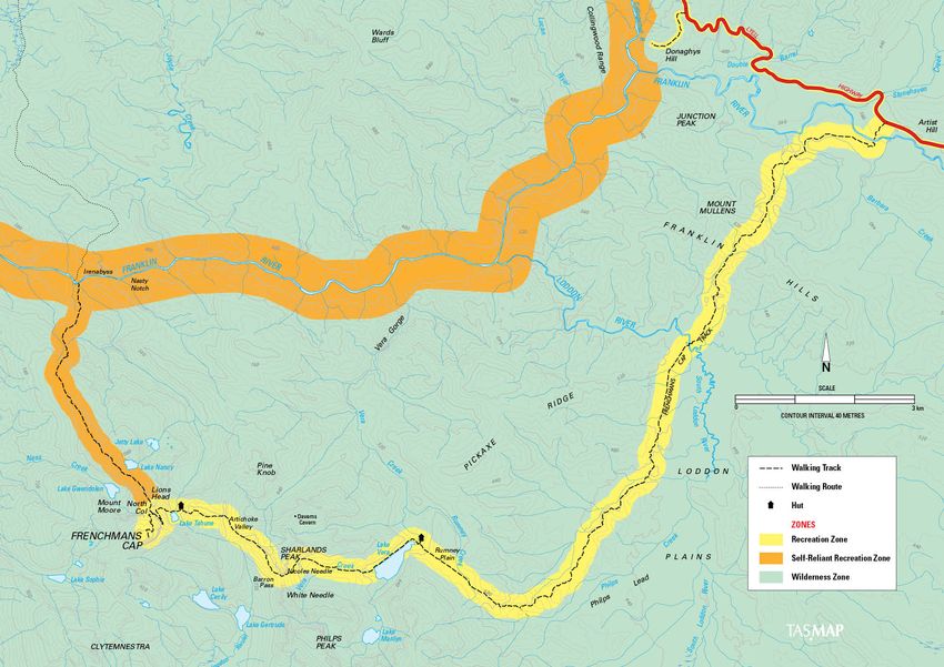
the TWWHAMP and referred to as the Recreation Zone. Map 1 (see page 5) shows the location of
the Recreation Zone and surrounding features.
The former Tasmanian Wilderness World Heritage Area Management Plan 1999 defined a more
extensive Frenchmans Cap Recreation Zone than the current Recreation Zone detailed in the
TWWHAMP. The former Recreation Zone allowed for the consideration of a loop track (see DPIWE
1999, p. 174). The idea of a loop track was investigated and abandoned given the difficulties
associated with construction, the cost and the impact on natural values. Consequently, the
Recreation Zone boundary defined in the TWWHAMP covers a 400 m wide corridor centred on the
existing walking track (see Map 1 on page 5).
A Recreation Zone corridor extends east and west along the Lyell Highway but, apart from the car
park vicinity, this is not part of the area covered by this plan.
Overarching vision and objectives
This Recreation Zone Plan is a subsidiary plan under the TWWHAMP, which is the statutory
management plan for the area. This Recreation Zone Plan complies with the relevant provisions of
the TWWHAMP, and where appropriate builds on these.
The guiding vision for management of the TWWHA, in line with the UNESCO World Heritage
Convention (Articles 4 and 5), is to:
Identify, protect, conserve, present and, if appropriate, to rehabilitate, the World Heritage, National
Heritage and other natural and cultural values of the TWWHA, and to transmit that heritage to future
generations in as good or better condition than at present.
Frenchmans Cap Recreation Zone Plan 2020 3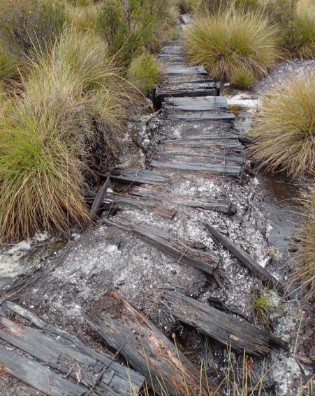
The National Parks and Reserves Management Act 2002 lists various objectives for management
of national parks, including protecting natural, biological and geological diversity, preserving
wilderness areas and water quality, as well as encouraging and providing for recreational use and
enjoyment consistent with the conservation of the national parks’ natural and cultural values. The
TWWHAMP objectives align with the Act and apply to this plan.

The overarching objectives of management in the TWWHAMP (DPIPWE 2016, p. 34) are:

Cultural Values
•   To develop and implement a joint management arrangement that ensures the strategies and
    actions for identification, protection, conservation and presentation of the World Heritage and
    other values of the TWWHA are developed in partnership with Tasmanian Aboriginal people.

•   To understand the TWWHA as an Aboriginal cultural landscape, reflecting its long occupation,
    as a foundation for management of its cultural values.

•   To identify, protect, conserve and restore cultural values in the TWWHA.

Natural Values
•   To identify, protect, conserve and restore natural biological and geological diversity and
    processes in the TWWHA.

•   To protect and conserve the natural landscapes of the TWWHA, particularly in areas of
    exceptional natural beauty, and aesthetic and cultural importance.

Presentation
•   To provide a diversity of visitor experiences in a manner that is consistent with the
    conservation of natural and cultural values.

Community Engagement
•   To promote and facilitate the role of the TWWHA as an integral and valued component of the
    social, environmental and economic wellbeing of the international, national and Tasmanian
    communities, and to involve these communities in its management.

Monitoring and Evaluation
•   To support the delivery of an informed, effective and transparent adaptive management regime
    for the TWWHA.

The Frenchmans Cap area was declared a Fuel Stove Only Area in 1989, and the entire Franklin-
Gordon Wild Rivers National Park was declared a Fuel Stove Only Area in 1998, meaning that
campfires cannot be used in the park.

4     Frenchmans Cap Recreation Zone Plan 2020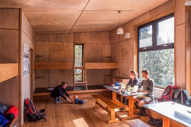
Map 1 TWWHA management zones for the Frenchmans Cap Track area

                                                                 Frenchmans Cap Recreation Zone Plan 2020   5
3. Current situation Values of the Frenchmans Cap area Cultural and heritage values Aboriginal significance and values The TWWHA is a diverse Aboriginal cultural landscape comprising a variety of environments in which the cultural heritage of Tasmanian Aboriginal people is preserved. For tens of thousands of years Aboriginal people lived in the coastal environments, the valleys with freshwater rivers, open button grass plains and alpine mountains. Archaeological research and excavations have shown that Aboriginal people lived in the TWWHA for at least the past 35,000 years and were, for 20,000 years, the southernmost people on Earth. Among the significant sites in the TWWHA is Kutikina, which is located in the lower Franklin Valley about 30 km from Frenchmans Cap, where occupation dates to at least 20,000 years. Research suggests that the nature of Aboriginal use and management of the TWWHA, including in areas around Frenchmans Cap, varied over time, with Aboriginal people adapting to live in the environment that was subject to extreme climatic change. The cultural practice and the unique adaptation and resourcefulness required for their ongoing occupation of the area are evidenced by the archaeological record. It reveals hunting and butchering strategies, use and transportation of available raw material, modification of the landscape through targeted firing regimes, glimpses into Aboriginal people’s spiritual life through artistic representations in rock shelters, and use of seasonal and coastal resources. A number of cultural heritage surveys have been completed in the Frenchmans Cap area, with a small number of sites identified. Despite this, there is a high probability of additional and currently unrecorded Aboriginal cultural heritage sites being located in the Frenchmans Cap area. Historical values and significance Europeans first explored the Frenchmans Cap area in the mid-1800s. Various, mostly short-lived, access tracks in the area were ‘cut’ for prospectors over the years to the early 1900s. J.E. Philp cut and marked the route that forms the basis for the current walking track beyond Laughtons Lead in 1910, although it was subsequently forgotten until rediscovered by bushwalkers in 1932. It had become a relatively common wilderness-walking destination by the 1940s. From the 1940s to 1970s, various efforts at clearing and maintaining the track for bushwalkers were undertaken, some voluntary and some by contractors. Various huts and campsites were established during this historical era, but little trace of any remains. Some of the benching on the current track (on Mt Mullens) dates from the 1930s. The remains of one of Philp’s camps exist near the now-closed track in Philps Lead. Tasmanian bushwalkers are acknowledged as historical users of the track and recognised for their significant contributions to the exploration and protection of the Frenchmans Cap walking track network. 6 Frenchmans Cap Recreation Zone Plan 2020
Natural values
Flora
The vegetation communities in the Frenchmans Cap area comprise buttongrass, wet forest and
scrub, rainforest and alpine communities, their distribution related to altitude, drainage, aspect and
                                                      fire history. Buttongrass sedgeland communities
                                                      dominate the country between the Lyell Highway
                                                      and Lake Vera, and there is Eucalyptus nitida
                                                      wet forest or scrub; the former blankets the open
                                                      plains while forest and scrub fringe drainage
                                                      lines. A large area of rainforest occurs in the
                                                      Lake Vera–Barron Pass area, with large and
                                                      very old specimens of King Billy pine (Athrotaxis
                                                      selaginoides) and Huon pine (Lagarostrobos
                                                      franklinii) both occurring here. The Huon pines
                                                      are among the highest altitude occurrences
                                                      known. This forest is an important value of the
Frenchmans Cap area, particularly given the fate of some neighbouring sites (see below). King
Billy pine also occurs in rainforest and alpine shrubbery beyond Barron Pass (although the
bleached fire-killed trunks of King Billy pines here indicate its greater extent before several
devastating bushfires).

Dwarf alpine rainforest and shrubberies, graminoid and cushion moorland, herb-field and
fjaeldmark communities occur in higher elevation and exposed settings and contain many endemic
species.

Wildfires affected the area in the 1890s, 1934 and 1966. The earlier fires killed some King Billy
pines, but the 1966 fire was particularly devastating in the Lake Tahune and Artichoke Valley
areas, resulting in the death of large swathes of King Billy pine alpine rainforest.

Volunteers at Lake Tahune undertook some replanting of King Billy pines and other species during
Easter 1967, but an assessment 25 years on concluded success was limited compared to natural
revegetation. Natural revegetation is still very slow, but young King Billy pines are prevalent in a
few areas at Lake Tahune (for example), facilitated by track drainage and hardening works limiting
trampling impacts. However, up on ‘Tahune Ridge’, where both vegetation and soil were lost during
the fire and its aftermath, it seems unlikely King Billy pines will ever return.

There are some threatened or otherwise significant species known from the area, but data is
limited. Vegetation communities of particular significance include the alpine areas (particularly
fjaeldmark), King Billy pine rainforest, King Billy pine-Nothofagus gunnii short rainforest, and King
                                                      Billy pine sub-alpine scrub. These communities
                                                      are considered important despite the impact of
                                                      wildfires.

                                                    Fjaeldmark has high conservation values and
                                                    limited distribution in Tasmania. It is sensitive to
                                                    trampling impacts. The summit dome of
                                                    Frenchmans Cap is of particular significance due
                                                    to its cold summer temperatures that provide
                                                    habitat for several rare and uncommon plant
                                                    species. The vegetation in this area is very

                                                           Frenchmans Cap Recreation Zone Plan 2020     7
vulnerable to trampling damage because of the slow growth rates caused by cold, windy weather and the thin, low-nutrient soils. Since the 1990s, the Frenchmans Cap area has been a focus of dendrochronology and climate research using Huon and King Billy pines (eg Cook et al 2006). At Lake Vera, both living and sub- fossil trees were sampled. The oldest living Huon pines sampled in the Lake Vera basin are more than 1,400 years old. Areas available for future dendrochronology research are limited (DPIPWE 2011, Fitzgerald 2012). Proposals for further sampling that may involve repeated access to off- track areas have the potential for unplanned routes/tracks to develop. Any increase in users associated with the upgraded track (see page 13) may result in additional impacts on trampling-sensitive alpine vegetation communities. Track hardening will be required to protect many of these communities. The summit dome of Frenchmans Cap and Artichoke Valley are two sites of particular concern. In recent years, an infestation of Phytophthora cinnamomi root rot fungus has been identified near the track on the southern Loddon Plains. This area is now bypassed by the newly opened re-route so, if the old track is not used, opportunities for the spread of the infestation by humans will be minimised. Tasmanian rainforest communities are susceptible to myrtle wilt, and track works in rainforest areas that may damage trees are therefore a potential concern. Climate change (see page 11) will also increase the risk of myrtle wilt. Fauna The Frenchmans Cap Recreation Zone contains many fauna values that contributed to the world heritage listing of the TWWHA. The dominant vegetation communities are alpine, rainforest (King Billy pine), wet eucalypt forest and moorland that, along with the freshwater habitats, contain many ancient taxa and Tasmanian endemic fauna. The living fossil, the Tasmanian mountain shrimp (Anaspides tasmaniae), is common in the alpine tarns, streams and lakes. Burrowing crayfish are found in alpine areas and in the moorlands, and a sister species of the giant freshwater crayfish (Astacopsis gouldi) is found in the rivers and streams. The area provides secure habitat for several species that are of conservation concern, such as the Tasmanian devil (Sarcophilus harrisii), spotted-tailed quoll (Dasyurus maculatus) and ground parrot (Pezoporus wallicus). The area is remote, largely undisturbed and contains very few invasive fauna species. While no formal records exist, track workers have seen feral cats on the new re-routed track west of Loddon Plains and Mt Mullens. Evidence of lyrebirds has been noted in the Frenchmans Cap area recently. This is further west than previously recorded observations and indicates the slow migration westwards of this introduced species is continuing. No significant ecological impacts are known, but the birds contribute to infill of trackside drains and so increase the need for track maintenance. Devil facial tumour disease has not been recorded in the Recreation Zone but is known from the Derwent Bridge area, and it is possible the disease is in the zone. Spread of the disease is from devil to devil but it is believed that tracks, roads, and perhaps planned burns opening up vegetation may facilitate disease spread. The area provides important habitat for the Tasmanian tree frog (Litoria ewingi), which is ranked as at extreme risk from chytrid frog fungus. Chytrid frog fungus is known to occur along the Lyell Highway, so prevention of anthropogenic disease spread to populations in the Recreation Zone is 8 Frenchmans Cap Recreation Zone Plan 2020
a high priority. This involves education of the public, and particularly management staff, and the
use of wash-down stations at the main trailhead.

Most walking and camping-based recreational activities will have limited impact on fauna values
unless walkers cause fires or a decline in water quality.

Water quality
Surveys of surface water quality have not been undertaken at Frenchmans Cap, but it is likely to be
similar to other comparable parts of the TWWHA, with low nutrient levels consistent with the largely
pristine nature of the catchments. Bacterial levels are likely also very low, but probably do not
comply with National Water Quality Management Strategy 2011 drinking water quality guidelines
for bacteria, which is typical for natural surface waters due to native animal droppings etc. Camping
and, in particular, toileting and washing by recreational visitors, have the potential to impact on
water quality and so impact both environmental values and the visitor experience.

The siting of existing toilets is unlikely to cause any water contamination.

Both Lakes Vera and Tahune huts have associated drinking water tanks with roof collection. There
is no regular water quality testing, but signs identify and qualify the risk to users.

Geoheritage

Frenchmans Cap | PWS | Chris Crerar

Bedrock in the Frenchmans Cap area comprises Precambrian quartzite and schist, with some
dolomite occurring with schist within a band encompassing Artichoke Valley, Lake Tahune and
Jetty Lake. These ancient rocks have been folded and metamorphosed several times during their
billion-year history, and it is their contorted nature and resistance to erosion of the quartzite, in
particular, that provide the basis for the area’s spectacular scenery.

The area hosted up to eight glacier systems on several occasions during the last million years or
so. The most recent glaciation ended a mere 14,000 years ago. Erosion by the glaciers

                                                           Frenchmans Cap Recreation Zone Plan 2020     9
themselves, and sediment-laden outwash streams, has shaped the present landscape. The vicinity of Frenchmans Cap contains one of the most impressive suites of glacial landforms in Australia, with both erosional (cirques, horns, serrated ridges, meltwater gorges) and depositional (moraines, outwash deposits) features common. Some lake basins contain sediments with long post-glacial environmental records; for example, charcoal in a recent sediment core from Lake Vera spanning at least 19,000 years indicates a high fire frequency in the region between 17,000 and 11,000 years ago. Organic soils are virtually ubiquitous throughout the region and blanket undulating terrain in response to a humid climate. These organosols and their soil-forming processes are considered of international significance. Organosol surface horizons generally overlie gravelly (usually quartzitic), sandy mineral soils. However, both the organic and/or mineral soil horizons may be quite thin, especially in higher or more exposed localities. Slopes dominated by sedgeland may have 0.6 m deep organic soils, with both fibrous and muck horizons, overlying quartzitic gravels. In contrast, rainforest soils have a thin fibrous organic horizon overlying clay loam or loam mineral horizons. Bare soil occurs in particularly exposed alpine localities (fjaeldmark). Soil-forming processes in the alpine country are exceedingly slow. The Frenchmans Cap area contains a number of significant sites listed in the Tasmanian Geoconservation Database, but most are quite robust to walker-related impacts. Some of these aspects of the area could be usefully promoted in any interpretation. Scenic, wilderness and recreational values Frenchmans Cap (1,443 m) constitutes perhaps the most dramatic landform in western Tasmania. Its prominent and distinctive shape made it a landmark from the earliest days of European settlement, and it features in many historical accounts of early exploration and bushwalking. The values of the Frenchmans Cap area were acknowledged by the proclamation of a 9,550 ha national park encompassing the region in 1941. The wilderness values of the TWWHA are of significant importance. The extensive remote and largely undisturbed country forms the tangible component of wilderness value in the TWWHA. Wilderness is also valued for the recreational opportunities it provides as well as from a social and intrinsic perspective. The Frenchmans Cap Recreation Zone is a corridor for recreational travel through to the adjacent area zoned as Wilderness. Wilderness quality has been mapped across the TWWHA using a modified version of the National Wilderness Inventory technique (Hawes 2005). While the track and huts have some negative influence, the 2015 mapping indicates most of the Recreation Zone remains high wilderness quality (wilderness values equal to or greater than 12 and up to 18). Key Desired Outcome 8.5 of the TWWHAMP (DPIPWE 2016, p. 175) is ‘Wilderness is managed for the protection of the integrity and the natural and cultural values of the TWWHA and the quality of the recreational experience it provides’. In order to protect wilderness values in the TWWHA, the TWWHAMP (DPIPWE 2016, p. 177) commits to ensuring that impacts on wilderness values are considered in any assessment of activities in the TWWHA. There is significant contemporary social value associated with recreation to areas such as Frenchmans Cap, and also increasing recognition of the significance of the spiritual and 10 Frenchmans Cap Recreation Zone Plan 2020
therapeutic values of the TWWHA, a theme acknowledged in the TWWHAMP (DPIPWE 2016,
p. 49).

Frenchmans Cap has been a relatively popular bushwalking destination since at least the 1940s,
such that walker huts were first constructed at Lake Tahune in 1947 and Lake Vera in 1962, and
intermittent works to maintain or clear the track were undertaken during the same period.

The 2006 Great Bushwalk Scoping Study concluded that Frenchmans Cap was primarily a
destination-style walk with outstanding scenery and considered a medium-hard walk for
experienced walkers.

                                  The scenic values of the area also make it a focus of some
                                  commercial scenic flights, subject to Fly Neighbourly Advice
                                  Tasmanian World Heritage Area and Mount Field National Park.

                                  Rock climbers appeared on the scene in the early 1960s, no
                                  doubt attracted by the spectacular unclimbed walls. Today, all
                                  major features have been climbed, some via several routes.
                                  There are more than 70 established rock-climbing routes in the
                                  Frenchmans Cap area, from single-pitch challenges to the classic
                                  400 m lines on the towering east and south-east faces. All
                                  climbing at Frenchmans Cap has been traditional free climbing
                                  with little or no use of permanent anchors (bolts). Climbers often
                                  spend several days in the Cap area, usually based at Lake
                                  Tahune Hut.

                                  The high vertical cliffs of Frenchmans Cap first attracted BASE
                                  jumpers in the 1980s and continue to be used occasionally for
this activity.

In recent years, small numbers of walkers undertaking pack-and-paddle trips have appeared,
walking in or out via the Frenchmans Cap Track after pack rafting on the Franklin River.

The Frenchmans Cap Track currently offers a medium-length camping trip for self-reliant
bushwalkers, a recreational opportunity that should be viewed in at least a regional or TWWHA-
wide context.

The 1997 Tasmanian Walking Tracks Strategy and Marketing Plan identified eight Great
Bushwalks, having considered their potential for promotion and marketing as key overnight walking
experiences in Tasmania. Frenchmans Cap was one of these bushwalks, but its adoption as such
was not advocated as part of the initial strategy.

Climate and climate change
The Frenchmans Cap area ranges from less than 300 m to 1,443 m elevation, with a consequent
wide range of microclimates. Mt Read (near Rosebery), the closest and most similar locality with
meteorological data records, has a mean temperatures range between 6.3 to 14.3 degrees in
February and 0 to 3.6 degrees in July. The wettest months at Mt Read are May to October but
precipitation occurs all year, with an annual total rainfall of more than 3.6 m: the wettest recorded
place in Tasmania. Frenchmans Cap is likely even wetter than the Mt Read annual totals, perhaps
nearer to 4 m in total annual rainfall.

The maritime climate of Tasmania is associated with a lack of persistent snowline in winter and
snow that falls at any time of the year. Nevertheless, winter snowfall is common at higher

                                                         Frenchmans Cap Recreation Zone Plan 2020   11
elevations, and snow can lie for extended periods (well into summer) at some localities around the
Cap itself. This climate has significant implications for both users (comfort and safety) and
managers (servicing and design of facilities, rehabilitation of any disturbed areas).
Climate change modelling for Tasmania through the 21st century indicates a progressive increased
seasonality of precipitation, with increased winter and decreased summer rainfall in western
Tasmania. A general mean warming of 1 to 2 degrees is also predicted, with resultant increased
drying in summer. It is important that any management investment in the area now and in the
future is consistent with the likely impacts of climate change.
In terms of the environment, this climate change will mean changed fluvial processes (eg seasonal
run-off), perhaps increased landslip risk and a reduction in alpine freeze/thaw processes.
Increased seasonal drying and fire will progressively degrade the organosols. Species such as
King Billy pine, thought to be limited by low summer rainfall, will be directly affected by this
seasonal drying.
Fire
The Frenchmans Cap area provides stark evidence of the fire-sensitive nature of some vegetation
communities and soils. Wildfires affected the area in the 1890s and 1934, and a devastating
wildfire in 1966 destroyed alpine vegetation and many of the remaining conifers throughout the
main range. An escaped campfire at Lake Vera burnt
6,450 ha in 1980.
Fire risk analysis indicates a low to moderate fire risk for
most of the Recreation Zone. However, the area between
Lake Vera and Artichoke Valley has a high risk due to the
presence of a ‘major’ value, the unburnt rainforest
containing fire-sensitive species (Huon pine, King Billy
pine etc). The persistence of these conifers indicates this
area was a fire refuge and should be managed for its
protection.
Fire potentially affecting the Frenchmans Cap area may
result from external factors that are beyond the scope of
this plan; however, unauthorised campfires are a
potential ignition source. The Recreation Zone has been
a Fuel Stove Only Area since 1989.
The Lake Vera hut is surrounded by flammable vegetation. Some vegetation clearance in recent
years has improved the situation, but the hut is indefensible in the case of a major wildfire.
Nevertheless, the hut precinct itself is the likely source of a minor fire, and hut modifications or
modest vegetation clearance (for example) may assist in saving the structure during such a small
fire.
The Frenchmans Cap Emergency Response Plan 2017-2018 provides guidance for quick but
comprehensive initial response by PWS staff to any emergency reported in the Frenchmans Cap
area. While the Emergency Response Plan has a focus on protecting people ahead of built assets
and natural values, the protection of the latter remains a high priority given the fire sensitive nature
of the alpine vegetation. Emergency fire evacuation plans exist for Lakes Vera and Tahune huts
(with signs and maps at each hut indicating lake refuges etc).
There has been some recent management burning on the Loddon Plains for ecological and asset
protection reasons, and more may be planned in future.
12 Frenchmans Cap Recreation Zone Plan 2020While beyond the explicit scope of this plan, the broader issue of wildfires originating beyond the
boundaries of the Recreation Zone or national park are addressed as part of the PWS Northwest
Region Strategic Fire Management Plan 2012. Under the current version of the Bushfire Risk
Assessment Model (BRAM) used by the Fire Management Plan, the values at risk in the
Frenchmans Cap area are considered ‘major’. Any wildfire threatening values, whether external or
internal to the Recreation Zone, should be a high priority for suppression.
Usage and visitor characteristics
Frenchmans Cap is the fourth-most popular overnight backcountry-walking destination in Tasmania
(after the Overland Track, the Three Capes Track and the Walls of Jerusalem). The Recreation
Zone provides an accessible but challenging wilderness bushwalking experience in a spectacular
mountain setting.
Usage of the Frenchmans Cap area (based on the registration record) has varied year to year over
the 30 years for which records are available (see Figure 1 below). During the period up until 2013,
walker numbers per annum were mostly between 600 and 800, with a peak in use in 2007-08 that
bumped numbers up over 1,000 walkers per year.
The opening of the bypass track around the ‘Sodden Loddons’ in March 2013 resulted in a
dramatic increase in walkers in 2013-14 to 1,450. This was expected, given the reputation the
‘Sodden Loddons’ had for being extremely wet and muddy. Walker numbers have continued to
significantly increase since, with 1,832 walkers visiting Frenchmans Cap in 2016-17 and 1,675 in
2017-18.
Figure 1 Estimated annual visitation to Frenchmans Cap
Frenchmans Cap Recreation Zone Plan 2020 13Annual totals are based on logbook registrations until 2012-13. The 2013-17 totals (black bars) are
primarily based on recently installed IR counter data but are supported by logbook registrations
and track ranger surveys, which indicate very high registration compliance.
Visitor characteristics
Data from 2006-07 and 2010-13 indicate walker parties spent an average three nights in the
Frenchmans Cap area, with Lake Vera used much more than Lake Tahune for overnight stays.
The median trip duration during extended holiday periods (eg Easter 2014) is a slightly longer four
days.
Verbal surveys by the track ranger of more than 120 parties during the 2013-14 season indicate
Lake Vera hut is used for almost twice as many nights as Lake Tahune. The same surveys indicate
77 per cent of visitor nights in the area were in the huts, rather than camping, but that of visitor
nights spent at either Lakes Vera or Tahune, 83 per cent were in the hut.
Analysis of walker registration data from the 2010-13 period indicates that:
• Fifty-six per cent of walkers (52 per cent of parties) were from Tasmania, 35 per cent of
walkers (37 per cent of parties) were from interstate, and less than 7 per cent of walkers (9 per
cent of parties) were from overseas. Interestingly, these proportions are virtually identical to
those from a limited survey undertaken in 1994-95. They are also similar to those for visitors to
the Walls of Jerusalem, another accessible backcountry Recreation Zone.
• Surveys undertaken by the track ranger during 2013-14 recorded a slightly higher overall
proportion of overseas walkers (11 per cent) and mainland walkers (39 per cent) compared to
Tasmanian walkers (50 per cent), but this may be a reflection of more seasonal (peak summer
season) visitation by non-Tasmanian walkers.
• Average party size was 2.5 walkers, with average Tasmanian parties larger (2.7 walkers) and
overseas parties smaller (less than 2.1).
• Ninety per cent of all parties comprised four walkers or fewer, and 75 per cent of all walkers
travelled in parties of four or fewer. The most common group size was two walkers (45 per cent
of all walkers are in groups of two). The maximum registered party size was 12.
• The average walk duration was 2.6 nights (ie 3 to 4 days).
• Almost 80 per cent of walkers went to Frenchmans Cap (as distinct from stopping somewhere
short).
• Registration data suggests 4.5 per cent of walkers visited Irenabyss as a side trip, and a further
2.5 per cent intended to exit via Irenabyss to the Raglan Range. Four per cent of walkers
indicated some other side trip (eg Daverns Cavern, Philps Pk, Clytemnaestra, rock climbing)
was undertaken. Verbal surveys by the track ranger during 2013-14 confirm Irenabyss is the
most popular side trip and indicate it was attempted by almost 10 per cent of walkers.
Visitation is quite seasonal. The peak month for visitation is usually January (22 per cent of total
visitation during 2010-13), with almost 70 per cent of visitation generally occurring during the
December to March period. However, in 2014, April was the peak visitation month for the 2013-14
season (Easter fell in April that year).
Commercial use
An aim of Recreation Zones, as described in the TWWHAMP, is to support commercial use. In
particular, guiding companies provide the opportunity for walkers to visit zones, such as
Frenchmans Cap, who otherwise may not have the confidence or experience to visit.
14 Frenchmans Cap Recreation Zone Plan 2020Twelve commercial guiding companies are licensed to use the Frenchmans Cap Track, although
fewer than half actually advertise Frenchmans Cap as a potential trip. Party sizes of up to 13 are
permitted, consistent with the track’s T2 prescriptive classification, although most groups are
smaller than this. Guided walking companies currently operating at Frenchmans Cap run one to
two trips per season, with customer demand for a guided experience relatively low to date.
The four companies undertaking guided Franklin River rafting trips are also licensed to guide
clients on a side walk to Frenchmans Cap, using the track from Irenabyss to North Col. This occurs
several times each summer and is weather dependent.
Commercial scenic flights operate over many parts of the TWWHA. There is no capacity under the
National Parks and Reserves Management Act, the TWWHAMP or this plan to regulate the use of
airspace over reserved land. Regulation of over flights is limited to the voluntary Fly Neighbourly
Advice, which is generally adhered to by commercial operators who conduct operations in the
TWWHA (DPIPWE 2016, p. 134).
For the purposes of the voluntary Fly Neighbourly Advice, an area encompassing the Frenchmans
Cap Recreation Zone is designated a ‘sensitive area’. With respect to the designated sensitive
areas, this advice states:
• flights in and through Sensitive Areas should be kept to a minimum; and
• aircraft should be operated at an altitude and configuration that will minimise noise and visual
impact for ground observers.
There have been no formal complaints from walkers during the last ten years, suggesting
reasonable acceptance of aircraft use within existing limits.
Commercial aircraft landings in the Frenchmans Cap Recreation Zone are subject to the following
condition: except for the purpose of resupply of huts or standing camps, landings will not be
permitted within 200 m of the Frenchmans Cap Track (DPIPWE 2016, p. 135).
Non-commercial groups
The Frenchmans Cap area receives limited use by school groups and individuals leading outdoor
education programs. Observations by the seasonal track ranger suggest such use has declined in
recent years, and this is supported by the relative lack of applications for educational exemptions
from national park fees. However, improved track conditions and a new hut at Lake Tahune may
generate increased interest from school groups.
Existing facilities
A range of facilities has been developed in the context of the PWS Reserve Standards Framework
(RSF). The RSF is a strategic planning mechanism developed by the PWS to define and maintain
acceptable levels of public risk and to establish standards for the provision and maintenance of
services and facilities throughout the park system (refer to Appendix 2).
Walking tracks
The PWS Walking Track Classification System (PWS 2011, Appendix 3 of this plan) grades tracks
on reserved land in accordance with a range of criteria to provide guidance to land managers on
the appropriate level of development for walking tracks and campsites.
The Recreation Zone contains three walking tracks totalling 27.1 km, plus almost 10 km of
recognised routes.
Frenchmans Cap Recreation Zone Plan 2020 15Table 1 Track classification and total track length
PWS Track Class Total track length in Recreation Zone (km)
T1 0.37
T2 21.8
T3 5
Total tracks 27.1
Route 9.8
Some of these routes continue into the neighbouring Wilderness Zone, notably the 12 km route
north from Irenabyss to the Raglan Range. Track classifications range from T1 to Route (see table
above and Appendix 3 for details).
The short walk to the Franklin River swing bridge is
managed as a T1 track and is used by many passing
car-borne tourists. The main track beyond here (Franklin
River to Frenchmans Cap) is classified T2; this is a ‘wet
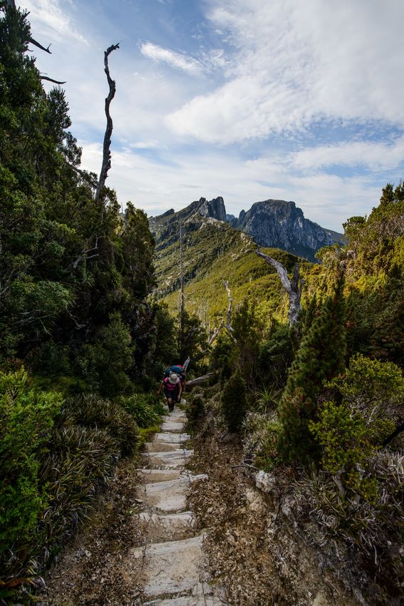
boot’ standard walking track (example at left). The other
major track is the T3 classified Irenabyss Track.
The Recreation Zone also contains more than five km of
closed track, above Lake Tahune (0.15 km) and in the
Loddon Plains–Philps Lead area (4.9 km), due to the
construction of major re-routes in 1993 and 2010-13
respectively.
Many sections of the main access track have been
planned and constructed at various times (see below)
but other sections and most side routes have evolved
from routes repeatedly used by walkers and hence are
unplanned, with sections aligned for ease of access rather than long-term stability or robustness.
Extensive works were undertaken on the Frenchmans Cap Track between 1983 and 2005, latterly
guided by the Walking Track Management Strategy for the TWWHA 1994 and therefore focused
on the most environmentally sensitive or least resilient areas. During this period, more than
$800,000 was spent on track works at Frenchmans Cap. Virtually all of the works considered the
highest priority, principally priority erosion control and stabilisation of tracks in alpine and steep
areas, were undertaken by the early 2000s.
As of September 2017, approximately 76 per cent (18 km) of the main track has been constructed,
hardened or stabilised in some way; this includes stonework, boardwalk, planking, gravel surfacing
or turn piking, and benching. The 5 km Irenabyss Track features over 600 m of stonework plus
1 km with stabilising steps and water bars.
16 Frenchmans Cap Recreation Zone Plan 2020These works largely controlled impacts in alpine areas and on Mt Mullens (although some areas
now require supplementary works and maintenance). Rock (readily available above 1,100 m) was
used for track works in many parts of the alpine area and produced an aesthetically pleasing and
long-term solution to impact problems. For example,
parts of the track along the ridge tops to the Irenabyss
constructed from local rocks appear to have lasted well
and are a good example of what is possible in areas
where rock is available.
The late 1990s period included work on the traverse of
the steep cross-slope around Lake Vera using local logs,
rock slabs and tree buttresses. Despite the challenge of
this section, it has received many walker compliments
for its organic feel.
Despite these 20 years of intermittent works, as of 2005,
some 5.3 km of mostly wide, braided, boggy and/or
eroding track remained on the Loddon Plains and Philps
Lead, but this has now been addressed, as a result of a
philanthropic gesture.
Concerned about the condition of the Frenchmans Cap Track after a visit in early 2008,
business person Dick Smith approached the Tasmanian Government to jointly fund repairs. An
agreement was reached between Dick Smith, the PWS and Wildcare Inc, whereby Dick Smith,
over a period of 10 years, would donate $100,000 annually to the Wildcare Gift Fund to support
maintenance and upgrade of the track, and the State Government would continue to provide
$50,000 annually to the project. Wildcare Inc manages the allocation of the donations received
from Dick Smith.
A Track Management Plan was prepared in 2008 to guide this significant investment. One of its
major recommendations was the construction of the re-route bypassing the southern Loddon
Plains and Philps Lead (other re-routes had been proposed in 1977 and 1991 but not proceeded
with). The track plan also contained prioritised recommendations for the upgrade and repair of the
entire track.
Track work funded via the Wildcare Gift Fund began in 2009, with costed works programs being
approved by the Gift Fund. Works undertaken include track hardening on the north Loddon Plains
and east of the Loddon River suspension bridge, and construction of a new 4.5 km track up
Laughtons Lead (the west-trending valley north of Philps
Lead). With the opening of this re-route in March 2013,
the extensive, seriously muddy and degraded ‘Sodden
Loddons’ have been bypassed.
Further repair and upgrade works on the existing track
remain to be tackled (as outlined in the 2008 Track
Management Plan) during the remaining year of the Dick
Smith funding agreement, which expires in 2019.
However, even now, the Frenchmans Cap walk is a
slightly easier and potentially more attractive
undertaking than it has been for the last 80 years.
Frenchmans Cap Recreation Zone Plan 2020 17Elevated structures
Major elevated structures on the track comprise the 42 m Franklin River swing bridge (built in
1992) and the 40 m Loddon River suspension bridge (built in 1989). The former replaced a flying
fox that was operational from 1949 to 1991. The
latter replaced a log crossing in use from 1960
until 1988.
Three other significant bridges exist: near the
Lyell Highway, at the east end of Laughtons
Lead and at Vera Creek. Flights of stairs exist at
Artichoke Valley and near Lake Tahune.
Several ladders or stepped logs exist around
Lake Vera and below Barron Pass.
Visitor risk
Under the PWS RSF, the main Frenchmans Cap Track is considered a Bushcamping Backcountry
(mid) setting (see Appendix 2), in which a ‘substantial’ level of visitor risk is acceptable. There are
some sections of the track where there is an increased risk to visitors (eg an exposed step-down
on a bluff approaching Artichoke Valley, a small cliff scramble on the summit track). Using the
calculator in the PWS Risk Register (based on the National Safety Council of Australia’s Risk
Score Calculator), these situations are acceptable in the above context.
The track and major built structures (eg bridges) are constructed to comply with different standards
and assessments and are managed differently. It is not appropriate to assess visitor risk for these
structures using the method outlined above. For this reason, different levels of barriers and other
safety features may be required on major built structures that are not required near cliffs and other
natural hazards associated with the walking track.
Minor built structures including ‘track features’ (eg ladders and steps cut into logs) do not
necessarily fit into either of the above categories and may need to be assessed for visitor safety on
a case-by-case basis.
Huts and shelters
Walker accommodation huts exist at Lakes Vera and Tahune. These public huts are open to all
comers; there are currently no private huts on the track. Almost 80 per cent of visitor nights are
spent in these huts (see page 14). The huts are understandably relatively more popular during
periods of wet weather.
These overnight nodes also contain campsites and toilets (see page 19 & 20). Each site also has a
designated helipad for management and emergency access.
Lake Vera hut is a 15 km walk from the Lyell
Highway and is a typical first-night destination for
walkers. This hut is the most popular overnight
site in the area (see page 14). Most walkers
spend additional nights here on their return walk
or as a base for a Frenchmans Cap day walk
attempt. Built in 1979, the hut was built to design
standards of that time and consists of a timber
structure with corrugated iron roof. It
18 Frenchmans Cap Recreation Zone Plan 2020accommodates 20 to 24 people on four sleeping
benches. It is in good condition and is
structurally sound.
Lake Tahune hut is an arduous additional 5.5 km
from Lake Vera hut. The original hut was built in
1971 (and refurbished in 1994). In 2017, work
started to replace this hut. The new hut and
envelope is designed to cope with extreme snow
loads and wet conditions. Non-combustible
materials for external walls are used to withstand
Inside Tahune Hut | PWS | Chris Crerar
a possible bushfire. Construction materials were
chosen for their longevity, low maintenance and low environmental impact. The expected life of the
hut is over 100 years.
The increased floor area of the new hut is adequate to comfortably provide for 24 occupants. A
generous amount of shelving and hanging space will assist with stowing of belongings. Eighteen
people in total can be seated at tables, with extra cooking benches provided. The large northern
windows in the dining area capture views and sun, contributing to the comfort of occupants. A high
level of energy efficiency is achieved through significant levels of insulation to walls, roof and floor,
and triple glazing and large windows to the north. A heat exchange ventilation system prevents
condensation in the hut, while retaining an ambient air temperature.
Lake Vera hut is currently heated using a briquette-fuelled potbelly stove. Briquettes have recently
become scarce and difficult to source; therefore, an alternative source of heating will need
assessment. The Lake Vera stove is exempt from the Fuel Stove Only requirement declared over
the remainder of the national park (see page 4).
The new Lake Tahune hut is passively heated, relying on internal gains (heat generated by cooking
and occupants) and the sun. Additional electric heating is provided, powered by a small-scale
hydro power plant.
Both huts also have associated drinking water tanks with roof collection.
The TWWHAMP, through the zoning of the walking track as a recreation zone, supports the
continued use of these huts and identifies them as important infrastructure contributing to the
experience of those visiting.
A three-sided treated pine shelter, containing bench seats and interpretive panels, is located in the
car park adjacent to the Lyell Highway. It was built in 2008 and the structure remains in good
condition. This shelter is associated with the gravel and bitumen-surfaced roadside car park, which
contains marked spaces for 23 cars. Car park
capacity has proven adequate at all times, but
toileting and rubbish issues have been noted in
the vicinity.
Campsites
Until recently there were no constructed or
specifically designated campsites on the
Frenchmans Cap Track; all sites used for
camping were unimproved and evolved from
walker use.
Frenchmans Cap Recreation Zone Plan 2020 19You can also read