ANCHOR - UTHONGATHI ESTUARY MANAGEMENT PLAN SITUATION ASSESSMENT DRAFT REPORT - Anchor ...
←
→
Page content transcription
If your browser does not render page correctly, please read the page content below
UTHONGATHI ESTUARY MANAGEMENT PLAN

       SITUATION ASSESSMENT

                DRAFT REPORT

                   January 2021

              ANCHOR
              e n v i ron me nta l
       Anchor Research and Monitoring Report No. 1905/3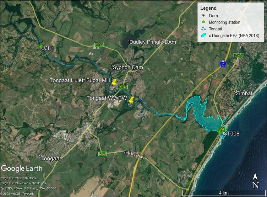
UTHONGATHI ESTUARY MANAGEMENT PLAN:
                                  SITUATION ASSESSMENT
                                            DRAFT REPORT

                                               January 2021

                                         Report prepared for:
                                       Province of Kwazulu-Natal
                                 Department of Economic Development,
                                   Tourism and Environmental Affairs

                                       Report Prepared by:
                             Anchor Research and Monitoring (Pty) Ltd
                  Suite 8 Steenberg House, Silverwood Close, Tokai, South Africa
                                   anchorenvironmental.co.za

                                         ANCHOR
                                         e n v i ron me nta l
                      Authors: Jessica Dawson, Safiyya Sedick and Barry Clark,

Citation: Dawson J, Sedick S and Clark BM. 2021. uThongathi Estuary Management Plan Situation Assessment
Draft Report no. 1905/3 prepared by Anchor Research & Monitoring (Pty) Ltd for the KwaZulu Natal Department
of Economic Development, Tourism and Environmental Affairs (EDTEA).

                                   © Anchor Research & Monitoring (Pty) Ltd
    Use of material contained in this document by prior written permission of Anchor Research and Monitoring only.
                                           Cover photo credit: Google Earth
ANCHOR
                                                                                        e n v i ron me nta l

                              EXECUTIVE SUMMARY
Introduction

This Situation Assessment report for the uThongathi Estuary provides a framework of relevant and
available information that enables the development of the Estuary Management Plan, as stipulated
under the National Environmental Management: Integrated Coastal Management Act 2008 (As
amended in Act No 36 of 2014) (ICMA Act). The report provides an overview of the spatial and physical
characteristics of the uThongathi Estuary, describes the current state of the estuary and provides a
review of the legal framework relevant to the system; a summary of the social and economic context
including land-use patterns; a description of the estuaries biophysical characteristics; assessments
undertaken in relation to ecological water quality and quantity, flow rates and ecosystems goods and
services and related management recommendations; management opportunities and constraints;
and information gaps currently faced in the system.

Catchment characteristics

The uThongathi Estuary is located approximately 35 km north of Durban in the vicinity of the King
Shaka International Airport and falls on the boundary between the eThekwini Metropolitan and
iLembe District Municipalities. The estuary is just under 6km long from mouth to head, with an
estimated estuarine area of 37 ha. Anthropogenic impacts acting on the estuary include commercial
sugar cane farming; residential development; two bridges (the M4 bridge located ±100 m from the
mouth and N2 Bridge just short of 5 km upstream of the mouth), a causeway 2.5 km from the mouth
and the discharge of wastewater into the river just upstream of the estuary head. Being a small
estuary that experiences strong wave action from the adjacent sea, as well as high levels of
sedimentation has resulted in the development of a perched estuary (a system with a raised berm and
a resulting water level that is higher than that of the adjacent sea level) and a constricted mouth which
limits the extend of tidal intrusion.

Located within a summer rainfall region, the system consists of two quaternary catchments areas
totalling 423 km2 in size. Water flow that is diverted to the two dams located on a small tributary just
off the main river system, is supplemented by the addition of wastewater into the river from the
Tongaat Central Wastewater Treatment works. The systems Natural Mean Annual runoff (nMAR) is
approximated at 70.79 million m3 per year, however, the present Mean Annual Runoff (pMAR) is
estimated to be 79.2 million m3 per year. The majority of the land surrounding the uThongathi estuary
is under cultivation in the form of sugarcane farming. Additionally, low-density and rural settlements,
the uThongathi Town and industrial area, and residential developments are present in the lower
catchment and alongside the estuary. There is a significant area of coastal forest on either side of the
estuary mouth which is important from a biodiversity perspective and also provides an aesthetically
pleasing component to the estuary and its surrounds. Aside from Sugarcane cultivation and built up
areas, the land cover includes three types of vegetation cover, degraded land and a small portion of
invasive plant species.

                                                    i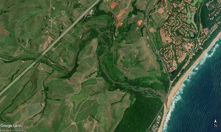
ANCHOR
                                                                                         e n v i ron me nta l

Ecological function and State of the Estuary

The uThongathi Estuary’s present ecological state (PES) is listed as “D” (Poor/Heavily modified) with a
recommended ecological category (REC) of “C”. Described as being small with a low assimilative
capacity, the estuary is sensitive to pollution, therefore, a significant impact within the estuary causing
a reduction in the ecological category is poor water quality, which in turn influences biotic components
of the system. The main sources of pollution include wastewater treatment works that discharge into
the system, discharge from the Tongaat Hulett Maidstone Sugar Mill, as well as urban runoff in the
river catchment which results in poor water quality for the inflowing water that reaches the head of
the estuary. It has been gazetted that the Target Ecological Category (TEC) for the uThongathi Estuary
should be a “B/C”. Achieving this mandated Ecological category (EC) will require the improvement of
a several of the individual components within the system, i.e. water quality and flow, birds, fish,
invertebrates). Similarly, the specific Resource Quality Objectives laid out for the estuary must be
upheld to ensure that the health of the estuary does not deteriorate and will need to be improved
upon, in order for the mandated category to be achieved.

Anthropogenic impacts have contributed to the decline of the overall shape and size of the estuary
relative to its historical extent. This is likely due to a reduction in freshwater inflows, coupled with
powerful wave action and increased sediment movement which can cause the mouth to become
restricted, reducing the tidal influence on the system and resulting in the development of a sandbar
closing the estuary mouth for varying periods of time. The estuary is classed as a “Large Temporarily
Closed estuary” with the mouth reported as open 84-87% of the time. The composition of the
sediment within the estuary has changes relative to the historical state as a result of changes in the
sediment input to the estuary due to agricultural development and sand mining operations.

Due to its small size the uThongathi estuary has little resilience to changes in freshwater quantity and
nutrient loading. Water quality declines dramatically during periods of low flow (reduced freshwater
inputs) and closed mouth conditions when the water residence time is increased. This is primarily
attributed to the accumulation of nutrients present in the effluent discharges from wastewater
treatment works, as well as toxins from urban, agricultural, and industrial runoff/discharges. Water
quality in the estuary has been described as “poor” as far back as 1978, although conditions improved
slightly with the upgrade of the wastewater treatment works. However, the overall water quality is
still considered poor with the system experiencing a build-up of nutrients and pathogens and a decline
in oxygen concentrations during periods of low water flow. In addition, several nutrient parameters
have been found in concentrations known to be toxic to aquatic life and fish kills have been recorded
to occur within the system.

The nutrient rich waters of the uThongathi Estuary support high levels of primary production and
microalgal growth and Phytoplankton biomass within the estuary ranges from 1-120 µgChla/l, varying
with the volume of freshwater inflow, the state of the mouth and the level of nutrients being
introduced by the Wastewater Treatment Works. The microalgal community within the Estuary has
been classed as having an ecological status of “E” or “Severely modified”.

An estimated 55% of the estuarine area has been lost to habitat transformation, with the majority of
the floodplain being altered by commercial and subsistence sugarcane farming. The remaining area
can generally be divided into four different vegetation types, namely (1) KwaZulu Natal coastal belt
grassland, (2) Northern Coastal forest and bushveld, (3) reeds and sedges and (4) invasive plant

                                                    ii
ANCHOR
                                                                                         e n v i ron me nta l

species. Smaller estuaries, like the uThongathi Estuary, which experience high pollution pressure and
eutrophication are vulnerable to the spread of invasive alien plant species and the diversity and
abundance of invasive alien plants within the uThongathi Estuary has increased over time with four
species of aquatic invasive species recorded. Additionally, four species of terrestrial invasive species
are present on the banks of the estuary. The macrophyte community within the Estuary has been
classed as having an ecological status of “D” or “Heavily modified”.

The uThongathi Estuary’s invertebrate and fish communities both have an ecological status of “E” or
“Severely modified”. Studies show that the estuary has a reduced diversity and abundance of
invertebrates and that this is an indication of a community exposed to moderate to heavy pollution,
along with low salinities and low oxygen levels. Similarly, the fish communities within the system have
been known to vary greatly from year to year, amongst seasons and even from month to month,
depending on the state of the mouth and water quality. It appears that the species diversity and
abundance of fish has decreased relative to community composition in the early 1980’s. This is likely
the result of loss of estuarine habitat, linked to the reduced saline intrusion (mouth condition and the
obstruction created by the causeway) and declines in the water quality within the system. Three
species of alien fish species are recorded as present in the estuary.

The uThongathi Estuary is considered to be of regional importance to the waterbird community of
Durban’s estuaries as well as being species rich and having high abundance relative to its size.
However, the recent assessment of the Estuary conducted for the 2018 NBA assigned the lowest
estuarine health score, “F” or “Critically modified” to the bird population. It is likely that the loss of
suitable fringing habitat (in which to roost and nest); changes to in-stream vegetation and the
associated loss in open sand and intertidal wading areas; as well as the low abundance and diversity
of invertebrates (a food source for birds) has resulted in the change in community composition and
the overall decline in bird abundances.

Ecosystem services

Defined as “the benefits that people obtain from ecosystems, including provisioning services (such as
food and water), regulating services (such as flood control), cultural services (such as recreational
benefits), and supporting services (such as nutrient cycling, carbon storage) that maintain the
conditions for life on Earth.” The list of ecosystem services provided by the uThongathi Estuary is
short, as the system is small and has already been subjected to anthropogenic impacts in the past.
Services provided include the provision of raw materials, the breakdown of waste and detoxifying of
pollutants, as well as very limited provision of refugia and nursery area, material and nutrient export
as well as limited tourism and recreational value.

Impacts or potential impacts to the Estuary

The estuary has been significantly modified and the ecological functioning and provision of ecosystem
services has declined. The 2018 National Biodiversity Assessment rates the cumulative pressure level
of the uThongathi Estuary as high, with pressures listed for the estuary including: pollution (very high);
habitat loss and alien fish (high); flow modification and invasive plant species (medium); low fishing
pressure, the presence of sand mining and the occurrence of unauthorised artificial breaching of the
mouth. Additionally, the physical impacts acting on the system include several main categories; (1)
the construction of a causeway across the upper reaches of the estuary; (2) high rates of sediment

                                                    iii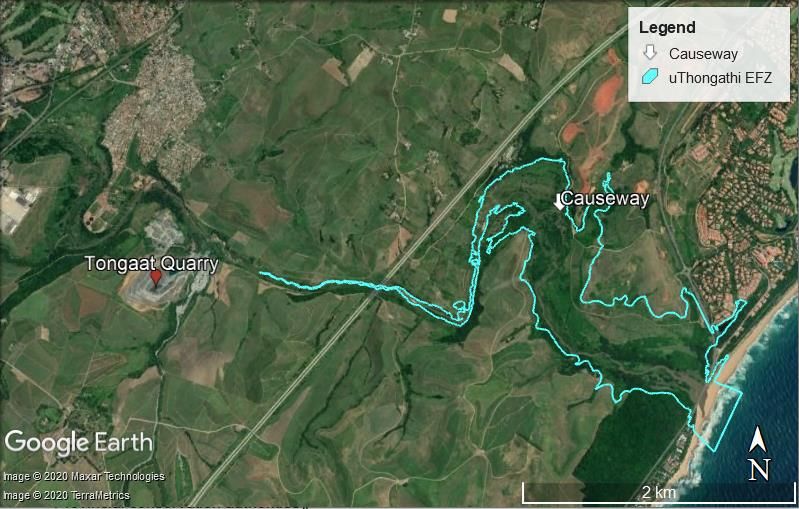
ANCHOR
                                                                                         e n v i ron me nta l

accumulation in the estuary during the last 30 odd years as a result of high erosion rates; (3) sand
mining impacts; (4) coastal access: the accessibility of the estuary to those who do not live in the direct
vicinity; (5) the proliferation in the estuary, riparian zone and floodplain by sugar cultivation and
invasive alien plants (6) the lack of adequate warning signs regarding the presence of crocodiles in the
system and (7) most significantly - the poor water quality within the estuary and impacts of
wastewater discharges.

Socio-economic context

The uThongathi Estuary falls within two municipalities, the eThekwini Metropolitan Municipality and
the KwaDukuza Local Municipality within the larger iLembe District Municipality. The majority of the
land surrounding the estuary consists of agricultural land (sugarcane cultivation), and to a lesser extent
industrial, commercial, residential areas and informal settlements (located to the north west of the
estuary) as well as some built up residential land on either side of the mouth. The majority of
economic activity is sugarcane farming and processing as well as a small proportion of sand mining.
The population is growing and consists largely of people under the age of 35 years.

Legislation

This section provides an overview of legislation and policy applicable to the management of estuaries
in South Africa and specifically to the uThongathi estuary. South Africa has an extensive legal
framework for governing the protection and sustainable use of the coastal marine environment, a
summary table of the relevant legislation is provided, as well as a description of provincial legislation
and local policies and strategies that relate to the uThongathi Estuary. Government’s response in
mitigating deterioration of South African estuaries is manifested in two pieces of key legislation,
namely the National Water Act (Act 36 of 1998) and National Environmental Management: Integrated
Coastal Management Act (Act 24 of 2008) (ICMA). Policy and legislation which affects estuaries
directly can be roughly divided into that affecting (1) estuarine resources planning and protection, (2)
enabling integration for estuarine management and (3) management of activities or uses in and
around the estuaries.

Opportunities and constraints for consideration in EMP

Given that the estuary lies on the border of three municipalities, the management of the system will
need to be appropriately divided between authorities within these municipalities, based on the area
in which management strategies need to be applied, or else be co-ordinated amongst all authorities
where strategies overlap, therefore requiring a fair amount of cooperative governance.

The poor water quality within the estuary, the occurrence of sewage spills and malfunctioning
infrastructure at the WWTW poses the most significant and severe risk to the uThongathi Estuary.
Unless the level of enrichment within the system is reduced all other attempts to improve the
condition of the estuary are likely to have minimal to no positive effect, simply allowing the estuary
to retain the current ecological state.

A comprehensive Environmental Management Programme (EMPr) has been developed for the Zimbali
Lakes and Golf Course Residential Development (construction for which began earlier this year) which
falls along, and within, a substantial portion of the northern border of the Estuarine Functional Zone,

                                                    iv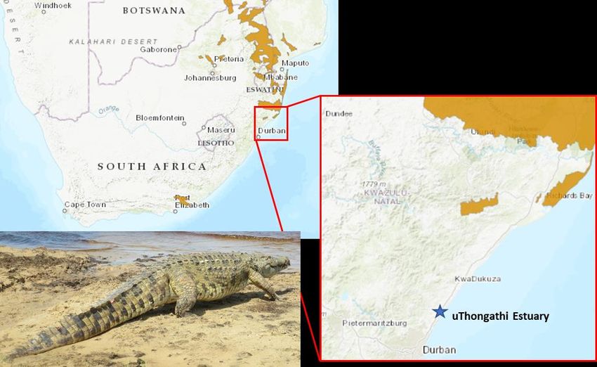
ANCHOR
                                                                                      e n v i ron me nta l

between the mouth and the N2 roadway. This programme includes an estuarine rehabilitation,
monitoring and management plan; a stormwater management plan, and a wetland management and
rehabilitation plan; which together address and will improve a number of the issues and threats
impacting the estuary. While the development does not encompass the entire estuarine area it does
account for roughly half of the total functional zone therefore substantially reducing the management
workload of the local authorities and creating a valuable opportunity to halve the responsibility while
increasing the overall impact of the Estuarine Management Plan. In addition, an Environmental
Control Office (ECO) was appointed to monitor activities for compliance with the provisions set out in
the EMPr.

Recommendation to address information gaps

With the exception of a recently published paper on the invasive aquatic plant species in the estuary
(Nunes et al. 2020), there has been very little research or data collection conducted in the system
over the last 10 years. Spatial and temporal replication of information is valuable for enabling
researchers to map the changes that occur within a system over time and how the system is
responding to human activities. A list of information identified as being needed to improve on future
Ecological Water Reserves studies for the uThongathi Estuary is provided.

What’s next

This Situation Assessment (as determined during a desktop study ) provides the background to the
current state and condition of the uThongathi Estuary and its biota, as well as highlighting the
deficiencies and necessities in terms of management that must be addressed, in order to maintain a
functional estuarine system. Next, the local authorities and the general public from the surrounding
communities will be consulted to gain their input and perspective on the potential issues, threats and
information gaps associated with the uThongathi Estuary. The revised situation assessment will then
serve as the basis and platform for the development of the Estuary Management Plan.

                                                  v
ANCHOR
                                                                                                                                                   e n v i ron me nta l

                                                    TABLE OF CONTENTS
EXECUTIVE SUMMARY ......................................................................................................................................I

TABLE OF CONTENTS...................................................................................................................................... VI

GLOSSARY .................................................................................................................................................... VIII

LIST OF ABBREVIATIONS ................................................................................................................................ IX

1       INTRODUCTION ....................................................................................................................................... 1

    1.1         BACKGROUND ........................................................................................................................................... 1
    1.2         PURPOSE AND STRUCTURE OF THE SITUATION ASSESSMENT ................................................................................ 2

2       CHATCHMENT CHARACTERISTICS ............................................................................................................ 3

    2.1         GEOLOGY AND GEOMORPHOLOGY ................................................................................................................. 3
    2.2         CLIMATE AND RUNOFF ................................................................................................................................ 4
    2.3         LAND-USE ................................................................................................................................................. 6

3       OVERVIEW OF ECOLOGICAL FUNCTION AND STATE OF ESTUARY ............................................................ 8

    3.1       ECOLOGICAL HEALTH STATUS ........................................................................................................................ 8
    3.2       ABIOTIC FUNCTION ................................................................................................................................... 10
       Hydrodynamics and sediment ...................................................................................................................... 10
       Water quality ............................................................................................................................................... 12
    3.3       BIOTIC FUNCTION ..................................................................................................................................... 15
       Microalgae ................................................................................................................................................... 15
       Vegetation ................................................................................................................................................... 16
       Invertebrates ................................................................................................................................................ 17
       Fish ............................................................................................................................................................... 18
       Birds ............................................................................................................................................................. 20

4       ECOSYSTEM SERVICES ........................................................................................................................... 22

    4.1     WHAT ARE ECOSYSTEM SERVICES? ............................................................................................................... 22
    4.2     GOODS AND SERVICES PROVIDED BY THE UTHONGATHI ESTUARY ....................................................................... 23
       Raw materials .............................................................................................................................................. 24
       Carbon sequestration ................................................................................................................................... 24
       Waste treatment .......................................................................................................................................... 24
       Refugia and nursery areas ........................................................................................................................... 25
       Export of materials and nutrients ................................................................................................................ 25
       Tourism and recreational value ................................................................................................................... 26

5       IMPACTS OR POTENTIAL IMPACTS TO ESTUARY .................................................................................... 26

        Causeway ..................................................................................................................................................... 26
        Sedimentation within the estuary ................................................................................................................ 27
        Sand mining ................................................................................................................................................. 27
        Alterations to floodplain and Invasive/Alien species ................................................................................... 27
        Coastal access .............................................................................................................................................. 27
        Presence of crocodiles within the estuary .................................................................................................... 28
        Water quality and wastewater discharges .................................................................................................. 29

6       OVERVIEW OF SOCIO-ECONOMIC CONTEXT .......................................................................................... 30

                                                                                     vi
ANCHOR
e n v i ron me nta l
6.1 DEMOGRAPHICS....................................................................................................................................... 30
6.2 ECONOMIC PROFILE .................................................................................................................................. 31
6.3 SOCIAL CONSIDERATIONS ........................................................................................................................... 31
7 LEGISLATIVE INSTRUMENTS AND RELATED STRATEGIES/PROGRAMMES .............................................. 32
7.1 LEGAL FRAMEWORK APPLICABLE TO ESTUARINE MANAGEMENT ......................................................................... 32
7.2 MANAGEMENT STRATEGIES/PLANS RELEVANT TO THE ESTUARY ......................................................................... 35
7.3 EXISTING BY-LAWS ................................................................................................................................... 37
7.4 EXISTING MONITORING PROGRAMMES ......................................................................................................... 38
8 OPPORTUNITIES AND CONSTRAINTS FOR CONSIDERATION IN EMP ...................................................... 38
8.1 CONSTRAINTS .......................................................................................................................................... 38
8.2 OPPORTUNITIES ....................................................................................................................................... 40
9 RECOMMENDATIONS TO ADDRESS MAJOR INFORMATION GAPS ......................................................... 41
10 WHAT’S NEXT ........................................................................................................................................ 42
11 REFERENCES .......................................................................................................................................... 43
12 APPENDICES .......................................................................................................................................... 48
12.1 APPENDIX 1 – DESCRIPTION OF A PERCHED ESTUARY ....................................................................................... 48
12.2 APPENDIX 2 – UTHONGATHI RQOS (DWS 2015B) ....................................................................................... 49
12.3 APPENDIX 3 – WATER QUALITY DATA ........................................................................................................... 51
viiANCHOR
e n v i ron me nta l
GLOSSARY
Abiotic Physical rather than biological; not derived from living organisms.
Aeolian Relating to or arising from the action of the wind.
Alien A species that occurs outside of its natural range and dispersal potential.
Biotic Relating to living organisms.
Pertaining to the environment inhabited by organisms living on or in the bottom of a
Benthic
water body.
Biodiversity The variety of plant and animal life in a particular habitat.
Catchment area The area from which rainfall flows/drains into the estuary.
In ecology, a community is a group or association of populations of two or more
Community
different species occupying the same geographical area and in a particular time.
A process by which a body of water becomes overly enriched with minerals and
Eutrophication nutrients which induce excessive growth of algae. This process may result in oxygen
depletion of the water body after the bacterial degradation of the algae
Extralimital Situated, occurring, or originating from outside a particular region/estuary.
Broad and relatively flat area on either side of a stream, river or estuary that are
Floodplain
inundated by water during floods.
Head (of estuary) The upstream part of the system where freshwater enters.
Indigenous Species within the limits of their native range (Synonyms: native).
Species whose natural range occurs outside of South Africa and which were
Invasive alien species transported to their current location by humans; where they are able to reproduce,
spread and typically cause negative ecological impact.
A change to the existing environment, either adverse or beneficial, that is directly or
Impact
indirectly due to the development of the project and its associated activities.
Invertebrate An animal without a backbone (e.g. a prawn, crab, or worm).
Legislation Laws, legal requirements or the process of making or enacting laws.
Macrofauna Animals larger than 0.5 mm.
Macrophytes Aquatic plants large enough to be seen by the naked eye.
Microscopic algae, typically found in freshwater and marine systems, living in both the
Microalgae water column and sediment. They are unicellular species which exist individually, or in
chains or group.
A measure or scale used to quantify how acidic or basic (alkaline) a water-based
pH
solution is.
Microscopic organisms that live in aquatic systems that are able to photosynthesize to
Phytoplankton
feed themselves.
The period of time during which a body of water remains stationary or trapped within a
Residence time
specific region of the system.
Productive zone within an estuary where marine and freshwater meets, salinity is less
River Estuary Interface than that of sea water and organic deposition due to reduced current speeds and
flocculation occurs and is retained.
Heterotrophic plankton i.e. plankton that cannot manufacture its own food by carbon
Zooplankton fixation and therefore derives its intake of nutrition from other sources of organic
carbon, mainly plant or animal matter.
viiiANCHOR
e n v i ron me nta l
LIST OF ABBREVIATIONS
Anchor Anchor Environmental Consultants
CFU Colony Forming Units
CMP Coastal Management Programme
EC Ecological Category
ECO Environmental Control Officer
EDTEA Economic Development, Tourism and Environmental Affairs
EFZ Estuarine Functional Zone
EIA Environmental Impact Assessment
EMP Estuarine Management Plan
Environmental Management Plan
EMPr The Environmental Management Programme
EWR Ecological Water Requirement
DEAT Department of Environmental Affairs and Tourism
DEADP Department of Environmental Affairs and Development Planning
DoT Department of Transport
DPLG Department of Provincial and Local Government
DMR Department of Mineral Resources
DWA Department of Water Affairs (Change after 2008)
DWAF Department of Water Affairs and Forestry
DWS Department of Water Affairs and Sanitation (Change after May 2014)
IAAP Invasive Alien Aquatic Plants
ICLEI SA International Council for Local Environmental Initiatives African Secretariat
ICMA National Environmental Management: Integrated Coastal Management Act (Act No. 24 of
2008), as amended by National Environmental Management: Integrated Coastal Management
Amendment Act (Act No. 36 of 2014)
IDP Integrated Development Plan
LAB Local Action for Biodiversity
MAR Mean Annual Runoff
MCM Marine and Coastal Management
MLRA Marine Living Resources Act (Act No. 18 of 1998, amended 2000)
MPA Marine Protected Area
MSL Mean Sea Level
NBA National Biodiversity Assessment
NCMP National Coastal Management Programme
NEMA National Environmental Management Act (Act No. 107 of 1998)
NEsMP National Estuarine Monitoring Programme
NWRS National Water Resource Strategy
nMAR Natural Mean Annual Runoff
PES Present Ecological State
pMAR Present Mean Annual Runoff
Protocol National Estuarine Management Protocol
ixANCHOR
e n v i ron me nta l
REC Recommended Ecological Category
REI River-Estuary Interface
ROD Record of Decision
RQO Resource Quality Objective
SPLUMA Spatial Planning and Land-use Management Act
TEC Target Ecological Category
WMA Water Management Area
WSAP Wetlands South Africa Programme
WWTW Wastewater Treatment Works
xuThongathi Estuary Situation Assessment Report
1 INTRODUCTION
1.1 Background
With the implementation of the Provincial Coastal Management Programme (adopted by the MEC in
September 2019) that includes strategies and plans for the effective and co-operative management
of the coastal zone, the KwaZulu-Natal (KZN) Department of Economic Development, Tourism and
Environmental Affairs has prioritised the better management of estuaries in the province. With the
aim to mitigate the deterioration of KZN regional estuaries, an estuary prioritisation process was
undertaken and the uThongathi Estuary was prioritised for the development of an Estuary
Management Plan (EMP).
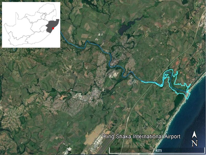
Located within the province of KwaZulu Natal on the east coast of South Africa, the uThongathi Estuary
is approximately 35 km north of Durban in the vicinity of the King Shaka International Airport and lies
on the boundary between the eThekwini Metropolitan Municipality and iLembe District Municipalities
(Figure 1) (Forbes & Demetriades 2009). The estuary is just under 6 km in length from the mouth,
which leads into the Indian Ocean, to its head, and the total estuarine area is approximately 37 ha
(Adams and Van Niekerk 2020). The newly revised estuarine classifications for South Africa, define a
“Large Temporarily Closed estuary” as one in which the mouth of the system is open to the sea more
the 50% of the time (Van Niekerk et al. 2019a, 2020). The uThongathi Estuary mouth has been
reported to be open between 84-87% of the time (DWA 2013, Nunes et al. 2020).
Figure 1. Location of the Tongati River and the uThongathi Estuary and estuarine area within the province of
KwaZulu Natal, South Africa.
ANCHOR
e n v i ron me nta l
1uThongathi Estuary Situation Assessment Report
The uThongathi town and industries lie to the west/north west of the system with urban areas starting
less than one kilometre from the head of the estuary. Additionally, there are residential areas to the
north and south of the estuary mouth and the construction of a new residential development and golf
estate has begun along the northern banks of the middle to lower reaches of the system. The vast
majority of land surrounding the estuary is under agricultural development in the form of sugar cane,
although there is a significant area of coastal forest on either side of the estuary mouth which is
important from a biodiversity perspective and also provides an aesthetically pleasing component to
the estuary and its surrounds (Forbes & Demetriades 2009).
Described as being small with a low assimilative capacity, the estuary is sensitive to pollution and has
a long history of anthropogenic change. The main sources of pollution are listed as including
wastewater treatment works that discharge into the system, Tongaat Hulett Maidstone Sugar Mill, as
well as urban and agricultural runoff in the river catchment which results in poor water quality for the
inflowing water that reaches the head of the estuary. Other threats to the system include alien
invasive species (fish and vegetation), sand mining, bait collection, fish kills associated with low water
quality within the estuary, and habitat loss (Van Niekerk et al. 2019e).
The estuary has been classified as an endangered system of high biodiversity importance in the recent
National Biodiversity assessment, however, it has no specific formal protection status and the present
ecological state (PES) is listed as D - “Poor” or “Heavily modified” (DWS 2015a,b, Van Niekerk et al.
2019b,c,d). Numerous restoration measures, designed to improve the estuary’s ecological condition
and mitigate anthropogenic pressures, were put forward in the most recent national biodiversity
assessment and include the removal of alien vegetation and rehabilitation of the riparian vegetation
and wetland; the eradication of alien fish; protection from mining impact and the reduction and
monitoring of wastewater (Van Niekerk et al. 2019f) and highlight the need for a management plan
which assigns the responsibility of these and other activities to the appropriate parties.
1.2 Purpose and structure of the Situation Assessment
The purpose of Estuary Management Plans (EMP), as stated in the protocol and development
guidelines “is to provide the mechanism that will enable coordination and alignment of management
activities across sectors, underpinned by a shared vision – that is integrative estuarine management.”
(DEA 2015).
The purpose of the Situation Assessment is to reflect on the current condition of the system and status
of estuarine management for the specific estuary. The document therefore provides a framework of
relevant and available information that enables the development of the Estuarine Management Plan
as well as highlighting any knowledge gaps that may impact the effective implementation of the EMP.
The following components are included in the Situation Assessment Report:
• A biogeographical description of the uThongathi Estuary and comprehensive assessment of the
structure (abiotic and biotic), functioning and state of the estuary.
• The reserve determination for the uThongathi Estuary is available in the form of an intermediate
level Ecological Water Reserve study (DWAF 2007), as well as in the National Biodiversity
ANCHOR
e n v i ron me nta l
2uThongathi Estuary Situation Assessment Report
Assessments and ecological reserve studies for the greater water management area. These are
summarized in Section 3.1.
• Identification of the goods and services and/or human use activities and their impacts or potential
impacts on the present ecological state.
• The geographic and socio-economic context of the estuary, including dependence of local
communities on the estuary. Opportunities and Constraints within the ecological system
considering the current and recommended ecological state and limits of acceptable change
where possible.
• The legislative instruments currently applicable to the effective management of the uThongathi
Estuary – including existing and planned management strategies or plans (catchment
management strategies, Integrated Development Plans, Spatial Development Frameworks,
Coastal Management Programmes, Disaster Management Plans, Contingency Plans and Mouth
Management Plans are examples).
• Identification of information gaps pertaining to the estuary.
2 CHATCHMENT CHARACTERISTICS
2.1 Geology and geomorphology
The uThongathi Estuary and its surrounds are located on several different geology types including
Alluvium along the watercourse, Berea Formation and leached Berea, Karoo dolerite, and Vryheid
shale (GroundTruth 2018). The latter is common along the edges of the watercourse and due to its
greater clay content, areas underlain by this formation commonly contain more wetland than the
other formations mentioned (GroundTruth 2018). Anthropogenic impacts acting on the estuary
include commercial sugar cane farming since 1848; residential development since 1945; the
construction of two bridges; (1) the M4 bridge located ±100 m from the mouth of the estuary
(constructed in 1960) and (2) the N2 Bridge just short of 5 km upstream of the mouth; as well as the
construction of a causeway 2.5 km from the mouth (constructed in 1989, Forbes & Demetriades 2009,
Nunes et al. 2020).
In order to facilitate the cultivation of sugarcane, which prefers drier earth than wetland areas, much
of the landscape surrounding the estuary was altered to include a number of ridge-and-furrow
networks, the construction of which has altered the functionality of the floodplain. This disrupted the
water table, preventing diffuse waterflow and ultimately led to a reduction in the provision of
important goods and serves provided by the floodplain for the estuary (MER 2008). Similarly, the
construction of the bridges and causeway altered flow within the estuary.
Strong wave action associated with its location on the east coast of South Africa, as well as high levels
of sediment availability has resulted in the development of a perched system i.e. a system with a raised
berm and a resulting water level that is higher than that of the adjacent sea level (Copper 2001, See
appendix 1 in section 12.1). Additionally, the estuary has a small, constricted mouth which only allows
for reduced tidal intrusion (Figure 2). The presence of a causeway across the estuary, located 2.5 km
from mouth, creates a barrier which further limits the penetration of saline water beyond this point.
ANCHOR
e n v i ron me nta l
3uThongathi Estuary Situation Assessment Report
Figure 2. Photo taken in December 2020 showing the small, restricted mouth of the uThongathi estuary as well as
the perched nature of the system (water level in the estuary higher than that of the adjacent sea).
2.2 Climate and runoff
The KwaZulu Natal region experiences a summer rainfall season, predominantly receiving rainfall
between October and April, with high rainfall events typical in the months of December and February.
Associated with this seasonal rainfall the estuary experiences low river inflow during winter
(approximately 1.2 m3.s-1) and high river inflow during summer (approximately 2.2 m3.s-1). The Tongati
River catchment consists of two quaternary catchments (U30C and U30D) with a total catchment area
of 423 km2 and an estimated Natural Mean Annual runoff (nMAR) of 70.79 million m3 per year (Figure
3). By contrast, the present Mean Annual Runoff is estimated at 79.2 million m3 per year due to
additional wastewater inputs (DWS 2015a, b). Two dams (Figure 4), the Dudley Pringle (2.31 x10⁶ m3)
and the smaller Syphon dam (0.35 x 10⁶ m3) are located in the Wewe tributary which meets the
Tongati River approximately 5 km above the upper limit of the estuary (Begg 1978, Forbes &
Demetriades 2009). Any reduction in MAR as a result of water diverted to these dams is compensated
for by the addition of water from the Tongaat Central Wastewater Treatment Works (WWTW), Frasers
WWTW and the Hulett Maidstone Sugar Mill, which are both located downstream of the tributary
leading to the dams (Figure 4) (Nunes et al. 2020).
ANCHOR
e n v i ron me nta l
4uThongathi Estuary Situation Assessment Report
Figure 3. Tongati River Catchment and Estuary Functional Zone (EFZ).
The promotion of wise use of estuarine resources and the protection and conservation of estuarine
biodiversity requires not only the protection of estuarine habitat and biota, but also the protection of
the physical processes/functions that sustain ecological and evolutionary processes. Therefore, to
ensure the present and future health of estuaries, it is necessary to define the ‘space’ within which
estuaries function over longer time scales – these areas are known as the ‘Estuarine Functional Zone’
(EFZ, Van Niekerk et al. 2012, 2013).
The National biodiversity Assessment (Van Niekerk et al. 2019) defines the EFZ as “the area that not
only encapsulates the estuary waterbody, but also the supporting physical and biological processes
and habitats necessary for estuarine function and health. It includes all dynamic areas influenced by
long-term estuarine sedimentary processes, i.e. sediment stored or eroded during floods, changes in
channel configuration, aeolian transport processes, and changes due to coastal storms. It also
encompasses all the multiple ecotones of floodplain and estuarine vegetation that contribute detritus
(food source) and provide refuge from strong currents during high flow events.” The extent of the
uThongathi Estuary’s EFZ as delineated in the recent NBA can be seen in Figure 4 and Figure 7.
Although in most estuaries the 5m contour was still used to define the functional zone, for some small,
incised estuaries (i.e. 0 m, 5 m and 10 m contour in close proximity to each other such as uThongathi
Estuary) with relatively high river flow, a combination of the 5m and 10m contour, were used as the
default to accommodate mapping uncertainty (Van Niekerk et al. 2019).
ANCHOR
e n v i ron me nta l
5uThongathi Estuary Situation Assessment Report
Figure 4. uThongathi Estuary with local roads, associated dams and landmarks, DWS water quality monitoring
stations and the extent of the Estuarine Functional Zone (EFZ) as defined in the latest National Biodiversity
Assessment (Van Niekerk et al. 2019). Source: Google Earth.
2.3 Land-use
The river section in the upper quaternary catchment (U30C) is 36 km in extent (Figure 3). The upper
reaches (27%) of the river, as well as along the remaining extent of the southern side of the river are
rural and nearly exclusively comprised of scattered households with evidence of informal agriculture
in the form of farming and live-stock grazing. Between the scattered households and the remaining
area, the dominant land-use is open terrain or natural vegetation (DWS 2015c).
The lower quaternary catchment (U30D) is characterised by low-density settlements and rural
settlements as well as the uThongathi town and industries. The area is predominantly a sugar cane
farming area with most of the landscape covered with dry land sugar cane plantations (DWS 2015c).
In built up areas there is some commercial, community, industrial and mining activity.
The majority of the land surrounding the uThongathi Estuary as well as within the EFZ is under
cultivation in the form of sugarcane farming, which was first started in 1848. Additional anthropogenic
impacts acting on the estuary include residential development since 1945, the construction of two
bridges (1) the M4 bridge located ±100 m from the mouth of the estuary and (2) the N2 Bridge just
short of 5 km upstream of the mouth, and the construction of a causeway 2.5 km from the mouth
(Forbes & Demetriades 2009, Nunes et al. 2020). Major land-use changes that occurred within the
ANCHOR
e n v i ron me nta l
6uThongathi Estuary Situation Assessment Report
catchment over time can be seen in Figure 5, which include the development of Wastewater
Treatment Works (WWTW) that discharge effluent into the system.
Figure 5. Timeline showing the major catchment land-use changes within the Tongati River Catchment (amended
from DWAF 2007 and Nunes et al. 2020).
Aside from the sugarcane cultivation and some built up urban areas the land surrounding the estuary
includes two main vegetation types (KwaZulu-Natal coastal belt grasslands and Northern coastal forest
and bushland), with a small portion of reeds and sedges located close to the estuary mouth. A fair
portion of the EFZ is also categorised as being degraded land, as well as portions of the system where
stands of Invasive Alien Aquatic Plants (IAAPs) are present (Figure 6). It is noteworthy that ground
was broken earlier this year for the Zimbali Lakes and Golf Course Residential Development, this
property is located along and within a substantial portion of the northern borders of the EFZ, between
the mouth and the N2 roadway. This development will result in the demolishment of a large portion
of sugar cane, the removal of alien vegetation and the rehabilitation of degraded wetland areas (see
section 8).
ANCHOR
e n v i ron me nta l
7uThongathi Estuary Situation Assessment Report
Figure 6. Primary landcover/vegetation types surrounding the uThongathi Estuary in 2017. IAAPS – Invasive Alien
Aquatic Plants (Amended from Nunes et al. 2020).
3 OVERVIEW OF ECOLOGICAL FUNCTION AND STATE OF
ESTUARY
3.1 Ecological health status
The National Water Act of 1998 requires the implementation of 'Resource Directed Measures' (RDM)
for the optimal use of our country’s water resources while minimising ecological damage. The main
focus of a RDM is the determination of the 'Reserve', which is the water quality and quantity required
for the protection of both basic human needs and the needs of aquatic systems. The ‘Ecological
Reserve’ is the quality and quantity of water required for a specific aquatic system (e.g. river reach,
wetland, estuary) to maintain a desired level of structure and function, or quality. The desired quality
of the water resource is defined by its ‘Ecological Category’ which is assigned a letter on a health scale
of A to F (Table 1). While scientists can make recommendations for this category the “Recommended
Ecological Category” (REC), the final decision will be based on ecological, social and economic criteria
in a participative process called the National Water Resource Classification System’s Classification
Process (Dollar et al. 2010; gazetted in 2010). Ultimately the Department of Water Affairs {now
Department of Human Settlement, Water and Sanitation (DHSWS)} will be responsible for the
Classification of all significant water resources in the country, including estuaries, and these decisions
will be re-evaluated at intervals (Turpie et al. 2012).
ANCHOR
e n v i ron me nta l
8uThongathi Estuary Situation Assessment Report
Table 1. Ecological categories for South African estuaries, the uThongathi Estuary has been classified as a D status.
(DWA 2012, Van Niekerk et al. 2019).
Condition Present
General Description
(% of pristine) ecological state
Unmodified, approximates natural condition: The natural abiotic processes should
not be modified. The characteristic of the resources should be determined by
≥91% A unmodified natural disturbance regimes. There should be no human induced risks
to the abiotic and biotic processes and function.
Near natural with few modifications: A small change in the natural habitats and
76--90 B biota may have taken place, but the ecosystem functions are essentially unchanged
Moderately modified: A loss and change of the natural habitat and biota have
61-75 C occurred, but the basic ecosystem functions are still predominantly unchanged.
Heavily modified: A large shift in natural processes and ecosystem functions
41-61 D and/or loss of habitat, biota have occurred.
Severely modified: The loss of natural habitat, biota and basic ecosystem functions
21-41 E is extensive.
Critically Modified: Modifications have reached a critical level and the system has
been modified completely with an almost complete loss of natural abiotic
≤20 F processes and associated biota. In the worst instances the basic ecosystem
functions have been destroyed and the changes are irreversible.
In June 2007, an Intermediate level Ecological Reserve Determination or Ecological Water
Requirement (EWR) was prepared for the uThongathi Estuary (DWAF 2007). The estuary has since
additionally been assessed during a classification of Water Resources and Resource Quality Objectives
(RQO) study for the Mvoti to Umzimkulu Water Management Area (DWS 2015a,b,c), as well as for the
2011 and 2018 National Biodiversity Assessment (NBA) (Van Niekerk et al. 2012, 2019).
The Estuarine Health Index (EHI) applied in Ecological Water Requirement (EWR) studies include a
number of variables/categories laid out in DWA (2008) (Table 2). For each category, the conditions
are estimated as a percentage (0 – 100%) of pristine health. Scores are then weighted and aggregated
so that the final score reflects the present holistic health of the estuary as a percentage of the pristine
state (DWS 2015a).
The uThongathi Estuary’s present ecological state (PES) is listed as “D” (Poor/Heavily modified) with a
recommended ecological category (REC) of “C” (DWS 2015a, b, Van Niekerk et al. 2019d). Described
as being small with a low assimilative capacity, the estuary is sensitive to pollution, therefore, a
significant impact within the estuary causing a reduction in the ecological category is poor water
quality, which in turn influences biotic components of the system. The main sources of pollution
include wastewater treatment works that discharge into the system, as well as urban runoff in the
river catchment which results in poor water quality for the inflowing water that reaches the head of
the estuary (Van Niekerk et al. 2019e).
A breakdown of the individual components assessed, and the scores given to each within the
uThongathi Estuary is provided below and shows that despite the overall ecological category being a
“D” several of the individual components have lower scores and are “severely” or “critically modified”
(Table 2).
ANCHOR
e n v i ron me nta l
9uThongathi Estuary Situation Assessment Report
The estuary has been classified as an endangered system with a high biodiversity importance rating in
the recent National Biodiversity assessment, however, the estuary has no specific formal protection
status (Van Niekerk et al. 2019b,c,d). In addition, it has been gazetted that the Target Ecological
Category (TEC) for the uThongathi Estuary should be a “B/C” (Government Gazette 41306, Notice No.
1386 of 8 December 2017). This category represents an overall health score that ranges between
roughly 67-83% of pristine estuarine health when the current state is between 40-60%. Achieving this
mandated Ecological category (EC) will require the improvement of a several of the individual
components.
Table 2. Ecological categories associated with individual components of the estuary
NBA 2018 Condition Status
Present Ecological State (2018) D Microalgae E
Hydrology C Macrophytes D
Hydrodynamics B Invertebrates E
Water Quality E Fish E
Physical habitat D Birds F
Associated with the EC of and estuary are specific Resource Quality Objectives (RQOs), these are
numerical as well as descriptive statements regarding the biological, chemical and physical attributes
that characterise a resource (estuary in this case) for the level of protection defined by its Class. The
National Water Resource Strategy (NWRS) therefore stipulates that “Resource Quality Objectives
might describe, among other things, the quantity, pattern and timing of flow; water quality; the
character and condition of habitat, and the characteristics and condition of the aquatic biota” (DWS
2015a). Although not officially gazetted, more in depth RQOs have been developed for the uThongathi
Estuary and are shown in section 12.2 – Appendix 2. These RQOs must be upheld to ensure that the
health of the estuary does not deteriorate and will need to be improved upon, in order for the
mandated REC to be achieved.
3.2 Abiotic function
Hydrodynamics and sediment
The overall shape and size of the estuary has declined relative to its historical extent (Begg 1984) likely
due to a reduction in freshwater inflows, coupled with powerful wave action and increased sediment
movement which can cause the mouth to become restricted, reducing the tidal influence on the
system and resulting in the development of a sandbar closing the estuary mouth for varying periods
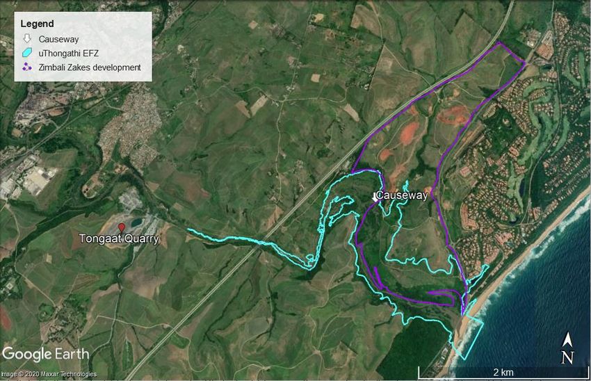
of time (Van Niekerk et al. 2019, Adams et al. 2020). In addition, the placement of a causeway 2.5 km
from the mouth (constructed in 1989), creates an artificial estuary head as saline water cannot
penetrate beyond this obstacle (Figure 7). These anthropogenic impacts have resulted in the overall
estuary area being reduced from approximately 150 ha under reference (historical natural) to 20 ha
when assessed in 2008 (MER 2008, Forbes & Demetriades 2009). More recently, the system’s
estuarine area is estimated to be 37 ha (Adams and Van Niekerk 2020) and the EFZ, as defined in the
ANCHOR
e n v i ron me nta l
10uThongathi Estuary Situation Assessment Report
2018 NBA, reaches beyond the causeway, stretching to 6 km from the mouth, thus including important
vegetation and floodplain areas that fall beyond the reach of saline water (Figure 7).
Figure 7. Location of the causeway, the Sand mining quarry and the Estuarine Functional Zone (EFZ) of the
uThongathi Estuary as defined in the latest National Biodiversity Assessment (Van Niekerk et al. 2019).
Source: Google Earth and CSIR 2018.
Begg (1984) described the uThongathi Estuary sandbar as 150 m in length, 30-70 m wide and reaching
a height of 5 m above mean sea level (MSL), however, by 2007 the width of the sandbar increased
substantially due to a large sea storm in March of that year, which deposited large volumes of sand in
the mouth (Forbes and Demetriades 2009).
According to the new estuary classification developed by Van Niekerk et al. (2019a, 2020) the estuary
is classed as a “Large Temporarily Closed estuary” (an estuary in which the mouth is open to the sea
>50% of the time). Specifically, the uThongathi Estuary mouth has been reported as open 84% of the
time (DWA 2013). More recently, Nunes et al. (2020) identified four different mouth states for the
uThongathi Estuary, showing that for the period 2005-2013 open mouth conditions dominated 46%
of the time, semi-closed 41%, closed but overtopping 10% and closed conditions only 3% of the time
(Table 3).
ANCHOR
e n v i ron me nta l
11You can also read