Hook Rural Tourism Ltd - Biodiversity Feasibility Study
←
→
Page content transcription
If your browser does not render page correctly, please read the page content below
Hook Rural Tourism Ltd
 Biodiversity Feasibility Study

   Clumps of Tall Sea-lavender (Limonium procerum) (foreground) sporting small, lilac-blue
   flowers, growing on bare, outcropping limestone rock at Hook Head. (Photo: Jim Hurley)

                                           -o0o-

                      ― Report dated 12 January 2021 ―

    Report compiled by Jim Hurley
SWC Promotions Hook Rural Tourism Ltd :: Biodiversity Feasibility Study Page 2 of 80.
― Summary of this report ―
     1. Hook Rural Tourism Limited is a community-based organisation on the
         Hook Peninsula in south-west County Wexford. The organisation has
         been in existence for over 50 years and is a not-for-profit enterprise.
         Among the very many different aspects of its work, it promotes the Hook
         Peninsula as a tourist destination in a manner that protects the area’s
         unspoiled coastal landscape and significant heritage resource values.

     2. The project area, that is, the location ‘the Hook Peninsula’ as promoted
         by Hook Rural Tourism Limited, is shown below (Figure 1). On its
         northern side the area extends to the town of New Ross. On its eastern
         side it includes the village of Wellingtonbridge and the Keeragh Islands.
         To the south and west the area is bounded by the Celtic Sea, Waterford
         Harbour estuary, and the River Barrow that flows through New Ross.
         The distance by road from Hook Head to New Ross is nearly 40km and
         the extent of the project area is 400km2 approximately. All of the project
         area used to be in the New Ross Municipal District but since the 2018
         revision of electoral areas, the eastern edge of the project area is now
         in the Rosslare Municipal District.

                                               Keeragh
                                               Islands

                        Hook Head

       Figure 1. Location of the project area (red fill).
                 (Base map source: screen snip from https://maps.wexford.ie/imaps/. Ordnance
                                  Survey Ireland Permit No MP 0002120. © Ordnance Survey
                                                               Ireland/Government of Ireland)

SWC Promotions            Hook Rural Tourism Ltd :: Biodiversity Feasibility Study   Page 3 of 80.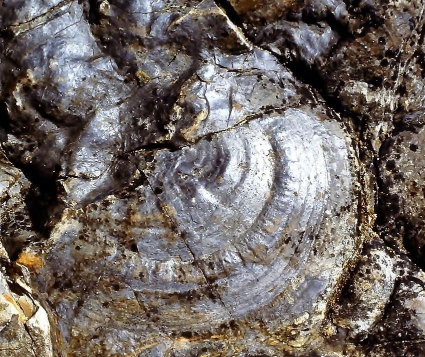
3. It has always been an objective of Hook Rural Tourism Limited to
         increase environmental awareness and understanding of the natural
         heritage resource values of the peninsula by disseminating information
         on the biodiversity of the area in a variety of media to local residents,
         the public and tourists visiting the Hook Peninsula.

     4. In 2020 that generic, long-standing objective crystalised into the
         ‘Biodiversity Project’, a focused attempt to promote the biodiversity of
         the Hook Peninsula. As a starting point, this feasibility study was
         commissioned.

     5. This ‘Biodiversity Feasibility Study’ seeks to identify and list the natural
         heritage resource values of the project area, to explore how best these
         values can be developed for local people and visitors alike to
         experience and enjoy, and to make recommendations regarding the
         steps the Biodiversity Project might take to achieve its overarching
         aims.

     6. During November 2020, a draft report was circulated to the board and
         members of Hook Rural Tourism Limited, tourism stakeholders, those
         involved in promoting biodiversity in the project area, and other
         interested parties inviting comment before 31 December 2020. The draft
         report was also posted online (https://hookpeninsula.com/biodiversity/)
         and public notice of its existence was flagged in the local press (New
         Ross Standard, December 2020 issues dated 1st, pages 50-51; 8th,
         pages 59-60; 15th, pages 68-69, 22nd pages 77-78, and 29th pages
         67-68).

     7. This final report incorporates comment and feedback received regarding
         the draft report, together with fleshing-out, corrections, amendments,
         updating and additional photographs.

                                                 -o0o-

SWC Promotions           Hook Rural Tourism Ltd :: Biodiversity Feasibility Study   Page 4 of 80.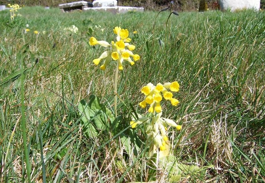
― Table of Contents ―

1. Introduction ______________________________________ 11
        Background ______________________________________________________ 11
        Terms of reference ________________________________________________ 12

2. Natural heritage resources __________________________ 13
        Introduction ______________________________________________________ 13
3. Natura 2000 sites __________________________________ 14
        Introduction ______________________________________________________ 14
        Bannow Bay (SAC IE000697) _______________________________________ 16
        Bannow Bay (SPA IE004033) _______________________________________ 17
        Hook Head (SAC IE000764) ________________________________________ 19
        Keeragh Islands (SPA IE004118) ___________________________________ 20
        River Barrow and River Nore (SAC IE002162)________________________ 21
4. Bannow Bay Ramsar site ___________________________ 23
5. Proposed Natural Heritage Areas _____________________ 24
        Introduction ______________________________________________________ 24
        Ballyhack (pNHA No 000695) _______________________________________ 25
        Ballykelly Marsh (pNHA No 000744) ________________________________ 25
        Boley Fen (pNHA No 000699)_______________________________________ 26
        Duncannon Sandhills (pNHA No 001738) ____________________________ 26
        Oaklands Wood (pNHA No 000774) _________________________________ 27
        Tintern Abbey (pNHA No 000711) ___________________________________ 27

6. Fossil sites _______________________________________ 28
7. Areas of specific protection _________________________ 30
        Natura 2000 sites _________________________________________________ 30
        Proposed NHAs ___________________________________________________ 30
        Bannow Bay Ramsar site __________________________________________ 31
        Fossil sites _______________________________________________________ 32

8. Areas of special interest ____________________________ 33
        Introduction ______________________________________________________ 33
        Habitats of special interest_________________________________________ 33
        Species of special interest _________________________________________ 40
9. Existing activities __________________________________ 44

SWC Promotions        Hook Rural Tourism Ltd :: Biodiversity Feasibility Study   Page 5 of 80.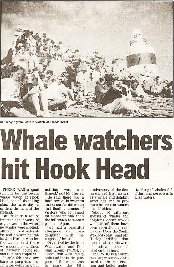
10. Birdwatching ____________________________________ 45
        Introduction ______________________________________________________ 45
        Bannow Bay ______________________________________________________ 45
        Hook Head _______________________________________________________ 46
        Arthurstown ______________________________________________________ 47

11. Whale watching __________________________________ 48
12. Nature walks _____________________________________ 50
13. Vehicle-based experiences _________________________ 53
14. Water-based experiences __________________________ 55
15. Areas of general interest ___________________________ 56
        Introduction ______________________________________________________ 56
        Existing attractions _______________________________________________ 57

16. Existing biodiversity plans _________________________ 58
        Introduction ______________________________________________________ 58
        Ireland’s Biodiversity Action Plan __________________________________ 58
        Wexford’s Biodiversity Action Plan _________________________________ 58
17. Summaries of some submissions ___________________ 59
        National Parks and Wildlife Service _________________________________ 59
        Fáilte Ireland______________________________________________________ 59
        Wexford County Council ___________________________________________ 59

18. Conclusions _____________________________________ 60
19. Guiding principles ________________________________ 61
20. Recommendations ________________________________ 62
21. Cost benefit analysis ______________________________ 64
22. Appendices______________________________________ 65
        Appendix 1: The Hook Peninsula ___________________________________ 65
        Appendix 2: Hook Tourism Biodiversity Project Brief ________________ 66
        Appendix 3: County Wexford Tourism Strategy______________________ 67
        Appendix 4: Draft Wexford County Development Plan _______________ 69
        Appendix 5: Comments from the DAU/NPWS ________________________ 70
        Appendix 6: Comments from Fáilte Ireland __________________________ 73
        Appendix 7: Comments from Wexford Co Council ___________________ 75

23. References and literature cited _____________________ 77

SWC Promotions        Hook Rural Tourism Ltd :: Biodiversity Feasibility Study   Page 6 of 80.
― List of Figures ―
Figure 1. Location of the project area (red fill). ............................................................. 3
Figure 2. The River Barrow at New Ross. .................................................................. 12
Figure 3. A male Beautiful Demoiselle. ...................................................................... 13
Figure 4. SPAs (green) and SACs (brown) in the project area. .................................. 14
Figure 5. Bannow Bay Special Area of Conservation (green fill). ............................... 16
Figure 6. Bannow Bay Special Protection Area (green fill). ........................................ 17
Figure 7. Light-bellied Brent Geese feeding at Saintkierans. ...................................... 17
Figure 8. Two overlapping Bannow Bay Natura 2000 sites. ....................................... 18
Figure 9. Hook Head Special Area of Conservation (green fill). ................................. 19
Figure 10. Keeragh Islands Special Protection Area (SPA) (green fill). ...................... 20
Figure 11. Great Cormorants nesting on the Big Keeragh. ......................................... 20
Figure 12. Designated Natura 2000 sites. .................................................................. 22
Figure 13. Ramsar site No 840. ................................................................................. 23
Figure 14. Locations of six pNHAs. ............................................................................ 24
Figure 15. Bat in the hand of a licenced bat researcher. ............................................ 27
Figure 16. Map of geological heritage sites in Co Wexford......................................... 28
Figure 17. Locations of five fossil sites. ...................................................................... 29
Figure 18. Sandeel Bay, an important fossil site. ....................................................... 29
Figure 19. Cowslips in St Mary’s Church graveyard at Saltmills. ................................ 31
Figure 20. The Blue Jellyfish is a scarce native at Bannow Bay. ................................ 31
Figure 21. The stalk and crown of a fossil crinoid or Sea Lily at Hook Head. ............. 32
Figure 22. Reefs and rock pools exposed on the shore at low tide............................. 34
Figure 23. Grey dunes (yellow) at the mouth of Bannow Bay. .................................... 35
Figure 24. Erosion of a dune face at Big Burrow. ....................................................... 35
Figure 25. Grey dunes at Big Burrow. ........................................................................ 36
Figure 26. Erosion of Big Burrow: before (top) and after (bottom). ............................. 37
Figure 27. The site of the former Big Burrow in December 2020. ............................... 38
Figure 28. Bing aerial image. ..................................................................................... 38
Figure 29. Patch of possible alluvial forest habitat (arrowed). .................................... 39
Figure 30. Wet woodland at Poulmaloe, Campile. ...................................................... 39
Figure 31. Perennial Glasswort Sarcocornia perennis in flower at Bannow Bay. ........ 41
Figure 32. Lesser Centaury (Centaurium pulchellum). ............................................... 42
Figure 33. Part of the Sabellaria reef at Baginbun beach. .......................................... 43
Figure 34. Large Sabellaria reef (yellow) north of Booley Bay. ................................... 43
Figure 35. Fossilised Ediacaria booleyi at Booley Bay. .............................................. 44

SWC Promotions                  Hook Rural Tourism Ltd :: Biodiversity Feasibility Study               Page 7 of 80.
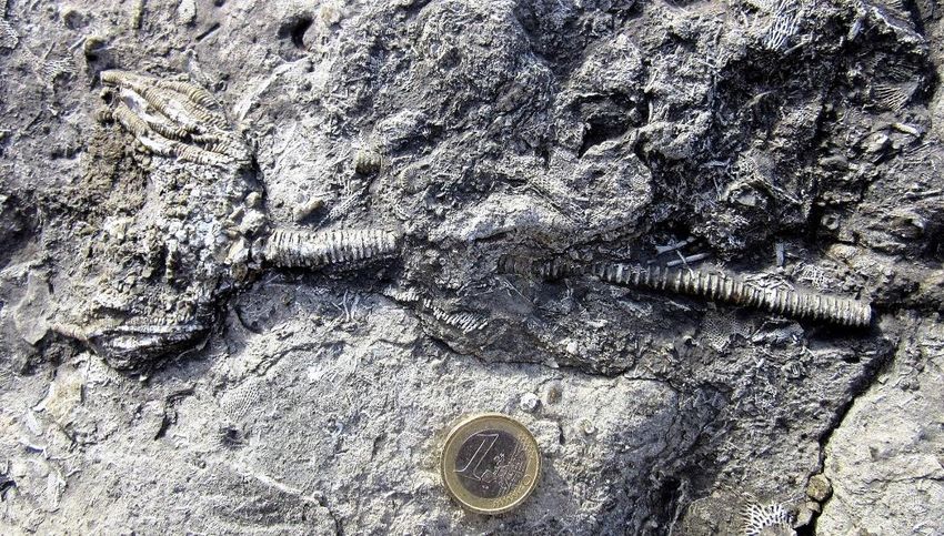
Figure 36. Birdwatching at Bannow Bay..................................................................... 45
Figure 37. Footpath at King’s Bay, Arthurstown, looking south-east........................... 47
Figure 38. Large mixed flock of roosting gulls, looking north-west.............................. 47
Figure 39. Pod of Bottlenose Dolphins passing Hook Head. ...................................... 48
Figure 40. Whale watching press cutting.................................................................... 49
Figure 41. A Tintern Trail through the woods. ............................................................ 50
Figure 42. Part of the Slí Charman walking trail. ........................................................ 52
Figure 43. The Norman Way. ..................................................................................... 54
Figure 44. Baginbun, a Green Coast Award beach. ................................................... 55
Figure 45. Tintern River, a place of beauty and tranquillity. ........................................ 56
Figure 46. Dr Daniel Buckley giving a public talk about bats at Tintern Abbey. .......... 56
Figure 47. The Peacock is one of Ireland’s largest and most colourful butterflies. ...... 57
Figure 48. Short-eared Owl at Newtown. ................................................................... 60
Figure 49. Fethard saltmarsh from Fethard Bridge. .................................................... 61
Figure 50. Dog Whelks feeding on barnacles on the Keeragh Islands. ...................... 64
Figure 51. Top visitor attraction in 2016. .................................................................... 67

                             ― List of Tables ―
Table 1. Proposed Natural Heritage Areas................................................................. 24
Table 2. Fossil sites in the project area. ..................................................................... 28
Table 3. Statutory instruments covering Natura 2000 sites. ....................................... 30
Table 4. CGSs in SACs. ............................................................................................ 32
Table 5. Qualifying interest habitats of the SACs. ...................................................... 33
Table 6. Natura 2000 habitats and species. ............................................................... 40
Table 7. Existing attractions. ...................................................................................... 57

SWC Promotions                   Hook Rural Tourism Ltd :: Biodiversity Feasibility Study                Page 8 of 80.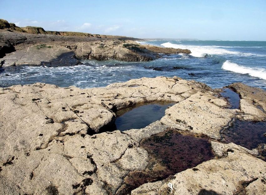
― Acknowledgements ―
Several people commented favourably on the earlier draft of this report, circulated it to
other interested parties, provided further information and/or photographs, and shared
their knowledge of, and wildlife experiences in, the project area. Their comments,
inputs, encouragement and assistance are all greatly appreciated.
The following made submissions or contributed more detailed comments regarding
their areas of expertise and the biodiversity of the project area. Their inputs are
gratefully acknowledged as their inputs contributed significantly to improving the earlier
draft report.
   ❑ Sinéad O’Brien, Executive Officer, Development Applications Unit, and the
      National Parks and Wildlife Service.
   ❑ Aileen Dowling, Fáilte Ireland, Ireland’s Ancient East Officer for Co Wexford.
   ❑ Billy Byrne, Tourism Development Officer, Economic and Enterprise
      Development, Wexford County Council
   ❑ Karin Dubsky, Director, Coastwatch.
   ❑ Paul Green, Vice-County Recorder for Co Wexford for the Botanical Society of
      Britain and Ireland.
   ❑ Dr Yvonne Byrne, Rural Development Consultancy Limited.
   ❑ John Lovatt, author of ‘Birds of Hook Head’.
   ❑ Pádraig Whooley, Sightings Officer, Irish Whale and Dolphin Group.
   ❑ Liam Ryan, local farmer, photographer, naturalist and author.
   ❑ Regina Classen, Marine Project Officer, Irish Wildlife Trust.
Thanks too to Alison Little for highlighting the ongoing need for dedicated walks along
the coast of the project area rather than on public roads with no footpaths, and to
Martin Power for sharing his extensive knowledge of the biodiversity of Carrickbyrne
Hill.
And, last but by no means least, I thank Hook Rural Tourism Limited for taking the
initiative to do more to promote the biodiversity of the Hook Peninsula and for involving
me in it. I especially thank John Rogers of Hook Tourism who assisted the project in
several ways, proofread this report, and helped bring this feasibility study to what I
hope is a successful conclusion for the promotion and conservation of the biodiversity
of the wonderful natural amenity that is the Hook Peninsula.

                                                                                    Jim Hurley,
                                                                                    12 Jan 2021

SWC Promotions           Hook Rural Tourism Ltd :: Biodiversity Feasibility Study     Page 9 of 80.
SWC Promotions Hook Rural Tourism Ltd :: Biodiversity Feasibility Study Page 10 of 80.
1. INTRODUCTION
        Background
   1.1.1.   The Promoter. This project is promoted by Hook Rural Tourism Limited, a
            community-based organisation on the Hook Peninsula in south-west
            County Wexford. The organisation has been in existence for over 50 years
            and is a not-for-profit enterprise. Among the very many different aspects of
            its work, it promotes the Hook Peninsula as a tourist destination in a
            manner that protects the area’s unspoiled coastal landscape and
            significant heritage resource values. Contact details: Hook Rural Tourism
            Limited, Duncannon, New Ross, Co Wexford Y34 X593. Email:
            info@hooktourism.com. ‘Phone: +353 (0)51 389530. Website:
            https://hookpeninsula.com/.
   1.1.2.   The Project. The overall project is called the ‘Hook Peninsula Biodiversity
            Project’.
   1.1.3.   This study. This study, the ‘Biodiversity Feasibility Study’, is the first step
            in advancing the ‘Hook Peninsula Biodiversity Project’. Basically, this study
            is tasked with drawing up an inventory of the resources of the project area
            and recommending how these natural heritage resource values can best
            be presented for both local people and visitors to experience and enjoy.
   1.1.4.   Biodiversity. Biodiversity is generally understood to mean the diversity of
            life forms found in a particular place. In addition to the living life forms, the
            biodiversity of the Hook Peninsula is considered to include the abundant
            extinct life forms to be seen in fossilised form in rock exposures. However,
            while fossils are included, both the structural and other elements of the
            geology and the geomorphology of the area are outside the remit of the
            present project.
   1.1.5.   Feasibility study. A feasibility study is an assessment of the practicality of
            a proposed plan. The proposed plan is the desire of Hook Rural Tourism
            Limited to do more to promote the biodiversity of the area. It is self-evident
            that that proposed plan is entirely practical and laudable. The overall aim
            of the project is to evaluate how best to disseminate information on the
            biodiversity of the area, via a variety of media to local residents, and to the
            public and tourists visiting the Hook Peninsula, and to identify which
            locations to direct people to to experience and enjoy local wildlife.
   1.1.6.   Project area. For the purposes of this project the spatial extent of ‘the
            Hook Peninsula’ is defined as the mapped area shown in Figure 1 above,
            in Appendix 1 at Section 22.1 below, and at https://hookpeninsula.com/wp-
            content/uploads/2019/09/Hook-Peninsula-Map-and-Listings.pdf.
   1.1.7.   Funding. This project is funded by Hook Rural Tourism Limited with
            LEADER grant aid from Wexford Local Development under Theme 3:
            Rural Environment, Sub Theme: Protection and Improvement of Local
            Biodiversity (Project Reference: 33LDRWEX111964).

SWC Promotions          Hook Rural Tourism Ltd :: Biodiversity Feasibility Study   Page 11 of 80.
Terms of reference
1.2.1. Jim Hurley, SWC Promotions, was commissioned by Hook Rural Tourism
Limited to compile this report.
1.2.2. Specific criteria of his terms of reference are set out in the project brief
below (Appendix 2, Section 22.2).
1.2.3. The brief for this ‘Biodiversity Feasibility Study’ comprises the following five
elements.
• a desk study researching existing published works, scientific literature,
websites, and other information sources to identify and list the natural
heritage resource values of the project area, areas of specific
protection, areas of special interest, unique flora or fauna, etc.,
• from that overall inventory to identify and recommend areas and items
likely to be of interest to a general audience and things that people
might realistically expect to be able to see during a visit to the area and
the heritage aspects that Hook Rural Tourism Limited should promote
by various means and employing a variety of media to disseminate
information,
• site visits to check out and review key locations,
• consultations with key stakeholders, information providers, and other
interested parties, and
• the collation and compiling of all of the information gained in a final
report.
Note. Site visits were curtailed, and several proposed meetings did not
happen due to necessary government restrictions imposed as a result of
the COVID-19 pandemic.
Figure 2. The River Barrow at New Ross.
(Photo: Jim Hurley)
SWC Promotions Hook Rural Tourism Ltd :: Biodiversity Feasibility Study Page 12 of 80.2. NATURAL HERITAGE RESOURCES
Introduction
2.1.1. While the project area enjoys a wealth of natural resources in terms of
clean air, unpolluted waters, a great diversity of underlying bedrocks, a
variety of fertile soil types, distinctive landscapes with sea views, clean
beaches, etc., the focus of this report is the area’s biological resources.
2.1.2. Surveys of the natural heritage resource values of the project area have
been ongoing since the 1970s (Goodwillie, 1979). Most biodiversity hot
spots in the area have been identified by now and the most important ones
have been designated. While conservation objectives have been published
and legislation has been enacted to protect these resources, many fail to
achieve favourable conservation status. Management plans and the
conservation measures that need to be taken to conserve and/or restore
these sites are not in place and may be the subject of legal action taken
against Ireland by the European Commission.
2.1.3. In order of their importance for biodiversity, protected areas comprise five
Natura 2000 sites, one Ramsar Site, and six proposed Natural Heritage
Areas. These twelve areas are described individually below.
2.1.4. While the Keeragh Islands are widely flagged a Natural Heritage Area
there is no statutory instrument to give effect to such a designation.
2.1.5. Bannow Bay is a ‘Wildfowl Sanctuary’ (No WFS-65), that is, it is an area
excluded from ‘Open Season Orders’ so that game birds can rest and feed
undisturbed. Shooting of game birds is not allowed in wildfowl sanctuaries
(https://www.npws.ie/protected-sites/wildfowl-sanctuaries).
Figure 3. A male Beautiful Demoiselle.
(Photo: Jim Hurley)
The Beautiful Demoiselle has metallic cobalt wings and is a common
damselfly along the banks of the Corock River. It flies from late May
to early September.
SWC Promotions Hook Rural Tourism Ltd :: Biodiversity Feasibility Study Page 13 of 80.3. NATURA 2000 SITES
Introduction
3.1.1. The most important natural heritage resources in the project area, in
alphabetical order, are (1) Bannow Bay for its bird life, (2) Bannow Bay for
its habitats, (3) Hook Head, (4) Keeragh Islands, and (5) the River Barrow.
These five areas are important because they are Natura 2000 sites.
3.1.2. Natura 2000 sites are sites in the Natura 2000 network, a web of some
27,000 nature conservation sites spread throughout the territories of the
member states of the European Union (EU). On-going development of the
network is the centrepiece of EU policy with regard to the conservation of
nature and biodiversity
(https://ec.europa.eu/environment/nature/natura2000/index_en.htm).
3.1.3. Natura 2000 sites may be either Special Protection Areas (SPAs) for wild
birds or Special Areas of Conservation (SACs) for the habitats and species
they support. The Keeragh Islands are a SPA. Hook Head and the River
Barrow are SACs. Much of Bannow Bay has dual SPA/SAC designation
due to overlap.
SPAs SACs
River
Barrow
Bannow Bay Bannow
Bay
Keeragh
Islands
Hook Head
Figure 4. SPAs (green) and SACs (brown) in the project area.
(Source: https://gis.epa.ie/EPAMaps/AAGeoTool)
SWC Promotions Hook Rural Tourism Ltd :: Biodiversity Feasibility Study Page 14 of 80.3.1.4. Habitats are places that support wildlife. The 1992 EU Habitats Directive
sets out obligations on Member States to protect vulnerable habitats.
Annex 1 of the Directive lists 233 natural habitats found in the territories of
Member States that are of Community interest and that require the
designation of Special Areas of Conservation (SACs). Fifty-eight of these
Annex 1 habitats occur in Ireland.
3.1.5. The National Parks and Wildlife Service (NPWS), one of the technical
services of the Department of Housing, Local Government and Heritage, is
the government agency in Ireland with overall responsibility for managing
Natura 2000 sites. The NPWS website at www.npws.ie gives descriptions
of all SPAs and SACs together with maps, aerial photographs and other
useful information. The NPWS contact person for the South Wexford Coast
is Tony Murray, Conservation Ranger, telephone 076 100 2662, email
Tony.Murray@chg.gov.ie.
3.1.6. Natura 2000 sites are listed in the current Wexford County Development
Plan (WCC, 2013a), the draft plan for the period 2021-2027 (WCC, 2020),
and the County Wexford Biodiversity Action Plan (WCC, 2012), all policy
documents of Wexford County Council. These documents may be
accessed at www.wexfordcoco.ie. Via its function as the local Planning
Authority, Wexford County Council is a major player in conserving Natura
2000 sites in County Wexford. The Wexford County Council contact
person is Niamh Lennon, Biodiversity Officer, telephone 053 919 6540,
email niamh.lennon@wexfordcoco.ie.
3.1.7. Each of the five Natura 2000 sites found in the project area is described
briefly below. Full details may be accessed at www.npws.ie.
SWC Promotions Hook Rural Tourism Ltd :: Biodiversity Feasibility Study Page 15 of 80.Bannow Bay (SAC IE000697)
Extent: This site comprises Bannow Bay, the lower reaches of River Owenduff, the
River Corock as far north as Haresmead, part of the environs of Tintern Abbey,
Bannow Strand, Grange Strand and part of Fethard Bay, The Glen at Fethard and
Fethard Dock.
Qualifying interests: The
qualifying interests of the site
are the following 11 named
habitat types followed by their
EU code numbers.
➢ Estuaries [1130]
➢ Mudflats and sandflats not
covered by seawater at low
tide [1140]
➢ Annual vegetation of drift
lines [1210]
➢ Perennial vegetation of stony
banks [1220]
➢ Salicornia and other annuals
colonising mud and sand
[1310]
➢ Atlantic salt meadows
(Glauco-Puccinellietalia
maritimae) [1330]
➢ Mediterranean salt meadows
(Juncetalia maritimi) [1410]
➢ Mediterranean and thermo-
Atlantic halophilous scrubs
(Sarcocornetea fruticosi)
[1420]
➢ Embryonic shifting dunes
[2110]
➢ Shifting dunes along the
shoreline with Ammophila
arenaria (white dunes) [2120]
➢ Fixed coastal dunes with
herbaceous vegetation (grey
dunes) [2130]
Figure 5. Bannow Bay Special Area of Conservation (green fill).
(Sources: https://gis.epa.ie/EPAMaps/AAGeoTool and
http://dahg.maps.arcgis.com/apps/webappviewer/index.html?id=8f7060
450de3485fa1c1085536d477ba)
Conservation objectives: The overall aim is to maintain or restore the favourable
conservation status of habitats and species of community interest. Site-specific
conservation objectives are detailed in a 29-page report available online at
http://www.npws.ie/sites/default/files/protected-
sites/conservation_objectives/CO000697.pdf.
Overlap: This SAC overlaps, in part, with Bannow Bay SPA No IE004033 and is
adjacent to Hook Head SAC No IE000764.
SWC Promotions Hook Rural Tourism Ltd :: Biodiversity Feasibility Study Page 16 of 80.Bannow Bay (SPA IE004033)
Extent: This site comprises Bannow Bay and an area of seabed and foreshore at the
mouth of the bay.
Qualifying interest: The qualifying interests of the site are its ‘Wetland and
Waterbirds [A999]’ especially the following 13 named species followed by their EU
code numbers.
➢ Light-bellied Brent Goose Branta
bernicla hrota [A046]
➢ Shelduck Tadorna tadorna [A048]
➢ Pintail Anas acuta [A054]
➢ Oystercatcher Haematopus
ostralegus [A130]
➢ Golden Plover Pluvialis apricaria
[A140]
➢ Grey Plover Pluvialis squatarola
[A141]
➢ Lapwing Vanellus vanellus [A142]
➢ Knot Calidris canutus [A143]
➢ Dunlin Calidris alpina [A149]
➢ Black-tailed Godwit Limosa limosa
[A156]
➢ Bar-tailed Godwit Limosa lapponica
[A157]
➢ Curlew Numenius arquata [A160]
➢ Redshank Tringa totanus [A162]
Figure 6. Bannow Bay Special Protection Area (green fill).
(Sources: https://gis.epa.ie/EPAMaps/AAGeoTool and
http://dahg.maps.arcgis.com/apps/webappviewer/index.html?id=8f7060
450de3485fa1c1085536d477ba)
Conservation objectives: The overall aim is to maintain or restore the favourable
conservation status of habitats and species of community interest. Site-specific
conservation objectives are detailed in a 21-page report available online at
http://www.npws.ie/sites/default/files/protected-
sites/conservation_objectives/CO004033.pdf.
Overlap. This SPA overlaps, in part, with Bannow Bay SAC No IE000697 and joins
Hook Head SAC No IE000764.
Figure 7. Light-bellied Brent Geese feeding at Saintkierans.
(Photo: Jim Hurley)
SWC Promotions Hook Rural Tourism Ltd :: Biodiversity Feasibility Study Page 17 of 80.Colour Designation
Brown SAC only
Pale green SPA only
Darker green Dual SAC/SPA
Figure 8. Two overlapping Bannow Bay Natura 2000 sites.
(Source: https://gis.epa.ie/EPAMaps/AAGeoTool)
The bottom of the figure shows the Keeragh Islands SPA (right; green), and part of
Hook Head SAC (centre; brown).
SWC Promotions Hook Rural Tourism Ltd :: Biodiversity Feasibility Study Page 18 of 80.Hook Head (SAC IE000764)
Extent: Hook Head Special Area of Conservation (SAC) (highlighted below in the
green colour), comprises an extensive area of seabed off Hook Head together with the
foreshore of the western side of the peninsula south of Loftus Hall, all of the foreshore
of the eastern side of the peninsula, and the foreshore at Clammers Point near
Bannow.
Qualifying interests: The qualifying interests of the site are the following three named
habitat types followed by their EU code numbers.
➢ Large shallow inlets and bays [1160] (part of Ballyteige Bay)
➢ Reefs [1170] (reefs are exposures of outcropping bedrock)
➢ Vegetated sea cliffs of the Atlantic and Baltic coasts [1230]
Conservation objectives: The overall aim is to maintain or restore the favourable
conservation status of the three habitats. Site-specific conservation objectives for
Hook Head SAC are detailed in a 14-page report available online at
http://www.npws.ie/sites/default/files/protected-
sites/conservation_objectives/CO000764.pdf.
Overlap: Hook Head SAC overlaps with and adjoins a small portion of Bannow Bay
SPA No IE004033 at its northern extremity.
Figure 9. Hook Head Special Area of Conservation (green fill).
(Sources: https://gis.epa.ie/EPAMaps/AAGeoTool and
http://dahg.maps.arcgis.com/apps/webappviewer/index.html?id=8f7060
450de3485fa1c1085536d477ba)
SWC Promotions Hook Rural Tourism Ltd :: Biodiversity Feasibility Study Page 19 of 80.Keeragh Islands (SPA IE004118)
Extent: The 22-hectare protected area comprises the two Keeragh Islands, the
associated low-tide rocky shorelines and reefs, and the surrounding near-shore
seabed around both islands for a distance from the shore of 200 metres
approximately.
Figure 10. Keeragh Islands Special Protection Area (SPA) (green fill).
(Sources: https://gis.epa.ie/EPAMaps/AAGeoTool,
http://dahg.maps.arcgis.com/apps/webappviewer/index.html?id=8f7060
450de3485fa1c1085536d477ba and https://maps.wexford.ie/imaps/.)
Qualifying interest: The sole special conservation interest of the site is the population
of breeding Great Cormorants Phalacrocorax carbo [A017].
Figure 11. Great Cormorants nesting on the Big Keeragh.
(Photo: Jim Hurley)
Conservation objective: Site-specific conservation objectives have not yet been
published for the SPA. The generic conservation objective is to maintain or restore the
favourable conservation condition of the Great Cormorants (Source:
http://www.npws.ie/sites/default/files/protected-
sites/conservation_objectives/CO004118.pdf).
Overlap: The Keeragh Islands SPA does not overlap with any other Natura 2000 site.
SWC Promotions Hook Rural Tourism Ltd :: Biodiversity Feasibility Study Page 20 of 80.River Barrow and River Nore (SAC IE002162)
Extent: After the River Shannon, this river system is the
second longest in Ireland as it straddles eight counties in
south-east of the country: Carlow, Kildare, Kilkenny,
Laois, Offaly, Tipperary, Waterford and Wexford. The
site comprises freshwater, brackish water and the tidal
portion of the estuary into which the River Suir, one of
The Three Sisters, also flows. In addition to these
waters, the site comprises several adjoining wetland
habitat types and the life forms they support. The portion
in the project area lies south of New Ross.
Qualifying interests: The qualifying interests of the site
are the following 22 named habitat types and species
followed by their EU code numbers.
➢ Estuaries [1130]
➢ Mudflats and sandflats not covered by seawater at
low tide [1140]
➢ Salicornia and other annuals colonising mud and
sand [1310]
➢ Atlantic salt meadows (Glauco-Puccinellietalia
maritimae) [1330]
➢ Mediterranean salt meadows (Juncetalia maritimi)
[1410]
➢ Water courses of plain to montane levels with the
Ranunculion fluitantis and Callitricho-Batrachion
vegetation [3260]
➢ European dry heaths [4030]
➢ Hydrophilous tall herb fringe communities of plains
and of the montane to alpine levels [6430]
➢ Petrifying springs with tufa formation
(Cratoneurion) [7220]
➢ Old sessile oak woods with Ilex and Blechnum in
the British Isles [91A0]
➢ Alluvial forests with Alnus glutinosa and Fraxinus
excelsior (Alno-Padion, Alnion incanae, Salicion
albae) [91E0]
➢ Vertigo moulinsiana (Desmoulin's Whorl Snail)
[1016]
➢ Margaritifera margaritifera (Freshwater Pearl
Mussel) [1029]
➢ Austropotamobius pallipes (White-clawed Crayfish)
[1092]
➢ Petromyzon marinus (Sea Lamprey) [1095]
➢ Lampetra planeri (Brook Lamprey) [1096]
➢ Lampetra fluviatilis (River Lamprey) [1099]
➢ Alosa fallax (Twaite Shad) [1103]
➢ Salmo salar (Salmon) [1106]
➢ Lutra lutra (Otter) [1355]
➢ Trichomanes speciosum (Killarney Fern) [1421]
➢ Margaritifera durrovensis (Nore Pearl Mussel)
[1990]
Conservation objectives: The overall aim is to maintain or restore the favourable
conservation status of habitats and species of community interest. Site-specific
conservation objectives are detailed in a 46-page report available online at
http://www.npws.ie/sites/default/files/protected-
sites/conservation_objectives/CO002162.pdf.
SWC Promotions Hook Rural Tourism Ltd :: Biodiversity Feasibility Study Page 21 of 80.Summary map slowing the locations of Natura 2000 sites in the
project area.
Designated Special
Areas of
Conservation
(SACs) are shown
filled with upward
diagonal red lines.
The Hook Head
SAC is largely a
triangular area of
seabed south and
east of the
peninsula.
The River Barrow
SAC extends
southwards from
New Ross. Its
southern boundary
is a line across
Waterford Harbour
from Creadon Head
in Co Waterford to
Broomhill Point in
Co Wexford.
Designated Special
Protection Areas
(SPAs) are shown
filled with downward
diagonal magenta
lines.
The small Keeragh
Islands SPA lies
offshore south of
Carrick.
Bannow Bay has
dual designation, so
the overlapping
upward diagonal red
lines and the
downward diagonal
magenta lines form
a cross-hatched
pattern where they
coincide.
Figure 12. Designated Natura 2000 sites.
(Source:
http://dahg.maps.arcgis.com/apps/webappviewer/index.html?id=8f7060
450de3485fa1c1085536d477ba)
SWC Promotions Hook Rural Tourism Ltd :: Biodiversity Feasibility Study Page 22 of 80.4. BANNOW BAY RAMSAR SITE
4.1.1. Named after the city of Ramsar in Iran, where the Convention was signed
in 1971, and also known by its short name: the ‘Convention on Wetlands’,
the Ramsar ‘Convention on Wetlands of International Importance
especially as Waterfowl Habitat’, is an international treaty for the
conservation and sustainable use of wetlands
(https://www.ramsar.org/about-the-convention-on-wetlands-0).
4.1.2. The Convention’s mission is “the conservation and wise use of all wetlands
through local and
national actions and
international
cooperation, as a
contribution towards
achieving sustainable
development throughout
the world”.
4.1.3. The Convention
on Wetlands is the
intergovernmental treaty
that provides the
framework for the
conservation and wise
use of wetlands and their
resources.
4.1.4. Bannow Bay
was designated Ramsar
site number 840 by the
Irish government on 11
June 1996. The site
overlaps part of the
designated Natura 2000
site (Figure 13).
Figure 13. Ramsar site No 840.
(Source: Irish Ramsar Wetlands Committee at http://irishwetlands.ie/irish-sites/.
Ordnance Survey Ireland Permit No MP 0002120. © Ordnance
Survey Ireland/Government of Ireland)
The Irish Ramsar Wetlands Committee was
set up by the government to assist Ireland in
meeting its requirements as a signatory to the
Ramsar Convention.
The Committee is a widely representative
group, set up to assist in the protection,
appreciation and understanding of wetlands in
Ireland and to promote the implementation of
the Convention.
For further information see
http://irishwetlands.ie/.
SWC Promotions Hook Rural Tourism Ltd :: Biodiversity Feasibility Study Page 23 of 80.5. PROPOSED NATURAL HERITAGE AREAS
Introduction
5.1.1. The basic designation for wildlife in Ireland is the Natural Heritage Area
(NHA). This is an area considered important for the habitats present or
which holds species of plants and animals whose habitat needs protection
(https://www.npws.ie/protected-sites/nha).
5.1.2. In 1995, 630 sites of significance for wildlife and habitats were identified as
proposed NHAs (pNHAs); these were published on a non-statutory basis.
Six of the pNHAs are in the project area (Table 1 and Figure 14). To date,
none has been statutorily proposed or designated. It is intended to review
the conservation status of these sites over the coming years with a view to
reassessing their conservation value for possible designation.
Name of the pNHA Code No Area (ha)
Ballyhack 000695 8.62
Ballykelly Marsh 000744 11.04
Boley Fen 000699 47.82
Duncannon Sandhills 001738 68.65
Oaklands Wood 000774 36.51
Tintern Abbey 000711 0.49
Table 1. Proposed Natural Heritage Areas.
(Source:
http://dahg.maps.arcgis.com/apps/webappviewer/index.html?id=8f7060
450de3485fa1c1085536d477ba)
5.1.3. In alphabetical order, each of these six pNHA sites is described briefly
below from the National Parks and Wildlife Service’s pNHA Site Synopses
PDF portfolio archive at
https://www.npws.ie/sites/default/files/general/pNHA_Site_Synopsis_Portfo
lio.pdf with accompanying maps (blue hatching) sourced from
https://maps.wexford.ie/imaps/.
In addition to the six pNHAs
shown here there are several
Oaklands Wood
small areas of pNHA around
the Bannow Bay, Hook Head
Ballykelly Marsh
and River Barrow Natura 2000
sites that, for one reason or
Boley Fen another, were not included in
the Natura 2000 sites when
Ballyhack
Tintern these sites were designated.
Abbey These small areas are not
named and the reasons for
Duncannon
Sandhills
their inclusion as pNHAs, and
their exclusion from the Natura
2000 sites, are not known.
Figure 14. Locations of six pNHAs.
SWC Promotions Hook Rural Tourism Ltd :: Biodiversity Feasibility Study Page 24 of 80.Ballyhack (pNHA No 000695)
This 8.62ha site extends along the R770 road from Ballyhack to Arthurstown. While
there is no information in the National Parks and Wildlife Service’s pNHA Site
Synopses PDF portfolio archive, the site was originally selected because its landward
side supported good examples of the species-rich plant communities found on thin
soils and on sandstone rock. Stands of Clustered Clover (Trifolium glomeratum) were
of particular note. The top of the roadside sea wall also supported a diverse range of
wild plants (Goodwillie, 1979 pages 83-85). Almost all of the pNHA is already in the
River Barrow and River Nore SAC.
Ballykelly Marsh (pNHA No 000744)
“This site combines an arable field with a high quality wetland site. The arable field
contains a rare arable weed community including the protected flora species Sharp-
leaved Fluellen (Kickxia elatine). Adjacent to this field is a small species-rich lake and
fen area. Such small wetlands are characteristic of the south-east of Ireland but are
decreasing rapidly due to drainage and land reclamation.” (NPWS Site Synopsis dated
12.11.2009). The privately-owned site covers an area of 11.04ha.
SWC Promotions Hook Rural Tourism Ltd :: Biodiversity Feasibility Study Page 25 of 80.Boley Fen (pNHA No 000699)
A fen is a wetland system with a permanently
high water level at, or just below, its surface.
Fens are usually not as acid as bogs.
“Boley Fen is located at Rathumney,
approximately 5km east of Campile, in Co.
Wexford. It comprises intermediate fen with wet
grassland and tall sedge (Carex spp.)
communities with encroaching scrub, mainly
willows (Salix spp.). Areas of the site have been
afforested. The site is of interest due to its
location; fens are uncommon in south-east
Ireland. More importantly, it is noted as nationally
important for the following rare species of Diptera
(flies): Anasimyia lunulata, Psacadina zernyi,
Parhelophilus consimilis, Pteromicra
angustipennis and Tetanocera punctifrons.”
(NPWS Site Synopsis dated 12.11.2009).
The privately-owned site at Boley covers an area of 47.82ha.
Duncannon Sandhills (pNHA No 001738)
This 68.65ha site extends around the rocky headland at Duncannon Fort, eastwards
along the seashell-rich beach, through the dunes and continues up the valley of the
Kilbride stream together with its associated wetlands. There is no information about
the site in the National Parks and Wildlife Service’s pNHA Site Synopses PDF portfolio
archive. Almost all of the pNHA is already in the River Barrow and River Nore SAC.
The site was most likely selected because it supports a diverse range of habitats and
some rare plants, especially Wild Clary (Salvia verbenaca) an aromatic sage and
member of the mint family. Wild Clary is a knee-high, hairy plant that supports long,
loose spikes of bluish-purple flowers between June and September. It is a native
species in Ireland, but it is rare and is confined to a number of coastal areas, one of
which is Duncannon. However, it has not been seen there since 2010 (personal
communication, Paul Green). The area is also important for seabirds. In autumn, the
beach supports the most important post-breeding aggregation of Sandwich Terns in
Co Wexford (Burke, et al., 2020) and roosting gulls are present throughout the winter
months.
SWC Promotions Hook Rural Tourism Ltd :: Biodiversity Feasibility Study Page 26 of 80.Oaklands Wood (pNHA No 000774)
“This site is a mixed coniferous and deciduous wood located approximately 2km south
of New Ross in Co. Wexford. Oak (Quercus spp.) is the dominant species in parts of
this wood, although coniferous species have been widely planted. Beech (Fagus
sylvatica) also occurs
and is regenerating.
The trees reach
about 15m in height
and create a closed
canopy above
abundant Holly (Ilex
aquifolium). The
ground flora includes
Bilberry (Vaccinium
myrtillus) and Great
Wood-rush (Luzula
sylvatica), with a
variety of woodland
herbs such as Wood-
sorrel (Oxalis
acetosella), Bluebell
(Hyacinthoides non-
scripta), Sanicle
(Sanicula europaea), Goldenrod (Solidago vigaurea) and Hard Fern (Blechnum
spicant). Tree felling, coupled with replanting with coniferous species, has occurred
within the site. If allowed to continue, this will damage the interest of the area. The site
is of interest as it is a representative area of broadleaved woodland and its associated
flora.” (NPWS Site Synopsis dated 12.11.2009).
The low-lying portion of the 36.51ha woodland, also known as Kelly’s Wood, is now
flooded and is being managed as a coarse angling amenity and resource
(https://oaklandslake.com/).
Tintern Abbey (pNHA No 000711)
This tiny site comprises the abbey and its associated outbuildings. These structures
support breeding colonies of a number of species of bats including
the rare Whiskered Bat.
“A nursery colony of Whiskered Bat (Myotis mystacinus) was
recorded in the roof of a building in
the grounds of Tintern Abbey, Co.
Wexford in 1987. The building was
in a bad state of repair at that time
and has since collapsed. Other
sections of the abbey were restored
by the Office of Public Works in 1993. It is possible that
the colony remained in the area and if this is the case,
the new roosting site should be fully protected. As the
national population of this species is only several
hundred, all nursery colonies are of national
importance.” (NPWS Site Synopsis dated 12.11.2009).
(Photo: Jim Hurley)
Figure 15. Bat in the hand of a licenced bat researcher.
SWC Promotions Hook Rural Tourism Ltd :: Biodiversity Feasibility Study Page 27 of 80.6. FOSSIL SITES
6.1.1. Information on 42 sites in County Wexford that are of geological,
geomorphological and/or earth sciences importance is contained in an
audit of such resources (Meehan et al, 2019). Twelve of these 42 sites are
in the project area (Figure 16; yellow stars). Five of the 12 project area
sites are fossil sites: Booley Bay, Hook Head, Loftusacre, Oldtown to
Harrylock Bay, and Sandeel Bay.
Figure 16. Map of geological heritage sites in Co Wexford.
(Source: Meehan et al, 2019, Section 2, page 4)
6.1.2. The approximate age of each fossil site is measured in millions of years
ago (Table 2).
Site Fossils Age
Soft-bodied, oceanic life forms and
Booley Bay 490
jellyfish-like creatures
Loftusacre Starfish, graptolites and lamp shells 450
Oldtown to Harrylock Bay Plants and plant spores 375
Sandeel Bay Tree ferns and other plants 375
Hundreds of species of shallow-
Hook Head 350
water, marine animals
Table 2. Fossil sites in the project area.
(Source: Meehan et al, 2019 and
https://stratigraphy.org/icschart/ChronostratChart2020-03.pdf)
SWC Promotions Hook Rural Tourism Ltd :: Biodiversity Feasibility Study Page 28 of 80.6.1.3. The locations of the five fossil sites are shown below (Figure 17); more
detailed site location maps are available (Meehan et al, 2019).
Booley Loftusacre
Bay
Oldtown to
Harrylock
Bay
Sandeel Bay
Hook Head
Figure 17. Locations of five fossil sites.
(Source: Meehan et al, 2019)
Figure 18. Sandeel Bay, an important fossil site.
(Photo: Jim Hurley)
SWC Promotions Hook Rural Tourism Ltd :: Biodiversity Feasibility Study Page 29 of 80.7. AREAS OF SPECIFIC PROTECTION
Natura 2000 sites
7.1.1. The five Natura 2000 sites in the project area are subject to the greatest
level of site protection (https://www.npws.ie/protected-sites). Four of the
five sites are covered by a statutory instrument (Table 3). While legislation
is pending, the outstanding site enjoys similar protection as case law has
ruled that Natura 2000 sites are protected from the time they are first
advertised.
Natura 2000 site Statutory instrument (S I)
S I No 420 of 2018 at
Bannow Bay SAC
http://www.irishstatutebook.ie/eli/2018/si/420/made/en/pdf
S I No 592 of 2011 at
Bannow Bay SPA
http://www.irishstatutebook.ie/eli/2011/si/592/made/en/print
S I No 509 of 2017 at
Hook Head SAC
http://www.irishstatutebook.ie/eli/2017/si/509/made/en/pdf
Keeragh Islands S I No 68 of 2010 at
SPA http://www.irishstatutebook.ie/eli/2010/si/68/made/en/print
River Barrow and
River Nore Legislation pending
candidate SAC
Table 3. Statutory instruments covering Natura 2000 sites.
Proposed NHAs
7.2.1. Prior to review and status evaluation for possible statutory designation, the
six proposed Natural Heritage Areas (pNHAs) detailed above (Section 5)
are subject to limited protection in the form of:
➢ Agri-environmental farm planning schemes support the objective of
maintaining and enhancing the conservation status of pNHAs.
➢ Forest Service requirement for NPWS approval before they will pay
afforestation grants on pNHA lands.
➢ Recognition of the ecological value of pNHAs by Planning and
Licencing Authorities.
(Source: https://www.npws.ie/protected-sites/nha)
7.2.2. In addition to these six pNHAs, there are several small areas of pNHA
around the Bannow Bay, Hook Head and River Barrow Natura 2000 sites
that, for one reason or another, were not included in the Natura 2000 sites
when these sites were designated. These small areas are not named and
both the reasons for their inclusion as pNHAs, and their exclusion from the
Natura 2000 designation process are not known. Since the Natura 2000
designation process has been completed for the sites in question, it
appears unlikely that additional small areas will be added without good
reasons for doing so.
SWC Promotions Hook Rural Tourism Ltd :: Biodiversity Feasibility Study Page 30 of 80.Bannow Bay Ramsar site
7.3.1. Bannow Bay does not derive any legal protection on foot of its designation
a Ramsar site. Protection stems from the site’s dual designation a Special
Area of Conservation (SAC) and Special Protection Area (SPA).
Figure 19. Cowslips in St Mary’s Church graveyard at Saltmills.
(Photo: Jim Hurley)
Figure 20. The Blue Jellyfish is a scarce native at Bannow Bay.
(Photo: Jim Hurley)
SWC Promotions Hook Rural Tourism Ltd :: Biodiversity Feasibility Study Page 31 of 80.Fossil sites
7.4.1. The five fossil sites detailed above (Section 6) are all on the seashore so,
in a general way they come under the provisions of the Foreshore Act (S I
No 12 of 1933 as revised and updated to 11 December 2014;
https://www.lawreform.ie/_fileupload/RevisedActs/WithAnnotations/EN_AC
T_1933_0012.PDF).
7.4.2. Sites of geological importance are recognised in the draft Wexford County
Development Plan 2021-2027 (WCC, 2020). Of the 42 sites identified in
Co Wexford (Meehan et al., 2018), 16 are rated of national importance and
these are recognised in the draft plan as County Geological Sites (CGSs)
(WCC, 2020 pages 497-500 and Table 13.3). All five fossil sites in the
project area are CGSs as they are listed among the 16 sites of national
importance. The protection of these sites is given due consideration by the
County Council’s Planning and Licencing Authorities.
7.4.3. Three of the five fossil sites gain further legal protection by virtue of the
fact that they are located within the boundaries of a Special Area of
Conservation (SAC) (Table 4).
County Geological Located in Special Area of
Site (CGS) Conservation (SAC)
River Barrow and River Nore
Booley Bay
SAC No IE002162
Loftusacre None
Oldtown to Harrylock Bay None
Sandeel Bay Hook Head SAC No IE000764
Hook Head Hook Head SAC No IE000764
Table 4. CGSs in SACs.
Figure 21. The stalk and crown of a fossil crinoid or Sea Lily at Hook Head.
(Photo: Jim Hurley)
SWC Promotions Hook Rural Tourism Ltd :: Biodiversity Feasibility Study Page 32 of 80.8. AREAS OF SPECIAL INTEREST
Introduction
8.1.1. The expression ‘areas of special interest’ is understood to mean both
features of, and places in, the project area that are unique or intensely
interesting for some reason. These areas of special interest are considered
below under the following three headings: habitats, species and places.
Habitats of special interest
8.2.1. A habitat is a place where plants and animals live, for example, a pond, a
wood, a rocky seashore, etc.
8.2.2. One hundred and seventeen habitat types have been identified and
documented in Ireland (Fossitt, 2000). Fine examples of many of these
habitats are to be found throughout the project area.
8.2.3. Arising from its concern regarding the loss of biodiversity through the
territory of the European Union (EU), the European Commission (EC)
contracted a panel of experts to identify the habitats that were under most
threat in the territory of the EU and that Member States needed to take
action to protect. The resulting list of vulnerable habitats is known as
‘Annex 1’ of the Habitats Directive (EC, 1992). Annex 1 lists 233 habitats,
each of which is defined and described (EC, 2013). The Directive requires
that Member States designate Special Areas of Conservation (SACs) to
conserve representative examples of these habitats. Fifty-eight of the 233
vulnerable Annex 1 habitats occur in Ireland (NPWS, 2019a and NPWS,
201b). The following 17 of these 58 habitats are qualifying interests of the
three SACs in the project area (Table 3).
Annex 1 habitat name and [code] HH BB RB
Estuaries [1130] ◼ ◼
Mudflats and sandflats not covered by seawater at low tide [1140] ◼ ◼
Large shallow inlets and bays [1160] ◼
Reefs [1170] ◼
Annual vegetation of drift lines [1210] ◼
Perennial vegetation of stony banks [1220] ◼
Salicornia and other annuals colonising mud and sand [1310] ◼ ◼
Atlantic salt meadows (Glauco-Puccinellietalia maritimae) [1330] ◼ ◼
Mediterranean salt meadows (Juncetalia maritimi) [1410] ◼ ◼
Mediterranean and thermo-Atlantic halophilous scrubs (Sarcocornetea fruticosi)
◼
[1420]
Embryonic shifting dunes [2110] ◼
Shifting dunes along the shoreline with Ammophila arenaria (white dunes) [2120] ◼
*Fixed coastal dunes with herbaceous vegetation (grey dunes) [2130] ◼
Vegetated sea cliffs of the Atlantic and Baltic coasts [1230] ◼
Water courses of plain to montane levels with the Ranunculion fluitantis and
◼
Callitricho‐Batrachion vegetation [3260]
Old sessile oak woods with Ilex and Blechnum in the British Isles [91A0] ◼
*Alluvial forests with Alnus glutinosa and Fraxinus excelsior (Alno‐Padion, Alnion
◼
incanae, Salicion albae) [91E0]
Table 5. Qualifying interest habitats of the SACs.
(Source: NPWS, 2011a, NPWS,2011b and NPWS2012b)
◼ = The habitat is a qualifying interest of the particular SAC.
HH = Hook Head, BB = Bannow Bay, and RB = the River Barrow south of
New Ross.
SWC Promotions Hook Rural Tourism Ltd :: Biodiversity Feasibility Study Page 33 of 80.Figure 22. Reefs and rock pools exposed on the shore at low tide.
(Photo: Jim Hurley)
8.2.4. A saltmarsh is defined as an expanse of coastal vegetation that, while it
need not necessarily be marshy, is
regularly flooded by saltwater (IRWC,
2018). One of the very rarest of the 58
Annex 1 habitats found in Ireland is a
type of saltmarsh called ‘Mediterranean
and thermo-Atlantic halophilous scrubs
(Sarcocornetea fruticosi)’, Code No
1420. In Ireland, that particular habitat is
found only on the South Wexford Coast
at two locations: Bannow Bay and
Ballyteige Lough making it the habitat of
greatest interest in the project area
(attached distribution map from NPWS,
2019a page 18).
8.2.5. The remaining 16 Annex 1 habitats found in the project area are
reasonably common throughout Ireland. The most significant habitats
found in the project area are ‘grey dunes’ and ‘alluvial forests’ because
both of these are rated ‘priority habitats’ in need of stricter protection.
SWC Promotions Hook Rural Tourism Ltd :: Biodiversity Feasibility Study Page 34 of 80.8.2.6. ‘Fixed coastal dunes with herbaceous vegetation (''grey dunes'')’, Code No
2130, are a priority habitat. Small examples of these dunes occur at both
sides of the mouth of Bannow Bay: at Bannow Strand and Bannow Island
on the eastern side and at Grange on the western side (Figure 23; yellow).
Figure 23. Grey dunes (yellow) at the mouth of Bannow Bay.
(Source: NPWS, 2012b, Map 7 extract)
8.2.7. Grey dunes are subject to coastal erosion (Figure 24), so much so that the
former extensive area of tall dunes known as ‘Big Burrow’ no longer exists.
These dunes supported a diverse flora including three prostrate specimens
of Wild Privet (Ligustrum vulgare) at the northern edge of the dunes, a
shrub that is fairly frequent as a planted garden hedge and garden escape
but very rare as a native on sand dunes (Parnell and Curtis, 2012 page
332). Big Burrow was one of two sites in Ireland that supported dune scrub
of Wild Privet, the other site being Tramore, Co Waterford (personal
communication, Tom Curtis, NPWS and New Ross Standard, issue of 18
September 1996, page 10).
Figure 24. Erosion of a dune face at Big Burrow.
(Photo: Jim Hurley, circa1989)
SWC Promotions Hook Rural Tourism Ltd :: Biodiversity Feasibility Study Page 35 of 80.You can also read