Plan including minor modifications - Infrastructure Delivery County Durham Plan 2019 - Durham County ...
←
→
Page content transcription
If your browser does not render page correctly, please read the page content below
County Durham Plan
Infrastructure Delivery
Plan including minor
modifications
2019
Contents
Executive Summary 2
1 Introduction 4
What is the Infrastructure Delivery Plan? 4
The Scope of the Infrastructure Delivery Plan 6
Partnership Working 6
IDP Investment Schedules 7
2 County Durham Plan 7
Proposed Housing Distribution in County Durham 7
Employment Land 10
3 Monitoring Areas 15
Countywide 15
Countywide Physical Infrastructure 15
Countywide Social Infrastructure 26
Countywide Green Infrastructure 35
North Durham 36
North West Durham 41
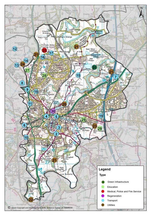
Durham City 45
Central Durham 55
Mid Durham 59
South Durham 63
South East Durham 69
East Durham 73
West Durham 79
Infrastructure Delivery Plan June 2019 County Durham Plan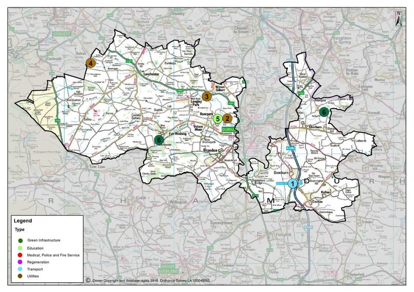
Infrastructure Delivery Plan June 2019

  Executive Summary
  The County Durham Infrastructure Delivery Plan (IDP) describes County Durham's
  infrastructure requirements to support the delivery of the County Durham Plan (CDP) until
  2035. The IDP has been developed in partnership with providers to identify infrastructure
  needs, delivery costs, and particularly seeks to identify barriers such as shortfalls in finance
  relating to infrastructure delivery. The IDP assists partners to make efficient decisions about
  their own investment programmes and has been developed in co-operation with adjoining
  local authorities to identify cross boundary issues.

  The IDP highlights the key developments identified in the CDP, including where future housing
  and employment land will be located, and identifies those places where additional infrastructure
  or capacity is needed in the future.

  Some of the key infrastructure requirements include new sustainable methods of transport,
  highways improvements, connectivity and utilities coverage across the County, along with a
  detailed assessment of where and when water sewerage networks will require investment.
  The IDP also considers the social infrastructure, which is crucial to improving our communities,
  such as medical care, emergency services, education facilities and community facilities.
  Green Infrastructure (GI) improvements also form part of the IDP process although separate
  GI Frameworks are being developed in partnership with key stakeholders. These GI
  Frameworks will contain more detail regarding specific projects and GI requirements.

      Structure

      The IDP has two main sections:

           The REPORT describes specific types of infrastructure in County Durham and
           highlights future investment issues and the impact of the County Durham Plan.

                                   (i)
           The SCHEDULE is the financial breakdown of investment across monitoring areas.
           It states what infrastructure funding is (and is not) in place.

  i     The IDP schedule is located at the back of each monitoring area

2 County Durham Plan Infrastructure Delivery Plan June 2019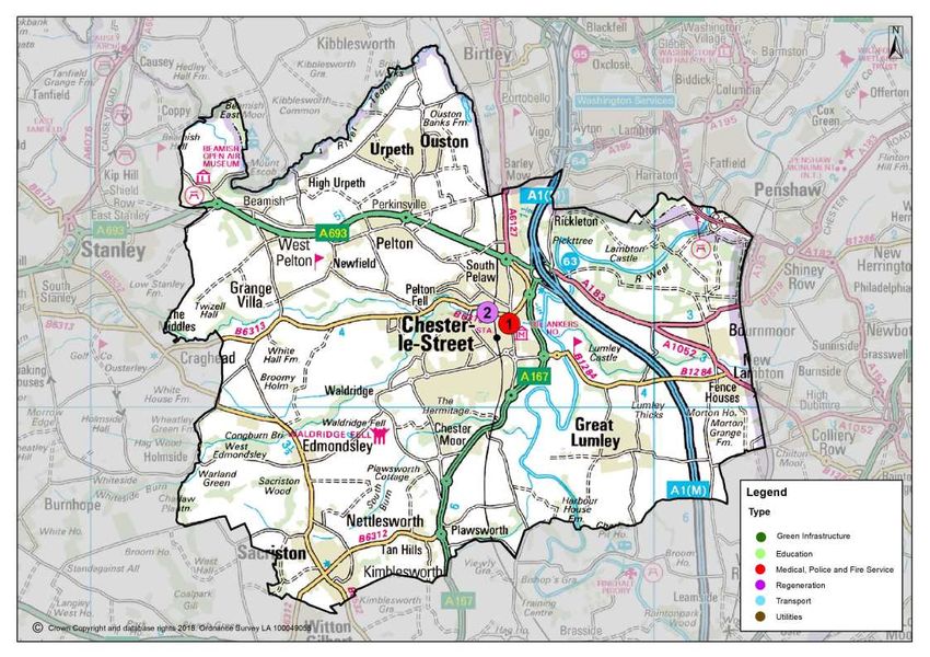
Infrastructure Delivery Plan June 2019

                               Estimated Indicated Funding Gap

            Countywide                                                 £4,750,000

            North Durham Monitoring Area                               £4,000,000

            North West Durham Monitoring Area                         £13,786,480

            Durham City Monitoring Area                              £148,265,340

            Central Durham Monitoring Area                             £1,102,725

            Mid Durham Monitoring Area                                 £4,756,130

            South Durham Monitoring Area                              £19,540,000

            South East Durham Monitoring Area                                  £0

            East Durham Monitoring Area                                £6,989,860

            West Durham Monitoring Area                                        £0

            Total                                                    £183,650,535

The table above highlights the total funding gap for projects identified in the IDP. It must be
noted that some of these projects are dependent upon developer contributions from sites
which are proposed to be allocated for development in the County Durham Plan
Pre-Submission Draft 2019.

In order to aid monitoring across an area the size of County Durham, with its many different
communities, it is useful to break the county down into geographical areas which have similar
characteristics in terms of their housing, economy and history. Therefore, 9 monitoring areas
have been identified to assist in measuring the success of the Plan's policies and the IDP
uses these areas to plan for infrastructure at the same geographic level. It should be noted
that in reality, the boundaries between these areas are not distinct and in some cases issues
overlap as they are not physically discrete. The general extent of the monitoring areas is
shown on the map below.

                           Infrastructure Delivery Plan June 2019 County Durham Plan 3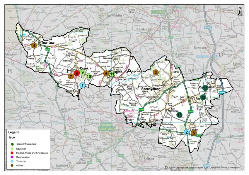
Infrastructure Delivery Plan June 2019

                                  Map 1 Monitoring Area Map

  1 Introduction
  What is the Infrastructure Delivery Plan?

  1.1 The Sustainable Community Strategy, Regeneration Statement and CDP set frameworks
  for the delivery of improvements to the economic, social and environmental conditions of
  communities across the county. The CDP sets out specific land allocations for future
  employment, housing and transport. The IDP identifies how, when and where the council
  and its partners will provide infrastructure needed to achieve the CDPs vision for growth.

4 County Durham Plan Infrastructure Delivery Plan June 2019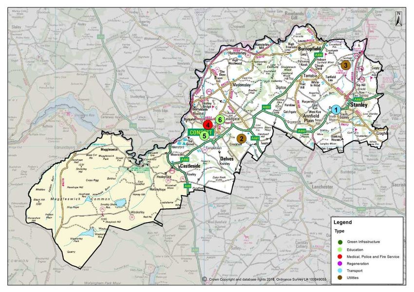
Infrastructure Delivery Plan June 2019

  National Planning Policy Framework (NPPF), 2018

  The NPPF published by the Ministry of Housing, Communities and Local Government
  states that local planning authorities must work with other providers to understand
  infrastructure needs and:

  Strategic policies should set out an overall strategy for the pattern, scale and quality of
  development, and make sufficient provision for:

  a) housing (including affordable housing), employment, retail, leisure and other commercial
  development;

  b) infrastructure for transport, telecommunications, security, waste management, water
  supply, wastewater, flood risk and coastal change management, and the provision of
  minerals and energy (including heat);

  c) community facilities (such as health, education and cultural infrastructure); and

  d) conservation and enhancement of the natural, built and historic environment, including
  landscapes and green infrastructure, and planning measures to address climate change
  mitigation and adaptation." (NPPF paragraph 20)

  Effective and on-going joint working between strategic policy-making authorities and
  relevant bodies is integral to the production of a positively prepared and justified strategy.
  In particular, joint working should help to determine where additional infrastructure is
  necessary, and whether development needs that cannot be met wholly within a particular
  plan area could be met elsewhere. (NPPF paragraph 26)

  Plans should set out the contributions expected from development. This should include
  setting out the levels and types of affordable housing provision required, along with other
  infrastructure (such as that needed for education, health, transport, flood and water
  management, green and digital infrastructure). Such policies should not undermine the
  deliverability of the plan. (NPPF paragraph 34)

1.2 The IDP supports a number of planning functions, it is an evidence base for the CDP
that helps to meet statutory requirements, supports delivery and investment programmes,
and indicates where private sector developers will be expected to contribute towards the
provision or improvement of local and strategic infrastructure. Where funding cannot be found
for infrastructure projects, shortfalls can be identified and used to inform negotiations
on planning obligations that will address infrastructure needs, subject to Section 106 test.
The IDP can also be used as a key evidence base when applying for funding from the Local
Enterprise Partnership or from other bodies.

                            Infrastructure Delivery Plan June 2019 County Durham Plan 5
Infrastructure Delivery Plan June 2019

  The Scope of the Infrastructure Delivery Plan

  1.3 The following types of physical, social and green infrastructure (GI) are included in this
  plan:

   Physical Infrastructure              Transport - Sustainable transport, walking, cycling, bus, rail
                                        and highways

                                        Utilities - Water management and energy

                                        Communications

   Social Infrastructure                Medical care

                                        Emergency services

                                        Education provision

   Green Infrastructure (GI)            Open space

                                        Playing pitches

                                        Footpaths and public rights of way

  Partnership Working

  1.4 The IDP has a broad role, as it helps inform service planning and capital investment
  decisions by infrastructure providers that have not traditionally been included in plan-making
  decisions. It recognises that planning is 'spatial' and helps to deliver services that play an
  important role in the fabric of communities such as schools, GP surgeries and public transport.
  The IDP focuses on infrastructure that is needed but not yet provided, particularly trying to
  develop a picture of different needs in different parts of the county so that investment can be
  used more effectively to address gaps.

  1.5 Partnership working underpins the development of the IDP. The 2019 version of the
  IDP forms part of the evidence base for the County Durham Plan Pre-Submission Draft 2019.
  There has been continuous engagement with delivery partners. The development of the IDP
  has involved close working with many organisations and it is hoped these relationships can
  continue to be built upon in the future in order to refine and improve infrastructure planning
  and continue to align infrastructure planning and investment decisions with the aims of spatial,
  community and corporate planning. We believe that the close working relationships formed
  with delivery partners has ensured our approach to spatial planning has gone well beyond
  the minimum requirements of Duty-to-Cooperate and can be viewed as a best practise
  approach to infrastructure planning.

6 County Durham Plan Infrastructure Delivery Plan June 2019
Infrastructure Delivery Plan June 2019

1.6 The IDP is a 'living document' that is updated periodically, its performance will be
monitored through annual monitoring reports. The current economic climate continues to be
challenging for some IDP stakeholders so this approach gives an opportunity to review
progress, identify funding priorities and gaps and make any necessary adjustments.

IDP Investment Schedules

1.7 The IDP Schedule is located at the end of every monitoring area section. The IDP
Schedule is the financial breakdown of investment in each monitoring area of the county, the
information is further divided by infrastructure type in line with the IDP main report. It is
important to note that the IDP is a 'living' document, therefore, projects and financial
information included could change as a result of a number of factors, including changes in
circumstance and additional planning applications.

1.8 The capital investments listed within the IDP schedule can be reviewed to reflect more
changing economic circumstances and/or changing priorities for the future. The information
in the IDP schedule is organised into three levels of priority:

                            Table 1 - Colour Coding In IDP Schedule

                          Committed capital programme/secure or ongoing developments

                          Uncertain capital available, scheme part funded or uncertain
                          timescales

                          Infrastructure required with no funding/longer term aspirations

2 County Durham Plan
2.1 The CDP will guide future development and growth in County Durham up to 2035 and
sets the framework for new development in the county; what is needed for our residents,
businesses and visitors, and where it should be located. The CDP includes:

    Objectives for the county, focusing on the key issues to be addressed;
    A strategy for delivering the objectives in the plan setting out the quantity of development
    required and the spatial distribution for development;
    An overall spatial interpretation of how the county and its towns and villages should
    develop;
    A number of site allocations for employment, housing and minerals developments; and
    Policies to set the basis for determining planning applications.

Proposed Housing Distribution in County Durham

2.2 The CDP includes a target for the delivery of at least 24,852 new dwellings using a
government standard methodology adjusted to take into account past actual performance
over the last 5 years. Full details relating to the future housing needs of the county can be
found in the 'Quantity of Development' chapter of the CDP.

                           Infrastructure Delivery Plan June 2019 County Durham Plan 7
Infrastructure Delivery Plan June 2019

  2.3 The Pre-Submission Draft sets out a distribution of housing to meet housing need
  based upon a dispersed pattern of development located in key settlements across the county
  and principally focused in and around the towns where the greatest opportunities for
  employment, services and facilities, public transport and other infrastructure such as healthcare
  and education exist. All future allocations and existing commitments have been shared with
  infrastructure providers as part of the development of the IDP. This information has informed
  investment decisions from organisations responsible for infrastructure including, utilities,
  health and public services.

                    Table 2 County Durham Plan Housing Allocations by Monitoring Area

           Settlement        Ref                                    Site                    Yield

                                      NORTH DURHAM MONITORING AREA

   Chester-le-Street       2/PE/11     Former Roseberry Comprehensive School                         65

                                NORTH WEST DURHAM MONITORING AREA

   Consett                 1/CO/89a    Former Blackfyne School                                      100

                           1/CO/89d    East of Muirfield Close                                       30

                           1/CO/42     South of Knitsley Lane                                       200

                           1/CO/16     Rosedale Avenue                                               50

                           1/CO/07
                           &            Laurel Drive                                                290
                           1/CO/08

                                      DURHAM CITY MONITORING AREA

   Durham City             4/DU/157    Gilesgate School                                              60

                           4/DU/118    North of Hawthorn House                                       20

                           4/DU/161    South of Potterhouse Terrace                                  10

                           4/DU/93     Former Skid Pan, Aykley Head                                  50

                           4/DU/101    Sniperley Park                                          1,700

                           4/DU/104     Sherburn Road                                               420

                                     CENTRAL DURHAM MONITORING AREA

   Bearpark                4/BE/01     Cook Avenue                                                  200

                           4/BE/06     Cook Avenue North                                             50

                                       MID DURHAM MONITORING AREA

   Crook                   3/CR/02     High West Road                                               250

   Spennymoor              7/SP/097    Former Tudhoe Grange Upper School, St Charles Road            85

                           7/SP/333    Former Tudhoe Lower School, Durham Road                      110

   Willington              3/WI/03      Land to east of Ash Drive                                   200

8 County Durham Plan Infrastructure Delivery Plan June 2019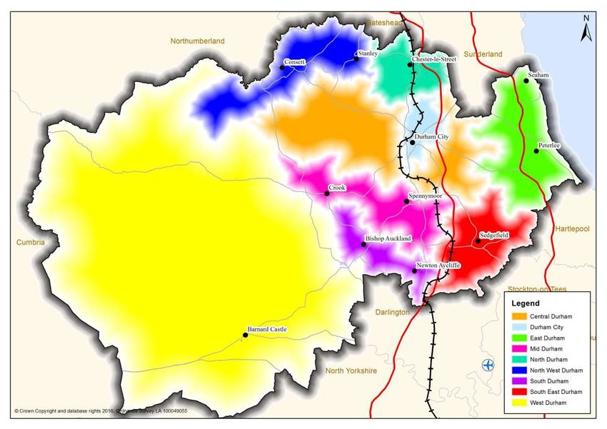
Infrastructure Delivery Plan June 2019

                             SOUTH DURHAM MONITORING AREA

Bishop Auckland   3/BA/21     Former Chamberlain Phipps                         75

                  3/BA/31a    Bracks Road                                       50

Newton Aycliffe   7/NA/313    Copelaw                                           600

                  7/NA/005    Eldon Whins                                       80

                  7/NA/326    Land at Woodham College                           100

                  7/NA/186     Cobblers Hall                                    50

                       SOUTH EAST DURHAM MONITORING AREA

                             EAST DURHAM MONITORING AREA

                  5/PE/01a
Peterlee                       North Blunts                                     65
                  5/PE/01b

Seaham            5/SE/09     Seaham Colliery                                   335

                  5/SE/21     Former Seaham School                              95

                             WEST DURHAM MONITORING AREA

Wolsingham        3/WO/20     Land off Leazes Lane                              40

                       Infrastructure Delivery Plan June 2019 County Durham Plan 9
Infrastructure Delivery Plan June 2019
Employment Land
2.4 The Employment Land Review (ELR) has been carried out and provides the principal
evidence to determine the amount of employment land that is needed across the County.
Following consultation with commercial agents, land owners and developers, the ELR has
identified six distinct commercial property markets:
Durham City;
A1 Corridor;
A19 Corridor;
Consett and surrounds;
Bishop Auckland and surrounds; and
The rest of County Durham including rural areas.
2.5 Countywide: The A1 Corridor stretches the length of the county from Chester-le-Street
in the north to Newton Aycliffe in the south. It covers the area immediately accessible to the
A1(M) and its attractiveness as an office and industrial location is linked to its proximity to
the strategic road network. It includes many of the county’s key employment locations such
as Drum Industrial Estate near Chester-le-Street, Aycliffe Business Park in Newton Aycliffe
and NETPark at Sedgefield.
2.6 North West Durham incorporates the towns of Consett and Stanley and their
surrounding hinterlands. The area generally serves a more localised market, however
significant employment areas are evident at Hownsgill, Consett Business Park and Number
One in Consett and the estates at Greencroft and Tanfield Lea around Stanley and Annfield
Plain.
2.7 North Durham includes the town of Chester-le-Street with the successful Drum Industrial
Estate located immediately north of the town. This estate has seen high take-up over the
past 15 years and benefits from its proximity to the A1(M) and the improved local road network.
2.8 Durham City is recognised as the county’s pre-eminent office location, reflecting the
city’s potential to improve its attractiveness to a diverse range of occupiers in the future. The
city centre and businesses parks within the town represent a distinct offer within the county.
The Aykley Heads site forms a prominent, high profile, gateway site, within close proximity
of Durham Railway Station. This provides high speed rail links through its connections on
the East Coast Mainline. It also has excellent road links to the A1(M) and the A167. The
recent investment by Atom Bank is evidence to the market attractiveness that exists at Aykley
Heads and within Durham City.
2.9 Central Durham incorporates Meadowfield and Littleburn industrial estates, located
to the west of Durham City. These cover a large area and house a variety of businesses and
uses. Land exists at the popular Meadowfield Industrial Estate and Integra 61 at Bowburn
for further business and industrial growth building on locational advantages.
10 County Durham Plan Infrastructure Delivery Plan June 2019Infrastructure Delivery Plan June 2019
2.10 Mid Durham includes the settlements of Spennymoor, Crook and Willington. Each
of these towns have their own industrial areas which serve important markets. Spennymoor
retains national firms such as Thorn, whilst the industrial estates at Crook and Willington
meet more local needs.
2.11 South Durham is home to the large industrial areas around Newton Aycliffe. The
recent arrival of Hitachi has brought multiple benefits to the area. Merchant Park is the base
for Hitachi train manufacturing and assembly plant, whilst a further site Forrest Park, has
also been identified as a site for further investment, building on the success of the Hitachi
investment. This site has seen funding secured to improve utility infrastructure and there is
also potential to consider a major rail freight interchange operation. Elsewhere within South
Durham the towns of Bishop Auckland and Shildon will continue to meet local business needs
within the area.
2.12 East Durham is located within the heart of the prominent A19 Corridor market area.
This stretches the length of county’s east coast from the county’s border with Sunderland in
the north, to the Hartlepool border in the south. Large industrial areas and business parks
exist around the towns of Peterlee and Seaham which provide significant employment
opportunities within this area of the County. To the south of Murton is the site of the proposed
Jade Park which has recently been unveiled by the North East LEP as one of ten sites around
the region that will be given Enterprise Zone status.
2.13 South East Durham is home to NETPark located to the north of Sedgefield. NETPark
is one of the UK’s premier science, engineering and technology parks for the commercialisation
of cutting edge research and development from major international organisations. Land exists
to the north of the estate to extend the site further over the Plan period and fulfil phase 3 of
the materplan.
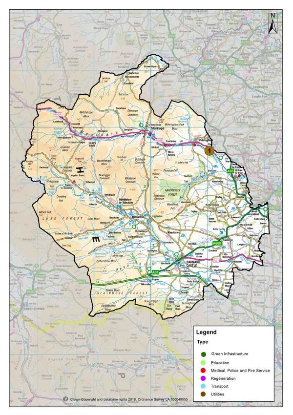
2.14 West Durham is largely rural with Barnard Castle acting as the main service centre
and the principle focus for employment. It contains a major industrial facility operated by
Glaxo Smith Kline (GSK). Whilst GSK represent a major international occupier, Barnard
Castle largely provides a modest level of industrial floorspace which is occupied by small
local businesses. The rural service centres such as Wolsingham, Stanhope and Middleton
in Teesdale also cater for local business needs.
2.15 The CDP has the following allocation for employment land across the County;
Table 3 County Durham Plan Employment Site Allocations
Central Durham Delivery Area Site Area (hectares, net)
Integra61 (Land South of Bowburn Road) 44.25
Meadowfield Estate 26.67
Bowburn North Industrial Estate 0.42
Total 71.34
Durham City Delivery Area Site Area (hectares, net)
Infrastructure Delivery Plan June 2019 County Durham Plan 11Infrastructure Delivery Plan June 2019
(ii)
Aykley Heads (B1 only) 3.0
Dragonville 1.18
Belmont Industrial Estate 5.48
Abbey Woods 0.66
Total 10.32
East Durham Delivery Area Site Area (hectares, net)
Jade Park 18.85
Peterlee North West Industrial Estate 8.52
Peterlee South West Industrial Estate 8.2
Sea View Industrial Estate (Horden) 1.6
Total 37.17
Mid Durham Delivery Area Site Area (hectares, net)
Chilton Industrial Estate 0.76
Chilton Extension 3.42
Dean and Chapter Industrial Estate (Ferryhill) 0.23
Green Lane Industrial Estate / Durham Gate (Spennymoor) 10.18
Low Willington Industrial Estate 11.16
Inkerman 1.16
Dan's Castle Industrial Estate (Tow Law) 0.26
Total 27.17
North Durham Delivery Area Site Area (hectares, net)
Drum Industrial Estate (Chester-le-Street) 4.44
Stella Gill Industrial Estate (Chester-le-Street) 1.29
Westline Industrial Estate 1.01
Bowes Buisness Park (Lambton) (B1 only) 0.17
Lambton Estate 10.04
Total 16.95
ii excludes areas that are currently in use for employment
12 County Durham Plan Infrastructure Delivery Plan June 2019Infrastructure Delivery Plan June 2019
North West Durham Delivery Area Site Area (hectares, net)
Villa Real (Consett Business Park) 0.78
Delves Lane South 0.61
Leadgate Industrial Estate 1.06
Tanfield Lea Industrial Estate (North) 1.9
Tanfield Lea Industrial Estate (South) 2.13
Greencroft Industrial Estate (Annfield Plain) 5.66
Number One Industrial Estate (Consett) 1.37
Total 24.31 (includes 10.8 hectares
on Hownsgill Industrial
Estate)
South Durham Delivery Area Site Area (hectares, net)
Aycliffe North 10.19
Aycliffe South 11.09
Merchant Park (Newton Aycliffe) 10.12
Forrest Park (Newton Aycliffe) 50.85
South Church Enterprise Park (Bishop Auckland) 6.86
St Helens Auckland 2.46
Future Business Park (Shildon) 2.74
All Saints Industrial Estate (Shildon) 6.72
Total 101.03
South East Durham Delivery Area Site Area (hectares, net)
Fishburn Industrial Estate 0.82
Total 0.82
West Durham Delivery Area Site Area (hectares, net)
Harmire Industrial Estate (Barnard Castle) 2.32
Stainton Grove Industrial Estate 0.2
Land at Shaw Bank (Barnard Castle) 7.13
Infrastructure Delivery Plan June 2019 County Durham Plan 13Infrastructure Delivery Plan June 2019
Randolph Coke Works (Evenwood) 2.78
Total 12.43
County Durham Total 301.54 (Includes 10.8
hectares on Hownsgill
Industrial Estate)
2.16 In addition a site of 13.5 hectares at land north of NETPark, Sedgefield is allocated
for uses with use class B1, specifically for Research and Development only alongside an
area of 17.69 hectares to the north of NETPark allocation which is safeguarded for future
expansion beyond the end of the Plan period. Further to this a site of 61.95 hectares to the
west of the Integra61 allocation is safeguarded for future expansion land beyond the end of
the Plan period.
14 County Durham Plan Infrastructure Delivery Plan June 2019Infrastructure Delivery Plan June 2019
3 Monitoring Areas
Countywide
Countywide Physical Infrastructure
Transport
Walking and Cycling Infrastructure
3.1 Local travel options will continue to be promoted through ongoing improvements to the
existing local cycle and footpath networks as well as the existing National Cycle Network
and other promoted routes. The IDP will set out key sections where we are prioritising
investment. The transport section of the Schedule sets out where investment is already
happening with regard to priority routes such as the Great North Cycle Way.
3.2 A process of Strategic Cycling Network Planning is being developed through the Cycling
Network Planning process and will be articulated in the Local Cycling and Walking
Infrastructure Plan (LCWIP) . This will set out the priority for investing in the cycling network.
The LCWIP will supplement the Strategic Cycling and Walking Delivery Plan for County
Durham 2018-28. A key element to encouraging cycling is the provision of high quality cycle
parking facilities. We have been working with ParkThatBike to install 400 stands throughout
the county over the last two years.
3.3 Walking and cycling infrastructure in County Durham is delivered by the Council (with
inter-connecting routes delivered by neighbouring authorities), Sustrans, public and private
landowners (e.g. Forestry Commission, individuals), environmental organisations and trusts
(e.g. Groundwork), private developers and partnerships (e.g. Area Action Partnerships).
Good communication between partners is essential to create a comprehensive and well
delivered and maintained physical network of paths and routes. Maintenance is covered by
several service areas within the council. The Railway Paths are managed by the Countryside
Service, Public Rights of Way are managed by the Public Right of Way (PROW) Team and
cyclepaths which are part of the highway are managed by the Highways Maintenance Team.
Rail Network
3.4 The rail network is owned by Network Rail with services operated by franchised or
open access train operators, but the council retains an active interest as an investment partner
in services and rail infrastructure as local and long distance rail provide a key strategic
opportunity to support and stimulate economic growth, linking businesses with each other
and people with jobs.
3.5 With stations on the East Coast Main Line corridor at Durham City and Darlington (for
communities in the south of the County), County Durham benefits from regular direct fast
links to Newcastle, Edinburgh, Glasgow, Manchester, Liverpool, London the West Midlands
and the South West.
3.6 There are however severe capacity constraints arising on the ECML in part from the
mix of traffic types in particular high speed passenger and slow moving freight on the two
track railway north of Northallerton. Currently, trains of similar speeds are ‘flighted’ (ie run
Infrastructure Delivery Plan June 2019 County Durham Plan 15Infrastructure Delivery Plan June 2019 together) north of York to maximise capacity which prevents an even spread of passenger services through the hour. The reinstatement of the Leamside Line would be a strategically important piece of transport infrastructure for the North East relieving the existing two track railway between Darlington and Newcastle. It could also enable a number of potential new stations in the council area, for example, at Ferryhill, Belmont Park and Ride and Fencehouses. 3.7 The council fully supports the re-opening of the Leamside Line and participates in the East Coast Main Line Authorities (ECMA) group to lobby for increased capacity on the corridor north of York so that the ECML in this area can accommodate HS2 and also the specification set out by Transport for the North (TfN) in the their vision for Northern Powerhouse Rail (NPR). 3.8 The local rail network comprising the Darlington to Bishop Auckland line (‘The Bishop line’) and the Durham Coast Line through Seaham is operated under the Northern Franchise. This, along with the Transpennine Franchise, is subject to devolution arrangements by which TfN share responsibility for the awarding franchises along with the Department for Transport. 3.9 The rail station estate, comprising 7 stations in County Durham are owned by Network Rail but leased and operated by the train service franchisees. A new station on the network at Horden to serve greater Peterlee is due to be completed and operational by the end of 2020. 3.10 Currently, rail freight services that start and finish in County Durham are limited. At the time of writing, there are no inter-modal freight terminals or major rail freight generators. However, the CDP has identified a potential site at Newton Aycliffe (Forrest Park) that has the potential to provide a site for the first major inland rail freight interchange in the north east and to create thousands of jobs associated with the growth of manufacturing. 3.11 The council has also been in dialogue with Nexus, operators of the Tyne and Wear Metro about their Metro Strategy and plans for refurbishment and extension of the network. The council considers carefully where these proposals may impact on the heavy rail network. 16 County Durham Plan Infrastructure Delivery Plan June 2019
Infrastructure Delivery Plan June 2019

               Map 2 Railway Lines, Stations and Opportunities in County Durham

Bus Improvements

3.12 Buses provide the only form of public transport in most parts of County Durham,
reflecting the limited number of railway stations in the county with 22.9 million passenger
journeys starting at bus stops in County Durham in 2016/17. There is an extensive network
of services throughout the county with approximately 175 services in the main network plus
additional services running only at school times. Over 3,000 stops are served. Most settlements
in County Durham have at least 2 buses per hour during Monday to Saturday daytimes, with
much higher frequencies in the main towns and along many of the main interurban corridors.
While in the more rural areas services may run every hour or less often, all but the smallest
settlements have regular services. However, the settlement pattern of towns and 229 villages
leads to some dispersed travel patterns that almost inevitably are not feasible by public
transport.

3.13 Providing an effective bus service requires a successful partnership between the
council and bus operators. The council invests in local bus services in two ways.

3.14 Firstly, the council helps to maintain an environment to enable bus operators to provide
reliable, attractive and accessible bus services that to a large degree are financially viable
on the basis of income from passengers. This includes the provision of bus-related
infrastructure such as bus stations, bus stops and shelters, bus priority lanes, supplemented

                           Infrastructure Delivery Plan June 2019 County Durham Plan 17
Infrastructure Delivery Plan June 2019 by softer measures such as comprehensive integrated information and consideration of bus service accessibility within the planning process. The council owns and manages 5 off street bus stations with 4 principal and several smaller on street interchanges. 3.15 Secondly, the council also plays an important role in ensuring that the overall bus network meets the needs of the community, including under-pinning the operation of about 15% of the network where there is insufficient demand to make the services viable on a purely commercial basis, though contracts with bus operators. The 2016/17 budget for funded services is approximately £2.7m. The supported services include routes operating across the council’s boundaries to ensure comprehensive bus links with key destinations in adjoining areas, with joint funding arrangements with the neighbouring authorities where possible. 3.16 Approximately 92% of passengers are carried on bus services operated on a purely commercial basis, where the operators determine the routes, timetables and fares. Go North East and Arriva are the principal operators in County Durham, supplemented by several smaller operators which provide locally important services. The smaller operators provide a larger share of the services operating under contract to the council. All of the bus operators are responsible for their own investment in their bus fleet and depots, although the council continuously assess funding opportunities which may help operators contribute to 'greening' the bus fleet. 3.17 The location of new developments has a significant influence on travel patterns and the degree to which they can be effectively served by commercially successful bus services. The identification of sites for housing and other developments in the County Durham Plan has sought to take account of accessibility by bus services as a key consideration. The council will continue to work in partnership with bus operators to inform them of the location and scale of proposed developments. This will enable operators to build new or enhanced services meeting these new passenger demands into their own investment plans as sites come forward. Where it is apparent that additional action is required to ensure good accessibility for bus users, perhaps due to transitional effects during phased build outs (but not limited to this reason), developers will be required to provide improvements to bus services and/or infrastructure as part of planning agreements. Section 106 funding will continue to be secured on individual sites where appropriate. Highways 3.18 The majority of people in County Durham are reliant on road infrastructure for transport. The highway network can be broadly separated into the Strategic Road Network (SRN) and the Local Road Network (LRN). However, in the future, it is likely that the government will identify a Major Road Network (MRN) which will consist of the most used A-Roads in the County. These are currently classified as being part of the LRN as they are in local authority ownership. Strategic Road Network: Highways England has responsibility for maintaining and improving the Strategic Road Network (SRN). In County Durham, this includes the A19, A66 and the A1(M). The A1(M) motorway is one of the county's most important economic assets in terms of facilitating strategic access to, from and within the central corridor of County Durham. It provides the nationally significant north-south link connecting the county and the north east 18 County Durham Plan Infrastructure Delivery Plan June 2019
Infrastructure Delivery Plan June 2019

with the south of England and Scotland. Newton Aycliffe, Spennymoor, Durham City and
Chester-le-Street are all located in close proximity to this nationally important economic and
transport corridor.

3.19 The A19 provides a north-south link through the east of the County linking Peterlee
and Seaham to Tyne and Wear and Tees Valley.

3.20 The A66 is located in the south of the county and provides Barnard Castle with nearby
access to the A66 and then an east-west link to the A1(M) at Scotch Corner and the M6 at
Penrith. The A66 provides the key strategic route for County Durham and Teeside to link to
the Lake District and the North West of England at Penrith and Tebay (via the A685). Transport
for the North (TfN) are proposing upgrades to the A66 to duel areas to the west of the county.

                     Map 3 Populations of Main County Durham Settlements

Impact of County Durham Plan (CDP)

3.21 Highways England (HE) have considered the employment and housing allocations
presented by the council in the pre-submission version of the plan. As was their position at
the preferred options stage of the CDP in 2018, Highways England have confirmed that traffic
growth associated with the CDP is not a concern as the growth is within the levels that would
have been forecast by TEMPRO and less than the traffic growth modelled in relation to the

                           Infrastructure Delivery Plan June 2019 County Durham Plan 19
Infrastructure Delivery Plan June 2019
withdrawn plan in 2014 (where HE offered no objection). With lower housing targets now set
for the pre-submission version of the CDP, when compared to the Preferred Options, HE do
not object to the impact of the County Durham Plan on the Strategic Road Network.
3.22 Cross Boundary Issues
3.23 Regional priorities for investment in the SRN across the wider North East were set in
the national Roads Investment Strategy (RIS) 2015/16-19/20, which was informed through
the process of preparing Route Strategies in consultation with Local Authorities and other
stakeholders. The RIS sets out the Government's Strategic Vision and Action Plan for
Highways England and the approach to maintaining, operating and improving the SRN in
England. The RIS includes an Investment Plan that focuses on tangible improvement’s to
the network and outlines how Highways England will invest in the SRN between 2015/16
and 2020/21. Work on RIS 2 which will cover the next 5 years from 2021 is now well underway.
3.24 The key asks of the RIS will be among some of the strategic infrastructure highlighted
in the forthcoming Transport for the North Strategic Transport Plan (STP). The statutory
st
status of Transport for the North came into effect on the 1 April 2018. As a result, TfN is
now a Sub National Transport Body and has the responsibility to write the STP for the North
of England. This plan will set out proposals for major road and rail infrastructure across the
North as well as introducing a standard method for smart ticketing. Officers from the LA7
have been working together with TfN to identify appropriate transport investment proposals
as well as identifying appropriate A roads that should be classified as part of the Major Road
Network (MRN). A final plan is expected to be adopted early in 2019 alongside a
complementary investment programme detailing the interventions and timescales, derived
from TfNs 'multi modal corridor studies'.
3.25 Map 3 shows that the county's population centres are close to the SRN which are
coloured blue. The map also shows the major local roads in County Durham.
3.26 The Local Road Network in County Durham: The council has responsibility for
maintaining the local road network as well as making improvements in line with the Local
Transport Plan for County Durham. The A-road network through the county supplements the
longer distance role of the strategic north-south routes through the county as well as providing
east-west and more localised connectivity to services and employment. These 'A' roads are
known as 'economic/transport corridors' in LTP3.
3.27 The prinicipal A-roads (excluding SRN roads) in County Durham are:
A690 provides linkage between Durham City and Sunderland in the east and Crook and
Mid Durham in the west;
A691 provides connectivity from Consett in North West Durham and into Durham City;
A692 provides connectivity to/from Tyne & Wear for North West Durham'
A693 is the main lateral corridor in the north of the county, linking Consett, Stanley and
Chester-le-Street,
20 County Durham Plan Infrastructure Delivery Plan June 2019Infrastructure Delivery Plan June 2019
A167 forms a corridor between Chester-le-Street in the north and Newton Aycliffe in the
south of the County linking with a number of the other A-roads and Durham City;
A177 links Sedgefield and NETPark to the A1(M);
A66 is a key route to Cumbria in the south west of the county, connecting locally with
Darlington and the TeesValley;
A68 has a tourist role to/from the Scottish Borders and links Consett and Tow Law to
the west of the county as well as linking the County with Northumberland;
A688 is the main corridor linking the A1(M) with Mid Durham, South Durham and rural
Teesdale whilst providing access to the A66, A68 and A167;
A689 is the main lateral corridor connecting south East Durham, South Durham and
serving rural Weardale as well as linking with Teeside and Cumbria; and
A694 is a key route from Consett into Newcastle via Rowlands Gill.
3.28 With County Durham being predominantly rural, there are also some significant B
roads that play an important social role and supporting role to the transport/economic corridors
within County Durham, especially roads that link settlements in the rural west.
3.29 With the emergence of the North of the Tyne Combined Authority (NTCA) in 2018,
the Joint Transport Committee (JTC) will now oversee a North East Transport Plan and
coordinate strategic transport decisions for both the North and South of the Tyne Combined
Authorities. However, they will delegate back to the council the powers to continue managing
local public transport services including managing the road network and parking requirements
in the County.
3.30 A ‘Transport Manifesto – Our Journey’ has been developed by the NECA (a
consultation took place between February and April 2016) which will feed into the development
of the Local Transport Plan for the North East Combined Authority.
Junction/Highways Improvements
3.31 The IDP highlights major and minor junction improvements that are required around
the county to facilitate development growth. The individual schemes are listed in each
monitoring area while there is more detail around the major SRN junction improvements in
each monitoring area.
3.32 In the Durham City monitoring area, we have provided a longer list and additional
detail regarding transport improvements that are essential for delivering the sustainable urban
extension housing sites in Durham City. This is to help provide clarity on some of the critical
local highway improvements that will need to accompany the Western Relief and the Durham
City Sustainable Transport Delivery Plan 2016-33 (DCSTDP 2019-35) - which includes the
Northern Relief Road. The DCSTDP also provides some principals for a range of sustainable
Infrastructure Delivery Plan June 2019 County Durham Plan 21Infrastructure Delivery Plan June 2019
transport projects across the city. The DCSTDP sets out how modal shift can be practically
achieved in the city by identifying packages of demand management and infrastructure
improvements to achieve modal shift .
3.33 The localised impact of traffic growth linked to all allocations in each settlement has
though been assessed by the authority's highway officers as part of the site allocation process.
Where local site access cannot be achieved, SHLAA housing sites have not been taken
forward to allocations.
3.34 The council has commenced a 6 year project to replace 55,000 street lights across
the county with state-of-the-art LED lights. The lights are environmentally friendly and cheaper
to run and will see carbon emissions from street lights which are part of the project reduced
by 73% and save around £24m over a 25 year period.
Water Management
3.35 A critical component of the infrastructure required to support new development is
associated with water; the provision of clean water for domestic drinking and washing and
industrial processes; the safe disposal of wastewater; and protection from flooding. In County
Durham, the key issue relating to water infrastructure and strategic planning, is the timing of
Northumbrian Water's (NWL) investment in Sewage Treatment Works (STWs).
3.36 There are three key organisations involved in water management in County Durham,
including NWL, the council as lead local flood authority, and the Environment Agency. As a
key part of the Infrastructure planning process, the three organisations above have been
working together on the The Water Cycle Study (WCS), which includes a Surface Water
Management Plan and the Strategic Flood Risk Assessment. The WCS assesses the potential
impacts of growth on:
Water supply;
Water sewerage treatment plants;
Water quality; and
Surface water flooding.
3.37 Impact of development on water resources and water supply network: NWL has
two Water Resource Zones (WRZ); Kielder WRZ and Berwick WRZ. County Durham falls
within the Kielder WRZ which is not forecast to experience a deficit in water resources or
water supply in the long term. The River Wear and Tees are regulated by the presence of
Kielder Water; Northern Europe’s largest man-made lake which has capacity to hold
200,000ML of water. The Kielder Water Scheme allows transfers to be made between the
major north east catchments and allows water resources to be used to a fuller extent if and
when needed. In addition there is also Derwent Reservoir within the county. There is sufficient
resource in the WRZ to address future demand.
3.38 In terms of the supply network, NWL has reviewed the CDP housing allocation sites.
Investment will be required to address poor water pressure and getting water to sites at a
higher elevation.
22 County Durham Plan Infrastructure Delivery Plan June 2019Infrastructure Delivery Plan June 2019
3.39 Impact of development on sewerage treatment works (STW): Due to the large
geography of County Durham the provision of STWs is one of the major infrastructure
challenges in the county. There are around 70 water sewerage treatment plants in the County
as well as an extensive river network. As part of the WCS, NWL provided the catchment
areas for each of their STWs which enabled the forecast housing development to be grouped
by STW so that the cumulative impact of development could be evaluated.
3.40 Water quality: There are a number of watercourses across County Durham that are
currently failing EU Water Framework Directive (WFD) targets and are at risk of not achieving
WFD objectives. The reason for the failures may in part be because of discharges from STWs
and the Environment Agency has a programme of measures to improve these watercourses.
As part of the partnership approach to the Plan, the EA and the council are now aligning
investment plans to implement GI Frameworks to improve water quality on any water courses
in close proximity to large allocations.
3.41 Surface water: Flooding from surface water presents a risk across County Durham,
particularly in the urban areas. New developments present the best opportunities to manage
the risk of surface water flooding - particularly the development of combined sewer networks.
The Water Management Policy of the CDP seeks to protects and enhance the water
environment, making prudent use of water resources and encouraging the use of Sustainable
Urban Drainage System (SUDS). The Water Management Policy in the CDP has been used
by NWL as an example of best practice policy.
3.42 Investment Planning: The Current investment plan being used by NWL is called
AMP6 and runs from April 2015 to March 2020. The council have been working closely with
NWL to influence the investment planning for the current plan period. The priorities for AMP
6 are set out in this document. AMP 6 has been agreed with the water regulator (OFWAT)
and the investment priorities of NWL reflect the development aspiration and allocations of
the CDP. This is a direct result of the partnership working between Durham County Council,
Northumbrian Water Ltd and the Environment Agency as part of the IDP and the WCS.
3.43 £80m of AMP6 which will focus on improvements to the sewage and drainage network
(see the IDP schedule). The council will work in partnership with NWL to highlight when
development sites are coming forward to help influence NWLs investment schedule.
Broadband
3.44 Digital technologies are becoming increasingly important for modern living and working
practices, and access to high speed, reliable broadband is now considered a necessity for
many people.
3.45 An effective broadband network is vital for businesses to support economic growth
and efficiencies, and to allow them to compete in a global market. Equally, the social benefits
are vast and have the potential to transform many aspects of people’s lives – from education
to entertainment, and improving the opportunities for employment through flexible and remote
working. Good broadband services can also facilitate access to a broad range of public
services, making them more available, convenient and cost effective.
Infrastructure Delivery Plan June 2019 County Durham Plan 23Infrastructure Delivery Plan June 2019 3.46 Digital infrastructure isn’t built without foresight, planning, investment and innovation. Whilst the network is largely delivered and managed by private sector telecommunications providers, the Digital Durham programme has been in place since March 2012 aiming to improve the availability of Next Generation Access (NGA) broadband to areas outside of any commercial plans. 3.47 Led by the council, Digital Durham encompasses nine other North East local authority areas; Gateshead Council, North Tyneside Council, South Tyneside Council, Sunderland City Council and the Tees Valley Combined Authority covering the five Tees Valley councils. 3.48 Under the programme, the council is working in partnership with the UK Government and aforementioned local authorities to help improve broadband speeds for residents and businesses through several broadband and digital initiatives. 3.49 Central to the programme has been the award of two contracts, collectively worth £35 million, to supplier British Telecom (BT) to extend fibre infrastructure to as many businesses, homes and communities in the region as possible with the funding available. In terms of County Durham alone, £15.86 million worth of public funding is being jointly invested by the council and Government, as well as an additional capital outlay by BT. 3.50 The rollout has focused on upgrading exchange buildings and expanding the physical fibre network. As of May 2018, the programme has enabled more than 700 fibre structures and rolled out approximately 650km of fibre. By the end of Phase two in 2018, more than 112,000 properties across the programme area can benefit from a superfast broadband service if they upgrade through an Internet Service Provider. 3.51 By April 2018, the take up of fibre-based broadband services to properties supplied through infrastructure installed under Contract One of the programme was more than double the UK Government target of 20% - a clear indication of the demand for faster broadband speeds. 3.52 At the end of 2017, 96% of homes and businesses in County Durham have access to superfast broadband speeds of 24Mbps or more, which is slightly ahead of the UK Government target of 95%. 3.53 The programme plans to continue to extend NGA coverage using the available funding. One of the key challenges is to improve broadband services to the remaining properties that are scattered over a wide geography in remote and isolated areas of the County, with no underground duct or overhead infrastructure to enable fibre cables to be readily extended. However, technology continues to develop and other options to fixed line broadband services may also be considered in the future. 3.54 The CDP will facilitate the development of additional residential and non-residential properties, which is likely to drive demand for broadband. Most businesses will demand a good standard of broadband, and ideally new commercial property will be primarily developed in and around larger towns and villages which are more likely to have access to the existing fibre network. New developments are outside of the scope of the Digital Durham programme and it is the responsibility of the developer to organise the provision of fibre to a site. Direct fibre access is the most ‘future-proof’ option and the council will require developers to include this provision to properties on new build or major site renovations. Exceptions may be made 24 County Durham Plan Infrastructure Delivery Plan June 2019
Infrastructure Delivery Plan June 2019

in circumstances where applicants must show through consultation with broadband
infrastructure providers, that this would not be possible, appropriate, practical or economically
viable.

3.55 As a complement to these services, the council's Digital and Customer Service
Infrastructure Team support the council’s telecommunications networks and provide a range
of services to external organisations. This includes over 600 schools, NHS hospitals, police
and fire services and a number of community and third sector organisations. A set of service
level agreements are in place to support network provision, Internet services, digital security
measures and communications systems that underpin the activities of these important
services.

Mobile Communications

3.56 The planning for mobile communications infrastructure is largely market driven by the
various mobile operators and providers. However, the council refers to and complies with
the Code of Best Practice on Mobile Network Development in England. The code has been
developed by Arqiva, Historic England, the Mobile Operators Association, National Parks
England and the Planning Officers Society. The code has been developed in line with the
NPPF and the council has ensured that proposed policies in the CDP are consistent with
section 10 (supporting high quality communications) of the NPPF.

Energy

3.57 Northern Powergrid is responsible for delivering electricity to homes across County
Durham and Northern Gas Networks is responsible for delivering gas. The county has 27
primary electricity sub-stations which have enough power to supply 12,000 homes, secondary
sub-stations spread across the county provide at a very local level for around 400 homes.
The gas network includes pipelines that supply premises across the county.

3.58 The scale of development proposed in the CDP does not concern Northern Gas
Network or Northern Powergrid. Work has been ongoing with Northern Powergrid to identify
requirements for larger allocations proposed across the county and details are included in
the funding schedules.

3.59 There is a continuing emphasis for energy suppliers to make the transition to renewable
energy sources as well as the development of new technology that supports it. More energy
efficient home appliances and the ongoing economic downturn are combining to reduce
overall demand for energy. Other energy challenges include:

    The growing use of photovoltaic and small-scale wind turbines to generate energy means
    electricity sub-stations need to be upgraded to enable them to manage supply and
    demand in changing weather conditions and different times of the day;

    In some areas, particularly those without gas, there is growing use of heat pumps which
    use electricity to generate heat and can lead to power surges, especially during mornings;

                            Infrastructure Delivery Plan June 2019 County Durham Plan 25
Infrastructure Delivery Plan June 2019
A surge in the demand for electric vehicles could also lead to the need for significant
infrastructure upgrades. This is needed in order to respond to additional demands for
electricity which may contrast with traditional consumption patterns (e.g. growing demand
at traditional off-peak times of the day); and
In County Durham large-scale wind energy developments are unlikely to continue on
the same scale as in the last 5 years because of constraints on remaining sites.
Electric Vehicles
3.60 For both economic and environmental reasons it is important to assist the development
of the low carbon economy. An element of this new economic outlook is looking to more
sustainable travel and support for a growing market for electric vehicles in the region. As part
of this approach, the provision of electric charging points within the public realm needs to be
pursued to provide the essential confidence for drivers arising from range anxiety.
Regeneration Masterplans
The council, Area Action Partnerships and partners will continue to prioritise town centres
including the retail sector support and key public realm improvements through the preparation
of updated Masterplans for the larger towns. The Masterplans will contain detailed information
relating to specific regeneration programmes and initiatives including physical and social
regeneration programmes being implemented across the Masterplan area, as such this
information is not included within the IDP.
Countywide Social Infrastructure
School Places
3.61 There are 268 schools in County Durham and one Pupil Referral Unit that provides
education for pupils permanently excluded from mainstream school:
30 Secondary Schools (including 17 Academies);
1 Sixth Form Centre;
10 Special Schools;
194 Primary Schools (including 18 Academies);
10 Junior Schools (including 2 Academy);
10 Infant Schools (including 1 Academy); and
11 Nursery Schools.
26 County Durham Plan Infrastructure Delivery Plan June 2019Infrastructure Delivery Plan June 2019
3.62 Primary school pupil numbers are projected to increase slightly from 2018 to 2020.
From 2021 numbers are expected to remain constant until 2027 whereupon they are expected
to increase to 2032. By 2032 there is expected to be in the region of 1,800 more primary age
pupils than there are in 2018. Secondary school numbers (11-16) are projected to increase
each year from 2018 – 2023. From 2023 numbers are expected to fluctuate each year to
2032. In 2023 there are expected to be approximately 750 more secondary age pupils than
there are in 2018. However these increases do not take account of future housing
developments which are likely to be built over the next 15-20 years to respond to the council’s
aspirations to make County Durham a prime location for business to enable a thriving economy
for the county. This will have a significant impact on the future pattern and provision of school
places. While it is not cost effective to maintain large numbers of surplus places in schools,
local authorities cannot and should not try to eliminate all surplus capacity. A certain level of
surplus places is necessary because:
It allows greater opportunity to respond to parental preference;
There may be unpredicted changes to demographic patterns, with a sudden influx of
children to particular areas; and
There may be unexpected changes to house building patterns.
3.63 There is no single 'ideal' level of overall surplus capacity, since this varies from authority
to authority. It is reasonable to aim for between 5% and 10% overall surplus across the
authority. Patterns show that a reasonable figure for urban areas is around 5% whereas in
more rural areas it is around 10%. It is recognised that in some rural areas in County Durham
it may be difficult to achieve this target. Future capital investment in schools will reflect
Government initiatives; any additional funding will be used to improve the condition and
suitability of buildings and the provision of additional school places where required.
3.64 The County Council has an agreed admission policy for primary and secondary
education, along with an appeals process, details are available on the County Council website
(DCC Admission Policy).
County Durham and Darlington NHS Foundation Trust
3.65 County Durham and Darlington NHS Foundation Trust have 8 hospitals covering
County Durham, which are as follows;
Darlington Memorial Hospital, University Hospital of North Durham (Durham City),
Bishop Auckland Hospital, Chester-le-Street Community Hospital, Shotley Bridge
Community Hospital, Sedgefield Community Hospital, Richardson Hospital (Barnard
Castle) and Weardale Community Hospital (Stanhope)
3.66 Whilst hospitals do serve catchment areas, they also specialise in certain clinical
areas e.g. University Hospital of North Durham specialises in stroke, whereas James Cook
Hospital based in Middlesbrough specialises in cardiac and therefore patients diagnosed
with a condition may not be taken to nearest hospital but the one with the most appropriate
specialism.
Infrastructure Delivery Plan June 2019 County Durham Plan 27You can also read