Draft - An Archaeological Assessment of the Proposed Kaihu Valley Trail for the Kaipara District Council
←
→
Page content transcription
If your browser does not render page correctly, please read the page content below
An Archaeological Assessment
of the Proposed Kaihu Valley Trail
 for the Kaipara District Council

     f        t
  ra
D

  Michael Taylor & Tore Kronqvist
    ARCHAEOLOGY NORTH Ltd
     P.O. Box 7294, Whanganui

             July 2021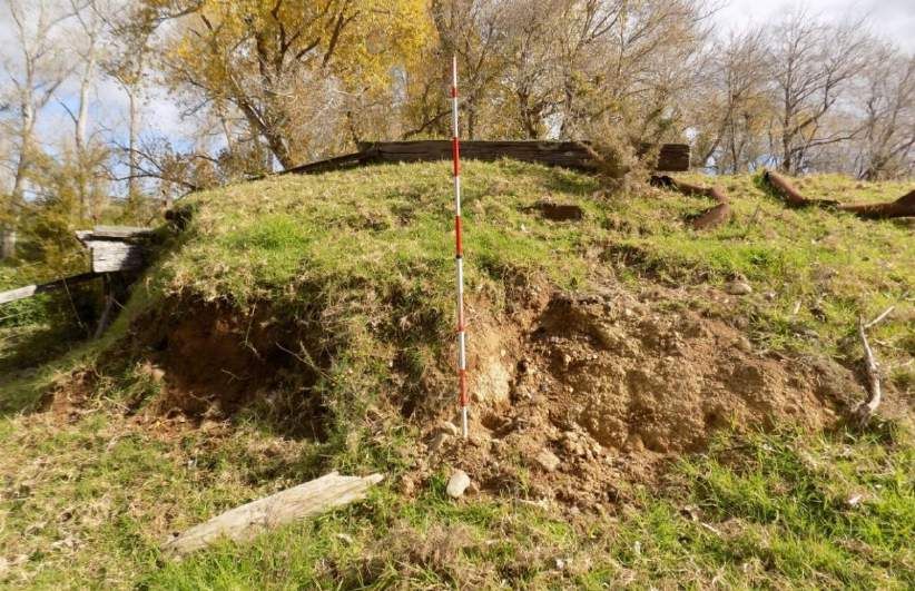
Contents
1.0      Introduction ......................................................................................................... 4
2.0      The Development ................................................................................................. 6
3.0      Methodology......................................................................................................... 8
4.0      Statutory Framework ......................................................................................... 10
  4.1       The Heritage New Zealand Pouhere Taonga Act 2014 .................................. 10
  4.2       The Resource Management Act 1991 .............................................................. 11
5.0      Background & landscape .................................................................................... 13
  5.1        Location ......................................................................................................... 13
  5.2       Landscape ....................................................................................................... 14
  5.3       Soils & Geology ............................................................................................... 15
  5.4       Vegetation history ........................................................................................... 15
6.0      History and Previous Archaeological Work....................................................... 16
  6.1       Maori Settlement ............................................................................................ 16
  6.2
  6. 3
  64
                                                        t
            European Settlement & Development ............................................................ 17
                           f
            The Kaihu Valley Railway ............................................................................... 21
            Previous Archaeological Work ....................................................................... 33
                        ra
7.0      Results ................................................................................................................ 36
  7.1       Railway Formation. ........................................................................................ 36
  7.2       Bridges ............................................................................................................ 41
  7.3       Railway Stations ............................................................................................. 46
      D

  7.4       Wharves .......................................................................................................... 50
  7.5       Booms ............................................................................................................. 52
  7.6       Stockyards ....................................................................................................... 53
  7.7       Water towers ................................................................................................... 54
  7.8       Culverts ........................................................................................................... 54
  7.9       Quarries .......................................................................................................... 56
  7.10 Mills and other industries .............................................................................. 57
  7.11       Other buildings .............................................................................................. 57
  7.12 Other sites ....................................................................................................... 58
8.0      Discussion ......................................................................................................... 59
  8.1       Overview of results ......................................................................................... 59
  8.2       Archaeological Significance and Value........................................................... 61
  8.3       HNZPT Authority Requirements ................................................................... 65

                                                                                        Archaeology North Ltd. Page 2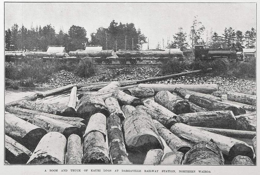
9.0     Assessment Of Effects ........................................................................................68
  9.1     Limitations & Constraints ..............................................................................68
  9.2      Assessment of effects ..................................................................................... 70
10.0      Conclusions ..................................................................................................... 73
11.0      Recommendations .......................................................................................... 74
12.0      References ....................................................................................................... 75

                                                Appendices
Appendix 1: Legal Descriptions and Record of Title

Appendix 2: Plans of Proposed Route

Appendix 3: The Proposal - Extracted from Resource Consent Application& AEE

Appendix 4: Typical Sections
                         f                           t
Appendix 5: Farm Race / Cycle Trail Intersection & Cattle Stop Construction
                      ra
Appendix 6: Draft Farm Races Sections 1 A & 1B

Appendix 7: From the Wairoa to Maunganui Bluff New Zealand Herald 27
September 1887, page 6

Appendix 8: New Zealand Archaeological Association Site Record Form P07/92
      D

Appendix 9: Draft Field Records Showing Locations of Features & Sites P07/92
Kaihu Valley Railway

                                                                                    Archaeology North Ltd. Page 3
1.0    Introduction

The Kaipara District Council (KDC) is preparing to develop the Kaihu Valley Trail
(KVT) a proposed 42 km recreational walking and cycling track running north from
Dargaville up the Kaihu River valley to Donnellys Crossing. The KVT will follow
along sections of the former rail corridor of the historic Kaihu Valley Railway (KVR)
(Fig. 1). The KVT is planned to eventually form part of the Ancient Kauri Trail Byway
that will be developed in stages and eventually link the Hokianga Harbour to the
Mangawhai Coast (KDC 2017).

The KVT project is a joint initiative between KDC, the Northland Transportation
Alliance Waka Kotahi, Te Roroa Iwi, the Northland Chief Executive’s Forum and
Northland Inc. The Department of Conservation (DoC), as owner of part of the
former railway corridor land, is also a key stakeholder and member of the Project
Advisory Board.
                     f                t
The KDC commissioned an archaeological assessment to assess the potential effects
                  ra
of the proposed trail project (the Development) on archaeological and historical
values along the route. This report is intended to identify requirements under the
Heritage New Zealand Pouhere Taonga Act 2014 (HNZPT Act). Archaeological and
historic sites pertaining to the railway were located and described for the report.
   D

Statutory requirements are identified and recommendations are made relating to
mitigation where it is considered that there may be potential effects on
archaeological values.

The trail will be located on a combination of KDC and DoC reserve land (disused
former railway corridor), road reserve, and privately owned land. It is planned to
cross State Highway 12 (SH12) twice.

A list of titles of land the proposed trail involves is included as Appendix One. Most
of the proposed route is owned/managed by KDC or DoC.

                                                           Archaeology North Ltd. Page 4
f                    t
                 ra
 D

Figure 1: Location of the Kaihu Valley Trail running north from Dargaville, Kaipara District. See
              Appendix 2 for additional and larger images showing the KVT route.

                                                                  Archaeology North Ltd. Page 5
2.0 The Development

KDC is seeking resource consent to construct a new walking and cycling trail from
Dargaville to Donnellys Crossing that follows the historic railway formation
originally constructed for the Kaihu Valley Railway Company in the late 19th century
(Figure 1). Appendix 2 contains maps with more detail of the proposed KVT route.
The route was determined from consultations with landowners, engineering
requirements, impact on the environment, and costs.

A description of the proposal extracted from the Assessment of Environmental
Effects (AEE)(Kane 2021) is included in this report as Appendix 3. Details for this
section of the assessment have been drawn from the AEE which recognises that the
trail will go along the old railway formation and that archaeological and heritage
values will be affected (Kane 2021: 29). Compliance with Authority and consent
conditions are expected to adequately manage adverse effects on heritage values.
                       f                     t
The KVT is approximately 42 km long1. Approximately 22 km of the proposed trail
                    ra
route will be off-road. The formed width of the off-road trail will be approximately
3 m within a trail corridor planned to average about 4 m wide. The corridor will be
fenced generally with standard farm fencing. Typical cross sections of the trail are
included as Appendix 4.
    D

Planned earthworks on the KVT will be substantial and will occur over an estimated
maximum area of approximately 66,000m2. The maximum approximate volume of
cutting (primarily removal of topsoil) will be 19,800m3 and the maximum volume of
fill will be approximately 33,000m3. Fill will be an aggregate that will be compacted
to form the new trail surface. It is expected that the actual volumes of cutting (and
potentially fill) will be much lower than these maximum estimates due to the ground
conditions that exist along the railway embankment. Much of the embankment is
largely flat and reasonably well compacted and may require less cutting and filling.

1The AEE state that the KVT will be approximately 42 km long. Other historic sources give slightly
lesser distances for the length of the KVR, but the 42 km is accepted as the distance in this report.

                                                                      Archaeology North Ltd. Page 6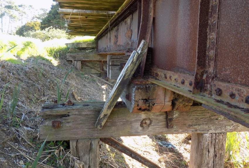
The off-road sections of the trail will provide five bridge structures including over the
Kaihu River; a small tributary just north of Babylon Coast Road, the
Waitakahuruhuru Stream (near Maitahi), the Kaihu River (near Ahikiwi), and the
Waingarara Stream (near to Baker Road). These structures are anticipated to be
designed as single span bridges with any piles and/or abutments located outside of
the watercourses and to not require works within the beds or banks of the
watercourses they cross. Discrete and limited earthworks will likely be required to
construct the bridges. The design for the bridges has yet to be confirmed, but it is not
anticipated that earthworks will exceed approximately 50 m3 for all the bridges
combined. The bridges will be constructed in two stages with Stage 1 including the
Kaihu River Bridge, Ahikiwi Bridge and Baker Road Bridge and Stage 2 the Babylon
and Maitahi bridges and also the Aranga Station Road bridge.

Culverts and/or minor structures will also installed (or extended where existing

                        f                   t
structures occur) to cross open drains or watercourses at several locations along the
proposed route. The culverts will be designed to meet the relevant permitted activity
criteria in the Proposed Regional Plan for Northland2. Further details of the
                     ra
management of the bridge and culvert construction are included in the AEE.

Approximately 20 km of the trail will follow along existing local rural roads that have
low volumes of traffic. These include Station Road, Mamaranui Road, Ahikiwi Road,
      D

Kaihu Wood Road, Opouteke Road, Trounson Park Road and Aranga Station Road.
Parts of Mamaranui, Ahikiwi, Kaihu Woods and Aranga Station Road follow the old
railway route. No earthworks are proposed where the KVT will be located on low
volume roads. These sections of the track will not require an archaeological Authority
application. Small sections of Opouteke and Donnellys Station Roads will also be
utilised. Any earthworks necessary for crossing on SH12 are proposed to be limited.

Consultation with some landowners over the proposed route is on-going. Land can
be included in an archaeological Authority application without owner’s permission,
but such permission must be obtained before an HNZPT Authority can be activated.

2   https://www.nrc.govt.nz/your-council/about-us/council-projects/new-regional-plan/

                                                                   Archaeology North Ltd. Page 7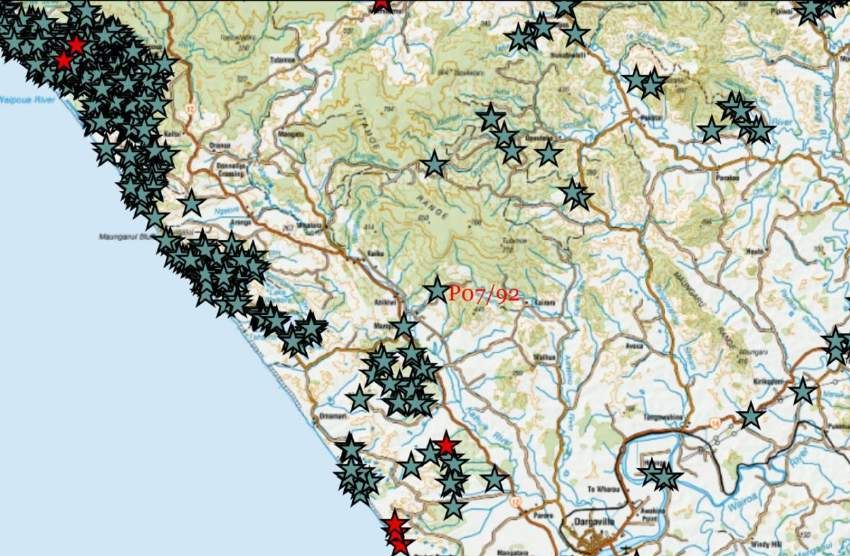
The KDC Northland Economic Action Plan includes the “Byways” concept developed
to help revitalise Northland’s Twin Coast Discovery Highway. Themed Byway routes
have been designed to create tourist journeys around areas of Northland. The KVT
will become part of the ‘Ancient Kauri Trail’ Byway developed for the area in the west
of Kaipara District planned to encourage tourists to stop and explore points of
interest. The Ancient Kauri Trail begins at Maungaturoto, extends through to
Dargaville, and then heads north through the Waipoua Forest to the Hokianga
Harbour. The Byway will highlight the towns and significant features of the area,
including the Matakohe Kauri Museum and Tane Mahuta. The proposed KVT
walking and cycling route is a part of this strategy.

The KVT will provide new opportunities for tourists and local businesses with
additional visitors attracted to the Kaihu River valley and the Kaipara District.
Funding for the project is from the Infrastructure Reference Group (Provincial

                    f                  t
Growth Fund) provided to KDC to progress the design and construct the trail. KDC
has promoted the concept of the trail for some years (KDC 2017).
                 ra
3.0 Methodology

Archaeology North Ltd undertook an assessment to identify potential archaeological
sites during the April-June 2021. The assessment is based on background research
   D

and a preliminary field survey. The field survey was carried out generally in fine
weather. Access to the route was gained through public roads and existing farm
tracks.
Photographs of the remains of the KVR and related facilities were taken and their
locations recorded with a Garmin 60cx GPS. Most of the survey involved walking
along the old railway formation, the focus of the survey.

The assessment included a review of published and unpublished literature covering
the history of the Kaihu valley and surrounding area and railway histories for
relevant information. Significant resource on the history of the railway was provided
by the books J. H. Hansen and F.W. Neil 1992 Tracks in the North and Stephen

                                                            Archaeology North Ltd. Page 8
Fordyce 1998 Longwater. Historical Aspects of the Northern Wairoa and the Kaihu
River Valley History website3.
Heritage and archaeological databases and other sources were also searched for
recorded sites and consulted for this report included:
The New Zealand Archaeological Association (NZAA) on-line site database,
ArchSite4, was searched for recorded archaeological sites in the project’s
vicinity.
The Northland Regional Council and KDC District Plan schedules were
checked for scheduled sites.
The Heritage New Zealand Pouhere Taonga (Heritage NZ) List/Rarangi
Korero.
The HNZPT Digital Library5 was searched for relevant reports from past
archaeological surveys and investigations in the Kaihu valley and wider
f t
Donnellys Crossing to Dargaville area.
Papers Past6, the National Library website, with on-line editions of 19th and
ra
20th century newspapers, was searched for historic reports on the Kaihu
Valley Railway. This site was of particular value.
Early survey plans and surveyor’s notebooks of the area held at Land
Information New Zealand (LINZ) and Archives New Zealand and other
D
sources for information relating to archaeological or historic sites.
A large collection of scans of historic plans of the KVR from the original
surveys of the railway available on-line were included in the assessment
downloaded from Archives New Zealand (but these cannot be reproduced
without permission as the scans are copyright).
Assistance was also provided by Liz Clark and Mark Schreurs who shared their
knowledge and provided information from their records on the railway.
In addition, Archaeology North have over 30 years of experience in surveying
and recording archaeological sites in the Dargaville to Waipoua area. This has
been drawn upon and informed our assessment of the KVT.
3 https://kaihuvalleyhistory.com/
4 http://www.archsite.org.nz/
5 https://www.heritage.org.nz/protecting-heritage/archaeology/digital-library
6 https://paperspast.natlib.govt.nz/newspapers
Archaeology North Ltd. Page 9
Further research beyond the scope of this assessment would be warranted
using collections of information and plans of the KVR held at the Auckland
Public Library (closed at present), Archives New Zealand and at other
repositories.
Ten days were spent walking along the proposed route for the KVT in April-June
2021 by Archaeology North archaeologist, Tore Kronqvist (M.A. Hons), from Waihue
(near to Dargaville) with Laurie Joseph and Dawn Birch, from Te Roroa in Waipoua
Forest, who are trained and regularly work as archaeological assistants. The
archaeological inspections involved a traverse of most of the proposed KVT route,
with detailed ground inspections of selected localities. Written notes, GPS locations,
and photographs were taken at points of interest as the survey progressed and the
results are summarised in this report. Some sections of the route were not surveyed
as access was always not possible (Section 9.1). Modern images in the report were
t
taken during the assessment by Dawn Birch, Tore Kronqvist or Suzanne Reinholds.
f
ra
4.0 Statutory Framework
There are two main pieces of legislation in New Zealand that control work affecting
archaeological sites. These are the Heritage New Zealand Pouhere Taonga Act 2014
(HNZPT Act 2014) and the Resource Management Act 1991 (RMA). Heritage New
D
Zealand Pouhere Taonga administers the HNZPT Act. HNZPT have provided a
template that outlines the legislative framework for archaeological assessments
(2019). This report generally follows that template where appropriate.
4.1 The Heritage New Zealand Pouhere Taonga Act 2014
The 2014 HNZPT Act protects archaeological sites in New Zealand from damage and
destruction. The Act contains a consent (archaeological authority) process for any
work affecting archaeological sites, where an archaeological site is defined as:
“Any place in New Zealand, including any building or structure (or part of a
building or structure), that—
• was associated with human activity that occurred before 1900 or
is the site of the wreck of any vessel where the wreck occurred before
1900; and
Archaeology North Ltd. Page 10• provides or may provide, through investigation by archaeological
methods, evidence relating to the history of New Zealand; and
• includes a site for which a declaration is made under Section
43(1).”
The Act states that no person may modify or destroy, or cause to be modified or
destroyed, the whole or any part of an archaeological site if the person knows, or
ought reasonably to have suspected, that the site is an archaeological site. This
applies whether or not an archaeological site is recorded with NZAA or is entered on
the Landmarks List or the HNZ Heritage List/Rarangi Korero.
Wherever there is a reasonable expectation that an activity may modify or destroy an
archaeological site, an Authority must first be obtained from HNZPT. These
f t
provisions apply to all archaeological sites regardless of whether the site is known
and recorded or whether the site only becomes known about as a result of the activity
regardless of whether the activity is permitted under a district or regional plan or a
ra
resource or building or other consent has been granted.
Unauthorised archaeological site modification or destruction is a criminal offence
and penalties are provided for in the HNZPT Act 2014.
D
4.2 The Resource Management Act 1991
Further protection of heritage resources and archaeological sites is provided by the
Resource Management Act 1991 (RMA 1991). The RMA (S6) requires all persons
exercising functions and powers under the RMA recognise and provide for matters of
national importance when ‘managing the use, development and protection of
natural and physical resources’.
Included in the matters of national importance:
“the relationship of Maori and their culture and traditions with their
ancestral lands, water, sites, waahi tapu and other taonga” (S6(e));
Archaeology North Ltd. Page 11And
“the protection of historic heritage from inappropriate subdivision, use, and
development” (S6(f)).
Historic heritage is defined in S2 of the RMA as:
“those natural and physical places that contribute to an understanding and
appreciation of New Zealand’s history and cultures, deriving from any of
the following qualities: (i) archaeological; (ii) architectural; (iii) cultural;
(iv) historic; (v) scientific; (vii) technological.”
Historic heritage includes:
“(i) historic sites, structures, places and areas; (ii) archaeological sites; (iii)
sites of significance to Maori, including waahi tapu; (iv) surroundings
associated with the natural and physical resources.”
t
These categories are not mutually exclusive, and some archaeological sites may, for
example, also be places that are of significance to Maori.
f
ra
Where a Resource Consent is required for any activity, the assessment of effects is
required to address cultural and historic heritage matters. There is a duty to avoid,
remedy, or mitigate any adverse effects on the environment arising from an activity
(S17), including historic heritage.
D
Regional, district and local plans contain sections that help to identify, protect and
manage archaeological and other heritage sites. The plans are prepared under the
provisions of the RMA. The Northland Regional (NRC) and the Kaipara District
Councils (KDC) are the relevant statutory authorities.
The site of the Aranga Railway Station, part of the KVR, is scheduled in the Kaipara
District Plan as No. H85. The scheduled site will not be affected by the development
as the KVT follows the road near to it. There are no other archaeological or historic
sites scheduled in KDC or NRC plans on or near to the KVT.
Archaeology North Ltd. Page 125.0 Background & landscape
5.1 Location
The KVT will run most of the length of the Kaihu River valley between Dargaville and
Donnellys Crossing7 in Northland (Figs. 1, 2). The environment is predominantly
rural, comprising farmland and some areas of forestry areas. Dargaville is the largest
urban centre in the Northern Wairoa area. The trail will pass through a number of
small settlements including Ahikiwi, Mamaranui, Maropiu, Kaihu, Whatoro, Aranga
and Donnellys Crossing.
f t
ra
D
Figure 2: Extract from a 1925 Lands and Survey Department entitled Auckland (Sheet
No. 2) that shows the railway line running up the Kaihu River valley. It shows several of
the railway stations.
7The name is Donnellys Crossing with no apostrophe (although this is grammatically incorrect). The
name is not official as it does not have an official name (New Zealand Gazetteer, LINZ. Retrieved 12
May 2021).
Archaeology North Ltd. Page 13State Highway 12 forms the main modern roadway running from Dargaville north up
the Kaihu valley through Waipoua Forest to the Hokianga Harbour. It runs roughly
parallel to, and at times besides, the old railway line.
5.2 Landscape
The Kaihu River itself is the dominant natural feature of the relatively level valley
landscape on the southern half of the trail (Fig. 3). The predominant land use in the
river valley is dairying and other grassland farming. Forestry and farming dominate
the foothills on either side of the valley with some areas of scrub and native forest.
The Kaihu River meets the Northern Wairoa River at Dargaville. Several main
tributaries of the Kaihu River were crossed the by the KVT including the Waima
River, Waingarara Stream, Maungatu River, Waiparataniwha Stream, Te Kawau (Te
Kawa) Stream, Te Kapomohi Creek, Taita Stream and Rotu Stream.
f t
To the west of the southern part of the of the Kaihu River valley are a band of rolling
consolidated sandstone ridges cut by several deep swampy gullies that separate the
ra
valley from Ripiro Beach and the Tasman Sea. The Kai Iwi lakes are a notable feature
amongst the western hills.
The northern half of the KVT valley crosses through steeper, more rugged hill
D
country as it rises into the ancient volcanic foothills of Maunganui Bluff and Waipoua
(to the west) and the Tutamoe Ranges (to the east). The Kaihu River and its
tributary, the Waima River, are deeply cut. The landscape is less open and more
remote with an increasing amount of both exotic forest and native vegetation, much
of it conservation land. Trounson Kauri Park, a 586 ha mainland island conservation
reserve administered by DoC, is located south-east of Donnellys Crossing.
Archaeology North Ltd. Page 14Figure 3: Image showing a timber train on the railway line travelling south to Dargaville
crossing level ground (Auckland Weekly News, 9 August 1901 p.5, Auckland Libraries
Heritage Collections AWNS-19010809-5-2).
5.3 Soils & Geology
f t
From Dargaville to Kaihu the proposed trail follows the alluvial Kaihu River valley
where the flood plain there are deep deposits of mud, sand and gravels (Sutherland
et.al. 1980). Beyond Kaihu the land rises and basalt is the predominant rock type.
ra
Soil types along the Kaihu River valley and in the Donnellys Crossing valley are
predominantly Mangakahia silt loam, clay loam and mottled clay loams that provide
fertile agricultural soils. In the past much of the Kaihu River valley was wet land but
has now been drained for farming. Some areas are subject to flooding.
D
5.4 Vegetation history
Much of the Kaihu River valley was wetland with forest dominated by kahikatea
throughout the valley. Kauri forest was abundant on the drier land on the river edges
and on either side of the valley and became more common further up the valley.
Swamp kauri recovered from the lower valley has contributed to scientific research
using tree-ring dating and radiocarbon dating (Lorrey & Boswijk 2017).
The wetlands in the lower river valley were dominated by flax which led to the
foundation of the flax industry at Flax Mill (modern day Parore) where The Kaihu
Flax Company founded constructed a flax processing plant in 1871.
Archaeology North Ltd. Page 15The wetlands and wetland forests in the valley would have been used by Maori for
seasonal hunting and resource gathering, as were the kauri forests and other forest
types on the surrounding hills.
A newspaper described the settlement in the upper Kaihu river on the cusp of the
railways construction.
Maropiu store and native settlement la met with at twelve miles, making the
division between Mr. Tinne's land and the native owned block of Opanake,
also marking the transition from the tree bush to the heavy bush. To this
point the line will be open and trains running by March next. The native
clearings and cultivations here occupy both banks of the Kaihu River at
intervals. The banks show a good depth of brown, friable loam, resting upon
a stratum of boulders and large waterworn shingle. This soil bears an
excellent name for fertility; the natural growth upon it is pretty heavy,
consisting of large puriri, taraire, kahikatea, and nikau, with large kauri on
6). f t
the spurs and ranges at the back (New Zealand Herald, 27 September 1887 p.
ra
6.0 History and Previous Archaeological Work
6.1 Maori Settlement
The history of the Kaihu River valley and its Maori occupation from early times has
D
been outlined in the Te Roroa Waitangi Tribunal Report (Waitangi Tribunal 1992)
and by Garry Hooker (2000).
Hooker’s comprehensive report provides a Te Roroa perspective on Kaipara Maori
traditional history and tribal relationships, as well as the relationships between
Maori and the Crown, and amongst Maori themselves in the Northern Wairoa area.
A focus of the known history was the conflict between Te Roroa and Nga Puhi from
the later 18th and early 19th centuries, which began a cycle of retribution that
continued until the 1830s. Much of the fighting took place in the Kaihu-Opanake-
Omamari-Ripiro area. The conflict between Te Roroa and Nga Puhi and Ngati
Whatua are relatively well described (e.g. Hooker 2000; Smith 1910: 40-56; Waitangi
Tribunal 1992: 10-16).
Archaeology North Ltd. Page 16Human settlement north of Dargaville has long been focused in and along the Kaihu
River (and other nearby) valleys with fortified pa concentrated along the foothills
and villages located near to the rivers and on the valley edges. Settlement was also
clustered along the coast wherever land access to the beach was/is available. Other
nearby Maori occupation in the KVR area was focused around Taharoa (Kai Iwi
Lakes) and Maunganui Bluff, as well as along some of the secondary stream valleys
and wetlands.
From the 1870s the rights to the Kaihu valley and surrounding land and its resources
including the timber, flax and kauri gum were leased by Maori to businessmen
trading in flax, timber and gum. Initially the land remained in Maori ownership but
gradually sections of the land, including that for the railway, and some large portions
were sold or otherwise alienated. The railway traversed the Kaihu and Opanake8
Maori land blocks.
6.2 European Settlement & Development
f t
The earliest written description of the Kaihu River valley was provided by English
ra
trader Joel Polack9 who visited Waipoua about 1832. He lived in the Hokianga and
Bay of Islands between 1831-1837. In the early 1830s he travelled south from
Waipoua with Koruhana and her retinue. She was a niece to Parore, a leader from the
area. Following a route through a “jungle” of dense flax they soon arrived at the edge
D
of a great forest:
...whose densely covered soil produced the various trees common to those
parts. Some were of the largest magnitude, their branches covered with
umbrageous foliage, the soil being impervious to the sun's ray; but little
herbage grew on the land, which was rank from the continual moisture of
decayed vegetation (Polack 1838: 140).
Polack described the hillsides as covered with useful timber but following the route
was hard going with the undergrowth and high straddling tree roots rendering the
paths almost impossible to pass. He described emerging onto a large fern covered
8 The name Opanake was also spelt Opanaki. Te Roroa historian Garry Hooker considered that
Opanake appeared to be the correct spelling (Reed 2002: 232).
9 https://teara.govt.nz/en/biographies/1p18/polack-joel-samuel
Archaeology North Ltd. Page 17plain where the hills on each side were distant and irregular, but apparently well
covered with useful timber. Then he traversed another swamp that was filled with
flax until they reached another plain also covered in flax before arriving at the village
of “Tetaita” (presumably Taita), a village of Parore’s, where there were three large
flax-houses, filled with scraped flax of various qualities. Polack wrote that the flax-
houses were nearly eighty feet (27 m) in length, and thirty feet (9 m) in breadth, with
the lower parts open (rather than walled in).
Resuming their travel they saw masses of kauri gum buried in the earth. Patches of
low forestland were observable in various parts of these plains with swamps that he
described as abounding in flax. Here the hills were sandstone and the marshes filled
with a wiry grass called “hiwi”. Arriving at “Otapanihu”, three houses were erected
quickly for the night. Polack wrote that the place had been formerly a nourishing
village and was where the navigable part of the Kaihu River commenced but now, the
f t
area was deserted and the former tribes that existed there had been entirely
destroyed. From there after a short distance, they soon arrived at the place where
canoes lay anchored amid a quantity of reeds alongside the banks of the Kaihu and
ra
once aboard and seated the three canoes started in company, and were steered down
the river with great rapidity. The river took a devious course and was very narrow.
The canoes were much impeded in their progress by the branches and stumps of
trees in the water, and that blocked the course of the river, but after a time they
D
cleared the obstructions and the stream expanded to some width. The riverbanks on
either side had only tall overhanging flax bushes, and the place was deserted, with
not an inhabitant to be seen. Places that had been particularly populous villages were
pointed out to him. Polack described how these deserted spots that had been villages
left a undefinably unpleasant sensation. After paddling for about five hours past
riverbanks covered with dense flax bushes they landed at a deserted village called
“Nagnereri” and after preparing a meal they set out again. He wrote that they left the
long Northern Wairoa River to their right and travelled to the Mangakahia River
(Polack 1838: 146-150).
Another early European visitor to the Kaihu River valley in 1842 was the missionary
Reverend William Wade who travelled from the Hokianga southwards following the
beach as far as Maunganui Bluff and then proceeded to go inland towards the great
Archaeology North Ltd. Page 18kauri forest and the Kaihu River. Wade was greatly impressed by the kauri forest
when he reached it. He described how it grew “en masse” that was different from
further north, where it only grew here and there as part of a more mixed forest. He
described the forest as growing in "...grand masses, claiming sole possession of
large portions of country, and enriching the landscape with its lovely green." He
then described entering the Kaihu River valley, but provides little detail, writing how
in the course of their journey they had to cross the Kaihu River six or seven times,
sometimes wading knee deep (Wade 1842: 57).
They reached Kaihu village (modern Dargaville) in the evening and were directed
Parore to Paora's (Paul's) wheat field nearby. Wade was both surprised and greatly
impressed with the state of this wheat field that had just been harvested that day and
was been being processed. He described as the land immediately around Kaihu as
level and exceedingly rich and well for cultivation, noting the presence of flax and
f t
raupo that thrived in the swampy lands (Wade 1842: 60-64)
An early European resident in the North Kaipara was the Reverend James Buller who
ra
was a Methodist minister. He lived at Tangiteroria (about half-way between
Dargaville and Whangarei) on the banks of the Northern Wairoa River between the
years 1838 and 1854 with his family. Te Tirarau was the local Maori leader there.
Buller recorded his periodic visits to Kaihu, the settlement at the mouth of the Kaihu
D
River:
Kaihu was the name of a rich valley, just fifteen miles inland, from a point
which was thirty miles or more down the river. A tribe of two hundred, or
thereabout, lived there under the chief Parore. They had embraced
Christianity, and built a church. I visited them periodically. It was then a
rough journey, and in winter, when the woods were inundated, I had, in
places, to walk breast-high in water. They built me a little cottage, as I
always stayed several days with them. It was supplied with the prophet's
furniture – "a bed, and a table, and a stool, and a candlestick." A few apple
trees were planted within the fence that enclosed it. The wife of my old
teacher, Hohepa Tapapa, had charge of it. When I was expected, she would
put it in order: a clean layer of fern was provided, boiling water was poured
over the ground-floor – this was to destroy the fleas, – and a new mat was
laid down (Buller 1878: 65).
Archaeology North Ltd. Page 19Apart from isolated travellers the Northern Wairoa and particularly the Kaihu valley
remained relatively isolated from European settlement and influence until after 1870
when Maori first leased (and then later sold) the land. The leases provided out-siders
with access to the flax, timber, and kauri gum. By 1870 there thriving towns in other
parts of the Kaipara Harbour, including at nearby Aratapu and Te Kopuru, where
timber milling and ship building were flourishing industries.
In 1871 the Kaihu Flax Company Limited, acquired a lease to harvest flax from the
large Te Roroa owned Kaihu No. 1 block and constructed a flax mill at Flax Mill
(modern Parore) in the lower Kaihu River valley (Coates 1975: 10-13; Reed 1956;
Tinne 1873). After the mill was destroyed by fire in 1872 the owners started The New
Zealand Fibre Company and rebuilt the mill with new machinery (Coates 1975: 128;
Daily Southern Cross, 16 November 1872 p.2; 18 November 1872 p.3). The company
manufactured flax products, including paper, rope, twine, door mats, and roofing felt
f t
(Coates 1975: 33; Reed 1956: 346-7; Tinne 1873).
In 1871 an Auckland based businessman, Mr Joseph M. Dargaville, visited the
ra
Northern Wairoa and recognising the business potential in the area leased 1.6 ha (4
acres) near to the Kaihu River mouth from local Maori leader Parore Te Awha10. The
locality was then known as Kaihu11. Here Dargaville opened a store and developed his
business trading in timber and kauri gum with Edwin Mitchelson12 as his local
D
manager. In 1872 Dargaville purchased the Tunatahi land block of 69 hectares (171
acres) from Parore and others and proceeded to build a private town (later named
Dargaville) at the junction of the Kaihu and Wairoa Rivers. In 1876 Dargaville sold
part of his timber interests to the Union Sash and Door Company. Edwin Mitchelson
took over Dargaville’s other businesses, founding E. Mitchelson and Company with
brothers Richard and John and developed a large trade in timber and kauri gum.
10https://teara.govt.nz/en/biographies/2p8/parore-te-awha
The location and settlement at the confluence of the Kaihu and Wairoa Rivers was originally named
11
Kaihu, but the new town became named Dargaville. The name Kaihu became used as the name for the
small settlement previously called Opanake, north of Dargaville
12
Archaeology North Ltd. Page 20By 1878 the town become known as Dargaville and had grown from “… a kauri gum
store, and one or two Maori whares…” to have become a substantial enterprise with
numerous houses and cottages, its own public hall able to hold 250 people, a first-
class hotel with another under construction, a bank branch, a library, a Masonic Hall,
several substantial detached stores and tradesmen’s shops, the large riverside E.
Mitchelson and Co. store, a courthouse with a lock-up, a billiard room, a bowling
alley and “..one of the best churches north of Auckland” (New Zealand Herald, 1st
July 1878 p.3; Reed 2002: 112; Ryburn 1999: 58).
6. 3 The Kaihu Valley Railway
In 1882 Dargaville13 and Mitchelson14 (by then both Members of Parliament), and
seven other businessmen formed the Kaihu Valley Railway Company. The company
contracted to build a railway line about 31. 4 km (19.5 miles) up the Kaihu valley to
be linked with the port on the Wairoa River at Dargaville within 5 years15.
Construction of the railway was made possible by the Railways and Land Act 1881
f t
which enabled settlers to build and manage railways in New Zealand. As an incentive
the Company was to receive 5,872.5 ha (14,501 acres) in land and timber grants.
ra
The first sod on the KVR was turned by Mr Dargaville on 20 March 1883 on a fine
day in presence of crowd of 700 residents and settlers from the surrounding districts.
A triumphal arch was erected in Portland Street, Dargaville, and the Hobson
D
Garrison Band played. The ceremony commenced with Mr Dargaville addressing the
assembled crowd. He stated that the object of the railway was to open the bush
country in the Kaihu valley, noting that about twenty miles away was a forest of kauri
said to be the finest in the northern portion of the Auckland Province. Dargaville
declared that the new railway would make over 100,000 acres of “…some of the finest
land in the colony…” available for profitable settlement, provide employment for
hundreds of workers and utilise immense tracts of kauri forest, with an estimated
300,009,000 feet of kauri within reach of the railway. Future extensions of the rail
13 Joseph Dargaville was a Member of Parliament from 1881-1887 (Mogford 1993a).
14 Edwin Mitchelson was a Member of Parliament from 1881 to 1896, and held a number of cabinet
positions between 1887-1891 and served as Acting Premier, and Colonial Treasurer, for 12 months
during 1890 when Prime Minister Atkinson was ill (Mogford 1993b).
15 Kaihu Valley Railway. Contract Entered into between Her Majesty The Queen and The Kaihu Valley
Railway Company (Limited) (Appendix to the Journals Of The House Of Representatives, 1882
Session I, D-11).
Archaeology North Ltd. Page 21would reach much more kauri. The men employed in the bushes and on the mill
works would be consumers of large quantities of beef, mutton, pork, butter, and
other farm product, so that settlers would have an excellent market on the spot. After
the ceremony two hundred guests sat down for luncheon in the Raynes’ Hotel
(Auckland Star 20 March 1883, p. 2; New Zealand Herald, 21 March 1883, p. 6).
In 1887 with the anticipated the arrival of the steel track and 15,000 sleepers on
hand the newspaper extract detailed the work necessary for the construction:
The railway, as a railway, should work very well, for the general course of
the line is straight, there are no great heights to be overcome, and the curves
are neither numerous nor cruel. The governing is one in 581⁄2, and of this
there are only a length of twelve chains; there is one over of eight chains
radius, one of nine, the majority are of fifteen to forty chains radius, and
there are no reverse curves. Where the curves exist the line is level or of very
f t
slight inclination, while there are many stretches of level upon which an
engine-driver can make time. The formation level is kept eighteen inches
above ascertained flood level. Packs of drift timber in the Kaihu River have
ra
dammed up flood waters to an unusual height at times, but it will become
the duty of the line tenders to remove these, and with them their attendant
dangers. Mr. Morton Williams, chief engineer of the line, is confident that all
danger from floods is removed by his arrangements: for fourteen or fifteen
D
chains embankments hare been raised to guard against the effects of the
packs in the river, but of embankments raised to the full height determined
on, no one has been submerged. The bridges are stoutly made, considering
the weight they are to bear. Where washing of the embankments by flood
water is looked for, fascine work will be resorted to in the first instance, and
when the rocky gorge is entered, the stone obtained in excavation will be
used in making aprons of loose rubble (pierres perdues), or " rip-rap," as
our American cousins call it, in replacement of the fascines. Where the banks
are Bandy the rubble work will need a further backing of small shingle to
prevent the washing through of the sand. Barrow-pits have been largely
resorted to to find the stuff for the embankments, as the cuttings actually
needed are both shallow and short. The line will be laid with flat-footed,
single-head rails of Bessemer steel, 53lbs to the yard, fastened down with
fang spikes. The rail joints will be simultaneous, made upon the sleeper,
flanged fishplates being used. The gauge is 3ft 6in. The vessel with the first
instalment of the iron is due at Dargaville the middle of this month
Archaeology North Ltd. Page 22(September), and the laying of the rails will commence on her arrival.
Fifteen thousand sleepers are already on the ground. The line will be
ballasted with river shingle, taken from an old bed of the Kaihu, and with
the advent of the four-wheeled "pony" engines, ballast trains will be run.
The standard type of engine will be a sis-coupled, twenty-ton engine of short
wheel base, and the remainder of the rolling stock will be of the kind usual
on our railways. The cost of the whole line, equipment included, will be kept
much within the primary estimate, and by this time next year, if not before,
the line will be regularly open for traffic throughout. (New Zealand Herald,
27 September 1887 p.6; Appendix 7).
The first section of the railway ran across comparatively level river flats and required
the construction of an earth embankment to raise the rail track above the wetlands.
These embankments are perhaps the most conspicuous remains of the railway visible
today. By 1888 26.6 km (16.5 miles) of track had been laid from Dargaville to a point
south of Opanake16 and just to the north of Maropiu.
f t
However, difficulties with finances, and disputes over business arrangements and
ra
land ownership led to delays in the work and the company were mortgaged to the
Government (Hansen & Neil 1992: 55; Ryburn 1999: 84-85). With finance available
railway contractor Daniel Fallon commenced working in October 1888 to extend the
unopened line a further 4.02 km (2.5 miles) to Opanake (modern Kaihu). He
D
employed about 40 men to construct the line, which included forming and laying the
track as well as the erection of bridges. Fallon was also readying an additional 1.6 km
(1 mile) of track for metalling and laying that took the railway past Opanake to the
Kaihu Booms and edge of the Opanake forest.
At about the same time Fallon was also preparing to clear another 4.4 km (2.75
miles) of railway track through dense kauri bush further up the Kaihu River valley to
Whatoro where it meets the Waima River (although this section was not completed
for use until 1914) (Fordyce 1998:63, 76).
16 Opanake or Opanaki was the original name of the place now called Kaihu. However, the locality
originally reached by the railway and called the Opanake Station was short of the actual place then
called Opanake (modern Kaihu). The name was changed to Kaihu in 1896 (Reed 2002: 232).
Archaeology North Ltd. Page 23A newspaper described the railway and Fallon’s preparation to advance the line:
This Railway, belonging to the Kaihu Valley Railway Company, is now
completed to the extent of sixteen and a-half miles, reaching a short distance
beyond Maropiu… At Dargaville, a picturesque little station has been
erected, with the usual offices; an engine-house capable of holding the two
engines at present on the line, has been provided, with coaling and water
appliances adjacent. A substantial wharf, with deepwater frontage to the
Northern Wairoa River, has been built, with a timber slip for discharging
logs from the trucks in close proximity. As far as at present constructed, the
line has presented very few engineering difficulties, having comparatively
level country to traverse. It, however, reflects credit on those concerned in
its construction, travelling, even at a high speed, being remarkably smooth
and easy. A further distance of little short of a mile has been prepared ready
for metalling, which brings the line to the kauri bush in the Opanika [sic]
district, and where Mr. Daniel Fallon has commenced operations to carry
f t
the railway another two and three-quarter miles through this dense bush
and broken country. The work at sight seems a stupendous one, but is in
able hands, and, during the brief time at his command, Mr. Daniel Fallon
ra
has shown that he has resources quite equal to the occasion. The survey pegs
mark the line to go through numerous spurs of hills, over valleys
necessitating deep cuttings and heavy embankments, and about five
substantial bridges… Mr. Fallon has first felled the bush on the line of
railway already nearly all the distance. He has sawpits at work cutting the
D
kauri into suitable sizes for culverts and bridges, and also for the
construction of - several of which are now ready and in use. He has, in
addition to the sawpits, a blacksmith's and a carpenter's shop in full swing,
two large stores erected in the heart of the bush, camp erections occupied by
about a hundred people, and stabling for over twenty horses engaged. He
has already opened out about twenty-four faces to half that number of
spurs, and has gangs of men with either waggons [sic.], drays, or
wheelbarrows, in full work at each of these points of attack. The track has
also had to be formed through the bush to get the horses and drays to
distant workings; but, judging from what has already been accomplished, it
will not be the contractor's fault if the progress of the work is at all delayed.
The line in this section goes through the most romantic scenery imaginable;
and, when the railway is opened for passenger traffic, it will be well worthy
of a visit before the beauties of the forest are decimated by the bushman's
axe. There are thousands of magnificent kauri trees in all stages of growth,
Archaeology North Ltd. Page 24and so close in many instances as to exclude the sun's rays beneath their
foliage. One monarch of the forest measures no less than 38 feet in
circumference and gives every indication of being a mottled kauri. Another
giant of scarcely less size rears its stately trunk to a great height, putting all
other trees in the shade (New Zealand Herald, 21 December 1888 p. 6).
The KVR rail service started running to Opanake Station on 16th January 1889 (Daily
Telegraph 17 January 1889 p. 3) (Fig. 4). An earlier service had run on 10 January
1889 when a special train was provided for the Hon. G. F. Richardson, Minister of
Lands, who was travelling from the Hokianga via Kawerua to Dargaville (New
Zealand Herald 9, 10 January 1889 p.6).
f t
ra
D
Figure 4: Extract from a Lands and Survey based map entitled “The Timber Industry of
New Zealand. Number and Position of Mills, 1906-1907”. The map shows the Kaihu
Valley Railway extending from Dargaville to Opanake, but no other stations. It also shows
the locations of Trounson’s sawmill at the Kaihu Booms and another mill near to the
mouth of the Kaihu River at Mangawhare and other mills.
Archaeology North Ltd. Page 25Other visitors also took the opportunity to travel on the new rail line. An “…excursion
of gentlemen” to the “Opanake Bush” one hour from Dargaville on a special KVR
train was advertised for Saturday 2nd February 1889. After arriving at Opanake the
excursion was to continue with a walk of 0.8 km (0.5 mile) to the kauri bush on the
track that was not yet metalled. The paper reported that here, Mr. Fallon was
penetrating a further distance of 4.8 km (3 miles) into the virgin forest. It continued
“The scenery here is weird and romantic to a degree, but now made easily
accessible by means of the iron horse” (New Zealand Herald 26 January 1889 p. 4).
In April 1889 a report stated that the contractor was making good progress on the
last KVR extension using close on 90 picked workmen for the work (New Zealand
Herald and Daily Southern Cross 16 April 1889 p.4). However, the railway company’s
financial difficulties continued and in May 1890 the Government took possession of
the railway. Mr Fallon was advised to cease operations for the present (New Zealand
f
had been largely completed.
t
Herald 1 May 1889 p.5). By this time, the earthworks for the extension to Whatoro
ra
In 1892 the dairy factory was opened in Dargaville, and the new line began to be used
to transport cream from the developing dairy farming industry. The primary purpose
of the original railway line was seen as the extraction of kauri logs from the forests,
but it was also recognised it would then provide support for the conversion of cleared
D
land into farms.
Fallon was not paid for his work and a deputation of businessmen lobbied Prime
Minister Seddon to pay Fallon £8000 "for work done on the Kaihu Valley railway"
(New Zealand Herald 8 June 1892 p.6).
After the KVR failed to sell at auction the Government acquired the railway (Hansen
& Neil 1992: 55). The line was then operated by the Public Works Department (PWD)
until the beginning of 1893 when it was transferred to the Railways Department
(NZR).
Archaeology North Ltd. Page 26f t
ra
D
Figure 5: A KVR timetable from 1893. It names the stations on the line, the distances
from Dargaville and Donnellys Crossing and the time the train stops on different days. All
of the stations except Dargaville are shown as Flag Stations 17 (Wairoa Bell, 7 July 1893,
p.9).
A Flag Station is a railroad station where trains stop only when a flag or other signal is displayed or
17
when passengers are to be discharged. Ma ro p iu , Ro tu a nd Ah i k i wi we re o p en fo r
pa ss en g ers a nd p arc el s o nly .
Archaeology North Ltd. Page 27under the Railways Authorisation and Management Act 1891 and was operated as an
ordinary Government owned railway (Appendices to the Journal of the House of
Representatives (AJHR), 1893, D-1 p. xi).
An NZR timetable (Fig. 5) provided details of the stations that were operating at that
time and their distances from Dargaville. A new station and goods shed at Opanake
were reported as completed in September 1893, replacing a locally owned shed that
had been used until then (New Zealand Herald, 12 September 1893 p.6).
The Kaihu Valley Railway Extension Act 1895 authorised the construction of an
extension of the railway from the Opanake to the Waima (AJHR, 1895, D-1, p. viii).
The extension of the railway the short distance from Opanake Station to (modern)
Kaihu was completed on 11 November 1895 (Hansen & Neil 1992: 56). By December
f t
1896 a new station and post office were nearly completed and a number of business
premises had been built (Auckland Star, 16 December 1896 p. 3).
ra
D
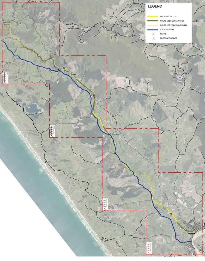
Figure 6: Trounson’s sawmill at the Kaihu Booms in 1912. Note the KVR railway line.
On the right of the image is a dam with logs floating in the water behind. This is where
the boom, a floating barrier, that kept the logs contained (Auckland Weekly News, 1
September 1912 p.11, Auckland Libraries Heritage Collections AWNS-19100901-11-1).
Archaeology North Ltd. Page 28f t
ra
D
Figure 7: Extract from an 1894 Lands and Survey Cadastral map of Hobson County
(Sheet No. 1) stamped as PWD 17574. The map shows the KVR including Dargaville, Flax
Mill, Rotu Maitahi, Dairy Flat, Maropiu and Opanake (Kaihu) Stations. The track is
marked as extending beyond Opanake to Tarawhati marked as the “Terminus Waima” at
19 miles 10 chains. This may indicate the work carried out by Fallon. The marked route of
the railway also appears to have been extended with a lighter shaded line as far as
Donnellys Crossing and then again in a dashed line north to the edge of the map (source
Archives New Zealand).
Archaeology North Ltd. Page 29The next short extension of the line, 1.1 km (55 chains) long, from the Opanake (ie
Kaihu) to the booms on the Kaihu River was completed and handed over to the
Railway Department for traffic on 21 October 1896 (AJHR, 1897, D-1, p. iii) (Fig. 7).
Here James Trounson who owned large tracts of land and timber to the north of
Opanake/Kaihu had constructed a large sawmill beside the Kaihu River. Timber
booms (in the river) and skids also had been constructed ready for the transfer of
logs from the river to the railway (AJHR, 1896, D-1, p. viii) (Fig. 6).
A 1905 newspaper provided an informative description of the railway line from
Dargaville and its importance in the development of the Kaihu River valley and
surrounding area:
Dargaville, in addition to being a shipping centre, has also got a railway,
and that is an important item… That line, however, is the third best paying
t
line in the colony, and Dargaville has a right to be proud of it. Passenger
trains run on Tuesdays, Fridays, and Saturdays, but there is a frequent log
f
service, that is, the carriage of logs from the bush up the line to the river at
ra
Dargaville, where the timber is shot off and floated down to the sawmills.
Leaving Dargaville the train runs up the Kaihu Valley for a few miles, past
rich alluvial flats, still covered with native growth. At the flaxmill (four
miles) the Kaihu Creek is crossed, and there a number of old age pensioners
are gaining a small livelihood at gumdigging. The flaxmill employs some 30
D
men, and this trade is, of course, catered for by the railway. A mile past the
flaxmill is Babylon18, which is not much like the other Babylon, but it is a
gum buying centre. A few miles further up the road leads into a much better
class of country, especially as the train approaches Dairy Flat, and there the
beautiful rich pastures and the well conditioned cattle give ample
demonstration of the value of the soil when cultivated. The fact of the matter
is the soil anywhere on the flats in the Wairoa district is all right when
cultivated and drained, and in many parts it is exceptionally rich. Passing
Rotu, Maitahi, and Taita, one comes to Maropiu, 13 miles from Dargaville,
where the land is all of first-class quality, and there are some very pretty
scenic glimpses along the line at this stage. A good hotel has been
established in the district, and one desirous of spending a pleasant day or
18Babylon was a main trading centre and gum field where the many nationalities of gum diggers lead
to a “confusion of tongues” as amongst those in the Old Testament who erected the Tower of Babel
(Coates 1975: 25; Fordyce 1998: ix, Reed 2002: 32).
Archaeology North Ltd. Page 30You can also read