The risk of global weather connections - Are atmospheric hazards independent? - NATURAL ENVIRONMENT
←
→
Page content transcription
If your browser does not render page correctly, please read the page content below
Emerging Risk Report – November 2016

NATURAL ENVIRONMENT

The risk of global
weather connections

Are atmospheric
hazards independent?

                                       Lloyd’s Emerging Risk Report – 2016
Disclaimer Key Contacts
This report has been produced for Lloyd’s by the Met Trevor Maynard
Office for general information purposes only. While Head, Exposure Management and Reinsurance
care has been taken in gathering the data and preparing trevor.maynard@lloyds.com
the report, Lloyd’s does not make any representations
Lucy Stanbrough
or warranties as to its accuracy or completeness, and
Executive, Emerging Risks and Research
expressly excludes to the maximum extent permitted by
lucy.stanbrough@lloyds.com
law all those that might otherwise be implied.
For general enquiries about this report and Lloyd’s
Lloyd’s accepts no responsibility or liability for any loss
work on emerging risks, please contact
or damage of any nature occasioned to any person as
emergingrisks@lloyds.com
a result of acting or refraining from acting as a result
of, or in reliance on, any model, statement, fact, figure
or expression of opinion or belief (or any part thereof ) About the authors
contained in this report. This report does not constitute Hamish Steptoe is an applied climate scientist with
advice of any kind. the insurance and capital markets team at the Met
© Lloyd’s 2016 All rights reserved Office. He holds an MSc in applied meteorology from
the University of Reading and a second MSc in earth
The Met Office aims to ensure that the content of science from Utrecht University, The Netherlands.
this document is accurate and consistent with its best Since starting at the Met Office in 2014, Hamish has
current scientific understanding. However, the science been involved in developing products for European
which underlies meteorological forecasts and climate windstorms, whilst continuing research into the
projections is constantly evolving. Therefore, any representation of large-scale climate process in global
element of the content of this document which involves climate models at the University of Reading. He has
a forecast or a prediction should be regarded as the Met also been involved in projects for the BBC and the
Office best possible guidance, but should not be relied Royal Meteorological Society and has advised on the
upon as if it were a statement of fact. To the fullest scientific aspects of recent expeditions to Madagascar,
extent permitted by applicable law, the Met Office Mongolia and the Indian Himalayas.
excludes all warranties or representations (express or
implied) in respect of the content of this document. Trevor Maynard PhD, MSc, FIA has degrees in pure
maths and statistics and is a Fellow of the Institute of
Use of the content of this document is entirely at the Actuaries. He is head of exposure management and
reader’s own risk. The Met Office makes no warranty, reinsurance at Lloyd’s and is responsible for monitoring
representation or guarantees that the content of this the natural and manmade aggregations of risk across
document is error-free or fit for your intended use. the Lloyd’s market including emerging risks. Subjects
Before taking action based on the content of this covered in recent years include: the economic and social
document, the reader should evaluate it thoroughly implications of a food system shock; the effects of
in the context of his/her specific requirements and cyber-attacks on the US energy grid and an exploration
intended applications. of aggregation modelling methods for liability risks.
To the fullest extent permitted by applicable law, the He is co-chairman of OASIS, an open modelling
Met Office, its employees, contractors or subcontractors, platform for catastrophe models and sits on the Board
hereby disclaim any and all liability for loss, injury or of the Lighthill Risk Network.
damage (direct, indirect, consequential, incidental or
special) arising out of or in connection with the use Acknowledgements
of the content of this document including without
Lloyd’s would like to thank the following people for
limitation any and all liability:
their contribution in reviewing various aspects of this
• Relating to the accuracy, completeness, reliability, study: Mike Davey from the Centre for Science and
availability, suitability, quality, ownership, non- Policy, University of Cambridge; Theo Economou, Helen
infringement, operation, merchantability and fitness Fox, Emily Wallace, Paul Maisey, Ed Pope, Chris Kent,
for purpose of the content of this document Jennifer Rourke and Steven Wade from the Met Office .
• Relating to its work procuring, compiling,
Lloyd’s is also grateful to Ed Wheatcroft from the
interpreting, editing, reporting and publishing the
Centre for the Analysis of Time Series at the London
content of this document
School of Economics for carrying out a statistical study
• Resulting from reliance upon, operation of, use of or of past extreme events in the region-perils specified. His
actions or decisions made on the basis of, any facts, work augments the driver-based study that occupies the
opinions, ideas, instructions, methods, or procedures majority of this paper.
set out in this document
Lloyd’s ‘The risk of global weather connections’
Nothing in this disclaimer affects the Met Office’s project team:
liability for death or personal injury arising from the Met
Office’s negligence, or the Met Office’s liability for fraud Trevor Maynard, Exposure Management and
or fraudulent misrepresentation, or any other liability Reinsurance
which cannot be excluded or limited under applicable law. Sundeep Chahal, Lloyd’s Catastrophe Model
If any of these provisions or part provisions are for Lucy Stanbrough, Emerging Risks and Research
any reason held to be unenforceable, illegal or invalid,
that unenforceability, illegality or invalidity will not
affect any other provisions or part provisions which will
continue in full force and effect.
Lloyd’s Emerging Risk Report – 2016The risk of global weather connections
Contents
Executive summary 04
1. Introduction 07
2. Methodology 08
2.1 Region-peril definition 10
2.2 Global climate drivers 11
2.2.1 Descriptions of climate drivers 12
2.3 Identifying key climate drivers 16
2.4 Simulating key climate drivers 17
2.5 Simulating region-peril indices 21
3. Model results 24
3.1 Simulating conditional extremes 28
4. Conclusions 31
5. Next steps 36
Appendix A: Source Data & Mathematical Descriptions 37
A1. Source Data 37
A2. Mathematical Descriptions 37
Appendix B: Peril-Driver Seasonality 41
References 43
Materials accompanying this study available online
Appendix C – Regional perils literature
Technical Report – Can perils reasonably be assumed to occur independently in time
Lloyd’s Emerging Risk Report – 2016The risk of global weather connections 04
Executive summary
Background If it is not, regulators could require insurers and
reinsurers to hold more capital to cover their exposure
Major atmospheric-driven catastrophes, such as to potentially greater insurance losses. This requirement
hurricanes and floods, may appear to be independent would tie up funds that could otherwise be allocated to
events when looked at historically. Yet it is well new business development, such as developing products
established in climate science that regional weather for new threats e.g. cyber risks.
and climate conditions in one part of the world can
have impacts on other parts. Changes in temperature or To establish whether the assumption of independence
humidity that result in increased rainfall in one ocean in insurers’ internal models is appropriate, and to
basin might also create conditions favourable for storm increase insurers’ and regulators’ understanding of the
development that affect communities thousands of implications of teleconnections for risk modelling,
kilometres away. Lloyd’s commissioned the Met Office to investigate
the extent of the links between different global
In weather and climate science, links between extreme extreme weather perils and the mechanisms for these
weather events occurring in separate regions of the dependencies.
world, taking place over timescales from days to years,
are known as teleconnections.1 This report answers the question: is it reasonable to
assume independence between significant weather risks
The best known teleconnection, the El Niño Southern in certain region-perils around the world?
Oscillation phenomenon, drives changes in weather
patterns globally by affecting large-scale atmospheric Groundbreaking methodology
circulation across the tropics. These changes modify
rainfall patterns and can cause flooding, droughts Lloyd’s worked with the Met Office to develop
and heatwaves.2 El Niño years typically have more an innovative methodology for assessing the
active Pacific typhoon seasons while La Niña years, interconnectivity of global weather events. The
the opposite phase, represented by colder than normal comprehensive approach detailed in this study is
sea surface temperatures, typically have more active believed to be unique because it analyses the potential
Atlantic hurricane seasons. Given the interconnected links between weather events globally, whereas existing
nature of the “Earth system” – the Earth´s interacting methodologies cover single regions only.
physical, chemical, and biological processes – it is
therefore possible for weather events or perils in And in a groundbreaking move, Lloyd’s and the Met
different regions (known as region-perils) to be Office have disclosed the methodology in full for
connected to the same driver. general review purposes and to encourage debate (see
Appendix A for full details of the methodology). Both
Implications of weather connections for insurers Lloyd’s and the Met Office hope that by adopting this
approach other modellers can add to and improve the
But just how interconnected are these climate drivers? methodology.
The answer to this question is important for insurers,
and particularly reinsurers, both of whom are required To create the methodology, 16 region-perils were chosen
by regulators to hold a level of capital that adequately on the basis of their relevance to the Lloyd’s market. The
reflects their exposure to losses from significant weather Met Office then identified 22 potential “Earth system
events. It is the insurer’s responsibility to demonstrate drivers” (such as El Niño) that could be connected
to the regulator that they hold adequate levels of to these region-perils. The Met Office selected nine
capital. For example, the Corporation of Lloyd’s uses an of these based on characteristics of influence and
internal model to calculate the capital required by the seasonality that related most closely to answering the
market, this model covers many perils, such as hurricane question of independence posed by Lloyd’s.
risk, windstorms, winter storms, hail and flooding, in
multiple regions around the world to show that its The next stage involved analysing the various
capital is adequate. interactions between perils and climate drivers, which
showed the extent of the potential connections between
The Corporation of Lloyd’s internal model is based weather events. The degree of correlation between the
predominantly on the assumption that extreme weather climate drivers and the chosen region-perils was then
events occur independently of each other. Recently, assessed following a comprehensive review of existing
however, some in the regulatory community have research literature from more than 200 sources (see
started to question whether extreme weather events Appendix C). Last, a model was run to produce 16
are more interconnected than previously thought and region-peril indices which captured the background
whether the assumption of independence is appropriate. level of risk for each peril.
Lloyd’s Emerging Risk Report – 2016The risk of global weather connections 05
From this data the Corporation of Lloyd’s was able 3 Even when there are high correlation levels
to assess whether the assumption of independence between weather events, it does not necessarily
between weather events is appropriate. follow that there will be large insurance losses.
For atmospheric hazards to cause major insurance
Additional research losses, a rare major atmospheric event has to take
place in combination with other circumstances
To complement the main approach in this paper Lloyd’s conducive to such losses (e.g. a weather event
also worked with Ed Wheatcroft, an independent affecting a major urban centre). Such circumstances
statistics consultant based at the Centre for Analysis of are so rare that even when atmospheric conditions
Time Series, London School of Economics are conducive to a major weather event, they do not
always occur. Conversely, large losses sometimes
His data-driven statistical study (see Section 3.1, Box 2, occur in years when the correlation levels are not
p30) considered the assumption of independence from as high. For example, Hurricane Andrew (see case
a number of different angles, including whether it is study, p6 and p33), which caused one of the largest
reasonable to assume so between perils of the same type, insurance losses of the 20th century, occurred in an
whether there are links between different types of perils El Niño year – a climatic feature that tends to reduce
and whether there is evidence to reject the assumption the likelihood of hurricane development.
of independence when considering significant weather
events that take place simultaneously. The study looked 4 Weather events can still occur simultaneously even
at whether there was any significance in the number if there is no link between them.
of times each type of peril took place annually using Extreme weather events can still take place at the
available data sources. same time even though this study confirms that
weather events can be modelled as independent.
This conclusion of this second study is consistent with Indeed, the Corporation of Lloyd’s internal model
the findings set out below. generates scenarios that show multiple massive
catastrophes occurring in the same year, despite
The key findings underlying assumptions of independence.
1 For extreme weather events an assumption of Overall conclusion
independence is appropriate.
The results of running the methodology in this report The results of the modelling presented in this study
through the Corporation of Lloyd’s internal model demonstrate that an assumption of region-peril
demonstrate that the assumption of independence independence is currently appropriate for use in
between weather events in models used by the modelling extreme natural catastrophe risks.
insurance industry remains appropriate.
This important finding supports the broader argument
2 A number of regions show some correlation that the global reinsurance industry’s practice of pooling
between climate drivers but these are not risks in multiple regions is capital efficient and that
considered to be substantial enough to warrant a modelling appropriate region perils as independent is
change in our capital. reasonable.
While there is some level of dependency between
perils, the findings of both the data-driven statistical This challenges the increasingly held view among
study (see Section 3.1, Box 2, p30) and the model some regulators around the world that capital for local
presented in the main body of this study are that risks should be held in their own jurisdictions. Lloyd’s
the impact of this on insurance capital modelling is believes this approach reduces the capital efficiency of
negligible. Only nine of the 120 peril correlations the (re)insurance market by ignoring the diversification
analysed in this study showed any significant links, benefits provided by writing different risks in different
and the links can be both positive and negative. locations and, in so doing, needlessly increases costs, to
For example, the study confirmed that while the El the ultimate detriment of policyholders. Insisting on the
Niño-Southern Oscillation influences the majority fragmentation of capital is not in the best interests of
(14 of 16) of regional weather perils, it also reduces policyholders.
the impact of 10 of the 14 perils for three months of
the year.
Lloyd’s Emerging Risk Report – 2016The risk of global weather connections 06
Next steps Note on the methodology
Modellers can use external data creatively and While this report finds that an assumption of
innovatively to complement the insurance market’s independence is appropriate when modelling weather-
specialist data, and both Lloyd’s and the Met Office related insurance losses, it is important to recognise
have disclosed the methodology in full for general the limitations of the methodology presented, which is
review purposes to encourage debate (see Appendix A for based on the current state of climate dynamics and does
full details of the methodology). Lloyd’s welcomes dialogue not account for possible future change in the Earth’s
and development from any and all sectors to add to and climate system. It is also based on assumptions that any
improve the methodology. interaction between weather events is captured by the
methodology’s driver simulations.
Whilst future studies could use numerical weather
predication models to further assess these implications
(see p36 for more details), Lloyd’s believes that additional
modelling efforts would be best directed to further
studies. These could focus on topics such as augmenting
the list of historical events with simulated examples to
ensure that insurers are prepared for the full range of
potential risks.
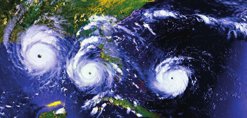
Case study – Hurricane Andrew
This case study highlights the potential for extreme El Niño phase. One measure of hurricane season
events to occur even though climate conditions are strength is known as the Accumulated Cyclone
unfavourable for their development. Energy (ACE) Index. In 1992, the ACE Index was
below normal at 76, compared to 250 in 2005, the
Hurricane Andrew is a good illustration of this. highest ever recorded.4 In other words, climatic
Andrew made landfall as a Category 5 hurricane conditions were not conducive to a hurricane but
in August 1992 in Miami, Florida. Described by Andrew took place anyway.
the Miami Herald at the time as “the worst natural
disaster ever to befall the United States”, it destroyed In terms of its impact on the insurance industry,
63,000 homes, left up to 250,000 people homeless despite being a relatively small storm, Andrew’s
and, according to the National Hurricane Center, led landfall on 24 August caused US$25 billion-worth
directly to 26 deaths and contributed to 39 more.3 of economic damage, $15 billion of which was
insured5 ($27 billion in today’s terms6).
And yet the 1992 hurricane season as a whole was
not very active, in line with the characteristics of the
Lloyd’s Emerging Risk Report – 2016The risk of global weather connections 07
1 Introduction
This study considers climate drivers – those local The Met Office approach to address the peril
or regional modes of the atmosphere-ocean system interdependency was to consider which key drivers
that have a significant impact on large-scale weather of the global climate (such as El Niño-Southern
patterns – and teleconnections – the remote influences Oscillation) are important for a specified list of perils,
that these drivers have on weather patterns. Many representing key areas of insurance exposure for the
studies in academic literature focus on the connection Lloyd’s market.
between a specific climate driver and a chosen peril
in a particular region, such as the wetter-than-average The Met Office developed a model that takes simulated
rainfall tendency during August-November over the driver information and uses these to produce a “peril
Iberian Peninsula due to El Niño. Studies of the likely index” for each peril. Positive values of the index
interactions between climate drivers and perils on a indicate a higher tendency of occurrence for that
global scale are more limited in number. peril in the year and negative values indicate a lower
tendency of occurrence. The final step in the modelling
This interaction between climate drivers and perils process was to link the peril indices to modelled
on a global scale is important to explore because any extreme events and insurance losses. The model
material levels of dependency between the major demonstrates that multiple drivers can often affect a
atmospheric risks covered by insurance could require single region-peril and that the dependency between
an increase in the level of statutory capital held by the the region-perils typically arises from shared drivers.
insurance industry.
An in-depth review of available literature relating to
the nine key climate drivers and 16 region-perils that
were determined to be of interest, was used alongside
statistical analysis to explore the question. The result
is a matrix of correlations along with a global map to
illustrate connections (see Section 3, p24).
Lloyd’s Emerging Risk Report – 2016The risk of global weather connections 08
2 Methodology
Figure 1 (see p9) illustrates the processes followed Statistical modelling of peril-driver interactions:
in this project; the layout of the following sections The interconnected nature of the Earth’s climate system
matches these steps. meant that it was necessary, at the next stage, to model
not only the interactions of two perils with one climate
In summary, the approach taken in this study is as driver, but also the interactions of a set of perils with
follows: two or more drivers, to represent the case where drivers
have an modulating effect on each other as well as on
Climate drivers and teleconnections: In this study the region-peril under analysis. The result is a matrix of
Lloyd’s considers climate drivers – those local or regional correlations (illustrated in Section 3, p24) for the full set
modes of the atmosphere-ocean system that have a of perils identified at the outset of the study.
significant impact on large-scale weather patterns – and
teleconnections – the remote influences that these drivers Monthly index data for the nine drivers, taken from
have on weather patterns. Many studies in literature between 1979 and 2015, then formed the basis of a
focus on the connection between a specific climate driver coupled statistical model capturing the dependency
and a chosen peril in a particular region, such as the structure between the drivers, described in Section
wetter than average rainfall tendency during August- 2.4 (and in full in Appendix section A2). This enabled a
November over the Iberian Peninsula due to El Niño, further statistical modelling of the region-peril index
but work looking more widely at the likely interactions behaviour as a function of the drivers to be developed,
between climate drivers and perils on a global scale as described in Section 2.5. Peril indices describe the
is more limited. This is a very complex picture and level of background risk in a given year for a certain
something that is addressed in this study with reference region-perils – a high peril index does not necessarily
to currently available literature and statistical analysis. lead to an extreme event in that year since these are
random and depend on multiple features. The process
Selection of region-perils and drivers: for modelling extreme events given a certain peril index
First key region perils were specified (Section 2.1), is then described in Section 3.1.
then potential drivers were identified that might
influence these region perils (Section 2.2). Relevant Key peril-peril correlations and limiting factors:
climate drivers were associated with an initial list of Only nine of 120 peril-peril correlations are significantly
perils and regions proposed by Lloyd’s. This selection different to zero at 90% confidence (meaning that the
was reduced to a list of nine key climate drivers (see correlations are unlikely to have occurred by chance,
Section 2.3) that were assessed as being mechanistically not that they are of particular importance), based on
sufficiently distinct, demonstrating a suitably robust currently available evidence (which does not mean that
relationship with region-perils and occurring on a the others do not exist and may not be found to be more
timescale commensurate with the annual decision- significant in future, either through further research or
making cycle of the reinsurance industry. These drivers as a result of the impacts of climate change). El Niño-
were also sufficiently well covered in the literature to Southern Oscillation is confirmed as the global driver
allow analysis of dependency to be made with some that influences the majority (14 of 16) of regional perils
level of confidence. To represent lagged and non-lagged investigated in this study. For 10 of the 14 perils it is
interactions of seasonal climate drivers, the auto- a significant source of peril modulation for more than
correlation of each driver and the cross-correlation three months of a year.
between driver pairs was modelled.
Conditional event sampling: The model presented
Correlation of drivers and region-perils using here creates an index for each chosen region-peril.
literature: From a review of articles in the academic A high level of the index indicates an increased
literature relating to the nine key climate drivers and 16 background risk for the peril. This does not imply
region-perils, an assessment was made of the correlation that an extreme financial event will arise – it simply
coefficient for each peril-driver interaction. (see Appendix makes it more likely. The most extreme financial events
section C for a selected bibliography of material reviewed). typically require a whole chain of unlikely things
The approach sought to maximise the use and value of to occur. Some of these are captured by the index
the available information: where multiple correlation (such as a hurricane forming and being stronger than
values were available, these were appropriately averaged; average) but others (such as the fact the hurricane is a
where evidence is provided but no correlation value high category that makes landfall hitting a particular
given then an estimate is made; where a strong city at high tide) are not captured by the index. This
relationship has been identified based on compelling residual randomness is captured within the model by
evidence or supported by multiple sources of evidence further Monte Carlo sampling from a loss distribution
this has been highlighted. This analysis was then further that has been adjusted by the index. Lloyd’s calls this
subjected to peer review by subject matter experts to conditional event sampling. Even without this step the
ensure that the analysis could plausibly be defended. study found that the low levels of correlation in the
Lloyd’s Emerging Risk Report – 2016The risk of global weather connections 09
Figure 1: Project process flow chart
DEFINE
REGION/PERILS
Section 2.1
DETERMINE
POTENTIAL GLOBAL
CLIMATE DRIVERS
Section 2.2
INVESTIGATE ACADEMIC
LITERATURE ON DRIVERS
– NOTE IF THERE IS A
DEPENDENCY BETWEEN
DRIVERS
IDENTIFY KEY
DRIVERS
Section 2.3
SIMULATE KEY
DRIVERS
Section 2.4
INVESTIGATE ACADEMIC
LITERATURE LINK
BETWEEN DRIVERS
AND PERILS
SIMULATE
OBTAIN DATA ON
REGION/PERIL
PAST EXTREMES FOR
INDICIES
REGION/PERILS
Section 2.5
SIMULATE CARRY OUT CONDITIONAL
CONDITIONAL STATISTICAL ANALYSIS OF
EXTREMES DATA USING WAITING TIMES
Section 3.1 Box 2: Section 3.1
DETERMINE WHETHER
‘INDEPENDENCE’ IS AN
APPROPRIATE MODELLING
ASSUMPTION
Source: Lloyd’s.
Lloyd’s Emerging Risk Report – 2016The risk of global weather connections 10
region-peril indices do not materially challenge Lloyd’s The approach sought to maximise the use and value of
assumption of independence. the available information: where multiple correlation
values were available, these were appropriately averaged;
Limitations: In some instances evidence of a where evidence is provided but no correlation value
correlation is contradictory, limiting the strength of given then an estimate is made; where a strong
any conclusions on the relationship. Not all studies relationship has been identified based on compelling
compare the same regions (a sub region of a country evidence or supported by multiple sources of evidence
for example) and not all studies investigate correlations this has been highlighted. This analysis was then further
with the same meteorological attributes (e.g. flooding subjected to peer-review by subject matter experts to
vs rainfall rate), leading to further uncertainties in the ensure that the analysis could plausibly be defended.
evidence. It is important to note that some oscillation
between positive and negative phases of some drivers Monthly index data for the nine drivers, taken from
are thought to be non-stationary over long time periods, between 1979 and 2015, then formed the basis of a
which is something that is not accounted for in this coupled statistical model capturing the dependency
work. Similarly, the effect of large scale global climatic structure between the drivers, described in Section
change is not incorporated. Lloyd’s also assumes that 2.4 (and in full in Appendix section A2). This enabled a
any driver-driver interaction in either the form of further statistical modelling of the region-peril index
driver-to-driver enhancement or diminishment is behaviour as a function of the drivers to be developed,
captured by the study’s tiered driver simulations. In as described in Section 2.5. Peril indices describe the
areas where the evidence is contradictory or limited, level of background risk in a given year for a certain
targeted further research would enable more robust region-peril – a high peril index does not necessarily
evidence to be generated and may alter some of the lead to an extreme event in that year since these are
conclusions of this study. random and depend on multiple features. The process
for modelling extreme events given a certain peril index
Methodology summary is then described in Section 3.1.
First key region perils were specified (Section 2.1), then The interconnected nature of the Earth’s climate
potential drivers were identified that might influence system means that it is necessary to model not only
these region perils (section 2.2). These were rationalised the interactions of two perils with one climate driver,
to nine key drivers based on criteria described in but also the interactions of a set of perils with two or
Section 2.3. From a review of articles in the academic more drivers, to represent the case where drivers have a
literature relating to the nine key climate drivers and 16 modulating effect on each other as well as on the region-
region-perils, an assessment was made of the correlation peril under analysis. The result is a matrix of correlations
coefficient for each peril-driver interaction (see Appendix illustrated in Section 3 for the full set of perils identified
section C for a selected bibliography of material reviewed). at the outset of the study, along with further expansion of
Table 1: List of chosen region/perils
Region Peril
Australia Flood
Australia Windstorm
Australia Wildfire
Brazil Flood
China Flood
Europe Flood
Europe Windstorm
Gulf of Mexico & Florida Tropical cyclone
Indian Ocean Tropical cyclone
Mexico Flood
North East US & Canada (East Coast) Tropical cyclone
North West Pacific Tropical cyclone
South Africa Flood
Thailand / Malaysia Flood
US Flood
US Tornadoes
Lloyd’s Emerging Risk Report – 2016The risk of global weather connections 11
the conclusions of the work in Section 4. Finally, future drivers considered have been included. This considers
model development ideas are discussed in Section 5. other factors such as Arctic sea ice, volcanic eruptions
and planetary waves that also act as drivers in the global
2.1 Region-peril definition climate system.
The following list of regions and perils were chosen for It is important to keep in mind that these drivers
investigation based on key countries and territories of operate over a range of temporal and spatial scales –
interest to Lloyd’s. every driver is a cog in a larger machine, and they turn
at different speeds with varying levels of impact, some
2.2 Global climate drivers local, some global. Some drivers are thought to be non-
stationary – i.e. the timescale over which they operate
Twenty two global climate drivers (see Table 2, below) varies (see Table 2 below), and that climatic change can
were investigated as part of this process, and in order to introduce long period changes to driver variability. Both
further understand the complex interconnected systems these factors introduce limitations to this work, which
that make up the global climate, descriptions of all the are discussed further in Section 3 (see p28).
Table 2: Climate driver timescales
Decadel Multidecadel
Driver Months Year Years (The risk of global weather connections 12
2.2.1 Descriptions of climate drivers and should be considered a distinct mode from Atlantic
Multi-decadal Oscillation when looking at short time
Further source reference materials can be found in variations.16
Appendix Section C. This will be of interest to anyone
looking to gain a greater understanding of the drivers of During a positive phase, sea surface temperatures
weather-based perils in regions of interest. become warmer than normal in the tropical North
Atlantic and cooler in the tropical South Atlantic. The
2.2.1.1 African Easterly Waves surface air pressure responds to the changes with lower
African Easterly Waves form in the African Sahel, and pressure in the North and higher in the South17. These
are generated by disturbances in the African jet causing changes in pressure cause the Atlantic Intertropical
kinks in what would otherwise be a constant jet.7 The Convergence Zone – where trade winds come together,
jet is created by the strong temperature difference triggering storm systems – to be pushed northwards,
between the Sahara Desert and the Gulf of Guinea. As resulting in drought in northeast Brazil as this
air warmed over the Sahara rises and turns southward mixing zone shifts. Warmer than normal sea-surface
towards the cooler air over the Gulf, the rotation of the temperatures during this cycle also tend to result in
Earth turns the air current westwards and this stream more tropical storms developing in the Atlantic. When
continues to flow out over the Atlantic Ocean.8 the Atlantic Meridional Mode is in a negative phase
the opposite occurs – greater rainfall in Brazil, and
African Easterly Waves propagate westward across fewer tropical storms in the Atlantic18.
the tropical and subtropical North Atlantic and can
reach the Caribbean Sea and western North Atlantic, 2.2.1.4 Atlantic Multi-decadal Oscillation (AMO)
developing into thunderstorms that may then turn into The Atlantic Multi-decadal Oscillation is a global
hurricanes with moist air.9 They have a period of three mode of natural variability typically reflected in global
to four days, a horizontal wavelength of 2,000-2,500km, sea surface temperatures in the North Atlantic Ocean,
and maximum amplitude in the lower troposphere. with cool and warm phases that may last for 20-40
Approximately 60 African easterly waves form between years at a time19. It is thought that the changes are
May and October when conditions for the African jet driven by fluctuations in the overturning circulation
are favourable10. of the Atlantic Ocean, with changes in the sea-surface
temperatures influencing air temperatures. These in
2.2.1.2 Antarctic Oscillation/Southern Annular turn give rise to changes in rainfall over much of the
Mode (AAO/SAM) Northern Hemisphere, in particular, North America
The Antarctic Oscillation is the change in atmospheric and Europe20.
pressure that occurs roughly every month between the
Antarctic and southern-middle latitude that brings Atlantic Multi-decadal Oscillation has been associated
changes in wind and storm activity.11 It can be viewed with multi-decadal variations in Indian, East Asian and
as the south version of the Northern Annular Mode, West African monsoons, the North African Sahel and
and appears as two opposite pressure anomalies, one northeast Brazil rainfall. Warm phases have seen an
centred over the Antarctic and the other occurring increase in the frequency and intensity of droughts in
between 40-50°s.12 It is these changes that cause the the US Midwest and Southwest, and more rainfall in
north-south movement of the westerly winds that circle the Pacific Northwest and Florida21. Tropical storms are
the South Pole, with positive phases contracting the belt also more likely to develop into strong hurricanes in the
of winds towards Antarctica that results in a warming Atlantic during the warm phase.
of the southern hemisphere mid-latitudes, with the
negative phase pushing them further out.13 2.2.1.5 Arctic Oscillation (AO)
Arctic Oscillation causes variability in the northern
2.2.1.3 Atlantic Meridional Mode (AMM) hemisphere through north-south shifts in zonal winds
The Atlantic Meridional Mode is the dominant source in association with north-south shifts in atmospheric
of linked ocean-atmosphere variability in the Atlantic pressure that fluctuate between negative and positive
that affects rainfall in northeast Brazil and tropical phases. It should be considered separately from North
cyclone development in the North Atlantic14. It is Atlantic Oscillation, as its influence extends across both
characterised by variations in sea-surface temperatures ocean basins, whereas North Atlantic Oscillation is
and sea level pressure between the tropical Atlantic typically confined to the Atlantic basin22.
north and south of the Intertropical Convergence
Zone15. It is this interaction in heat exchange between The positive phase – low pressure over the Arctic,
the ocean and atmosphere that drives change. It is and high pressure over the central Atlantic – brings
also influenced by other drivers, particularly El Niño- the opposite conditions with strong polar circulation
Southern Oscillation and North Atlantic Oscillation, pushing ocean storms farther north and bringing
Lloyd’s Emerging Risk Report – 2016The risk of global weather connections 13
wetter weather to Alaska, Scotland and Scandinavia, 2.2.1.8 Boreal Summer Intraseasonal Oscillation
and bringing drier, drought conditions to areas such as (BSISO)
California, Spain and the Middle East.23 The negative Boreal Summer Intraseasonal Oscillation is a large
phase brings higher-than-normal pressure over the and slow-moving envelope of cloud systems and
Arctic and low in the mid-latitudes, which leads to precipitation, and is one of the prominent modes of
weaker Westerlies that allow cold Arctic air to push tropical intraseasonal variability from May-November30,
into the Midwestern United States and Western with the related Madden-Julian Oscillation dominating
Europe, bringing a cold winter to those areas, and from December until April31. During the boreal
storms to the Mediterranean. summer, the main centres of convective variability
tend to move eastwards along the equator as a result of
2.2.1.6 Arctic Sea Ice the Madden-Julian Oscillation phase, and then head
Sea ice forms and melts in sea water, and should be northwards over the Indian Ocean and western Pacific
considered separately from land-based ice in the region areas as a result of surface heat fluxes32. This sequence
when thinking about components of the climate system. drives the transportation of heat and momentum in its
It begins to form at around -1.8°C in small disc-like cloud systems across the region, forming a northwest-
sheets that grow and merge together to form ice floes southeast tilted rain band33. However, this isn’t always
that can cover on average 25 million km2.24 As the ice guaranteed; Boreal Summer Intraseasonal Oscillation
forms, salt is expelled, forming saltier, denser water that is very complex, with changes in surrounding or
sinks, driving a component of the global sea circulation influencing systems varying the strength, speed, and
system. direction, which in turn affect summer monsoon onset
and wet (active)/dry (break) phases.34, 35 These variations
Surface coverage of sea ice in the Arctic can indicate can bring unpredictable extreme36 impacts ranging from
changes in the global climate system, and reinforce flood to drought as a result of variations in monsoon
those changes themselves as it has a role in a number rainfall strength, and can alter the frequency of tropical
of global processes, whether this is the diffusion of cyclones and extra-tropical storms.37, 38
solar energy (white ice reflects more sunlight than sea
water), atmosphere and ocean circulation (depending 2.2.1.9 East Atlantic Pattern (EAP)
on whether there is more or less moisture available), or The East Atlantic Pattern is the second most dominant
playing a part in heat exchange. The reduction in sea-ice mode of sea-level pressure in the North Atlantic
cover in recent years has seen an increase in the heat region, and takes the form of a low-pressure centre
flux from the ocean to atmosphere in autumn and early in the Northeast Atlantic and a high-pressure centre
winter, which has increased air temperature, moisture over North Africa/the Mediterranean Sea39. The East
and cloud cover in the region.25 Atlantic Pattern subtropical link makes it distinct from
North Atlantic Oscillation, although it is structurally
2.2.1.7 Australian Blocking Index (BI) similar, which is why it is often described as a
Blocking highs are strong high pressure systems southward shift in the North Atlantic Oscillation in
that form further south than usual and remain near existing literature.40 In the positive phase, the pressure
stationary for an extended period of time, essentially gradient between the two pressure systems results in
blocking the normal west to east progression of weather an intensification of the Westerlies over the central
systems across southern Australia. They typically form latitudes of the eastern North Atlantic and much of
across the Tasman Sea and Southwest Pacific26, and are Europe. This pattern brings warmer air to Europe, with
identified by a blocking index created by the Australian increased rainfall seen in Northern Europe as more
Bureau of Meteorology.27, 28 storms hit the area and drier conditions across southern
Europe due to the shift in winds41.
Blocking highs are often associated with a cut-off low
which may form to the north of the blocking high, the 2.2.1.10 El Niño-Southern Oscillation (ENSO)
two systems interacting to create a blocking pattern. El Niño-Southern Oscillation represents the cycle
As frontal systems approach the blocking high, they of fluctuation in sea-surface temperatures circulation
slow down, weaken, and are pushed to the south of the that occurs across the equatorial Pacific Ocean, and
block. Blocking highs can affect large areas, and have dominates climate variability from year to year.42 This
been known to cover all of southern Australia. They cycle switches from El Niño to La Niña on a timescale
can occur at any time of year, last from several days of a few years43, with neutral periods occurring where
to several weeks and, depending on their location and neither is dominant. The El Niño phase sees a warming
strength and how the block interacts with the systems of the ocean surface, or above-average sea-surface
around it, can produce hot spells, cold spells, dry temperatures in the central and eastern tropical Pacific
conditions or wet conditions.29 Ocean. The low-level surface winds, which normally
blow from east to west along the equator, weaken, or in
Lloyd’s Emerging Risk Report – 2016The risk of global weather connections 14
strong El Niño years, reverse their direction and become Pacific, which brings a significant reduction in the
westerly. In the La Niña phase the opposite occurs, with number of tropical storms over the North Atlantic and
cooling of the ocean surface resulting in below-average an increase in the eastern North Pacific that is mainly
sea-surface temperatures in the central and eastern driven by changes in wind shear53. The negative phase
tropical Pacific Ocean. The normal easterly winds along sees cold anomalies in the tropics and warm ones over
the equator also become stronger.44 El Niño events tend the central and western extratropical Pacific54.
to only last for a single cycle from autumn to autumn,
but it is not uncommon for multi-year La Niña events Changes in the Interdecadal Pacific Oscillation phase
to occur as they did in the 1998-2001 period.45 cycle match up with global shifts in sea-surface
temperatures, sea-level pressure, temperature and
The fluctuations in sea-surface temperatures are also precipitation. It has been described as being an El
coupled with changes in air-pressure systems – the Niño-Southern Oscillation -like mode that occurs
Southern Oscillation part of the name. These changes over decadal timescales55. The two phases of the
affect the position and intensity of the jet streams, which Inter-decadal Pacific Oscillation appear to modify
change the tracks and intensity of storms. The negative the magnitude of year-to-year El Niño-Southern
phase of the Southern Oscillation occurs during El Oscillation precipitation and temperature variability,
Niño, and sees abnormally high air pressure covering although a lack of consistent methods and the global
Indonesia and the western tropical Pacific, along with scale data source mean that effects are not yet fully
lower than normal pressure covering the eastern tropical understood.56
Pacific. The positive phase, which occurs during La Niña,
brings abnormally low pressure to Indonesia and the 2.2.1.13 Madden-Julian Oscillation (MJO)
western tropical Pacific, and abnormally high pressure to The Madden-Julian Oscillation57, 58 is the major
the eastern tropical Pacific.46 fluctuation in tropical weather on weekly to monthly
timescales that takes the form of an eastward moving
2.2.1.11 Indian Ocean Dipole (IOD) “pulse” of cloud and rainfall through the Indian
Indian Ocean Dipole is a coupled ocean-atmosphere and Pacific oceans where the sea surface is warm.59
systema found in the Indian Ocean47 that is defined by The pattern is formed through atmosphere-ocean
the difference in sea-surface temperatures between a interactions, with warm seas pushing air up through
western pole in the Arabian Sea and an eastern pole the atmosphere leading to condensation and rainfall.
in the eastern Indian Ocean, south of Indonesia48. The As the system moves eastwards, the warm air later
index of the Indian Ocean Dipole is known as the cools and sinks but on meeting the warm seas tends
Dipole Mode Index49. The positive phase sees lower to dry out, bringing sunny and dry conditions.60 The
than average sea-surface temperatures and greater cycle takes place over 30-60 days before returning to
precipitation in the western Indian Ocean region, with the starting point much like a spinning wheel travelling
corresponding cooling of sea-surface temperatures along a path, and there can be multiple Madden-Julian
in the eastern Indian Ocean. This brings drought Oscillation events within a season61. Depending on
conditions across Indonesia and Australia, and sees where the system is in its cycle in terms of enhancing
increased rainfall in east Africa. The negative phase of or supressing rainfall,62 it can modulate the intensity of
the Indian Ocean Dipole brings opposite conditions, monsoons; tropical cyclone activity in the Indian, Pacific
with warmer waters and greater precipitation in the and Atlantic Oceans; and contribute to the speed of
eastern Indian Ocean, and cooler and drier conditions development of El Niño episodes.63
in the west.50
2.1.14 North Atlantic Oscillation (NAO)
2.2.1.12 Interdecadal Pacific Oscillation (IPO) The North Atlantic Oscillation consists of a see-saw
The Interdecadal Pacific Oscillation51 is the natural of surface pressure between two points – Iceland and
fluctuation between warm and cold temperatures that the Azores – that can have large effects on the weather
alternates every few decades, and is a significant source and climate patterns in the surrounding regions by
of climate variability in the South West Pacific52. changing the intensity and location of the North
Interdecadal Pacific Oscillation covers the entire Pacific Atlantic jet stream64. It occurs all year round, however
Basin, and occurs over 20-23 year time periods, which it is particularly dominant during the winter from
are determined by oceanic Rossby waveb propagation December to March65. In the positive phase of North
through the extratropics. The positive phase brings Atlantic Oscillation there is a stronger-than-normal
warm sea-surface temperature anomalies in the tropics low pressure system over Iceland, and a stronger-than-
and cold ones over the central and western extratropical normal high pressure system in the Azores, with a
a
L inked changes of the sea-surface temperatures over the tropical waters and changes in pressure gradients, which in turn influence the air
currents above.
b
Oceanic Rossby waves are large-scale waves within an ocean basin. They have low amplitude/height – centimetres to metres – compared
to a long wavelength, which can be of the order of hundreds of kilometres. They may take months to cross an ocean basin.
Lloyd’s Emerging Risk Report – 2016The risk of global weather connections 15
strong pressure gradient between the two regions66. eastward shift in the jet exit region toward the western
This allows winds from the west to dominate that bring United States. The negative phase is associated with a
warm air across the Atlantic. This pattern brings mild, westward retraction of that jet stream toward eastern
stormy and wet winter conditions in northern Europe Asia, blocking activity over the high latitudes of the
and eastern US, and cold and dry winter conditions to North pacific, and a strong split-flow configuration
northern Canada, Greenland and southern Europe.67 over the central North Pacific.76 Although it is an
The negative phase sees weaker pressures in both independent mode of climate variability, it also responds
systems, resulting in an even weaker differentiation to changes in sea surface temperatures, which is
between the two that generates a blocking effect that reflected by El Niño-Southern Oscillation, with phases
adjusts the position of the jet stream. This allows winds matching up with the cycle – positive Pacific North
that bring cold air from the east and north-east to America pattern/El Niño and negative Pacific North
dominate, bringing cold, dry winters to Europe and America pattern/La Niña.77
the eastern US, and mild and wet winters to northern
Canada and the Mediterranean.68 2.2.1.18 Quasi-biennial Oscillation (QBO)
Quasi-biennial Oscillation is the cycle of wind direction
2.2.1.15 North Pacific Oscillation (NPO) in the stratosphere at heights of 20-40km that blows
The North Pacific Oscillation is the Pacific sector in a continuous circuit around the Earth.78 These winds
equivalent to the North Atlantic Oscillation and may weaken and change direction, switching from east-
is defined by fluctuations in sea level pressure west and west-east roughly every 14 months.79 The cycle
characterised by high pressure over Hawaii and low is driven by waves descending between the troposphere
pressure in the Gulf of Alaska69. It is connected with and stratosphere, breaking and transferring energy and
downstream weather conditions over North America momentum between the layers and enforcing wind
and is a potential mechanism linking extratropical direction. Westerlies tend to move down faster and
atmospheric variability to El Niño events in the easterlies tend to be stronger so the cycle varies between
tropical Pacific70. North Pacific Oscillation modes are the two directions.80 Quasi-biennial Oscillation can
often associated with large regional variations in air affect the strength of other systems, such as the westerly
temperature and precipitation over North America, sea- phase enhancing positive phases of the North Atlantic
surface temperatures in the North Pacific and Bering Oscillation, increasing the strength of the jet stream
Sea ice71. and storms that form along the track,81 and affecting
tropical storm development by modulating the cloud
2.2.1.16 Pacific Decadal Oscillation (PDO) environment.82
The Pacific Decadal Oscillation is the dominant year-
round pattern of monthly North Pacific sea-surface 2.2.1.19 Rossby Waves/Other Planetary Waves
temperature variability. It is a complex combination of Rossby Waves occur at mid-latitudes, and normally
different physical processes, made up of both remote take the form of waves hundreds of kilometres long
tropical forcing and local North Pacific atmosphere/ that are continuous around the hemisphere and orbit
ocean interactions operating over different timescales both poles.83 Due to their large wavelengths, the
to drive similar Pacific Decadal Oscillation -like sea- patterns of flow can connect regions separated by great
surface temperature anomaly patterns72. Shifts in the distances – they define the essence of teleconnections
phase alter the upper level atmospheric winds and in their structure and effects.84 They form in large part
can have significant implications for global climate, due to the structure of the relatively thin atmosphere
affecting Pacific and Atlantic hurricane activity, in relation to the size of the Earth, with energy and
droughts and flooding around the Pacific basin, circulation patterns able to build up from side to side/
productivity of marine ecosystems, and global land horizontally much more easily than up-down/vertical
temperature patterns.73 winds.85 Rossby Waves are characterised by cold troughs
and warm ridges, and best develop between about
2.2.1.17 Pacific North America (PNA) pattern 700mb and 200mb; they can be almost-stationary or
The Pacific-North America pattern is described as a travel slowly depending on their thermal structure.86
Rossby wave train of anomalies in the geopotential When they swing north, their massive size and
height field, with four alternating pressure zones that momentum sucks warm air from the tropics into
form an arc from the north eastern Pacific across to the Europe, Russia, or the US, and when they swing south,
south-eastern US74. It influences winter air temperature they do the same thing with cold air from the Arctic.87
and precipitation over much of western North America,
as well as Arctic sea ice in the Pacific sector, by affecting 2.2.1.20 Scandinavia Pattern (SCP)
the strength and position of the jet stream that delivers The Scandinavia pattern is a difference in atmospheric
weather to the region.75 The positive phase is associated pressure systems between Scandinavia and opposing
with an enhanced East Asian jet stream and with an centres over south-eastern Europe and Russia/
Lloyd’s Emerging Risk Report – 2016The risk of global weather connections 16
Mongolia.88 The positive phase of the Scandinavia From this analysis, nine key drivers were identified
pattern sees high pressure – often as blocking systems according to their timescale of influence. This involved
– over Scandinavia that brings dry conditions, and low challenging the evidence through a series of staged
pressure in the southern systems, often bringing cooler queries and expert scientific review of the findings, as
temperatures across central Russia and Western Europe, summarised below:
as well as high levels of precipitation across central
1 For the defined perils, the relevant climate drivers
and southern Europe.89 Depending on the season, this
were identified from research studies to:
may fall as increased rainfall in the summer or heavy
• Determine the nature of the relationship between
snowfall in the winter. The negative phase sees the
the driver and the peril. Does the mode increase
opposite occur, with high levels of precipitation across
or decrease the risk of the peril? Can this be
Scandinavia and dry conditions in Western Europe.90
quantified?
• Determine the robustness of these relationships:
2.2.1.21 Southern Oscillation Index (SOI)
What is the range of studies in which the
The Southern Oscillation is a pressure anomaly over the
relationship has been identified? Is the mechanism
Indian and South Pacific Oceans, switching between
understood?
cycles around every 2.33 years that can be used to
give an indication of how an El Niño (negative phase) 2 For the climate drivers relevant to the significant
or La Niña (positive phase) event is developing, and perils, the nature of the relationships between climate
how strong it might be,91 as it corresponds very well drivers were determined and the robustness of these
with changes in ocean temperatures across the eastern relationships assessed:
tropical Pacific.92 • Does one driver being active make another driver
more likely? Can this be quantified?
2.2.1.22 Volcanoes 3 The dependencies between different perils and
Volcanic activity can affect the Earth’s climate regions were analysed. Those perils that are most
systems through the ejection of ash and gases into the likely to exhibit a dependent relationship were
atmosphere during eruptions, forming clouds or plumes determined from the matrices, i.e. those related to the
that block sunlight.93 Cooling is most often associated same mode of variability or different modes with a
with volcanic eruptions, with ash and sulphur-rich significant dependency on each other.
aerosols causing the most significant effects through the
creation of atmospheric haze.94 As material is thrown Given the requirement that connections between global
up into the upper layers, sulphur dioxide is converted extremes are characterised on an annual basis, to align
to sulfuric acid as it combines with moisture, forming with decision-making timescales in the reinsurance
fine sulphate aerosols; it is these aerosols that increase industry, drivers such as the Madden-Julian Oscillation
the reflection of radiation from the sun back into space, and Boreal Summer Intraseasonal Oscillation that
leading to cooling of the surface.95 In the stratosphere, operate on weekly to monthly scales are considered
absorption of the direct solar energy and infrared unlikely to provide a significant source of peril-peril
radiation escaping from the surface and troposphere, connectivity once their impacts are integrated over a
results in stratospheric heating despite the reduction in year.98, 99, 100 Other drivers, namely the Pacific Decadal
solar heating from ozone. These effects may persist for Oscillation, Inter-decadal Pacific Oscillation and
1-3 years, after which growth and coagulation lead to Atlantic Multi-decadal Oscillation, operate over
sedimentation and recirculation of the aerosol into the the course of decades or more and are similarly not
troposphere.96 expected to provide an appropriate source of temporal
connectivity (see Table 2, p11).101, 102, 103
The geographical location of where eruptions take place
can also have an impact, as eruptions along the tropics There are additional specific reasons for exclusion from
see greater atmospheric circulation and distribution of the final list:
aerosols; evidence suggests that the Krakatau (1883)
and Tambura (1815) eruptions, may have cooled the • Th
e Atlantic Meridional Mode interacts with both
atmosphere by about 0.3°C and 0.4-0.7°C respectively.97 the North Atlantic Oscillation and El Niño-Southern
Oscillation104 such that its variability is likely captured
2.3 Identifying key climate drivers by the latter two drivers
• Th
e Southern Oscillation Index essentially provides
For each region-peril-driver combination, a review a southern hemisphere-specific indexed measure of
of academic literature was undertaken to establish the phase of El Niño-Southern Oscillation105 and
background information on the seasonality, geography can be captured in the choice of El Niño-Southern
and the general characteristics of the relationship Oscillation Index
between global drivers.
Lloyd’s Emerging Risk Report – 2016You can also read