Management Plan for Moss Valley Woodlands Nature Reserve April 2021 - March 2031
←
→
Page content transcription
If your browser does not render page correctly, please read the page content below
Management Plan for
    Moss Valley Woodlands Nature Reserve
           April 2021 – March 2031
1
Acknowledgements

      Sheffield and Rotherham Wildlife Trust would like to thank the many individuals who have
    contributed to the formulation of this management plan. In particular, thanks go to the Data for
       Nature volunteers who collected data from across the reserve as part of the monitoring
                                              programme.

Report by: Chris Doar

Sheffield and Rotherham Wildlife Trust

37 Stafford Road

Sheffield

S2 2SF

Tel: 0114 263 4335

Email: nature.reserves@wildsheffield.com

Website: www.wildsheffield.com

2
Contents
Summary............................................................................................................................................................ 5
1.0       Introduction ............................................................................................................................................ 6
    Purposes and formulation of the plan .......................................................................................................... 6
    Structure of the plan ..................................................................................................................................... 6
2.0       Site Description ...................................................................................................................................... 8
    2.1       General Information ........................................................................................................................... 8
       Location and extent ................................................................................................................................... 8
       Landscape value and context .................................................................................................................... 8
       Site ownership and tenure ........................................................................................................................ 9
       Designations and policy context ............................................................................................................... 9
       Site safety, security and maintenance .................................................................................................... 10
       Adjacent land ownership ......................................................................................................................... 10
       Past, recent and present land use ........................................................................................................... 10
       Services and site access ........................................................................................................................... 12
       Public Rights of Way ................................................................................................................................ 12
    2.2       Environmental Information .............................................................................................................. 13
       Topography.............................................................................................................................................. 13
       Geology and pedology ............................................................................................................................. 13
       Hydrology ................................................................................................................................................ 13
       Climate..................................................................................................................................................... 13
    2.3       Biodiversity ....................................................................................................................................... 15
       Biodiversity Action Plans ......................................................................................................................... 15
       Table 1:         BAP Priority habitats and species .......................................................................................... 15
       Habitats ................................................................................................................................................... 15
       Table 2:         Summary of woodland management works since 2000 ....................................................... 19
       Species ..................................................................................................................................................... 21
       Table 3: Birds of Conservation Concern ................................................................................................. 23
    2.4       Infrastructure .................................................................................................................................... 25
    2.5       Cultural Context ................................................................................................................................ 26
       Table 4: Access protocol for Moss Valley Woodland ............................................................................. 27
    Economic ..................................................................................................................................................... 30

3
3.0       Reserve Vision and Features of Interest .............................................................................................. 32
    3.1       Vision Statement............................................................................................................................... 32
    3.2       Feature 1: Broadleaved woodland ................................................................................................... 33
    3.3       Feature 2: Ancient woodland ground flora ..................................................................................... 41
       Table 5. Ancient Woodland Indicator Species......................................................................................... 44
    3.4       Feature 3: Diverse woodland bird community ................................................................................. 47
    3.5       Feature 4: Species rich grassland..................................................................................................... 52
    3.6       Feature 5: Diverse fungal community ............................................................................................. 55
    3.7 Feature 6: Running water .................................................................................................................... 60
    Feature 7: Public Access ............................................................................................................................. 63
4.0       Work Programme ................................................................................................................................. 68
5.0       Figures .................................................................................................................................................. 71
......................................................................................................................................................................... 71
APPENDIX I: Glossary of Acronyms and terms ................................................................................................ 78
APPENDIX II SUMMARY OF PROPOSED MONITORING................................................................................... 79
APPENDIX III: Operational Standards and Techniques ................................................................................... 80
       Protection and control ............................................................................................................................ 80
       Minimising wind damage ........................................................................................................................ 80
       Pests and diseases ................................................................................................................................... 80
       Biosecurity ............................................................................................................................................... 81
       Archaeology ............................................................................................................................................. 81
       Protected species .................................................................................................................................... 81
       Veteran and Notable Trees ..................................................................................................................... 81
       Water Management ................................................................................................................................ 81
       Domestic stock and fencing .................................................................................................................... 82
       Use of pesticides and fertilisers .............................................................................................................. 82
       Waste disposal and pollution .................................................................................................................. 82
       Control of harvesting operations ............................................................................................................ 83
       Emergency procedures ............................................................................................................................ 83
       Management of health and safety .......................................................................................................... 84
APPENDIX IV: Operational Standards and Techniques checklist.................................................................... 85

4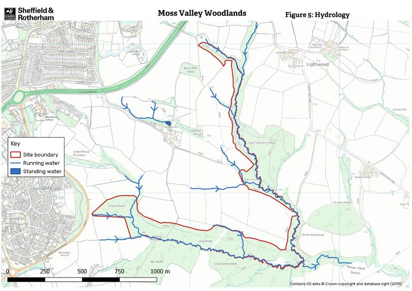
Summary
Moss Valley Woodlands nature reserve covers 26.3 hectares of semi-natural ancient woodland, grassland
and scrub. It lies on the southern fringes of the city, adjacent to Norwood and Owler Carr Wood, within the
Moss Valley. The woods are the property of Sheffield City Council and have been managed by the Sheffield
and Rotherham Wildlife Trust (SRWT) since 2001.

Moss Valley Woodlands is a semi-natural ancient woodland. Historical research and archaeological evidence
suggests that the woodland was managed as coppice with standards in the post-medieval period, reverting
to mature woodland with a beech and sycamore component by the Victorian period. Today the woods are
designated as a Local Wildlife Site and contain a Public Rights of Way network, including both footpaths and
concessionary bridleways, which provide access across the site. The reserve has long been used as a place
for recreation, and is enjoyed by local people for walking, picnicking and horse riding.

Moss Valley Woodlands nature reserve has numerous features of (biological) conservation interest,
including its areas of semi-natural ancient woodland, the ancient woodland ground flora, the semi-improved
grasslands of Dowey Lumb and several birds of conservation concern. Together with adjacent woods, their
age and continuity of use make the woodlands an important historical site which must be managed to ensure
that their unique characteristics, so appreciated by its users, are retained.

This management plan covers the period from April 2021 to March 2031. Physical works contained in the
plan are aimed at conserving and improving the priority habitats on the site and maintaining features of
interest. Works to maintain and improve recreational infrastructure are also included. A survey and
monitoring programme will be implemented over the course of the plan, providing data on ecological
conditions which will inform future management works.

In addition to these physical works, the Trust plans to engage the public in the management of the reserve
through the Reserve Advisory Group. On site information provision will be limited, rather the site will be
promoted through the Trust’s website. An annual programme of volunteer work days and guided walks will
be held to promote public understanding of its wildlife and history and offer opportunities to participate in
its management.

5
1.0 Introduction
Sheffield and Rotherham Wildlife Trust is part of a national association of 46 local Wildlife Trusts, which
work with communities throughout the UK to protect wildlife in town and country. Sheffield and Rotherham
Wildlife Trust aims to promote conservation, advance education in environmental matters, and improve the
quality of life in Sheffield and Rotherham, through the development and promotion of sustainable land
management practices, linked directly to both rural and urban regeneration.
Moss Valley Woodlands nature reserve covers 26.3 hectares of semi-natural ancient woodland, scrub and
grassland. The reserve lies on the southern fringes of city, adjacent to Norwood and Owler Carr woods,
within the Moss Valley area of Derbyshire. The woods are the property of Sheffield City Council and have
been managed by the Sheffield and Rotherham Wildlife Trust (SRWT) since 2002, for the purposes of
conservation and public recreation. The woods form part of the South Sheffield Greenway Living Landscape
area and act to combat climate change by acting as a carbon store and prevent flooding and soil erosion by
retaining and slowly releasing rainfall.
Purposes and formulation of the plan
This management plan has been formulated for the following reasons:
To provide comprehensive and cohesive information about the Local Nature Reserve in one
document, with reference to other documents where necessary.
To outline the key long-term aims and the associated objectives that form the framework of
management.
To outline the rationale for management so as to give a clear and comprehensive explanation of
why aspects need management and what form that management will take.
To provide a key document from which projects are developed and associated funding sought.
The plan allows consistency and continuity so that when changes of staff take place, or changes in
ownership or disposal of the land occurs, then management aims, objectives and prescriptions are
continued.
The work programme is set out within this document. However, the nature of work programmes is such
that they vary and are modified due to unanticipated changes or developments. Therefore, the full annual
work programmes are kept and updated electronically at the Sheffield and Rotherham Wildlife Trust office.
Structure of the plan
This management plan is divided into sections.
Section 1 gives an overview of the plan
Section 2 provides a detailed description of the reserve.
Section 3 of the plan gives the Trust’s vision for the reserve: the condition we are aiming to achieve by 2070.
It then lists the reserve’s features, the most valued elements of the site for which it is managed.
6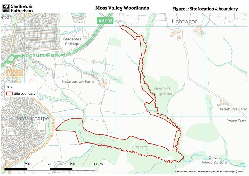
For each feature, a number of attributes and factors are then identified. Attributes are measurable qualities
of a feature, against which its condition will be monitored in order to judge the effectiveness of
management. Factors are anything that has the potential to influence or change a feature, or to affect the
way in which it is managed.

Once the attributes and factors affecting a feature have been identified, each feature is then evaluated.
During evaluation, the current condition of the feature is compared to that contained in the vision and its
performance against the attributes identified discussed. The impact of factors – which can be positive or
negative – on the feature, or its management, are likewise evaluated. From this evaluation management
objectives are then set.

Section 4 comprises the work programme where the management prescriptions for the features are listed.

Section 5 of the plan comprises the Figures: maps that accompany the text.

Section 6 of the plan are the Appendices, where supporting information is given.

7
2.0 Site Description
2.1    General Information

Location and extent
The Moss Valley Woodlands nature reserve is a narrow, linear group of woods extending in an
arc from Jordanthorpe to Norton, within the Moss Valley in the county of Derbyshire (Figure 1).
The reserve covers 26.3 hectares and includes Coalpit Wood (centred at SK 372 807, 3.6 ha),
Long Wood (centred at SK 378 808, 13.19 ha) and parts of Newfield Spring Wood (centred at SK
372 807, 6.5 ha) and Bridle Road Wood (centred at SK 374 813, 0.94 ha), but is continuous with
other woods in the area. It also includes 1.4 ha of grassland known as Dowey Lumb (centred at
SK 376 805).

Landscape value and context
Moss Valley Woodlands nature reserve falls inside Natural England’s Natural Character
Assessment (NCA) Profile 38: Nottinghamshire, Derbyshire and Yorkshire Coalfield. This NCA
is characterised by underlying shallow coal measures and consists of the relatively low-lying
land to the east of the Peak District National Park and the wool and engineering towns (in this
case Sheffield) of the South Pennine Fringe to the west.

The Moss Valley, including the nature reserve, lies on the Lower Coal Measures Series, and is
so underlain by bands of sandstone with (relatively) few coal seams. The result is a landscape
of broadly undulating wooded hills, valleys and small ridges. The valley soils are predominantly
heavy and seasonally wet. Crops are grown in free-draining areas, with cow pasture in wetter
areas. Remnants of ancient semi-natural woodland on steeper slopes or wet valley bottoms
are characteristic of the valley, which provides a number of ecosystem services for the area,
notably in terms of carbon sequestration, flood mitigation and recreational provision.

The Moss Valley is situated to the south of the city of Sheffield, with housing development to
the north and west. This contrasts sharply with the character of the valley itself, which has
retained a diverse mosaic of topographic features and vegetation types. The Moss Brook
meanders through a largely arable landscape, dissected by old hedgerows, ditches and scrub
belts. Linear belts of woodland, of which the reserve forms part, define the valley bottoms and
stream-sides. Together with the old lanes and packhorse routes, these woodlands now act as
corridors for the passage of people and wildlife across the modern-day, arable landscape.

The whole of the Moss Valley contains 280 hectares of woodland, which is 10% of the total of
woodland in lowland Derbyshire. Of this, 150 hectares is Ancient Semi Natural Woodland
(ASNW) or Plantation on Ancient Woodland Sites (PAWS).

                                               8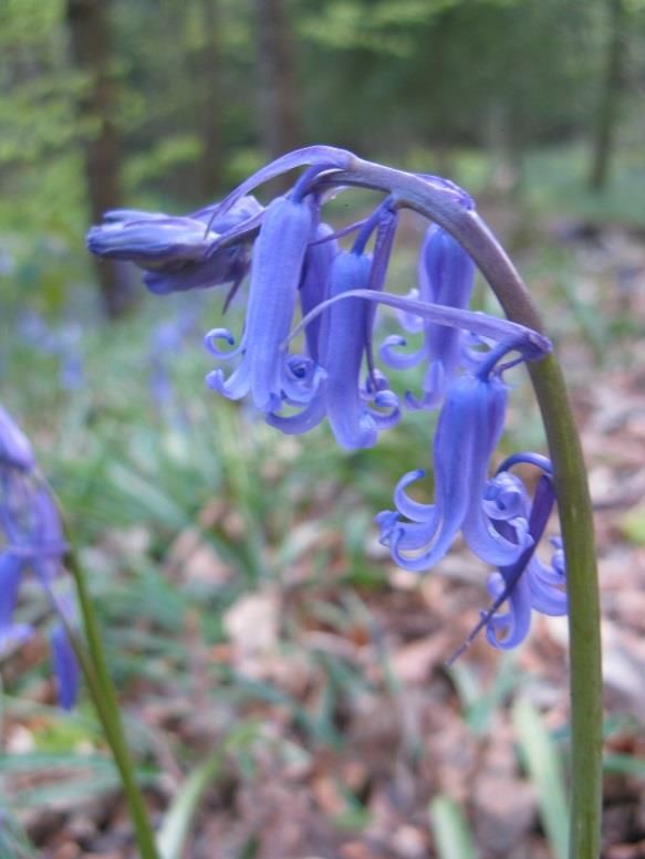
Site ownership and tenure
Moss Valley Woodlands nature reserve is owned by Sheffield City Council, but was let to
Sheffield and Rotherham Wildlife Trust on a long lease in 2002.
Designations and policy context
The Moss Valley, including the area covered by the reserve, is designated as the Moss Valley
Conservation Area (source: Derbyshire County Council). A Conservation Area is defined as "an
area of special architectural and historic interest, the character or appearance of which it is
desirable to preserve or enhance". In the execution of its duties as a planning authority, North
East Derbyshire District Council is required to pay special attention to the character and
appearance of its conservation areas when considering applications for planning permission.
The reserve’s woodlands have also been designated as a Wildlife Site by Derbyshire County
Council and Derbyshire Wildlife Trust. This local government designation is used to identify
sites of importance for nature conservation that lie within Derbyshire but outside of the Peak
District National Park and to offer them protection under the planning system. Long Wood and
Coalpit Wood are part of the Owler Car Wood Complex Wildlife Site (number N233), Dowey
Lumb is Wildlife Site number N270, and Newfield Spring Wood is Wildlife Site number N269. In
addition, the adjacent Whinacre Wood, to the south of Long Wood, is part of Moss Valley
Woods Site of Special Scientific Interest.
The lower (southern) section of Dowey Lumb is within the Moss Valley Floodzone (source:
Derbyshire County Council).
The reserve contains a complex network of Public Rights of Way (PROW), and a concessionary
bridle route (Figure 2). Both footpaths and bridleways pass through the reserve, linking it to a
much larger network covering the whole of the Moss Valley. The nature reserve falls under the
jurisdiction of Derbyshire County Council (DCC) in relation to Public Rights of Way.
The ‘Rights of Way Improvement Plan for Derbyshire (2007)’ sets out the Council’s approach
to PROW. Under this document, the Council recognises the health and recreational benefits
provided by access to the countryside, and the benefits to tourism and local economy. It aims
to “have an integrated, well managed and inclusive rights of way and access network which:
Encourages responsible enjoyment by residents and visitors alike.
Is a sustainable and safe network in keeping with the County’s heritage, landscape and
wildlife interests.
Promotes healthier lifestyles.
Helps support tourism and the local economy.
In the ‘Statement of Action (2013-2017)’ the Council highlights the need to provide a
connected, safe and accessible network, especially of bridleways, for users. The need to
prevent illegal use of the network is also recognised, as is the need to improve way-marking
and promote responsible use of the network.
9Site safety, security and maintenance
A site specific risk assessment has been written for the Moss Valley Woodlands and is reviewed
on an annual basis. Further risk assessments are prepared for specific tasks and events at the
site as necessary. The Trust also manages the reserve in line with its many detailed polices
covering environmental management and health and safety. These are amended and updated
at regular intervals or to reflect legislative changes.
The reserve is regularly patrolled by SRWT staff and volunteers. Any problems are logged and
addressed as soon as possible. Problems and incidents reported by members of the public are
also logged and are dealt with as necessary. Any known accidents or incidents that occur on
the reserve are recorded on the relevant accident forms at SRWT headquarters.
Tree inspections for the entire site are carried out every six years. Associated remedial work is
undertaken as recommended. An annual ash (Fraxinus excelsior) monitoring programme is also
in place.
The reserve’s boundaries are largely open and marked by physical features (such as the stream)
or a change of habitat type (from woodland to farmland). The boundaries of Coalpit and Long
Woods are partially marked and secured by drystone walls or fencing. Major access points to
the reserve are provided with gates, squeezes, and stiles as appropriate, to allow access by
legitimate users of the site whilst excluding entry by cars (other than management vehicles),
quad bikes and motorcycles.
No litter bins or dog waste bins are present on site, rather visitors are encouraged to take their
litter/dog waste home for disposal. The installation of litter/dog waste bins has been
discounted due to the cost of collections and a desire to keep the reserve as ‘wild’ as possible.
Littering and fire-lighting with associated littering can be a problem in both Coalpit and Bridle
Road Wood. Waste is cleared when reported and during regular litter picks.
Adjacent land ownership
Moss Valley Woodlands nature reserve lies on Sheffield’s urban fringe. Much of the land
surrounding the reserve is under cultivation and is owned or managed by various local farmers
(Figure 3). To the south and east, the reserve boundary abuts woodland. Cook Spring Wood,
Owler Carr Wood and Nor Wood are owned and managed by the Woodland Trust, with
Whinacre Wood and Newfield Spring Wood being privately owned (by two separate owners).
The farmland to the north of Coalpit Wood and Long Wood is owned by Sheffield City Council,
and farmed by a tenant farmer.
Past, recent and present land use
The land within and surrounding Moss Valley woodlands nature reserve has long been used and
modified by human activity.
10Evidence for Anglo-Saxon occupation of the Moss Valley and surrounding area can be inferred
from the frequency of Anglican suffixes in local place names, for example ‘ham’ meaning manor,
‘ton’ meaning farmstead and ‘ley’ or ‘leah’ meaning a glade or clearing.
In c.1183, Beauchief Abbey was founded by Robert Fitz Ranulph, Lord of Alfreton and Norton.
The Abbey was located some distance to the north-west of the reserve, on a site now on the
southern edge of Sheffield, but appears to have held land in the vicinity of the survey area. A
site at Hazelhurst, to the east of the survey area, was being used for iron smelting as early as
the late 12th century.
The history of Moss Valley, from the medieval period onwards, has been traced through
document and field evidence (EDAS, 2001). Much of the survey area was owned and managed
by the occupants of Hazelbarrow Hall (which preceded the farm on the same site) during the
early post medieval period, and it may be that the same arrangement was present during the
medieval period. In addition to the iron smelting activities of Beauchief Abbey, there is also
evidence to suggest that coal mining was undertaken in and around the reserve (Coalpit Wood)
during the medieval period.
Despite the evidence for earlier medieval industry both within and around the survey area,
there is little evidence for intensive or large-scale exploitation in the period after c.1500.
However, some evidence indicates early post-medieval industrial activity to the north–east of
Hazelbarrow Farm.
The exploitation of the reserve for coal appears to have ceased by the late medieval period but
was replaced by woodland management. Documentary evidence suggests that woodland
management formed an important industry in the Norton area from the mid 15th century
onwards. The numerous archaeological sites relating to the woodland management and
exploitation identified by the current survey suggest that this activity was most intense in Long
Wood, with outliers in parts of Newfield Spring Wood. The 35 ‘ackers’ of ‘Springe Wood’,
together with the ‘Tymber and Poles’ mentioned in the 1635 survey of Hazlebarrow Hall suggest
that woodland management was well established within the reserve and surrounding woodland
by the early 17th century. The use of the word ‘Springe’ in 1635 also indicates that this managed
woodland would have been coppiced. Archaeological evidence, place name evidence, historical
records and the reserve’s current ecology strongly suggest that coppicing was the traditional
management for these woodlands (coppice with standards was the management regime most
commonly practised in the Sheffield area). In South Yorkshire this was usually a coppice-with-
standards, which replaced wood pasture as the dominant form of economic exploitation of
woodland in south-west Yorkshire after the mid 15th century, although the use of wood for
herbage continued until at least the 18th century.
Although the extent of any woodland within the reserve is unclear before the early 19th
century, two sites associated with post-medieval woodland activity were found within a 500 m
radius of the boundary. These, together with the presence of ancient woodland indicator
species, suggest that the reserve’s woodlands are ancient in origin.
11Following its management as coppice for white coal production, the woodland was greatly
modified by the extensive planting of beech (Fagus sylvatica), sycamore (Acer pseudoplatanus)
and sweet chestnut (Castanea sativa) during the latter parts of the nineteenth century and the
early twentieth century.
Today, the Moss Valley Woodlands nature reserve lie within a largely agricultural landscape
(arable and pasture). The woodland complex itself is used for the purpose of nature
conservation, to provide ecosystem services for the surrounding area and for recreational
activities, such as walking and horse riding, and is a popular site for local naturalists who
provided many of the records summarised in this report.
Services and site access
An overhead mains electricity line runs in a north-south direction that bisects the two limbs of
the reserve (Figure 4). This has some management implications; the statutory undertakers for
this are Yorkshire Electricity Group plc. The areas that are affected include the northern section
of Newfield Spring Wood, and the middle of the Long Wood. Trees are removed as part of the
maintenance directly under the power lines.
A high-pressure mains gas line in a runs north-west to south-east through Dowey Lumb.
Water supply lines and fibre-optic telephone cables are not present on the reserve.
The original utility maps should be referred to before site works take place that may impact the
services. An on the ground check should also take place with a cable detector.
Public Rights of Way
A comprehensive network of footpaths and bridleways runs through Moss Valley Woodlands,
with numerous desire lines (non-statutory routes) that link the Public Rights of Way also present
(Figure 2). There are approximately 1 km of definitive footpaths within the reserve, and 0.7 km
of definitive or permissive bridleway.
The reserve is well linked in to the wider footpath and bridleway network in the valley.
122.2 Environmental Information
Topography
The reserve lies on the northern and western side, and along the bottom of the Moss Valley,
which runs east to west between the River Rother and Batemoor. The woodlands are low lying,
sloping down from a high point of 195 m above ordnance datum (AOD) at their northern tip, to
100 m AOD at the southern end of Bridle Road Wood.
Geology and pedology
The underlying geology of the Moss Valley is typical of the Lower Coal Measures Series, with
alternating beds of sandstones, and shales and mudstones, irregularly interspersed with coal
seams of varying depth.
The reserve’s pedology reflects the underlying bedrock, with acidic soils over the sandstone and
neutral to base-rich soils associated with the shales and mudstones.
Hydrology
The eastern and southern boundaries to the reserve are both formed by streams (Figure 5).
The Moss Brook, which runs from north to south through Bridle Road Wood, is classified by the
Environment Agency as a Grade 2 river, meaning it is relatively unpolluted. However, the
stream that flows through Long Wood is known to suffer occasional incidents of sewage
pollution from storm-water overflows on the adjacent Jordanthorpe estate.
Hillside spring-lines and seepages appear as groundwater issues at the base of the more porous
sandstone layers across the woodland, resulting in seasonally wet and waterlogged soils,
particularly in Long Wood.
Climate
The Moss Valley lies at the climatic northern limit for species with a southern distribution, and
the climatic southern limit for northern species of flora and fauna. Data is available for the
thirty-year average from the local Sheffield weather station, is presented below.
Temperature January July
Average (Celsius) 4.0 16.6
Rainfall January July
Average (mm) 88 51
The prevailing wind is from the west. The low-lying and sheltered position of the reserve’s
woodlands mean that windthrow is rarely an issue.
13Local sources maintain that the average annual temperature is rising. In addition local plants
are also believed to be flowering earlier on average. The rainfall in the region is approximately
800 mm per annum and is predicted to rise in future years (Sheffield Local Plan, 2015).
It should be noted that the woodland in Moss Valley, including that comprising the reserve, acts
to ameliorate the effects of extreme weather on a local level. During hot weather, the
woodland helps to temper the effect of the urban heat island created by the density of housing
in the vicinity. Equally, the woodland helps to reduce the risk both of flooding, soil erosion from
the adjacent farmland and landslide after heavy rainfall. Woodlands soak up and slowly release
heavy rains, with the tree roots and other vegetation binding the topsoil and preventing
erosion. Additionally, the woodland, and in particular the woodland soils, act as a carbon store,
therefore helping to combat climate change.
142.3 Biodiversity
Biodiversity Action Plans
Moss Valley falls within the area covered by the Peak Fringe Area Action Plan section of the
Lowland Derbyshire Biodiversity Action Plan. 2011 to 2020. The following Habitat Action Plans
are relevant to the reserve: Lowland mixed deciduous woodland, lowland meadow.
Table 1: BAP Priority habitats and species
Lowland Derbyshire Biodiversity Action Plan (BAP) Priorities
Habitat Action Plans Species associated with the habitats
Lowland mixed deciduous woodland White letter hairstreak (Strymonidia w-album)
Lowland meadow Freshwater white-clawed crayfish
(Austropotamobius pallipes)*
Rivers and streams
Skylark (Alaudia arvensis)*
Song thrush (Turdus philomelos)
Linnet (Carduelis cannabina)
Bullfinch (Pyrrhula pyrrhula)
Lesser spotted woodpecker (Dendrocopos
minor)*
Starling (Sturnus vulgaris)
Yellow Hammer (Emberiza citronella)
Pipistrelle Bat (Pipistrellus pipistrellus)
*species recorded in the Moss Valley but not recorded on reserve for at least 10 years
Habitats and species in bold are on the UK Priority Species and Habitats Action Plans, though
may be categorised differently. Of additional conservation interest are the woodland ancient
indicator species:
Bluebell (Hyacinthoides non-scripta), wood sorrel (Oxalis acetosella), wood anemone (Anemone
nemorosa), dog’s mercury (Mercurialis perennis), wood mellick (Melica uniflora), wood millet
(Millium effusum), yellow archangel (Lamiastrium galeobdolon), townhall clock (Adoxa
moschatellina), ramsons (Allium ursinum) and wild daffodils (Narcissus pseudonarcissus).
Habitats
The Moss Valley Woodlands nature reserve forms one part of a woodland complex, set in a
rural landscape which supports a wide variety of species-rich habitats (Figure 6). The reserve
encompasses Coalpit Wood, Long Wood, and parts of Bridle Road Wood and Newfield Spring
Wood. The boundaries of the nature reserve managed by Sheffield and Rotherham Wildlife
Trust do not encapsulate all of the Moss Valley woodlands (Figure 2) but do include a remnant
15of wood pasture – now semi-improved neutral grassland, bracken and scrub – known as Dowey
Lumb.
Woodland
The woodlands on the reserve all derive from semi-natural ancient oak (Quercus spp.) wood,
though greatly modified by the historic planting of sycamore (Acer pseudoplatanus), beech
(Fagus sylvatica) and sweet chestnut (Castanea sativa). Despite the woodland canopy being
greatly modified, the understorey and ground flora have remained largely intact. There are
several small areas of species-rich wet woodland adjacent to streams and along flush lines.
The component woodlands on the reserve are distinct in character and are therefore described
individually below, based on data gathered during the 2005 Phase I survey (Senkans, 2005):
Coalpit Wood (Cpt 450)
Coalpit Wood is at the western-most end of the reserve, has an even-aged canopy dominated
by sycamore, with abundant mature oak hybrids (Quercus petraea x rubra), occasional ash and
silver birch (Betula pendula), and (rarely) horse chestnut (Aesculus hippocastanum) and
common alder (Alnus glutinosa). The understory is well developed and bramble (Rubus
fruticosus) dominated, with occasional holly (Ilex aquifolium), hazel (Corylus avellana), wild
cherry (Prunus avium), rowan (Sorbus aucuparia) and elder (Sambucus nigra). The ground flora
is well developed but characteristically dominated by bluebells and creeping soft-grass, with
occasional yellow archangel, wood sorrel, and locally-dominant wood anemone. The ancient
woodland indicators yellow pimpernel (Lysimachia nemorum) and perforate St. John’s wort
(Hypericum perforatum) are also present. There is also a small wet flush within the centre of
the wood, with willow (Salix sp.), meadowsweet (Phillipendula ulmaria) and rushes (Juncus
spp.).
The combination of species suggests that this is W10 Quercus robur-Pteridium aqulinum-Rubus
fruticosus- Hyacinthoides non-scripta woodland.
An old hedge bank runs adjacent to a defunct drystone wall along the northern boundary of the
woodland. Fencing was erected in 2004 to prevent motorbike access to the woods, with some
shrub planting, has improved the woodland edge structure, providing a variety of heights and
densities, and acting as a buffer between the arable fields and the woodland. Though it is not
particularly diverse (it contains hazel, hawthorn and elder), it buffers the woodland flora from
effects of spray drift and fertiliser and also provides opportunities for nesting, roosting and
feeding for birds and small mammals including bats. This area of dense woodland edge shrubs
also prevents access by motorbikes from the adjacent farmland. A field margin exists between
the woodland edge and the crop; this is retained and managed as a cross-country course and
again helps to buffer the effects of arable farming on the woodland flora.
16Long Wood (Cpt 451a & b)
Long Wood is characterised by densely-spaced, mature and frequently drawn oak and beech
(W14 Fagus sylvatica-Rubus fruticosus community), forming a closed canopy and situated on a
moderate, south-facing slope. Large, mature rowan, sweet chestnut and wych elm (Ulmus
glabra) are occasional throughout. Individual yew (Taxus baccata), hornbeam (Carpinus
betulus), wild cherry and Corsican pine (Pinus nigra var. corsicana) are present in the area
adjacent to Dowey Lumb. The understorey in the majority of Long Wood is dominated by holly
which forms extensive haggs across the woodland. Localised areas of beech regeneration are
present. Hawthorn (Crataegus monogyna) is occasional, with hazel present along flush lines
and in areas adjacent to the stream. The drier parts of the wood, and the mid-slope also have a
few regenerating oak, sycamore and silver birch; these species are utilising the increased light
levels following windblow. In recent years large areas of dense holly have been mechanically
removed from the woodland creating tracts of bare ground.
Bluebell, creeping soft-grass, bramble and honeysuckle (Lonicera periclymenum) are
characteristic of the ground flora in drier areas of the woodland with an oak, ash or sweet
chestnut canopy. In areas of beech, the ground flora is characterised either by a dense layer of
beech mast, which excludes ground flora, or is absent due to the density of holly haggs. Where
holly has been removed in 2017 and 2019 the ground remains largely bare, although
recolonisation by grasses, bramble and tree seedlings is beginning to occur. Wavy hair-grass
(Deschampsia flexuosa) dominates the more acidic, steeper slopes. Beech is regenerating
sporadically across the woodland, in particular where the canopy has opened up due to tree
safety works and possibly as a result of the thinning.
Stands of semi-mature sycamore are concentrated in the area adjacent to the stream. In the
wet flushes adjacent to the stream course, the enriched soils support a variety of woodland
plants, including dog’s mercury (Mercurialis perennis), lesser celandine (Ranunculus ficaria),
greater stichwort (Stellaria holostea), wood anemone, wood millet (Millium effusum), marsh
marigold (Caltha palutrus), lady fern (Athyrium filix-femina) and ramsons. There are also ancient
woodland indicators present including yellow archangel, opposite-leaved golden saxifrage
(Chrysosplenium oppositifolium), yellow pimpernel, wood speedwell (Veronica montana),
sweet woodruff (Galium odoratum), wood sorrel and wood melick. This community is found in
compartment 451b, under the hazel coppice (Figure 7).
The woodland edge along Long Wood is structurally poor and species-poor in places. There is
little diversity of structure in the transition from mature trees to open field. The field margin
acts as the only buffer to spray drift and fertilisers. The woodland edge therefore offers limited
opportunities for feeding passerines, small mammals and invertebrates. However, the north-
westerly edge does contain a dense stand of guelder rose, which is scarce in the woodland itself.
Bridle Road Wood (452a)
Bridle Road Wood lies on a moderate to steep, east-facing valley side running down to the Moss
Brook. The woodland is predominantly sycamore- and beech-dominated to the north, with a
17canopy dominated by mature, well-crowned sessile oak, mature beech, frequent semi-mature
silver birch and occasional field maple (Acer campestre) and sycamore to the south, and an area
of scrub adjacent to Dowey Lumb..
The northern part of Bridle Road Wood has a canopy characterised by densely-spaced 60-80
year old sycamore, with frequent beech, occasional oak and ash forming a generally closed
canopy. Dead standing and fallen wych elm are frequent, and many of the elm stumps are
coppicing naturally. Apart from this, the understorey is poorly formed, with scattered pole-
stage beech and sycamore. Holly and hawthorn are present but rare. The northern section and
parts of the southern section are more closely associated with the W10 community (Quercus
spp. – Pteridium aquilinum – Rubus fruticosus).
To the south the canopy is open, with a well-developed understorey of hazel, blackthorn
(Prunus spinosa), dog rose (Rosa canina), holly (Ilex aquifiolium), hawthorn (Crataegus
monogyna) and crab apple (Malus sylvestris). Wood melick (Melica uniflora), wood barley
(Hordelymus europaeus), wood millet (Milium effusum), and barren strawberry (Potentilla
sterilis) are present in the ground flora. The ground flora also contains pignut (Conopodium
majus), marsh thistle (Cirsium palustre) and bitter vetch (Lathyrus linifolius). These species are
usually associated with open areas, and are probably remnants of when this area had a more
open character.
Elements of W7 (Alnus glutinoa-Fraxinus excelsior–Lysimachia nemorum) woodland community
are present along the Moss Brook.
As the woodland grades into Dowey Lumb, birch and hawthorn scrub become dominant, with
blackthorn (Prunus spinosa) forming locally dominant patches. The hawthorn here are old and
often multi-stemmed from historic coppicing.
The western edge of the wood runs along an ancient hedgerow bank, where there is coppiced
hazel, coppiced hawthorn and holly. The hedgerow at Bridle Road Wood contains a row of
mature ash, some of which have fallen but are re-growing, and also contains wild cherry, field
maple, and rose (Rosa sp). The hedgerow ground flora contains dog’s mercury, hogweed,
(Heracleum sphondylium), greater stitchwort (Stellaria holosteum), and wood sage (Teucrium
scorodonia).
Little woodland management has taken place in Bridle Road Wood over the past 45 years,
although tree safety works have been carried out as required.
Newfield Spring Wood (452b)
Newfield Spring Wood has a varied canopy characterised by beech, oak and sycamore. The
canopy is generally closed, and the woodland generally has a poorly-developed understorey,
although occasional thickets of holly, wych elm, bramble and birch are present. Tree
regeneration is sporadic throughout, the exception to this being the northern-most part of the
reserve where a good number of oak, beech and sweet chestnut saplings are growing. In
18steeper areas, the understorey has frequent rowan, hazel and silver birch. The ground flora
throughout the woodland is co-dominated by bluebell and creeping soft-grass, but is more
diverse adjacent to the stream, as in Long Wood. The woodland is W16 Quercus-Betula–
Deschampsia flexuosa woodland on the more acidic soils in the northern part of Newfield Spring
Wood. Small patches of W7 Alnus glutinosa-Fraxinus excelsior-Lysimachia nemorum woodland
are also present, adjacent to the River Moss. Elements of W14 Fagus sylvatica–Rubus fruticosus
exist in the southern part of Newfield Spring Wood.
The very northern, most beech dominated, part of the woodland was thinned, and beech
removed between 2002 and 2005. There has been a flush of oak regeneration as a result;
indicating that this thinning has achieved the objective of opening up the canopy to allow
natural regeneration of oak to occur.
Table 2: Summary of woodland management works since 2000
Year Woodland Management
2002 Coalpit Wood 10% canopy thin across woodland
2002-2005 Newfield Spring Woodland thinned favouring oak
Wood
2003 Bridle Road Wood Thinning of young woodland on boundary with Dowey
Lumb
2013 Coalpit Wood Under-planting of canopy with native shrubs to diversify
the understory
2015 Long Wood Recut hazel coppice in Compartment 451b
2015 Long Wood Group fell to create regeneration glades at the eastern
end of Compartment 451a
2017 Long Wood Halo thin of selected trees
2017 Long Wood Widespread holly clearance
2019 Long Wood Widespread holly clearance
19Wood Pasture (453)
Dowey Lumb is an area of grassland on a south facing slope at the south-eastern end of the site,
where the two branches of woodland meet. It is believed to be an area of relict woodland
pasture, though the area has not been grazed within living memory. Today, the Lumb supports
a diverse flora, with a number of plant communities characteristic of different habitats present,
as well as a range of fungi.
Elements of the woodland plant communities, including species such as bluebell, greater
stitchwort, wood anemone, wood sorrel, creeping soft-grass and red campion, are found across
the Lumb. These are growing interspersed with neutral grassland species such as Yorkshire fog
(Holcus lanatus), meadow foxtail (Alopecurus pratensis), rough and smooth meadow grasses
(Poa trivialis and P. pratensis), common knapweed (Centaurea nigra), common sorrel (Rumex
acetosa), bitter vetch (Lathyrus linifolius var. montanus) and cowslips (Primula veris). Pignut
(Conopodium majus) a species characteristic of old pasture, is present.
Species characteristic of acid grassland are also found on the Lumb. These include tormentil
(Potentilla erecta), heath bedstraw (Galium saxatile), lesser stitchwort (Stellaria graminea),
betony (Betonica officinalis) and slender St. John’s wort (Hypericum pulchrum).
In several areas across the Lumb, the soil is damp and species characteristic of wet grassland
and damp woodland dominate. Tufted hair-grass (Deschampsia cespitosa), wild angelica
(Angelica sylvestris), common valerian (Valeriana officinalis), marsh thistle (Cirsium palustre),
meadow-sweet (Filipendula ulmaria), sneezewort (Achillea ptarmica), oval sedge (Carex ovalis)
and creeping buttercup (Ranunculus repens) are all present, along with stands of compact rush
(Juncus conglomeratus) and rosebay willowherb (Chamerion angustifolium).
Bracken occurs across grassland areas of Dowey Lumb, although its vigour has been greatly
reduced by years of management and it no longer dominates the area.
20Watercourses
The reserve has a considerable freshwater resource, in the form of two streams that join to
form the River Moss, plus a number of seasonally-wet flushes. These support a varied flora;
plant communities along the streams are more diverse than in drier areas. Water quality in the
Moss Valley is recorded as being moderate to good. However, in times of high rainfall, the local
arrangement of surface-water drains and foul water sewers occasionally result in the discharge
of raw sewage into the brook.
A report written in 2002 on the water quality within the Moss Valley concluded that the stream
running southeast from the top of Long Wood was of medium quality, with some indication of
pollution. The stream running from the northern parts of the Moss Valley (Newfield Spring
Wood and Bridle Road Wood) to Dowey Lumb was found to be of good quality. The two
watercourses running into Coalpit Wood from Jordanthorpe Parkway were identified as very
polluted in this survey. The combination of the diversity of species present and aquatic indicator
species resulted in this conclusion.
Species
Fungi
The reserve’s fungal communities have been well surveyed, once in 2001 (Senkans, 2001) and
again in 2015 (Clements, 2015).
46 species were found in autumn 2001; some growing in abundance. The most prolific being
the Russula family, especially the common yellow russula (Russula ochroleuca), the charcoal
burner (R. cyanoxantha) and the blackish purple russula (R. atropurpurea). Long Wood was
particularly rich in these colourful mycorrhizal fungi, especially under areas where beech and
oak are plentiful.
In autumn 2015, 126 species of fungi were recorded on the reserve, placing it amongst the best
sites for fungi in the area. Newfield Spring, Bridle Road Wood, Long Wood were all rich in fungi,
due both to the species composition and prevalence of (fallen) dead wood. Dowey Lumb
supported a number of grassland fungi although the sward height is generally too long to be
ideal for these species.
Coalpit Wood was found to be less rich in fungi, due to lower quantities of dead wood (volumes
purposely kept low as this area suffers from petty vandalism and misuse such as fire-starting)
and the prevalence of bramble.
Invertebrates
A number of different invertebrate surveys have been carried out within Newfield Spring,
Bridle Road and Long Woods over the past two decades, and a number of casual records have
also been made. The most notable feature of the existing data is the presence of a high
percentage of ancient woodland indicator hoverflies. The Moss Valley is considered to support
21a very rich hoverfly fauna, with 15 species indicative of ancient woodland recorded up to 1987.
Newfield Spring Wood has 36 species of hoverfly with widely differing ecological niches. As
larvae, most are aphid predators but there are also species, such as Rhingia campestris, which
inhabit dung, Merodon equestris which feed on bulb species, species of decaying wood (Xylota
spp.) and the Eristalis spp which breed in water-filled rot holes and wet muddy pools. No
information for Coalpit Wood has been received but species present here will reflect the
composition found in the other areas of the reserve.
Most records from Dowey Lumb focus on hoverflies and Lepidoptera (mostly moths), with
some useful records of a small range of true bugs. Many of the hoverflies found had come from
adjacent woodland and wet habitats, visiting the Lumb to feed on the nectar of grassland
flowers. Examples include the ramsons hoverfly (Portevinia maculata), which is exclusively a
deciduous woodland species found where ramsons occur, as well as Criorhina ranunculi (first
recorded in 1984 and also in Long Wood), Brachypalpoides lenta and Xylota sylvarum. These
species are local or very local and weakly indicative of ancient woodland. Didea fasciata is more
strongly indicative and also nationally notable. Species characteristic of woodland margins,
such as Pipiza fenestrata are also present.
Both moths and butterflies have been recorded on the Lumb. Moths constitute the largest
group, with 85 species recorded to date, including some micro-moths. The majority are
common species, including generalists such as the swallow-tailed moth, the larvae of which
feeds on a wide variety of trees and shrubs. Other woodland and hedgerow species include
green oak tortrix (Tortrix viridana), the locally notable slender brindle (Apamea scolopacina)
whose larvae feed on woodland grasses, the rufous minor (Oligia versicolor) and scarce silver-
lines (Bena prasininana), which feeds mainly on oak. Nine species of pyralid moth, a mainly
grassland species, are present on the Lumb and caterpillars of the chimney sweeper moth
(Odezia atrata), which feed on pignut, were also recorded. An adult chimney sweeper moth
was recorded on Dowey Lumb in 2001.
The butterfly fauna of Dowey Lumb comprises many species common to the Sheffield area, such
as orange tip (Anthocharis cardamines), ringlet (Aphantopus hyperantus), green-veined white
(Pieris napi), small copper (Lycaena phlaeas), peacock (Inachis io) and gatekeeper (Pyronia
tithonus).
White-letter hairstreak, a Derbyshire BAP Priority species, has been recorded in the Moss Valley
in 1992 and 1998 but has not been recorded on the reserve. The closely related purple
hairstreak (Favonius quercus), an oak specialist, is present on the reserve.
A butterfly survey undertaken in 2001, concluded that the mature nature of the reserve’s
woodlands, with their closed canopies, limited their suitability as a habitat for many butterfly
species. The Lumb is considered of greater value due to its open but sheltered character, and
the range of sward heights and densities.
22White-clawed crayfish (Austropotamobius pallipes) are another BAP species historically present
in the valley but not present in the reserve’s streams, where the presence of signal crayfish
(Pacifastacus leniusculus) poses a long-term barrier to any recolonisation.
Fish
A number of Bullhead (Cottus gobio) and Brown Trout (Salmo trutta) were recorded in the
reserve’s streams. There were greater numbers in the northern tributary (running through
Bridle Road Wood) than in the southern tributary (running through Long Wood). In this
southern tributary, there were greater numbers in the eastern section than in the western
section, possibly due to higher levels of sewage pollution in the upper parts of this stream.
Amphibians and reptiles
Adder (Vipera berus), slow worm (Anguis fragilis) and great crested newt (Triturus cristatus)
have been recorded in Moss Valley but not within the reserve boundary. Grass snake (Natrix
natrix) has been recorded on the reserve, suggesting the presence of amphibians such as
common frog (Rana temporiaria) and/or Common Toad (Bufo bufo) in the area. More survey
work would be required to determine the location and extent of reptile and amphibian
populations locally.
Birds
Table 3: Birds of Conservation Concern
Red listed Amber listed
Woodcock Scolopax rusticola Mallard Anas platyrhynchos
Song thrush Turdus philomelos Stock dove Columba oenas
Lesser spotted Dendrocopus minor Bullfinch Pyrrhula pyrrhula
woodpecker*
Spotted flycatcher* Muscicapa striata
*species recorded in the Moss Valley but not recently recorded on reserve
The reserve’s breeding bird fauna were surveyed in 2002 and again in 2012 using the Common
Bird Census methodology. The species and populations recorded are, of course, a subsection
of the avifauna of the wider woodland. However, as recent survey data for Nor wood and Owler
Carr Wood is not available, the contribution of the reserve’s bird population to that of the
whole, and the relative suitability of habitats on the reserve to those in the wider area, cannot
be ascertained. Nevertheless, the Moss Valley nature reserve clearly supports a rich
assemblage of woodland birds.
The reserve’s bird communities reflect the opportunities for feeding and nesting within the
woodland. Seedeaters, such as linnet (Carduelis cannabina), a national BAP priority species,
greenfinch (Carduelis chloris) and goldfinch (Carduelis carduelis) form a relatively small
component of the assemblage, reflecting the paucity of feeding opportunities within the
reserve. However, species able to utilise beech mast, such as nuthatch (Sitta europea), are well
23catered for, and a good population of this species is present in the woodland. The woodlands’
holly, elder and hawthorn shrubs also support species such as bullfinch (Pyrrhula pyrrhula), and
song thrush (Turdus philomelos), both national Biodiversity Action Plan priority species, as well
as the commoner blackbird (Turdus merula).
Many insectivorous birds, such as chaffinch (Fringilla coelebs), robin (Erithacus rubecula), wren
(Troglodytes troglodytes), long-tailed tit (Aegithalos caudatus), blue tit (Parus caeruleus), and
treecreeper (Certhia familiaris) are common throughout the woodland. Great-spotted
woodpecker (Dendrocopus major), are regularly recorded. Occasional sightings of lesser-
spotted woodpecker (Dendrocopus minor) in the area suggest that this species may include the
reserve’s woodlands as part of its feeding range.
At the top of the food chain, tawny owl (Strix aluco), buzzard (Buteo bueo) and sparrowhawk
(Accipter nisus) have been recorded in the woodlands. Grey wagtail (Motacilla cineria) and
kingfisher (Alcedo atthis) have been recorded along the streams.
When data from the 2002 and 2012 breeding bird surveys were compared, it showed that many
of the species identified had comparable numbers of territories across the two surveys,
suggesting a stable bird community. Territory numbers were, however, significantly different
for 4 species. Looking at the data, it would appear that the number of breeding robins on the
reserve declined over the 10 years between surveys, whilst the breeding populations of
goldcrest, tree creeper, great tit and nuthatch increased over the same period.
Mammals
A number of common British mammals, including roe deer, badger, pipistrelle bat, fox, grey
squirrel and brown hare have been recorded on the reserve.
Grey squirrels are ubiquitous throughout the reserve and are the most often seen mammal.
The large populations of this species may, in the future, prove problematic in terms of tree
regeneration on the reserve as they are known to cause extensive damage to the bark of pole
stage beech.
Several badger setts are known and badger roam widely across the area. A full badger survey
for the reserve has been carried out. The results are lodged with Sheffield and Rotherham
Wildlife Trust. Badgers are constantly under threat from badger baiters. Sett protection
measures have been undertaken by the local badger group. Liaison, advice and protection
measures will be continued with the local badger group as required.
Sheffield’s roe and muncjac deer population has grown in recent years. Although both species
are found in the valley, populations are not thought to be large and may be being controlled by
local landowners.
Pipistrelle bats have been recorded on the reserve, feeding along the woodland edge and over
Dowey Lumb. No roosts have been found in the woodlands.
24You can also read