River Action Plan
     for the
Lower Collie River

       2008
←
→
Page content transcription
If your browser does not render page correctly, please read the page content below
River Action Plan
for the
Lower Collie River
2008
River Action Plan
         for the
    Lower Collie River

            Prepared for Leschenault Catchment Council

                                      by
                           Leigh Shinde-Taylor

                 Funded by the Natural Heritage Trust (NHT) and
      National Action Plan for Salinity and Water Quality (NAP), these are
joint initiatives of the State and Australian Government, which are administered
                       by the South West Catchments Council.
How to use this river action plan

This River Action Plan (RAP) was prepared for the Leschenault Catchment Council and landholders within the
Lower Collie River catchment. It contains a detailed description of the current health of the waterway, provides
information on current management issues, and recommends strategies to address the issues.

Landholders may find this a useful tool to help manage their waterways, while community groups may find it helpful
in prioritising actions to make the best use of limited resources. For others, it will provide background information
to aid decision making.

For Landholders
Landholders should turn to their relevant map in Chapter 5 and read the associated management issues and
recommendations. They should then read Chapter 4 to determine why these issues are considered to be a priority
for remediation, and Chapter 6 to determine the most appropriate actions to address the issues. Information on the
general study area and methodology used to develop this action plan can be found in Chapters 1, 2 and 3.

For the Leschenault Catchment Council
Turn to Chapter 5 as it contains detailed information on management issues for each stretch of the waterway.
Chapter 6 provides technical advice on how to best address and manage these management issues, and relevant
pages should be read carefully prior to implementing any actions.

Seven appendices provide further information that may be useful to landholders and community groups.
• Native vegetation of the Collie River Catchment
• Common weeds found in the study area
• Planning advice from the Vasse River Action Plan
• Permits Required Prior to Commencing Works In Rivers
• Landcare Project Time Line
• Best Management Practice (BMP)
• Useful contacts and phone numbers

Acronyms
RAP      River Action Plan
LCC      Leschenault Catchment Council
NHT      Natural Heritage Trust
DEC      Department of Environment and Conservation (previously CALM)
WRC      Water and Rivers Commission (now DoW)
DoW      Department of Water (previously DoE)
CALM     Department of Conservation and Land Management (now DEC)
DoE      Department of Environment (now DoW)

                                                                                                                    i
Acknowledgments
Cover photo: Lower Collie River, photo taken by Peter
Taylor                                                                  Thanks to Martin Olney from the Regional Support
                                                                        Branch of the Department of Environment for preparing
This River Action Plan was developed in consultation
                                                                        the maps. Special thanks to Jason Foster from
with Leschenault Catchment Council, and thanks are
                                                                        Department of Environment and Conservation for
extended to the community group for their assistance.
                                                                        providing information on the Wellington National Park.
Special thanks to Bree Skenner, Cassandra Jury, Mike
McKenna, Cameron Sutherland and Debbie Blake for
                                                                        Last but not least, I would like to express thanks to
their technical support.
                                                                        Peter Taylor, Robin Taylor and the Shinde family for
                                                                        their assistance in field assessments.
All of the landholders involved in the project, especially
those who took the time and effort to help with the
                                                                        This River Action Plan has drawn extensively from the
foreshore assessments and provide anecdotal and
                                                                        work of Genevieve Hanran-Smith in the Margaret River
historical information, deserve a big thank you, as do
                                                                        and, the Sabina, Abba and Ludlow Action Plans and
those who attended the community workshops and
                                                                        John McKinney’s work in the River Action Plan for
meetings. Special thanks to members of the community
                                                                        Ellen Brook .
that assisted in the foreshore assessments using canoes.
                                                                        The project was funded by the Natural Heritage Trust
Shirley Fisher and Mark Kennedy of the Leschenault
                                                                        and National Action Plan for Salinity and Water Quality,
Community Nursery assisted in the compilation of the
                                                                        these are joint initiatives of the State and Australian
species lists. Thanks also to Mel Strang of the
                                                                        Government, which are administered by the South West
Leschenault Catchment Council for help with plant
                                                                        Catchment Council.
identification.
                                                                        Reference details
Thanks to Tom Rose, Alan Pastega, Rosemary Lerch and
Artemis Kitsios from the Department of Water for                        The recommended reference for this publication is:
providing water quality data and information. Bill                      Leschenault Catchment Council, 2008, River Action
Bennell and Joe Northover are gratefully acknowledged                   Plan for the Lower Collie River, Leschenault Catchment
for their assistance in compiling the Indigenous heritage               Council.
of the area.                                                            ISBN: 978-0-9803056-3-0

©Copyright - Leschenault Catchment Council Inc
Permission to copy all or any part of this report is granted where the intention is not for commercial gain, and provided the source
is acknowledged.
Disclaimer:
While this document has been prepared in good faith and with all due care, servants and officers of the Leschenault Catchment Council
and contributing Western Australian government departments and agencies accept no responsibility for its accuracy, currency or
reliability or correctness caused by changes in circumstances after the time of publication or collection of the information in so far as it
incorporates information provided by a second or third party. Users of the document should obtain advice and conduct investigations and
assessments of any proposals that are being considered in the light of individual circumstances.

ii
Contents
How to use this River Action Plan . . . . . . . . . . . . . . . . . . . . . . . . . . . . . . . . . . . . . . . . . . . . . . . . . . . . . . . . . . . . ii
For landholders . . . . . . . . . . . . . . . . . . . . . . . . . . . . . . . . . . . . . . . . . . . . . . . . . . . . . . . . . . . . . . . . . . . . . . . . . . . . . ii
For the Leschenault Catchment Council . . . . . . . . . . . . . . . . . . . . . . . . . . . . . . . . . . . . . . . . . . . . . . . . . . . . . . . . . . ii

Acknowledgments . . . . . . . . . . . . . . . . . . . . . . . . . . . . . . . . . . . . . . . . . . . . . . . . . . . . . . . . . . . . . . . . . . . . . . . . iii

Contents . . . . . . . . . . . . . . . . . . . . . . . . . . . . . . . . . . . . . . . . . . . . . . . . . . . . . . . . . . . . . . . . . . . . . . . . . . . . . . . iv

Summary. . . . . . . . . . . . . . . . . . . . . . . . . . . . . . . . . . . . . . . . . . . . . . . . . . . . . . . . . . . . . . . . . . . . . . . . . . . . . . . . 6
General recommendations to improve the health of the lower Collie River . . . . . . . . . . . . . . . . . . . . . . . . . . . . . . . 6

1. Introduction . . . . . . . . . . . . . . . . . . . . . . . . . . . . . . . . . . . . . . . . . . . . . . . . . . . . . . . . . . . . . . . . . . . . . . . . . . . 9
Background. . . . . . . . . . . . . . . . . . . . . . . . . . . . . . . . . . . . . . . . . . . . . . . . . . . . . . . . . . . . . . . . . . . . . . . . . . . . . . . . . 9
Study aims . . . . . . . . . . . . . . . . . . . . . . . . . . . . . . . . . . . . . . . . . . . . . . . . . . . . . . . . . . . . . . . . . . . . . . . . . . . . . . . . . 9

2. Study area. . . . . . . . . . . . . . . . . . . . . . . . . . . . . . . . . . . . . . . . . . . . . . . . . . . . . . . . . . . . . . . . . . . . . . . . . . . . 10
The river system . . . . . . . . . . . . . . . . . . . . . . . . . . . . . . . . . . . . . . . . . . . . . . . . . . . . . . . . . . . . . . . . . . . . . . . . . . . . 10
Climate . . . . . . . . . . . . . . . . . . . . . . . . . . . . . . . . . . . . . . . . . . . . . . . . . . . . . . . . . . . . . . . . . . . . . . . . . . . . . . . . . . . 11
Landforms and Soils . . . . . . . . . . . . . . . . . . . . . . . . . . . . . . . . . . . . . . . . . . . . . . . . . . . . . . . . . . . . . . . . . . . . . . . . . 11
Threatened Flora and Fauna . . . . . . . . . . . . . . . . . . . . . . . . . . . . . . . . . . . . . . . . . . . . . . . . . . . . . . . . . . . . . . . . . . 12
Heritage. . . . . . . . . . . . . . . . . . . . . . . . . . . . . . . . . . . . . . . . . . . . . . . . . . . . . . . . . . . . . . . . . . . . . . . . . . . . . . . . . . . 14

3. Study methodology. . . . . . . . . . . . . . . . . . . . . . . . . . . . . . . . . . . . . . . . . . . . . . . . . . . . . . . . . . . . . . . . . . . . . 15
River foreshore condition assessment . . . . . . . . . . . . . . . . . . . . . . . . . . . . . . . . . . . . . . . . . . . . . . . . . . . . . . . . . . . 15
Community involvement . . . . . . . . . . . . . . . . . . . . . . . . . . . . . . . . . . . . . . . . . . . . . . . . . . . . . . . . . . . . . . . . . . . . . 18

4. Management issues. . . . . . . . . . . . . . . . . . . . . . . . . . . . . . . . . . . . . . . . . . . . . . . . . . . . . . . . . . . . . . . . . . . . . 18
Water Quality Issues. . . . . . . . . . . . . . . . . . . . . . . . . . . . . . . . . . . . . . . . . . . . . . . . . . . . . . . . . . . . . . . . . . . . . . . . . 20
Erosion & Sedimentation . . . . . . . . . . . . . . . . . . . . . . . . . . . . . . . . . . . . . . . . . . . . . . . . . . . . . . . . . . . . . . . . . . . . . 23
Stock access . . . . . . . . . . . . . . . . . . . . . . . . . . . . . . . . . . . . . . . . . . . . . . . . . . . . . . . . . . . . . . . . . . . . . . . . . . . . . . . 23
Loss of native fringing vegetation . . . . . . . . . . . . . . . . . . . . . . . . . . . . . . . . . . . . . . . . . . . . . . . . . . . . . . . . . . . . . . 23
Weed invasion . . . . . . . . . . . . . . . . . . . . . . . . . . . . . . . . . . . . . . . . . . . . . . . . . . . . . . . . . . . . . . . . . . . . . . . . . . . . . 24

5. River foreshore condition and recommendations for management . . . . . . . . . . . . . . . . . . . . . . . . . . . . . . . . 25
Using the maps . . . . . . . . . . . . . . . . . . . . . . . . . . . . . . . . . . . . . . . . . . . . . . . . . . . . . . . . . . . . . . . . . . . . . . . . . . . . . 25
Management recommendations . . . . . . . . . . . . . . . . . . . . . . . . . . . . . . . . . . . . . . . . . . . . . . . . . . . . . . . . . . . . . . . . 25
Reach 1 . . . . . . . . . . . . . . . . . . . . . . . . . . . . . . . . . . . . . . . . . . . . . . . . . . . . . . . . . . . . . . . . . . . . . . . . . . . . . . . . . . . 26
Reach 2 . . . . . . . . . . . . . . . . . . . . . . . . . . . . . . . . . . . . . . . . . . . . . . . . . . . . . . . . . . . . . . . . . . . . . . . . . . . . . . . . . . . 27
Reach 3 . . . . . . . . . . . . . . . . . . . . . . . . . . . . . . . . . . . . . . . . . . . . . . . . . . . . . . . . . . . . . . . . . . . . . . . . . . . . . . . . . . . 29
Reach 4 . . . . . . . . . . . . . . . . . . . . . . . . . . . . . . . . . . . . . . . . . . . . . . . . . . . . . . . . . . . . . . . . . . . . . . . . . . . . . . . . . . . 30

6. Management advice - What can be done? . . . . . . . . . . . . . . . . . . . . . . . . . . . . . . . . . . . . . . . . . . . . . . . . . . . 32
Where to start . . . . . . . . . . . . . . . . . . . . . . . . . . . . . . . . . . . . . . . . . . . . . . . . . . . . . . . . . . . . . . . . . . . . . . . . . . . . . . 32
Stock control. . . . . . . . . . . . . . . . . . . . . . . . . . . . . . . . . . . . . . . . . . . . . . . . . . . . . . . . . . . . . . . . . . . . . . . . . . . . . . . 32
Water quality . . . . . . . . . . . . . . . . . . . . . . . . . . . . . . . . . . . . . . . . . . . . . . . . . . . . . . . . . . . . . . . . . . . . . . . . . . . . . . 33
Erosion control . . . . . . . . . . . . . . . . . . . . . . . . . . . . . . . . . . . . . . . . . . . . . . . . . . . . . . . . . . . . . . . . . . . . . . . . . . . . . 35
Regeneration and revegetation . . . . . . . . . . . . . . . . . . . . . . . . . . . . . . . . . . . . . . . . . . . . . . . . . . . . . . . . . . . . . . . . . 37
Weed control . . . . . . . . . . . . . . . . . . . . . . . . . . . . . . . . . . . . . . . . . . . . . . . . . . . . . . . . . . . . . . . . . . . . . . . . . . . . . . 39
Feral animal control . . . . . . . . . . . . . . . . . . . . . . . . . . . . . . . . . . . . . . . . . . . . . . . . . . . . . . . . . . . . . . . . . . . . . . . . . 43

                                                                                                                                                                               iii
7. Implementation of Management Techniques on the Lower Collie River . . . . . . . . . . . . . . . . . . . . . . . . . . . . 45

8. References. . . . . . . . . . . . . . . . . . . . . . . . . . . . . . . . . . . . . . . . . . . . . . . . . . . . . . . . . . . . . . . . . . . . . . . . . . . . 48

Appendix 1. Native vegetation of the Lower Collie River Catchment . . . . . . . . . . . . . . . . . . . . . . . . . . . . . . . . 51
Appendix 2. Common weeds found in the study area . . . . . . . . . . . . . . . . . . . . . . . . . . . . . . . . . . . . . . . . . . . . 53
Appendix 3. Planning advice from the Vasse River Action Plan . . . . . . . . . . . . . . . . . . . . . . . . . . . . . . . . . . . . 55
Appendix 4. Permits Required Prior to Commencing Works in Rivers. . . . . . . . . . . . . . . . . . . . . . . . . . . . . . . 58
Appendix 5. Landcare Project Time Line . . . . . . . . . . . . . . . . . . . . . . . . . . . . . . . . . . . . . . . . . . . . . . . . . . . . . . 60
Appendix 6. Best Management Practice (BMP). . . . . . . . . . . . . . . . . . . . . . . . . . . . . . . . . . . . . . . . . . . . . . . . . 61
Appendix 7. Useful contacts and phone numbers . . . . . . . . . . . . . . . . . . . . . . . . . . . . . . . . . . . . . . . . . . . . . . . 65

LIST OF FIGURES
Figure 1 Study area
Figure 2 Annual total rainfall for south west Western Australia
Figure 3 Loads, Status and Medians in the Collie Catchment (From DOE, 2006)
Figure 4 The correct placement of fences in relation to the river valley
Figure 5 Outside bend bank erosion
Figure 6 The use of structural works will prevent the process of undercutting
Figure 7 The process of bank slumping caused by excessive weight and lack of support
Figure 8 Repositioning large woody debris

LIST OF DIAGRAMS
Diagram 1 The four grades of river foreshore condition – (A) pristine to ditch (D)

LIST OF TABLES
Table 1 Summary Foreshore Condition rating for Lower Collie River
Table 2 Length of fenced areas of Lower Collie River
Table 3 Water Quality Data for Lower Collie River

iv
Summary
The Collie River is located in the Leschenault              General recommendations to improve
Catchment area. The Collie River has a catchment of         the health of the lower Collie River
2920 square kilometres it extends approximately 154km
inland from the coast. The river is generally referred to   It is recommended that landholders consider the
as the Upper Collie River (the section above the            following:
Wellington Dam) and the Lower Collie River (below the
                                                            • Retain and protect the remaining riparian vegetation
Wellington Dam). This study is of the Lower Collie
                                                              of lower Collie River;
River that is approximately 45km in length and
discharges into the Leschenault Estuary near Eaton.         • Fence the river to better control stock access;

The aim of this RAP is to provide information to            • Use available funding to contribute towards the
landholders, interested community members, and                costs of fencing and rehabilitation projects;
organisations on the health and current state of the
                                                            • Control weeds, particularly invasive species in the
Lower Collie River and recommendations on how to
                                                              riparian zone;
improve its management for the future.
                                                            • Implement best management practices that
Assessments were carried out in September and October
                                                              minimise soil erosion and nutrient loss to waterways
2007 using the Foreshore Condition Assessment
                                                              such as soil testing and maximising vegetation cover
method developed by Dr Luke Pen and Margaret Scott
                                                              on the soil;
for rivers in the South-West of Western Australia (Pen
& Scott, 1995). Many landholders assisted with the          • Revegetate waterways with local native species to
foreshore surveys.                                            provide habitat and enhance ecological function;
A summary of the foreshore condition ratings and            • Use available funding and resources to control feral
length of fencing of the river is presented in Tables 1       animals.
and 2.
                                                            It is recommended that the Leschenault Catchment
Key issues identified                                       Council consider the following:
The key issues of concern identified during the             • Encourage and support community efforts to fence
foreshore assessments and community consultations             the River to restrict stock access;
were:
                                                            • Apply for further funding to continue to subsidise
• Loss of native fringing vegetation and degradation of       the cost of revegetation projects and fencing;
  remaining vegetation;
                                                            • Encourage, as a priority, the protection of areas of
• Weed invasion;                                              the river still retaining native fringing vegetation. It
                                                              is more cost effective to protect these areas now than
• Erosion and sedimentation of the waterway;
                                                              to restore them later after further degradation has
• Water quality issues, including nutrient enrichment,        occurred;
  pollution and salinity;
                                                            • Provide encouragement and support to landholders
• Impact of urban development on the water quality;           to undertake revegetation using a diverse suite of
                                                              local native species (including trees, shrubs, sedges,
• Need for assistance if landholders are to protect and
                                                              rushes, herbs and native grasses);
  enhance the foreshore by fencing or revegetating;
                                                            • Expand and continue to support weed and feral
• Impact of feral animals;
                                                              animal control projects in the catchment;
• Impact of tourists and visitors to public areas.

                                                                                                                page 1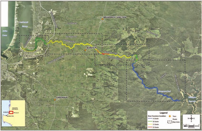
• Promote best management practice techniques that              • Promote the use of “clean site” building techniques
  minimise soil erosion and nutrient loss to waterways            to reduce the impact of urban development on the
  such as buffer strips, soil testing and fertiliser              water quality of the Lower Collie River;
  management plans, and maximising vegetation
                                                                • Encourage local government and developers on the
  cover on the soil;
                                                                  Lower Collie River to implement Foreshore
• Work with landholders, and engineers from the                   Management Plans in an effective manner;
  Department of Environment to address serious
                                                                • Encourage the use of Environmental Water
  erosion and sedimentation problems;
                                                                  Requirements when determining water extraction
• Work with Department of Environment to expand                   and allocations;
  their water monitoring program of the Lower Collie
                                                                • Encourage the use of Best Management Practices on
  River to address community concerns in regards to
                                                                  rural drains;
  nutrient levels, contamination and salinity;
                                                                • Encourage the implementation of the Wellington
• Encourage the use of Water Sensitive Urban Design
                                                                  National Park and Westralia Conservation Park
  in new and existing residential developments;
                                                                  Draft Management Plan 2005.

Condition                                           Total Length                    Total %
A (pristine)                                        15.8km                          35%
B (weedy)                                           9km                             20%
C (erosion prone/eroding)                           19km                            42%
D (ditch)                                           1.2km                           3%
Table 1: Summary of foreshore condition rating of Lower Collie River

                                                    Length Fenced                    % Of Length
North/Right Bank (facing downstream)                9.1km                            20 %
South/Left Bank (facing downstream)                 15.5km                           32.8 %
Total Fenced                                        24.6km                           26.5 %
Table 2: Length of fenced areas on Lower Collie River

page 2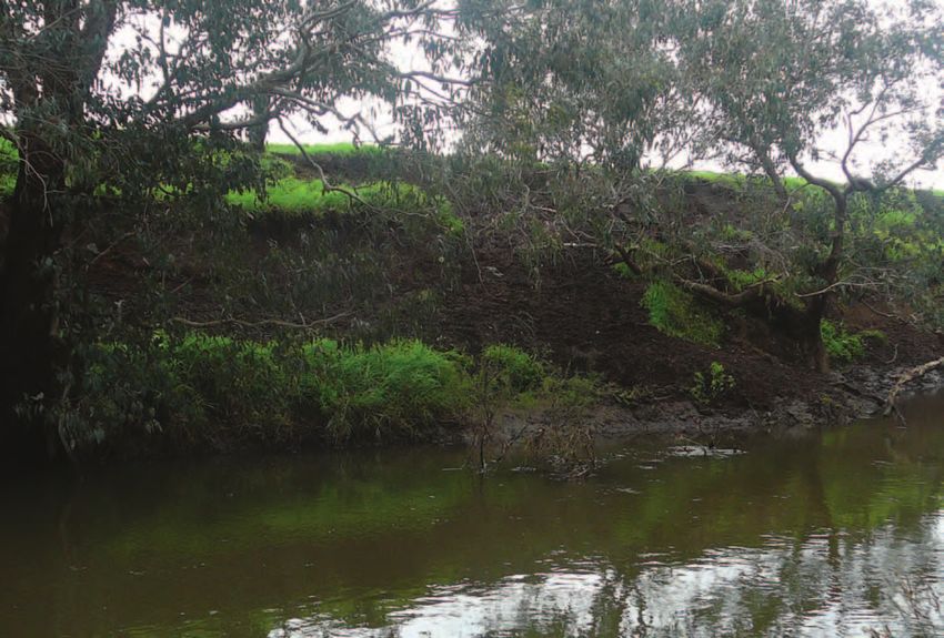
1. Introduction
Background                                                Study Aims
The Leschenault Catchment Council is an incorporated      The primary aims of this River Action Plan are:
community-based body that works in partnership with
                                                          • To produce a detailed description of the current state
government agencies, local government, industry and
                                                            of the Lower Collie River and identify priority
community groups to share awareness and
                                                            actions which guide works and help improve the
responsibilities in determining natural resource
                                                            health of these waterways;
management issues and their solutions within the
catchment.                                                • To help increase the community’s awareness of the
                                                            importance of healthy waterways and riparian
The Council was formed in 2000, through the
                                                            vegetation;
amalgamation of two community-lead NRM groups -
the Leschenault Inlet Management Authority and the        • To provide a benchmark against which the local
Leschenault Catchment Coordinating Group. It has ten        community’s future catchment work, to protect and
community, two local government, two industry and           rehabilitate the waterways, can be gauged;
two State government representatives and links to many
other groups.                                             • To provide guidance on the possibility of funding
                                                            and assistance available for fencing, weed and
The Leschenault subregional boundaries encompass the        erosion control, and the planting and rehabilitation
Leschenault Estuary and the Preston, Collie, Ferguson,      of native vegetation; and
Wellesley and Brunswick River systems and the
Wellington Dam and its catchment, the upper Collie        • To provide a sound technical basis for future funding
River.                                                      or project submissions.

Its charter is:

‘To develop ways to achieve a sustainable, healthy and
productive catchment in partnership with the
community.’

In recognition of the need to address the poor state of
the rivers in the South West region, the project was
funded by South West Catchment Council through the
Improving Waterways Health Program of the SW
Investment Plan, the basis of this program is:

“To bring about the improvement of the health of the
Regions waterways”

                                                                                                            page 3
2. Study area
page 4
Figure 1: Study area.Catchment Description many farmers water their stock and orchards from the
River. The Lower Collie River and its tributaries were
The Lower Collie River starts at the Wellington Dam proclaimed under the RIWI Act in 1954 , thus all
and flows through approximately 10.5km of pristine surface water abstraction from the river and tributaries
National Park before reaching Burekup Weir. The require a licence from DoW. However, stock watering
Catchment west of Burekup weir to the Burekup and domestic use are excluded from licensing as a
townsite can be described in general as undulating hills Riparian right.
with medium to high clearing. As the Lower Collie
River flows west from Burekup to Australind Bypass, Upstream of the Burekup Weir, Wellington National
passing across the Swan Coastal Plain, the catchment Park covers the majority of this area. The Wellington
quickly becomes flat with a high percentage of clearing. National Park is managed by the Department of
The Brunswick River flows into the Collie River at Point Environment and Conservation, and they have recently
Latour and the surrounding catchment displays an prepared a Draft Management Plan for the Wellington
increase in vegetation as much of the river is protected National Park and Westralia Conservation Park 2005.
by foreshore reserves. However, increasing residential
Climate
development is placing pressure on this river system as
it discharges into the Leschenault Estuary. The area has a Mediterranean-type climate,
characterised by warm, dry summers and cool, wet
The river system winters. The Collie area experiences an average annual
For this study, Lower Collie River was considered to rainfall of 940mm (Bureau of Meterology, 2005).
include the main channel but does not include its
There is data that supports, the anecdotal evidence from
tributaries. The Lower Collie River extends
landholders, of decreased rainfall. It shows a 10-25 %
approximately 45km from the Wellington Reservoir and
decline in annual rainfall in the south west of Western
discharges into the Leschenault estuary.
Australia from the long-term climate mean (Hennessy,
The Lower Collie River is classified as a “T3” river type 2002). Figure 2 shows that since circa 1970 there has
which means it’s a “shorter river originating in the been a clear reduction in total annual rainfall. This is
higher rainfall Jarrah/Marri forest before descending the due to a reduction in the mean number of raindays, and
Darling Scarp to the coastal plain to the sea” (WRC the mean number of heavy raindays in winter.
2/92) According to the State Water Strategy (Government of
Western Australia, 2003) ‘Climate change has
Approximately 45km of foreshore was assessed and the contributed to a 10-20 percent reduction in rainfall in
location of the study area is shown in Figure 1. the south-west of the State over the last 28 years, a
subsequent 40-50 percent reduction in run-off into our
Landuse Description
dams and reduced recharge of groundwater’.
Urban development fringes the Lower Collie River west
of the Australind Bypass, the river foreshore in this area
being vested with the Shire of Harvey (right foreshore),
Shire of Dardanup (left foreshore) or State Government.
The major landuse east of the Australind Bypass is beef
and sheep farming with one Turf Farm near the South
West Highway. Landuse upstream from the highway is
again mainly beef farming, however there is an increase
in orchards (mainly citrus) and one winery. The
majority of the river foreshore is privately owned and
page 51300
10-year moving average
1200
1110
1000
Annual Rainfall (mm)
900
800
700
600
500
1884 1894 1904 1914 1924 1934 1944 1954 1964 1974 1984 1994
Figure 2: Annual total rainfall for south west Western Australia. Source Hennessy (2002).
Landforms and Soils sand dunes and sandplains with flats and swamps. The
geology is sandy alluvium over sedimentary rocks. The
The upper catchment soils of the Lower Collie River are soils are pale deep sand, semi-wet soil and wet soil.
dominated by Lowden landforms with steep slopes and
lateritic soils with rocky outcrops. The lower catchment The Lowden Valleys System on the Western Darling
area on the coastal plain is more dominated by the Range, extends from Harvey to Bridgetown. The
Pinjarra, Vasse and Bassendean landforms. The landform is deeply incised valleys. The Geology is
following description of these landform taken from colluvium over metasediments and granitic rocks. The
AgMaps Land Manager 2005, for the shires of soils are friable red/brown loam earths, brown loamy
Serpentine-Jarrahdale, Kwinana, Rockingham, earths, loamy gravels, brown deep loamy duplexes,
Mandurah, Murray, Boddington, Waroona and Harvey, duplex sandy gravels and stony soils.
can be seen below.
Vegetation communities
The Pinjarra System extends along the Swan Coastal
Known Vegetation Complexes taken from Regional
Plain from Perth to Capel. The landform is poorly
Forest Agreement Vegetation Complexes, (Mattiske and
drained coastal plain. The geology is alluvium over
Havel 1998)
sedimentary rock. The soils are semi-wet soils, grey
deep sandy duplexes, brown loamy earths, pale sands Upper Catchment
and clays.
Murray 1 - Open forest of Eucalyptus marginata subsp.
The Vasse System extends along the Swan Coastal Plain marginata - Corymbia calophylla- Eucalyptus patens
from Perth to Dunsborough. The landform is estuaries, (blackbutt) on valley slopes to woodland of Eucalyptus
swampy depressions and poorly drained flats. The rudis - Melaleuca rhaphiophylla on the valley floors in
geology is alluvium over sedimentary rocks. The soils humid and sub-humid zones.
are wet soils and pale deep sands.
Helena 1 (He1) - Mosaic of open forest of Corymbia
The Bassendean System also extends along the Swan calophylla-Eucalyptus patens-Eucalyptus marginata
Coastal Plain, from Busselton to Jurien. The landform is subsp. marginata with some Eucalyptus rudis on the
page 6deeper soils ranging to closed heath and lithic complex Areas of blackberry and briar rose infestations have
on shallow soils associated with granite on steep slopes been known to be attractive to possums as they can
of valleys in humid and subhumid zones. provide food and extra protection from predators.
Lowdon – Open forest of Corymbia calophylla (marri) - • Common Brushtail possum Trichosurus vulpecula
Eucalyptus marginata subsp. Marginata (jarrah) - Agonis (not threatened) outside and within riparian habitat
flexuosa (peppermint) with some Eucalyptus wandoo where eucalypt species with hollows are present.
(wandoo) and occasional Corymbia haematoxylon
• Brushtail Phascogale Phascogale tapoatafa (DEC
(mountain marri) on slopes, and woodland of
Priority 3) where eucalypt species with hollows are
Eucalyptus rudis (flooded gum) - Melaleuca
present.
rhaphiophylla (swamp paperbark) on valley floors in the
humid zone. • Chuditch Dasyurus geoffroii (Vulnerable) have been
sighted and they reside in the Jarrah forest where
Lower Catchment
hollow logs on the ground are present for dens.
Swan Coastal Plain Vegetation includes salt-marsh
Birds
Sarcocornia quinqueflora (bearded samphire), Halosarcia
indica (shrubby glasswort), Juncus Kraussii (shore- • Forest Red-tailed Black Cockatoo Calyptorhynchus
rush), Melaleuca rhaphiophylla (swamp paperbark), banksii naso (Vulnerable) within adjacent forest.
Casuarina obesa (saltwater sheoak), Bolboschoenus
caldwellii (club rush) and Eucalyptus rudis (flooded • Baudins White-tailed Black Cockatoo Calyptorhynchus
gum). baudinii (Endangered) within adjacent forest.
Threatened Flora and Fauna • Eastern Curlew Numenius madagascariensis (DEC
Priority 4) at the river mouth.
The following information was provided by the
Department of Environment and Conservation Office, The species listed above are obtained from DEC
Bunbury. Corporate and Regional databases and from general
knowledge of species occurring in the area. Only those
These following threatened species are found in the threatened flora and fauna species within 100m of the
study area. Collie River are listed.
Threatened Flora Fish and freshwater crayfish
• Acacia oncinophylla subsp. Oncinophylla (DEC A fish study was conducted on the Lower Collie River in
Priority 3) March 2003 by Wetland Research and Management
(WRM) and a Draft Report was prepared for the Waters
• Diurus drummondii (Declared Rare Flora)
and Rivers Commission. The fish study found five
• Lasiopetalum membranaceum (DEC Priority 3) species of native fish, three species of introduced fish
and three species of decapods.
• Caladenia speciosa (DEC Priority 4)
Field sampling showed healthy populations of native
Threatened and other Fauna fish including the Freshwater cobbler, Nightfish,
Mammals Western minnow, Pygmy perch and Swan River goby.
Three species of introduced fish were recorded; the
• Southern Brown Bandicoot or Quenda Isoodon Mosquito fish, trout and Redfish perch, but only the
obesulus fusciventer (DEC Priority 5) within denser Mosquito fish was abundant (WRM 2004).
riparian habitat possibly including weedy areas.
Three species of freshwater crayfish (decapods) were
• Western Ringtail possum Pseudocheirus occidentalis found in the study. Freshwater prawns were found in
(Vulnerable) in pockets of peppermint and where good numbers at sites on the coastal plain, but present
eucalypt species with hollows are also present. in low numbers further upstream. Marron were most
page 7visible in the upper reaches of the river and very few This story told by John Sara with special thanks to
gilgies were caught overall. The low numbers of gilgies George E Webb (dec), elder Wardandi Tribe Busselton
may reflect effects of poor water quality and low habitat and Joseph Northover, Collie Nyungar.
condition (WRM 2004).
The entire Collie River is considered scared and is a
However, overall the water quality was found to be registered mythological site under the Aboriginal
reasonable at all sites surveyed by WRM, apart from a Heritate Act.
slightly elevated salinity. In general the upper reach
(upstream on Burekup weir) had high summer flows,
European heritage
deep pools, minimal siltation and supported a high In 1829 Dr Alexander Collie and Lieutenant William
loads on large woody debris. Where the lower reach Preston jointly discovered the Collie and Preston Rivers,
was much more degraded in which pool were infilling giving their surnames to the respective rivers. Dr
with silt accumulations (WRM, 2004). Alexander Collie could hardly have foreseen that a
town, some 40 km upstream from his nearest contact
Heritage
would also take his name (Williams 1979).
The Lower Collie catchment has significant Indigenous
Further exploration of the river occurred a year later
and non-Indigenous cultural heritage values.
when Lieutenant Governor Sir James Stirling expedition
Indigenous heritage recognised the potential of the land for agricultural.
The Collie River Valley was later used for beef and sheep
The Aborigines of the South West Region, prior to
grazing. In the early 1880’s coal was found near the
European contact, formed a distinctive socio-cultural
river and by the late 1880’s the area around Collie was
group collectively known as Nyungar (O’Connor et al.,
recognised for its coal resources (CALM, 2005).
1995). A painting by John Sara tells the story of how
the Ngarngungudditj Wargal or Hairy Faced snake came Collie has grown to be one of the most important
down from the north of Collie a long time ago, to form mining towns in the State, supplying coal and from
the Rivers within the Leschenault Catchment. 1961 for the generation of electricity (CALM, 2005).
Following the discovery of coal and the development of
“The snake came down through Collie creating the hills
transport facilities the increased infrastructure
and rivers down to Turkey Point (Australind- Pelican
stimulated the timber industry (Williams, 1979). The
Point area) and Eelaap (Bunbury). He pushed his big
mills provided timber to the mining industry and the
body and turned to form the estuary and Koombana Bay.
railways, two of these mills that began operation in the
He then came back up the Collie River to a place called
1940’s are still in operation today (CALM, 2005).
Minninup pool. When the moon is high in the sky you
can see his spirit resting there. In 1931 the Wellington Dam was constructed for the
Collie Irrigation Scheme, at the time of its construction
Koombana Bay (before the Breakwater Rocks had
it was the largest dam in Western Australia (CALM
begun) was a beautiful sea bay front from the ocean and
2005).
Turkey Point was an Aboriginal ceremony camping
hunting and corroboree ground. The Wargal is the great
mythical snake that controls the lives, actions, totems
and beliefs of the Nyungar people”
page 83. Study methodology
River foreshore condition assessment C grade foreshore: Erosion prone to eroded
The Pen-Scott method of riparian zone assessment was C1 Erosion prone - trees remain, possibly with some
used for the foreshore assessment. This system provides large shrubs or grass trees, but the understorey
a graded description of the river foreshore from pristine consists entirely of weeds, mainly annual grasses.
(A grade) through to ditch (D grade). A summary of the Most of the trees will be of only a few resilient or
grades of the Pen-Scott system follows (Pen & Scott, long-lived species and their regeneration will be
1995; Water and Rivers Commission, 1999a). These are almost negligible. In this state, where short-lived
illustrated in Figure 3 and photos on the following weeds support the soil, a small increase in physical
pages. This method allows comparisons of waterway disturbance will expose the soil and render the river
health across the south west of Western Australia, and valley vulnerable to serious erosion.
can be used to prioritise actions.
C2 Soil exposed - annual grasses and weeds have
A grade foreshore: Pristine – near pristine been removed through heavy livestock damage and
A1 Pristine - embankments and floodway are grazing, or other impacts such as a result of
entirely vegetated with native species and there is recreational activities. Low level soil erosion has
no evidence of human presence or livestock begun, by the action of either wind or water.
damage. C3 Eroded - soil is being washed away from
A2 Near pristine - native vegetation dominates but between tree roots, trees are being undermined and
introduced weeds are occasionally present in the unsupported embankments are subsiding into the
understorey, though not to the extent that they river valley.
displace native species.
A3 Slightly disturbed - areas of localised human D grade foreshore: Ditch to drain
disturbance where the soil may be exposed and
weed density is relatively heavy, such as along D1 Ditch, eroding - fringing vegetation no longer
walking or vehicle tracks. Otherwise, native plants acts to control erosion. Some trees and shrubs
dominate and would quickly regenerate in remain and act to retard erosion in certain spots, but
disturbed areas should human activity decline. all are doomed to be undermined eventually.
D2 Ditch, freely eroding - no significant fringing
vegetation remains, and erosion is completely out of
B grade foreshore: Weed infested but tree cover control. Undermined and subsided embankments
still largely present are common, as are large sediment plumes along the
B1 Degraded, understorey mainly natives - weeds river channel.
have become a significant component of the D3 Drain, weed dominated - the highly eroded river
understorey vegetation. Although native species valley may have been fenced off enabling
remain dominant, a few have probably been colonisation by perennial weeds. The river has
replaced or are being replaced by weeds. become a simple drain, similar if not identical to the
B2 Degraded, understorey 50% weeds – understorey typical major urban drain.
weeds are about as abundant as native species. The
regeneration of some tree and large shrub species
may have declined.
B3 Degraded, understorey weed dominated - weeds
dominate the understorey, but many native species
remain. Some tree and large shrub species may have
declined or have disappeared.
page 9Diagram 1: The four grades of river foreshore condition - (A) pristine to ditch (D). page 10
A Grade foreshore: Note complete vegetation cover which is essential to the health of the waterway.

B3 Grade Foreshore: The understory is entirely dominated by weeds (mainly watsonia), but many native trees
still remain.

                                                                                                         page 11
C3 Foreshore. Note the extensive bank erosion and the understorey consists entirely of annual weeds.
D3 Grade Foreshore: The channel has eroded away over time, leaving a weed (mainly annual grasses)
infested drain. No native vegetation occurs at all on these banks.
page 12Community involvement • Weeds – with particular reference to blackberry and
cottonbush;
Community involvement is an integral component of
River Action Plans. Every effort was made to involve the • Erosion – erosion of river banks and the need for
community at each stage of the process from initial fencing the foreshore to prevent stock access;
assessments to developing management recommendations.
• Water Quality – the impact of agriculture, urban
Most of the assessments were conducted with the development and rural drains on the water quality of
landholders, and they provided invaluable historical the river;
and anecdotal information about the catchment.
• Feral Animals –fox and rabbits in particular;
Importantly they expressed their views, explained what
their concerns were, and why and how they felt the • Decline in fish species – marron and cobbler
waterway should be managed. numbers have reduced;
Once the foreshore assessments were completed, a • Sedimentation –sediment build up in the river and
community workshop (on the 5th of March 2008) was estuary;
held to present initial findings and to seek feedback
about the project and management recommendation • Fire Hazard – with particular reference to bamboo
from the community. The community representatives at and other weeds along the foreshore providing a
the workshop were asked to provide information about hazard for fire.
what they felt were the major management issues on the These community concerns and management issues
Lower Collie River. The following points (in order of have been addressed in more detail in Chapter 4.
priority) were raised by the community;
• Lack of Water – the Wellington dam and irrigation
having an impact on environmental flows;
page 134. Management issues
There are a number of management issues in the Lower In 2003, the Department of Environment commissioned
Collie River Catchment. They vary according to a study of EWR’s on the Lower Collie River. The study
landform and soils, past and current land use and concluded that water flow of the river should not be
management practices. These interrelated issues are altered as changes in the order of 10cm of more could
summarised below. result in the loss of the important sheath twigrush
fringing sedgelands. This sheath twigrush species is
Water extraction and allocation found in healthy numbers in the Wellington National
Under the Rights in Water and Irrigation Act 1914 Park downstream of the Dam through to Burekup Weir.
‘riparian rights’ allow landholders to take water for This species is of particular importance as it is a habitat
specific non-commercial purposes such as domestic use, for fish spawning and also provides stabilisation to the
or non-intensive stock watering (Water and Rivers river banks preventing erosion (Syrinx, 2003).
Commission, 2001). Extracting water for commercial
The 2003 Synthesis Report on the Lower Collie River
purposes or in excess of riparian rights may require a
EWR’s found that further research and monitoring
licence from the DoW. A number of landholders extract
activities are required before implementing a revised
water directly from the Lower Collie River for
EWR.
commercial purposes some of which hold DoW
licences. However, there is speculation that a number of Water Quality Issues
landholders are taking water without a licence. This is
Nutrient Levels
an issue for DoW when determining Environmental
Water Requirements for the river. There is community concern about the water quality in
Lower Collie River. Issues such as nutrient levels,
Currently, the largest allocation from the lower Collie
eutrophication and fish kill levels in the waterway were
River is 68GL to the South West Irrigation Management
raised during the foreshore surveys. Much of the
Co-operative Ltd to extract water from the Burekup
concern was about the fish kills that have occurred in
Weir, which obtains its supply from the Wellington
the past, and what caused the fish kills.
Dam. This water is used for the irrigation of the Collie
River Irrigation District, which stretches from Benger to High nutrient levels in the lower Collie River play an
Dardanup, comprises of 267km of channels and important role in how these fish kills occur. Nutrient
supplies water to 470 farms (CALM, 2005). levels in the river range from moderate to high levels of
nitrogen and phosphorus. Nitrogen (N) and
The Wellington Dam currently has a salinity level far
phosphorus (P) being two of the most important plant
higher than 500mg/l recommended by the World Health
nutrients are commonly found in a wide range of
Organisation Guidelines for Drinking Water Quality.
fertilisers. Fertiliser runoff from rural and urban land
The Collie Catchment has been designated by the State
can lead to increased amounts of N and P in the river
Salinity Strategy as a recovery catchment and it is
system resulting in nutrient enrichment
expected that salinity will reduce to a potable level
(eutrophication) in the lower reaches of the Collie
(500mg/l) by 2015 (Mauger etc 2001).
River. Eutrophication is the increase in algae growth
Once the water in the Wellington Dam becomes (phytoplankton) which can result in algal ‘blooms’
potable, water allocation demands may increase and it is which in some cases can be toxic to people, stock and
likely that water will be extracted for local community’s result in fish kills (DOE, 2005).
drinking water allocations. Potentially putting pressure
The phytoplankton algal blooms may be associated with
on the downstream flow regimes needed to maintain
rapid deoxygenation of waters that trigger fish kills. It
ecological values and social water needs.
is the loss of oxygen that often results in multiple fish
Environmental flows deaths and fish are seen to be “gasping for air” at the
water surface (DOE, 2005). Fish kills have been
Environmental flows are often referred to as Ecological
recorded on the lower Collie River in June 2002, 2003
Water Requirements (EWR’s). EWR’s are defined as the
and May 2004.
water regime needed to maintain ecological values of water
dependent ecosystems at a low level of risk (WRC, 2001).
page 14Tables 3 below shows the general water quality within Nutrient data from a more recent report prepared by the
the lower Collie River at a monitoring site near Rose Rd. Department of Water in June 2006 indicates a general
The data was collected by the Department of increase in nitrogen and phosphorus concentrations as
Environment between 2001-2003. The data indicated water moves towards the estuary. Figure 3 below shows
high P levels and low N levels. the total Nitrogen (TN) and total Phosphorus (TP)
levels at 5 sites along the Lower Collie River.
Table 3 Water Quality Data (Lower Collie River, Rose Rd Site 612043)
Site ID 612043
Name Collie River
Total Nitrogen
Period 2001-2003 Median 0.25
Classification low
Total Phosphorus
Period 2001-2003 Median 0.221
Classification High
pH
Period 2001-2003 Median 6.9
Classification neutral Trend Decreasing, - 0.132
Colour
Period 2001-2003 Median 50
Classification stained No trend
Turbidity
Period 2001-2003 Median 8.3
Classification moderate Trend No trend
Dissolved Oxygen
Period 2001-2003 Median 6.7
Classification Low Trend decreasing, -0.22 mg/L
Trend Param obs, 1997-2003, MK, Wks 1-52
Total Dissolved Salts
Period 2001-2003 Median 860.313
Classification marginal
page 15Figure 3: Loads, Status and Medians in the Collie Catchment (DOE, 2006)
TN and TP concentrations at the Rose Rd monitoring There are two broad types of drainage infrastructure –
site (612043) are slightly higher than the two sites Rural Main drains as already discussed that are operated
upstream and approximately half that of the other two and maintained by the Water Corporation and there are
monitoring sites downstream. It is likely that the also farm drains. Farm drains manage surface water on-
increase in nutrient concentrations downstream could farm and tend to connect with the main drainage
be caused by inputs from the Henty Brook system. This network, these are not the responsibility of the Water
catchment is hilly and mostly cleared with cattle and Corporation (GHD, 2006).
beef the dominating landuse. This landuse is
The water quality of rural drains depends upon the
commonly associated with high export of both Nitrogen
various activities that occur within the catchment area
and Phosphorus into the waterways (DOE, 2005).
of the drainage system. If best agricultural practices are
Rural Drains not used then various nutrients, pesticides and
sediment can escape the property and enter the
Downstream of the Rose Rd monitoring site, there are a
drainage system (Water Corporation, 2002).
number of rural drains that could also have an impact
on water quality in the lower Collie River. Urban Stormwater Drains
There are six Water Corporation drainage districts in Rural drains are not the only drainage system that can
the lower south west. The Roelands Drainage District have an impact on the water quality of the Lower Collie
drains excess water from the low lying areas in the River. Urban stormwater drains into the river and then
lower Collie catchment. The drainage system was into the estuary. Stormwater drainage can contain a
constructed early in the development of the irrigation number of contaminants such as street litter, fertiliser
district to relieve surface ponding and to convey floods loss from lawns, animal wastes, sediments, petrol, oil,
and excess irrigation water. and heavy metal from vehicles.
page 16Untreated stormwater can greatly reduce the water resulted in increased creek flows causing significant
quality of rivers and waterways, which can then lead to incision and erosion. Disturbance from stock and
adverse impacts on the aquatic animals, plants and clearing of fringing vegetation has led to erosion such as
ecosystems (DOE, 2005). undercutting and slumping of banks. Issues associated
with erosion problems include:
Water Sensitive Urban Design (WSUD) promotes the
treatment of water prior to discharge from a stormwater • loss of valuable soil;
outlet. The LCC, Local Governments and the DoW are
• loss of fences as the water course deviates;
encouraging developers to utilise the principles of
WSUD in new residential developments. For more • poor water quality resulting from increased turbidity
information on WSUD contact the Department of and nutrients;
Water.
• increased flood potential due to silting up of the
Salinity channel;
Salinity issues of the Wellington Dam are well known, • filling of summer pools;
and the State Government has taken action to reduce
salinity levels by 2015. The Salinity Situation Statement • losss of habitat for aquatic life;
details these actions (Mauger, 2001).
• increased channel width and loss of agricultural
High salinity levels in rivers can be catastrophic. Not land;
only does riparian vegetation die because of salinity, but
• reduced visual amenity and recreational sites
habitat is lost and plant and animal populations decline
associated with the waterways; and
(SOE, 2007).
• further loss of native riparian vegetation as severe
The salinity of the Lower Collie River is higher than
erosion problems cause subsidence. (Cape to Cape
that of nearby river systems such as the Preston River.
Catchments Group, 2005)
Sampling in 2000 found that salinity ranged from
950mg/L immediately below the Wellington Dam, The amount of sediment being transported in rivers is
reducing to around 600mg/L in the mid reaches of the expressed as total suspended solids (TSS). The
river and then rising to approximately 1200mg/l in the Department of Environment has conducted routine
lower non estuarine reaches (Welker, 2002). The sampling of TSS. The results indicate that although
influence of the estuarine water extends a least a few rivers may have generally low TSS, large amounts of
hundred metres upstream to the Australind Bypass. suspended solids are often transported during storm
The Leschenault Estuary, along with the estuarine reach events as scouring increases.
of the Collie River are classified as conservation
category wetlands. After a high rainfall event the sediment transported in
the Collie River is likely to be deposited in the
Data from the Rose Rd monitoring site (Table 3) Leschenault Estuary, increasing the size of the tidal flats,
indicates that salinity is at a moderately low level of covering seagrass beds, increasing turbidity and
860mg/l. The State of the Environment Report WA, reducing water depth (DOE, 2005). Sedimentation of
2007 found that rising salinity trends have been halted the lower reaches of the Collie River and the
in the Collie River due to clearing controls and Leschenault Estuary is of great concern to the
reafforestation efforts in the Upper Catchement above community, as it can impact on recreational use of the
Wellington Dam. river as well as the health of aquatic life.
Erosion & Sedimentation
While some level of erosion and deposition is natural in
any waterway, the acceleration of these processes can
cause management problems. As noted previously,
wide-scale clearing of vegetation in the catchment has
page 17Stock access the natural and built environment ($104 million) and
the amount spent on research and development ($8
Much of the lower Collie River is unfenced, allowing million). It does not include the considerable amount of
stock access to riparian vegetation and the River. A volunteer time and labour donated by community
number of problems can arise as a result of unrestricted groups and landholders in controlling weeds.
stock access. They include:
All revegetation activities need to include strategic weed
• loss of native fringing vegetation; management actions to increase the survival rate of
plantings and to reduce long-term management
• weed invasion;
activities. If grassy weeds infest a revegetation site, they
• compacted soils; will out-compete the native vegetation, and may cause a
fire hazard. For more information on weed control, see
• nutrient enrichment;
the following Chapter.
• erosion; and
• poor water quality.
Loss of native fringing vegetation
Parts of the lower Collie River, especially in the upper
catchment, the riparian zone has a healthy and complete
vegetation structure. However, downstream of Burekup
Weir, most of the vegetation is degraded to some degree
through weed invasion, clearing, stock access or
erosion. In many areas, there is a healthy overstorey of
mature trees but little else, while in some areas there is
no native vegetation at all. It is important to retain and
enhance riparian vegetation as it has many values
including; erosion control, dissipating flow, sediment
and nutrient retention and providing habitat for many
species.
Weed invasion
Large numbers of weeds were found during the
foreshore surveys. Most of these are shown on the maps
in Chapter 6. Disturbance through clearing, grazing,
erosion and modification of the channel provides ideal
conditions for weed growth and spread. The main
weeds of concern in the study area were blackberry,
watsonia, cotton bush, bridle creeper and grasses such
as kikuyu and couch.
Weeds compete with native vegetation and restrict
natural regeneration. They are a significant factor in the
degradation of remnant vegetation and are a major
threat to biodiversity. In addition, they are a major
economic cost to society. According to a recent study
(Sinden et al., 2004) the economic cost of weeds in
Australia is approximately $4,000 million annually. This
includes the costs of control and losses in output in
agricultural land ($3,927 million), the cost of control in
page 185. River foreshore condition
and recommendations
for management
Using the maps
The following page provides an index for the maps, and an overview of the
condition of the Lower Collie River. For a summary of the condition rating and
percentage of the Lower Collie River that is fenced to exclude stock, please see
Table 1 and Table 2 in Summary.
Maps 1 to 4 show the Lower Collie River catchment, the main channel and the
adjoining land titles.
The maps show the foreshore condition of the waterways as assessed using the Pen-
Scott method (see Chapter 3 for details of the method of assessment). Weeds and
management issues are also shown. A legend is provided.
The background aerial photos of the map were taken in 2003 and these are available
for purchase from the Department of Land Information (www.dola.wa.gov.au).
page 19Management recommendations
The notes accompanying each map contain background information, the
current condition of the river and management recommendations. These
management recommendations can be used by a range of organisation as
well as landholders.
page 20Index Map
Index Map

                                THIS PAGE HAS BEEN LEFT BLANK INTENTIONALLY
            page 21   page 22
Reach 1
Leschenault Estuary to east of Australind Bypass. This reach is approximately 9km long. Much of the foreshore is
crown reserve vested with the Shire of Harvey (right bank) or Shire of Dardanup (left bank, when facing
downstream).
DESCRIPTION
FEATURE COMMENTS
Landuse Urban development dominates both foreshores. It includes some of the older residential
areas of Australind, Clifton Park and Eaton. New developments have Foreshore
Management Plans and are responsible for the management of their foreshore area for 2
years, after which the foreshore is most likely to be vested with the Shire of Harvey or
Shire of Dardanup.
Land Tenure Lots 906, 250, 4717, 4847, 5536, 5579 and 5727 are crown reserves most of which are
vested with the Shire of Dardanup. Lots 10, 5738, 301, 5188 and 5189 are crown reserves
vested with the Shire of Harvey.
The rest of the lots in the reach are privately owned.
Fencing Little fencing is required as this is mainly an urban area. Only 2 lots have stock in this
reach, and these are both fenced so the stock can not access the foreshore.
Reach 1 CONDITION
FEATURE COMMENTS
Vegetation Salt Marsh Vegetation is evident near the Leschenault estuary and the saline floodplain
north east of the Collie Bridge. This area is dominated by the low samphire Sarcocornia
quinqueflora. Other species found in the saline regions include seablite (Suaedea australis),
the shrubby glasswort (Halosarcia indica bidens) and shorerush (Juncus kraussii). Heading
upstream forest vegetation begins to dominate with flooded gum (Eucalyptus rudis),
swamp sheoak (Casuarina obesa), peppermint (Agonis flexuosa) and swamp paperbark
(Melaleuca rhaphiophylla).
Weeds Annual grasses dominte the understorey including; kikuyu, couch, pampass grass etc.
Large patches of cottonbush, watsonia and blue lupin are also found along this reach. A
small area of Lantana near boardwalk.
Bank Stability & Artificial stabilisation structures are utilised from lot 5536 downstream to the river mouth.
Erosion These structures include wooden boards to shore up the river banks near the estuary.
Upstream of Collie Bridge rocks and concrete are used to stabilise the banks. Where these
structures are present, rushes and sedges are scarce and erosion of the banks would
definitely be active in these areas. However, further upstream beyond these structures,
rushes and sedges are in healthy numbers and are successfully stabilising the riverbanks.
Special Features, Much of the foreshore in this reach has potential for rehabilitation due to many reserves in
Other Comments the area and the healthy overstorey.
Restoration Sites The Clifton Park Management Plan was written with the community in 1993 and
rehabilitation works have been occurring since on Reserve 5738. This site will undergo
more works through funding from LCC in 2008, however it will require weed maintenance
for the following three years and beyond if it is to be successful in the long term. Linking
Communities Revegetation Project has been an ongoing project for the past 4 years.
Please note “encourage” and “support” can mean to; provide financial support, education or
page 23 page 24
technical advice, depending on the resources available.Reach 1
Reach 2
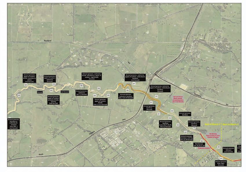
Reach 2 extends from Australind Bypass to east of the South West Hwy (near Burekup). This reach is
approximately 13km long. Private agricultural land abuts the river for the majority of this reach.
DESCRIPTION
FEATURE COMMENTS
Landuse Agricultural land dominates both foreshores. Mainly beef, sheep and dairy industries are
present, with one Winery and Orchard near Burekup.
Land Tenure Lots 6213, 6211 and 31 are vested with the Shire of Harvey or a State Government body.
The rest of the lots in the reach are privately owned.
Fencing Lots 212, 333, 3315, 246, 314, 31, 7,8, 9, 10, 1,44 , 25, 26, 27, 28, 29, 30, 31, 2, 33,and 34
are fenced. However, in some cases cattle crash graze these areas. The remaining lots are
either unfenced or fenced inadequately. For the majority of this reach cattle have access to
the river banks.
CONDITION
FEATURE COMMENTS
Reach 2
Vegetation The foreshore in this reach supports an overstorey consisting of flooded gum (Eucalyptus
rudis), swamp sheoak (Casuarina obesa), peppermint (Agonis flexuosa)and swamp
paperbark (Melaleuca rhaphiophylla). Native understorey is extremely sparse, with the
majority of the understorey consisting of weeds. Rushes and Sedges are rare within this
reach.
Weeds Apple of sodum, blue lupin, watsonia, blackberry, bamboo and bridle creeper are of main
concern in this reach. Apple of sodum is quite common stretching along much of this
reach, where blackberry is only found in specific location. It should be noted that kikuyu
and couch are a problem along this entire reach.
Bank Stability & The majority of this reach is being impacted by some level of erosion. In many sections
Erosion the soil is exposed, mainly due to livestock damage, and embankments are subsiding into
the river. Rushes and sedges are found in very small numbers near Meadow Landings, but
little to none elsewhere in the reach.
Special Features, A community group has formed at Meadow Landings, LCC is assisting the group with
Restoration Sites revegetation and weed control along the developments foreshore.
Please note “encourage” and “support” can mean to; provide financial support, education or
technical advice, depending on the resources available.
page 27 page 28You can also read