AURUKUN WATERWAYS WETLANDS AND COASTAL DRAFT MANAGEMENT - PLAN 2009 (Review Doc)
←
→
Page content transcription
If your browser does not render page correctly, please read the page content below
AURUKUN WATERWAYS WETLANDS
AND COASTAL DRAFT MANAGEMENT
     PLAN 2009 (Review Doc)
Primary Author: Tim O‟Reilly

Editing and report contribution: Louise Adam, Russel Irving, Gina Castelain, Ron
Billiard, NickSmith

Photographs: Tim „Reilly and some provided from Wik Media archives.

Cover Photograph: Big „Ootuk‟ Lake and wetlands, north of Kirke River

This draft report was produced by Wik Projects Ltd on behalf of the Natural Heritage
Trust (NHT). Consultations for this report were conducted by Tim O‟Reilly with members
of the Aurukun Waterways, Wetlands and Coastal Advisory Committee (previously
Aurukun Waterways Steering Committee).

Acknowledgements
This report would not have been compiled without the support from the various
members of the Aurukun community who comprise the Waterways, Wetlands and
Coastal Advisory Committee. Support has also been provided by Aurukun Wetland
Charters and the Aurukun Bauxite Project office. Previous land and sea coordinators
based in Aurukun, as well as key individuals involved with land and sea management
initiatives in Cape York have contributed their first hand knowledge of the area.

Planning work of huge importance has been carried out by various organisations in
Cape York and at the regional level. Much of the supporting information provided in this
draft document was compiled by various natural resource management planning
initiatives funded by the Natural Heritage Trust.

                          ACRONYMS

AWWCAC                         Aurukun Waterways, Wetlands and Coastal
                               Advisory Committee

ASC                            Aurukun Shire Council

CYMAG                          Cape York Marine Advisory Group
CYWFAP                         Cape York Weeds and Feral Animal Project

NAKAC                          Ngan Aak Kunch Aboriginal Corproation

PCB                            Prescribed Body Corporate (PCB)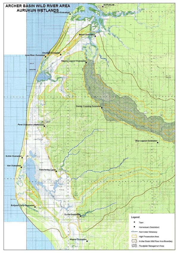
TABLE OF CONTENTS

Executive Summary

1.0 Introduction
1.1 Focus Area
1.2 Aurukun and its people
1.3 Waterways, wetlands and coastal resources
1.4 Land and Sea management status in Aurukun

2.0 Aurukun Waterways, Wetlands and Coastal Advisory Committee
2.1 Terms of Reference
2.2 Summary of Advisory Committee feedback
2.3 Commercial Operators restrictions and Legal Issues
2.4 Wild Rivers legislation

3.0 Key Issues
3.1 Recognised Conservation Values
3.2 Existing infrastructure in a planning context
3.3 Cultural heritage and sites of significance
3.4 Weeds, feral animals and cattle
3.5 Aquatic habitat and water quality
3.6 Commercial fishing
3.6 Recreational fishing, visitor influx and permits
3.7 Access: legal and illegal
3.8 Ghost nets, marine debris
3.9 Riparian and coastal vegetation,
3.10 Erosion, fire management
3.11 Mining, buffer zones and potential dams
3.12 Economic development opportunities
3.13 Traditional fishing and hunting

4.0 High Priority Issues and Recommendations
4.1 Capacity Building
4.2 Resourcing and Development
4.3 Research, Monitoring, patrols, enforcement
4.4 Key Partnerships
4.5 Actions and priority table
4.6 Summary

5.0 References

Appendices
Appendix 1
Appendix 2
EXECUTIVE SUMMARY

Wik Projects was contracted by the Department of Natural Resources and Water to complete
this draft plan on behalf of the Natural Heritage Trust (NHT). Based on a literature review and
consultation work completed in Aurukun, project officer Tim O‟Reilly was appointed to conduct
this work between October 2008 and April 2009.

The two major facets of this project were to reconvene the Aurukun Waterways Steering
Committee (now the Aurukun Waterways, Wetlands and Coastal Advisory Committee) and
to produce a draft Waterways, Wetlands and Coastal Management Plan.

Smaller group meetings were held with the Advisory Committee based on areas of
representation (on country where possible), followed up with group meetings in Aurukun.
Section 2 deals with outcomes and initiatives of the Advisory Committee

Issues concerning the Advisory Committee were identified and discussed, while other important
points for discussion were highlighted by the literature review. Some of the content and pictures
included in this report were compiled during river and coastal field visits over a six month period.

This aim of this draft document is to identify the key issues effecting Wik, Wik Way and Kuugu
people in relation to their water resources, coastline and rivers. Recommendations provided
throughout should be thought of as a work in progress. Rules, regulations and the times change
quickly in Aurukun, so natural resource management planning must also evolve.

It should be remembered this report focuses on the experiences and aspirations of Wik, Wik
Way and Kuugu people, however the general principles of scientific collaboration that are
outlined should be broadly applicable.
1.0            INTRODUCTION

The intrinsic nature of water is summed up in the way Aboriginal people revere it. Both fresh
and salt water environments are a true source of spiritual wealth, a source of life and of
sustenance. Water is the very thing which maintained life for the people living on the land.

Maintaining healthy waterways, wetlands and coastline are of huge importance to all Australians,
however within the scope area of this project it is the Wik, Wik Way and Kuugu people who will
have their views and aspirations represented in relations to water resources.

The relatively pristine nature of the waterways, wetlands and coastline surrounding Aurukun
means this region will receive greater interest as time goes on. Conservation, land management,
tourism and a strong resource base will ensure Aurukun is not left out of the picture.

Past efforts to control and monitor access and to effectively manage land and sea activities
have invariably failed due to a lack of adequate, sustainable levels of funding and resources.
There has been a failure by external agencies and the local council to build capacity within the
community for land and sea management functions. On top of this, the community of Aurukun
has its own unique characteristics which add to difficulties in planning.

To understand the importance of water resources in the area, they must be considered in a
broader social and cultural context. The waters are linked to all aspects of the local Aboriginal
culture – it is the habitat of their totems, source of food and sustenance and the location of
dreamtime stories and sacred sites.

Human impact on the water resources of this area come predominately from mining, tourism
and commercial fishing. This may certainly change into the future depending on the various
economic and social influences at the time.

Land and sea management must be an amalgamation of both scientific and traditionally based
systems that respect the cultural traditions of the Wik, Wik Waya Kuugu peoples (Smith 2005)

  Wild Horses and egrets at Bullyard wetlands
South of Pera Head

Rainbow and sunlight hit near the Aurukun landing     Red cliffs tumble into the water near Amban

                        Rock formations at low tide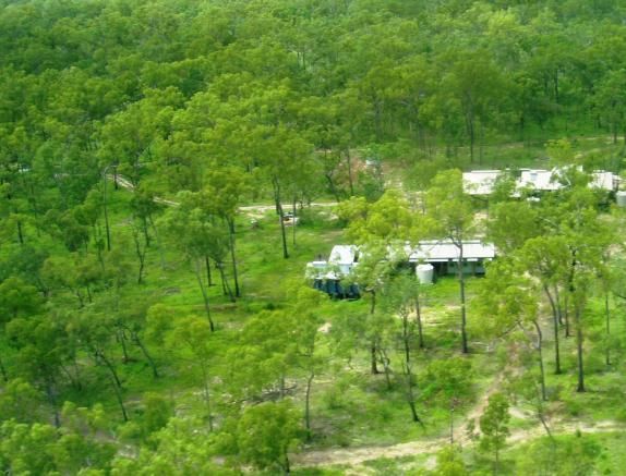
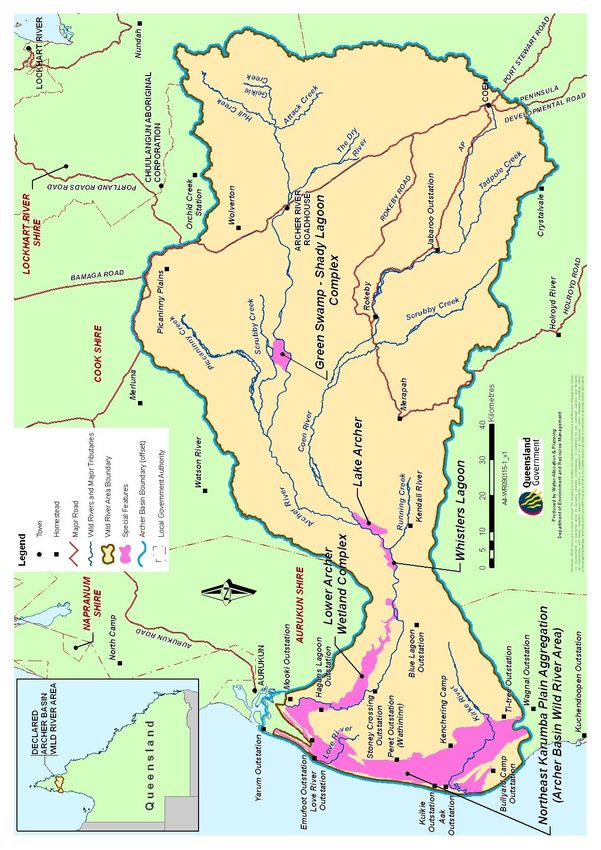
1.1          Focus Area

The territories of Wik, Wik Way and Kuugu people comprise an area of around 280 000km2. On
the west coast of Cape York, this territory extends south from the Embley River as far as the
Holroyd River and east as far as the Strathgordon outstation, to Coen and Myall Ck in the north

The Native Title process has allowed the Wik, Wik Way and Kuugu people to re-gain control
over the majority of their homelands, however more than half of these territories are under
pastoral and or mining lease.

For this planning document to maintain relevance, it must be acknowledged that the State
(rivers, creeks and waterways) and Commonwealth Governments (up to the mean low
watermark) control the coastal and river systems. Clearly a cooperative approach between
government and traditional owners will be required for effective management in all instances.

Figure 1: Map shows location of Aurukun Shire and Wik Native Title Claim in Cape York Peninsula.

Access to the majority of the study area is severely restricted between December and May, with
the main access into Aurukun often closed during this period. A large percentage of the lowland

wetlands country is flooded for extended periods, in some cases, restricting access to people‟s
country in the wetter coastal areas to only 2-3 months of the year.

1.2        Aurukun and its people
Aurukun people have a traditionally close relationship to the water which still binds clan groups
together today. Rivers, water holes and coastline form the boundaries by which families and
clans estates differentiate themselves and linkages to land and sea are still hugely significant.

The Wik, Wik Way and Kuugu people are the traditional owners of the coastal and associated
inland areas from Leithen Point on the Embley River down to the Holroyd River in the south
(see map 1). When Aurukun mission was set up in 1904, it very slowly began to draw in people
from the north and south. People still group themselves through traditional riverine groups
despite the majority of people now living in the community of Aurukun.

Wik people have a long history of defending their traditional lands from the incursions of
Europeans. In the seventeenth century the coastal people played a role in preventing Dutch
explorers from landing at Cape Keerweer. The Cape takes its name from a Dutch word meaning
to „turn back‟, so named because hundreds of armed warriors engaged them in skirmishes that
forced the Dutch to retreat.

The main period of European contact commenced when a Presbyterian mission was
established in 1904 at Archer Bay. This mission had many visitors, mostly Wik people. With the
coming of the missionaries children were confined to dormitories to isolate them from the
influence of their people (ref).

However, many people remained outside the mission up until the 1950‟s and 60‟s, ensuring that
the culture remains strong, even today (Smith 2005). Even in 1949 two thirds of Aurukun‟s
population were still classed as „nomadic‟ in the official census and most of these would have
been from the southern end of the reserve (Sutton 1994)

The Wik people became widely known in Australia in the 1990s through their historic native title
case – The Wik Claim. Following the determination of the Wik native title case1 the land tenure
has been reverted to native title held by the Wik people. The significance of this successful
claim cannot be underestimated. The determination of native title under common law confirmed
the Wik as the original and rightful guardians and managers of their traditional lands.

In the Wik nation there are approximately 50 clan estates clustered intensively along the narrow
coastal flood plain and occupying a very large expanse in the forest and savanna woodland
country of the upland (Sutton, 1978). Each of these clan estates sees the cultural and physical
maintenance of the landscape, waterways and coast as being basic to their survival. (Aurukun
Ref)

A clan is a social category formed on a principle of descent. This was classically, and for the
most part remains, patrilineal descent. That is, a person at birth acquires a primary landed
estate, a set of clan totems, and a set of clan totemic names (differing according to gender)
through her or his father (Sutton 1997).
Clans with estates on the same riverine drainage system are typically significant allies who for a
long time past have closely intermarried and who identify with each other, both in times of
conflict and at other times, by reference to their common river of origin (Sutton 1997).
At the present time the main and active riverine group terms are (Sutton 1997):
„Archer River‟ (subdivided into, „Small Archer‟ and „Main Archer‟, the latter again subdivided
into „Top Archer‟ and „Bottom Archer‟; „Archer Bend‟; „Running Creek‟ area may be referred
to broadly as „Ku‟-aw‟ or, further up, „Meripah‟)
„Love River‟ (subdivided into „Bottom Love‟ and „Top Love‟),
„Cape Keerweer‟ (lower Kirke River system), „Kencherrang‟ (middle Kirke River, an
outstation name), „Oony-aw‟ (upper northern Kirke tributary, a site name), „Ti Tree‟ (upper
eastern Kirke River tributaries),
„Knox River‟,
„Kendall River‟ (subdivided into „Top Kendall‟, „Bottom Kendall‟ and „South Kendall‟, the latter
being the „Holroyd River‟ of official maps),
„Thuuk (Snake) River‟ (the Hersey Creek of official maps),
„Christmas Creek‟ (the Balurga Creek of official maps), and
„Holroyd River‟ (the Christmas Creek of official maps, subdivided into „Top Holroyd‟ and
„Bottom Holroyd‟).
The political and linguistic groups in this area are not clearly defined. The people do own, by
right of clan birth and country, a recognised variety of languages. In the case of the Wik, all of
these languages belong to a simple generic
language family known to linguists as the Wik
group (Sutton 1978). There is around twenty-two
distinct language groups associated with the area,
however despite healthy knowledge of other
languages still existing, Wik Mungkan is the
language formally adopted by Aurukun residents
today.
In the Wik Nation there are various clan groups
from the five major ritual complexes or alliances:
Whinchanam, Wanam, Apalache, Pootche and
Sara. These ritual complexes involve songs,
dances and creation stories that link clan groups in
charge of totemic centres along mythical tracks.
(Sutton, 1978). One senior Wik man explains that
Winchanam is “like university where young people
learn from old people” (Ralph Peinkinna, 2000).
In a planning context, it must be acknowledged that
the majority of Wik, Wik Way and Kuugu people
now live within the township of Aurukun. Others live
Angus Kerindun a Sara dancer
in Napranum, Pormpuraaw and Coen with only
small numbers of people living on outstations with any consistency. This however, does not
diminish the connections people have to their country. Perhaps one of the greatest unrealised
disruptions to the people living in Aurukun is this lack of visitation to homelands. The benefits for
such a trend reversing are too numerous to mention. Not least of all health, education and
cultural maintenance.
Numerous social challenges also face the community of Aurukun, affecting the ability of local
people to engage in land and sea management activities. These include socio-economic drivers
such as passive welfare, poor education levels, substance abuse and the loss of cultural identity
of young people.
Despite these challenges, the people of Aurukun are resilient. Proud people who speak their
native tongue and still fight hard against great adversity for the native title rights they are finally
realizing. Even the casual observer will notice the land and waters remain central to the hearts
and minds of people.
Knowledge transfer is a vitally important feature of effective land and sea management in a
traditional sense. Traditional knowledge is in danger of being lost, so the need to formally
educate young Wik, Wik Way and Kuugu people in such knowledge must become a matter of
urgency (Smith 2005)
1.3 Waterways, wetlands and coastal resources
Wik country covers an area of approximately 280,000 sq. km. These lands run from the coast
through seasonal wetland areas and into extensive tropical savannah areas dominated by
Eucalyptus tetrodonta (Messmate) open-forest communities. The lands, particularly the large
wetland areas, have been accorded high conservation
values by the Australian Heritage Commission
(Abrahams et al, 1995)
Situated around 100km south of the mining town of
Weipa, Aurukun is a community surrounded water. The
wetlands which stretch south from the Archer River are
of monumental proportions with their pristine nature
and relative isolation largely hiding them from public
Aurukun landing attention.
Managing these precious water resources
has emerged as a priority in recent years.
Throughout Australian, too many rivers and
valuable coastal wetlands to mention are
suffering under the weight of dams, poor
water allocation, erosion and a host of other
threats.
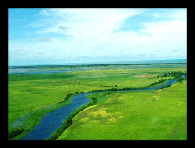
Archer BayMarine plain is located between the Archer River in the north and Kendall River in the south. This marine plain is around 100km in length and varies in width from 2km to 18km, its widest point being at Cape Keeweer. The marine plain is seasonally inundated by king tides and wet season floodwaters. At the height of the wet season, water covers the majority of this plain. Littoral vegetation and habitat surrounding the marine plain grows predominantly on sand ridges. These ancient dunes run in a north south direction the length of the marine plain. Vegetation communities within these sand dunes vary considerably. North of the Archer River E. tetrodonta woodlands in some places grow to the very edge of the coastline and in other places to coastal sand dunes. South of the Archer River E. tetrodonta woodlands grow to the eastern edge of a thin marine plain that runs from the Archer River to the Holroyd River or southern arm of the Kendall River. Besides this marine plain, many timber country wetlands are near permanent and form important dry season refuge for aquatic and terrestrial birds as well as mammals. Table 1: Overview of Landscape Statistics within Aurukun Shire Landscape Statistic Shire 780,000 ha Eucalyptus tetrodonta (Darwin Stringybark) dominated forest 730,000 ha Eucalyptus clarksoniana (Bloodwood) dominated forest 7870 ha Marine plain (seasonally inundated) 9660 ha Woodland, herbland sand dune 3900 ha Mangrove forest 1560 ha Wetland 510 ha Mealeuca viridiflora woodland on depositional plains 7500 ha Melaleuca spp. woodland on seasonally inundated plains 2890 ha Gallery closed forest and Melaleuca spp 10410 ha Closed forests of coastal dunes 260 ha Estuarine lakes (Kirke and Love River lake systems) 3700 ha
Table 2: Limited biological survey work conducted in the area revealed
Species type Number of
species
Birds 173
Snakes 19
Frogs 18
Lizards 16
Arboreal mammals 8
Small ground dwelling mammals 9
Large ground dwelling mammals 3
Microchirpoteran bats 7
Megachiropteran bats 3
Freshwater turtles 2
Sea turtles 4
Crocodile 1
Short beaked echidna 1
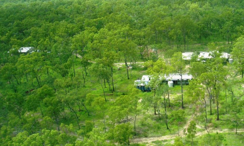
Dolphins play in the waters off Waterfall (Ina Creek)1.4 Land and Sea management, tenure and governance Where not too far in the past, Cape York was divided into cattle stations, Aboriginal communities, tiny towns and not much else, recent changes in law and perception have dramatically changed the equation. Cattle stations have diminished in number, with many in the far north now filling tenure other than pastoral. This has created a patchwork of possible land uses and land tenure is now a very scrambled process, with pastoral lease, mining leases, shire council, national park, Wild Rivers and most importantly the area granted as Native Title coexisting over the territory of Wik, Wik Way and Kuugu people. Aurukun as a community has been through many changes and vast social upheaval has been the norm, rather than the exception. Land and sea initiatives have been stifled and ad hoc. A situation escalated with the wavering support of the Aurukun Shire Council Governance relating to management of the natural and cultural resources of Wik, Wik Way and Kuugu people‟s estates has collapsed. Little or no management is undertaken across land and sea country and Aurukun people are not consulted in relation to those programs which are undertaken. There is a pressing need to establish a new, properly collaborative and consultative management arrangement between Aurukun and a multitude of external parties. For this to occur, it is critically important to have issues of governance clarified over Wik, Wik Way and Kuugu homelands.. Within the Aurukun Shire Boundaries, the Council currently fills the role of land and sea management, determining access, managing infrastructure, administering grants and funding. This is set to change dramatically when functions of land and sea management fall to the “Wik PBC” (Ngan Aak Kunch Aboriginal Corporation) as soon as is practically possible. In the years since the conclusion of the NHT-funded Land and Sea Centre program in 2005, the ASC has failed to demonstrate a commitment to land and sea management. The Shire has failed to secure ongoing support and resourcing for land and sea management, has failed to recruit and support specialist land and sea management staff and neglected to involve traditional owners in decisions relating to the management of their own estates. This lack of input from traditional owners has resulted in land degradation on a large scale, with wildfire continuing to go unmanaged, Parkinsonia spreading unchecked across the Kirke River and Knox River catchments, feral animals continuing to degrade Wik people‟s country, and fish stocks continuing to be decimated by the actions of professional fishers and illegal entrants. Adding to this has been a total collapse of management and maintenance of essential plant and infrastructure across the Shire, including outstations, roads, vehicles, boats and barge transportation. This includes the assets and infrastructure at Wathiniin and Blue Lagoon. A very modern, functional facility exists in the Blue Lagoon Land and Sea Management Centre, located adjacent to upstream reaches of the Archer River. Due to a range of circumstances, this facility sits dormant with zero key outstation and management functions being filled. Not even
barge transportation to ferry vehicles across the Archer River is functioning, effectively
prohibiting any management and enforcement activities occurring over the vast Aurukun
wetlands.

The Blue Lagoon Land and Sea Management Centre has its lease up for tender by the Shire
Council at the time of writing. There have been expressions of interest with a predominately
tourism-driven focus.

Aurukun Shire Council has been unresponsive to partnerships, private enterprise and the
engagement of specialists to help with land and sea management activities. The failure of ASC
to follow up offers of staff and operating budgets from the EPA and DNRM following the
Negotiation Table held in June 2005, or to maintain and resource a Land and Sea Centre are
indicative of the lack of capacity within the ASC to manage land and sea functions.

It is hoped land and sea management of the extensive Wik homelands will be more progressive
and inclusive under the Ngan Aak Kunch Aboriginal Corporation.

Wik and Wik Way country north of the Archer River is located on bauxite-rich land. In 1975,
despite the protests of the Wik people in the community of Aurukun, the Queensland
Government passed legislation authorising mining on the Wik estate2. The Shire was also
placed under the direct control of the State Government in that year. In 1978 the Shire was
granted a 50-year lease on the land. Although nominally under the control of an elected
Aboriginal Council, the land remains under the administration of the Shire clerk and other State-
appointed staff.

There are three parcels of land comprising the Aurukun Shire Council boundaries, with their
extremities bordering the coastline stopping at the mean-high water mark. The State
Government has authority over rivers, creeks and waterways and the Commonwealth
Government controls Gulf waters up to the mean low watermark.

When the area constituting the Wik Native Title Claim is fully settled, the land will be handed
over to the Prescribed Body Corporate, currently registered as the Ngan Aak Kunch Aboriginal
Corporation (NAKAC) . This means the responsibility for land and sea management over Wik,
Wik Way and Kuugu homelands will be transferred to a new entity. Effectively reducing such
functions currently performed by the Shire Council to the areas encompassing the Aurukun
township/

The Ngan Aak Kunch Aboriginal Corporation (NAKAC) holds Native Title to those areas of Wik
and Wik Way peoples estates currently determined. NAKAC has the broad support of Wik Wik
Way and Kuugu people to hold Native Title and deal with Native Title matters. This means the
responsibility for land and sea management over Wik, Wik Way and Kuugu homelands can be
transferred to a new entity. Effectively reducing such functions currently performed by the Shire
Council to the areas encompassing the Aurukun township.
Utilising human resources within Aurukun, matched up to key government, scientific and
philanthropic partners is the key to successful management of Aurukun‟s wetlands, waterways
and coastline. Partnerships which help foster constructive, working outcomes between the
community and external agencies.

What is becoming clear through the many disruptions of tenure resolution is that the
conservation and management of the areas vast and pristine natural features is becoming ever-
more important. It will continue to do so as Queensland and Australia‟s natural resources are
utilised and areas of pristine wilderness continue to dwindle.

Land and sea management is still highly significant to the Wik, Wik Way and Kuugu peoples
who continue to be reliant on the natural environment for their spiritual and physical well-being
(Aurukun Land and Sea Management 2000).

After the collapse of Aurukun Community Incorporated (ACI) in 1996, the ability of local people
to manage outstations and community businesses was severely diminished. During the period
in which ACI operated the community store, a plane supply service and was responsible for
outstation management, Aurukun people spent much more time on outstations. This coupled
with the Manth Thayan Association which conducted land and sea initiatives on country,
including traditional knowledge recording, biological survey work and vegetation mapping made
for a very different attitude to looking after county than is seen today.

Gary Clark who was the coordinator for Manth Thayan Association, pointed out that at any one
time, there was in excess of 70 people living more or less full time at Kencherang outstation with
others such as Bullyard, Walngal having up to 30 people.

In 1992 the CYPLUS (Cape York Peninsula Land use Strategy) set out principles of ecological
sustainability for Cape York. The proponents of this project took the view that the ownership
and management of the natural resources on Cape York were the responsibility of the state.
Aboriginal people, the actual owners and managers of the land, were simply viewed as
„residents‟ on land for which they held no responsibility or authority (Smith 2005). Put simply,
this approach has led to little or no effective management over areas now controlled under
native title.

 The health and proper management of our land and sea and their natural resources are
 intrinsically linked to our social and spiritual identity.

 Just ask any old person in Aurukun today and they will undoubtedly tell you about how much
 time people used to spend healthy, happy lives, living out on country at outstations.

 The establishment of proper management is critical to future well-being of all Wik, Wik Way
 and Kuugu people. AWWCAC

A need for collaborative management and research has arisen due to the nature of changes
resulting from European colonisation. These issues, principally exotic weeds, feral animals and
commercial land use (e.g. fishing and pasture), had not previously figured in Wik, Wik Way and
Kuugu land management regimes (Smith 2005). Collaborative efforts which encompass
traditional practices as well as utilising western scientific knowledge will produce the most
effective management outcomes.

There has been a general decline in visitation of homelands and outstations by Aurukun people
in recent years. Access to the more remote outstations has become problematical with the lack
of road maintenance and inadequate transportation.

The combined roles of Outstation Coordinator and Land and Sea Coordinator have become little
more than an administrative position within the local Shire Council. Under resourced and faced
with transportation difficulties, this position is in need of review, based on the semi-permanent
lives of Wik, Wik Way and Kuugu people in Aurukun community.

Blue Lagoon Land and Sea Management Centre

Currently there are numerous government funded initiatives occurring simultaneously in
Aurukun, nearly all of which are aimed at ameliorating social and health issues. These issues
cannot be ignored; however addressing them at the expense of on-country natural resource
management will exacerbate socio-economic difficulties within the community.

The lack of any true focus on land and sea management activities has left a gaping hole in the
ability of Aurukun to manage and monitor its pristine areas of wetlands, waterway and coastline.
There is a general lack of acknowledgement from within Aurukun of the potential resourcing
options for land and sea management.

Alternative management options are beginning to emerge, especially with regards to rivers,
wetlands and coastal areas. The recent declaration of the Archer Basin Wild River area by the
Queensland Government and the forecast proposal of the Watson Basin will incorporate new
management principles over a large area of Wik, Wika Way and Kuugu lands.

 Government money will never be reliable, it will come and go (AWWCAC)
Key recommendations
Empower and resource the Wik Native Title body – Ngan Aak Kunch Aboriginal Corproation to
coordinate management of land and sea functions, separate from Aurukun Shire Council. The
NAKAC is grossly underfunded to achieve its current aims, and will require support to develop
land and sea management capacity.
Look at a formal withdrawal of ASC from all land and sea management programs outside the
town of Aurukun and facilitate the Queensland and Australian Governments to work directly with
Wik Wik Way and Kuugu people to develop land and sea management administrative structures,
funding arrangements and management programs which recognise the primary role of
traditional owners in managing their own estates
All infrastructure on current Aurukun Shire lease and associated with land, sea and outstation
management should also be transferred including – outstations, Wathiniin, Blue Lagoon, roads,
airstrips, boats, vehicles, barges, tractors, all plant and equipment.
We do not recognise the jurisdiction of Aurukun Shire Council over the resources
associated with land and sea management, tourism or other activities across our estates
(AWWCAC)
Wik Projects is a not-for –profit company operated through a board of Wik and Wik Way
people. Wik Projects is uniquely placed to provide implementation of land and sea
management programs on behalf of the Ngan Aak Kunch Aboriginal Corporation
Adequate long term resourcing for locally determined programs – get away from the
stop-start approaches of the past
Appointments made to the roles of Outstation Coordinator, Land and Sea Coordinator or
Ranger should only be made where a clear pathway exists for resourcing, economic
development and linkages with non-government organisations.
Issues around land tenure must be addressed, in particular the Native Title
determination and the transfer of land from the Aurukun Shire Council to the
Prescribed Body Corporate (PCB). This will have far-reaching implications for natural
resource management in the area.
Before continuing with tender process for Blue Lagoon Land and Sea Management
Centre, ASC should have a full understanding of transfer of land and infrastructure to the
Prescribed Body Corporate and the obligations which come with this transfer.
Leasing out Blue Lagoon Land and Sea Management Centre should only be attempted
with the support and knowledge of traditional owners. Potential lessees should be given
appropriate review and the facility should at the very least retain some of its original
intent; performing land and sea management functions and providing the means for
traditional owners to access their country. This could still be achieved alongside tourism
enterprise development and scientific monitoring.
Build capacity for incorporated clan groups who can take on land and sea management
responsibility. Possibly operating under the governing Ngan Aak Kunch Aboriginal
Corporation. Building capacity of local residents to fulfil monitoring, management and enforcement
roles should be a priority for both government and non-government organisations
looking to conduct activities in this area.
For truly successful outcomes in Aurukun, the injection of funds, rangers and
coordinators must be linked to economic development and fulfilling working roles on
country.
The Aurukun Bauxite Project retains funding for land and sea management initiatives.
One of the sub-components of the Sustainable Development Plan is environmental
management and maintenance of cultural integrity. This funding may be utilised to
progress management initiatives highlighted in this planning process and allow for the
continuation of the AWWCAC2.0 AURUKUN WATERWAYS, WETLANDS AND COASTAL
ADVISORY COMMITTEE
The management of fresh water and marine resources is an integral part of healthy ecosystems
and this understanding has brought about the Aurukun Waterways, Wetlands and Coastal
Advisory Committee (AWWCAC). Perhaps the primary reason for setting up the Advisory
Committee is to provide culturally appropriate representation for all traditional owner groups
within the Aurukun community as they apply to marine and fresh water resources.
Struggling against inconsistent funding and poor management of our lands and waterways as
well as a lack of consultation and control over their management and use.
Numerous threats face the coastal and fresh water regions surrounding Aurukun including
weeds and feral animals, changing fire regimes, commercial pressures, tenure resolution,
mining and legislative regulation over land. These are issues which did not exist in a traditional
context and there are not clear cultural parameters for dealing with such introductions. It is here
that collaboration with external bodies and western science can play a role in assisting people to
manage and maintain their resources.
Wik, Wik Way and Kuugu people are of the firm conviction that they, with their depth of local
environmental expertise, are the best placed and best qualified people to manage their
resources.
It is hoped this Advisory Committee will guide the appropriate use and management of our
rivers, wetlands and coastal areas. This organization will be governed by representatives of
each clan group (AWWCAC).2.1 AWWCAC Terms of Reference
The primary reason for the instigation of the Aurukun Waterways, Wetlands and Coastal
Advisory Committee is to provide culturally appropriate representation for traditional owner
groups. Refer to Appendix 1 for local representatives.
Advisory Committee Roles
Provide forum for waterways, wetlands, and coastal environment issues
Discuss potential issues arising out of Wild Rivers Legislation. Help formulate
submissions to the Minister for DERM
Provide advice to external interests e.g. Mining companies, government and
representative bodies
Provide feedback to the wider Aurukun community regarding management
To facilitate a strong working relationship with a variety of stakeholders
Provide advice on employment and training opportunities related to river and coastal
areas
Support, facilitate and provide advice for developing businesses
Channel for communicating project initiatives to wider community
Be a decision making bodyResponsibilities
Ensure effective communication between parties with an interest in the aquatic
environment (Council, Police, QDPI&F, DNRW, Aurukun Wetland Charters)
Develop awareness with local people of the responsibilities of other agencies managing
waterways, wetlands and the coastal environment
Oversee activities and projects occurring on key representative areas
Be the channel for all communications to and from external parties
Guide research and new projects - e.g. assessment of marine resources, baseline
studies
Participate in monitoring and enforcement activities – boats, fisheries, water quality -
pre/post-mine operations
Ensure greater participation of local people in all projects
Working with Aurukun Wetland Charters to facilitate management aspirations has been
a focus of the steering committee.
Aurukun Waterways Wetlands and Coastal Advisory Committee Meeting April 20092.2 Summary of Advisory Committee feedback The WIK CASE involved a Federal Court determination which ruled that Native Title could co- exist while the land was subject to a pastoral lease But our struggle for the recognition of our land rights is NOT over • We need to have our traditional rights to waterways, wetlands and coastline recognised • Greater control over access is needed • To participate fully in management activities and economic development Why have land and sea functions not worked in Aurukun? Not based on traditional structure – people speaking for country Based on short-term grant funding from government Funding administered purely by Aurukun Shire Council What are some of our Strengths and Resources? A rich and diverse marine base Internationally significant wetlands Pristine waterways Charter boat operation Huge eco-tourism potential Strong culture Youthful and energetic population Recognised native title Mining agreements Real employment opportunities Blue Lagoon Land and Sea Management Centre “Rangers need to be appointed and located appropriately for each traditional clan area in the Archer and Watson Basins, not just in Aurukun” Gin Castelain, Ward – Embley River
Issue                   Hey      Archer   Ward     Watson   Archer     Love     Kirke     Knox     Kendall/
                        Pt –     Bay      River    River    River &    River    River &   River    Holroyd
                        Warbod                              Wetlands            Wetland            River
                        y Pt

Recreational Fishing    Medium   Medium   Low      Low      Medium     High     Low       Low      Medium

Commercial Fishing      High     High     Medium   Low      High       High     High      Medium   High
with nets

Illegal fishing camps   Medium   Low      Low      Low      Medium     High     High      Low      Medium
along rivers

Tourist access          High     Medium   Low      Low      Medium     High     Low       Low      Medium

Manage local            High     Medium   Medium   Medium   High       High     Medium    Medium   Medium
permits, access and
fishing regulations

Need for river and      High     High     High     High     High       High     High      High     High
coastal patrols by
local rangers

Impacted by Wild        High     Low      High     High     High       High     High      Low      Low
Rivers legislation

Ghost nets and          High     Medium   Low      Low      Low        Medium   Medium    Medium   Medium
marine debris

Need for weed and       High     Medium   Medium   Medium   High       Medium   High      High     High
feral animal
eradication

Turtle and dugong       High     High     High     Low      Low        Low      Medium    Low      Low
populations

Potential impacts on    High     Medium   High     Low      Medium     Low      High      Low      Medium
water quality

Buffer zones and        High     Low      High     High     Medium     Low      Low       Low      Low
dams for mining

Sea Grass               High     High     High     Low      Low        High     High      Low      Low
monitoring

Story place             High     High     High     High     High       High     High      High     High
protection

Concern for             Low      High     High     Low      High       Low      High      High     High
outstation
maintenance

Importance for          High     High     High     High     High       High     Medium    Medium   Medium
traditional hunting
and fishing
Silus Wolmby points out wetland information to Christina Howle
Silus Wolmby poins out wetland information to Christina Howley
from CYMAG
“Government aren’t gonna tell us, you fella
Arthur Pambegan viewing AWWCAC report
look after the rivers and wetlands. Not gonna
happen mate. We have to think for ourselves
and look after these places.” Silus Wolmby
Lindsay Kooarta ready to head out camping
Pastor Ralph Peinkinna gives feedback on AWWCAC report2.3 Commercial operators and Legal Issues Until the land is formally handed over to the Prescribed Body Corporate (NAKAC) decision making by Wik, Wik Way and Kuugu peoples in the remainder of their territories is currently restricted to the area bounded by Aurukun Shire which is 7,800 km2 or 780,000 hectares in area. The Local Government (Aboriginal Lands) Act 1978 (Qld) was the legislative instrument that provided for the creation of the Shire of Aurukun3. Under s 3(1)4, the Council of the Shire of Aurukun5 was granted a 50 year lease6 of the land within the Shire‟s current external boundaries7. Under the terms of the lease, the Council is trustee for the land within the Shire boundaries, excluding Crown Reserves. (Ref) As of 9 June 2005, the Council resolved to implement Local Law No. 6 which facilitates the restriction of access to persons outside the community. At present, the Council requested that the Minister for Local Government undertake a State interest test on Local Law No. 6. If the Minister for Local Government is of the opinion that the local law will not fall foul of any state interests, the final step for the Council will be to formally adopt the local law. If the Council were to lawfully enact Local Law No. 6 (Control of Entry) 2005, that local law would successfully control the entry of recreational fishers and other charter boat operator into the Shire‟s waters. For all the rivers, bays and gulfs that form part of the Shire‟s external boundaries, the land included in the Shire area is limited to that of the high water mark. According to the common law, the Shire does not include the beds and banks of waters forming part of its external boundaries to the extent that they are situated lower than the high water mark. This is codified in s 21(1) of the Water Act 2000 (Qld), which provides that the “the bed and banks of all watercourses and lakes forming all or part of the boundary of land are, and always have Makeshift wharf constructed without permission, Love been, the property of the State”.8 (Ref) River Research Papers looking into issues of river closures and restrictions to access were conducted by Caroline Joo (UNSW) and Shannon Torrens (USyd) in 2004. In summary, the Aurukun community believes that it should have the first priority to control and manage its natural resources under the grounds of cultural and environmental preservation and economic development and self-sufficiency.
It is possible to present arguments that closure of rivers to commercial fishing can benefit all
three sectors of the fishing industry: commercial, indigenous and recreational. The arguments in
favour of river closure include those based on Indigenous self-determination and economic
development; Indigenous „rights to commerciality‟; and socio-economic and environmental
benefit.

Lobbying government to close rivers to commercial fishing, buy back licenses and promote an
indigenous „right to commerciality‟ were the preferred options outlined in these papers. This
could be achieved by seeking avenues under the Fisheries Act 1994. Adding to the argument
for the right to commerciality is the existence of an expanding community owned charter boat
operation. The ability of this and other tourism related ventures to exist within Aurukun‟s
waterways, wetlands and coastal areas will be directly affected by the existence of commercial
fisherman and other tourism operators in the area.

At present, monitoring of both commercial and recreational fishing in the area is neither effective
nor comprehensive enough. In the instance that the Aurukun community is unable to close the
waters to commercial fishing, the Department of Fisheries should increase the levels of
monitoring and enforcement in the area. Doing so would reduce the instances of illegal fishing,
overfishing and pollution of the waterways.

Avenues under the Fisheries Act 1994 (Qld)
The Minister for Fisheries can enact a Fisheries Management Plan under the Fisheries Act 1994
(Qld) to either
    1. Close the waters to commercial fishing (operating within the Gulf Of Carpentaria Finfish
        Fishery)
    2. Close parts of the rivers so as to make commercial fishing in the area unviable or;
    3. Revoke the licences of the commercial licence holders.

Fisheries Management Plan (FMP)

The entitle the repository of the power to make a Fisheries Management Plan9 under which
waters may be declared to be closed waters10 where the taking or possessing of fish11,
engaging in specified activities12 and/or using or possessing a boat, acquaculture furniture,
fishing apparatus or anything else13 may be regulated. It also permits the repository of the
power to issue commercial fishing licenses14 or authorities15 that can regulate the permitted
range of species, areas and fishing.

An argument can be made to have the rivers and their tributaries declared Wild Rivers closed to
commercial fishing on numerous grounds. HOWEVER the Beattie government has pledged that
in spite of the Wild Rivers Act (Qld), it “would honor existing agreements, permits, lease
conditions and undertakings”16, meaning that existing commercial licenses to fish in
designated wild rivers would remain unaffected.
Although Sate Government regulations ensure commercial fishing license holders can still
function within rivers unless closures occur the Aurukun Shire Council currently holds the power
to prevent non-community sanctioned commercial and charter operations anywhere inside the
mouths of the Embley, Hey, Norman Ck, Archer, Love, Kirk, Kendall / Holroyd Rivers.
The Aurukun Waterways Wetlands and Coastal Advisory Committee would like to create a
Fisheries Management Plan with the assistance of the DPI &F. It is envisioned this
Management Plan would provide a framework for current and future rivers closed to commercial
fishing and access controlled by the Ngan Aak Kunch Aboriginal Corporation.
The State Government may look at license buy backs for commercial licenses fishing
the Archer (2), Love (1), Kirke (1) and Kendall Rivers (1) in recognition of the
commercial arrangements and potential for personal hardship faced by commercial
fishers across rivers affected by potential closures. This is supported by the AWWCAC
In the Northern Territory, research has shown that the catch per unit effort of the commercial
barramundi sector outside the rivers that have been closed to commercial fishing (the Daly,
Mary and Roper Rivers) has increased. It showed that once the gill nets were removed from the
river systems, the barramundi and other species were able to build in numbers and increase the
stocks of fish in other waters as the fish naturally move throughout the rivers (Joo & Torrens
2004).
If the Embley, Hey and Watson Rivers have been closed to commercial fishing for the reason of
giving mine workers and local residents a viable recreational fishery into the future, then closure
to rivers further south (e.g. Archer, Love and Kirke Rivers) should result from mining
development encroaching on these rivers also.
Mission River, Embley River and Hey River
s 3 om 2008 SL No. 84 s 81
Watson River (designated closed in 1989)
s 4 om 2008 SL No. 84 s 81
Kirke River
s 4A ins 2003 SL No. 215 s 26
om 2008 SL No. 84 s 81
Research has indicated the importance of controlling the use of resources and access to rivers
within the Aurukun Shire. The Aurukun community‟s “commerciality” argument means Aurukun
people can regain management rights and responsibilities that can be exercised withoutincreasing the environmental or resources burden17. This is in accordance with the principle that the need to develop a strong, growing and diversified economy must enhance the capacity for environmental protection (Adams 2005). The Queensland government has an official policy document entitled the Fisheries Resource Allocation Policy and it is suggested that a proposal can be made to the State government to have the waters closed to commercial fishing and other users of the waters. It also recognises the special needs of indigenous related economic development opportunities. Given that alcohol restrictions apply to the Kendall River, Archer River, Watson River and the upper reaches of the Hey River18 to the extent that lie within the Shire‟s external boundaries, there is a strong argument that if these waters are part of the Shire for the purposes of the Liquor Act 1992, the waters are part of the Shire for all purposes, including the Council‟s right to control entry into the Shire.(Ref). This has not been tested as a means of restricting commercial operations in Shire waters. Professional fisherman's camp at Love River after Professional fisherman‟s camp on the banks of the season closure (Dec 2008) Kirk River
2.4 Wild Rivers legislation
The Queensland Government gazetted the Lockhart, Stewart and Archer Basins on Cape York
under its Wild Rivers legislation on April 3, 2009.
The declared Archer Basin Wild River Area covers an area of approximately 13756km2 (see
Map 2). The area encompasses the catchments of the Archer River, Love River and Kirke
Rivers. Advice suggests the Watson River Basin will be proposed at some stage in 2009.
The nine major tributaries identified are the Dry River (tributary of the Archer River), Geikie
Creek (tributary of the Archer River), Hull Creek (tributary of Geikie Creek), Piccaninny Creek
(tributary of the Archer River), Scrubby Creek (tributary of Piccaninny Creek), the Coen River
(tributary of the Archer River), Tadpole Creek (tributary of the Coen River), Scrubby Creek
(tributary of the Coen River) and Running Creek (tributary of the Coen River).
Special features include off-stream features that have significant hydrological connections to the
wild rivers, major tributaries or nominated waterways. On-stream features that are connected to
or form part of the wild rivers and major tributaries may also be designated as special features.
The special features identified in the proposed wild river area are:
Green Swamp
Shady Lagoon Complex
Lake Archer
Whistlers Lagoon
Lower Archer Wetland Complex
Love River Estuarine Complex
Kirke River Estuarine Complex
The proposed wild river area has near-natural; water flow, sediment deposition and erosion
processes. These processes maintain a diverse range of freshwater and estuarine habitats,
supporting relatively undisturbed ecosystems along the waterways and in the proposed wild
river area.
Water quality in the majority of rivers in the proposed wild river area is near natural, due to the
minimal release of pollutants and the relatively unaltered sediment movement. This is supported
through fish studies and the condition of the basin estuaries.
Riparian function and wildlife corridors are relatively intact in the proposed wild river area, due to
free flowing rivers and continuous, dense native vegetation along streams and across the area.
This helps to preserve stable
watercourse beds and banks
and maintain healthy aquatic
and terrestrial habitats, many
of which are important refuges
during the dry season and
times of flood.
The proposed floodplain
management area
encompasses areas prone to
Stunning lagoons in the upper reaches of Watson Riverflooding along the Archer River, Piccaninny Creek, Scrubby Creek and the Coen River. It
extends over 160 km upstream from near the mouth of the Archer River. Abundant waterholes
and lagoons occur along many of these channels which are dependent on flood events for
replenishment. Extensive flooding is a feature of the Archer River system due to its relatively
low relief and the periodically high rainfall which results in high flows.
Summary of important points and issues affecting Aurukun
“Traditional Activities: A Wild River Declaration will not regulate of restrict traditional
Indigenous activities such as camping, fishing, hunting or conducting traditional
ceremonies and fire management practices. Similarly, the declaration will not effect
gathering plant materials and plant products, ochre and timber for traditional activities”
Native title and cultural heritage: A Wild River Declaration does not limit a person‟s rights
to the exercise or enjoyment of Native Title. Neither does it affect the Native Title
process.
A Wild River declaration does not affect the cultural heritage in a Wild River area, or the
functioning and operation of the Aboriginal Cultural Heritage Act.
Outstations and other buildings including houses, cottages and cheds, can be erected in
a wild river area. They will only be subject to the Wild Rivers Code if a development
permit is required by the local council.
Aquaculture not deemed to be an environmentally relevant activity within the High
Preservation area will not be approved. Effectively blocking off aquaculture within 1km of
all major rivers and tributaries in the Archer Basin.
Leading up to the Archer Basin declaration, traditional owners were unclear what decision
making authority they might have and what level of consultation and participation they will have
during and after Wild River Declarations.
We consider ourselves full custodians and owners of the land and waterways within the Archer
and Watson River basins with full rights as conferred under Native Title
The AWWCAC would like to highlight the inconsistency that seems to allow existing commercial
fishing operators to operate and derive economic benefit from these same areas. How can the
continuation of these, short term, licence based operations be recognized and allowed but not
the permanent, native title based rights of traditional owners. (AWWCAC)
Wild Rivers legislation creates a number of opportunities for Wik and Wik Way people to protect
their natural and cultural heritage whist benefiting from land management incentives.
However it does not address issues around the commercial exploitation of fisheries resources.
“If these new rules which come to the people of Aurukun in black and white, means that it’s
harder for us to make a living from our rivers, then these same rules must make sure
commercial fisherman do the right thing by our rivers.” Richard OrnyengaiaThe Wild Rivers Bill argues, “the ecological cycles of a river system replenish natural and
cultural values. Reducing the health and environmental values of a river system erodes cultural
values and can result in the loss of connection to country and the natural world. This in turn
undermines the basis of Indigenous connection to traditional lands and the transmission of
ecological and cultural knowledge through the generations.”
Aurukun Uniting Church, which welcomed the legislation but was wary of an exemption for the
Aurukun Bauxite Project, has also weighed into the debate over Wild Rivers Legislation.
The Elders submit to the Minister that for the Wild Rivers Legislation to be effective in protecting
the pristine Archer River and Basin in the face of an unprecedented threat from mining then the
mining project must come under the full power of the intent and purpose of the legislation with
no exemptions or concessions (ABC News online).
Key recommendations
In recognition of the significant cultural and environmental values of the Archer and
Watson River Basins, the AWWCAC strongly recommend appointing Wild Rivers
resources to Aurukun in a culturally appropriate manner.
A Watson Basin Wild Rivers proposal should incorporate cultural heritage as well as
ecological information summaries. Cultural heritage information can be supplied by Wik
Projects Ltd which is registered as Cultural Heritage body. The Archer Basin proposal
did not incorporate this much needed information.
While management strategy is being formulated for Archer Basin, support proposal for
Archer Basin Wild Rivers Consortium (traditional owners, Aurukun, Coen, pastoralists)
and Wild Rivers Coordinator based in Cape York, not Cairns. To begin with, working
between Aurukun, Coen and Lockhart River and then appointing independent
coordinator to each basin.
Any Wild Rivers resources based in Aurukun will need dual roles for effective outcomes.
The same people representing Wild Rivers for their customary waterway, can also be
completing river and coastal patrols, ghost net and tourism guiding roles.
“If they are calling this a wild river area, then they should do something about those
pigs. Even turtles nesting all along the beach, right down to Holroyd River, getting
their nests dug up by those pigs.” Joel Ngallametta
“Rangers should be out there, protecting that place” Clarence Peinkinna, Love River
Instigate a 12 month trial, housing a Wild Rivers ranger with Aurukun Wetland Charters
to fill roles outlined above.
Traditional Owners strongly believe that Wild River Rangers need to be appointed to
support each clan group area to effectively manage and monitor these areas. It is not
culturally appropriate or logistically feasible for effective monitoring and control to simply
base 1 or 2 rangers in Aurukun with responsibility for the whole Archer Basin
Provide ongoing re-current funding to ensure Wild Rivers Ranger representation for all
Traditional Owner clan groups in the Archer and Watson Basins. It must also be clear
that this involves Love and Kirke River traditional owners.
The advent of the community operated charter boat business (Aurukun Wetland
Charters) provides an avenue for employing Wild Rivers resources and utilising the skillsand knowledge of traditional owners to effective manage and monitor waterways. It also
addresses the issue of access to country with vehicle and boat usage a feasible option.
Wild Rivers rangers should be linked to specific waterways in line with traditional rules of
custodianship. “We cannot have someone from Archer River doing ranger activities in
the Love River without a Love River person there.” (Cecil Walomby)
Having access south of the Archer River is essential to effective Wild Rivers
management. Utilising
Blue Lagoon Land and
Sea Management Centre
as a dry season base for
monitoring, research and
tourism may prove
beneficial for the Aurukun
Shire Council, tourism
operators and external
organisations looking for
access into this remote
and pristine wilderness.
The committee would like
to ensure that a process Melaleauca swamp inland of Merkunga Creek (Watson River)
is in place for the Archer
Basin declared area that provides all impacted traditional owner groups with decision
making authority for matters impacting on their waterways.
Full participation and consultation regarding decisions made under the Wild Rivers
legislation is a basic requirement of the AWWCAC.
There are typically poor levels of literacy and numeracy within the cross section of
people living in Coen, Aurukun and Pormparaaw. Indigenous people are far less likely to
apply for development approvals in these areas than other Australians and foreign
investors. Resources should be made available to assist with development applications,
water allocations and a multitude of requirements set out in Wild Rivers Legislation.
Ensure Wild Rivers rangers are given appropriate levels of authority to report and
monitor illegal fishing activity.
“Rangers need to be appointed and located appropriately for each traditional clan area
in the Archer Basin, not just in Aurukun”
(Gina Castelain: Wik Waya)
High Preservation Area (special features & 1km either side of rivers and
major tributaries)
Activities potentially allowed in HPA
- tourism such as fishing charters, tours, facilities such as accommodation and
camping grounds
- outstations
- residential and commercial developmentsYou can also read