Environmental Assessment Report and Operations Plan - Lot 6767 & 561 Howell Road, Marbelup WA 6330
←
→
Page content transcription
If your browser does not render page correctly, please read the page content below

Lot 6767 & 561 Howell
                           Road, Marbelup WA
                                  6330

Environmental Assessment Report and
          Operations Plan

                          Bio Diverse Solutions
                          Final v. 1
                          18/02/2021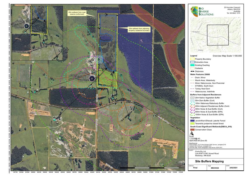
Environmental Assessment Report and Operations Plan Lots 6767 & 561 Howell Road

DOCUMENT CONTROL

TITLE
Lot 6767 & 561 Howell Road, Marbelup Environmental Assessment Report and Operations Plan
Author (s): Kathryn Kinnear and Bianca Theyer
Reviewer (s): Kathryn Kinnear, Chiquita Cramer and Stephen Slack
Job No.: MSC0324
Client: Cosla Pty Ltd.

REVISION RECORD

 Revision         Summary                                             Prepared By            Reviewed By             Date
 Draft v. 1       Internal QA review                                  B. Theyer              C. Cramer               2/02/2021
 Draft v. 2       Internal QA review                                  B. Theyer              K. Kinnear              5/02/2021
 Draft v. 3       Submitted to client for review                      B. Theyer              S. Slack                5/02/2021
                  Updated as per client review and submitted to
 Final v. 1       client as final                                     B. Theyer              K. Kinnear              18/02/2021

 Bio Diverse Solutions Australia Pty Ltd
 Albany Office                              Denmark Office                              Esperance Office
 29 Hercules Crescent                       Unit 7, 40 South Coast Highway              Unit 2A, 113 Dempster Street
 Albany WA 6330                             Denmark WA 6333                             Esperance WA 6450
 08 9842 1575                               98481309
 www.biodiversesolutions.com.au
 ABN 46 643 954 929
 (C) Copyright: This document has been prepared by Bio Diverse Solutions for use by the client only, in accordance with the terms
 of engagement, and only for the purpose for which it was prepared.

MSC0324                                                 18 February 2021                                                         i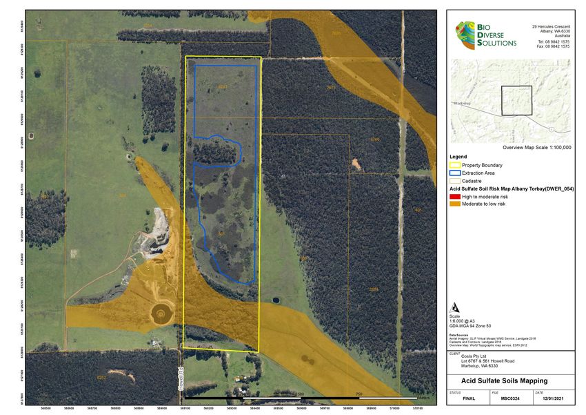
Environmental Assessment Report and Operations Plan Lots 6767 & 561 Howell Road

                                                                                       CONTENTS
1.       INTRODUCTION .......................................................................................................................................................................1
1.1.     ALIGNMENT TO LEGISLATION, POLICY AND GUIDELINES ................................................................................................1
2.       BACKGROUND ........................................................................................................................................................................2
2.1.     SITE DETAILS ..........................................................................................................................................................................2
2.2.     EXISTING LAND USES ............................................................................................................................................................2
2.3.     ADJACENT LAND USES AND TENURE .................................................................................................................................3
3.       DESKTOP ASSESSMENT .......................................................................................................................................................3
3.1.     CLIMATE ...................................................................................................................................................................................3
3.2.     TOPOGRAPHY .........................................................................................................................................................................3
3.3.     GEOLOGY AND SOILS ............................................................................................................................................................3
3.4.     WATER .....................................................................................................................................................................................3
3.5.     ACID SULFATE SOILS .............................................................................................................................................................4
3.6.     REMNANT VEGETATION ........................................................................................................................................................4
3.7.     ABORIGINAL HERITAGE .........................................................................................................................................................5
4.       SITE ASSESSMENT .................................................................................................................................................................6
4.1.     VEGETATION TYPES ..............................................................................................................................................................6
5.       PROPOSED DEVELOPMENT ................................................................................................................................................10
5.1.     EXTRACTION PROCESS, STAGING AND HAULAGE ROUTES .........................................................................................10
5.2.     VEGETATION AND TOPSOIL REMOVAL .............................................................................................................................10
5.3.     OPERATION TIMES ...............................................................................................................................................................10
5.4.     VEHICLES AND MACHINERY ...............................................................................................................................................10
6.       ENVIRONMENTAL CONSIDERATIONS ................................................................................................................................11
6.1.     NOISE .....................................................................................................................................................................................11
6.2.     DUST AND EROSION ............................................................................................................................................................12
6.3.     LIGHT......................................................................................................................................................................................12
6.4.     DISCHARGES TO LAND ........................................................................................................................................................12
6.5.     WETLANDS ............................................................................................................................................................................13
6.6.     DISCHARGES TO WATER ....................................................................................................................................................13
6.7.     FLORA AND VEGETATION ...................................................................................................................................................13
6.8.     FAUNA ....................................................................................................................................................................................13
7.       MANAGEMENT PLANS ..........................................................................................................................................................14
7.1.     DUST MANAGEMENT ............................................................................................................................................................14
7.2.     NOISE MANAGEMENT ..........................................................................................................................................................15
7.3.     TRUCK MOVEMENTS ............................................................................................................................................................16
7.4.     STORMWATER MANAGEMENT ...........................................................................................................................................16
7.5.     WEED MANAGEMENT ...........................................................................................................................................................16
7.5.1.   AIMS OF WEED MANAGEMENT PLAN ................................................................................................................................17
7.5.2.   PROGRAM FOR WEED CONTROL .......................................................................................................................................17
7.6.     DIEBACK AND GENERAL HYGIENE MANAGEMENT ..........................................................................................................19
7.7.     BUSHFIRE RISKS AND MANAGEMENT ...............................................................................................................................19
7.8.     REHABILITATION MANAGEMENT ........................................................................................................................................21
7.9.     CONTROL OF ENVIRONMENTAL INCIDENTS ....................................................................................................................22
7.10.    CORRECTIVE AND PREVENTATIVE ACTIONS ...................................................................................................................23
7.11.    CONTINGENCY PROCEDURES ...........................................................................................................................................23
7.12.    SPILL MANAGEMENT PROCEDURES .................................................................................................................................23
7.13.    MONITORING AND CONTINGENCY PLANNING .................................................................................................................25
8.       CONSULTATION PROCESS .................................................................................................................................................26
9.       IMPLEMENTATION PROCESS ..............................................................................................................................................27
10.      REFERENCES ........................................................................................................................................................................28
11.      APPENDICES .........................................................................................................................................................................30

MSC0324                                                                            18 February 2021                                                                                           ii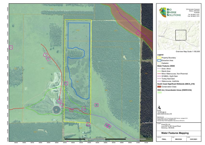
Environmental Assessment Report and Operations Plan Lots 6767 & 561 Howell Road

LIST OF TABLES
Table 1: Condition Rating Scale
Table 2: Generalised Weed Management Program for Common Species
Table 3: Bushfire protection criteria applicable to the site
Table 4: Vehicular Access Technical Requirements (WAPC, 2017)
Table 5: Environmental Monitoring Activities During Construction
Table 6: Implementation Program

LIST OF FIGURES
Figure 1: Property Locality
Figure 2: Photographs of the Grassland vegetation type and some images of paddock trees in poor / deteriorating health.
Figure 3: Photographs of Eucalyptus staerii tree with evidence of arboreal mammal utilisation.
Figure 4: Photographs of the Taxandria juniperina closed forest vegetation type.
Figure 5: Photographs of the Jarrah/Marri/Sheaok Laterite Forest vegetation type.
Figure 6: State Bushfire Prone Mapping (OBRM, 2019).
Figure 7: Private driveway design requirements (WAPC, 2017)

LIST OF APPENDICES
Appendix A –Site Facility Mapping
Appendix B – Water Features Mapping
Appendix C – Vegetation Mapping
Appendix D – Bushfire Mapping
Appendix E – Main Roads WA Correspondence
Appendix F – Database Searches

MSC0324                                                  18 February 2021                                                     iii
Environmental Assessment Report and Operations Plan Lots 6767 & 561 Howell Road

1. Introduction
Bio Diverse Solutions (Environmental Consultants) was commissioned by Cosla Pty Ltd (“The Client”) as environmental consultants
to prepare an Environmental Assessment Report and Extraction Operations Plan for the proposed extraction project at Lots 6767 and
561 Howell Road, Marbelup within the City of Albany. The purpose of this document is to assess the environmental values for the site,
assess the proposed facility and provide supporting documentation for a Development Application with the City of Albany. The
document provides and outlines details of emissions associated with the project and proposed mitigation measures.

   1.1. Alignment to Legislation, Policy and Guidelines
In assessing the proposed gravel extraction facility, Bio Diverse Solutions has prepared this report aligned to the following legislation:

   •     Biosecurity and Agriculture Management Act 2007 (BAM Act);
   •     Environmental Protection Act 1986;
   •     Environmental and Protection and Biodiversity Conservation Act 1999 (EPBC Act);
   •     Environmental Protection Authority (EPA) (2005) Separation Distances between Industrial and Sensitive Land Uses –
         Guidance Statement No. 3 (current and endorsed guideline);
   •     Due regard to the Draft Separation Distances between Industrial and Sensitive Land Uses (2015);
   •     Environmental Weeds Strategy for Western Australia 1999;
   •     Wildlife Conservation Act 1950;
   •     Biodiversity and Conservation Act 2016;
   •     Conservation and Land Management Act 1980 (CALM Act);
   •     Environmental Code of Practise – Extractive Industries (1990) – DEP (now EPA);
   •     Water Quality Protection Note No.25 (2016), Land use compatibility tables for public drinking water source areas – DoW (now
         DWER);
   •     Water Quality Protection Note No.15 (2019) Basic raw materials extraction –DWER; and
   •     City of Albany Policy Extractive Industries and Mining.
The preparation of this plan is to guide extraction activities by Cosla Pty Ltd as per the City of Albany Policy: Extractive Industries and
Mining. Licensing of extraction is the delegated authority of the local government. Any operations which are subject to regulation under
the Environmental Protection Act (1986) (EP Act) are delegated to the Department of Water regulation and compliance to administered
licensing under the Environmental Protection Regulations (1987). Interpretation of the regulations is defined through guidelines. The
current and endorsed guideline pertaining to sensitive land uses and setback requirements is the Environmental Protection Authority
(EPA) (2005) Separation Distances between Industrial and Sensitive Land Uses – Guidance Statement No. 3.
The activity of crushing and screening is only examined in this document as a component of the noise management plan. Buffers,
setbacks and licensing conditions are to be dealt with by DWER as part of a works approval application by the proponent.

MSC0324                                                     18 February 2021                                                         1
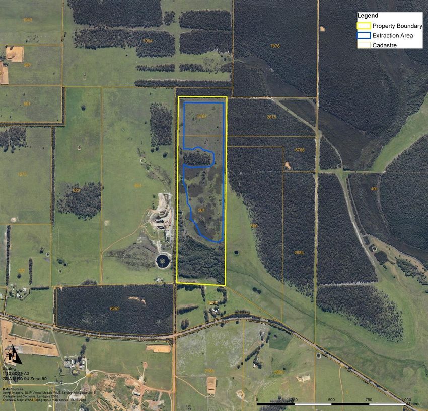
Environmental Assessment Report and Operations Plan Lots 6767 & 561 Howell Road

2. Background
   2.1. Site Details
The “property” is defined as Lots 6767 and 561 Howell Road and is located 15km northwest of the Albany CBD. The combined area
of the two lots is 40.915 hectares and is zoned as “General Agriculture” under the City of Albany Local Planning Scheme No. 1. The
“extraction area” is defined as the 19.9ha area in which extraction will occur with five stages. There are multiple pits within each stage.
The “crushing and screening extents” are defined as the area in which crushing and screening operations will occur. Please refer to
Figure 1 below and Appendix A - Site Facility Mapping.

Figure 1: Property Locality
   2.2. Existing Land Uses
Currently the property is being utilised for cattle grazing / general agriculture and there are no residential dwellings located within the
property. The adjacent surrounding properties are also zoned as “General Agriculture”. After extraction activities are complete the
property will return to agricultural grazing pursuits. The remnant bushland vegetation in the northern and southern parts of the property
will not be cleared as part of this project.

MSC0324                                                     18 February 2021                                                         2
Environmental Assessment Report and Operations Plan Lots 6767 & 561 Howell Road

   2.3. Adjacent Land uses and Tenure
The subject site is located within an agricultural area, with residential agricultural properties immediately to the west, and south, and
further to the north and east. There is an existing sand extraction project in the adjacent property to the west and existing gravel
extraction projects to the south of South Coast Highway. The Down Road Nature Reserve (R20948) is located to the north of the
property and Nature Reserve (R24661) to the south west of the property. The Marbellup Nature Reserve (R24891) is located to the
south west of the property. The City of Albany Reserves R33271 and R24000 are located to the south east of the property along Howell
Road South and Reddin Road.

3. Desktop Assessment
Desktop assessment was undertaken of government databases to ascertain environmental aspects both within the property and the
surrounding area. This assessment was conducted to various levels, ranging from state-wide to area specific information and includes
information on climate, geology and soils, environmentally sensitive areas, acid sulfate soils, public drinking water areas, water bodies
and aboriginal heritage. Desktop inventory of potential Threatened and Priority flora and fauna species likely to occur within 10km of
the property was undertaken using the following databases:

     •    10km NatureMap Database Search (combined data from DBCA, WA Museum and WA Herbarium); and
     •    10km Protected matters search tool (DAWE 2020);
Based on results from the above databases there are 38 conservation significant flora species and 69 conservation significant fauna
species (terrestrial species only) potentially present within 10km of the property. The full species list compiled from all available data
(Appendix F) is based on observations from a 10km radius of the study area and is likely to include species that would not occur in the
property due to a lack of suitable habitat. The data also includes very old records and in some cases the species in question may have
become locally or regionally extinct.
The conservation significance of flora and fauna species has been assessed using data from the following sources:

     •    Environment Protection and Biodiversity Conservation Act 1999 (EPBC Act). Administered by the Australian Government
          Department of Agriculture, Water and Environment (DAWE);
     •    Biodiversity Conservation Act 2016 (BC Act). Administered by the Western Australian Department of Biodiversity
          Conservation and Attractions (DBCA); and
     •    DBCA Priority Flora list. A non-legislative list maintained by DBCA for management purposes.

   3.1. Climate
The nearest Bureau of Meteorology (BoM) operational station is Albany (Site No. 009500). The average maximum temperature is
19.5°C whilst the average minimum temperature is 11.8°C. The average annual rainfall for the station is 925.2mm, with the majority
of rainfall occurring between May and September (BoM, 2021).

   3.2. Topography
The property is located in an undulating landscape in the Marbelup area. The property has northern and southern aspects with slopes
ranging from 55m AHD in the north of the site to 25m AHD in the south east of the site. The paddock within the northern portion of the
property is relatively flat with the majority of the area located within the 55m AHD contour line.

   3.3. Geology and Soils
Database searches shows the property lies within the King System (242Kg). The system is described as “Dissected siltstone and
sandstone terrain, on the southern edge of the Albany Sandplain Zone, with shallow gravel, sandy gravel, grey sandy duplex and pale
deep sand. Jarrah-marri-sheoak woodland and mallee-heath.” (DPIRD, 2017a). The property also lies within the Albany Sandplain
Zone, described as having “Gently undulating plain dissected by a number of short rivers flowing south. Eocene marine sediments
overlying Proterozoic granitic and metamorphic rocks. Soils are sandy duplex soils, often alkaline and sodic, with some sands and
gravels.” (DPIRD, 2017b).

   3.4. Water
The property lies within the Denmark Coast Catchment area and the Albany Sandplain Hydrological Zone (HZ20_AS) which is

MSC0324                                                     18 February 2021                                                        3
Environmental Assessment Report and Operations Plan Lots 6767 & 561 Howell Road

describes as “Gently undulating plain dissected by a number of short rivers flowing south. Eocene marine sediments overlying
Proterozoic granitic and metamorphic rocks. Soils are sandy duplex soils, often alkaline and sodic, with some sands and gravels”
(DPIRD, 2017c). There are several minor watercourses within and adjacent to the property.
There is one minor non-perennial water course within the south within the marsh area, this also extends into the adjacent property to
the west. There is a minor drainage watercourse that extends out of the property to the east into the surrounding area. No other wetland
areas were identified as being present within the extraction area during the desktop assessment.
The property is not located within a Public Drinking Water Source Area. It is however, located within the RIWI Act Proclaimed “Albany
Groundwater Area” (DWER 2018a; 2018b). Refer to Appendix B – Water Features Mapping.

   3.5. Acid Sulfate Soils
The Acid Sulfate Soils mapping (DWER, 2017a) shows that there is a moderate to low risk of acid sulfate soils occurring in the southern
portion of the property.

   3.6. Remnant Vegetation
The property lies within the Southern Jarrah Forest JAF02 IBRA subregion. Hearn et al (2002) describes the IBRA region as
“Duricrusted plateau of Yilgarn Craton characterised by Jarrah-Marri forest on laterite gravels and, in the eastern part, by Wandoo -
Marri woodlands on clayey soils. Eluvial and alluvial deposits support Agonis shrublands. In areas of Mesozoic sediments, Jarrah
forests occur in a mosaic with a variety of species-rich shrublands.”
The vegetation has been mapped on a broad scale by J.S. Beard (Shepherd et al. 2002) in the 1970’s, where a system was devised
for state-wide mapping and vegetation classification based on geographic, geological, soil, climate structure, life form and vegetation
characteristics (Sandiford and Barrett, 2010). Vegetation units were regarded as associations and were grouped into Vegetation
Systems representing a particular pattern of association distribution within a given area. A GIS search of J.S. Beards (Beard et al.
2013) vegetation classification places the subject site within two System and Vegetation Association (Source Pre-European dataset,
DPIRD, 2017d):

     •    System Association Name: Albany.
     •    Vegetation Association Number: 978.
     •    Structure Description: Low forest, woodland or low woodland with scattered trees.
     •    Floristic Description: Jarrah, banksia or casuarina Eucalyptus marginata, Banksia spp., Allocasuarina spp.
     •    Remnant Vegetation by Beard Association Rarity in LGA: 35.89% remaining (GoWA, 2019).
     •    Remnant Vegetation by Beard Association Rarity in IBRA Region: 35.37% (GoWA, 2019).

     •    System Association Name: Albany.
     •    Vegetation Association Number: 51.
     •    Structure Description: Sedgeland; reed swamps, occasionally with heath.
     •    Floristic Description: Cyperaceae, Restionaceae, Juncaceae (mainly in the South-West).
     •    Remnant Vegetation by Beard Association Rarity in LGA: 36.01% remaining (GoWA, 2019).
     •    Remnant Vegetation by Beard Association Rarity in IBRA Region: 32.70% remaining (GoWA, 2019).
The surrounding native remnant vegetation (within 1km) has previously been mapped during the Albany Regional Vegetation Survey
(Sandiford and Barrett 2010). The area is quite diverse with nine different units / complexes described. The most prominent vegetation
type is the Jarrah/Marri/Sheoak Laterite Forest. Refer to Appendix C – Native Vegetation Mapping.

     •    Vegetation Name: Jarrah/Marri/Sheoak Laterite Forest
     •    Map Code: 12

     •    Vegetation Name: Jarrah/Sheoak/E. staeri Sandy Woodland
     •    Map Code: 13

     •    Vegetation Name: Banksia coccinea Shrubland/Eucalyptus staeri/Sheoak Open Woodland
     •    Map Code: 14

MSC0324                                                    18 February 2021                                                       4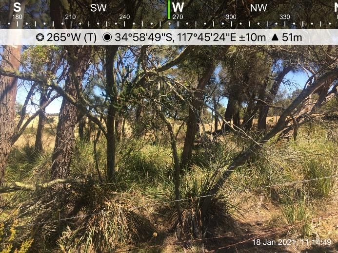
Environmental Assessment Report and Operations Plan Lots 6767 & 561 Howell Road

    •    Vegetation Name: Hakea spp Shrubland/Woodland Complex
    •    Map Code: 31

    •    Vegetation Name: Taxandria parviceps Transitional Shrubland
    •    Map Code: 38

    •    Vegetation Name: Pericalymma spongiocaule Low Heath
    •    Map Code: 39

    •    Vegetation Name: Evandra aristata Sedgeland
    •    Map Code: 46

    •    Vegetation Name: Homalospermum firmum/Callistemon glaucus Peat Thicket
    •    Map Code: 47

    •    Vegetation Name: Taxandria juniperina Closed Forest
    •    Map Code: 59

   3.7. Aboriginal Heritage
Database records show the property lies within the Marbelup Brook (ID29673) which is listed as a mythological, natural feature site
(DPLH 2019).

MSC0324                                                  18 February 2021                                                     5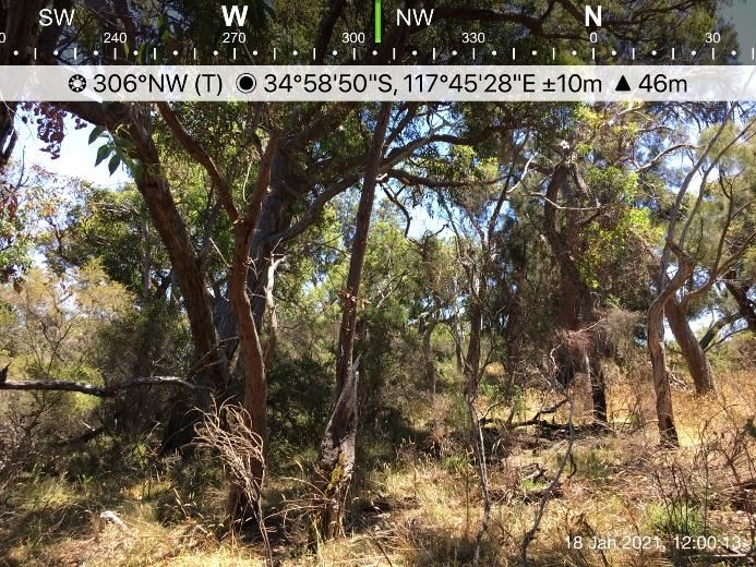
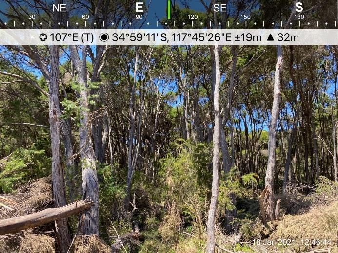
Environmental Assessment Report and Operations Plan Lots 6767 & 561 Howell Road

4. Site Assessment
Site assessment of the property and extraction area was undertaken on 18th January 2021 by Kathryn Kinnear and Bianca Theyer (Bio
Diverse Solutions). This assessment included ground truthing of desktop findings including bushfire risks to 150m. No detailed flora,
vegetation and fauna surveys were undertaken as the areas of intact remnant vegetation within the property will not be cleared during
this extraction project. Broad vegetation assessment and general comments on condition of remnant vegetation and stands of paddock
trees of the property are provided below. Albany Regional Vegetation Survey vegetation units have been used to assist in the mapping
of vegetation types within the site. Refer to Appendix B for Native Vegetation Mapping and Site Vegetation Mapping.

   4.1. Vegetation Types
Grassland
This vegetation type occurs across the entire subject site as the land is used for grazing/agricultural purposes. All native vegetation
has been cleared (except for several stands and individual mature trees) and now consists of bracken fern, introduced pasture species
and some other introduce weed species such as *Conyza sp. and *Hypochaeris sp., *Phalaris sp. The vegetation has been classified
as “completely degraded”. There are scattered paddock trees throughout this vegetation type that appear to be in poor health. Please
refer to Figure 2 and Table 1 for condition ratings.

 Figure 2: Photographs of the Grassland vegetation type and some images of paddock trees in poor / deteriorating health.

There is one tree (Eucalyptus staeri) within the grassland area that has evidence of arboreal mammal utilisation. There were
scratchings up the trunk leading to a small hollow (approx. 8x8cm) with some evidence of rubbing / chewing around the entrance. No
scats were observed at the base of the tree. The tree is in deteriorating health and is approximately 76m from the remnant vegetation
in the north of the property. Given it is a single tree in the paddock it holds reduced value in comparison to the nearby and surrounding
vegetation. It is highly likely the individual is utilising the remnant vegetation for feeding and refuge in addition to this tree, and is
unlikely to negatively impact the individual if removed. Refer to Figure 3 below.

MSC0324                                                     18 February 2021                                                        6
Environmental Assessment Report and Operations Plan Lots 6767 & 561 Howell Road

 Figure 3: Photographs of Eucalyptus staerii tree with evidence of arboreal mammal utilisation.
Taxandria juniperina closed forest
This vegetation type lies within the low-lying wet areas of the subject site and along the southwestern boundary of the property in
adjacent undeveloped road reserve. The vegetation type is dominated by an overstorey and midstorey of Taxandria parviceps. The
midstorey and understorey is very disturbed and non-existent in some areas, there are some scattered native species such as Hibbertia
sp., native sedges and Pteridium esculentum. There is a high percentage of weed species present such as *Psoralea pinnata,
*Paspalum distichum (water couch), *Cenchrus clandestinus, and large areas infested with *Rubus sp. (blackberry).
This vegetation type has been disturbed which is evident though the reduced understorey composition, high levels of weed infestation
and presence of cattle in the area and is therefore classified as being in “Good” condition. Please refer to Figure 4 and Table 1 for
condition ratings.

 Figure 4: Photographs of the Taxandria juniperina closed forest vegetation type.

MSC0324                                                  18 February 2021                                                      7
Environmental Assessment Report and Operations Plan Lots 6767 & 561 Howell Road

 Figure 4 continued.

Jarrah/Marri/Sheoak Laterite Forest
This vegetation type is located within the remnant vegetation within the north of the property as well as the surrounding vegetation in
adjacent land to the west, north and east. During the site assessment overstorey species identified were Eucalyptus marginata,
Allocasuarina fraseriana and Corymbia calophylla. Midstorey species include Nuytsia floribunda, Kingia australis, Banksia grandis,
Acacia sp., Taxandria parviceps, Leucopogon verticillatus, Beaufortia decussata, Adenanthos obovatus, Adenanthos cuneatus and
Melaleuca sp. Understorey species consisted of Pteridium esculentum, Xanthorrhoea preissii, Dasypogon bromeliifolius Patersonia
sp., Lepidosperma sp., *Psoralea pinnata, *Cenchrus clandestinus, *Hypochaeris sp. and other pasture weed species. Due to the
obvious signs of disturbance (weeds species, reduced understorey in some areas and clear signs of cattle grazing in the northern
portion) the vegetation has been classified as “Very Good” to “Excellent”. Please refer to Figure 5 and Table 1 for condition ratings.

 Figure 5: Photographs of the Jarrah/Marri/Sheaok Laterite Forest vegetation type.

MSC0324                                                   18 February 2021                                                       8
Environmental Assessment Report and Operations Plan Lots 6767 & 561 Howell Road

 Figure 5 continued.

Table 1: Condition Rating Scale
 Vegetation Condition Rating      Description
 Pristine                         Pristine or nearly so, no obvious signs of disturbance.
 Excellent                        Vegetation structure intact, disturbance affecting individual species and weeds are non-
                                  aggressive species.
 Very good                        Vegetation structure altered, obvious signs of disturbance.
 Good                             Vegetation structure significantly altered by very obvious signs of multiple disturbances. Retains
                                  basic vegetation structure or ability to regenerate to it.
 Degraded                         Basic vegetation structure severely impacted by disturbance. Scope for regeneration but not to
                                  a state approaching good condition without intensive management.
 Completely Degraded              Vegetation structure not intact; the area completely or almost completely without native species.

MSC0324                                                18 February 2021                                                         9
Environmental Assessment Report and Operations Plan Lots 6767 & 561 Howell Road 5. Proposed Development 5.1. Extraction process, staging and haulage routes The location and extent of the proposed gravel extraction area is shown in Appendix A – Location and Site Facility Mapping covering an area of 19.9 hectares in total of cleared agricultural land. It is assumed that the extraction area will provide 200,000 m3 (350,000 tonnes) of gravel over the lifetime of the pit. It is expected that 30,000 tonnes will be extracted per year. In times of high demand, it is expected a maximum of 50,000 tonnes per year will be extracted. Ultimately the amount of extracted materials will be reliant upon industry demand. Cosla Pty Ltd expect that in high demand periods, one stage within the proposed project will be exhausted every 12 months. Extraction is planned to commence as soon as possible after all required approvals are obtained. The extraction facility will be gated and locked, with no unauthorised persons able to enter. Refer to Implementation Plan Section 8. Stages have been split across two categories “sand extraction” and “gravel extraction” (please refer to Staging Plan in Appendix A). Cosla Pty Ltd anticipates that sand and gravel will run concurrently throughout the life of the pit (i.e., sand and gravel will be extracted at the same time). However, only one pit in each stage category will be open at any given time. The extraction of gravel including crushing and screening will take place on site by yet to be appointed contractors under the direction of Cosla Pty Ltd Pty. Extracted products will then be transported to various construction sites within the City of Albany and adjoining areas. A mobile plant is utilised to push up and stockpile topsoil as well as to extract, push up and stockpile gravel. Unprocessed gravel is fed into the crushing and screening plant, and then stockpiled prior to being loaded onto trucks. No blasting will be required, whilst portable crushing and screening equipment will be utilised, the crushing of large gravel “boulders” will only occur when required and it is therefore expected that most of the extracted resource will not require crushing. It is proposed that extraction will be staged with the stages depicted on the Staging Map (Appendix A). Within these stages one of the pits (average 1ha but ranging from 0.85ha to 1.5ha in size) will be exposed/operated at any given time. This area will then be rehabilitated / closed up (covered with topsoil) and a remaining area of the stage will be opened. Gravel will be stockpiled within the stage / pit area adjacent to the open pit, for use as demand requires. It is estimated that the maximum amount of time gravel will be stockpiled is 6-12months. Stockpiles will be no higher than 4 metres. Trucks will access the property via the existing site entry along Howell Road. This access route allows for trucks to head in an easterly or westerly direction from the existing Howell Road and South Coast Highway intersection. 5.2. Vegetation and Topsoil Removal No native vegetation will be cleared as part of this proposal. Scattered paddock trees that are in poor health will be removed as the extraction area consists of approximately 19.9 hectares of agricultural land. Topsoil will be removed to a depth of 150 – 200mm with the maximum depth of excavations to 1500mm below ground level. All topsoil removed will be stockpiled in windrows 5-8m wide and stored parallel to the borders of the extraction area. Topsoil will be stockpiled in piles no higher than 4m which will then be respread over the pit area once excavation activities have ceased, the ground has been ripped and all stockpiled materials removed. This will be done as the client wishes to continue agricultural practices once the extractive proposal has ceased. 5.3. Operation Times Extraction and plant operation times will be restricted to the hours between 7:00am and 5:00pm Monday to Friday and 8:30am to 1:00pm on Saturday (in times of high demand / peak periods), not including Public Holidays. Actual operation times will vary as a result of product demand, if demand is low due to no construction projects being carried out then the facility will not be operational. 5.4. Vehicles and Machinery No hydrocarbons, chemicals, fuels, coolants etc. will be stored onsite. These will be transported onsite as required by a contained mobile service vehicle which will be appropriately equipped with spill kits in the unlikely event there is a spillage. Furthermore, no trucks will be stored on site outside of operation hours, only screening and crushing equipment will be stored on site. If major servicing of these machines is required, they will be removed from site. In the unlikely event of a major breakdown on site all necessary precautions to ensure no hydrocarbons or other liquids enter the environment, and any contaminated soil will be removed and disposed of at an appropriate location. MSC0324 18 February 2021 10
Environmental Assessment Report and Operations Plan Lots 6767 & 561 Howell Road

6. Environmental Considerations
   6.1. Noise
Cosla Pty Ltd will ensure all extraction, crushing and screening operations are to be carried out only between 7:00am and 5:00pm
Monday to Friday and 8:30am to 1:00pm on Saturday (in times of high demand / peak periods), not including Public Holidays.
The surrounding properties are also zoned as “General Agriculture” and it is expected that operational noise will not be louder
than the surrounding agricultural and forestry operations within the immediate vicinity.
Noise considerations are subject from 3 key areas:

     •    Extraction processes (excavation, pushing and moving material on site);
     •    Crushing and screening; and
     •    Truck and vehicle movements to and from site.
Extraction processes
The extraction processes involve the stripping of topsoil and mounding, ripping and pushing of ripped material for export off site
or for crushing (if required). The estimated times for this process for 1 ha (i.e. a stage) is:

     •    1 day - Strip/ push up topsoil;
     •    1 day - Rip entire area;
     •    1-2 days - Push up ripped material for export/crushing; and
     •    Crushing material depending on size and requirement of resource by client:
               o Low demand: 0 - 3 days.
               o High demand / peak periods: 7 days.
The volume and amount required is purely dependant on demand. Location of extraction and staging is defined in Appendix A.
The extraction areas shall be located a minimum of 300m from neighbouring residential areas consistent with the City of Albany
Guidelines to Sensitive Land Uses as shown on Site Buffers Mapping in Appendix A. Extraction areas are situated 40m from the
adjacent road reserve (unformed) along the western and northern property boundary, 20m off the adjacent property boundary to
the east and internal native vegetation, 50m from dams and 100m from waterways/waterbodies (other than dams).
There are three residential properties within 1km of the extraction project. The dwelling to the southwest is located 409m to the
nearest stage / pit. This dwelling is in rundown condition but there was some evidence of recent habitation and therefore has
been included as a sensitive receptor for this project. The dwelling to the south is located 449m from the nearest stage / pit. The
dwelling to the southeast is located approximately 826m from the nearest stage / pit. There are two more dwellings to the
southwest of the property that are greater than 1km away from the nearest stage / pit. Refer to Site Buffers Mapping in Appendix
A.
A bund will be constructed along the southern and western and southern boundary of the extraction area to reduce noise to
neighbouring residential properties. The bund will be between 2 and 4m high. This noise bund will be the stockpiled topsoil from
each stage and at 2-4m high will ensure the operations are visually obscured and noise is contained within the site.
To create noise (and visual) buffers, the client will utilise the topsoil mounds around the perimeters of the extraction stages / pits
as they are established. Traffic routes internal to the site will be planned out in such a way as to minimise vehicle reversing
requirements and thus minimise reversing alarm noise (particularly for the nearest residences). Replacing standard “beeping”
reversing alarms with a mixed frequency alarm (which does not carry as far) should also be considered to further reduce noise
issues.
In conjunction with these activities, regular maintenance of onsite plant and machinery will help to reduce unnecessary noise
pollution. Any equipment identified as noisy will either be removed from site or its use terminated until repairs are made.
All employees and contractors will be educated through site inductions raising awareness and outlining company practices will
be employed to help mitigate noise pollution whilst on site and when entering and exiting the property. It will be the site manager’s
responsibility to ensure all personnel adhere to noise reduction measures.

MSC0324                                                      18 February 2021                                                        11
Environmental Assessment Report and Operations Plan Lots 6767 & 561 Howell Road A noise and dust complaint system/register should be implemented to ensure any complaints are dealt with appropriately. A notice should be placed at the front gate providing the contact details of the site manager. Any noise or dust related complaints will be recorded by the site manager and acted on immediately and resolved within 24 hours. Any complaints made should be kept in a register. Refer to Section 7.2 for Noise Management to be implemented during all operations. Crushing and screening Noise from crushing and screening operations will be the largest consideration to the project. Crushing and screening operations will be only undertaken in the designated crushing and screening extents within the pits to create further buffers to neighbouring residents and sensitive receptors. The current endorsed EPA Separation Distances between Industrial and Sensitive Land Uses is Guidance No. 3 (2005) whereby noise (and dust) is assessed on a “case by case” basis. The draft 2015 document outlines that a 500m to 1000m buffer is considered appropriate and has been given due regard in the preparation of this document. The crushing and screening areas shall be located at least 500m from the neighbouring residential properties where able to be achieved, with most areas of crushing and screening between 500m and 1000m from the residential properties. Where this cannot be achieved due to logistics in the pits, the area is to be classified as “Sensitive Operations” areas. All proposed crushing and screening areas are to be licensed via DWER and a Works Approval application to be submitted for the operations. The “Sensitive Operations” area ensures the maximum time taken for any one pit to push up ripped material for crushing is 3 days per week. This will ensure that noise is limited reducing the risk to adjacent properties, see further information in section 7.2. Truck movements Truck movements and noise is deemed to be low along Howell Road adjacent to the subject site as trucks will be at low speed and low gearing to enter and exit the property. Road and truck noise is more probable along the road length to the south along South Coast Highway (haulage route to the south of the subject site) from other existing agricultural and industrial land uses. The extraction and subsequent carting of the gravel material is subject to demand and truck movements, noting on some days will be nil to minimal, whilst other days may be subject to a higher demand. 6.2. Dust and Erosion Dust emissions are anticipated during topsoil removal, resource excavation, crushing and screening, loading, haulage and wind erosion of exposed surfaces in adverse weather conditions. However, dust management will be implemented in order to mitigate dust emissions, ensuring dust levels cannot reach levels that adversely impact health, welfare, surrounding amenities and the environment. All topsoil stockpiles and stockpiled gravel will be no greater than 4 metres in height. Long-term stockpiling will be avoided where possible and will be dependent on demand, it is expected stockpiling will range between 6-12months. Stockpiles will not be located in areas subject to adverse environmental conditions (e.g. prevailing winds) such as prominent ridges, and will be located within the stage or extraction pit currently in operation. Operations will temporarily cease during times of high winds, and water trucks and water shall be available to supress dust. At the sign of any erosion, measures shall be put in place to mitigate any further erosion. All post development runoff is contained onsite within drainage basins, table drains and well-draining soils. A noise and dust complaint system/register should be implemented to ensure any complaints are dealt with appropriately. A notice should be placed at the front gate providing the contact details of the site manager. Any noise or dust related complaints will be recorded by the site manager and acted on immediately and resolved within 24 hours. Any complaints made should be kept in a register. Refer to Section 7.1 for Dust Management to be implemented during all operations. 6.3. Light Extraction activities will not be conducted outside of daylight hours, therefore there will be no light emissions. 6.4. Discharges to land There will be no discharges to land. MSC0324 18 February 2021 12
Environmental Assessment Report and Operations Plan Lots 6767 & 561 Howell Road

   6.5. Wetlands
The extraction area is located 295m from the nearest conservation category wetland located to the northeast of the property. There
will be no impacts to this wetland. It is recommended that a minimum of 2 metres of undisturbed soil profile is required as a buffer
between the base of the excavated area and the maximum groundwater level.

   6.6. Discharges to water
There will be no discharge to surface or ground water. Surface water will be managed according to Section 7.4.

   6.7. Flora and Vegetation
Areas of remnant vegetation within the southern and northern portion of the property have been excluded from extraction stages. The
scattered paddock trees that are in degraded condition are proposed to be cleared. No other native vegetation is proposed to be
cleared as part of this project. There will be no discharges to land or water and this further reduces any risk to surrounding flora and
vegetation. Weed management will be undertaken to ensure no invasive weeds identified spread into the surrounding remnant
vegetation.

   6.8. Fauna
As the subject site is located in an area that has already been cleared and highly modified for agricultural practices, there will be no
further impacts to fauna than are already present.

MSC0324                                                    18 February 2021                                                      13
Environmental Assessment Report and Operations Plan Lots 6767 & 561 Howell Road

7. Management Plans
   7.1. Dust management
Dust has potential to impact on the surrounding social and natural environment through decreases in visibility, air quality, vegetation
health and general amenity.
Crushing and screening operations have the potential to generate dust through:

     •    Land clearing, vegetation and topsoil removal;
     •    Excavation, crushing and screening, transfer and loading of product for haulage;
     •    Wind erosion from topsoil stockpiles and other exposed surfaces;
     •    Use of access tracks; and
     •    Topsoil spreading during rehabilitation.
Dust emissions are anticipated during topsoil removal, resource excavation, crushing and screening, loading, haulage and wind erosion
of exposed surfaces in adverse weather conditions. However, dust management can be implemented in order to mitigate dust
emissions, ensuring dust levels cannot reach levels that adversely impact health, welfare, surrounding amenities and the environment.
All topsoil stockpiles and stockpiled gravel will be no greater than 4 metres in height. Long-term stockpiling will be avoided but will be
dependent on demand. Stockpiles will not be located in areas subject to adverse environmental conditions (e.g., prevailing winds) such
as prominent ridges, and will be located within the stage or extraction pit currently in operation. Operations will cease during times of
high winds (i.e., if visible dust seen leaving the property), and during times when a north easterly wind is present. Water trucks and
water will be used to supress dust via a tanker on site. At the sign of any wind erosion, measures shall be put in place to mitigate any
erosion. Measures to mitigate erosion include (but are not limited to) contouring of soils, surface water management (i.e., directing
surface water away from the area if necessary) and bunding.
The aims of the dust management plan are to:

     •    Ensure dust is not prevailing over adjacent residences and properties;
     •    Maintain a dust free working environment for all employees on site;
     •    Ensure all employees and sub-contractors are educated to minimise dust from all operations; and
     •    Ensure dust is controlled and minimised at all times.
The following is to be implemented by Cosla Pty Ltd during operations:

     •    Construction of a 2-4m bund along the western and southern boundary of the extraction area and parallel to any excavation
          areas;
     •    Land clearing will be kept to the minimum required for the project, and clearing and topsoil stripping will be avoided on high
          wind days;
     •    Extraction will be carried out in stages as the project progresses to minimise dust generation from cleared areas;
     •    All crushing and screening to occur within the designated boundary of the crushing and screening extents;
     •    Topsoil mounds to be no greater than 4 metres in height;
     •    Stockpiles to be located in pit areas and along the edge of pits to assist in noise and dust reduction to the properties and will
          be no greater than a height of 4m;
     •    Gradual rehabilitation will be undertaken to minimise the area of exposed surfaces;
     •    Stockpiles to be configured to accommodate easy access for watering/dust minimisation;
     •    The access road, immediate extraction area and fixed plant (screen) to be watered as required to minimise dust emissions;
     •    Manage operations to minimise work in windy conditions to minimise dust emissions. Works only to occur in low velocity
          winds (i.e., operations to cease if visible dust seen leaving the property);
     •    Visually monitor emissions of dust from the works, if dust is visible water trucks are to be utilised to supress dust and / or
          operations are to cease temporarily;
     •    Works to cease temporarily if visible dust is seen leaving the site when there is a north easterly wind and dust suppression
          measures (i.e., water application to area) implemented;
     •    Trucks to be fully covered by tarpaulins when fully loaded, prior to leaving extraction area;

MSC0324                                                     18 February 2021                                                        14
Environmental Assessment Report and Operations Plan Lots 6767 & 561 Howell Road
• Vehicle travel speeds will be restricted to 40 km/hour on unsealed surfaces on site;
• Education to employees and sub-contractors to raise awareness of dust management issues; and
• Dust complaint register located on the front gate to record any issues from neighbours. A contractor sign at the front gate to
be erected clearly showing Cosla Pty Ltd contact details.
7.2. Noise Management
The noise management plan is to be implemented by Cosla Pty Ltd at all times of operation.
The aims of the Noise Management measures are to:
• Ensure compliance with Environmental Protection (Noise) Regulations 1997;
• Ensure noise does not significantly impact adjacent residences and properties;
• Define “Sensitive Operations” to occur for crushing and screening operations close to sensitive receptors;
• Ensure all Cosla Pty Ltd employees and sub-contractors are educated to minimise noise from all operations; and
• Ensure noise is controlled and minimised at all times.
The following actions are to implemented by the contractor during excavation operations:
• Construction of a 2-4m bund along the western boundary of the extraction area for noise attenuation. The bund is the
stripped topsoil and mounded parallel to the pit to reduce noise to offsite receptors;
• All plant movements, extraction, crushing and screening operations are to be carried out between 7:00am and 5:00pm
Mondays to Fridays, and 8:30am to 1:00pm on Saturday (in times of high demand / peak periods), not including Public
Holidays;
• Mounding of topsoil along the edge of pits to act as noise bunds to further reduce noise at nearby properties, mounding is
to be parallel to the excavated pit and maintained regularly for any defects and stabilised for dust management;
• Ensuring crushing and screening plant remains more than 500m from the closest adjacent residence (sensitive receptor).
Where this cannot be achieved, “Sensitive Operations” occurs, see below for further information;
• Regular inspections of all plant and machines on site to ensure all are working and functioning correctly, without excess
noise;
• Regular inspections of bunds to ensure noise is contained within the site and bunds are to required specified heights;
• Turning off equipment when not in use;
• Regular inspections of road trains and trucks used for carting to ensure all muffler and exhaust systems are functional,
specific to noise attenuation;
• Vehicle travel speeds will be restricted to 40 km/hour on unsealed surfaces on site;
• Education to Cosla Pty Ltd employees and sub-contractors to raise awareness of noise management issues;
• Noise complaint register in place to record any issues from neighbours. A contractor sign at the front gate to be erected
clearly showing Cosla Pty Ltd contact details; and
• Any noise related complaints will be recorded by the site manager and acted on immediately and resolved within 24 hours.
Excavation processes
Excavation processes generate noise through the operation of machinery – dozers, excavators, light vehicles and trucks. These can
be considered commensurate with general farm vehicle agricultural operations. Adhering to the plan above will ensure there is no
adverse noise impact from excavation processes on the site.
Crushing and screening
Crushing and screening operations generate noise through the operation of machinery, crushing and screening plant. This noise has
potential to impact on nearby sensitive receptors and is required to comply with the Environmental Protection (Noise) Regulations
1997. All crushing and screening operations is to be licensed by the Department of Water and Environmental Regulation (DWER) as
per the EP Act “prescribed premises”. The regulation and compliance of the crushing and screening operations are via the DWER
License for the premises as issued under the EP Act.
No blasting will be required, whilst portable crushing and screening equipment will be utilised, the crushing of large gravel
“boulders” will only occur when required and it is therefore expected that most of the extracted resource will not require crushing.
MSC0324 18 February 2021 15Environmental Assessment Report and Operations Plan Lots 6767 & 561 Howell Road
“Sensitive Operations”
Noise emitted from crushing and screening is subject to regulation and compliance under the EP Act. Crushing and screening
operations are likely to be limited to the amount and volume required for the product and subject to demand. It is estimated the majority
of the resource will not require crushing and screening however this will not be confirmed until each pit is exposed. Where any crushing
and screening occurs within 500m of a sensitive receptor this will be limited to 3 days per week and from 8.30-5pm weekdays only.
This will reduce the frequency of exposure to adjacent residents and therefore reduce the impact/risk of this emitting source to health
and wellbeing. A detailed risk assessment of the crushing and screening processes proposed on site will be performed to accompany
the works approval to DWER.
As mentioned in Section 1.1 of this document, the activity of crushing and screening is only examined in this document as a component
of the noise management plan. Buffers, setbacks and licensing conditions are to be dealt with by DWER as part of a works approval
application by the proponent.
Truck and vehicle noise
Truck movements and noise is deemed to be low along Howell Road adjacent to the subject site as trucks will be at low speed and
gearing to enter and exit the property. Road and truck noise is more probable along the road length to the south along South Coast
Highway (haulage route to the south of the subject site) from other existing agricultural and industrial land uses.
The extraction and subsequent carting of the gravel material is subject to demand and truck movements on some days will be nil to
minimal, whilst other days may be subject to a higher demand.
7.3. Truck Movements
Cosla Pty Ltd will engage a local contractor to carry out the crushing and screening activities. In general contractors in the Albany area
use two types of trucks, the capacities are approximately 15 tonnes for the 6-wheeler trucks and 24 tonnes for a semi-trailer. Truck
movements (2 movements = 1 truck would enter and exit the site per day) will be dependent on demand of materials. On average it is
expected there will be 5-6 truckloads per day, which equates to 10-12 truck movements per day. When demand is low it is expected
0-2 movements per day will occur. Truck signs are to be installed prior to operations commencing before the access point along Howell
Road and South Coast Highway, warning of truck movements. Cosla Pty Ltd has been in contact with Main Roads WA and they have
indicated there are no issues with the Howell Road and South Coast (Western) Highway Intersection. Refer to Appendix E
7.4. Stormwater Management
The overall extraction area will be designed, constructed and operated to avoid disruption to surface water flows, minimise erosion
and ensure that potential contaminants are not released into the environment. Stormwater management measures are:
• The site will be graded along contours to ensure that all stormwater, wash-down and spillage water run-off is either directed
to a low point within the prescribed premises, or a collection and settling basin from where it can be recycled for dust
suppression purposes;
• Perimeter bunding will be installed if required to minimize stormwater entering and exiting the site;
• Runoff from stockpiles diverted to low point within the prescribed premises;
• Contouring of pit edges to contain surface water;
• Encourage point source infiltration across the existing rural areas (future stages) and in rehabilitated areas; and
• Ensure all surface water is contained and treated on site.
Also refer to Section 7.13 for daily and weekly stormwater monitoring and controls of structures.
7.5. Weed Management
Weed management is to be used in conjunction with dieback hygiene management (See Section 7.6). The following Weed
Management Plan is to apply to all aspects of site operations. All operations shall conform to this Weed Management Plan, and
monitoring to occur post construction for any infestations. Weed management will primarily be undertaken through avoiding introducing
new weeds to the site, whilst also controlling weeds already present.
MSC0324 18 February 2021 16You can also read