Fish, Wildlife and Recreation Mitigation Plan
←
→
Page content transcription
If your browser does not render page correctly, please read the page content below
Chatfield Reservoir Reallocation Project
        Fish, Wildlife and
     Recreation Mitigation Plan

Prepared for:
The Colorado Parks and Wildlife Commission
In accordance with C.R.S. 37-60-122.2
Prepared by:
Chatfield Reservoir Reallocation Project Participants
                      January 2014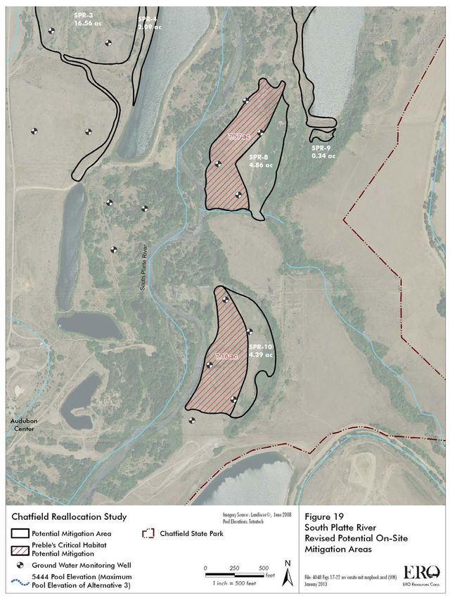
TableofContents

ExecutiveSummary

1.0 Introduction
       1.1 PurposeofDocument
       1.2 ProjectOverview
       1.3 RegulatoryProcesses
       1.4 Stakeholders

2.0 AvoidanceandMinimizationofAdverseImpacts
       2.1 AvoidanceandMinimizationofAquaticandWildlifeEnvironmentalImpacts
       2.2 AvoidanceandMinimizationofWetlandsandRecreationalImpacts

3.0 BenefitsoftheProject

4.0 MitigationofUnavoidableAdverseImpacts:FishandWildlife
       4.1 ReservoirOperationsPlan
              4.1.1 General
              4.1.2 Definitions
              4.1.3 SpecificProvisions
              4.1.4 AdaptiveManagementforOperations
       4.2 FisheriesandAquaticHabitat
              4.2.1 FisheryandAquaticHabitatintheSouthPlatteRiver
                 4.2.1.1     Habitat and Recreation in the South Platte above Chatfield
                             Reservoir
                 4.2.1.2     Habitat and Recreation in the South Platte below Chatfield
                             Reservoir
              4.2.2 FisheryandAquaticHabitatwithinChatfieldReservoir
              4.2.3 ChatfieldStateFishUnit
              4.2.4 AdaptiveManagementforAquaticLifeandFisheries
       4.3 FluctuationZone
              4.3.1 FluctuationZoneMitigationMeasuresOverview
              4.3.2 PlumCreekRestoration
              4.3.3 NoxiousWeedControlPlan
                 4.3.3.1     AdaptiveManagementforWeedControl
              4.3.4 ShorelineStabilizationPlan
       4.4 WaterQuality
              4.4.1 WaterQualitywithinChatfieldReservoir
              4.4.2 WaterQualityintheSouthPlatteRiverbelowChatfieldReservoir
              4.4.3 AdaptiveManagementforWaterQuality
       4.5 Wildlife,WetlandsandRiparianHabitat
              4.5.1 OverviewoftheCompensatoryMitigationPlan

                                               1
4.5.2   CMPMitigationApproach
              4.5.3   SummaryofCMPMitigationMeasures
              4.5.4   AdaptiveManagementforWildlife,WetlandsandRiparianHabitat
              4.5.5   TreeManagementPlan
              4.5.6   AdaptiveManagementforTreeClearingwithintheFluctuationZone

5.0MitigationofUnavoidableAdverseImpacts:Recreation
               5.1RecreationalFacilities
                   5.1.1RecreationalFacilitiesModificationPlan
                   5.1.2 MarinaReplacementPlan
                   5.1.3 HiringofTemporaryCPWResidentEngineer
               5.2 FinancialPlan

6.0 Schedule

7.0 Conclusions

References


                                               2
Figures
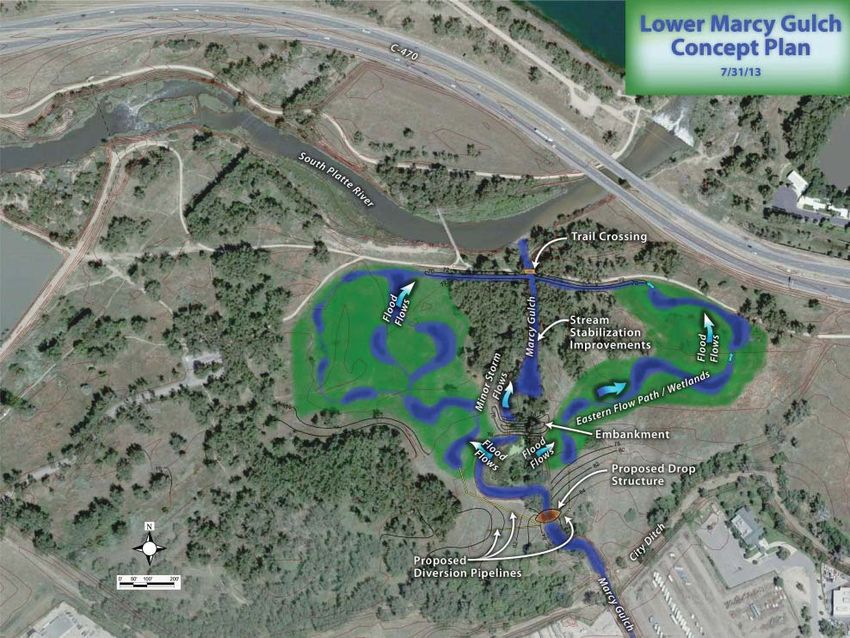
1 ProjectAreaMap
2 ChatfieldProjectParticipants’ServiceAreas
3 ReallocationAlternatives
4 PlumCreekExistingConditions(1)
5 PlumCreekExistingConditions(2)
6 PlumCreekConceptualStreamRestorationImprovements
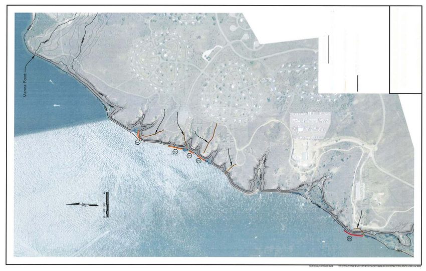
7 ShorelineStabilizationPlan
8 Preble’sHabitatatChatfieldStatePark
9 BirdHabitatatChatfieldStatePark
10 WetlandHabitatatChatfieldStatePark
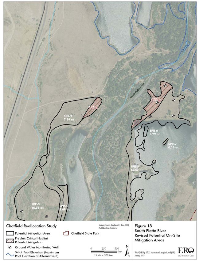
11 LocationsofProposedOnsiteMitigationAreas
12 LowerMarcyGulchPotentialOnsiteMitigationArea
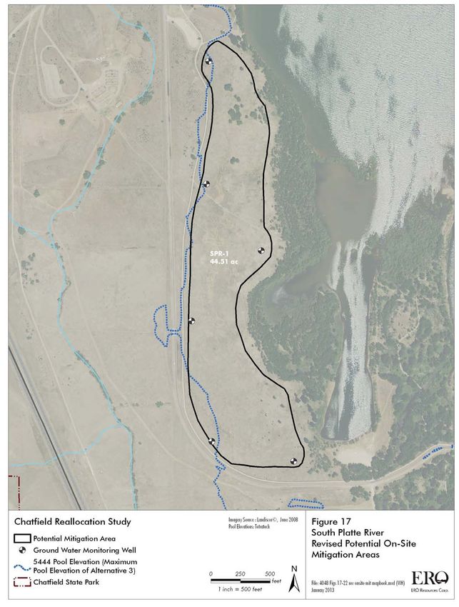
13 SouthPlatteRiverPotentialOnsiteMitigationArea(1)
14 SouthPlatteRiverPotentialOnsiteMitigationArea(2)
15 SouthPlatteRiverPotentialOnsiteMitigationArea(3)
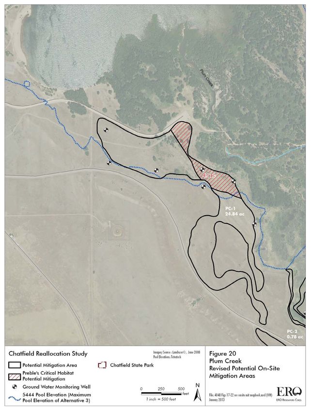
16 PlumCreekPotentialOnsiteMitigationArea(1)
17 PlumCreekPotentialOnsiteMitigationArea(2)
18 PlumCreekPotentialOnsiteMitigationArea(3)
19 AreasImpactedbyRecreationalFacilitiesRelocation,BorrowAreas,andHaulRoads
20 PotentialOffsiteMitigationAreas
21 SugarCreekOffsiteMitigationAreawithintheUpperSouthPlatte
22 PotentialPreble’sCriticalHabitatMitigationatSugarCreek
23 WestPlumCreekCriticalHabitatUnitforPreble’s
24 Bird Habitat Complex Targeted for Cottonwood Regeneration and Mature Cottonwood
Conservation
25 ChatfieldStateParkRecreationalAreas
26 ChatfieldMarinaExistingMarinaLocation(5,426’Elevation)
27 ChatfieldMarinaExistingMarinaLocation(5,440’Elevation)
28 ChatfieldMarinaExistingMarinaLocation(5,444’Elevation)
29 ChatfieldMarinaRoxboroughCoveMarinaLocation(5,426’Elevation)
30 ChatfieldMarinaRoxboroughCoveMarinaLocation(5,440’Elevation)
31 ChatfieldMarinaRoxboroughCoveMarinaLocation(5,444’Elevation)
Tables
1ProposedMitigationsforProposedAction
2Acute(1day)lowflows(cfs)forthe10yearperiod1Oct1999through30Sep2000forthe
SouthPlatteRiverbelowChatfieldDamtoMarcyGulch(fromAppendixJofFR/EIS)
3

Abbreviations

AF            AcreFeet(ameasureofwatervolumeequivalentto325,851gallons)
BMP           BestManagementPractice
CDPHE         ColoradoDepartmentofPublicHealthandEnvironment
CDWR          ColoradoDivisionofWaterResources
cfs           cubicfeetpersecond,ameasureofflowrate
CHU           Criticalhabitatunit(forPreble’smeadowjumpingmouse)
CMCC          ChatfieldMarinaCoordinationCommittee
CMP           CompensatoryMitigationPlan
CPW           ColoradoParksandWildlife
CRMC          ChatfieldReallocationMitigationCompany
C.R.S.        ColoradoRevisedStatute
CSFU          ChatfieldStateFishUnit
CWCB          ColoradoWaterConservationBoard
DNR           ColoradoDepartmentofNaturalResources
DWR           ColoradoDivisionofWaterResources
EDAW          EDAW,Inc.,aconsultingrecreationalplanningfirm(nowAECOM)
EFU           EcologicalFunctionUnit
EIS           EnvironmentalImpactStatement
ER            EngineeringRegulation
ERO           EROResourcesCorporation,aconsultingenvironmentalplanningfirm
ESA           EndangeredSpeciesAct
Fed.Reg.      FederalRegister
FEIS          FinalEnvironmentalImpactStatement
FR/EIS        FeasibilityReport/EnvironmentalImpactStatement
FWMP          FishandWildlifeMitigationPlan
msl           meansealevel
NEPA          NationalEnvironmentalPolicyAct
OHWM           OrdinaryHighWaterMark
PCT           ProjectCoordinationTeam
RFMP          RecreationFacilitiesModificationPlan
ROD           RecordofDecision
RSUA          ReallocatedStorageUsersAgreement
SWSI          StateWaterSupplyInitiative,astudybytheCWCB
TBD           Tobedetermined
USACE         U.S.ArmyCorpsofEngineers
USDA          U.S.DepartmentofAgriculture
USC           U.S.Code
USEPA         U.S.EnvironmentalProtectionAgency
USFS          U.S.ForestService
USFWS         U.S.FishandWildlifeService
WSA           WaterStorageAgreement
                                         4
ExecutiveSummary


This Fish, Wildlife and Recreation Mitigation Plan has been prepared in response to the
requirementsofC.R.S.§3760122.2.ItidentifiesactionsthattheChatfieldReservoirStorage
Reallocation Project Participants will implement to mitigate unavoidable adverse impacts the
Chatfield Reallocation Project will have on fish, wildlife, and recreation. (C.R.S. §3760122.2
does not require that a mitigation plan for recreation impacts be approved by the Colorado
Parks and Wildlife Commission, however, significant efforts will be undertaken to mitigate
unavoidable impacts to recreation facilities and amenities.  These mitigations are included
hereintoensurethatColoradoParksandWildlifeconcernsarefullyaddressed).

TheChatfieldReservoirStorageReallocationProject(Project)isaprojectwherebyagricultural
and municipal water users will use reallocated space in an existing federal facility to develop
new watersupplies. Chatfield Reservoir is a 350,653 acre foot (AF) reservoir south of Denver
builtandoperatedbytheU.S.ArmyCorpsofEngineers(USACE).

The USACE currently allows 27,405 AF of water to be stored in Chatfield Reservoir for
recreational,environmentalandwatersupplybenefits.TheProjectwillreallocateanadditional
20,600AFoffloodspaceforwaterstoragetobenefitagriculturalandmunicipalwaterusersin
the South Platte Basin resulting in up to 48,000 AF of storage space for recreational,
environmentalandwatersupply.

The Project began in 1996, when the Colorado Water Conservation Board (CWCB), as the
Projectsponsoronbehalfof15waterproviders,formallyrequestedthattheUSACEconsider
reallocating space within Chatfield Reservoir. This request was in response to a 1986
CongressionalauthorizationallowingtheUSACEtodeterminewhetheradditionalwatercould
be stored in the reservoir for water supply benefits whilenot compromising Chatfield’s flood
controlfunction.TheUSACEhasdeterminedthatupto20,600AFofspacecanbereallocated
withoutdiminishingthereservoir’sfloodcontrolcapability.TheProjectParticipantscurrently
includeelevenmunicipalandagriculturalwaterusersandtheCWCB.

This Project will contribute to meeting a portion of the water supply needs of the Project
Participants.Thereallocationof20,600acrefeetofstorageisestimatedtoresultinanaverage
annual yield of 8,500 acrefeet of new water supplies.  The CWCB Statewide Water Supply
Initiative(SWSI)projectedthatColorado’spopulationwillnearlydoubleby2050.Thismeans
thatthewatersupplyshortageintheSouthPlattebasin(includingtheDenverMetroarea),will
beatleast100,000AFperyearassumingthatpreviouslyidentifiedprojectssuchasChatfield
Reallocationare100%successful.Totheextentthatidentifiedprojectsarenotallsuccessful,
the gap in the South Platte and Metro basins could be as large as 360,000 AF per year.  As
showninTable12oftheFR/EIS,thewatersupplyshortageforprojectparticipantsin2020is
119,200 AF with 85,000 AF of the shortage coming from agricultural participants. The

                                                      5
opportunitytouseanexistingreservoirtostorewateranddevelopnewsurfacewatersupplies
partiallyaddressesthissignificantwatersupplyneed.

TheFinalFR/EISidentifiesthereallocationof20,600AFastheTentativelyRecommendedPlan.
TheFinalFR/EISwasmadeavailablefora90daypublicreviewfromJunethroughAugust,2012,
andtheFinalFR/EIShasbeenmadeavailablefora30daypubliccommentperiodbeginningon
August2,2013.TheRecordofDecisionisprojectedtobeissuedbylate2013orearly2014.

The Project is located in Chatfield State Park, managed by the Colorado Parks and Wildlife
(CPW).  Environmental resources at Chatfield State Park will be negatively impacted by
increased water storage in Chatfield Reservoir.  Higher water levels will inundate some
recreation facilities and environmental resources that have developed around the reservoir
sinceitwasconstructed.Inits38yearsofoperation,thereservoirgenerallyhasbeenmanaged
to maintain water levels within a 9foot range (elevation 5,423 – 5,432 feet above mean sea
level (msl)).  The Project will result in an additional 12 feet of water level fluctuations. The
ProjectwillalsoimpactenvironmentalresourcesaboveandbelowChatfieldReservoir.More
detail regarding the actions to mitigate all identified adverse impacts are described in the
FR/EIS.

ThestorageofadditionalwaterinChatfieldReservoirisalsoexpectedtohavebeneficialeffects
to the aquatic and wildlife environmental resources at or near Chatfield Reservoir.  These
beneficial effects will include improving the inreservoir fishery, enhancing raptor and bird
habitatasaresultofanimprovedinreservoirfishery,enhancingthehabitatforshorelineavian
speciesandflowaugmentationandprobabletemperaturereductionintheSouthPlatteRiver
belowthereservoirfromsummerandfallwaterreleasesfromChatfieldReservoir.Someofthe
mitigation measures will provide additional benefits beyond accomplishing the targeted
mitigations. For example, improving habitat in Sugar Creek for the Preble’s Meadow Jumping
mousewillhavetheadditionalbenefitofimprovinghabitatforthebrooktroutfisheryinSugar
Creek(anoffsitemitigationsite).

The Final FR/EIS identified what the USACE considers to be the Project’s significant adverse
impacts and the mitigations necessary to compensate for them.  Project Participants will
address additional environmental and recreational concerns identified by Colorado Parks and
WildlifethroughtheadoptionandimplementationofthisStateFish,Wildlife,andRecreation
Mitigation Plan.  This plan is a compilation of, and includes by reference, the following
documents:

     x TheFinalFR/EIS
     x TheCompensatoryMitigationPlan(CMP)(AppendixKoftheFinalFR/EISissuedon
         6/8/2012),
     x TheRecreationFacilitiesModificationPlan(RFMP)(AppendixMoftheFinalFR/EIS)
     x ThenewMarinaMitigationPlanbeingdevelopedfromanongoingstudy,
     x TheTreeManagementPlan(AppendixZoftheFinalFR/EIS),

                                                       6
x   TheUSACEAdaptiveManagementPlan(AppendixGGoftheFR/EIS),and
    x   ComparativeReviewofReservoirFluctuationZoneChatfieldReallocationProject
        (AppendixHHoftheFR/EIS)

There are two key contracts currently being developed for the Project, The Water Storage
Agreement (WSA) and the Reallocated Storage Users Agreement (RSUA).  The WSA is a
mechanismwherebytheUSACEgrantsthepermanentrighttostorageinChatfieldReservoirin
exchangeforcommitmentstofulfillallfinancialandmitigationobligations.TheWaterStorage
Agreement establishes an oversight committee, called the Project Coordination Team (PCT),
consistingofrepresentativesfromtheUSACE,StateofColoradoandProjectParticipants.The
PCT will oversee the implementation of all aspects of the project.  The USACE has ultimate
responsibilityforapprovalofProjectplansandthecompletionofmitigationrequirements.

The Chatfield Water Providers are committed to responsibly avoiding, minimizing and
mitigatingtheProject’sidentifiedadverseimpacts.Theadverseimpactstotheenvironmental
andrecreationalresourcescausedbytheProjectandtheproposedmeasurestomitigatesuch
impacts,includingcosts,aresummarizedinthefollowingTable1.


                                                    7
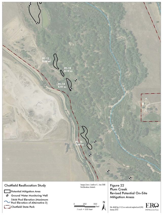
Table1:ChatfieldReallocationProjectFish,WildlifeandRecreationMitigationPlan(FWRMP)

ProposedMitigationsforProposedAction
RESOURCE                     IMPACT                                     MITIGATIONS                                                                                                                   SECTIONOFFWRMPWHERE ESTIMATEDCOST
                                                                                                                                                                                                         DISCUSSED

WILDLIFERESOURCES
WithinChatfieldStatePark
InReservoirAquatics
FishWalleye              DisruptionofWalleyeSpawnperiod          1)Participantscommittoensurereleasesdonotexceed420cfsduringMarch1April15period,understandingthat          4.1.3.3(B)(1)
                             March1April15                          criticaltimeisMarch1530.
                                                                          2)RegularcoordinationmeetingsbetweenParticipantsandCPWtoforecastupcomingoperationsclosecoordinationto
                                                                          minimizeadverseimpactfromreleases.

FishSmallmouthBass       DisruptionofSmallmouthBassspawn        MitigationdealtwithinoperationsagreementsParticipantscommittolimitreleasesMay1July15waterdeclinewillnot   4.1.3.3(B)(2)
                              periodJune1June30                   begreaterthan8000AFT,July16Aug31waterleveldeclinenotgreaterthan4000AFT,May1Aug31collectivedaily
                                                                          dischargeshallnotexceed420cfS
WaterQuality                Increaseinphosphateandammonia          1)ParticipantsagreetowaterqualitymonitoringandmodelingprogramincoordinationwithChatfieldWatershed               4.4.1;4.5;4.3.2      $1,300,000(est.)forwater
                              loading;                                   Authority.                                                                                                                                            qualitymonitoringand
                              DecreasedDissolvedOxygen;                2)WetlandcreationandhabitatimprovementsonPlumCreekintheCMP.                                                                                modeling,$6,088,600for
                              Increasedmercurymethylationfrom       3)PlumCreekriparianrestoration.                                                                                                                   PlumCreekrestoration
                              anoxicorincreaseddissolvedoxygenin
                              thereservoir

Terrestrialwildlife
Preble'sMousePlum        75acresofcriticalhabitat/65EFU's   1)FromCMP:Onsite:6acres/3EFUshabitatcreation.                                                                       4.5                    $58,500,000forCMP
CreekCriticalHabitat                                                   2)FromCMP:Offsite:unknownacresprivatelandprotectionandenhancement/62EFU'sneeded.
Preble'sMouseSouth       80acres/2.8miles                        1)FromCMP:Onsite:17acreshabitatcreation;                                                                               4.5
PlatteCriticalHabitat                                                  2)Offsite:73acresprivatelandprotectionandenhancement.ChatfieldResMitigationCompanywillcoordinatewCPWin
                                                                          thedevelopmentofthisprocess;
                                                                          3)4.5milesand381acresofSugarCreekimprovements

Preble'sMouseNon         298acres/210EFUs                       1)FromCMP:Onsite:111acresofhabitatcreation/43EFUs.                                                                 4.5
CriticalHabitat                                                         2)FromCMP:Offsite:unknownacresprivatelandprotectionandenhancement/167EFU'sneeded
Otherterrestrialwildlife   586acres(inundationzone)/377EFUs     1)FromCMP:Onsite:165acreshabitatcreationandenhancement/9birdEFU's.                                             4.5;4.3.2
andBirds                                                                2)PlumCreekRestorationPlan;
                                                                          3)Treemitigationplanwilladdressimpactsaswell.
                                                                          4)FromCMP:Offsite:unknownacres/368EFU'sneeded.

Amphibians/Reptiles        Groupedinto                               MitigationactionscoveredunderPreble’s/wetlands/terrestrialresources                                                      4.5
                              Preble’s/wetlands/terrestrial
Erosionoflandarea         Sedimenterosionduetonewstorage      1)Bankstabilization/Erosioncontrol/PlumCreekerosionandstreamerosion                                                4.3.4;4.3.2           $716,100forshoreline
/habitat                    andwaterfluctuation                                                                                                                                                                             stabilizationplan
CMP

                                                                                                                                  8
MatureCottonwoodsand        42.5acres                           1)13acresnewcottonwoodgenerationonsite(inCMP).                                                                     4.5.3;5.1.1;4.5.5;4.1.3.3
othercottonwoods                                                    2)22.5acresprotectionofexistingoffsitehabitat(inCMP).
                                                                      3)10acresnewcottonwoodgenerationoffsite(inCMP).
                                                                      4)Recreationmodificationplanwillmitigateforadditionalcottonwoods.
                                                                      5)Treemanagementplan.
                                                                      6)Resoperationsplanwaterlevelinsummer.

Wetlands                      upto159acres/123EFU's           1)InCMP:Onsite:47acres/30EFUs.                                                                                        4.5
                                                                      2)InCMP:Offsite:Unknownacres/93EFU's
InvasiveSpecies/Weeds       Increasedinvasives                   1)BMPstocontrolspread(inCMP).                                                                                           4.3.3
                                                                      2)Monitoringandtreatmentofnoxiousweedsinprojectarea(greaterthan400ft)
                                                                      3)Weedmonitoringandweedcontrolfor5yearsinrevegetation/mitigationsites(inCMPandAMP).
                                                                      4)Weedcontrolinfluctuationzoneisongoingobligation(inCMP).

DOWNSTREAMOFCHATFIELDSTATEPARK
AquaticResources
Downstreamaquatic   Decreasedstreamflowimpacton                 1)0.5miofstreamhabitatimprovement(ChatfieldDamtoMarcyGulch),potentialuseofCPWwaterrightstocreatean        4.2.1.2;4.1.3.3(D)            $265,000for.5mile
habitat              aquatichabitat;                               environmentalpooltomitigatelowflowdays.                                                                                                                 streamenhancement
                      Increasedlowflows/zeroflowdays           2)Besteffortstotargetreleasestolimitzeroflowdaysandmitigatewithenvironmentalpool.
                                                                      3)Potentialdevelopmentofenvironmentalpoolfortargetreleases(firstgoal)and/orenvironmentalflowreleases.
                                                                      4)Requiredreleasesforcriticallowflows.
AquaticHabitatwater       IncreaseE.colifromreducedflows;   1)Waterqualitymonitoringprogrambelowdam.                                                                                4.4.2;4.1.3.3(D)
quality                       Increasetemperaturefromreduced     2)Besteffortstotargetreleasestolimitzeroflowdays(inoperationsplanaddcitation).
                               flows                                 3)Requiredreleasesforcriticallowflows.
                                                                      4)Potentialdevelopmentofenvironmentalpoolfortargetreleasesand/orenvironmentalflowreleases.
ChatfieldStateFishUnit   Decreasedflows                       AgreenottoexerciserightsseniortothehatcheryifwouldcausecurtailmentofCSFUrights(onlyifhistoricflowswould   4.1.3.3(A);4.2.3
                                                                      havepassedbyCSFU).
                      Increaseinzeroflowdays                   Potentialdevelopmentofenvironmentalpooland/orenvironmentalflowreleases                                                4.2.1.2
UPSTREAMOFCHATFIELDSTATEPARK
Aquatichabitat        Inundationofupstreamfishhabitat         1)Fundhabitatimprovementfor0.7milesupstream.                                                                          4.2.1.1;4.5.3;4.3.2          $369,600for.7mile
                        Permanenthabitatconversionfrom            2)PlumCreedRestorationplan.                                                                                                                               streamenhancement
                        sedimentdeposition;                         3)WetlandsimprovementsinCMPmightmitigateintermittentstreammileage.
                        Lossofstreamchannelfornativefish     4)SugarCreekImprovements.
                        frominundationimpactsonPlumCreek

RECREATIONALRESOURCES
WITHINCHATFIELDSTATEPARK
FacilitiesandRecreational Lossoffacilitiesduetoinundation.   1)RMPdetailsmitigationmeasuresforfacilitiesandrecreationalusesincludescontingencyapproachthatgivestheplan   5.1.1;5.1.3                   $31,600,000for
Use                                                                  flexibility.                                                                                                                                                  recreationalfacilities
                                                                      2)NewtemporaryCPWengineeringemployeehiredduringdesignandconstructionofrecreationalfacilities                                                    modificationplan,
                                                                                                                                                                                                                                     $225,000(est.)for
                                                                                                                                                                                                                                     temporaryresident
                                                                                                                                                                                                                                     engineer
                             Marinaunusableduetoinundation   ChatfieldMarinaCoordinationCommittee(CMCC)workingonseparatemitigationplanforthemarina.                            5.1.2                          $15,700,000

                                                                                                                               9
                         Lossofwildlifeviewingandshade          1)CMP&TreeManagementPlansdetailmitigationforwildlifeviewingandshadePlumCreekrestoration(ifapproved)       4.5.3;4.5.5;4.3.2
                                                                        wouldaddressaccesstoviewingopportunities.
                                                                        2)13acresofonsitemitigation(formaturecottonwoods).
                                                                        3)32.5acresofoffsitemitigation.
                                                                        4)Treemanagementplanmodifiedtoleavetreesdownto5432anduseofadaptivemanagementtoremovedeadordying
                                                                        treeswithinthefluctuationzone.

                         Facilityvulnerabilitytofutureflooding   Couldbeaddressedinthedesignphasetoraisetheroadsbyswimbeach,balloonareaandDeerCreektomakeroadsstill   5.1.1
                                                                        abletohandle10yearfloods
                         QualityofRecreationalExperiences         1)Restrictreleasesto8,000ac/fttotalfromMay1July15thand12,000totaltoAugust31st.                          4.1.3.3;4.3.3;4.5.3;4.3.4;
                                                                        2)Fluctuationzonemitigationsthatincludes:vegetationandweedcontrol,newcottonwoodregenerationalongshoreline     4.3.2
                                                                        andfacilities,shorelinestabilizationplan,plumcreekimprovements.
                         IncreasedBoatingHazards                   Fundingofcontractlaborandequipmentforhazardremoval,signing,operationalimpactsduetoincreasedinundationand     5.2
                                                                        fluctuations.Operationalissueswillbecoveredinthefinancialmitigationplan.
                         WaterQualityraisedelevationcauses     1)Monitoringandmodelingofwaterquality.2)PlumCreekrestorationplan                                        4.4.1;4.3.2
                           erosionwhichwillaffectaccessbelow
                           campground
                         PublicUnderstanding                        1)ProjectParticipantshaveagreedtoamarketingplantobeimplementedpriortoconstructionandcontinuingafter         5.2                             $200,000
                                                                        constructioniscompletepartoffinancialmitigationplan,whenapproved.
Streamfishing            ReducedRecreationalOpportunities        1)Establishanenvironmentalpooltomitigatelowflowdaysuseofhatchery,downstreamuses.                           4.2.1.2;4.1.3.3(D)
                           reducedfishingfromadditionalzeroor     2)Mitigationof0.5miofstreamhabitatimprovement
                           lowflowdays                               3)Operationsplanlanguageofgoodfaitheffortstostrategicreleases.
Streamfishing           ReducedRecreationalOpportunities         1)0.7miofstreamhabitatimprovements.                                                                                    4.2.1.1;4.5.3
                          reducedfishingfromintermittent            2)SugarCreekimprovements
                          inundation
RevenueandOperatingExpenses
ParkRevenue             Decreasedrevenuesduring                   1)FinancialMitigationplan.                                                                                                5.2                             $1,000,000(est.)for
                          constructionandpostconstruction           2)WPtocoverlostrevenue                                                                                                                                   financialplan
ParkOperating            Increasedoperatingexpenses                WPtocoverincreasedoperatingcostsattributabletoproject                                                                5.2
EstimatedCostTotals
Costsformitigations                                                                                                                                                                                                           $107,100,000
requiredbytheUSACE
Additionalcostsfor                                                                                                                                                                                                            $8,864,300
FWRMPmitigations
TotalMitigationCosts                                                                                                                                                                                                          $115,964,300


                                                                                                                                  10
1.0Introduction
1.1PurposeofDocument
This Fish, Wildlife and Recreation Mitigation Plan (Mitigation Plan) has been prepared in
response to the requirements of C.R.S. 3760122.2 and identifies actions that the Project
Participants will implement to mitigate the unavoidable adverse impacts that the Chatfield
Reallocation Project will have on fish, wildlife, and recreation. The 122.2 Colorado Statute
requires that “fish and wildlife resources that are affected by the construction, operation or
maintenanceofwaterdiversion,deliveryorstoragefacilitiesshouldbemitigatedtotheextent,
and in a manner, that is economically reasonable and maintains a balance between the
developmentofthestate’swaterresourcesandtheprotectionofthestate’sfishandwildlife
resources”andthat“impactson[fishandwildlife]resourcesshouldbemitigatedbytheproject
applicantsinareasonablemanner.”
This Mitigation Plan includes mitigation for recreation impacts and represents the complete
mitigationpackageaddressingCPWconcerns.
1.2ProjectOverview
The proposed Chatfield Reallocation Project increases the beneficial components of Chatfield
Reservoirbyreallocatingstoragespacetofacilitatenewwatersupplydevelopment.
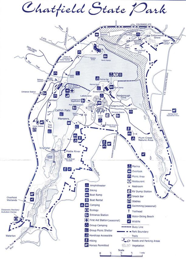
ChatfieldReservoirandChatfieldStatePark
Chatfield Reservoir is located within Chatfield State Park, southwest of Denver at the
confluence of the South Platte River and Plum Creek (Figure 1). The reservoir, owned and
operated by the USACE, was completed in 1975 to provide flood protection for the
metropolitanDenverareafollowingthedisastrousSouthPlatteRiverfloodof1965.
ChatfieldReservoirhas amaximumcapacityof350,653 acrefeet(AF).Upto27,405AFmay
currentlybestoredforrecreationalandwatersupplypurposes.DenverWateriscurrentlythe
only water user storing water in Chatfield Reservoir. In general the reservoir has been
managed to maintain water levelswithin a 9foot range (elevation 5,423 to 5,432 feet above
meansealevel(msl)).Theaveragerangeofmeanmonthlyelevationshasbeenapproximately
3 feet from low to high reservoir periods. The current Ordinary High Water Mark (OHWM)
elevationis5,432feetabovemsl.
Colorado Parks and Wildlife (CPW) manages recreation at Chatfield Reservoir and Chatfield
StatePark.ChatfieldStateParkcoversabout5,300acres,1,500acresofwhichincludeChatfield
Reservoir. The Park annually receives about 1.6 million “visitor days”, generating about $2.2
million in revenues that support operations and maintenance of Chatfield State Park and
contributetofundingtheStateparksystem.
11
Chatfield Reservoir is one of three walleye brood lakes statewide, providing up to 33 million
walleyeeggsforstockinginColoradowatersstatewide.TheSouthPlatteRiveraboveandbelow
the reservoir is utilized by anglers on a year round basis and, given its close proximity to the
DenverMetroarea,isparticularlyvaluablebecauseitprovidesanopportunitytofishcloseto
home.

CPWownsandoperatesafishdistributionhatcheryunit,locatedbelowthedamthatplaysa
criticalroleinenablingCPWtostockvariousfrontrangewatersinthespringandsummer.This
unit is intended to function as a fully operational hatchery but does not due to water
availabilitylimitations.

HistoryoftheChatfieldReservoirStorageReallocationProject

In 1986, in Section 808 of the Water Resources Development Act, Congress authorized the
USACEtoconductareallocationstudyforjointfloodriskmanagementconservationpurposes,
including whether storage for municipal and industrial water supply, agriculture, recreation,
and fisheryhabitat protection andenhancement could be accomplished without risk to flood
control.TheauthorizationrequiredthattheColoradoDepartmentofNaturalResources(DNR)
be the local sponsor for the reallocation and that the Chief of Engineers conclude the
reallocationisfeasibleandeconomicallyjustified.

In 1996, on behalf of 15 water providers, the Colorado Water Conservation Board (CWCB)
formally requested that the USACE consider reallocating space within Chatfield Reservoir for
watersupplypurposes.
In1999,aFeasibilityReportandEnvironmentalImpactStatement(FR/EIS)processwasinitiated
toconducttheanalysesrequiredbytheChiefofEngineers’findings(ER11052100,Ch.4).The
overallFR/EISstudyareaencompassestheareaintheimmediatevicinityofChatfieldReservoir
andextendsdownstreamtowheretheriverintersectstheAdams/Weldcountyline(Figure1).

TheFR/EISusedtheCWCB’sSWSI,andotherrelevantplanningstudies,toidentifyalternatives
for reallocation.  A total of 37 concepts were evaluated in the initial screening process. The
developmentofalternativestoreallocationandthescreeningprocessaredescribedindetailin
Chapter 2 of the FR/EIS. The FR/EIS evaluates, in detail, the environmental, social, and
economiceffectsoftheProposedRecommendedAlternative,aswellastwootheralternatives
andaNoActionalternative.

Thealternativereallocating20,600AFofstoragespaceinChatfieldReservoirisboththelocally
preferred plan and the USACE’s Tentatively “Recommended Plan” (hereinafter referred to as
the Chatfield Project). The average annual water yield from the Recommended Plan is
estimatedat8,500AF.Thisprovidesapartialsolutionfortheestimated360,000AFperyear
(year2050)gapinwatersupplyfortheFrontRangeidentifiedintheSWSIstudy.Totheextent
thatidentifiedprojectssuchasChatfieldReallocationare100%successful,theremaining2050
gapisstillestimatedtoberoughly100,000AFperyear.AsshowninTable12oftheFR/EIS,
the water supply shortage for project participants in 2020 is 119,200 AF with 85,000 AF the
shortagecomingfromagriculturalparticipants.
                                                       12
TheFinalFR/EISwasmadeavailablefora90daypublicreviewfromJunethroughAugust,2012,
and the Final FR/EIS is scheduled for completion by September 30, 2013.  The Record of
Decisionisprojectedtobeissuedbylate2013orearly2014.

TheChatfieldProjectParticipantsandtheirshareofthereallocatedstoragespace(Reallocation
Space)aregivenbelow.TheParticipants’serviceareasareshowninFigure2.

                                                      Storage      %ofTotal
                                                     Amount,AF

    1    CentralColo.WaterConservancyDist.         2,849.00        13.83%
    2    WesternMutualDitchCompany                  1,425.00         6.92%
    3    DenverBotanicGardensatChatfield               40.00        0.19%
    4    CentennialWaterandSanitationDist.         6,434.94        31.24%
    5    CastleRock                                   1,013.16         4.92%
    6    CastlePinesNorthMetroDist.                  941.58         4.57%
    7    CastlePinesMetroDist.                        785.58         3.81%
    8    SouthMetroWaterSupplyAuthority            1,418.42         6.89%
    9    MountCarbonMetroDist.                        400.00         1.94%
    10   CenterofColoradoWCD                          131.32         0.64%
    11   ColoradoWaterConservationBoard            5,161.00*        25.05%
                                                        20,600.00

*Note:CWCBstorageamountsubjecttochangependingtransferswithotherentities

Upon final approval of the Project, the Participants will be responsible for the operation,
maintenance,andrepairofinfrastructure,treatment,anddistributionfacilitiesassociatedwith
their water and their share of the Project rehabilitation and replacement costs.  The
Participants would fully fund the environmental mitigation and recreation modifications
necessarytomitigatetheimpactsofoperatingthereservoirunderthestoragereallocation.The
CPWwillbeintegralintheimplementationofthemitigationandwillbeabletoensurethesite
specific plans for onsite mitigation are acceptable and consistent with its management of
ChatfieldStateParkresources.

1.3RegulatoryProcesses

TheProjecthasundergonesignificantregulatoryscrutinyatthefederal,stateandlocallevels.
At the federal level, USACE performed extensive and detailed project feasibility and
environmentalstudiespursuanttoitsregulatoryandplanningrequirements.Theculmination
oftheprocessisajointFeasibilityReport/EnvironmentalImpactStatementthatwillserveas
thebasisforissuanceoftheDepartmentoftheArmyRecordofDecision(ROD).

The following federal, state and local regulatory approvals are required to implement the
Project:

                                                   13
    x   Federal:CompliancewithSection404oftheCleanWaterAct(CWA)fordredgeandfill
        activities in waters of the U. S. associated with the recreational facilities modification
        planandothermitigationincidenttothereallocation;CompliancewithSection7ofthe
        EndangeredSpeciesAct(ESA)relatedtoimpactstoPreble’smouseanditsdesignated
        critical habitat; and U. S. Forest Service (USFS) approval for work on USFS land (along
        SugarCreek).

    x   State:  Approval by CPW Commission and the Colorado Water Conservation Board of
        this Fish, Wildlife, and Recreation Mitigation Plan pursuant to C.R.S. §3760122.2;
        Colorado Departmentof Public Health and Environment (CDPHE)construction permits
        forairquality,waterqualitycertificationforanydischargerelatedmitigationactivities,
        andpermitsforstormwaterandconstructiondewatering.

    x   Local:DouglasCountypermitsforconstructionworkalongSugarCreekandatChatfield
        Reservoir;andJeffersonCountypermitsforconstructionworkatChatfieldReservoir.

1.4Stakeholders

Thestakeholderentitiesinclude:

       x Federal:USACE,USEPA,USFS,andUSFWS;

       x State:DNR,CWCB,CPW,DWRandCDPHE;

       x Local:(InadditiontotheProjectParticipants)DenverWater,CityofLittleton,South
          SuburbanParksandRecreationDistrict,CityandCountyofDenver,DouglasCounty
          Commissioners, Jefferson County Commissioners, Weld County Commissioners,
          MetroWastewaterReclamationDistrict,ChatfieldWatershedAuthority,andUrban
          DrainageandFloodControlDistrict;and

       x Nongovernmental organizations: The Greenway Foundation, Audubon Society of
          GreaterDenver,ColoradoEnvironmentalCoalition,SierraClub,WesternResources
          Advocates,TroutUnlimited,ChatfieldBasinConservationNetwork,andTheNature
          Conservancy.

TheProjectParticipantshaveconsultedandconferredwithabroadrangeoffederal,state,local
and environmental stakeholders to solicit input on appropriate mitigation of adverse impacts
associatedwiththeProject.Publicparticipationeffortsincludednoticesandpublicmeetingsto
meet NEPA requirements during the release and review of the Final FR/EIS.  Meetings with
stakeholderentitiesstartedin1994andcontinuedwithregularlyscheduled,usuallymonthly,
meetingshostedbytheColoradoWaterConservationBoard.


                                                     14
2.0 AvoidanceandMinimizationofAdverseImpacts
Throughouttheprocess,theProjectParticipantssoughtanenvironmentallyresponsibleproject
by,first,seekingtoavoidadverseimpactstoaquaticandwildliferesourceswheneverpossible;
second, minimizing unavoidable adverse impacts; and finally, developing mitigation measures
tofullycompensatefortheremainingadverseimpactsoftheProject.Belowarechangestothe
original Proposed Action made to avoid and minimize adverse impacts associated with the
Project:
2.1AvoidanceandMinimizationofAquaticandWildlifeEnvironmentalImpacts
Actionstoavoidorminimizeadverseaquaticandwildlifeenvironmentalimpacts:
IncorporationofBestManagementPracticestoclearlandtobeinundatedofvegetationto
minimizethenutrientloadingintothereservoir.
Agreement on timing and operational limitations on releases of stored water to avoid
adverseimpacttothewalleyeeggcollection,otherfisheryoperations,recreationandtrees.
Developmentofacoordinatedoperationsplantominimizewaterlevelfluctuationsduring
criticalrecreationandfisheryoperations.
Theuseofadaptivemanagementapproachestominimizeadverseimpactsasmanagement
knowledgeisgainedfromProjectimplementation.Adaptivemanagementresponseswillbe
applied to water quality, vegetation, wildlife, wetlands, and threatened and endangered
species.
2.2AvoidanceandMinimizationofWetlandsandRecreationalImpacts
InordertomaintaintherecreationexperienceofChatfieldStatePark,recreationinfrastructure
mustberelocated.ThepreliminaryRecreationFacilitiesRelocationplanwaspresentedtothe
USACEDenverRegulatoryOfficetodiscuss404permittingimplicationsandhowthedischarge
of fill material into waters of the U. S. could be avoided or the effects minimized. Each
recreation related facility was reviewed and evaluated to determine if it could be located or
constructedinawaytoavoidorminimizethedischargeoffillmaterialintowetlandsandother
potentialimpactstowetlandsandsensitiveresourceareas.Whileitisfeasibletoaccomplish
these activities without a discharge, the desired approach for modification of recreation
facilitieswillinvolvesomedischargeofmaterial.
ComponentsoftheRecreationFacilitiesModificationPlanrevisedtominimizethedischargeof
dredgeorfillmaterialintowetlandsandpreserveuniquerecreationalamenitiesinclude:
Gravel Pond Area. The plan includes the rebuilding of the dike north of the gravel pond
withanewparkroadontop,inthesamelocationastheexistingroad,inordertominimize
impactstothesurroundingareaaswellastopreservethegravelpond.Thesideslopesof
15
the road/dike were steepened and the road was realigned to further reduce the filling of
wetlands.TheroadontheeastsideoftheGravelPondwasrealignedtocompletelyavoid
thedischargeoffillmaterialintowetlandsand,topreservethegravelpondfrominundation
at5,444abovemsl,willincludeanewdikeatanadditionalcostofapproximately$500,000.
These actions preserve the highly valued and relatively rare recreational experiences of
scuba diving, long distance swimming, canoeing and kayaking (without the influence of
nearbypowerboats)atChatfield.
North Boat Ramps. The extension of the north boat ramps was revised to minimize the
dischargeoffillmaterialbelowtheOHWM.Earlyconceptualalternativesforthisareawere
replacedwithamoreextensiveplaninvolvingreconstructionoftheparkinglot,entryroad,
andboatrampsinordertominimizeexcavationbelow5,432feetabovemslandtoavoid
impactstowetlands.
Swim Beach. Alternative configurations of the beach and causeway were analyzed to
ultimatelydevelopanapproachthatminimizestheamountofwetlandsfilled.
Catfish Flats. The Catfish Flats recreation area was redesigned to avoid any discharge of
dredgeorfillmaterialintowatersoftheU.S.,includingwetlands.
MarinaArea.Thebreakwatersofthemarinawererevisedtoreducetheirfootprintandthe
amountofcutandfillbelowtheOHWM.Substantialmodificationsofthisareaweremade,
includingrelocationoftheentryroad,parkinglotandfacilities,andthereconfigurationof
thebreakwater.
PlumCreekArea.TherelocationofthePlumCreekTrailwentthroughseveraliterationsto
minimizethedischargeoffillintowetlands.
3.0 BenefitsoftheProject
WaterSupplyBenefits:
x Approximately 8,500 AF average year yield of new renewable surface water supplies
are developed from this expanded use of an existing reservoir. These new water
supplies benefit water users from Park County, to Douglas County, and to Weld
County.
x 20,600 AF of new, on channel storage space is developed at a location high in the
SouthPlattebasin.
EnvironmentalandRecreationalBenefits:
x Apotentiallyimprovedinlakefishery:
16
o “New Reservoir” effect of additional water, when available, may result in
             increased primary productivity within the reservoir and a resulting positive
             benefittofoodchainproductioninvirtuallyalltrophiclevels;
           o Positive impact to gizzard shad and other forage fish during increased pool
             elevations,exceptduringmidMaytomidJune;and
           o Benefit to crayfish populations from increased shallow water areas with a
             resulting enhancement of forage for smallmouth and largemouth bass
             populations.
    x   Newrecreationalandinfrastructurefacilitiesbuilttocurrentcodes.
    x   Additionalwaterprovidesadditionalboating,canoeingorkayakingopportunities.
    x   Potentialbenefitstoshorelinewildlife:
           o Increasedexposureofshorelinesmaybenefitmigratingpipingplovers;and
           o Increasedshorelineareasbenefitleastterns,ducks,geeseandotherwaterbirds
             andshorelinebirdspecies.
    x   Potentialbenefitstootherbirdspeciesfromenhancedfisheryorotherfactors:
           o Increasedfoodsupplyforbaldeagleandotherraptors;
           o Increasedfisheryfoodsupplyforwhitepelicanandotherbirdspecies;and
           o Assometreesintheinundationareaareleftstanding,heronsandcormorants
             will benefit from the creation of a more secluded area of trees surrounded by
             water,providingnewnestinghabitat;cavitynestingbirdswillbenefit.
    x   Keeping fallen trees as anchored fish structures would create positive shallow water
        habitat,solongastheyareappropriatelymarkedtopreventbeingboatinghazards.
    x   Water that is released from Chatfield Reservoir during mid to late summer and
        throughout the fall and winter, to convey that water to downstream users, would
        improve the downstream fishery by increasing flow rates and possibly lowering
        otherwisehigherwatertemperatures.
    x   NewwetlandswillbecreatedasmitigationfortheProject.Thesewetlands,alongwith
        mitigating the loss of other wetlands, are expected to improve upon current water
        qualityconditionsintheSouthPlatteRiverandPlumCreek.

    x   ImprovementstoPlumCreektorepairseriousexistingdegradationandprovidesome
        degreeofchannelstabilizationwillalsoenhanceorimprovewaterquality,restore
        wildlifehabitatandmayimprovethefishery.

    x   The Sugar Creek Mitigation project, designed to preserve and enhance the Preble’s
        MeadowJumpingMousehabitatadjacenttoSugarCreek,willprovideancillarybenefits
        tothebrooktroutfisheryinSugarCreekfromreducedsedimentation.

                                                     17
4.0 Mitigation of Unavoidable Adverse Impacts: Fish
andWildlife
Thestorageofupto20,600additionalAFofwaterintheChatfieldReservoirwillperiodically
inundaterecreationinfrastructureandenvironmentalresourcesandmayresultinanadditional
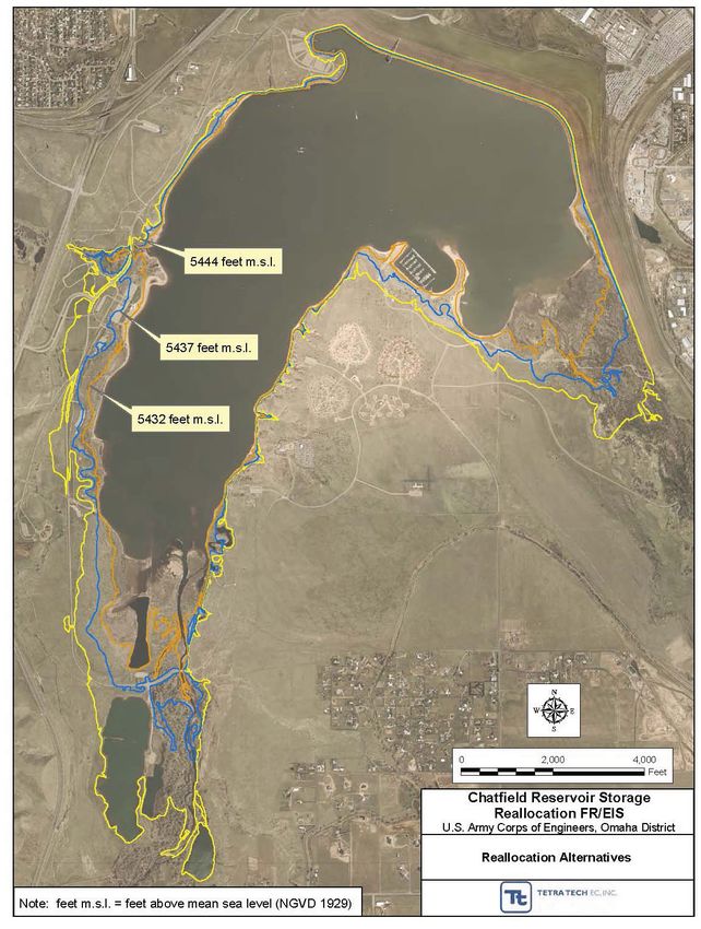
12feetofpotentialwaterlevelfluctuations(Figure3).Thefollowingmeasuresaddressimpacts
tofisheriesandaquatichabitat,wetlandandriparianhabitat,recreationandwildlifehabitat.
4.1ReservoirOperationsPlan
TheintentoftheReservoirOperationsPlanistoensureclosecommunicationsbetweenCPW
and the Project Participants regarding reservoir operations and to coordinate operations to
lessenimpactsfromtheProject.Theplanincludesspecificcommitmentsdesignedtominimize
thepotentialforadverseimpactsoncertainspecies,habitatandrecreation.
4.1.1General
Uncertainty: Reservoir operations are inherently uncertain due to a variety of factors
(fluctuating demands, change in water usage, randomness and high variability of natural
phenomena, climate change, extreme events, operational variability, and maintenance). The
purpose of the Reservoir Operations Plan is to attempt to lessen the uncertainty associated
withthesefactors.
YieldandUsefulnessoftheWaterfromuseofthestoragespace:Subjecttothecommitments
madeinsection4.1.3.3below,CPWwillnotseekanyoperationthatwouldresultinareduction
of the water right yield or significantly impair the usefulness of the storage space to each
ProjectParticipant.
OperationsPlanonlypertainstowaterstoredbytheProjectParticipants:Theprovisionsofthis
plan do not change the April 3, 1979 agreement between Denver Water and the State of
ColoradoDepartmentofNaturalResourcesrelatedtostorageinChatfield.
4.1.2Definitions:
Parties:CPWandtheProjectParticipants
Fluctuations:Waterbeingstoredandreleasedsoastocausethereservoirleveltogoupand
down.
18
GoodFaithEfforts:WherebyallPartiesworktogethertouseeconomicallyreasonablemethods
and means to achieve certain goals while maintaining a mutual understanding that in some
situations, such as drought, prolonged periods of below average water years, acts of God, or
othercircumstancesbeyondthecontroloftheChatfieldparticipants,thesegoalsmaynotbe
fullyattained.

4.1.3SpecificProvisions:

4.1.3.1Meetings

PartieswillmeetbimonthlyFebruarythroughOctoberofeachyeartosharetheirknowledge
ofcurrentconditionsanddiscussforecastsforfutureChatfieldoperations.

At the meetings, the Parties will review current conditions and forecasts; discuss operational
strategies and expected diversions into and deliveries from storage and include fish health
informationtoassistinprotectingfishandtheirhabitat.

Sources to be used for forecast information may include NOAA, National Weather Service
Climate Prediction Center, Colorado ClimateCenter Precipitation Monitoring, NRCS, the State
EngineersOffice,currentoperatingconditionsofeachparticipant,DenverWater,andothers,as
determinedbytheParties.

Theentitiesattendingthemeetings,thefrequencyanddatesofmeetingsmaybechangedby
mutualconsentoftheParties.

4.1.3.2.WaterStorage

ChatfieldReallocationProjectParticipantsmaystoreanylegallystorablewaterinChatfieldthey
areentitledtoatanytime.

4.1.3.3WaterReleases

     A. Ingeneral,ProjectParticipants,inconsultationwithCPW,willusegoodfaitheffortsto
         adjust the timing and amount of water releases from Chatfield so as to beneficially
         impact recreation and the environment.  Upon request of CPW, water releasesto the
         South Platte River from Participants’ storage accounts will be made through the
         Chatfield State Fish Unit, so long as the water released can be appropriately
         administeredbytheStateandDivisionEngineersandcreatesnoinjurytootherwater
         rights.CPWwillbesolelyresponsibleforreplacingintime,locationandamountanyout
         ofprioritydepletionscausedbytheProjectParticipants’waterbeingroutedthroughthe
         ChatfieldStateFishUnit.

     B. 1.       From March 1 to April 15, to avoid impacts to walleye spawning, Participants
         committolimitthedecreaseinthereservoirwaterlevelelevationfromtheParticipants’

                                                      19
storageaccountstonomorethan6”perday(whichisequivalenttonomorethan420
        cfsofoutflowinexcessofinflow).Theparticipantsdonotanticipatethat,undernormal
        circumstances,theirreleaseswillcausearapidlydecreasingpool.ThePartiesrecognize
        that the only time during the period from March 1 to April 15 that releases would be
        greaterthan6”perdayislikelyduringafloodeventorinanticipationofafloodevent.
        In such instances, Project Participants are not responsible for decreases in elevation
        greaterthan6”.Atalltimes,ProjectParticipantsareonlyresponsibleforreleasesthat
        occurasaresultoftheiruseoftheirstoredwater.

        2.        To avoid impacts on smallmouth bass spawning, Participants will consult with
        CPW on operational actions to minimize adverse impacts to smallmouth bass
        propagation.

    C. Participantswilllimitreleasesfromthereallocatedprojectstoragespace,asaccounted
       for by the Division of Water Resources and recorded on the Chatfield Storage
       AccountingSheet,suchthat:
       1.       BetweenMay1andJuly15,thewaterleveldeclineofthatspaceattributedto
       Participantreleasesisnotgreaterthan8,000AF;
       2.       BetweenJuly16andAugust31,thewaterleveldeclineattributedtoParticipant
       releaseswillnotexceed4,000AF;and,
       3.       DuringtheperiodofMay1toAugust31,thecollectivedailydischargefromthe
       reservoirfromtheChatfieldParticipantsshallnotexceed420cfsofoutflowinexcessof
       inflow.

       However,thecommitmentsundertheabovethreeprovisionsmaybesuspendedforthe
       remainderofacalendaryearifthefollowingtwoconditionsaremet:
       1.       At any time during the calendar year prior to August 31 the United States
       DroughtMonitorindicatesthata“severedrought”(alsoknownasaD2SevereDrought)
       existsforfourconsecutiveweeksanywherewithintheParticipantssourcewatersheds
       orserviceareas.
       2.       Participants who provide a municipal water supply impose some measure of
       wateringrestrictionsoncustomerswithintheirserviceareas.

       ItisexpectedthatthePartieswillusethebimonthlyoperationalmeetingsdescribedin
       Section4.1.3.1toforecastwhethertheaboveconditionsarelikelyoccurinagivenyear
       andusegoodfaitheffortstominimizeenvironmentalandrecreationalimpactsdueto
       thesuspensionoftheseoperationalcommitments.

    D. BetweenJuly15andthefollowingMay1,solongasParticipantswillnotloseyieldand
       are reasonably able to make use of a release of water from storage, Participants will
       make good faith efforts to work with CPW to time the releases out of Chatfield in a
       manner that would benefit the fishery and riparian environment downstream of
       Chatfielddam.


                                                      20
Thisplanmaybechangedfromtimetotimeonlybymutualagreementoftheparties.

4.1.4AdaptiveManagementforOperations
Adaptive management uses iterative decisionmaking to adjust compensatory mitigation to
meetthecoreobjectives.Resultsareevaluatedandfutureactionsareadjustedonthebasisof
whathasbeenlearned.BoththeFish,WildlifeandRecreationMitigationPlanandtheFR/EIS
recognizethatadjustmentsmayneedtobemadeasthemitigationactivitiesinthoseplansare
implemented.  The details of the adaptive management required by the USACE are in the
document entitled Adaptive Management Plan, which is Appendix GG of the FR/EIS. That
documentdescribesthecoreobjectives,uncertaintiesandcontingenciesforeachoftheareas
ofwaterquality,reservoiroperations,weedcontrol,treeclearing,aquaticlifeandfisheries,and
thesubjectoftheCMP,theTargetEnvironmentalResources.
In addition to unanticipated issues and challenges, the following are examples of what could
requireadjustmentsintheFish,WildlifeandRecreationMitigationPlanascurrentlyproposed:
    x   Allofthemitigationmeasuresmaynotbecompletelysuccessful;
    x   Somemitigationactivitiesmayprovidemorebenefitthancurrentlyestimated;
    x   Otheropportunitiesmaybecomeavailabletoprovidemitigation;and
    x   Natural disasters, such as forest fires or floods, could adversely affect mitigation
        activities.
Bytheirverynature,adaptivemanagementactionsareimplementedonan“asneeded”basis
and as informed by monitoring. The monitoring of impacts and mitigation will provide
important information and feedback for an iterative process of refining action to minimize
impacts and address uncertainties.  Annual monitoring reports will include information on
neededandproposedadjustmentsanduncertainties.Monitoringwillbeconcludedwhenallof
thecoremitigationobjectivesaremet,whichwillultimatelybedecidedbytheUSACE.

Thecoreobjectivesforoperationsare:

    1. Determineatargetelevationrangeandseasonalscheduleofstorageandreleasesthat
       wouldminimizeadverseeffectsonthetargetenvironmentalresourcesandrecreation;

    2. Determineoperationsthatcouldmeetthetargetelevationandseasonalscheduleof
       storageandreleasesona“besteffort”basiswithoutadverselyaffectingtheyieldofthe
       ChatfieldWaterProvidersasidentifiedinthisreallocationproject;

    3. Annuallymonitortheeffectsofstorageinthereallocatedspaceonthetarget
       environmentalresources;

    4. Continuetoexplorewaystoadjustoperationsascircumstancesallowminimizing
       adverseeffectsonthetargetenvironmentalresourcesandrecreation;and

                                                   21
You can also read