Boundary Amendment Application - Annapolis, London Town & South County Heritage Area, Inc. April 2021
←
→
Page content transcription
If your browser does not render page correctly, please read the page content below
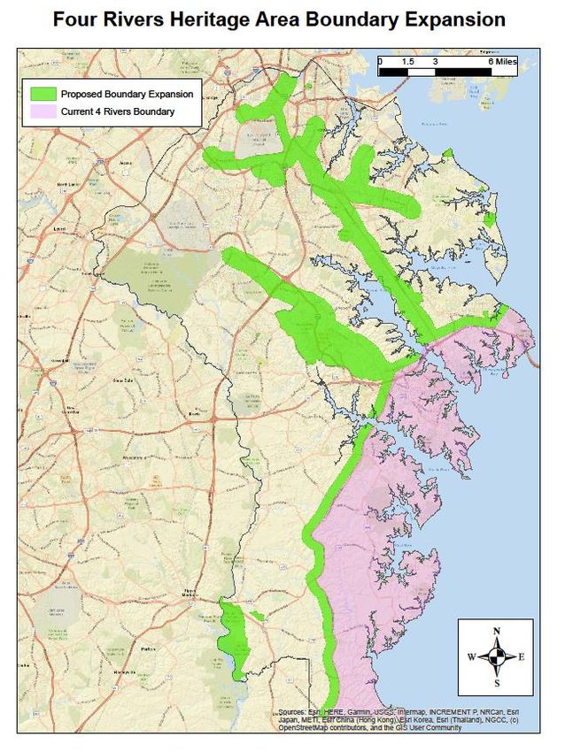
Boundary Amendment Application

    Annapolis, London Town & South County Heritage Area, Inc.
                                              April 2021

                          Detail, Vintage Postcard, West Street in Annapolis

FOUR RIVERS HERITAGE AREA, 44 CALVERT STREET, ANNAPOLIS, MD 21401 – 410-222-1805 – HERITAGE_AREA@AACOUNTY.ORG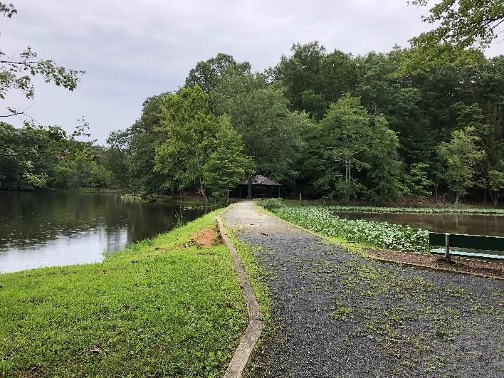
Boundary Amendment Application
                                April 2021
         Annapolis, London Town & South County Heritage Area, Inc.
              (ALTSCHA, Inc.), dba Four Rivers Heritage Area

     The Mission of the Four Rivers Heritage Area is to advance, support, and promote the natural,
                             historic, and cultural resources of the region.

 Designated as a Certified Heritage Area (CHA) in 2001, the Annapolis, London Town & South County Heritage Area,
 Inc. (dba Four Rivers: The Heritage Area of Annapolis, London Town & South County or “Four Rivers Heritage
 Area”) stretches from Sandy Point State Park at the Chesapeake Bay Bridge, extending through southern Anne
 Arundel County, to Rose Haven at the Calvert County line, encompassing the Severn, South, Rhode, and West
 Rivers.

 From 18th-century buildings, both grand and modest, in the National Historic District of downtown Annapolis, to
 swaths of pristine landscapes and maritime communities, the Four Rivers Heritage area strives to honor the stories
 of those who have called it home for centuries. Southern Anne Arundel County heritage tells the story of
 generations of farmers and watermen whose lives have been shaped by the Chesapeake Bay and the rich farmland
 that surrounds it.

 As home to hundreds of cultural, natural, and historical resources, the Four Rivers Heritage Area plays an integral
 role in building capacity and connecting the sites together. The creative synergy in its collaborative approach helps
 to lift up the historic preservation and the organizational insights of professional museum directors. The Four
 Rivers Heritage area provides opportunities for peer-to-peer interactions and trainings, best practices in upgrading
 facilities to accessibility standards, and grant-writing training and support needed to access funds, helping partners
 to attract dollars from state and federal government and foundations.

 The present-day interconnectivity between sites operating at different levels would likely never have been realized
 if not for the Four Rivers Heritage Area, whose multi-faceted operation creates a strong and unique heritage
 community. The collective goal — to lift up the stories, buildings and places, cultural landscapes, traditions, and
 quality of life, to last and sustain for years to come — is a powerful model for visitors and residents alike. Source:
 “Four Rivers Heritage Area Makes an Impact,” Parker Phillips, Commissioned by the Maryland Heritage Areas
 Authority, December 2020

Section 1 – Introduction and Process

1.1 -- ALTSCHA: Background

ALTSCHA became fully certified in October 2001, after a process summarized in the Management Plan Summary (pp. i-
iii.) MHAA guidance to the original Steering Committee had recommended that the heritage area contain the highest
concentration of heritage-related sites and resources in Anne Arundel County, and so, in addition to including Annapolis,
Historic London Town, and Sandy Point State Park, the boundary was drawn to include more of the rural area of
                                                                                                                          2
southern Anne Arundel County. It was hoped that inclusion of this portion of the county would allow for the
interpretation and protection of its rural and scenic character. Although other areas of the county were considered for
inclusion, the Steering Committee followed early MHAA advice to focus on a fairly compact area, which in ALTSCHA’s
case was bounded by major routes: Routes 301/50 between the Chesapeake Bay Bridge and Annapolis, and the
southern portion (the area below Route 50) of Maryland Route 2, also known as Solomons Island Road. Thus, the MHAA-
approved boundary included the waterfront maritime communities of Edgewater, Galesville, Shady Side, and Deale. The
boundary line was defined down the middle of Route 2; properties on the east side of this rural state route were within
the boundary, and those on the west side were outside of it.

As other Certified Heritage Areas (CHA’s) amended their boundaries over the past decade, and organizations outside
CHA boundaries in Anne Arundel County sought to access the benefits available through MHAA and from Four Rivers
itself, there were calls from these heritage organizations to be included in the heritage area. During years when a
boundary amendment was being contemplated but not yet pursued, the Executive Director, Carol Benson, developed a
non-comprehensive list of county sites outside the heritage area that were labeled “significant,” as a first step. The goal
was to acknowledge sites’ cultural and historical standing, in a respectful and inclusive way, prior to the expected
forthcoming phase of work that would assess their potential for heritage tourism, a prerequisite for the MHAA grant
program. To create this list, she consulted colleagues in the field who were active in the county. These included Patricia
Barland, Janice Hayes-Williams, Jane Cox, and colleagues at the Northern Arundel Cultural Preservation Society (NACPS),
who included Betty Mack, Lynda Davis, Lily Caldwell, Tony Spencer, and Yolanda Dickerson. After removing from the list
those sites that were no longer preserved (a location that might be called “formerly the site of…” in a survey or on a
historic marker), Benson attached the list as an Appendix to the Annual Plan submitted that year: “Appendix D,” or
“Attachment to Annual Plan, FY2017 Appendix D: Preliminary, Non-Comprehensive List of Significant Resources in Anne
Arundel County (Sites not in the heritage area that are significant/contributing to our county heritage)” (March 2016).
The list was refined and updated the following year, again as an Appendix to the Annual Plan.

As the organization developed its vision for a future amendment of its boundary, it was planned to be based on a
county-wide review by an outside party, unlike other boundary amendments sought previously by other CHA’s. The goal
was to work as equitably as possible with all heritage-related sites and organizations affected, regardless of previous
familiarity or relationship. It was the Board’s hope to work with Anne Arundel County’s Office of Planning & Zoning
Cultural Resource Division (CRD) if at all possible, as this Division is itself county-wide, works diligently with heritage
resources specifically, and has also been the funding “home” for the County’s portion of ALTSCHA’s local government
support. This Division contains the institutional knowledge to list and review the relevant sites, make recommendations,
and provide important background for a project of this nature.

In late 2018, ALTSCHA’s Board made the decision to go forward with a boundary amendment. A subcommittee of the
Board met to define an RFP with criteria and a scope of work, which was completed in January 2019. In addition to a
county-wide review, tasks would include assessment of areas and sites, a recommendations list, and materials to be
used in support of a potential boundary amendment application. The Board encouraged CRD to seek funding for their
work from MHAA as a grant application project in partnership with ALTSCHA. The CRD team applied to MHAA for a
FY2020 MHAA Non-Capital Grant, for a project entitled “Boundary Amendment Study for ALTSCHA,” requesting $50,000,
and in July 2019, the grant was awarded.

1.2 -- CRD’s Process, “Boundary Amendment Study for ALTSCHA” Project

The CRD team included staff members Jane Cox (Chief of Cultural Resources), Darian Beverungen (Historic Preservation
Planner), Anastasia Poulos (Archaeological Sites Planner), and consultant Jason Vaughan. The project extended from
August 2019 to September 2020. The team’s process included the following activities completed for the project:

                                                                                                                          3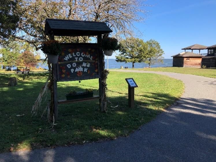
1. INITIAL RESEARCH PHASE (Aug –Oct 2019)
     - Materials provided by Four Rivers, including approximately 160 sites listed as part of “Appendix D”
     - Research and interviews on original boundary
     - Expansion of list to approximately 300 assets including MIHP sites, known archaeological sites, historic
         churches and cemeteries county Rec and parks sites
     - Consideration of current Four Rivers major interpretive themes and the potential of additional themes
2. STAKEHOLDER ENGAGEMENT AND PUBLIC OUTREACH (Nov 2019 – May 2020)
     - Public Stakeholder Meeting on December 11, 2019, including:
             o Goals of the boundary amendment project
             o Discussion of current and potential themes
             o Discussion of underserved communities
             o Polling attendees on most significant sites and assets and potential for heritage tourism
     - Meeting with Anne Arundel Parks and Recreation staff
     - Site visits (Note: Due to limitations of the COVID-19 pandemic, the majority of these did not take place in-
         person, but instead a questionnaire was sent to site managers, followed by a phone conversation. The results
         are listed in Appendix D of the EBFRHA Report.)
3. EVALUATION AND MAPPING OF SITES (May 2020 – Aug 2020)
     - Definition of several parameters for evaluation
             o Heritage tourism potential
             o Functional use, e.g., Museums, performing arts venues, churches, parks, etc.
             o Primary heritage sites, private heritage assets, natural assets, community institutions
             o Non-extant or insufficient information available
     - Creation of Documentation and short narratives for each asset for inclusion in report
     - Definition of highest potential sites resulting in approximately 90 sites for further review and documentation
     - Mapping and definition geographic considerations
             o Concentration of assets (“heat mapping”) and potential for clustering of sites
             o Consideration of point sites and spokes
             o Definition of geographic location clusters
                       ▪ North County (8 assets)
                       ▪ Glen Burnie and Marley Neck Peninsula (9 assets)
                       ▪ Pasadena, Mountain Road Corridor, and Hog’s Neck Peninsula (15 assets)
                       ▪ Broadneck, Arnold, and Severna Park (7 assets)
                       ▪ Crownsville and Annapolis Vicinity (11 assets)
                       ▪ Odenton, Gambrills, Millersville (13 assets)
                       ▪ West County (10 assets)
                       ▪ Davidsonville and Crofton Area (7 assets)
                       ▪ Jug Bay, Lothian, and the Patuxent River (9 assets)
     - Additional analysis and development of Focus Areas, e.g., Railroad history and conversion to trails, The
         African American Experiences, Native American Heritage along the Patuxent River.
4. RECOMMENDATION OF FOUR BOUNDARY AMENDMENT ALTERNATIVES (Jul –Aug 2020) [EBFRHA p. 101]
     - ALTERNATIVE 1
             o High-value mature sites with existing or imminently
pending visitor access and experiences
     - ALTERNATIVE 2
             o Assets in Alternative 1, combined with high potential sites that need higher level of support or
                  cultivation
     - ALTERNATIVE 2A
             o Alternative 2 sites with a one-quarter-mile buffer
     - ALTERNATIVE 3

                                                                                                                        4
o  Assets in Alternatives 1 and 2 with additional connectivity between routes and trails, auxiliary
                recreational assets, and a small buffer of inclusion around all sites
     - ALTERNATIVE 3A
            o Alternative 3 sites with a one-quarter-mile buffer
     - ALTERNATIVE 4
            o No significant action; add one-half-mile buffer to existing heritage area boundary
 5. REPORT PREPARATION (Jul – Aug 2020)
     - Evaluation summaries, asset descriptions, narratives, maps and spatial deliverables
     - Recommended Management actions
     - Technical Considerations, e.g., inclusion in the General Development Plan and Comprehensive Plan
 6. DELIVERY AND FINAL REVIEWS WITH ABAP COMMITTEE AND FOUR RIVERS BOARD (Aug - Sept 2020) -- Final Report,
 “Expanding the Boundaries of the Four Rivers Heritage Area” (EBFRHA), August 2020; Review by ABAP Committee and
 Board, September 2020. Amendments to GIS-Based Interactive Map,

1.3 --   ABAP (ALTSCHA Boundary Amendment Project) Committee and Process
Once the CRD team’s report (EBFRHA) was received, the ALTSCHA’s Board formed a Committee for the ALTSCHA
Boundary Amendment Project, or ABAP for short, to undertake the review of the report, carefully consider the areas and
sites involved, and make a determination of final boundary recommendations to the Board. The ABAP Committee
members were Tim Leahy, Barbara Polito, Gertrude Makell, Linnell Bowen, Lily Openshaw, Marcie Taylor-Thoma, and
Hope Stewart, and it was staffed by Carol Benson. Tim, Barbara, Gertrude, Linnell, and Lily are members of ALTSCHA’s
Board of Directors; Marcie serves on the Coordinating Council and was a former member of MHAA’s Technical Advisory
Committee (TAC); Hope is a part-time staff member; and Carol is Executive Director. The Committee’s process, which
ran from August 2020 through the finalization of this application document in March 2021, included the following
activities:

 Perform extensive analysis of the County team deliverables including the report (with static maps), exhibits and
 spreadsheets
 Review asset descriptions in EBFRHA Appendix C to become familiar with each, and share knowledge of sites
 from previous visits
 Identify and consider appropriate assets not included on list
 Visit sites (grounds and exteriors only, due to COVID-19) throughout the County
 Meet with County mapping team (Jane Cox and Stacey Poulos) to review asset spreadsheets, GIS methods and
 ongoing use of County staff to update the interactive maps
 Review each asset in spreadsheet and assess for conformance with key criterion of heritage tourism potential
 Assessment of “OOC” (Out of Consideration) and possible “Phase 2” (Revisit in 5 years) assets
 ABAP Boundary Amendment recommendations formulated and refined
 Final ABAP recommendations hand-drawn on County map, presented to full Board
 Map and map narrative shared with CRD to revise GIS-based interactive map
 Prepare materials for Boundary Amendment application

The process was organic; the ABAP Committee met every two weeks without predetermined expectations. The
Committee members reviewed maps and lists of sites, shared their collective knowledge of the sites considered by CRD,
and then turned to visiting sites on their own, often capturing photographs of the sites, and then discussing their
experiences in the meetings. The goal was to have at least one Committee member visit the full list of sites that had
been identified as Primary Assets by CRD in the EBFRHA Report and described in “Appendix C, Resource Descriptions.”
The decision to start the process with experiencing the sites first-hand, supplemented by the information in the
Resource Descriptions, served as the foundation for the Committee’s work. Committee discussions focused on
                                                                                                                    5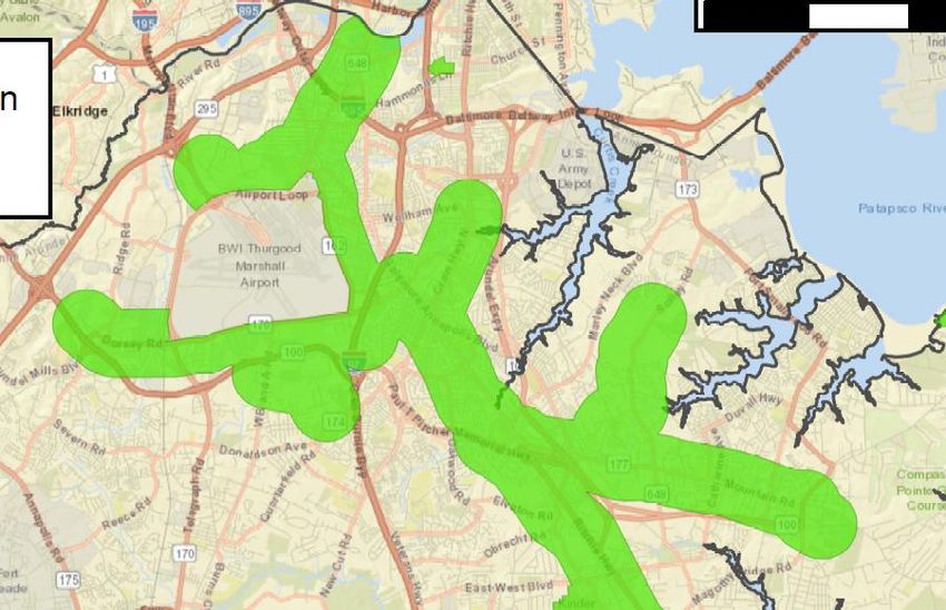
identifying sites and areas with “heritage tourism potential.” This term is subjective rather than objective, so
conversation and debate helped to hone the Committee’s views on this criterion over time.

As reflected in the EBFRHA Report, ALTSCHA’s Board had        African American Heritage -- African American heritage
begun the process with several clear directives. The first    in North County has largely been lost. North County’s
was to add a half-mile buffer to the existing boundary.       contemporary landscape of commercial corridors and
The second was to address the inclusion of more diverse       dense residential development can mask — but does not
stories, especially the African American and Native           hide — its connections to historic communities of color
American heritage stories that were not fully addressed       established in the mid-1800s before the Civil War and
in our documents or the original boundary. The                emancipation. Connecting the communities were
approaches taken by the ABAP Committee differed for           influential churches, which served not only spiritual
these two categories of stories: a focus on African           needs, but also social needs. The Black churches “were
American heritage was added with a specific trail route       significant as social centers, cultural conduits, school
through North County communities (the North County            sponsors, and havens for political expression.” Some
African American Heritage Trail), although there are          North County farmland owned and worked by African
other sites that relate to this theme as well. Native         Americans was subsumed into BWI Thurgood Marshall
American resources were reviewed on a case-by-case            International Airport and highway thoroughfares such as
basis, and were primarily addressed through the sites in      I-695 and I-97. (Source: EBFRHA)
the “Jug Bay Cluster” in the southwest corner, although
there are others noted.

A different aspect that was not a priority for the ALTSCHA Board or ABAP Committee until the COVID experiences of
2020 was an emphasis on recreational trails, which came to the forefront when our County parks and trails were
inundated with visitors wanting to get out and exercise in the fresh air during the pandemic. The Committee now viewed
the transformation of the County’s extensive railroad heritage into Rail-to-Trail recreational bike paths in an entirely
new and favorable light. In the Boundary Amendment proposal, the trails have an added half-mile buffer on either side,
which incorporates the heritage-related resources that grew up along the railroad lines in the communities they served.

Finally, with so many individual sites to consider for their heritage tourism value or potential, the Committee noted sites
that become the two Clusters (discussed in section 2), and added twelve additional sites meriting inclusion, identified for
their already-established heritage tourism visitation.

1.4 -- Final Boundary Recommendation:
The final Boundary areas proposed for addition fall into five categories:

                o   Half-mile buffer to existing boundary
                o   North County African American Trail, consisting of a route through communities, with a half-mile
                    buffer on either side of route, from Pumphrey to Harmans
                o   Two Clusters: Mid-County Cluster (Crownsville, Bacon Ridge, Annapolis Waterworks Park, and
                    environs), and Jug Bay Cluster (six related parcels)
                o   Two Recreational Trails (Rail-to-Trail bike paths with extensive railroad heritage), with half-mile
                    buffer on either side of trails, and a third smaller trail, located in North County, the “BWI Trail.”
                o   Sites with current heritage tourism visitation, contiguous to a buffer or a standalone parcel:
                        ▪ Chesapeake Arts Center
                        ▪ Kinder Farm Park
                        ▪ Fort Smallwood Park
                        ▪ Downs Park
                        ▪ Hancock’s Resolution
                        ▪ Goshen Farm
                                                                                                                            6
▪   National Electronics Museum
                        ▪   National Cryptological Museum
                        ▪   Whites Hall
                        ▪   Linthicum Walks
                        ▪   Annearrundell County Free School Museum
                        ▪   Anne Arundel Community College

1.5 -- Acknowledgements: The Board of Directors of ALTSCHA, Inc., would like to acknowledge the work of a large
number of contributing individuals, including Executive Director Carol Benson, the members of the ABAP Committee
(Tim Leahy, Barbara Polito, Gertrude Makell, Linnell Bowen, Lily Openshaw, Marcie Taylor-Thoma, and Hope Stewart),
the CRD team (Jane Cox, Darian Beverungen, Anastasia Poulos, and contractor Jason Vaughan), members of the Anne
Arundel County Department of Planning and Zoning who advised and reviewed the CRD in their work, and the MHAA
staff, particularly Jennifer Ruffner. Additional assistance came from the Northern Arundel Cultural Preservation Society
(NACPS), including Betty Mack, Lynda Davis, Lily Caldwell, Tony Spencer, and Yolanda Dickerson. These NACPS members
advised an earlier stage of the project, and also shared the details of their copyrighted tour. Additional assistance was
provided by Tony Spencer, who clarified the location, significance, and condition of several key assets. Others who have
contributed input include Patricia Barland and Janice Hayes-Williams. Board Chair Tim Leahy performed multiple roles in
overseeing the project, visiting nearly every site under consideration, and developing a hand-drawn map and narrative
that informed the determination of the GIS-based interactive map.

                                                                                                                        7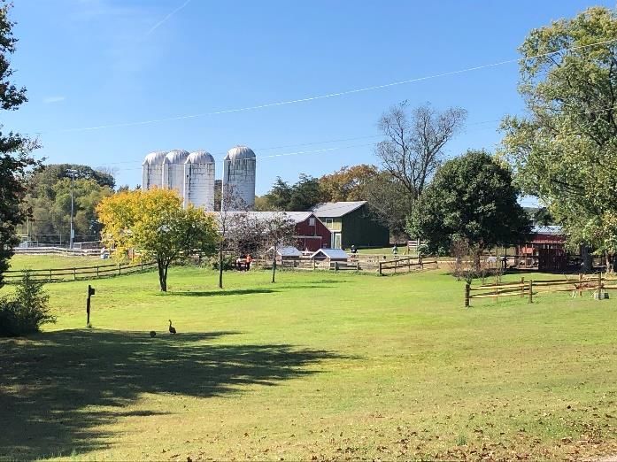
Section 2 – Boundary Amendment Proposed Areas (with
Significant Resources)

This application seeks to amend the existing ALTSCHA Boundary with new areas in five
categories:
    •   Half-mile buffer along existing boundary
    •   North County African American Trail, consisting of a route through communities, with a half-mile buffer on
        either side of route, from Pumphrey to Harmans
    •   Two Clusters: Mid-County Cluster (Crownsville Hospital and Cemetery, Bacon Ridge Natural Area, Annapolis
        Waterworks Park, and environs), and Jug Bay Cluster (six related parcels considered limited-use parks)
    •   Two Recreational Trails (Rail-Trail bike paths with extensive railroad heritage), with half-mile buffer on either
        side of trails, with a third minor trail (BWI Trail)
    •   Sites with current heritage tourism visitation, contiguous to a buffer or a standalone parcel

2.1 -- Half-mile buffer along original boundary
The half-mile buffer along the existing boundary will correct disparities such as the separation of the parcels on the west
side of Route 2 in South County (not in the original heritage area) from the east side (included), and add other nearby
neighbors who have worked with ALTSCHA in recent years. Heritage-related sites in this buffer include Asbury
Broadneck United Methodist Church in Broadneck, All Hallows Episcopal Church (also known as the Brick Church) in
Edgewater, and “ag-tourism” farms such as Obligation Farm in Harwood. Goshen Farm is adjacent to the buffer.

2.2 -- North County African American Trail, consisting of a route through
communities, with a half-mile buffer on either side of the route, from Pumphrey to
Harmans.
This Trail is based on a heritage-related bus tour developed by the Northern Arundel Cultural Preservation Society
(NACPS), entitled “The Northern Arundel Cultural Preservation Society (NACPS) presents a Historical and Educational
Tour of African American Enclaves and Sites in Northern Anne Arundel County.” The non-profit organization was
founded in 2005 to collect, document, preserve, and share the contributions of African Americans in the history and
culture of Northern Anne Arundel County and Maryland. The tour was made possible by a grant from the Arts Council of
Anne Arundel County (ACAAC) and Community Foundation of Anne Arundel County (CFAAC). The tour followed a route
through seven North County communities. Commencing in Pumphrey, on Belle Grove Road, the next stop was Furnace
Branch, located on Crain Highway and Furnace Branch Road. The third “stop” was Freetown, on Freetown Road,
followed by Marley Neck, located on Solley Road. The fifth “stop” was the community of Magothy/Pasadena, located
on Artic Drive. This was the furthermost stop to the east; the tour now headed west, to Queenstown, located on

                                                                                                                            8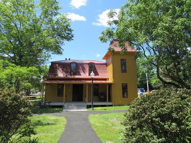
Spotlight On: NORTH COUNTY AND THE AFRICAN AMERICAN EXPERIENCE

 North County’s contemporary landscape of commercial corridors and dense residential development can mask —
 but does not hide -- its connections to historic communities of color established in the mid-1800s before the Civil
 War and emancipation. The names of these African American communities are still with us today: Freetown, Dorsey,
 Queenstown, Marley Neck, Pumphrey, Furnace Branch. The contributions of Blacks to the Anne Arundel County’s
 development cannot be understated. These communities farmed the land and sold their produce across the region
 and built and served on the railroads that tied Washington, Annapolis, and Baltimore. Farmland owned and worked
 by African Americans would become the state’s largest airport: BWI Thurgood Marshal International. Connecting the
 communities were influential churches, which served not only spiritual needs, but also social needs.
 As early as the 1840s, free Blacks began acquiring property in what is now considered northern Anne Arundel
 County. These purchases were often aided by former slave owners as well as the pro-abolitionist Quaker community.
 Acquiring land and building communities “became the key to freedom within the oppressive circumstances of the
 time.” Farming was the primary enterprise of the communities, although iron mining, construction, and working in
 local grain mills provided additional employment opportunities.
       The Freetown/Marley Neck area is one of the earliest founded communities and became of the largest
 communities of color outside of the Annapolis vicinity. One of the first community buildings erected by former
 enslaved people and their descendants was a church built on land donated by Black landowner John Hall in the
 1880s. Although this original structure no longer stands, today the site is home to Hall United Methodist Church. The
 church’s cemetery dates to its founding in the late-nineteenth century. Also on the site is a stone altar that once
 served an earlier “bush church,” an open-air space for religious services. Adjacent to the church is a Rosenwald
 School built in 1927 to provide a primary school education for Black children in the segregated county school system.
       The African American communities were also connected via rail lines that crossed the region. Communities of
 color developed around station stops, including Dorsey, Queenstown, Waterbury, Harman, and Severn. The
 Baltimore and Annapolis Short Line, which began operations in 1887, included the first stop in a primarily African
 American community: Pumphrey at the very northern edge of Anne Arundel County. Not only did the railroads
 provide transportation, but also provided opportunities for work, such as porters, track inspectors, and warehouse
 workers and foremen. Perhaps the region’s most visible connection to the past is the network of religious
 institutions which trace their lineage to the founding of the earliest communities of free Blacks. The congregations of
 Mount Zion, Hall, John Wesley, and St. John United Methodist church all trace their history back to the 1850s,
 making them the oldest African American congregations in northern Anne Arundel County. As communities of color
 grew across the region, new religious institutions formed across the region in Hanover, Pumphrey, Odenton, and
 Queenstown. These churches continue to connect communities, families, and spirits. Despite modern development
 in North County, the legacy of entrepreneurship, determination, and faith of these communities is still very much
 present today.

Queenstown Road, and ended in Harmans/Dorsey, located on Dorsey Road. ABAP Committee members drove the tour
route to experience the local communities, and decided to adapt it into a North County African American Trail that
follows the tour’s route, with a half-mile buffer on each side to encompass the communities that the tour was designed
to highlight.
Heritage sites found in the communities along the Trail include various sites in the Pumphrey Community such as St.
John United Methodist Church; the John Wesley United Methodist Church in Furnace Branch; the Freetown Historic
District in Freetown and a marker for the former Rosenwald School at the site; the Marley Neck Rosenwald School, Hall
United Methodist Church and a “stone altar” on the site in Marley Neck; the Mt. Zion United Church and former
Magothy Rosenwald School in Magothy/Pasadena: the Queenstown Park, former Queenstown Rosenwald School, and

                                                                                                                           9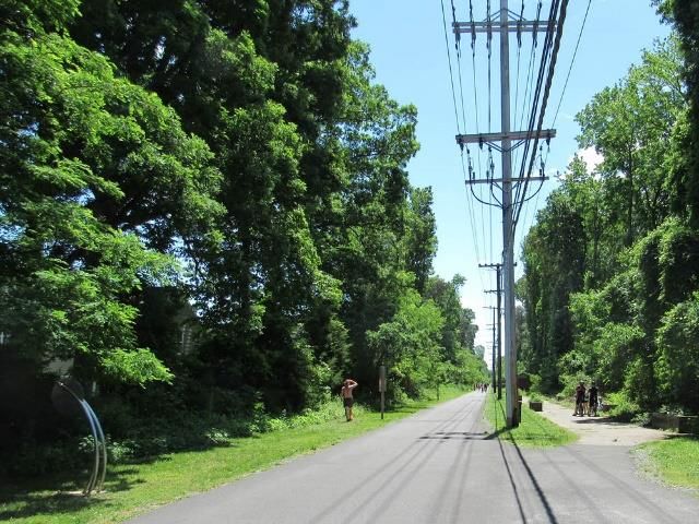
Metropolitan United Methodist Church in Queenstown; and the Mt. Pilgrim Baptist Church and a marker for the former
Harmans Rosenwald School in Harmans.

2.3 -- Two Clusters: Mid-County Cluster (Crownsville, Bacon Ridge, Annapolis
Waterworks Park, and environs), and Jug Bay Cluster (six related parcels of
protected land)
Mid-County Cluster – This area is located in the middle of the county, including portions of the historic Generals
Highway. This Cluster contains hundreds of acres of park land; it is
possible that the steep terrain accounts for the lack of development
here, allowing for large natural areas running from north to south, from
Bacon Ridge in the north to the Annapolis Waterworks Park in the
south. The largest and most notable parcels within this Cluster include
Crownsville State Hospital and Cemetery, Bacon Ridge Natural Area
(1,100 acres), Generals Highway Corridor Park (100 acres), and
Waterworks Park, a 600-acre recreational area that surrounds what was
once Annapolis’s water reservoir system.

The Jug Bay Cluster is a collection of seven protected wetland sites at
the southern end of the Patuxent’s run through Anne Arundel County.           Waterworks Park (Annapolis Waterworks
The county-owned sites are managed by the Department of Recreation Company)
and Parks and are supported by more than 600 volunteers from the
non-profit Friends of Jug Bay. The complex sites protect 1,700 acres of unique tidal freshwater marshes, forested
wetlands, upland and riparian forest, creeks, meadows, pine and sand barrens, and fields along the Patuxent. This
protected land provides a safe haven for a high diversity of plants, insects, mammals, amphibians, reptiles, birds, fish
and microbes. The richness of flora and fauna in this area has attracted foragers, hunters, and settlers over the past
13,000 years. The Mattapanian Indians were the last native people to live at Jug Bay and abandoned their land in the
mid-1600s due to increased pressures from English settlement along the Patuxent. Significant Native American
archaeological resources have been located within the sanctuary; there are more than 60 recorded archaeological sites
and more are found each year. The sites are the subject of robust research and public programming in coordination with
the county’s Cultural Resources Division and in partnership with the non-profit Lost Towns Project. Considered limited-
use parks, there are an array of amenities in six units of the complex, including natural trails, fishing piers, boat launches,
picnic areas, and restrooms. The seven parcels are: Patuxent Wetlands Park, Nature Preserve at Wayson's Corner,
Glendening Nature Preserve, Jug Bay Wetlands Sanctuary, Jug Bay Farm Preserve and Shepherd Property.

2.4 -- Recreational Trails: Two Rail-to-Trail bike paths with extensive railroad
heritage (B&A Trail and South Shore Trail), with half-mile buffer on either side of
trails, with third minor trail (BWI Trail)

The addition of these trails is an acknowledgment of the county’s commitment to the development of its recreational
trail network, which is directly tied to the history of railroad development in the county from 1833 through 1950, now
seen through the lens of the thousands of county residents who, during the COVID-19 crisis, turned to parks and

                                                                                                                            10
recreational trails for a safe way to exercise and get fresh air outside of their homes. The trails are accompanied by half-
mile buffers on each side, incorporating the heritage resources here that grew up along the railroad lines.
Spotlight On: RAILROAD HERITAGE
In 1827, the Maryland General Assembly granted a charter for the construction and operation of the national’s first
commercial railroad: the Baltimore and Ohio. The initial success of the B&O spurred the development of railroads
across the state. With its proximity to Baltimore and Washington, D.C. — as well as the home of the state capital —
Anne Arundel County saw tremendous railroad development from the 1830s through the first decade of the 1900s.
A decade after greenlighting the B&O Railroad, the general assembly chartered the optimistically named Annapolis
and Elkridge Railroad (A&ERR) to connect the capital with Elkridge in what is now Howard County. When completed
on Christmas Day in 1940, the western terminus was not Elkridge but “Annapolis Junction” where the A&ERR
connected to the B&O’s Washington- Baltimore line near Savage, Maryland. (The B&O’s rail line is still in service
today operating under the ownership of CSX with MARC Camden Line service.) The Maryland General Assembly
granted a charter in 1853 to the Baltimore and Potomac Railroad to build a rail line connecting Maryland’s economic
hub to the Potomac River south of Washington. The Civil War caused massive disruptions to the line’s construction
and the unbuilt railroad was purchased by the Pennsylvania Railroad in 1867. Pennsylvania Railroad service between
Washington and Baltimore started in 1872. The junction of the Pennsylvania Line and Annapolis and Elkridge
Railroad was named Odenton in honor of Oden Bowie. Bowie was the president of the original company wishing to
build the line (as well as a member of the Maryland House of Delegates and a one-term governor). This rail line is
still in operation as part of Amtrak’s Northeast Corridor with MARC Penn Line service. The Annapolis and Elkridge
Railroad was not immune to the turmoil of the Civil War.
Commandeered by the Union Army, years of wartime use had a detrimental effect on its tracks, locomotives, and
railcars. The railroad was sold at foreclosure in 1886 and reincorporated as the Annapolis, Washington and
Baltimore Railroad. In 1887, the B&A Short Line Railroad began service connecting the state’s political and economic
hubs. This steam-powered service ran from Annapolis northwest to a junction with the B&O Railroad near Westport
in south Baltimore. In the first decade of the 1900s, dramatic new change came to railroads in Anne Arundel County.
In 1908, the WB&A Electric Railway began providing passengers interurban service connecting Washington,
Baltimore, and Annapolis. The WB&A’s main north-south line ran parallel and slightly east of the Pennsylvania
Railroad’s main line. To provide service to Annapolis, the WB&A purchased what was once the Annapolis and
Elkridge Railroad and electrified the route. The intersection of these lines was dubbed “Naval Academy Junction,”
located in Odenton a short distance from the Pennsylvania Railroad station.
In 1921, the WB&A purchased the B&A Short Line, which had conveniently switched from steam to electric power in
1908. Now three lines formed the WB&A: the main line from Washington to Baltimore, the South Shore Line (the old
A&ERR), and the North Shore Line (former Short Line) running from Annapolis’s Bladen Street terminal to the main
line junction near Linthicum. Like many companies, the WB&A was not immune to the financial turmoil of the Great
Depression. The company was put on the auction block in 1935. Other factors were at play: between 1900 and 1920,
the number of automobile registrations in Maryland jumped from 8,000 to 8,000,000. The North Shore Line was
salvaged and continued operating as the Baltimore and Annapolis Railroad until 1950 for passenger service. Freight
service ended in 1968. The fate of WB&A’s main line and South Shore Line was much starker: everything associated
with these lines were sold for scrap to the Boston Iron and Metal Company for $252,150. (Source: EBFRHA)
The B&A Trail and its half-mile buffer: The Baltimore & Annapolis Trail is a 13.3-mile rail trail. The trail runs north-south
through communities whose growth and development were intricately tied to the original 1887 steam railroad and its
11electric successor which operated from 1908 to 1968. From Dorsey Road near Baltimore Light Rail's Cromwell Station in
Glen Burnie, the trail runs through Pasadena, Severna Park, and Arnold. The southern terminus is located just north of
Route 50 (Boulters Way). An on-road bike lane connects the southern terminus to the county’s Jonas and Anne
Catharine Green Park. The trail is managed by the Anne Arundel County Department of Recreation and Parks with
volunteer support from the non-profit Friends
of Anne Arundel County Trails. It opened on Spotlight: ALONG THE SOUTH SHORE TRAIL
Oct 7, 1990 as the second rail trail in
Maryland. In June 1996, the Baltimore & In the nineteenth century, western Anne Arundel County began a
Annapolis Trail became part of the East Coast transformation spurred by the establishment of railroads. The
Greenway, from Calais, Maine to Key West, railroads not only connected Annapolis, Baltimore, and Washington,
Florida. The trail is part of the American D.C., but also connected county farmers to these significant
Discovery Trail–a trail from the Atlantic coast metropolitan markets. From the mid-nineteenth century through
of Delaware to San Francisco, California. This the 1930s, truck farming was the major industry of Anne Arundel
trail and its half-mile buffer include Earleigh County, with more than 4,000 truck farms at the turn of the
Heights Station, Severna Park Station, and twentieth century. The presence of the railroads encouraged
B&A Electrical Station, and is adjacent to additional development in the area, and in the early twentieth
Kinder Farm Park and Anne Arundel century, this western area of the county was again transformed by
Community College. The restored Earleigh the establishment of Fort George G. Meade and the U.S. Naval
Heights Railroad Station houses the trail Academy Dairy Farm.
ranger’s station and a small railroad museum.
The history of the unincorporated town of Odenton is tied directly
The South Shore Trail is a 11.2-mile long, to the development of railroads in Anne Arundel County, most
planned shared-use rail trail that will run from notably the 1840 Annapolis and Elkridge Railroad, 1872
Annapolis to Odenton in Maryland, United Pennsylvania Railroad, and the 1908 Washington, Baltimore and
States. Two segments totaling 2.96 miles have Annapolis Electric Railroad (WB&A). Much of Odenton’s remaining
been built. The Trail primarily utilizes the historic fabric is located in close proximity to the Odenton MARC
abandoned roadbed of the Annapolis and Elk Station (AA-2105), which was built around 1945 to serve the
Ridge Railroad. The planned trail starts in Pennsylvania Railroad, and the crossroads of two WB&A lines. The
Odenton and travels southeast through the non-profit Odenton Heritage Society (OHS) is a steward of three
communities of Gambrills, Millersville, and historic properties located near the MARC station. The Old Masonic
Crownsville. This trail route and its half-mile Hall at 1367 Odenton Road serves as the OHS Historical Center. The
buffer includes the sites contained within the second floor of the 1912 frame structure houses exhibits and
Odenton Historic District, the Childs displays on Odenton’s history and is open to the public one Sunday
Residence (South Shore Trail Headquarters), a month; the ground floor is used as a meeting space. Behind the
and portions of Generals Highway, along Masonic hall is the OHS-owned Old Bethel Church, a small
which the Rising Sun Inn and Belvoir (Scott’s rusticated concrete block structure built in 1922. OHS also owns the
Plantation) are situated. The trail is managed Citizen’s State Bank building, which is adjacent to the MARC
by the county’s department of parks and station. Built in 1917, the bank building now houses a coffee shop
recreation; the trail’s headquarters are popular with train commuters. Close by is Epiphany Episcopalian
located at the Child’s Residence, the 1840s Church, built in 1918. It is the only known World War I chapel in the
house of Millersville’s first postmaster. The United States. The chapel and house were listed in the National
trail will connect with the Colonial Annapolis Register of Historic Places in 2001. (Source: EBFRHA)
Maritime Trail on the east and the
Washington, Baltimore and Annapolis Trail, via the Odenton Bike Path, on the west. When complete, it will be a
component of the American Discovery Trail, the East Coast Greenway and the September 11th National Memorial Trail.
The South Shore Trail's multi-phase construction will consist of the following -- Phase I: Waterbury Road to MD Route 3
(1.97 miles); Phase II: MD Route 3 to Odenton (2.07 miles); Phase III: Bestgate Road to Eisenhower Golf Course (2.59
12miles); Phase IV: Eisenhower Golf Course to Waterbury Road (3.55 miles); Phase V: Bestgate Road to City of Annapolis
(3.37 miles).
The BWI Trail (also managed by the Anne Arundel County Department of Recreation and Parks) circles BWI Airport, and
the section of the trail proposed for the Boundary Amendment runs between Benson-Hammond House and the
National Electronics Museum.
2.5 -- Sites with current heritage tourism visitation, contiguous to a buffer or a
standalone parcel
The addition of these sites with current heritage tourism visitation seemed imperative to the ABAP Committee. Many,
but not all, of these sites were included by CRD team in the EBFRHA report. The list contains three of Anne Arundel
County’s Regional Parks (the fourth, Quiet Waters Park, is already in the heritage area); two national museums in North
County; the Chesapeake Arts Center; and small heritage sites that regularly
open to the public for events. In addition, Anne Arundel Community
College has partnered with ALTSCHA in the past, and we anticipate future
collaborations and partnerships, for example for heritage-related events.
For Resource Descriptions, see Section 5.
▪ Chesapeake Arts Center (standalone parcel)
▪ Kinder Farm Park (contiguous to B&A Trail
buffer)
▪ Fort Smallwood Park (standalone parcel)
▪ Downs Park (standalone parcel)
▪ Hancock’s Resolution (standalone parcel)
▪ Goshen Farm (contiguous to original boundary Chesapeake Arts Center
buffer)
▪ National Electronics Museum (contiguous to BWI Trail section)
▪ National Cryptological Museum (standalone parcel)
▪ Whites Hall (standalone parcel)
▪ Linthicum Walks (standalone parcel)
▪ Annearrundell County Free School Museum (standalone parcel)
▪ Anne Arundel Community College (contiguous to B&A Trail buffer)
13Section 3 -- Boundary Amendment Narrative Description
Note: If boundary is defined as a trail or road, the actual boundary will extend ½ mile on each side of the trail
or road.
North County/Glen Burnie/ Marley Neck/Pasadena/Hog Neck
DESCRIPTION
Chesapeake Arts Center Parcel (Standalone parcel)
Ft. Smallwood Park Parcel (Standalone parcel)
Hancock’s Resolution Parcel (Standalone parcel)
Downs Park Parcel (Standalone parcel)
BWI TRAIL
Pumphrey Recreation Center on Belle Grove Rd, W and S ½ Mi on Belle Grove Rd
(MD 170) to N. Camp Meade Rd. ½ mi on N. Camp Meade Rd (MD 170) To W. Maple
Ave. ¼ mi west to trailhead of BWI Trail.
BWI Trail to S. Hammonds Ferry BWI Trail to Andover Rd, then NW on Andover Rd to
National Electronics Museum
BWI Trail (along Aviation Blvd) S with Bump out for Benson-Hammond grounds (see
below), Continue around BWI Trail to Dorsey Rd
Benson-Hammond grounds (from lease): Beginning for the same at point in the
southerly right-of-way line of Aviation Boulevard, said point being located 74.83 feet
right of station 236+ 85.09 of the baseline of construction and right-of-way of said
road and as shown on Maryland State Highway Administration Plats Number 51290
and Number 52438 ; thence departing said point so fixed and binding on said
southerly right-of-way line in part thereof with meridian reference to Maryland State
Grid North, NAD-27,
1) South 67 ° 36' 29" East 207.25 feet; thence
2) South 53° 00' 47" East 24.05 feet; thence
3) South 49° 21' 11" East 134.96 feet; thence
4) South 22° 12' 33" East 63.50 feet; thence
5) South 20° 29' 02" East 135.62 feet; thence
6) South 07 ° 01' 37" East 52.85 feet; thence
7) South 04° 56' 48" East 124.86 feet; thence departing said right-of-way so as
to cross and include a portion of the land of the Maryland Aviation Administration,
8) North 62 ° 26' 12" West 564.38 feet; thence
9) North 19° 10' 49" East 299.49 feet to the point and place of beginning
Containing 142,448.77 square feet or 3.2702 acres of land more or less.
Being a portion of the land of the Maryland Aviation Administration as recorded
among the Land Records of Anne Arundel County, Maryland in Liber 2508 at Folio
252.
West on Dorsey Rd, including only the south side, to Aviation Blvd. Then north and
south sides of Dorsey road to MHT Marker
At intersection of Dorsey Rd. and WB&A Blvd, south on WB&A Blvd to Queenstown
Rd to Queenstown Community Center parcel
14BWI Trail at Friendship Park South on John Overstreet Connector trail to North
terminus of B&A trail
B&A TRAIL
South on B&A Trail (adjacent to B&A Blvd) to Crain highway Glen Burnie
Intersection of B&A trail and Crain highway North on Crain Highway to John Wesley
Parcel
South on B&A Trail (adjacent to Richie Highway) to Intersection of B&A trail and
Mountain Road. East on Mountain Rd to Freetown Road. North on Freetown Rd to
Solley Rd. North on Solley Rd to Hall
Intersection Of Freetown Rd and Mountain Rd to Artic Rd, Pasadena
Broadneck/ Arnold/Severna Park
DESCRIPTION
Intersection of Mountain Rd and BWI Trail South (adjacent to Richie Highway) to
East West Blvd, bump out to include Kinder Park Parcel, South to College Parkway to
Include AACC parcel, then south to the current Four Rivers boundary
North of Rt 50 at Cape St Claire Rd to include Goshen Farm parcel
Annapolis/Crownsville cluster plus selected Standalone parcels
DESCRIPTION
From South shore of the Severn River, along new half-mile buffer of existing
boundary to Generals Highway.
5.5 miles to intersection of Generals Highway and Waterbury Road, with bump out
to include Belvoir parcel. West on Waterbury Rd to Severn Chapel Rd. Severn
Chapel Rd to St. Stephens Church Rd. (South side only). South on St. Stephens
Church Rd (East side only) to Chesterfield Rd. (East side only). Chesterfield Rd. east
to Defense Highway (North side only). Defense Highway to Generals Highway (North
side only).
Whites Hall parcel (standalone parcel)
Linthicum Walks parcel (standalone parcel)
Annearundell Free School parcel (standalone parcel)
New half-mile buffer - South from Rt 50 on Rt to along current Boundary
West County /Odenton / Gambrills/ Millersville
DESCRIPTION
Intersection of Waterbury Rd and South Shore Trail (proposed). South Shore Trail
(along Millersville Rd to Annapolis Rd to Odenton Rd). 4.4 miles to Odenton Historic
District. Include Epiphany Church Parcel.
Cryptology Museum (standalone parcel)
15Jug Bay Complex
DESCRIPTION
Patuxent Wetlands parcel to Glendening Nature Preserve parcel to Jug Bay Wetlands
Parcel, with standalone Shepherd parcel
16Section 4 -- Interpretive Themes
4.1 -- Interpretive Themes from ALTSCHA Management Plan
The three major Interpretive Themes in ALTSCHA’s Management Plan (2000) were Waterways, Living with the Past, and
America’s Roots. Below, the summaries of these themes and their subthemes are listed, with selected “key resources.”
Waterways – “Throughout its history, the Annapolis, London Town, and South County Heritage Area has been shaped by
its relationship to the Chesapeake Bay and its tidal tributaries, including the Severn (a state-designated “Scenic River”),
South, and West Rivers. Waterways is a term that embraces the region's geography and ecology, its maritime traditions
and recreational sailing, its settlement patterns (including those of Native Americans), water-related crafts and
traditions, commerce (including the tobacco economy), consumption, and communication on local, regional, national,
and global scales. Sites from the Barge House Museum in Eastport to Herrington Harbor (including several County parks)
are encompassed within this theme. It speaks to one of the area's most obvious and pervasive attributes – extended
shoreline and water views – while embracing the full sweep of regional history as experienced by all kinds of people,
black and white and red.”
Subthemes:
• The Ecology of the Water’s Edge. Key resources: Chesapeake Bay Foundation, Annapolis Recreation and Parks,
SERC, Historic London Town and Gardens, City Dock in downtown Annapolis
• Waterborne Commerce and Communication. Key resources: The Annapolis Historic District, Captain Avery
Museum, Galesville, Deale, Shady Side, Eastport, Historic Annapolis, Historic London Town and Gardens
• Commerce to Recreation. Key resources: Galesville, Highland Beach, Bay Ridge, Annapolis Harbor, Eastport,
Shady Side, Sandy Point State Park, Annapolis Maritime Museum, Deale
• Life on the Water. Key resources: The Naval Academy (guided tours, Visitor’s Center, Museum), Maryland State
Archives, City Dock, Historic Annapolis, Captain Avery Museum, Galesville, AAACCVB Visitor’s Center, Deale,
Shady Side
Living with the Past – “The heritage area is a living landscape, neither fixed in time or meaning. The story of how the
presence of the past informs life in the present engages some key ideas, i.e.:
o History is a dynamic relationship between past and present (expressed in sites throughout the heritage area).
o The relationship between people and place is continuously evolving.
o There are many ways to recover, restore, preserve, and celebrate the past.
o Scenes of historical significance, such as the Maryland State House, are still important today.
The theme of living with the past invites area residents as well as tourists and school children to see history as an open-
ended story in which people make history and in which many diverse experiences and viewpoints are at play.”
Subthemes:
• Living Landmarks. Key resources: Historic Annapolis, historic churches within the heritage area, Maryland State
House, Historic London Town and Gardens, Hammond-Harwood House, Chase-Lloyd House, Naval Academy,
Maryland State Archives
• Preserving the Past. Key resources: the Wilson House restoration in Galesville, ongoing archaeological digs and
archives, Captain Avery Museum, Charles Carroll House, Historic Annapolis, Hammond-Harwood House, Historic
London Town and Gardens
17• The Re-Usable Past. Key resources: Banneker-Douglass Museum, Historic Annapolis, various properties in
Eastport
• Artists, Architects, and Artisans. Key resources: Annapolis City Plan, Historic Annapolis (William Paca House),
Charles Carroll House, Chase-Lloyd House, Historic London Town and Gardens (William Brown House), National
Register properties in the heritage area, Hammond-Harwood House, Naval Academy, Maryland State House
America’s Roots – “The heritage area is, in many ways, a model on which America as a nation has been patterned. From
its early colonization the region was committed to a market economy, to global commerce, and to individual enterprise.
For European settlers the area was an open society in which individuals could accumulate resources, rise in status, and
attain prominence based on merit and achievement, exemplified, for example, in the four major historic house museums
in Annapolis and in numerous National Register properties throughout the County. For African-Americans, the region is a
case study in adaptation, survival, and cultural resilience as indicated in the Frederick Douglass House, the Maynard-
Burgess House, and the Banneker-Douglass Museum. This theme also embraces the important state and national events
associated with the American Revolution, the Civil War, and other key events. Most important, the overall theme helps
visitors and residents to explore what was distinct and significant about the regional experience, to discover how it was
different from other areas, and to understand how the region has changed over time.”
Subthemes:
• A Revolutionary Time. Key resources: Charles Carroll House, Chase-Lloyd House, Hammond Harwood House,
Maryland State Archives, Maryland State House, Historic Annapolis (William Paca House), St. John’s College
• War and Peace. Key resources: Maryland State Archives, Maryland State House, Naval Academy, Galesville,
Deale, Eastport (WWII history)
• African Americans in Anne Arundel. Key resources: African American Heritage in Annapolis, Annapolis Historic
District, Asbury Methodist Church, Banneker-Douglass Museum, Galesville, Historic Annapolis, Charles Carroll
House, Hammond-Harwood House, Highland Beach, Kunta Kinte - Alex Haley Memorial Site at City Dock,
Maryland State Archives, Maryland State House, Naval Academy
4.2 -- Suggested New Interpretive Themes Related to Boundary Amendment
The new areas that are part of the Boundary Amendment are related to these themes:
➢ Rail-to-Trail Recreation: Both a land-based version (as opposed to the Waterways theme) of Commerce to
Recreation, and also The Re-Usable Past fit the Rail-to-Trail Recreational Trails of the Boundary Amendment. It
should be noted that recreational bike trails were specifically called out in the Summary of the original Management
Plan of 2000: “Bicycle Improvements: As the only location where two national trail systems – the East Coast
Greenway from Maine to Florida and the American Discovery Trail from California to Delaware – will intersect, the
Annapolis, London Town, and South County Heritage Area offers great potential for bicycling to be part of the
heritage tourism experience. The highest priority bicycle improvement is to establish continuous on-street bike lanes
from the Severn River Bridge to the new Visitors Center. (Bike lanes are currently in place that connect the heavily
used Baltimore and Annapolis Hiking and Biking Trail with the Severn River Bridge.) In addition, planning for roadway
improvements to Rowe Boulevard should incorporate bike paths as part of a strategy of developing an area-wide
bicycle network. Map/guide information regarding bicycle touring should be developed for distribution at the Visitors
Center as the bicycle “hub” of the heritage area.” [Summary, p. vi; note that the “New Visitors Center” was never
pursued, due to opposition from the Annapolis City Council. Also, Action Plan, 4.1.4, “Moving About the Heritage
Area.”]
➢ Native American Heritage: While Native American heritage was mentioned only in passing in the Management Plan
(2000), probably from a motivation to protect that heritage, it has been the intention of ALTSCHA’s Board of
18Directors for several years to correct what now seems like an insulting omission. A new interpretive theme that is
inclusive of this important part of this area’s past is a priority, and this will be restated in ALTSCHA’s forthcoming
Five-Year Plan. The Jug Bay Wetlands Sanctuary Complex is an ideal place to share the Native American story with
heritage visitors, as it is now recognized as a highly significant and rare archaeological asset. Within a surprisingly
small area, there are deeply stratified and relatively untouched archaeological sites representing 12,000 years of
human occupation. Dozens of unique archaeological sites have been recorded and studied in the sanctuary and its
partner properties, including the Glendening Nature Preserve and the Nature Preserve at Wayson’s Corner. These
sites have yielded stone tools, decorative pottery, finely honed projectile points, and evidence of subsistence, trade,
and even ancient social structures. The study of these sites provides a small but highly significant window into the
rich Native American presence that dominated this area for millennia before Europeans arrived. While providing an
important part of the Native American narrative, sites along the Patuxent River need to be understood in
relationship to other Native American sites across the county. The densely packed heritage sites in and around Jug
Bay, and along the Patuxent River, provide exciting potential for visitors, students, and citizens to explore the legacy
and places where Native Americans lived for some 12,000 years. In cooperation with Jug Bay Wetlands Sanctuary
staff, there are several well-established public-private partnerships with the County’s Cultural Resources Division,
the non-profit Lost Towns Project, and most recently, with Washington College. Sites such as the Benson-Hammond
House and Kuethe Library offer additional public venues for interpretation and exhibition of prehistoric artifacts,
adding another means by which visitors can engage with Anne Arundel County’s Native American heritage [Source:
EBFRHA].
A selected list of sites related to Native American Heritage includes:
• Bacon Ridge Natural Area
• Benson-Hammond House
• Fort Smallwood Park
• Glendening Nature Preserve -- Dorr Prehistoric Site, Plummer Farm Complex
• Hancock’s Resolution
• Jug Bay Wetlands Sanctuary
• Kinder Farm Park
• Kuethe Library
• Nature Preserve at Wayson’s Corner
• Patuxent Wetlands Park
• Pig Point Archaeological Site
• Jug Bay Farm Preserve (Riggleman Farm)
• Waterworks Park
➢ Natural Resource Experiences – Four Rivers Heritage Area defines “heritage” as historical, cultural, and natural
resources. This theme has come to be even more important in recent years, and especially now that the burden of
living with COVID-19 has driven many people to seek outdoor experiences.
This larger theme is consistent with ALTSCHA’s original interpretive themes
of The Ecology of the Water’s Edge and Life on the Water. A selected list of
sites related to Natural Resource Experiences includes:
• Jug Bay Cluster (All)
• Mid-County Cluster (All)
Left: Nature Preserve at
• B&A Trail
Wayson’s Corner (Jug Bay
• Downs Park
Cluster)
19You can also read