Granite Mountain IHC Entrapment and Burnover Investigation - Yarnell Hill Fire - June 30, 2013 Arizona Division of Occupational Safety and Health
←
→
Page content transcription
If your browser does not render page correctly, please read the page content below
Granite Mountain IHC
Entrapment and Burnover Investigation
               Yarnell Hill Fire – June 30, 2013

                         Prepared for:

      Arizona Division of Occupational Safety and Health

                         Prepared by:

                   Wildland Fire Associates
                       November, 2013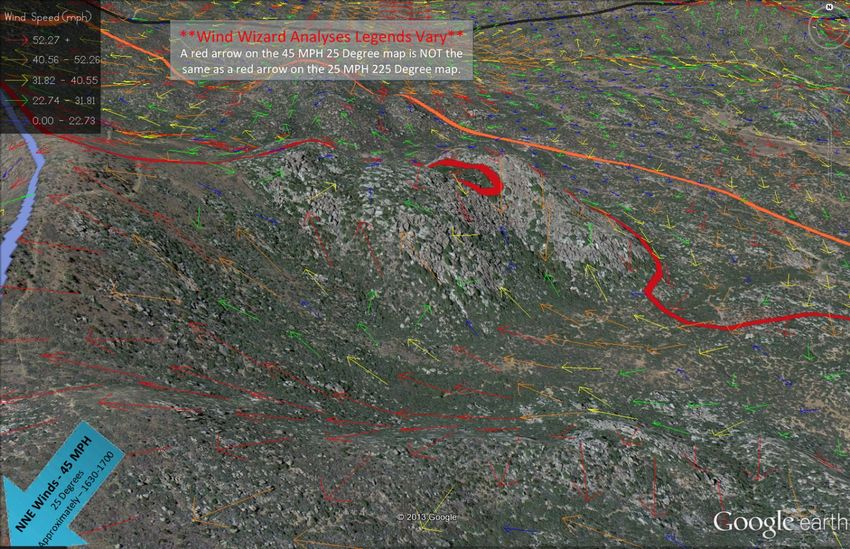
Granite Mountain IHC
                                                   Entrapment and Burnover Investigation | 2

CONTENTS

ACRONYMS                                                                               3

INTRODUCTION                                                                           5

TIMELINE                                                                               6

FIRE BEHAVIOR AND FIRE WEATHER SUMMARY                                                17

 Fire Environment                                                                     17

 Fuel/Vegetation Conditions                                                           18

 Fire Weather                                                                         19

 Fire Behavior                                                                        21

DISCUSSION                                                                            29

 Arizona State Forestry Division                                                      30

 Yarnell Hill Fire Incident Management                                                31

 Departure from Standard Practices                                                    39

 Fatigue                                                                              42

CONCLUSIONS                                                                           43

APPENDIX A – Curricula Vitae                                                          44

APPENDIX B – Fire Behavior and Weather Supporting Graphics                            46

APPENDIX C – Glossary                                                                 57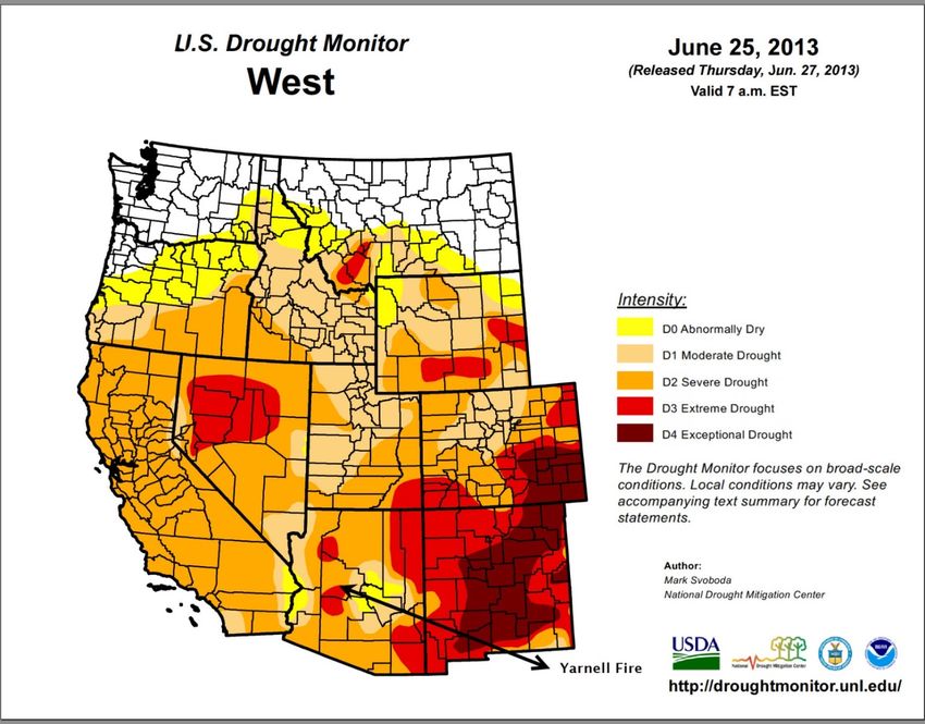
Granite Mountain IHC
                                                         Entrapment and Burnover Investigation | 3

ACRONYMS
ACRONYM    DESCRIPTION
-A-
A/G        Air to Ground
ADC        Arizona Dispatch Center
ADOSH      Arizona Division of Occupational Safety and Health
AFMO       Assistant Fire Management Office
AOBD       Air Operations Branch Director
ASFD       Arizona State Forestry Division
ASM        Aerial Supervision Module
ATGS       Air Tactical Group Supervisor
- BC -
BCMG       Base Camp Manager
BLM        Bureau of Land Management
BRIHC      Blue Ridge Interagency Hotshot Crew (Hotshots)
C&G        Command and General (Staff)
COML       Communications Unit Leader
- DEF -
DIVS       Division Supervisor
DOC        Department of Corrections
FBAN       Fire Behavior Analyst
FMO        Fire Management Officer
FSC        Finance Section Chief
- GH -
GIS        Geographic Information System
GM         Granite Mountain Hotshots
GMIHC      Granite Mountain Interagency Hotshot Crew (Hotshots)
HEQB       Heavy Equipment Boss
-I-
IA         Initial Attack/Incident Action
IAP        Incident Action Plan
ICT1       Incident Commander Type 1
ICT2       Incident Commander Type 2
ICT3       Incident Commander Type 3
ICT4       Incident Commander Type 4
ICP        Incident Command Post
IHC        Interagency Hotshot Crew (Hotshots)
IMT        Incident Management Team
IMT2       Incident Management Team, Type 2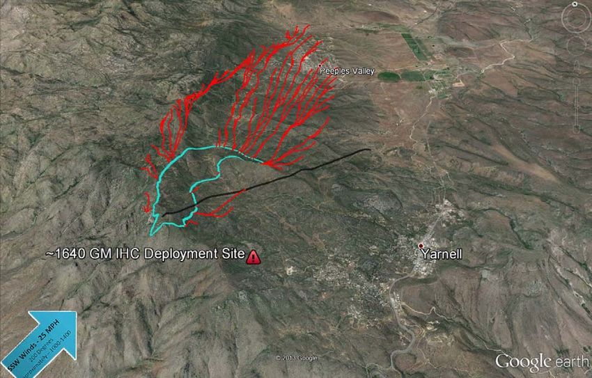
Granite Mountain IHC
                                                        Entrapment and Burnover Investigation | 4

ACRONYM     DESCRIPTION
- JKLMN -
LAT         Large Air Tanker
LCES        Lookouts Communication Escape Routes and Safety Zones
LSC         Logistics Section Chief
NCDC        National Climatic Data Center
NOAA        National Oceanic and Atmospheric Administration
NWCG        National Wildfire Coordinating Group
NWS         National Weather Service
- OPQR -
OSC         Operations Section Chief
ORDM        Ordering Manager
PSC         Planning Section Chief
RH          Relative Humidity
ROS         Rate of Spread
ROSS        Resource Ordering Status System
-S-
SAIT        Serious Accident Investigation Team
SEAT        Single Engine Air Tanker
SOF         Safety Officer
SPGS1       Structure Protection Group 1 Supervisor
SPGS2       Structure Protection Group 2 Supervisor
SPUL        Supply Unit Leader
STPS        Structure Protection Specialist
SWCC
-T-
TAC1        Tactical Frequency 1
TAC3        Tactical Frequency 3
TIME        Time Unit Leader
- UWXYZ -
UTV         Utility Terrain Vehicle
WFA         Wildland Fire Associates
WFDSS       Wildfire Decision Support System
WFSA        Wildland Fire Situation Analysis
VLAT        DC-10 Very Large Air Tanker
YFD         Yarnell (Volunteer) Fire Department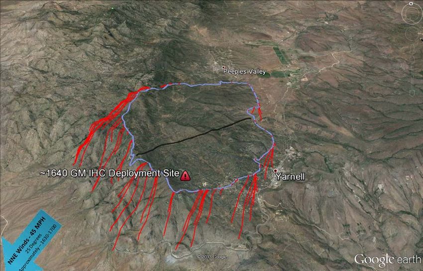
Granite Mountain IHC
Entrapment and Burnover Investigation | 5
INTRODUCTION
On June 30, 2013, 19 members of the Granite Mountain Interagency Hotshot Crew died after being
entrapped and burned over on the Yarnell Hill Fire in Yarnell, Arizona. The purpose of this document is
to provide:
A TIMELINE OF EVENTS THAT OCCURRED BETWEEN THE TIME OF IGNITION ON JUNE 28
AND THE ENTRAPMENT AND BURNOVER ON JUNE 30;
AN ANALYSIS OF THE FIRE BEHAVIOR AND FIRE WEATHER ON JUNE 30;
A DISCUSSION OF OVERHEAD MANAGEMENT, STRATEGIES AND TACTICS USED ON THE
FIRE, AND DOCUMENTATION OF DECISION POINTS LEADING UP TO THE ENTRAPMENT
AND BURNOVER THAT CLAIMED THE LIVES OF THE FIREFIGHTERS.
This document was prepared by Wildland Fire Associates (WFA) under contract with Arizona Division
of Occupational Safety and Health (ADOSH). Wildland Fire Associates participated in the investigation
by ADOSH that included visits to the deployment site, interviews, reviews of incident documents
including weather maps and data, and communication logs and field notes.
During this investigation, we looked at all phases and aspects of the Yarnell Hill Fire that we thought
were relevant. In doing so, we made numerous requests for data and information pertinent to this
incident. Through ADOSH, we were given access to all information and personnel that we requested
with the exception of the employees of the USDA Forest Service. The USDA Forest Service declined
the request to allow their employees to be interviewed for this investigation.
WILDLAND FIRE ASSOCIATES
Wildland Fire Associates is a private company staffed with career wildland fire managers who are
highly trained and have many years of experience from initial attack and hotshots through Type 1
Incident Command and Area Command. The five-member team that reviewed incident documents,
conducted interviews and wrote this report are:
DAN O’BRIEN, TEAM LEADER
ELIZABETH ANDERSON, DEPUTY TEAM LEADER
BARRY HICKS, ANALYSIS OF FIRE OPERATIONS & AVIATION
DAVE LARSEN, ANALYSIS OF FIRE OPERATIONS & OVERHEAD TEAM
DARRELL SCHULTE, FIRE BEHAVIOR ANALYST
Curricula vitae are located in Appendix A.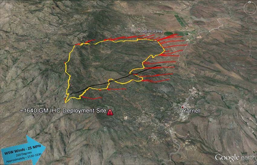
Granite Mountain IHC
                                                                  Entrapment and Burnover Investigation | 6

TIMELINE
This timeline includes details from the 2013 Arizona Fire Season Outlook, as well as events as they
occurred on the Yarnell Hill Fire from ignition to the time of the entrapment and burnover.

PRE 2013 FIRE SEASON ACTIVITIES
On March 28, 2013, the Arizona Fire Season Outlook was released by the Arizona State Forestry
Division (ASFD). The area of Yavapai County that includes Yarnell was listed as having high fire
potential due to low live fuel moistures, and the county as a whole was predicted to see a moderate
increase in fire potential compared to the 2012 fire season:

“The chaparral vegetation type on State lands around Prescott, Yarnell, Mayer, and Bagdad is
expected to have a below average live fuel moisture that will lead to high fire potential. Many of the
chaparral stands are older with a high dead/live ratio that may prove resistant to control efforts due to
the low live fuel moistures. Seasonal new fine fuel growth has been delayed due to the dry winter & late
seasonal moisture.”

“Temperatures and ground moistures have not started the green up/growth of seasonal grasses. Grass
loading is expected to be average in the perennial grasslands areas in the 3000 to 5000 foot elevations
near Cordes Junction, Mayer, Prescott Valley, Chino Valley, Verde Valley, and Peeples Valley. Fire
potential is predicted to be moderate to high in these areas.1”

YARNELL HILL FIRE TIMELINE NARRATIVE

June 28, 2013

On June 28 at approximately 1700 hours, the Yarnell Hill Fire was started by a lightning strike. The
initial report was made to the Arizona Dispatch Center (ADC) at approximately 1740 by the volunteer
fire department in Congress, Arizona (10 miles southwest of Yarnell, Arizona).

An ASFD Assistant Fire Management Officer (AFMO), who is also a qualified Incident Commander
Type 3 (ICT3), traveled to Yarnell to be closer to the location of multiple new fire starts that resulted
from the lightning activity.

Land jurisdiction in the Yarnell area includes private land, Arizona State Lands Department (for which
Arizona State Forestry has fire suppression responsibilities) and Bureau of Land Management (BLM).
The AFMO met with the BLM Fuels Specialist to coordinate actions on fires on either jurisdiction.

The Air Tactical Group Supervisor (ATGS) for the Doce Fire was requested to fly over the area to size-
up the Yarnell Hill Fire and look for any more fires started by lightning. The ATGS stated that the
Yarnell Hill Fire was in a boulder field with no vehicle access. The initial assessment was that the fire
was less than a half-acre, only active in one corner and did not pose a threat to structures or people.
Based upon the initial assessment, the inaccessibility of the fire and concerns about being able to
adequately support firefighters overnight, the AFMO, who had become the initial attack Incident
Commander (ICT4) at approximately 1940, decided to delay initial attack of the fire until the following
1
    2013 Arizona Fire Season Outlook, Arizona State Forestry Division, March 28, 2013. page 10.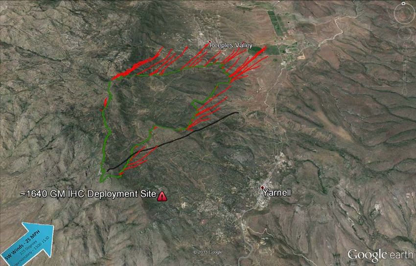
Granite Mountain IHC
                                                                    Entrapment and Burnover Investigation | 7

morning. The ICT4 planned for suppression activities the following morning and ordered two Arizona
Department of Corrections (DOC) crews, a Type 6 engine and a Type 3 helicopter.

The strategy for the fire was full suppression. The tactic for the next day was to use a helicopter to
transport people to and from the fire. A spot weather forecast was received at 2207.

June 29, 2013

At 0651, the ICT4 requested that the Single Engine Air Tanker Base at Wickenberg Airport be opened
so that two Single Engine Air Tankers (SEATs) could be used. The plan was to use fire retardant on the
north and south sides of the fire, but leave the west and east flanks open. There was a two-track road
on the east side of the fire.

In the morning, a BLM Representative took a flight to update the status of the fire. The Yarnell Hill Fire
was estimated to be approximately eight acres with little fire activity. From this assessment, the ICT4
and BLM Representative jointly developed an initial attack plan to put six firefighters from the DOC
Lewis Crew and one helitack crewmember on the fire using the helicopter for transportation. ICT4 also
planned to remove the firefighters from the fire by 1530 due to lightning risk from afternoon storms.

                                                           At 1011, ICT4 requested a helicopter to shuttle
                                                           crews.

                                                           The SEATs arrived mid-morning and dropped fire
                                                           retardant on the flanks of the fire, each SEAT
                                                           making two retardant drops to hold the fire
                                                           perimeter.

                                                           At 1100, a BLM helicopter transported seven
                                                           firefighters to the top of the ridge. The one helitack
                                                           and six DOC Lewis Crew firefighters hiked in the
                                                           rest of the way into the fire.

                                                       At approximately 1225, the ICT4 reported the fire
 Figure 1. Photo taken by a Granite Mountain Interagency
 Hotshot Crew (GMIHC) member on two-track road early onsize was about two acres. The ATGS reported that
 June 30, 2013 during test-fire operations.
                                                       the fire retardant had secured the south and west
flanks, and indicated that a ridge flanked the fire to the north and that a two-track road secured the
eastern flank.

At 1442, the ICT4 released the ATGS and the SEATs because the fire was holding on all four sides and
no other fires ignited the previous day were still burning. The original plan by ICT4 was to fly crews
down off the fire by 1530.

At 1500, a weather alert for thunderstorms was issued by the National Weather Service (NWS).
However, the storms dissipated prior to reaching the Yarnell Hill Fire.

At 1540, the ICT4 released the BLM brush engine and a local Peeples Valley fire engine that were
being held in the event any new fires from the lightning on June 28 appeared.
Granite Mountain IHC
                                                              Entrapment and Burnover Investigation | 8

During the afternoon, the temperature reached a high of 116°F (recorded in Phoenix, Arizona).

At 1600, weather conditions were hot and dry. Winds from the west-southwest increased which led to
increased fire activity.

At 1610, the ICT4 requested two SEATs and the ATGS to return to the Yarnell Hill Fire. The ADC sent
one SEAT but held the second aircraft so that it could be available for the Dean Peak Fire.

About 1630, the Yarnell Hill Fire jumped the two-track road on
the east side of the fire, despite lack of winds associated with
thunderstorm activity. ICT4 indicated to ADC that there were
concerns about containment, and at 1655 ordered a Type 1
                                                                        “Not everyone agreed with the
Heavy Helitanker and a Large Airtanker (LAT).
                                                                        selected strategy and tactics.
At 1730, 13 firefighters were assigned to contain the fire that         We were not gonna put it out
had jumped the two-track road. The Yarnell Hill Fire was                with aircraft. Apparently they had
estimated at six acres. At some point near this time, the ICT4          tried aircraft on Saturday. That
                                                                        didn’t hold.” ~ ADOSH interview
learned that the DOC Lewis Crew was out of chainsaw gas
                                                                        with SPGS2
which seriously hindered their effectiveness in chaparral.

Near the time the fire jumped the two-track road, approximately
1730, the BLM representative who was a qualified ICT3 made
an inquiry to the ICT4 whether the ICT4 wanted the BLM
representative to “take over the fire.” The ICT4 declined the offer.

At 1742, additional requested air resources declined dispatch due to high winds and severe weather
between their home base and the fire location. The ICT4 continued to use SEATs to drop fire retardant
on the Yarnell Hill Fire.

Soon after 1743, dispatch offered a Very Large Air Tanker (VLAT) from Albuquerque in place of a
heavy air tanker that could not respond due to weather. Based on discussion with ATGS and the local
BLM representative, the ICT4 declined the VLAT offer.

Between 1730 and 1924, the fire behavior and complexity continued to escalate. Based upon his
interview and dispatch logs, ICT4 communicated a request to ADC for an Incident Commander Type 3
(ICT3), and then changed it to a State of Arizona Incident Management Team (IMT2) with the intention
of having them take over the fire on June 30. ICT4 voiced concerns about potential threats to Peeples
Valley and Yarnell, Arizona, in the following 24 to 48 hours. In addition, two structure group specialists
were requested (one for the north end of the fire at Model Creek and Peeples Valley, and one for the
south end of the fire at Yarnell and Glen Ilah). The ICT4 also requested three Interagency Hotshot
Crews (IHC). Three IHCs were assigned to the Yarnell Hill Fire: Blue Ridge IHC, Granite Mountain IHC,
and Arroyo Grande IHC (who ultimately missed the assignment due to mechanical problems).

At 1924, the fire burned into chaparral to the north and northeast. Temperatures were above 100°F and
relative humidity was 12%. Sustained winds of 10 miles per hour were reported with gusts up to 20
miles per hour out of the south and southwest. Estimated flame lengths were reported between 10 to
20 feet, and rate of spread was estimated at 5 to 10 chains per hour (1 chain = 66 feet).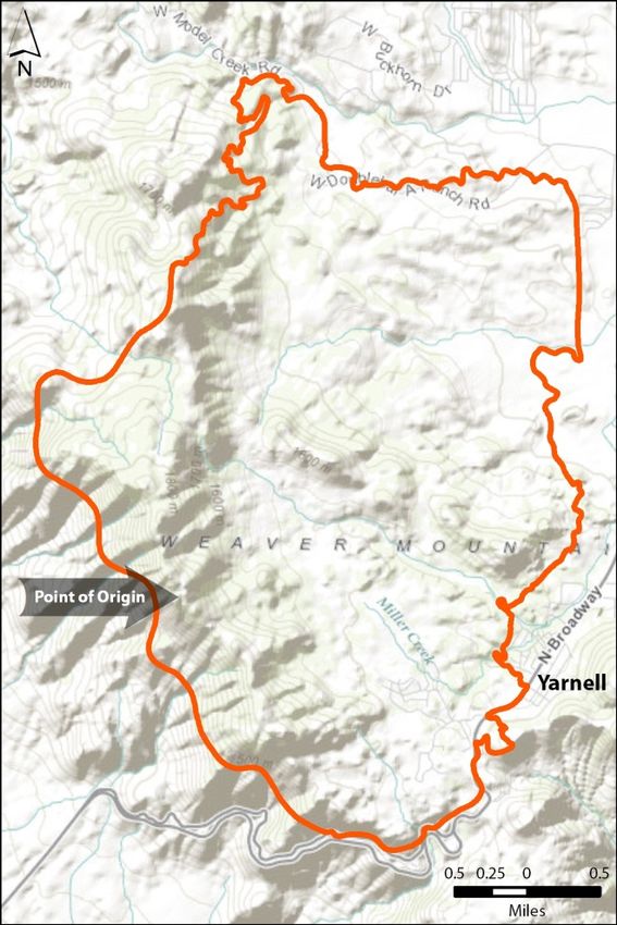
Granite Mountain IHC
                                                                Entrapment and Burnover Investigation | 9

By 1938, the Yarnell Hill Fire was an estimated 100 acres. The fire was approximately one mile from
structures in Peeples Valley and 2.5 miles from Yarnell, Arizona.

At 2200, the dispatch logs note that the ICT4 ordered additional resources including 14 engines, six
water tenders, two Type 2 Hotshot Crews, two bulldozers, and numerous aircraft.

At approximately 2340, the Structure Protection Group 1 Supervisor (SPGS1) arrived. After a briefing
from ICT4, SPGS1 was assigned to structure protection for
Yarnell and began assessing infrastructure threats,
including structures at risk, road networks and location of
safety zones, including Boulder Springs Ranch as well as          “The fire burned actively until
other locations for structure protection personnel. The           about 0330, maybe 0400. You
second Structure Protection Group 2 Supervisor (SPGS2)            could still see a lot of flames
arrived late in the evening of June 29 and worked with            until about 0600. Could see light
SPGS1 and the ICT4 to order additional resources and start        smoke, but that’s a deceptive
formulating a plan for June 30. SPGS2 described                   thing, if you’re around fire much,
                                                                  you know that there’s still a lot of
abnormally active fire behavior throughout the night. 13
                                                                  heat out there.” ~ ADOSH
firefighters remained on the fire.
                                                                       interview with SPGS2
June 30, 2013

On June 30, the ICT4, BLM Representative and SPGS1
met at 0100 to discuss using roads for indirect attack and
the use of point protection strategy (a firefighting strategy that involves protecting specific points from
the fire while not actively trying to line the entire fire’s edge2).

Between 0000 - 0400 minimum temperatures ranged from 70 to 80°F and maximum relative humidity
ranged from 25 to 35%.

At 0300, the ICT4, SPGS1 and SPGS2 ordered additional resources.

Afterwards at 0330, the SPGS2 and ICT4 discussed the fire situation, very active fire behavior and
probable outcomes for the strategy.

At 0700, a discussion between the ICT4, personnel from the previous shift, and incoming personnel
occurred and continued as personnel moved to the Incident Command Post (ICP) at Model Creek
School. The discussion included the incoming Incident Commander Type 2 (ICT2), two Operations
Section Chiefs (Planning OSC and Field OSC), SPGS1, a fire behavior analyst (FBAN), and deputies
from the Yarnell County Sheriff’s Office. The Granite Mountain IHC (GMIHC) Superintendent, who had
arrived prior to this meeting, listened in on much of the information sharing.

All personnel present were informed of the fire situation and tactics for June 30. The GMIHC
Superintendent was assigned as the Alpha Division Supervisor (DIVS A), transferring leadership of the
crew to the GMIHC Captain. The GMIHC were assigned to DIVS A with the task of establishing the
anchor point at the heel of the fire, using direct and indirect attack.

2
    ICS-209, page 2.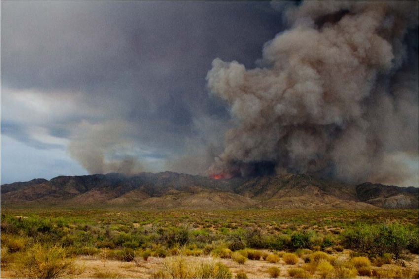
Granite Mountain IHC
                                                                Entrapment and Burnover Investigation | 10

After 0700 and before leaving for the ICP, the ICT2 informed everyone that the first priority was to have
an air operations plan developed so that air resources could operate safely over the fire. ICT2 stated:

“…the second priority was that we had people at the school that were gathering and that there would be
a briefing of those resources. And that none of us were to go anywhere including ICT4 until we got that
briefing done at the school to give clear leader intent.3”

This briefing occurred at 0930. GMIHC was not at the 0930 briefing at the ICP because they had
already been given their assignment and had departed for the fire. The ICT2 stated in an interview that,
at that time, he was unaware that the GMIHC had not been at the 0930 briefing.

At approximately 0800, the GMIHC arrived at the ICP. DIVS A received an operational briefing from the
Field OSC which included a safety briefing and weather forecast. The SPGS1 took them through
Yarnell and they stopped along Sesame Street. They discussed the location of the safety zone at the
Boulder Springs Ranch, and the SPGS1 reminded the DIVS A that the crew also had the previously
burned black area as a safety zone. In addition, during their internal crew briefing, all GMIHC
crewmembers were told the escape routes would be into the burned area or back to the crew carriers.

                                                               At 0854, a VLAT was ordered by ICT4. The
                                                               Incident Command Post (ICP) was
                                                               designated at the Model Creek School in
                                                               Peeples Valley.

                                                               At 0900, the Blue Ridge Interagency
                                                               Hotshot Crew (BRIHC) arrived at the ICP
                                                               and received a briefing.

                                                                    At 0930, the incoming ICT2 and overhead
                                                                    team members and firefighters were briefed
                                                                    by ICT4 at the ICP. Immediately after the
                                                                    briefing, the Planning OSC assigned several
                                                                    resources to Structure Protection Group 2 to
 Figure 2. Photo taken by a GMIHC member on two-track road early on
 June 30, 2013 during test-fire operations.                         protect homes. Sometime after the briefing,
                                                                    the Planning OSC directed the SPGS1 to
assess structures in the Yarnell area. SPGS1 confirmed that most homes were indefensible with
available resources.

The BRIHC was instructed by Field OSC to drive to the fire area and to meet with the SPGS1 on their
way to the fire. Soon after, DIVS A contacted BRIHC to discuss the fire.

At approximately 0930, DIVS A was briefed over the radio by a helitack crewmember who had been on
the fire overnight. Weather and fire behavior observations were relayed to DIVS A along with a fire size
estimate of 500 acres. DIVS A was at the top of the ridge near a helispot.

3
    ADOSH Interview with ICT2.
Granite Mountain IHC
Entrapment and Burnover Investigation | 11
At 1000, during a reconnaissance flight, a helicopter crewmember saw the GMIHC. The crew was
about 100 yards from the fire’s edge, heading for the burned area. By this time, the BRIHC had been
assigned to connect their line with GMIHC’s line.
At 1022, formal transfer of command from ICT4 to ICT2 was announced via radio.
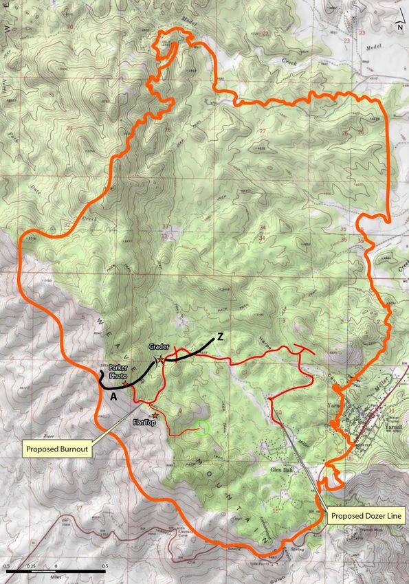
Around 1030, the BRIHC parked their crew carriers next to the GMIHC carriers. The BRIHC
Superintendent and Captain unloaded their utility task vehicle (UTV) and continued along Sesame
Street. They encounter SPGS1 who requested a Heavy
Equipment Boss (HEQB) to manage a dozer. The dozer was to
clear out the two-track road on both sides as far as possible to
provide access and prepare for a possible burnout. BRIHC “Fire behavior was extreme and
assigned one of their squad leaders, a qualified HEQB, to help. it occurred early in the day…
There was a line of fire a mile
The BRIHC Superintendent and Captain scouted the fire edge and ½ long… There were 40 to
while the HEQB took the dozer as far as an old abandoned 50 foot flame-lengths at 1030 in
grader to push a clear area around it. HEQB turned in the the morning… It was moving
direction of the saddle near GMIHC’s anchor point, then early that morning. This is
planned to turn around and clear out the two-track road unusual for Arizona.” ~ ADOSH
between Sesame Street and Shrine Road. During these interview with SPGS2
operations, the remaining crewmembers of the BRIHC stayed
with the crew carriers.
At 1030, the SPGS2 described the head of the fire as a 1.5-
mile line of fire at the north end towards Peeples Valley.
At 1045, the Yarnell County Sheriff’s Office issued evacuation notices to the residents of Model Creek
and the Double Bar A Ranch.
At 1100, the fire front in the basin was moving to the northeast. The tactics were to continue to use
SEATs at the heel of fire. Fire activity continued to increase as the day got warmer and drier. Cumulus
clouds built up to the north. Planning OSC contacted DIVS A via radio to determine if DIVS A could see
the cloud formations. DIVS A indicated that he could see the clouds and would keep an eye on the
weather.
By this time, the BRIHC Superintendent and Captain reached the old grader and were able to see
GMIHC working on the east side of the ridge, slowly burning off the two-track road. Over the radio, the
BRIHC Superintendent and Captain noted that the GMIHC was trying to get the fireline connected with
the two-track road so the fire could not burn back up the ridge.
Based on the escalating fire danger, the ICT2 informed the State of Arizona FMO that the Yarnell Hill
Fire needed a full IMT2.
At 1130, fire behavior became much more active. Fire personnel became engaged in structure
protection.
Between 1130 and 1145, the GMIHC conducted burnout operations, and DIVS A and ATGS discussed
tactical options. ATGS directed two SEAT drops at 1136 and 1145 directly onto the burnout operations.Granite Mountain IHC
Entrapment and Burnover Investigation | 12
DIVS A indicated via radio that the drops were not what he wanted. As a result of the drops, GMIHC
shifted tactics from building indirect line to going direct along the fire edge. During this same period, a
short squad of the GMIHC moved to the west side of the ridge and tied into the burned area and steep
rocky terrain. DIVS A considered this connection a good anchor point.
At 1154, after driving the two-track road on a UTV, the BRIHC Superintendent and Captain met DIVS A
and the GMIHC Captain at the anchor point. Over the next half hour, they discussed tactics and agreed
to use a GMIHC crewmember as a lookout (GM Lookout). The GM Lookout identified a lookout spot
down near the old grader at the bottom of the slope, and the GMIHC Captain agreed it would be a good
vantage point. DIVS A and the GMIHC Captain discussed communication problems which included
inappropriate tone guards on some radios with the BRIHC Superintendent and Captain.
Between 1200 – 1230, a weak southwest-northeast frontal boundary developed west of the fire
locations.
At 1204, ICT2 held a quick meeting with Command and General Staff, during which a VLAT was
dropping retardant on the fire. On top of the ridge, the short squad of the GMIHC rejoined their crew on
the east side of the ridge near the anchor point.
At 1210, Division Supervisor Zulu (DIVS Z) arrived at the BRIHC crew carriers and called DIVS A to
discuss a division break and resource assignments. DIVS Z also had radio problems, so he used a
BRIHC crew radio to talk with DIVS A over the Blue Ridge intra-crew frequency. DIVS A and DIVS Z
could not agree on the division break location or associated supervisory responsibilities.
At 1227, the BRIHC Superintendent and Captain
left the top of the ridge and brought the GM
Lookout down to the old grader site and drop him
off to be a lookout for BRIHC and GMIHC. The
BRIHC Superintendent and Captain continued to
drive roads looking for a way to connect the
planned suppression action.
At 1230, radio communication frequency changed
to Tactical Frequency 3 (TAC3) due to increased
communication from SPGS2.
At 1239, the GM Lookout was dropped off at the
old grader. After hiking to the lookout spot
Figure 3. Photo taken by a GMIHC member on two-track road
early on June 30, 2013 during retardant drop on their burn out
(roughly 120 yards north of the old grader), both
operations. DIVS A and the GM Lookout confirmed they had
a good view of each other and the fire edge. At
this time, the head of the fire had pushed north toward structures in Peeples Valley. The fire was also
backing towards the GMIHC location. Drainages were located between the crew and the fire. The crew
anticipated the fire would become more active around mid-afternoon, and expected no additional
support because the focus of aircraft and firefighters was at the head of the fire on the north end.
Consequently, the GMIHC planned to construct line directly along the fire edge. When GMIHC reachedGranite Mountain IHC
Entrapment and Burnover Investigation | 13
a rock face they stopped to eat lunch. After lunch, the crew worked their way back, reinforcing their line
as they went, ensuring they had a good anchor point.
For lookouts, they had DIVS A on a knob, GM Lookout down by the grader and GMIHC Captain near
the anchor or in the immediate vicinity of the crew. Each of these individuals had been looking out for
the other two lookouts, the crew and the fire. In the event the fire changed direction, the GM Lookout
had geographic trigger points established for the crew and for himself. The crew had on-going contact
with the BRIHC, SPGS1, and Planning OSC and talked among themselves about the incoming
thunderstorms. They also contacted air resources and adjoining forces as needed.
At 1300, the weak southwest-northeast frontal
boundary sharpened and slowly moved over the
fire area. The ASFD District Forester and the
ICT2 developed a complexity analysis. Based
upon this analysis, the ICT2 recommended
ordering a full Type 2 IMT. However, the District
Forester and the State FMO changed the
recommendation to a Type 1 IMT and placed the
order through ADC.
By 1330, the fire had advanced towards the ICP
and forced personnel to move vehicles to keep
them from being burned.
At 1402, the FBAN received a weather update
from the NWS. The FBAN was informed that
thunderstorms were predicted to occur east of
the fire and might produce wind gusts up to 35 to
45 miles per hour with winds out of the northeast.
This information was relayed to Planning OSC
and Field OSC via Tactical Frequency 1 (TAC1).
At 1420, the resources assigned to Structure
Protection Group 2 located north of the fire
retreated due to the fire near the Double Bar A
Figure 4. Photo taken by a GMIHC Crew member on two-track
Ranch. road on June 30, 2013.
At 1447, the second Aerial Supervision Module (ASM2) arrived to relieve ASM1. After a 10 minute
briefing, ASM2 met an arriving VLAT and supported structure protection north of the fire. However, fire
conditions changed which shifted priorities towards Yarnell. The ATGS was still on scene overhead.
At 1500, the outflow boundary originated from thunderstorms to the northeast of the fire area.
At 1526, the FBAN received an update from the NWS. North to northeast winds of up to 40 and 50
miles per hour were now expected from the thunderstorm outflows. This information was relayed to
Planning OSC and Field OSC via TAC1.Granite Mountain IHC
Entrapment and Burnover Investigation | 14
At 1530, winds changed course by 90° to the south-southwest. There was approximately three miles of
an active flaming front. Between 1530 and 1545, Planning OSC and DIVS A discussed the
thunderstorm cells both to the north and south of the fire. Also at this time, the wind picked up and
shifted direction from the southwest to the west-northwest. There was spotting and heavy ash fell onto
fire personnel working in the youth camp area. The two-mile flanking fire started to look like a head fire
and was moving to the southeast.
At 1540, the fire reached the first geographic trigger point for SPGS1 and an evacuation of the city of
Yarnell was requested. DIVS A called Planning OSC and communicated that the retardant line and
dozer lines were compromised but that GMIHC was in the burned
area.
At 1545, the SPGS1 met up with Field OSC. The Field OSC called “…it wasn’t like an outflow. It
ASM2, indicating that the winds were getting erratic and was pushing the fire in this
requested that ASM2 check on the GMIHC when they got a direction. It wasn’t a ten-minute
chance. bust and things got back to
normal. It was two solid hours…”
At 1550, several communications occurred at or near the same ~ ADOSH interview with SPGS2
time. Field OSC called DIVS A by radio to make sure that DIVS A
was aware of the latest weather update. DIVS A confirmed the
update and noted that the winds were getting “squirrely” on the
ridge. DIVS A informed Field OSC that GMIHC moving off the top.
At around the same time, the ATGS informs DIVS A that the fire was headed toward Yarnell and could
reach the town in one to two hours. In addition, the GMIHC’s crew carriers were in the path of the fire.
DIVS A acknowledged this information and planned to address the problem.
At about 1550, the GM Lookout was taking weather observations when the GMIHC Captain called to
relay the weather update. GM Lookout acknowledged the message and continued to take weather
observations. By the time the GM Lookout completed the weather observations and scanned the
surroundings as well as the crew location, the fire had started building and the wind was beginning to
shift. GM Lookout recognized the fire had hit the first trigger point established for his safety. After
informing the GMIHC Captain, GM Lookout moved towards the open area at the old grader. The
GMIHC Captain received the information relatively calmly.
As the GM Lookout hiked toward the grader, he noted the options open to himself including an alternate
lookout spot further up the road, a possible shelter deployment site near the grader, and a little clearing
just down from his original lookout spot where he could deploy his fire shelter if needed. The BRIHC
Superintendent was driving back to meet DIVS A for a face-to-face meeting. He met with the GM
Lookout as he reached the grader.
The BRIHC Superintendent and Captain picked up GM Lookout with their UTV, and called GMIHC on
the radio. GMIHC informed BRIHC Superintendent and Captain that they had good visibility, they were
in the burned area and they were assessing their situation. As GM Lookout departed the lookout spot,
he believed the GMIHC was in the black and were watching the fire and that DIVS A was scouting4.
4
ADOSH Interview with GM Lookout.Granite Mountain IHC
Entrapment and Burnover Investigation | 15
Between 1550 and 1554, some GMIHC crewmembers took photos of the fire and sent text messages
to family members about the fire.
At 1555, fire was burning along the ridge north of Yarnell. The SPGS1 lost use of an air-to-ground radio
frequency, and communication was interrupted. The BRIHC Superintendent dropped the GM Lookout
off at the GMIHC Superintendents truck. The GMIHC crew carriers were moved. On the GMIHC intra-
crew frequency, GM Lookout heard the DIVS A and GMIHC Captain discussing the options of whether
to stay in the black or to move5.
At 1558, ATGS abruptly leaves the fire and goes to Deer Valley. He turned air tactical operations over
to ASM2 who was busy dealing with lead plane duties at the time. ASM2 got a very brief update from
ATGS that did not include division breaks locations and the location of the on-the-ground firefighters6.
ASM2 had been ordered as a lead plane because ATGS functions were covered.
At 1600, the fire reached Yarnell, Arizona and evacuations were underway. About this time, the ASM2
overhears radio communication referring to a safety zone. ASM2 contacted Field OSC to clarify the
exchange. Planning OSC confirmed that the GMIHC was in “a good place,” in the burned area. ASM2
was asked to check on the crew, but it was not an urgent request. Soon after, ASM2 communicated
directly with DIVS A. DIVS A informed ASM2 that they were moving and indicated that everything was
okay.
At 1604, a GMIHC crewmember sent a photo
of the fire to family members with a text
message about the fire.
At 1618, the outflow boundary neared the
northern end of fire area moving at 16 miles
per hour.
At 1620, thunder was heard by fire personnel
near Yarnell.
At 1622, the fire had reached the second
geographic trigger point and firefighters in the
Shrine area started moving out of the area Figure 5. Photo taken from Congress, Arizona on June 30, 2013.
towards Highway 89. The BRIHC had left the Courtesy of Matt Oss.
fire area and attempted to contact the SPGS1
to affirm that the rest of the firefighters were out of the fire area.
At 1624, Dopplar radar showed a fire plume at a height of approximately 31,500 feet that grew to
38,700 feet by 1633.
At 1630, the outflow boundary moved across the southern end of fire. Also at this time, firing operations
are completed in the Peeples Valley area. The wind changed direction and fire activity diminished in
this area.
5
ADOSH Interview with GM Lookout.
6
ADOSH Interview with ASM2.Granite Mountain IHC
Entrapment and Burnover Investigation | 16
At 1634, the outflow boundary crested the ridge for the first time in the direction of Yarnell (Figure 5,
previous page).
At 1637, ASM2 flew a drop path for a VLAT north of Yarnell from west to east. This drop went over
DIVS A location at the time. DIVS A communicated with ASM2 confirming the drop path. ASM2 circled
the south end of the fire above Yarnell to line up a final flight path for a tanker drop.
At 1639, ASM2 was in the middle of a discussion with Field OCS on the air-to-ground frequency when
an over-modulated and static-filled transmission came over the air-to-ground frequency. More broken
communication was exchanged and due to poor reception, ASM2 could only understand fragments.
The rapid advance of the fire toward Yarnell had generated much radio traffic about structure
protection. ASM2 assumed the broken and unclear transmission was one of the structure protection
units calling to request a retardant drop. ASM2 did not suspect it was GMIHC since they had been in a
safe area when he talked to them earlier.
By 1640, the last firefighters, with the exception of the GMIHC, reached Highway 89 and confirmed on
TAC1 with SPGS1 that they were safe. At approximately the same time, SPGS1 directed ASM2 to drop
retardant at his discretion to stop the fire from reaching Yarnell.
At 1642, the outflow boundary crested the
ridge for the second time (Figure 6).
Between 1640 and 1642, the final
communication occurred between GMIHC,
the ASM2, and Field OSC. The exchange
affirmed that GMIHC needed air support.
Field OSC released ASM2 from structure
suppression to help GMIHC. ASM2
contacted DIVS A to request their location.
DIVS A informed ASM2 that their escape
route had been cut off and that they were
preparing a deployment site. They were
burning out the brush around them. ASM2 Figure 6. Photo taken from Congress, Arizona on June 30, 2013.
Courtesy of Matt Oss.
asked if they were on the south side of the
fire and DIVS A affirmed that location. That was the last communication with DIVS A.
Soon after 1642, the GMIHC deployed their fire shelters and were overrun by the Yarnell Hill Fire.Granite Mountain IHC
Entrapment and Burnover Investigation | 17
FIRE BEHAVIOR AND FIRE WEATHER SUMMARY
The review completed by WFA of the documented weather and fire behavior events during the Yarnell
Hill fire (June 28 to 30, 2013) concurs with the Serious Accident Investigation Team (SAIT) Final Report
detailing the weather and fire behavior events of the Yarnell Hill Fire (published on September 23,
2013). The following summary will contain analysis as well as excerpts from the SAIT Final Report and
from other independent sources.
Fire Environment
Central Arizona is in the physiographic Transition Zone,
typified by an overall northwest-trending, mountainous
terrain. As indicated by its title, the Transition Zone is a
large area between the northern half of Arizona typified
by the semi-arid Colorado Plateau, and the southern
half of Arizona that is part of the large Basin and Range
Province.
The Transition Zone has characteristics from both
regions, consisting of steep, rugged terrain interspersed
by valleys. Because of this, weather conditions can vary
within relatively small areas.
Within this large physigraphic region, the Weaver
Mountains are located in central-west Yavapai County,
bounded by the Hassayampa River, and typical of the
Transition Zone. The Yarnell Hill Fire occurred roughly
in the center of the Weaver Mountains.
Elevations in the fire area ranges from 4,500 to 6,052
feet above sea level. The immediate area is bounded by
a north-south trending mountain ridge to the west (see
Figure 7), with a spur-ridge, trending west-northwest to
the east-southeast, projecting from the main ridge at
Figure 7. Topographic map west of Yarnell, Arizona. The
about the mid-point of the fire and extending towards Yarnell Hill Fire perimeter outlined in red, and the point
Yarnell, Arizona. of origin indicated with a large, black arrow.
Relatively flat terrain typify the northeastern side of the fire area. Slopes of up to 50%, with isolated
steeper sites, can be found on the western ridges of the fire area.
Rock outcroppings in the fire area are common and scattered throughout the hills west of Yarnell,
Arizona.Granite Mountain IHC
Entrapment and Burnover Investigation | 18
Fuel/Vegetation Conditions
Prior to the Yarnell Hill Fire, the area west of Yarnell, Arizona supported scattered, short trees such as
juniper (Juniperus deppeana) within dense stands of brush consisting of chaparral species such as
turbinella oak (Quercus turbinella), catclaw acacia (Acacia greggii), and manzanita (Arctostaphylos
spp.). The brush vegetation varied in height from three to eight feet depending on site conditions.
Due to better soil conditions (higher moisture), drainages on the site supported thicker and taller
vegetation. There was also a heavier than average cured grass component in the fuel complex due to
abundant rain during the 2012 monsoon season.
In addtion, no major vegetation disturbance are known to have occurred in the fire area for more than
40 years (the last documented fire was in 1966).
These conditions characterize substantial fuel continuity, both horizontally and vertically, which has the
potential to support high fire rate of spreads and intensities, which in turn can introduce challenges to
firefighter mobility.
On June 30, 2013, recorded fine fuel moistures (an indication of the probability of a fire start or the ease
at which a fire will start) were:
6% FOR SHADED FUELS AND
3% FOR NON-SHADED FUELS.
Calculated probability of ignition was:
60% IN THE SHADE AND
90% IN NON-SHADED AREAS.
Live fuel moisture (an indication of the water stress on live vegetaion as well as the flammability of live
fuel) measurements were taken five miles from the fire location. These indicated varying levels of
deviation from average. Ceanothus and mahogany had much lower than average moisture contents
while juniper and oak were at or slightly above average7. The National Live Fuels Database records
indicate that the Sonoran Scrub Oak live fuels were also below average in their moisture content as of
June 15, 20138.
Coupled with the right weather conditions, these fuel characteristics ensure moderate to extreme fire
behavior.
7
Yarnell Hill Fire, SAIT Report, September 23, 2013.
8
See Appendix B – National Fuel Moisture Database Figure B-1.Granite Mountain IHC
Entrapment and Burnover Investigation | 19
Fire Weather
The National Oceanic and Atmospheric Administration’s (NOAA) National Climatic Data Center (NCDC)
monitors and assesses climatic weather data that describe drought conditions. For the months leading
up to the Yarnell Hill Fire, the described drought conditions indicated an abnormally dry fuel bed in the
fire area.9
Coupled with the unusually low live fuel moisture readings, these conditions prompted the Predictive
Services Section of the Southwest Coordination Center (SWCC) to issue a Fuels and Fire Behavior
Advisory that discussed the area’s fire potential. This included a section titled Concerns to Firefighters
and the Public. Below is their list of concerns:
SURFACE FIRE WILL QUICKLY TRANSITION TO CROWN FIRE AND ONLY REQUIRES LOW
TO MODERATE SURFACE FIRE INTENSITY TO TRANSITION.
ACTIVE/RUNNING CROWN FIRE HAS PRODUCED LONG RANGE SPOTTING UP TO ONE
MILE UNDER THE INFLUENCE OF AN UNSTABLE ATMOSPHERE.
ACTIVE FIRE BEHAVIOR CAN EXTEND WELL INTO NIGHT AND EARLY MORNING HOURS
EVEN WITH MODERATE RELATIVE HUMIDITY (RH) RECOVERY.
THUNDERSTORM ACTIVITY WILL CREATE A MOSAIC PATTERN OF SURFACE FUEL
MOISTURES. SURFACE FIRE INTENSITY AND FIRE BEHAVIOR MAY CHANGE ABRUPTLY
WHEN FIRES CROSS THESE BOUNDARIES OF MOIST AND DRY SURFACE FUELS.
On pages 68 to 76 of the SAIT Final Report, the weather discussion describes a very detailed analysis
of the weather events and timing of these events during the Yarnell Hill Fire. The Cliff Mass weather
blog also gives a detailed analysis of the thunderstorm movements and outflow progression as it
impacted the Yarnell Fire area on June 30, 201310. These summaries show a clear progression of
weather and fuel conditions that would lead to extreme fire behavior.
Specifically, the Stanton RAWS weather graphs11 for the 30th of June 2013 clearly indicate a shift in
wind direction as it occurred at the Stanton site, approximately four miles south-southeast of Yarnell. At
around 1700, the Stanton RAWS wind speed readings also indicate an abrupt increase in the sustained
winds from 10 to 25 miles per hour, as well as wind gusts increasing to over 40 miles per hour in that
same time frame. With the outflow boundary moving at about 16 miles per hour12, the outflow should
have impacted the fire area at least one half hour earlier assuming the fire’s northern edge was in the
Peeples Valley area at the time.
9
See Appendix B – Figures B-2 and B-3.
10
Cliff Mass Weather Blog: The Yarnell Hill Fire: The meteorological Origins (Yarnell Hill Fire, SAIT Report,
September 23, 2013, accessed on October 28, 2013).
11
See Appendix B – Figures B-4, B-5, B-6.
12
SAIT Final Report, page 72.Granite Mountain IHC
Entrapment and Burnover Investigation | 20
USING WEATHER AND FUEL CONDITIONS TO PREDICT FIRE BEHAVIOR
The National Fire Danger Rating System (NFDRS) takes into account current and antecedent weather,
fuel types, and both live and dead fuel moisture to predict burning conditions and threat of fire13. The
aim of the system is to provide fire fighting personnel with qualitative and/or numeric indices to describe
an area’s protection needs, and are based on pre-determined fuel models.
Below is a presentation of the NFDRS fuel models that represent fuels found in the Yarnell area at the
time the Yarnell Hill Fire occurred.
Fuel Model B represents mature, dense fields of brush 6 feet or more in height. One-fourth or more of
the aerial fuel in such stands is dead. Foliage burns readily. Model B fuels are potentially very
dangerous, fostering intense fast-spreading fires. This model is for California mixed chaparral generally
30 years or older. The B model may be used for the New Jersey pine barrens. The F model is more
appropriate for pure chamise stands.
Fuel Model K represents slash fuels from light thinnings and partial cuts in conifer stands.. Typically the
slash is scattered about under an open overstory. This model applies to hardwood slash and to
southern pine clearcuts where the loading of all fuels is less than 15 tons per acre.
Fuel Model T represents the bothersome
sagebrush-grass types of the Great Basin and
the Intermountain West. The shrubs burn easily
and are not dense enough to shade out grass
and other herbaceous plants. The shrubs occupy
at least one-third of the site. Fuel Model T might
be used for immature scrub oak and desert
shrub associations in the West, and the scrub
oak-wire grass type in the Southeast.
Fuel Model G is used for dense conifer stands
where there is a heavy accumulation of litter and
downed woody material. Such stands are
Figure 8. Helm’s Ranch pre-fire photo of fuels and topography.
typically over-mature and may also be suffering
insect, disease, wind, or ice damage - natural events that create a very heavy buildup of dead material
on the forest floor. The duff and litter are deep and much of the woody material is more than 3 inches in
diameter. The undergrowth is variable, but shrubs are usually restricted to openings. Types meant to be
represented by Fuel Model G are hemlock-sitka spruce, Coast Douglas-fir, and wind-thrown or bug-
killed stands of lodgepole pine and spruce. This model is often used as a reference for tracking the
effects of long-term drought on an area’s fuels.
Using the Stanton RAWS historical data (13 years of weather data) and Fuel Model B (California
chaparral) pocket card as prepared for the Tonto National Forest, the Energy Release Component
(ERC) for June 30, 2013 was 119. This ERC value is above the 90th percentile and indicates that only
13
USFS – Wildland Fire Assessment System website (http://www.wfas.net/index.php/nfdrs-fuel-model-static-
maps-44, access on November 3, 2013).Granite Mountain IHC
Entrapment and Burnover Investigation | 21
10% of the 13,252 days from 1968 to 2009 were hotter and drier than the conditions on June 30, 2013.
The prepared pocket cards for this area and this time period shows that two significant historical fires
occurred in 2000 and 2004 with ERC’s of 113 and 119. Using the NFDRS pocket card prepared for the
Prescott Forest West Zone14 (which encompasses the Yarnell area) and using the Stanton RAWS data
in a NFDRS Fuel Model G, the calculated ERC for June 30, 2013 was 108.
If the fire fighters on the Yarnell Hill Fire had either the Tonto National Forest or Prescott National
Forest Pocket Card, and during a briefing were told that the predicted ERC for the day (June 30, 2013)
was 100 or greater in any fuel model, the pocket card would have indicated an elevated potential for
large, rapidly growing, and difficult to manage fires15.
Fire Behavior
Fire personnel analyse fire behavior to provide fire fighters in the field with current and anticipated fire
behavior based upon current and predicted fire weather and fuel conditions. BehavePlus is a Microsoft
Windows software application used to predict wildland fire behavior for fire management purposes, and
is designed for use by trained, professional wildland fire planners and managers familiar with fuels,
weather, topography, wildfire situations, and the associated concepts and terminology. Using the
recorded local weather as well as the observations recorded by various fire personnel on the Yarnell
Hill Fire, the following fire behavior outputs were modeled using BehavePlus.
On June 30, 2013, the Fire Behavior Analyst (FBAN) selected two fuel models from a set of 40 fuel
models developed by Scott and Burgan16 that best matched the existing vegetation and fuel loadings in
the Yarnell area.
The FBAN chose to use GS2 which represents a Grass-Shrub fuel bed with moderate grass loads, high
spread rates and moderate flame lengths. This model represents shrubs up to 3 feet high. The primary
carrier of fire in this model is grass and the moisture of extinction is low. This model would best
represent the grass-sage areas within the Yarnell Hill Fire area.
The FBAN also chose to use SH5 which represents a high load, dry climate shrub fuel complex where
the primary carrier of fire is woody shrubs and shrub litter. Depth of fuels is 4 to 6 feet with a high rate
of spread and very high flame lengths are possible. The moisture of extinction in this model is high.
This fuel model would best represent the chaparral-like conditions for the Yarnell area fuels and is a
good choice.
14
The Prescott National Forest West Zone pocket card is based on two weather stations, Crown King and Iron
Springs RAWS, both of which are within 40 miles of the Yarnell Hill Fire area.
15
Appendix B – Figures B-7 to B-12.
16
Scott and Burgan, 2005, RMRS-GTR-153.Granite Mountain IHC
Entrapment and Burnover Investigation | 22
Using model SH5, the following fire behavior outputs were produced for the June 30 conditions, using a
mid-flame windspeed from 5 to 40 miles per hour.
MIDFLAME RATE OF SPREAD FLAME
WIND SPEED (MAX) LENGTH
MI/H MI/H FT
0 .1 5.9
5 1.1 18.2
10 2.4 26.1
15 3.8 32.3
20 5.2 37.7
25 6.8 42.5
30 8.4 46.9
35 10.1 51.0
40 11.8 51.0
Table 1. Rate of spread and flame length predictions.
The Rate of Spread (ROS) is the speed at which the fire could travel under the modeled weather and
fuel conditions. Tabe 1 shows the outputs in miles per hour for ROS. Before the wind shift impacted the
Yarnell Hill fire, the measured windspeeds at Stanton RAWS were an average of 10 to 15 miles per
hour, the expected rate of spread would have been up to 3.8 miles per hour at the head of the fire, with
flame lengths up to 30 feet in the brush model. This would help explain the difficulty of control that the
suppression forces were having with the Yarnell Hill fire as it headed north and west toward Peeples
Valley.
After the wind shift and increase in wind speed occurred, with the outflow boundary reaching the fire
area and the wind speeds increased to 40 miles per hour, the ROS would have reached up to 12 miles
per hour for the flaming front. With wind speeds of this nature, spotting (lofting of embers ahead of the
flaming front which in turn can start new fires) would have been irrelevant as the fire was moving so fast
any spots would have been immediately over run by the flaming front. As noted in the SAIT report,
when the fire moved around the granite ridge and the GMIHC were again able to see the fire, they
would have had from 4 to 6 minutes to prepare a deployment site.
The SAIT report modelled the fire’s spread, intensities and flame lengths using the Wildfire Decision
Support System (WFDSS). The following figures are Google Earth™ outputs from this modeling effort
and they are used to clarify the fire’s rapid spread and change in direction.
At 1000, the model used the existing perimeter and indicated potential flow paths for the fire as it
spread to the north toward Peeples Valley (Figure 9 – next page).Granite Mountain IHC
Entrapment and Burnover Investigation | 23
Figure 9. Yarnell Hill Fire outlined in cyan. Red lines indicate fire growth and path, and the black line represents aerial
suppression efforts. The deployment site is labeled and marked with a red triangle. Winds are shown from the south-southwest
at 25 miles per hour. Photo courtesy of SAIT, 2013.Granite Mountain IHC
Entrapment and Burnover Investigation | 24
At 1500, the fire had spread to the east of Peeples Valley and is beginning to turn toward Yarnell
(Figure 10).
Figure 10. Yarnell Hill Fire outlined in green. Red lines indicate fire growth and path, and the black line represents aerial
suppression efforts. The deployment site is labeled and marked with a red triangle. Winds are shown from the southwest at 25
miles per hour. Photo courtesy of SAIT, 2013.Granite Mountain IHC
Entrapment and Burnover Investigation | 25
Between 1600 and 1630, the fire has moved further east and crossed the retardant line and dozer line
as it moves toward Yarnell (Figure 11).
Figure 11. Yarnell Hill Fire outlined in yellow. Red lines indicate fire growth and path, and the black line represents aerial
suppression efforts. The deployment site is labeled and marked with a red triangle. Winds are shown from the west-southwest
at 25 miles per hour. Photo courtesy of SAIT, 2013.Granite Mountain IHC
Entrapment and Burnover Investigation | 26
By 1650, the model shows it past the deployment site and the Boulder Ranch and entering Yarnell
(Figure 12).
Figure 12. Yarnell Hill Fire outlined in purple. Red lines indicate fire growth and path, and the black line represents aerial
suppression efforts. The deployment site is labeled and marked with a red triangle. Winds are shown from the north-northeast
at 45 miles per hour. Photo courtesy of SAIT, 2013.Granite Mountain IHC
Entrapment and Burnover Investigation | 27
Oriented due north, Figure 13 shows the Wind Wizard modeling results that indicate winds speeds and
directions as the fire burns through the deployment site. Wind speeds could have reached above 50
miles per hour in the area of the deployment.
Figure 13. Deployment site at foreground, center of map. Photo courtesy of SAIT, 2013.
As modeled for the SAIT Final Report, the fire spread would have involved two flaming fronts after the
frontal boundary began driving the fire to the southeast and then to the south. The first front would have
moved up through the valley past the lunch spot, and over the two-track to crest on the ridge above the
lunch spot and two-track area.
From a vantage point to the south at Congress, Arizona, the following two photos were taken of the
Yarnell Hill Fire at approximately the time of the burnover. The first shows the outflow boundary as it
crested the ridge prior to the fire running up through the deployment site to the ridge. And the second
shows the outflow boundary as it continues over the ridge and the fire has run up through the
deployment site and south to the ridgeline (Figures 14 and 15 on next page).Granite Mountain IHC
Entrapment and Burnover Investigation | 28
th
Figure 14. Yarnell Hill Fire, June 30 , 2013, approximately 1640. Photo courtesy of Matt Oss.
th
Figure 15. Yarnell Hill Fire, June 30 , 2013, approximately 1640. Photo courtesy of Matt Oss.Granite Mountain IHC
Entrapment and Burnover Investigation | 29
DISCUSSION
The following discussion identifies areas of concern where difficulties existed on the Yarnell Hill Fire.
Our conclusions are based upon professional experience and the industry standards for wildland fire
that include the 10 Standard Firefighting Orders, 18 Watch Out Situations, Lookouts Communication
Escape Routes and Safety Zones (LCES), 2013 Interagency Standards for Fire and Aviation
Operations (Red Book), Incident Response Pocket Guide (IRPG), and the Wildland Fire Incident
Management Field Guide (PMS 210).
The analysis of the decision making process has led to the identification of four primary areas of
concern:
ARIZONA STATE FORESTRY DIVISION
YARNELL HILL FIRE INCIDENT MANAGEMENT
DEPARTURE FROM STANDARD PRACTICES
FATIGUE
Below we highlight the specific conditions and events that support why these four areas of concern
resulted in the burnover.
PRE-EXISTING CONDITIONS IN YARNELL
Yarnell, Arizona is a classic example of the wildland urban interface (WUI) situation. The structures
within town are located in chaparral scrubland that had not burned in at least 40 years. The Yavapai
Communities Wildfire Protection Plan approved in 2004 provides direction for hazard fuel removal on
lands including the Yarnell area. The Bureau of Land Management has been working to reduce hazard
fuels in Peeples Valley and Yarnell. Between 2005 and 2011, $169,000 was spent in the Yarnell area to
clear 375 acres, and $27,500 was spent in 2007 to clear 40 acres near Peeples Valley17.
Based upon the Arizona State Forestry Division (ASFD) 2013 Season Outlook released in March 28,
2013, the state of Arizona was in a drought situation. Fine fuel moistures were approaching single digits
as early as late March and the Energy Release Component was above normal and trending upward.
Yavapai County had live green fuel moistures in chaparral that were below normal. Yarnell was
mentioned as having chaparral with below average live fuel moisture and older chaparral stands with
high dead-to-live ratio that may “prove resistant to control efforts due to the low live fuel moistures.” The
dry winter and late spring precipitation had led to a delay in new seasonal fine fuel growth. The
conclusion of the report is that the Yarnell area had high fire potential18.
17
AZCentral.com, Brush Clearing Saved Homes, July 17, 2013.
18
2013 Arizona Fire Season Outlook, page 10.Granite Mountain IHC
Entrapment and Burnover Investigation | 30
Arizona State Forestry Division
The ASFD is responsible for fire suppression operations on 22 million acres of State Trust land and
private property located outside of incorporated communities19. ASFD has employees that work on
three districts and in the state office. Each District has a District Forester who, in the case of the
Phoenix District, also fills the role of FMO. The Phoenix District Office maintains field offices in Prescott
and Yuma, and has three fire crew coordinators throughout the District. Yarnell is part of the Phoenix
District.
ASFD responds to an average of 476 wildfires annually (based upon a 10 year average, with 2006
having substantially more fires than the other nine years), which burn an average of 24,000 acres per
year. ASFD supports twelve 20-person Arizona DOC fire crews, supplemental summer preparedness
resources, and has cooperative agreements with 250 fire departments and federal agencies20.
ASFD had the authority for the suppression of Yarnell Hill Fire.
INCIDENT ACTION PLAN
The Arizona Revised Statute 37-623 Section on Wildfire Suppression Strategies states that wildfire
suppression operations shall be conducted to
“minimize both suppression costs and resource losses, consistent with resource values to be protected
and shall consider fire behavior, the availability of suppression resources, the values of the natural
resources and property at risk, and potential cost of suppression.”
In order to meet the intent of this statute, a comprehensive and coherent Incident Action Plan (IAP)
should have been articulated. An IAP “contains objectives reflecting the overall incident strategy and
specific tactical actions and supporting information for the next operational period. The plan may be oral
or written.”21
Based upon incident documents and interviews, we believe that the ICT4 worked hard to develop and
convey the incident strategy and tactics to resources as they arrived on the fire. However, given the
complexity of the rapidly evolving fire situation, the ICT4 did not adequately brief incoming resources on
June 29 or provide a written IAP for the incoming IMT2 on June 30.
Based upon our interview with ICT2, we have concluded that when ICT2 arrived at the Incident
Command Post (ICP) he observed an obviously fatigued ICT4. Realizing that the fire situation was very
dynamic and intensifying, ICT2 took over the fire despite the fact that certain key members of the team
had not yet arrived. ICT2 provided the 0930 briefing to resources that had arrived at the ICP. Some
resources were not at the 0930 briefing because they had already been assigned and working on the
fireline. Based upon incident documents and interviews, ICT2 was working in a diligent and
professional manner, although the situation was deteriorating.
19
Arizona State Forestry Division website (http://www.azsf.az.gov/, accessed on November 3, 2013).
20
Arizona House of Representatives, Committee on Agriculture and Water, Minutes of Meeting, March 3, 2011.
21
NWCG Glossary of Wildland Fire Terminology.You can also read