When you can't see the city for the trees. A joint analysis of the Sonian Forest and urban reality - OpenEdition Journals
←
→
Page content transcription
If your browser does not render page correctly, please read the page content below
Brussels Studies
                          La revue scientifique électronique pour les recherches
                          sur Bruxelles / Het elektronisch wetenschappelijk
                          tijdschrift voor onderzoek over Brussel / The e-journal
                          for academic research on Brussels
                          Collection générale | 2012

When you can’t see the city for the trees. A joint
analysis of the Sonian Forest and urban reality
Quand les arbres cachent la ville. Pour une analyse conjointe de la forêt de
Soignes et du fait urbain
Als we door het bos de stad niet meer zien: voor een gezamenlijke analyse van
het Zoniënwoud en de verstedelijking

Lee Christopher Roland

Electronic version
URL: http://journals.openedition.org/brussels/1101
DOI: 10.4000/brussels.1101
ISSN: 2031-0293

Publisher
Université Saint-Louis Bruxelles

Electronic reference
Lee Christopher Roland, « When you can’t see the city for the trees. A joint analysis of the Sonian
Forest and urban reality », Brussels Studies [Online], General collection, no 60, Online since 02 July
2012, connection on 30 April 2019. URL : http://journals.openedition.org/brussels/1101 ; DOI :
10.4000/brussels.1101

                   Licence CC BY
w w w. b r u s s e l s s t u d i e s . b e
                                                                                                                                                                                                             the e-journal for academic research on Brussels
Brussels Studies is published thanks to the support of Innoviris (Brussels Institute for Research and Innovation - Brussels-Capital Region)

                                                                                                                                              Number 60, July 2nd 2012. ISSN 2031-0293

                                                                                                                                              Lee Christopher Roland

                                                                                                                                              When you can't see the city for the trees.
                                                                                                                                              A joint analysis of the Sonian Forest and urban reality
                                                                                                                                              Translation: Jane Corrigan

                                                                                                                                              Considering the width of the Sonian Forest 'ecotone', the forest cannot be studied as 'nature' which is independent of urban dy-
                                                                                                                                              namics. In this part of the urban area, the distribution of forms of developed land did not take place in the form of isotropic rings
                                                                                                                                              moving outwards from a central area represented by the Pentagon, but rather according to a second element historically tied to the
                                                                                                                                              latter, i.e. the forest itself. This article presents a
                                                                                                                                              chronological overview of the relationships between
                                                                                                                                              the mass of plant life referred to as 'the forest' and Lee Christopher Roland has a degree in architecture from I.S.A. St-Luc Bruxelles, and studied as
                                                                                                                                              urban forms and the lifestyle practices associated an exchange student at McGill University, Canada. Following his professional training periods, in 2009
                                                                                                                                              with the Brussels urban area today. It first highlights he began to work as a researcher and teacher in the Faculté d'architecture, d'ingénierie architec-
                                                                                                                                              the asymmetry created by the forest during the An- turale, d'urbanisme (LOCI) at Université Catholique de Louvain. He is carrying out research entitled Le
                                                                                                                                              cien Régime in terms of the distribution of activities territoire en batterie : Bruxelles comme palimpseste in partnership with Bruxelles-Environnement in
                                                                                                                                              and developed land. It then reviews the role played the framework of the convention Prospective Research for Brussels (Innoviris). He recently published
                                                                                                                                              by the forest in the processes of urbanisation in the an article entitled Épaisseur empirique, le tiers état.
                                                                                                                                              south/southeast of Brussels in the 19th and 20th
                                                                                                                                              centuries. Finally, it explains the impact of these
                                                                                                                                              interactions on the construction of the forest land-                                           Lee Christopher Roland, +32(0)10 47 23 41, lee.roland@uclouvain.be
                                                                                                                                              scape and on its management, before taking a
                                                                                                                                              stance with respect to how the forest should be                                    Benjamin Wayens (Senior Editor), +32(0)2 211 78 22, bwayens@brusselsstudies.be
                                                                                                                                              dealt with today.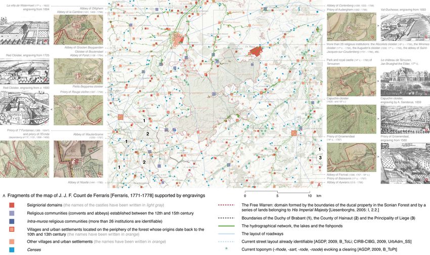
Lee Christopher ROLAND,
                                                                                                        « When you can't see the city for the trees.
                                                                                           A joint analysis of the Sonian Forest and urban reality »,
                                                                                Brussels Studies, Number 60, July 2nd 2012, www.brusselsstudies.be      1
Introduction                                                                    27-28; Agier, 2009: 52-53; Roland, 2011b: 7-9, for the detailed defini-
                                                                                tion of the three terms in quotation marks].
1. The analysis of the realities of Brussels and Brabant is usually con-
                                                                                4. In the case of Brussels, the Sonian Forest allows this challenge to
fined to one referent: the institutional boundaries of the territory. 1 Admit-
                                                                                be undertaken, as it represents cross-border ecological heritage, and
tedly, these boundaries have a certain function. But their pertinence
                                                                                because it calls spatial, historical and semantic referents into play,
may be questioned when studying territorial dynamics such as mobility,
                                                                                which have to do with both the natural and the artefactual. This article
ecosystems or economic competition. These boundaries – geographi-
                                                                                thus discusses the Brussels urban area 2 based on this entity. It focuses
cally situated social abstractions – marginalise and fragment the tem-
                                                                                on the south/southeast part of Brussels, from the Pentagon to a series
poral and spatial dimensions of these dynamics, thus interfering with
                                                                                of valleys: in the south, the Geleytsbeek, the Ukkelbeek, the Linkebeek,
their full comprehension. Is it nevertheless possible to act structurally in
                                                                                the Meerbeek and the Hain; in the southeast, the Ijse and the Argen-
a geographic area without attempting to describe and objectivise these
                                                                                tine; and in the east, the Woluwe and the Voer (see figures 4 & 6). It is
dynamics, which often condition – and have conditioned – both the
                                                                                not aimed at presenting a thorough analysis of this area but at showing
progress of forms of developed land and the physical and biological
                                                                                that its understanding – and therefore, its management – is based on
processes with which they interact?
                                                                                the production of specific knowledge which should free itself of institu-
2. At a time when the notion of sustainable development is being                tional determinism as well as the normativity of certain political and/or
popularised, it is useful to bear in mind that this type of development         academic constructions in the area of urbanism, spatial analysis and
requires a prior understanding of these dynamics, going beyond the              environmental management [Corboz, 2001 (1983): 203-207, 221, 249-
'surface logic' [Corboz, 2001 (1983): 206, 225-226, 254, 288] specific           256; Latour, 1997 (1991): 10-14, 23-50, 192-197; Larrère, 2009
to the administration of the territory to focus on the configurations in         (1997): 141-143, 154-156, 216-224; Latour, 1998; Secchi, 2006
situ. The challenge is therefore epistemological: it is related to con-         (2000): 33-34; Feltz, 2003: 9-13, 97-99, 204; Agier, 2009: 10, 29-30].
cepts, methods and means of representation which are associated with
territorial reality. It presupposes an examination of the geopolitical
status of the spatialities studied, as well as the relationships they have      1. If we could not see the city for the trees…
(at several levels) with other socio-spatial typologies generally under-
stood independently of them.                                                    5. The dual nature of the Brussels socioeconomic landscape is a
                                                                                recurring theme [PWC & MPRBC, 2007: 67, 70-71; Kesteloot & Loop-
3. It is therefore necessary to be cautious with respect to the con-
                                                                                mans, 2009; MRBC-AATL et al., 2010d: 30-31; GRBC, 2011: 52-53,
cepts which intervene in the interpretation of urban reality (radioconcen-
                                                                                110, 267]. The south/southeast of the urban area is generally pre-
trism, polycentrism, centrality, outskirts, etc.), as well as with respect to
                                                                                sented as being the home of the well-to-do classes. This contributes in
the categories which it contrasts with: the natural, the rural, openness.
                                                                                part to the debates regarding the linguistic conflict, the mobility of
In other words, in order to establish modes of sustainable develop-
                                                                                commuters and the housing model represented by the residential al-
ment, it is necessary to pay close attention to the elements which over-
                                                                                lotment of one-family dwellings. These debates nevertheless focus
determine our understanding of the territory, i.e. the 'scales', the
                                                                                rarely on the Sonian Forest. It is of course dealt with on its own, as an
'frameworks' (conceptual and spatial) and the 'performatives' – the
                                                                                entity with an ecosystemic role within the Groene Gordel and the eco-
statements with legislative power – associated with it [Austin, 1991
                                                                                logical network. But the views on dualisation or so-called peripheral
(1962); Corboz, 2001 (1983): 210-211, 253-255; Secchi, 2006 (2000):
                                                                                spatialities [MRBC-AATL et al., 2010d: 38] are rarely related to the na-
                                                                                ture of the territory itself, i.e. the relationships established between ur-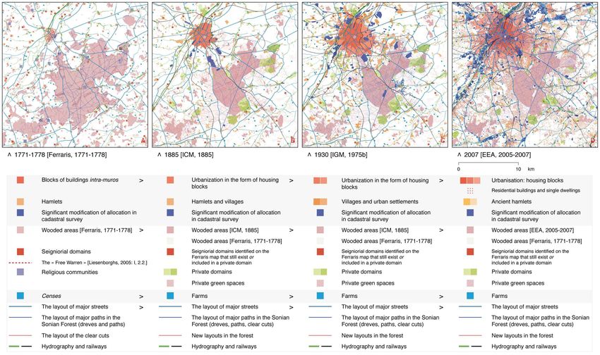
Lee Christopher ROLAND,
                                                   « When you can't see the city for the trees.
                                      A joint analysis of the Sonian Forest and urban reality »,
                           Brussels Studies, Number 60, July 2nd 2012, www.brusselsstudies.be      2
                           ban forms, lifestyle practices and physical structures. Thus, although
                           the forest constitutes one of these structures, the aim is to denounce
                           the risks of degradation which it incurs, or to argue in favour of protect-
                           ing the 'natural ramparts' which it represents with respect to 'Brussels
                           urbanisation', rather than explicitly analysing its role in the emergence
                           and evolution of a highly spread out urban fabric.
                           6. Nor is this role of the Sonian Forest highlighted as part of planning
                           tools [GW, 1999; GRBC, 2002; MVG, 2004; VR, PVB et al., 2004] or in
                           the framework of institutional mechanisms intended to make the urban
                           development of Brussels more sustainable, such as the Vlaams
                           Strategisch Gebied rond Brussel (VSGB) [MVG et al., 2008a & b] or the
                           future Plan Régional de Développement Durable (PRDD) [GRBC, 2011].
                           As demonstrated by the 'city projects' (figure 1a) and the ecological
                           networks (figure 1b) resulting from these mechanisms, the relationships
                           between the forest and surrounding areas are rarely dealt with. The
                           notion of 'edge' is not very present, as the VSGB favours the notion of
                           Groene Gordel and the PRD, that of the ecological network. The impact
                           of the forest on groundwater and surface water [VMM, 2008: 39, 53-
                           54], the way in which it regulates urban heatwaves [VITO, 2007: 7, 11;
                           Van Weverberg et al., 2008], and its socioeconomic impact on lifestyle
                           practices [Roland, 2011a: 56-59, 157] are rarely considered. In other
                           words, the wooded area is not considered as a founding element of
                           urban development.
                           7. This situation is partly linked to the Belgian institutional context,
                           which fragments the knowledge of the central part of the country.
                           However, its epistemological dimension must not be neglected. For
                           example, the reference cartographic sources and documents serving
                           as a basis for planning – in particular the Carte topographique 1: 20
                           000 [IGN, 1988-2002], the Carte d’Évaluation Biologique [Brichau et al.,
                           1997-2000 & 2000; INBO et al., 2010] and the European network Na-
                           tura 2000 [EEA, 2010] – limit the representation of the wooded area to
Figure 1. Juxtaposition    the transcription of homogeneous soil covering. This in fact constitutes
(by the author) of stra-   a reduction with respect to its geographic and ecosystemic scope. 3 In
tegic plans and regional   these representations, the forest is reified: it forms a distinct entity of
ecological network pro-    fragments of habitat, 'green spaces' and surrounding agricultural sur-
jects                      faces. At physical and biological level, these spatialities form
Lee Christopher ROLAND,
                        « When you can't see the city for the trees.
           A joint analysis of the Sonian Forest and urban reality »,
Brussels Studies, Number 60, July 2nd 2012, www.brusselsstudies.be      3
'ecotones'.4 At usage level, they direct the future of the wooded area.
8. Figures 2 and 3 – made from detailed orthophoto maps – present
the 'discrepancy' which may exist between these representations and
the configurations in situ of developed land and green areas. This type
of discrepancy may be seen in particular in the configuration of the
Special Conservation Zone of the wooded area, which was established
when it became part of the Natura 2000 network in 2007. By associat-
ing a reference spatiality with the wooded area, this spatial definition
perpetuates a specific land use designation: the wooded area. But, at
regulatory level, it also isolates the forest from its edges. If one sub-
scribes to the 'individualist hypothesis'5 of the structuring of plant
communities, this delimiting operation does not give itself the institu-
tional means for a better understanding of the evolution of the forest
with respect to its environment. In reality, it favours autonomous man-
agement methods (see figure 1), to the detriment of land use planning
projects which pay closer attention to their 'ecological' impact.6 In this
respect, figure 3 clearly highlights the overlapping of developed land
and green areas beyond the areas currently associated with the forest.
In addition to being normative, the challenge is therefore also related to
the landscape [CEE, 1992; Campbell & Reece, 2007: 1174, 1277,
1311, 1324-1325; LAFS, 2009: 104].
9. The difficulty involved in considering the forest within a pertinent
spatial extension and in taking its structuring role in urban development
into account may be overcome with a historical, anthropological and
spatial description of the wooded area and its surroundings [Geertz,
1973: 24-28, & 1998; Arnaud, 2008: 7-10; Mary, 2008]. This will be the
focus of the rest of this article.

Figure 3. Dense woody vegetation spreads beyond the Special Con-
servation Zones of the wooded area and does not exist in a similar form
in other parts of the urban area
Lee Christopher ROLAND,
« When you can't see the city for the trees.
A joint analysis of the Sonian Forest and urban reality »,
Brussels Studies, Number 60, July 2nd 2012, www.brusselsstudies.be 4
2. Defining the Sonian Forest as an ecosystem Sonian Forest constitutes the only large-scale wooded area between
the Belgian coast and the Sambre and Meuse valley, and its condition
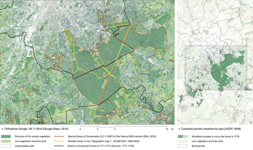
10. Describing the forest implies a prior change of scales and carto- is urban for two reasons.7 The forest is located in the area of influence
graphic codes in order to integrate the following situation (figure 4): the of the Brussels urban area as well as occupying a central position with
Figure 2 – Result of a pixel analysis highlighting the plant structures present within the area considered. Map made by the author using the software ENVI, covering an area of
about 20 x 14 km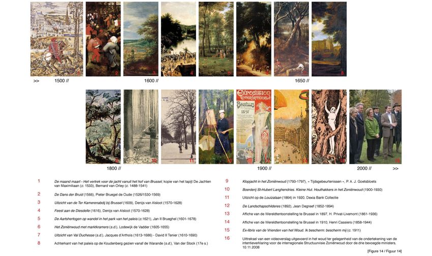
Lee Christopher ROLAND,
                                                                                                      « When you can't see the city for the trees.
                                                                                         A joint analysis of the Sonian Forest and urban reality »,
                                                                              Brussels Studies, Number 60, July 2nd 2012, www.brusselsstudies.be      5
respect to the North Western Metropolitan Area [CE, 2007: 8; INBO,            Drève de Lorraine) [Langhor, 2001: 111-112; De Vos, 2005: 37-40, 70-
2009: 69-77]. It is at the heart of a elliptic configuration delimited by      71; Daise et al., 2009: 45-47, 51-56, 345-350; Vandermotten et al.,
cities such as Antwerp, Ghent, Kortrijk, Lille-Roubaix-Tourcoing, Lens-       2012: 52-55].
Liévin, Douai, Valenciennes, Mons, Charleroi, Namur, Huy, Liège, Maas-
                                                                              14. Despite their importance, these spatial questions will not be dealt
tricht and Hasselt. Its status is not comparable to that of forests in Ar-
                                                                              with systematically. The keys to understanding them will be given
dennes and Kempen, or to that of the European beech forests situated
                                                                              through an equally fundamental perspective, i.e. that of the evolution of
in rural environments [Daise et al., 2009: 23-24]. Unlike the latter, the
                                                                              the forest over time. The current physical and sociocultural realities of
Sonian Forest does not have a large-scale ecological equivalent within
                                                                              the forest depend precisely on this evolution.
60 km of its edge [EEA, 2006; EEA, 2010]. Furthermore, it is particularly
exposed to urbanistic pressure.
11. On a Belgian scale, the Sonian Forest is thus the only wooded
area whose continuity depends on a significant number of forms of de-
veloped land – buildings as well as many mobility networks – associ-
ated with practices which have a direct impact on it. For these reasons,
its diagnosis must go beyond the strict regulatory areas in order to ob-
jectivise two dimensions: on the one hand, the spatial area of these
ecosystems and their relationship with water and soil; and on the other
hand, the impact of human activities on these ecosystems.
12. The first dimension implies an identification of the interactions be-
tween the wooded area and the valleys whose source is located there,
such as the Argentine, the Ijse and the Woluwe. It also requires an un-
derstanding of the role of the biogeochemical system formed by the
forest and Bruxellien sand 8 in the preservation of groundwater quality,
particularly that of the Lédo-Panisélien Bruxellien aquifer9 presented in
figure 4 [DGARNE, 2005: 10, 17; DGARNE, 2006: 3-13, 23-24, 27;
VMM, 2008: 12, 20-21, 24-26, 33-35, 39-40, 53-54, 68; Daise et al.,
2009 & 2011: 42-45; LAFS, 2009: 181-195; CIW & VMM, 2010: 11-12,
21, 39; DGARNE, 2010: 5, 19, 22; Langhor, 2010; Vandermotten et al.,
2012: 7-12].
13. The second dimension calls for an evaluation of the influence of
types of settlement on the forest and its ecotones, as regards 'local'
uses (leisure activities, farming methods, residential landscaping, con-
figuration of drainage networks, building practices, geothermal science,
etc.), as well as in terms of infrastructure projects (RER, widening of the
ring road, development of the Delta pole, future of the Auderghem via-
duct, reorganisation of traffic at Bois de la Cambre - Avenue Louise -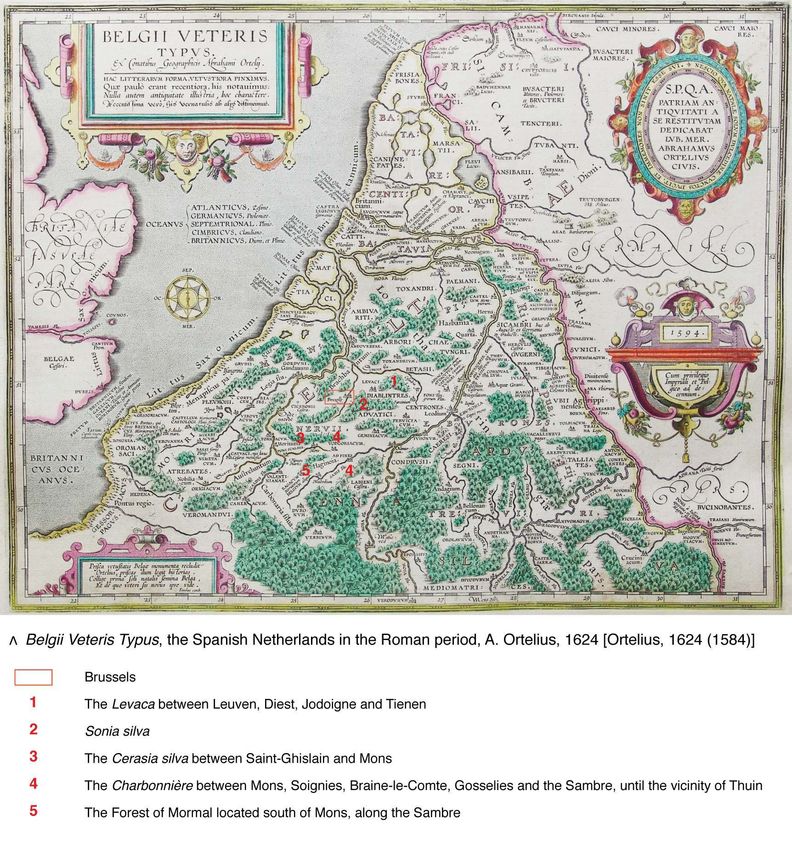
Lee Christopher ROLAND,
                                                                                                              « When you can't see the city for the trees.
                                                                                                 A joint analysis of the Sonian Forest and urban reality »,
                                                                                      Brussels Studies, Number 60, July 2nd 2012, www.brusselsstudies.be      6

Figure 4. Three scales highlighting the spatial condition of the Sonian wooded area
Lee Christopher ROLAND,
                        « When you can't see the city for the trees.
           A joint analysis of the Sonian Forest and urban reality »,
Brussels Studies, Number 60, July 2nd 2012, www.brusselsstudies.be      7
3. The Sonian Forest plateau: an 'upstream/downstream' asym-
metry in the emergence of Brussels urban reality (11th – 18th
centuries)

15. In order to understand the physical reality of the area concerned,
we must go back to at least10 the Carolingian period, when a vast area
called the 'coal forest' was divided up following several clearing opera-
tions. It was during this period that the name Sonia silva (Sonian Forest)
appeared, indicating the appropriation of this area by a series of human
establishments. Figure 5 provides an idea of the area of the forest be-
fore this individualisation. At the time, it covered all of the south of
Brussels as well as almost all of the plateau separating the Zenne from
the Dijle, including Halle Wood and Forest Wood [Duvivier, 1861: 12-13;
Pierron, s.d.: 8-9, 12; LAFS, 2009: 10-16, 64-65, 183-184; Byl et al.,
2010].
16. This dividing up was synonymous with an increase in practices
related to the forest. It was accompanied by an increase in forms of
developed land on its outskirts, either along the existing edge, or in
extensions made due to clearing for agricultural purposes or for devel-
opment. Among these forms, several hamlets were established. The
oldest date from the 10th century (Tervuren, Uccle, Overijse, Water-
mael); most of the others appeared between the 12th and 13th centu-
ries. They were next to a large number of censes (land subject to quit-
rent)11 situated in direct proximity of the wooded area, and from the
12th century, were near religious or seigniorial areas, some of which
were located in the middle of the forest. The presence of these areas
was therefore closely related to the domination of the Dukes of Bra-
bant. The Sonian Forest was declared 'property of sovereigns' until
1794 12 [Ferraris, 1771-1778; Pierron, s.d.: 11-12; LAFS, 2009: 10;
Jaumain et al., 2009: 71; Vandermotten et al., 2012: 20, 77-80, 94-
100, 102-103, 139-142].
17. These elements are still perfectly identifiable on Ferraris’ map (fig-
ure 6). They indicate the importance of the wooded area until the end of

Figure 5. The gradual dividing up of the 'coal forest'; situation during
the Roman period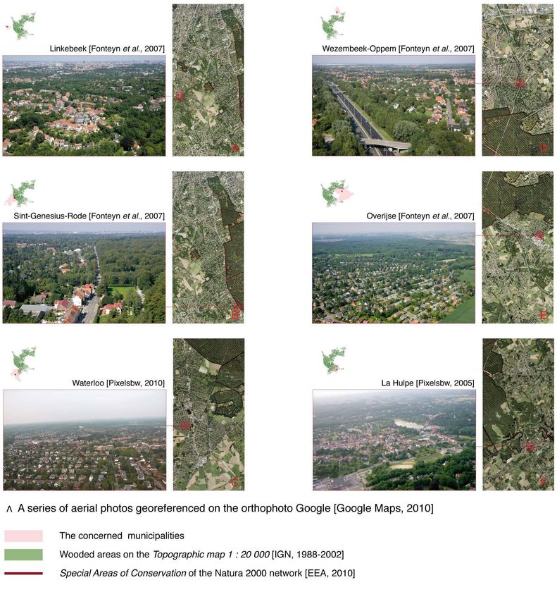
Lee Christopher ROLAND,
                                                                                                                                  « When you can't see the city for the trees.
                                                                                                                     A joint analysis of the Sonian Forest and urban reality »,
                                                                                                          Brussels Studies, Number 60, July 2nd 2012, www.brusselsstudies.be      8

Figure 6. Spatialisation of practices and of developed land in the territory considered during the second part of the 18th century
Lee Christopher ROLAND,
« When you can't see the city for the trees.
A joint analysis of the Sonian Forest and urban reality »,
Brussels Studies, Number 60, July 2nd 2012, www.brusselsstudies.be 9
the Ancien Régime. For the people who lived on the outskirts – includ-
ing the inhabitants of Brussels – it represented a source of fuel, con-
struction materials and food, in addition to playing a part in agricultural
practices. For the seigniorial and religious authorities, it constituted an
essential source of revenue, as well as a place of recreation and pomp,
where hunting activities were held [Pierron, s.d.: 225-233; Liesen-
borghs, 2005; LAFS, 2009: 10-16, 51-54; Vandermotten et al., 2012:
17-20].
18. For purposes related to subsistence, production and representa-
tion, the uses which developed in the south/southeast of Brussels dur-
ing this period were therefore not of the same nature as those which
existed in the west and north of the city. Their spatialisation and the
artefacts which they produced – road networks, buildings, parks and
warandes (game preserves) 13 – must be considered according to three
observations: as regards the collective imagination, the forest was a
landscape construction14 whose representation illustrated social prac-
tices (see figure 14); at functional level, it was a resource which was
made accessible via a network of roads and drives which ran through
it; 15 in terms of management, it was the property of the sovereign
authority who could decide on its use [Smolar-Meynart, 1998: 33, 36-
37, 118-119; Van de Kerckhof et al., 2000: 274].
19. This three-sided situation is not neutral. It signifies that, for the
population of Brussels as well as for the authorities who lived there, the
territories outside the town were not considered to be isotropic; the
borders of the Duchy of Brabant, the ties with Leuven, the Sonian For-
est and the physical boundary formed by the alluvial plain of the Zenne
were factors which went against purely radioconcentric territorial dy-
namics. In terms of proto-urbanisation, the distribution of forms of de-
Figure 7. As an element
veloped land to the east of the Zenne was thus determined as much by
which intervened in the
a particular geopolitical and sociocultural situation – that of a ducal for-
power relationships
est situated upstream from an urban settlement, both of which were
between urban stake-
under the control of the same authority – as it was by the physical ex-
holders, the forest
tension of the city from its centre outwards.
caused asymmetry in
terms of the distribution 20. The forest also played a role in the emergence of certain morpho-
of territorial dynamics logical specificities of the Pentagon inherited from the Ancien Régime,
very early on for three reasons: firstly, the topography facilitated the leading of theLee Christopher ROLAND,
« When you can't see the city for the trees.
A joint analysis of the Sonian Forest and urban reality »,
Brussels Studies, Number 60, July 2nd 2012, www.brusselsstudies.be 10
forest towards Brussels; secondly, the forest represented the very ma- were eliminated, trees were planted in the 'naturally' empty spaces, and
terial with which the urban settlement was built (from a material, eco- the existing trees were replaced – most often by beech – in order to maxi-
nomic and political point of view); thirdly, it monopolised the access mise exploitation. These transformations – which were particularly intensive
within its territory to the main network allowing the transport of this re- from the 16th century onwards – resulted in works being carried out from
source, i.e. the Zenne as well as the Willebroek Canal (1561). As figure the beginning of the 18th century in a forest which was highly regulated by
7 suggests, the development of the central urban fabric was therefore man: the 'even-aged beech forest'. From this moment on, young beech
not purely endogenous; it integrated the relationships with the forest trees were grown in nurseries (in particular on the former domain of the
[Jaumain et al., 2009: 53]. The asymmetry generated by this is sug- Rouge-Cloître), and were then planted in the forest where they were the
gested by place names such as Hout kaye, Hooy kaye, and de Hout object of artificial selection, all according to an exploitation method referred
merckt Straet, and by the continued presence of a wood market in to as 'unstopped clear-cutting'18 [Pierron, s.d.: 96-129, 147-168, 243-247;
Brussels from the 15th to the 19th century. But it is apparent above all Mortier & Hasquin, 1997: 19-20; LAFS, 2009; Vandermotten et al., 2012:
physically in the forms of developed land. For example, figure 7 pre- 4].
sents the relationships between the former Coudenberg warande (cur-
22. This management method, used throughout the wooded area from
rent Brussels Park) and the coppices in the northwest of the Sonian
1788 until the beginning of the 20th century, homogenised the wooded
Forest, as well as the importance of uses and practices along the
area. Furthermore, it increased its surface area. Its reason for being was
walsche weg (see notes 12, 14, 16 & 23). It also allows an evaluation of
nevertheless economic and strategic, bearing witness to the power rela-
the northwest/southeast orientation of the routes inside the city – in
tionships which existed. The abovementioned notion of asymmetry was a
particular the Steenwech 16 – organised around the hub represented by
way to translate the geopolitical reality which prevailed from the 12th to the
Bassin des Marchands (1561) and Bassin Sainte-Catherine (1564) for
18th century – that of a coalition of urban stakeholders determined by two
several roads linking the Sonian Forest and Willebroek Canal. In this
complementary and opposing polarities: the city and the forest. As sug-
respect, let us mention the perpendicularity of the tree felling areas with
gested by centering and areas shown on many old maps [Van Werden,
respect to these roads – an explicit sign of practices which developed
1659; Ferraris, 1770; Pierron, s.d.: 21, 89], in terms of geographic area,
between the uphill slope and the downhill slope of the valley [Fricx,
this reality goes well beyond the inner city of Brussels. It shifts the centre of
1712; Henne & Wauters, 1845: 303, 528-529; Ducpetiaux, 1847: 90;
gravity of the Pentagon to the southeast, with its evolution directly linked to
Smolar-Meynart, 1998: 33; Jaumain et al., 2009: 72].
this hinterland. Thus, during the Ancien Régime, this part of the current
21. The role played by the forest in terms of territorial dynamics did not urban area must be seen as the fruit of a territorial coproduction, rather
necessarily serve the urban authorities: the forest belonged to the sover- than the product of independent stakeholders [Pierron, s.d.; LAFS, 2009;
eigns; its status was therefore not similar to that of the territories which Jaumain et al., 2009: 71-72].
constituted the 'Cuve de Bruxelles' (from the 13th century until 1795). This
was not a negotiated resource which the city used freely – it was the object
of a right of passage from the 15th to the 18th century – but rather one of 4. Silent subtraction: the privatisation of the wooded area on the
the guarantees of seigniorial power. From the 14th century, the seigniorial eve of urban expansion (end of the 18th century/beginning of
power established several means to preserve the integrity of the wooded the 19th century)
area and to enhance its value. 17 The forest 'was built' as much as the city
itself, with its facies becoming less and less spontaneous. It was gradually 23. This coproduction and the relative preservation of the wooded
marked out and sloped parallel to its property boundaries, the roads which area which it established were questioned at the beginning of the 19th
went through it were cobbled and levelled, the composite forest systems century, when a political crisis placed the sovereign authority – an age-Lee Christopher ROLAND,
« When you can't see the city for the trees.
A joint analysis of the Sonian Forest and urban reality »,
Brussels Studies, Number 60, July 2nd 2012, www.brusselsstudies.be 11
old owner of the forest19 – in a difficult situation. In this context, the
process of rationalisation of forest 'management' and exploitation be-
gun during the previous centuries suddenly became synonymous with
significant reductions in the surface area of the forest. As the authority's
social status had been lowered, the forest no longer had any influence
at political level, and only its financial value counted from that point on-
wards.
24. The premise for this change in regime goes back to 1822, when
William I sold the property of the Sonian Forest to a public limited com-
pany of which he was a shareholder: the Algemeene Nederlandsche
Maatschappij ter Begunstiging van de Volksvlijt (ANMBV).20 Officially,
this transfer of wood capital contributed to reducing the public debt
incurred during the Napoleonic Wars. Unofficially, in a context of politi-
cal instability, it brought the capital represented by the property belong-
ing to a private estate back to the sovereign, until 1834, when the
ANMBV – which had become the Société Générale pour favoriser l'in-
dustrie nationale during Belgian independence – asserted its national
character. On the eve of the mechanised industrialisation of the Belgian
territory and in an institutional context favouring financial precarious-
ness, the forest therefore became dependent on a regime which was
relocated with respect to Brussels, where the rationality of its configura-
tion was purely synonymous with profit [Maziers, 1994; Corvol, 1995:
704; Kurgan-van Hentenryk, 1997 (1996): 21-26, & 1998; Tallier, 2002:
1248-1252, 1261; LAFS, 2009: 10-15, 17-18, 58].
25. This silent subtraction of the 'forest entity' with respect to Brussels
dynamics deeply transformed the physical structure of the area situated
to the south/southeast of the Pentagon. From 1825, it brought about
an administrative division of the wooded area in order to implement the
collection of a tax. 21 As shown in figure 8a, the 'triages' – pre-existing
territorial areas linked to the surveillance of forest officers – were en-
trusted to municipalities which, until then, had bordered the former du-
cal property. Beyond its impact in terms of forest management (see
Figure 8 – The impacts of the change of status of 1822 on the property
of the wooded area and its spatial location in the Antwerp-Brussels-
Charleroi routeLee Christopher ROLAND,
« When you can't see the city for the trees.
A joint analysis of the Sonian Forest and urban reality »,
Brussels Studies, Number 60, July 2nd 2012, www.brusselsstudies.be 12
note 22), this administrative reconfiguration thus established the future tion of the Sambre and the port of Antwerp infrastructures [Maziers,
institutional power relationships between the city of Brussels and its 1994; Jaumain et al., 2009: 93].
outskirts, on the eve of the expansion of the central urban fabric [LAFS,
28. These extralocal spatial determining factors also deeply modified
2009: 77-78; Vandermotten et al., 2012: 4].
the reality in situ: in the short term, they completely changed the exist-
26. Furthermore, the alienation of 1822 led to the creation of the ing landscape structures, and in the long term, they directed develop-
Route de la Banque (1833). By crossing the forest to connect Chaus- ment outside Brussels for several decades. In 1842, when the forest
sée de Charleroi and Chaussée de Malines, it formed a new route situ- was returned to the Belgian state (in the framework of the financial
ated on the ridge line separating the catchment area of the Zenne from regulation following the breaking up of the kingdom of the Netherlands),
that of the Dijle. Contrary to the roads, this route – represented in figure the latter recuperated only 4,386 of the 11,718 hectares of the former
8 – was no longer intended for the Pentagon: on the one hand, it property belonging to a private estate (see note 21). A large part of the
opened up the industrial activities of the region of Charleroi where the forest surface area had therefore been divided into plots, sold, cleared
Société Générale continued to invest [Trioen, 1839]; on the other hand, and then converted into farmland or large private properties. It was
it maximised the access to the southern part of the wooded area, more precisely these pieces of land and these properties, such as Linthout
precisely to a series of wooded plots of land which the Société sold in wood and Mesdael wood, Mangelingenbosch, Solbosch, Streek Veld,
large numbers, between 1831 and 1836 (before its 'voluntary nationali- Stockel and Heeghde22 (figure 9), as well as certain sites inherited from
sation' through the repurchase of securities held by William I), to mem- the Ancien Régime or purchased (in particular between 1819 and 1821)
bers of the business upper middle class. Figures 12b and 12c indicate through the confiscation of church property (mainly in 1796), which nur-
in this respect the reduction in forest routes and paths in the southern tured the speculative logic specific to the process of urbanisation. Fol-
part of the forest in the 19th century. Furthermore, they illustrate the lowing the transformations which made the physical and political ex-
acquisition of private areas in the remains of the ducal forest, in particu- pansion of the city of Brussels possible,23 these plots of land repre-
lar that of the de Meeûs family in Ohain (1833, 1836), the de Béthune sented not only a pool of land for the young capital, but above all a fi-
family in La Hulpe (1833), the Coghen family in Uccle (Wolvendael cas- nancial capital to add value for the investors who supported its devel-
tle, 1829), the Bischoffsheim family (purchased by the Vanderhecht opment [Wauters, 1855: 11; Corvol, 1995; Tallier, 2002: 1245; Jaumain
widow in 1832 and resold to the said family in 1848) and the Verhaegen et al., 2009: 281; LAFS, 2009: 17, 58, 77-78; Zitouni, 2010: 70; Van-
family (future Tournay-Solvay property) in Watermael-Boitsfort [IGM, dermotten et al., 2012: 4-6].
1975 (1858); Kurgan-van Hentenryk, 1997 (1996): 21-26, 112; Tallier,
2002: 1267-1269, 1271-1274; Verwilghen, 2006: 21-22, 70-72, 75-76;
LAFS, 2009: 24; Vandermotten et al., 2012: 55, 60, 124]. 5. The great coalition: the Sonian Forest at the heart of political
and financial deals of the new Belgian state (19th century)
27. The change in status of the wooded area was therefore both insti-
tutional and spatial (figure 8). The forest – formerly linked to its nearby
29. Under the influence of economic, political and urbanistic logics, as
outskirts and in particular to the east side of the Zenne – was from then
well as due to the very nature of programmes requiring significant land
on part of the Antwerp-Brussels-Charleroi route, which was material-
assembly, 24 the occupation of forest surface areas from 1822 by forms
ised by the prolongation of the canal (1832) and by the creation of the
of developed land began in the second half of the 19th century. It was
Brussels-South/Charleroi-South railway line (1843-1873). The profits
permitted by two urbanistic operations: the Léopold quarter (1837) and
generated by the sale of these areas were used to finance the canalisa-
Avenue Louise (1861-1862). The first involved the former coppices of
the forest situated near the Pentagon; the second 'sought' the formerLee Christopher ROLAND,
« When you can't see the city for the trees.
A joint analysis of the Sonian Forest and urban reality »,
Brussels Studies, Number 60, July 2nd 2012, www.brusselsstudies.be 13
Heeghde which had been cleared at the time, more precisely a piece of
land given to the Belgian state in 1843 by Léopold I: the future Bois de
la Cambre (1864-1865) [Jaumain et al., 2009: 40, 112-113; Vander-
motten et al., 2012: 34, 35, 65, 83, 106].
30. As regards these operations, the land transfers which took place
at the beginning of the century acquired a special value. Two hypothe-
ses – presented in figure 9 – are worth mentioning:
31. In the case of the Léopold quarter, the challenges related to the
political extension of the city of Brussels (mainly in 1853) met the ambi-
tions of large middle-class families, anxious to go beyond the Maelbeek
valley to enhance the value of the land which they had acquired from
the Société Générale. The establishment of the new quarter near Sol-
bosch, Mesdael wood and Linthout wood was not innocent. On the
one hand, the shareholders of the company in charge of the develop-
ment of the neighbourhood – the Société civile pour l’agrandissement
et l’embellissement de la capitale de la Belgique (1837) – included the
representatives of these families whose financial capital was sometimes
made up of these very sites. On the other hand, this company –
founded by Ferdinand Meeus – was a subsidiary of the Société Géné-
rale, a company which the latter managed from 1830 to 1861 and of
which these families were shareholders 25 [Wauters, 1855: 11; Witte,
1969: 6-47; Kurgan-van Hentenryk, 1997 (1996): 26-36; Tallier, 2002;
MRBC-DMS, Berckmans & Genon, s.d.: 9, 11; Jaumain et al., 2009:
91, 112, 218].
32. In the case of Avenue Louise, beyond the real estate operation
Figure 9. The connec- whose value was enhanced by the creation of Bois de la Cambre and
tions between the first its promenade, it was an occasion for the city of Brussels to acquire a
urbanistic develop- rare and contested resource with respect to galloping urbanisation, i.e.
ments outside the city the drinking water present in the ground of the Sonian Forest. The po-
and the plots of land litical annexation of the avenue and the park in 1864 were thus followed
from the Sonian For- by the first water collection in the Sonian Forest in 1873 (law of 8 June
est, in particular Hee- 1875) [ICM, 1879; Ranieri, 1973: 31-33; Pierron, s.d.: 8-9; MRBC-
ghde, Solbosch, DMS, Douillet & Schaack, s.d., a & b; LAFS, 2009: 197; Jaumain et al.,
Mesdael wood, Man- 2009: 91].
gelingenbosch and
Linthout wood 33. More than the first urbanistic tools 26 [Zitouni, 2010: 122-125, 134-Lee Christopher ROLAND,
« When you can't see the city for the trees.
A joint analysis of the Sonian Forest and urban reality »,
Brussels Studies, Number 60, July 2nd 2012, www.brusselsstudies.be 14
136], and behind the arguments linked to the landscape and sociocul- 6. Appropriation of outskirts 'on the outskirts': Sonian Forest
tural value of the forest – as was the case during the creation of Bois de land and the productivist system elite (end of the 19th century –
la Cambre – the political and financial interests of a limited number of 20th century)
protagonists therefore appeared to direct the development of the urban
fabric in the 19th century. These interests – determined by the land as- 35. At the beginning of the 20th century, the major roads in the Léo-
sets acquired through the sale of the Sonian Forest – may be seen as pold quarter and Avenue Louise – fortified by these first establishments
factors which reinforced the geopolitical asymmetry which had existed – were transformed into true development priorities. Within a few dec-
several centuries earlier. The city and the forest were no longer oppos- ades, they connected the central urban fabric with the land with devel-
ing polarities in power relationships, but rather two elements which opment potential situated on the outskirts of the wooded area (figures
served the intentions of a coalition of hegemonic stakeholders who had 10, 11 & 12). This change was deeply influenced by the aims of Léo-
helped themselves to a geographic area which went beyond the physi- pold II in terms of planning and real estate promotion (figure 15). Let us
cal boundaries of the urban fabric. It is therefore not surprising that this also mention that it also took advantage of the historical location of
asymmetry was evident in the spatial distribution of the developed land roads, the theories of garden cities, 27 international exhibitions (1880,
outside the city, which had a stronger presence to the south/southeast 1897, 1910), the railway and tramway network (extended between
of the Pentagon until the middle of the 20th century (figure 11a) [Deje- 1869 to 1952), and the emergence of forest tourism among large sec-
meppe et al., 2012: 21]. Furthermore, inasmuch as it involved attracting tors of the population [Ranieri, 1973: 21, 24, 71, 88, 112, 343, 353-
creditworthy buyers to the former edges of the wooded area, it is likely 356; Jaumain et al., 2009: 39, 90-91, 98, 286, 306; LAFS, 2009: 36-
that it asserted conclusively the process of social dualisation which 37; Zitouni, 2010: 220-223; Vandermotten et al., 2012: 20-28].
characterises Brussels today [Van Hecke et al., 2009: 153-155, 170-
36. As regards the abovementioned graphic documents, the main
171].
lines of this change may be summarised as follows:
34. In reality, these hypotheses were first confirmed by the northeast
37. A first route, 28 in the east, established the densification of upper
extension (1875) of the Léopold quarter, by the establishment of
parts of Schaerbeek and Etterbeek around Rue de la Loi, Avenue de
middle-class populations from Ixelles and Saint-Josse in the Maelbeek
Cortenberg and Avenue d’Auderghem. That of the two Woluwes,
valley and by the major roads built by Georges Brugmann to enhance
Stockel, Kraainem and Tervuren was then begun via Avenue de Ter-
the value of land in Saint-Gilles, Forest and Uccle. It was then corrobo-
vuren through the forest (1896-1899). Beginning at the Royal Park
rated at the turn of the century by the movement of middle-class resi-
(1775-1780), it joined the northeast part of the forest via Avenue de
dential homes to the north/northwest edge of the forest and by the
Tervuren – more specifically the royal area of Tervuren – and it joined
gradual urbanisation of the former Heeghde (Langeveld, Vert Chas-
several sites with a monumental and recreational vocation: the Cin-
seur), Linthout (George Henri neighbourhood), part of the Mesdael, and
quantenaire (1888), the parks – Woluwe, Parmentier and Étangs Mel-
the upstream part of the Woluwe valley (Watermael-Boitsfort, Woluwe-
laerts (1887-1899, 1906) – and the Ravenstein golf club (Belgian Royal
Saint-Pierre, Woluwe-Saint-Lambert) [MRBC-DMS, 2005-2007; ICM,
Golf Club) [Ranieri, 1973: 77-98, 124; Jaumain et al., 2009: 302-304;
1885; ICM, 1879; ICM, 1904; Ranieri, 1973: 66, 70; MRBC-DMS, Herla
Vandermotten et al., 2012: 106, 107].
& Deschaumes, 2007; Jaumain et al., 2009: 43, 196, 218, 285, 357-
359, 363; Zitouni, 2010: 53-96]. 38. A second route,29 in the southeast, led to the urbanisation of Ix-
elles and Saint-Gilles around Avenue Louise. It then led to that of Aud-
erghem, Forest, Uccle, Watermael-Boitsfort and La Hulpe via two op-
erations: on the one hand, its prolongation towards Avenue de Ter-Lee Christopher ROLAND,
« When you can't see the city for the trees.
A joint analysis of the Sonian Forest and urban reality »,
Brussels Studies, Number 60, July 2nd 2012, www.brusselsstudies.be 15
Figure 10. Three views on the morphogenesis of the area considered, from the end of the 18th century until the 21st centuryLee Christopher ROLAND,
« When you can't see the city for the trees.
A joint analysis of the Sonian Forest and urban reality »,
Brussels Studies, Number 60, July 2nd 2012, www.brusselsstudies.be 16
Figure 11. The south/ vuren, with the creation of Avenue de la Vénerie, Boulevard du Sover- ruling classes. The continuity which the two avenues established be-
southeast process of eign (1901-1910) and Avenue des Nations (1922); on the other hand, tween the Tracé Royal,31 an extension of Rue de la Régence (1927)
diffusion of the resi- the establishment of by-road W to Braine-l'Alleud and Wavre, 30 and the (figure 9), and the drives in the wooded area – which were open to car
dential environment asphalting of Drève de Lorraine (1925). In the same way as in the east, traffic32 – made a north-south crossing of the city possible, from the
during the 20th cen- these operations were once again polarised by part of the forest: Bois area of Laeken to the east and south edges of the forest, via a succes-
tury de la Cambre [Ranieri, 1973: 70, 103-113; MRBC-DMS, Herla & De- sion of tree-lined boulevards which skirted round the working-class
schaumes, 2007; MRBC-DMS, Douillet & Schaack, s.d., a, b & c; neighbourhoods of the Pentagon. In the long term, these routes estab-
Jaumain et al., 2009: 315; LAFS, 2009: 36-37]. lished a territory33 which was historically dedicated to the 'elite'. This
secured the land acquisitions of these stakeholders – in particular those
39. By establishing a direct connection between the Pentagon, the
of Léopold II, whose properties are presented in figure 15. Furthermore,
boulevards of the ring and the historical location of roads (Chaussée de
they inaugurated new relationships with the central urban fabric, which
Waterloo, Chaussée de La Hulpe, Chaussée de Wavre and Avenue de
was from then on 'avoided', both in terms of practices as well as from a
Tervuren), these two routes eventually integrated the hamlets which
morphological point of view. The establishment of the racecourses in
were historically located on the outskirts of the forest into urban dynam-
Boitsfort (1875) and Groenendael (1888), and the Ravenstein golf club
ics (see figures 7 & 10a). Furthermore, they played a special role for the
(1904-1906) were revealing in this respect [Ranieri, 1973: 77-98, 101-Lee Christopher ROLAND,
« When you can't see the city for the trees.
A joint analysis of the Sonian Forest and urban reality »,
Brussels Studies, Number 60, July 2nd 2012, www.brusselsstudies.be 17
Figure 12. Synthesis of morphogenesis of the area considered, from the end of the 18th century until the 21st centuryLee Christopher ROLAND,
« When you can't see the city for the trees.
A joint analysis of the Sonian Forest and urban reality »,
Brussels Studies, Number 60, July 2nd 2012, www.brusselsstudies.be 18
102; Pierron, s.d.: 12, 168-171; Verwilghen, 2006; Jaumain et al., with post-war Fordism favouring the creation of single-family housing
2009: 83, 154; Vandermotten et al., 2012: 20-23, 43]. estates and large housing developments on the outskirts of the urban
centre. 35 Beginning in 1950, the major housing development operations
40. In the 20th century, the two abovementioned radial components
– mainly those devoted to single-family dwellings – thus went beyond
therefore had a major influence on the nature of the territory and on the
the current regional boundaries, but still on the outskirts of the Sonian
way it grew in density. As both causes and consequences of the south/
Forest. This irremediably created an asymmetrical distribution of forms
southeast movement of diffusion of the residential environment, their
of developed land in the urban area (figures 11 & 12), often coupled
impact was the result of a three-sided situation. At sociocultural level,
with a difference in social status of the populations [Dubois, 2005; Cas-
they responded to the desire to be close to 'nature', which was felt to
siers & Denayer, 2009; MRBC-AATL et al., 2010a, b & c; Dejemeppe et
be healthier and more comfortable than the urban centre (which was
al., 2012: 22-25].
congested and poor). This 'nature' was partly embodied in the forest
landscape. At economic level, they made the vast pieces of land which
had been sold during the previous century by the Société Générale34
7. The cultural determining factors of naturalisation (end of the
accessible and appealing. At political level, they were directly in keeping
19th century – 20th century)
41. While the forest determined the evolution of urban reality, in return
the latter had a deep impact on the construction of the forest land-
scape and its management. The physical configuration of the forms of
developed land led to modifications in the flora and the forest soil, and
therefore in the water regimens associated with them. City practices
also modified the way the forest was viewed [Larrère, 2009 (1997):
203-206; IBGE et al., 2009: 31; Van Hecke et al., 2009: 167; Roland,
2011a: 56]. For example, while it was managed for production and
profit purposes in the 18th and 19th centuries, in 1907, the gradual
colonisation of its edges tolled the knell of unstopped clear-cutting, with
the large clearings perceived by walkers as being 'unsightly' – in par-
ticular the landscape painters of the Rouge-Cloître and Tervuren [LAFS,
2009: 51-61, 181-209; Vandermotten et al., 2012: 99].
42. A new transformation of the wooded area and its representation
took place alongside urbanisation (figure 13). It was characterised by
the 'construction' of a 'more natural' forest, i.e. more picturesque, more
irregular, less dense and more diversified, with areas of spontaneous
sowing being reintroduced. This transformation was begun in 1886 with
the introduction of progressive group felling of a selective nature,36 and
then was applied to the entire wooded area in place of the former man-
Figure 13 – Illustration of the change in the way the forest was viewed during the process of ur- agement method. It led to a decrease in forest exploitation – as the
banisation planting method no longer lent itself to this – as well as to a questioningLee Christopher ROLAND,
« When you can't see the city for the trees.
A joint analysis of the Sonian Forest and urban reality »,
Brussels Studies, Number 60, July 2nd 2012, www.brusselsstudies.be 19
of the cathedral-like beech forest itself, with the lapse of time between 44. Afterwards, with the regionalisation of competences in the areas of
felling set at 100 years in 1788, 120 years in 1886, 180 years in 1975 the environment, urbanism and land use planning – which, from 1974
and 200 years in 2003. The suppression of large-scale felling and the to 2001, authorised more and more differentiated policies in these ar-
resulting delay of the age of felling led to the ageing of the beech forest eas in the territory of the Regions [Vandekerkhove et al., 2007] – this
[INBO, 2011: 22-23]. It therefore tended to diversify spontaneously, to change of status became more pronounced, to the point that in certain
the detriment of the homogeneous and regular facies established in the respects it became synonymous with a disinterest in the role of the for-
18th century. In this respect, the comparison of the routes in the forest est in the construction of urban reality. It was considered as a 'natural
in 1930 and 2007 (figures 12c & 12d) illustrates the shift from exploita- oasis' whose tripartite management since 1983 37 was confined to three
tion to recreation [Daise et al., 2009: 356-357; LAFS, 2009: 33-42, 51- Natura 2000 administrative areas, each under the remit of a regional
61, 105, 213-218; Vandermotten et al., 2012: 20-25]. authority' [LAFS, 2009: 73-79]. The projects and the studies which fo-
cused more or less on the wooded area led to a multiplication of partial
43. This transformation was closely linked to groups of stakeholders –
and biased interpretations, in particular when their only referents were
in particular the Touring Club (1896) and the Ligue des Amis de la Forêt
the areas of political action in the evaluations which they carried out.
de Soignes (1909) – whose positions and aims were explained by the
Three types of pitfall may thus be pointed out: the methods of evalua-
evolution of the social and political situation: firstly, the implementation
tion and the operational frameworks of management tools [GRBC,
of universal suffrage and the '1944 social pact'; and secondly, the
IBGE et al., 2003: 55-56, 100-109; Declercq, 2008; Daise et al., 2009:
community tensions and the process of regionalisation of the country.
289-392; VR, 2009a: 18-21, & 2009b], the absence of a coordination
But it must also be considered alongside the social dualisation which
of plans – in particular those determining land use [GW, 1977-1987;
accompanied the asymmetrical development of forms of developed
VR, 1972-2002; GRBC, 2001; MRBC-AATL et al., 2010a] – and the
land in the 20th century. Thus, in 1959, when a listed status prevented
lack of interest in the physical and historical reality of the territory in
any reduction in the forest surface area inherited in 1842 (i.e. 4,386
terms of representation [AGIV, 1996-2000; AGIV, 2000; VR, 2008: 30-
hectares, in other words the former ducal property reduced by about
35, Kaart 5; Dejemeppe et al., 2012: 73-75]. The first two lie within the
7,000 hectares of forest), it of course represented an ecological chal-
scope of institutional determinism; the third, within that of the normativ-
lenge, but perhaps it was also the sign of a (physical and cultural) ap-
ity of reasoning.
propriation of the forest by the people who lived in its outskirts. Al-
though this listing was established for preservation purposes, at legal
level, it above all legitimised the privatisation of the forest edges which
took place during the 19th and 20th centuries, preventing any public
intervention in terms of their future and their management. The 'natu-
ralisation' of the wooded area begun during the previous century there-
fore played a special role: beyond the concerns regarding the land-
scape, aesthetics and the environment, it above all contributed to rein-
forcing the difference in status between the wooded area and its pri-
vately owned edges; it redefined the boundaries of 'the city' and 'na-
ture' within public action [Secchi, 2006 (2000): 23; Corvol, 2005: 279-
287; Cassiers & Denayer, 2009; LAFS, 2009: 11; Vandermotten et al.,
2012: 20-26; Vandekerkhove et al., 2007, 30-31].Lee Christopher ROLAND,
« When you can't see the city for the trees.
A joint analysis of the Sonian Forest and urban reality »,
Brussels Studies, Number 60, July 2nd 2012, www.brusselsstudies.be 20
Figure 14 – The staging of the forest – a theatre for the evolution of social practicesLee Christopher ROLAND,
« When you can't see the city for the trees.
A joint analysis of the Sonian Forest and urban reality »,
Brussels Studies, Number 60, July 2nd 2012, www.brusselsstudies.be 21
Conclusion: the lessons drawn from a 'thick description', bring-
ing together the forest and urban reality
45. The south/southeast of the Brussels urban area cannot be sum-
marised as being the radioconcentric expansion of the central fabric
[Eggerickx & Poulain, 1990; Thisse & Thomas, 2010: 16], or as being a
'material expansion of the urban area beyond an initial boundary' [Lus-
sault, 2007: 333]. It is rather the sum total of nuclear developments
which were historically polarised by the forest in an endeavour by sev-
eral stakeholders to enhance its value at sociocultural, political and
economic level. This increase in value took place through spatial and
urbanistic interventions which were conceptually associated with 'the
city'. But it was always based on the control of a geographic area
which went well beyond the latter. With the landscape and the physical
structures associated with this area – i.e. the forest – having deter-
mined the urban forms, it is no longer entirely appropriate to speak of
'outskirts' or 'periurbanisation'. Technical progress and the democrati-
sation of transport associated with industrial modernity are not enough
to explain the asymmetrical distribution of developed areas – an asym-
metry present despite the relatively isotropic network made up of rail-
way networks at the beginning of the 20th century 38 [Secchi, 2006
(2000): 74-75; Lussault, 2007: 333-337].
46. Urban reality and the forest ecosystem were not 'unities with their
own balance and self-regulation' [Campbell & Reece, 2007:
1322-1325]. Everywhere at a distance of 1 to 2 km beyond the current
forest conservation areas, more or less old forest remains mixed with
artefacts, while within these areas, the structure of plantings differed
from the edges towards the central parts. How was it possible to guar-
antee the validity of environmental policies which were not linked to
urban practices, apart from proving that acidification, eutrophication,
the loss of ecotopes, desiccation, compaction and insularisation were
problems which were endogenous to the forest [Latour, 1997 (1991):
10-14, 192-197; Larrère, 2009 (1997): 139-164, 172-183; Defloor et
al., 2000: 25, 30; AGIV, 2000-2001; Langhor, 2001: 113-114, & 2010:
13-14; Feltz, 2003: 24; AGIV, 2005; Lussault, 2007: 19-20; INBO,
2009: 133-137]?
Figure 15 – The emergence of the urban area over three centuries and the role played by Léo-
pold II's interventions (1865-1896)You can also read