WOODLAND COMPREHENSIVE PLAN 2016-2036 - EZview
←
→
Page content transcription
If your browser does not render page correctly, please read the page content below
WOODLAND COMPREHENSIVE PLAN 2016-2036
ACK N OW L ED G E M EN T S
Mayor                                                 City Staff

  Will Finn                                              Amanda Smeller,
                                                         Community Development Planner
  Grover Laseke (former)
                                                         Bart Stepp, P.E. Public Works Director
City Council
                                                         Mari Ripp, City Clerk Treasurer
  Jennifer Heffernan, Position #1
                                                         Phillip Crochet, Chief of Police
  Al Swindell, Position #2
                                                         Gina Anderson, Deputy Clerk Treasurer
  Marilee McCall, Position #3
                                                      Prepared by:
  Karl Chapman, Position #4
                                                           E2 Land Use Planning Services, LLC
  Susan Humbyrd, Position #5
                                                           with JET Planning and
  Benjamin Fredricks, Position #6                          Sally Heppner Design

  Matt Jacobs, Position #7

  Marshall Allen (former)                                  Supported by a grant from the Washington
                                                           State Department of Commerce
  Mike Benjamin (former)

  Scott Perry (former)

Planning Commission

  David Simpson, Chair

  Paula Bosel

  Tel Jensen

  Sharon Watt

Adopted: 22, March, 2016; Resolution #1355

City of Woodland, Washington 2016 Comprehensive Plan March 22, 2016
CO N T EN T S
ACKNOWLEDGEMENTS
TABLES, MAPS, AND FIGURES
INTRODUCTION & COMMUNITY VISION (V)_____________________________________1
         1.1.   Goals and Policies____________________________________________1
         1.2. Woodland Guiding Principals____________________________________1
         1.3. Woodland Community Vision___________________________________2
         1.4    Statutory & Regulatory Framework_______________________________4
PUBLIC INVOLVEMENT (PI)_________________________________________________ 11
         2.1    Public Participation Plan_______________________________________ 11
         2.2    Citizen Participation__________________________________________ 13
LAND USE (LU)___________________________________________________________ 15
         3.1    Land Use Planning Assumptions________________________________ 15
         3.2    Land Use Designations_______________________________________18
         3.3    Goals and Policies___________________________________________21
         3.4    Historic Preservation _________________________________________22
         3.5    Goals and Policies___________________________________________23
HOUSING (H)____________________________________________________________25
         4.1    Demographics _____________________________________________25
         4.2    Housing Inventory and Analysis_________________________________26
         4.3    Statement of Policies that Encourage Affordable Housing_____________26
         4.4    Growth Management Act_____________________________________26
         4.5    Goals and Policies ___________________________________________27
ECONOMIC DEVELOPMENT (EC)_____________________________________________31
         5.1    Workforce Data_____________________________________________31
         5.3    Goals and Policies___________________________________________38
TRANSPORTATION (T)_____________________________________________________41
         6.1    Existing Conditions__________________________________________ 41
         6.2    2015 Capital Improvement Plan (CIP)_____________________________43
         6.3    Financing and Implementation_________________________________50

                                   City of Woodland, Washington 2016 Comprehensive Plan March 22, 2016
PARKS, RECREATION AND OPEN SPACE (PR)____________________________________51
7.1 Existing Conditions__________________________________________52
7.2 Projected Needs____________________________________________55
7.3 Project Capital Improvement Costs______________________________57
CAPITAL FACILITIES (CF)___________________________________________________ 61
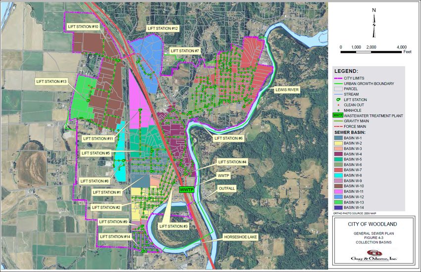
8.1 Sanitary Sewer: Existing Conditions______________________________ 61
8.2 Sanitary Sewer: Projected Needs________________________________65
8.3 Drinking Water: Existing Conditions______________________________65
8.4 Projected Water Service Area, ERUs and Demand___________________69
8.5 Library, Emergency Services, and Schools_________________________69
8.6 Goals and Policies ___________________________________________71
ENERGY AND UTILITIES (EU)________________________________________________75
9.1 Electricity__________________________________________________75
9.2 Natural Gas________________________________________________76
9.3 Telecommunications_________________________________________76
9.4 Implementation of Timely Processes_____________________________76
ENVIRONMENT (E)________________________________________________________81
10.1 Existing Conditions__________________________________________82
10.2 Environmental Regulations____________________________________84
10.3 Goals and Policies___________________________________________85
GROWTH MANAGEMENT (GM)______________________________________________87
11.1 Consistency________________________________________________87
11.2 Plan Amendments __________________________________________87
11.3 Urban Growth Areas_________________________________________88
11.4 Essential Public Facilities______________________________________88
11.5 Goals and Policies___________________________________________89
APPENDICES____________________________________________________________91
Appendix A Public Participation Plan_________________________________91
Appendix B Key Terms and Acronyms________________________________94
City of Woodland, Washington 2016 Comprehensive Plan March 22, 2016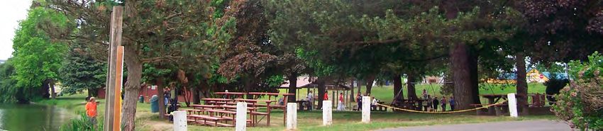
TA B L E S, M A P S, A N D FI GU R E S
TABLES
          Table 3-1. Woodland Planning Assumptions and Targets__________________16
          Table 3-2. Woodland Population – 1910–2015__________________________ 17
          Table 3-3. Woodland Planning Assumptions and Targets__________________18
          Table 5-1. Jobs by NAICS Industry Sector 2013__________________________33
          Table 5-2. Woodland Resident Jobs by NAICS Industry Sector______________35
          Table 5-3. Selection Area Labor Market Size (Primary Jobs)_________________35
          Table 6-1. Intersection Traffic Count Comparisons from 2006–2013___________42
          Table 6-2. Woodland Transportation Capital Improvement Program__________44
          Table 7-1. Woodland Parks and Recreation Six-Year Capital
                     Improvement Program____________________________________58
          Table 8-1. Average Sewer Service Connections by Customer Class for 2013____ 61
          Table 8-2. Water System Connections by Customer Class for 2012___________66
          Table 8-3. Future Water System Needs by Customer Class_________________69
          Table 10-1. Species of Interest_______________________________________83
          Table 10-2. Habitat Areas of Interest__________________________________84

MAPS
          Map 3-1. Woodland Comprehensive Plan Map__________________________ 19
          Map 3-2. Woodland Zoning Map____________________________________20
          Map 5-1. 2013 Woodland Employment Locations________________________32
          Map 5-2. Workforce Residence 2013__________________________________32
          Map 5-3. Woodland Resident Job Commute by Places 2013________________34
          Map 5-4. 2012 Industrial and Highway Commercial Lands Inventory_________36
          Map 6-1. Overview of TISP Improvement Recommendations_______________46
          Map 8-1. Woodland Sanitary Sewer System____________________________62
          Map 8-2. Woodland Water Distribution Map____________________________68

FIGURES
          Figure 3-1. Population Growth 1910–2015______________________________ 17
          Figure 5-1. Jobs Counts by Distance/Direction__________________________33
          Figure 5-2. Jobs by Worker Age 2013__________________________________32

                                    City of Woodland, Washington 2016 Comprehensive Plan March 22, 2016
Figure 5-3. Jobs by Worker Educational Attainment 2013__________________32
           Figure 5-4. Jobs by Earnings 2013____________________________________32
           Figure 5-5. Woodland Resident
           Jobs by Earnings 2013_____________________________________________34
           Figure 5-6. Inflow/Outflow Job Counts 2013____________________________37
           Figure 7-1. City-Owned Recreation Facilities____________________________52
           Figure 7-3. Six-Year Parks and Recreation Expenses_______________________57
           Figure 8-2. Sewer Service Connections by Class (2013)____________________ 61

City of Woodland, Washington 2016 Comprehensive Plan March 22, 2016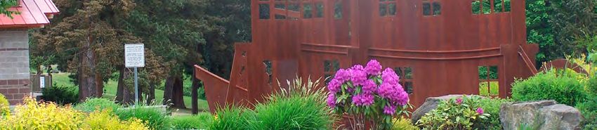
CH A P T ER 1
I N T R O D U C T I O N & CO M MU N I T Y V ISI O N
(V)
1.1.   Goals and Policies

The Woodland Comprehensive Plan includes the essential elements of an inventory of existing
conditions and a forecast of future needs. Each chapter contains one or more goals and multiple
policies designed to implement the goals. The Comprehensive Plan does not prioritize goals and it
does not prioritize policies in support of a goal.

1.2. Woodland Guiding Principals

The Woodland Comprehensive Plan (The Plan) is intended to guide future land use growth
and development over the next twenty years, through 2036. The Plan is based on several
foundational layers:

   • The statutory goals and regulations relating to the Washington Growth Management Act
     (GMA), RCW 36.70A, et seq.;
   • A long-term vision of how our citizens want Woodland to function and to look as it grows
     over the next twenty years;
   • A framework of local goals
     and policies to guide future
     growth and development;
   • A projection of anticipated
     growth during the planning
     period; and
   • An inventory of current public
     services and facilities and a
     projection of what changes
     to such services and facilities
     might be needed to meet
     the future growth of the city.

            City of Woodland, Washington 2016 Comprehensive Plan Section 1 Introduction and Community Vision   V-1
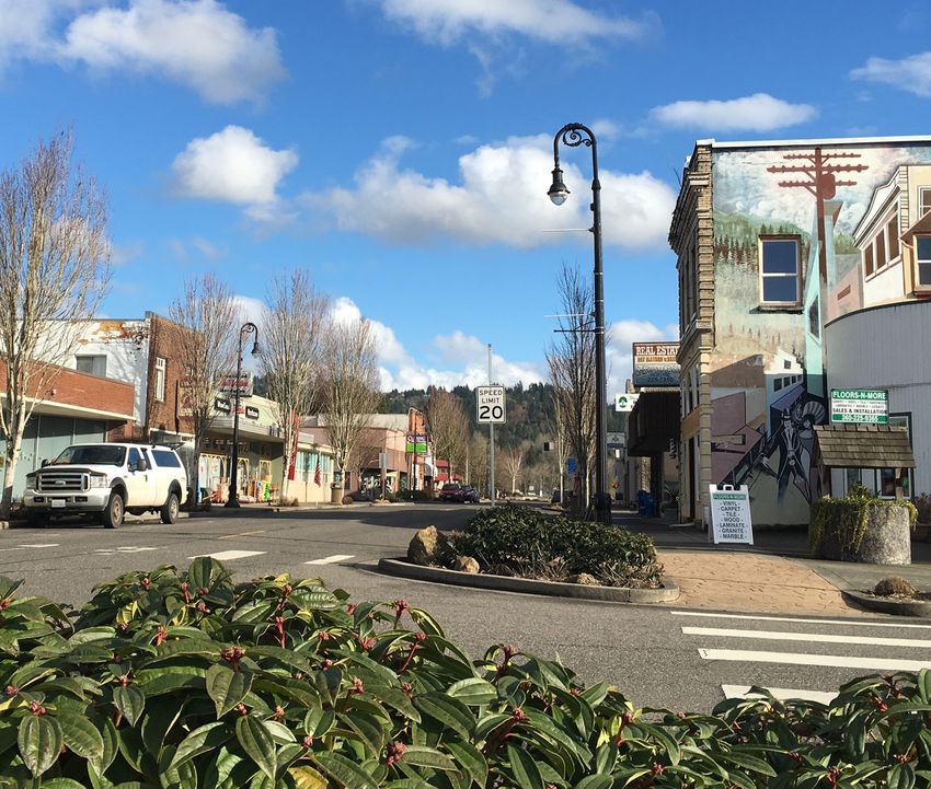
1.3. Woodland Community Vision

      Woodland has a profound commitment to community values, prudent planning, and careful
      execution that preserves resources and maintains the integrity of family neighborhoods. Woodland
      is a community rich in history and proud of its rural heritage. Its vision reflects its history and deep
      commitment to the preservation of those attributes that have made it a successful and welcoming
      place to live and work.

      Woodland will experience continued population growth, greater diversity, higher citizen
      expectations, and increased demand for essential public services. These challenges will be met
      through the innovative use of technology, internal process improvement, creative programs,
      and careful planning. The city will seek new and broader strategic partnerships, invest more in
      economic development, and establish integrated services that ensure safe, balanced, wholesome,
      and harmonious neighborhoods.

      Over the next twenty years Woodland will grow to a population of 9,274 residents. A moderate
      growth rate of 2.3% annually will allow Woodland to remain a community where local and regional
      services are readily accessible.

      Woodland Welcomes

      Woodland is a safe, diverse and welcoming community for current and new residents, businesses,
      and tourists. Its small-town atmosphere and prime location relative to larger metropolitan areas
      and recreation areas make it an attractive destination. While we value and respect our heritage, we
      are committed to adapting to changes in the regional economy, responding to the rapid regional
      growth pressures, and responsibly managing our local natural and historic resources.

      Woodland is Diverse

      Woodland is committed to serve all of its citizens and has facilitated the development of more
      diverse housing opportunities than any nearby city. The city will continue its commitment to
      provide housing opportunities for a wide variety of personal and family needs at various income
      levels. The city will encourage construction of well-planned, integrated, and affordable housing
      while preserving Woodland’s close-knit community and commitment to families and harmonious
      neighborhoods.

      Woodland Grows

      Woodland has a rich agricultural and resource heritage and a burgeoning industrial Port, both of
      which can provide cornerstones for Woodland’s economic future. Because of our location along the
      Interstate 5 corridor and access to rail and river transportation, Woodland is, and will continue to be,
      a commercial service center for southern Cowlitz County and northern Clark County. Woodland will
      develop and maintain a magnetic, highly active and vibrant business community that generates
      consistent, stable and sustainable economic growth and local jobs.

V-2   City of Woodland, Washington 2016 Comprehensive Plan Section 1 Introduction and Community Vision
Woodland Engages
Woodland residents are highly engaged in community events and festivals, and the city aims to
increase engagement in city government. The city believes public participation is essential to good
government and is committed to open and transparent governance and will actively reach out to
its citizens to participate in the public processes.

Woodland Coordinates
The city will dedicate additional effort to developing local and regional partnerships and
strategic alliances that help facilitate coordination and land use consistency among jurisdictions
and agencies.

Woodland Moves
The city will improve and expand its transportation and pedestrian infrastructure. Interstate 5 is a
boon and a barrier to mobility. The Scott Avenue reconnection and sidewalks from downtown to
the Intermediate School will improve mobility. Improved bicycle and pedestrian connections will
facilitate cross-town movement.

Woodland Serves
Woodland’s school system is an asset that will draw families to the community. Residents enjoy the
city’s parks, trails and other recreational opportunities. Residents value and fund police, fire and
emergency response services. Proficient government agencies maintain existing city assets and
coordinate future development.

Woodland Protects and Manages
Woodland values its natural setting, defined by its relationship with places like Horseshoe Lake, the
Lewis River, and Mt. St Helens. Future development will be managed to minimize impacts to the
city’s natural amenities. Parks and trails provide public access to these natural amenities and ensure
they are available to future generation.

Vision Principles

  V 1 Woodland is a small, relatively affordable, full-service community enhanced by proximity
       to regional outdoor and metropolitan resources.
  V 2 The city will maintain small-town community identity based around livable
       neighborhoods and quality schools while accommodating moderate growth.
  V 3 The city will prioritize future expansion of industrial and commercial economic
       opportunities to attract family-wage jobs in the community and commercial services
       for residents.
  V 4 The city will expand infrastructure to serve planned development and will maintain
       adequate levels of service to support the current and future community.

            City of Woodland, Washington 2016 Comprehensive Plan Section 1 Introduction and Community Vision   V-3
V 5 The city will cultivate environmental assets like Horseshoe Lake and the Lewis River for
                both recreational use in the form of parks and trails, and environmental protection.

      1.4      Statutory & Regulatory Framework

      Growth Management Act (GMA)
      The Washington State Growth Management Act (GMA), 36.70A RCW, requires counties which meet
      population and growth criteria to develop, adopt and maintain a comprehensive land use planning
      process consistent with the requirements of the GMA. Among other requirements, comprehensive
      plans must ensure that projected growth in urban areas be accommodated through a range of
      urban densities, that capital facilities keep pace with the growth, and that critical natural resource
      areas are protected and managed.

      Woodland is in an unusual situation in that it is partially in Clark County, which is required to fully
      plan under the Act, and largely in Cowlitz County, which is only required to partially-plan under the
      Act.1 The city crafted this Comprehensive Plan to be consistent with RCW 36.70A, the Clark County
      Countywide Planning Policies, and the Planning Assumptions adopted by the Clark County Board of
      Councilors.

      What’s in the Comprehensive Plan?
      Chapter 1, Introduction and Community Vision, describes the 20-year visions for Woodland.

      Chapter 2, Public Involvement, reaffirms the city’s commitment to open and transparent government
      and its desire to engage and listen to the community.

      Chapter 3, Land Use, describes the planning assumptions underlying the Plan, the housing and
      employment targets, and respect for the city’s past.

      Chapter 4, Housing, describes what will be done to ensure that adequate housing will be available for
      all economic segments of the community.

      Chapter 5, Economic Development, describes what will be done to enhance job growth
      and retention.

      Chapter 6, Transportation, describes the vision for transportation and transportation facilities within
      the city limits and Urban Growth Area (UGA).

      Chapter 7, Parks, Recreation and Open Space, describes community-wide goals and standards for
      parks and recreation facilities.

      Chapter 8, Capital Facilities, describes how roads, water, sewer, parks, and other public facilities and
      services will be provided.

      1
          See Western Washington Growth Management Hearings Board, Case No. 95-2-0068, finding Woodland must fully plan
          under the GMA.

V-4       City of Woodland, Washington 2016 Comprehensive Plan Section 1 Introduction and Community Vision
Chapter 9, Energy and Utilities, reflects the city’s commitment to ensure that public and private
utilities are available to accommodate future growth and ensure its long term sustainability.
Chapter 10, Environment, describes how critical environmental resources will be managed
and protected.
Chapter 11, Growth Management, identifies how the city will comply with the Growth Management
Act over time and work cooperatively with other agencies and districts.
Woodland Supporting Plans and Regulations
The GMA requires jurisdictions planning under the Act to implement the goals and policies of the
local comprehensive plan. Woodland implements The Plan, thereby achieving compliance with the
Act, through implementation of the Woodland Capital Facilities Plan and the Woodland Municipal
Code, particularly Chapters 15 - Environment, 16 - Subdivisions, 17 - Zoning, 18 - Annexation, and 19
- Development Code Administration.
This Comprehensive Plan adopts the following plans by reference:
• Woodland Capital Facilities Plan, including specific elements for:
−− Transportation
−− Sanitary Sewer
−− Potable Water
−− Parks and Recreation
−− Schools
Impact fees and system development charges are adopted by resolution separately.
City of Woodland, Washington 2016 Comprehensive Plan Section 1 Introduction and Community Vision V-5CH A P T ER 2
PU B L I C I N VO LV E M EN T (PI)
Woodland residents are highly engaged in community events and festivals and actively participate
in community-based volunteer activities. When a landslide closed all three northbound lanes
of Interstate 5 north of Woodland in December 2015 government agencies, schools, churches,
businesses, and private citizens, in a genuine outpouring of good will and community spirit, rallied
to aid thousands of stranded motorists with food, shelter, blankets, fuel, parking and more.
Citizen participation in the land use planning process is less active. The city has a very strong desire
to increase engagement in city government. The city believes public participation is essential to
good government and is committed to open and transparent governance and will actively reach
out to its citizens to participate in the public processes.
2.1 Public Participation Plan
The Washington Growth Management Act (GMA) requires cities and counties to conduct public
outreach to ensure “early and
continuous public participation”
when developing and amending
comprehensive plans and
development regulations (RCW
36.70A.140). Local programs must
clearly identify schedules and
procedures for public participation
in the periodic update process (RCW
36.70.A.130(2)(a)). At the beginning
of the Comprehensive Plan update
process the city developed a Public
Participation Plan (PPP) to ensure early
and continuous opportunities for the
public to engage in the plan review
and amendment process.
City of Woodland, Washington 2016 Comprehensive Plan Section 2 Public Involvement PI-11The Goals of the Public Participation Plan were to:
1. Ensure broad participation by identifying key interest groups and soliciting input from
the public.
2. Maintain effective communication and coordination.
3. Focus resources on issues most likely to be of interest to the public.
4. Distribute information and public notices early and efficiently.
The Scope of Work for the PPP was divided into three (3) phases of activity:
Phase I: Review Comprehensive Plan and Development Code for compliance with state law;
identify plan areas to be amended; scope the breadth of the update publicly.
Phase II: Address the issues identified in Phase I.
Phase III: Conduct public hearings and take legislative action.
Elements of the Public Participation Program included:
• Post meeting notices online, in print, and by mail for all meetings and hearings.
• Post planning documents related to the update on the city web pages
• Use interactive and mailed community surveys.
• Maintain an email distribution list and database.
• Conduct an Open House to solicit public feedback.
• Maintain active coordination with Clark County in terms of topics and timelines.
On May 15, 2014 the Planning Commission conducted a public hearing on the PPP and sent the
recommended PPP to the City Council. The City Council reviewed the Planning Commission’s
recommendations and adopted the PPP on June 16, 2014. The city sent a draft of the PPP
to the Washington Department of Commerce 60 days prior to Council final action on the
participation plan.
PI-12 City of Woodland, Washington 2016 Comprehensive Plan Section 2 Public Involvement2.2 Citizen Participation
The city government is committed to implement the Comprehensive Plan in an open and
transparent public process. The city will:
• disseminate information about land use planning proposals and development review through
traditional and electronic media;
• provide ample opportunity for written and oral public comment;
• provide early and effective notice of public meetings, including work sessions, regular
meetings and hearings of the Planning Commission and City Council;
• provide meaningful opportunities for public discussion before the Planning Commission and
City Council, as appropriate; and
• consider and respond to public comments offered during the land use review process and
public hearings; and strive to maintain the city’s web pages and web presence current.
Goal
PI 1 The city government will continue to ensure that citizens have full opportunity to be
heard and to participate in city governmental affairs.
Policies
PI 1 The city shall develop and implement a process to ensure early and continuous public
participation in the comprehensive planning process, including the annual amendment,
emergency amendment, and the periodic update processes.
PI 2 The city will coordinate with agencies providing social services in the city.
PI 3 Consistent with state statute and city policies, Woodland will use local resources to
encourage local involvement in community actions and to enhance community pride.
PI4 Woodland will encourage public and private involvement in community traditions as well
as active encouragement of volunteerism and activism.
PI 5 The city shall develop and implement a process to ensure that regulatory or administrative
actions do not result in an unconstitutional taking of private property.
City of Woodland, Washington 2016 Comprehensive Plan Section 2 Public Involvement PI-13PI-14 City of Woodland, Washington 2016 Comprehensive Plan Section 2 Public Involvement
CH A P T ER 3
L A N D USE (LU)
The Land Use Element considers the general distribution and location of land uses and the
appropriate intensity and density of land uses given current development trends. It describes how
the city will implement the plan elements and goals through land use policies and regulations. It
was developed in accordance with Clark County countywide planning policies and is integrated
with all other planning elements to ensure consistency throughout the comprehensive plan.

The Woodland area is located in the physiographic province known as the Puget Sound Willamette
Valley Trough. The elevation ranges from about 20 feet near the Columbia River to over 1,200 feet
in the hills east of town. The Lewis River and its tributaries form the primary drainage system in the
area and flow west to the Columbia River. The city itself is located on the former floodplain of the
Columbia River with much of it protected by an extensive diking system. However, a substantial
portion of the east side of the city remains within the floodplain of the Lewis River.

3.1      Land Use Planning Assumptions

Woodland is an ‘Urban’ area, as defined by the Growth Management Act. Because county and
city plans must be consistent with each other, Woodland’s planning assumptions align with Clark
County’s ‘Urban’ planning assumptions. The city adopts Clark County’s 1.12% growth rate for the
portion of the city within Clark County
and 2.3% for that portion within
Cowlitz County. Because Woodland
does not have planning jurisdiction
over ‘Rural’ lands, it does not adopt
‘Rural’ planning assumptions. Table 3-1
identifies the planning assumptions
underlying the Woodland
Comprehensive Plan.1

1
    Sources: www.factfinder.census.gov; www.
    quickfacts.census.gov; https://fortress.
    wa.gov; www.city-data.com

                                        City of Woodland, Washington 2016 Comprehensive Plan Section 3 Land Use   LU-15
Table 3-1. Woodland Planning Assumptions and Targets
Planning Assumptions and Targets 2016
2015 Population 5,708
20-Year Population Projection 9,274
Planned Population Growth (new) 3,566
Assumed Annual Population Growth Rate 2.3%
Existing Housing Units 1,933
Person per Household (p/hh) 2.77
Undeveloped residential land 174 acres
Projected Low Density new Housing Starts (4 units/acre) 673
Projected High Density Housing Starts (20 units/acre) 619
Projected Total Housing Units in 2036 3,225
Housing Type Ratio 60% low density,
40% high density
2013 jobs estimate 3,300
Undeveloped Commercial zoned land 124 acres
Projected New Commercial Jobs (20/acre) 2,480
Undeveloped Industrial zoned land 548 acres
Projected New Industrial Jobs (4/acre) 2,192
Current Jobs/Household 1.7:1
Projected Jobs/Household 1.4:1
Infrastructure and Critical Area Deductions 28%
The changes in population in Woodland are closely tied to the economy. During the 1970s the
regional economy contracted because of shrinking timber harvests and the population of the city
decreased. In the late 1990s the population rose dramatically through the mid-2000s. The dramatic
rise in population was linked to the housing boom in Clark County and the Pacific Northwest.
During the 2008-2010 ‘Great Recession’ the national and regional economy experienced rapid
compression and Woodland’s population growth relaxed accordingly. It is reasonable to project that
during this 20-year planning horizon, the city may again see a fluctuation in economic vitality and
corresponding population growth.
LU-16 City of Woodland, Washington 2016 Comprehensive Plan Section 3 Land UseTable 3-2. Woodland Population – 1910–2015
Year 1910 1920 1930 1940 1950 1960 1970 1980 1990 2000 2010 2015*
Population 384 521 1094 980 1292 1336 1622 2415 2500 3780 5509 5708
* April 1, 2015 Estimate
Figure 3-1. Population Growth 1910–2015
Population
6000
5000
4000
3000
2000
1000
0
1910 1920 1930 1940 1950 1960 1970 1980 1990 2000 2010 2015*
City of Woodland, Washington 2016 Comprehensive Plan Section 3 Land Use LU-173.2 Land Use Designations
The Comprehensive Plan Land Use Map (Map 3-1) classifies all land in the city of Woodland and
Woodland UGA. The Comprehensive Plan land use designations are implemented through the
Woodland Zoning Map (Map 3-2) and the Woodland Municipal Code. The land use designations are
described in Table 3-3.
Table 3-3. Woodland Planning Assumptions and Targets
Land Use Designation Sub-Designation and Description Implementing Zone
Residential There is one residential Comprehensive Plan Designation
implemented by multiple residential zones.
Low Density Residential. Areas intended primarily for single- LDR -6, LDR-7.2, LDR-
family dwellings. Densities range from 4 to 6 units per acre. 8.5, and LDR-10
High Density Residential. Areas intended primarily MDR and HDR
for multifamily dwellings of three or more units. The
recommended residential density is up to 35 dwelling units
per gross acre.
Commercial There is one Comprehensive Plan Land Use Designation
implemented by multiple zoning districts. Those
districts include:
• Downtown Commercial -West of I-5, oriented towards C-1
smaller retail and office use;
• Highway Commercial -Primarily oriented to automobile C-2
access and convenience
• Neighborhood Commercial Overlay – Primarily oriented C-3
towards outlets providing convenience goods and services to
residential neighborhoods
Mixed Use. Future land uses might create greater opportunity To be determined
for multiple uses allowed in a zone.
Industrial There is one Comprehensive Plan Land Use Designation
implemented by two zoning districts. Those districts include:
Light Industrial – Designates areas primarily for light L-1
manufacturing, distribution, sales and services, research,
and office.
Heavy Industrial – Designates areas suitable for heavy industry I-2
because of good vehicular access, rail access, or proximity to
existing heavy industry.
Public Facilities/Open Space The Public Facilities Plan Designation facilitates the zoning of
lands for floodways, open space, parks, public and quasi-public
institutional uses. The zoning district include:
Floodway - Applied to areas shown on the Federal Emergency FW
Management Agency, National Flood Insurance Program, City
of Woodland Flood Boundary and Floodway Ma, or its successor.
Use is intentionally restricted.
Public/Quasi-public Institutions – Applied to land in public or PQPI
quasi-public ownership or are operated for the public benefit,
such as, parks, schools, libraries, governmental buildings,
major utility stations, and cemeteries.
LU-18 City of Woodland, Washington 2016 Comprehensive Plan Section 3 Land UseMap 3-1. Woodland Comprehensive Plan Map
SKYVIEW
E
T
SE
IDG
R
ME
NR
M
SO
O
MO
EMPRES
IN
SE
S
L
EX
TE
N
SI
O
N
FOREST PARK
IEW
LE
V
ST
S DA
RE
FO
HILL
AM
B AS
SA
TS
DO
R
IGH
EM
HE
DIKE ACCESS
B AS
F
TH
SY
GREEN MTN
AR
MCC
R AC KE
C
Z
STATESMAN N
BO
E
B
R
CIMERRON
E
OL
IVE
K
NSON
D
BUR
D
IS R
PA
BE
LARCH
C
A
L
IF
LEW
MO
ROBI
SALMON
IC
BLACKTAIL
NT
DAHLIA
WHITE TAIL
LOLO TRAIL
SPRUCE
FRANKLIN
INSEL
MERIWETHER
RHODODENDRON
N
RMA
CLATSOP
WO
DEHNING
MAPLE
INT
PINE
U
OD L
THISTLE
SCH
ER
MADRONA
GUN CLUB
WILLOW
N
AN D
ST
AR
INSO
MACKEN
AT
HERIT
CE D
AGE PONDEROSA ZIE
E
VIEW
CLOVER
RO B
S
5
HE R
ARD
EVERGREEN
SYCAMORE
FOXTAIL HEARTWOOD
T
HO W
HAWTHORNE
FIR
BRO
SCO
VALLEY
REDWOOD MEADOWOOD
T
HILLSHIRE
T HIL
O OD TY
IN GW IS
SPR
L
M
PE
A CH ER
RIVER ROCK
IV
TR E SCO IS R
CARA EE LEW
T
TT
OT
PO RT
SC
HOLLYBERRY
ER
E
GU
IS RIV
ILD
MEADOWPARK
ROSEWOOD
LEW
N GO
WS
C OT TT
ERIG
T O
DOWN RIVER
SC
W
CHERRY BLOSSOM
PAC
IFIC
ATL
MITC
N GO
HE LL
A NTIC
COLUMBIA
ERIG
ER
WOODSIDE
GLENWOOD
IS RIV
Comprehensive Plan Map
N PEKIN
BEECHWOOD HANSEN
LEW
WASHINGTON
GORDON
As of Ordinance No. 1355
FRAZIER
MIL
LAR
Effective March 21, 2016
CC
D
B
E
DA L
A
N
FM A
BUC CC
K EYE
SANDALWOOD
Legend
HO F
CAPLES
T RU
TH City Limits
RO
Urban Growth Boundary
PARK
2ND
3RD
BB
INS
LOVES
BOZARTH PARK
Street Centerlines
IG
6TH
ER
GOERIG Railroad
O
DAVIDSON
G
4TH
DUNHAM Land Use Designations
5TH
ISLAND AIRE
Residential
LAKE Commercial
Industrial
LAK
Public Facilities/Open Space
SP
E
SH
EK
IN
OR
E
RASPBERRY
TSUGAWA
MARTY
MABLE
WIND FLOWER
STAR FLOWER
TWIN FLOWER
N
TO
P K ER
OO PIN
NL
ALE
WH
N
WHALE
WALLACE
/
WYMAN
Disclaimer: The City of Woodland, WA, assumes no legal liability
or responsibility for accuracy and completeness of this map. This
AIRPO RT
map is to be used as a reference tool only. It is not a survey and
the property and lines are not to be construed as being accurate.
0 0.125 0.25 0.5 Miles
City of Woodland, Washington 2016 Comprehensive Plan Section 3 Land Use LU-19SOMMERSET
Map 3-2. Woodland Zoning Map
G
RA
N
IT
E
SKYVIEW
E
T
SE
IDG
R
ME
NR
M
SO
O
MO
EMPRES
IN
SE
S
L
EX
TE
N
SI
O
N
FOREST PARK
IEW
LE
V
ST
S DA
RE
FO
HILL
AM
B AS
SA
TS
DO
R
IGH
EM
HE
DIKE ACCESS
B AS
F
TH
SY
GREEN MTN
AR
MCC
R AC KE
C
Z
STATESMAN N
BO
E
B
R
CIMERRON
E
OL
IVE
K
NSON
D
BUR
D
IS R
PA
BE
LARCH
C
A
L
IF
LEW
MO
ROBI
SALMON
IC
BLACKTAIL
NT
DAHLIA
WHITE TAIL
LOLO TRAIL
SPRUCE
FRANKLIN
INSEL
MERIWETHER
RHODODENDRON
N
RMA
CLATSOP DEHNING
WO
MAPLE
INT
PINE
U
OD L
THISTLE
SCH
ER
MADRONA
GUN CLUB
N
WILLOW
ST
AN D
AR
INSO
MACKEN
AT
HERIT
CE D
AGE PONDEROSA ZIE
E
VIEW
CLOVER
RO B
S
5
HE R
ARD
EVERGREEN
SYCAMORE
FOXTAIL HEARTWOOD
T
HO W
HAWTHORNE
FIR
BRO
SCO
VALLEY
REDWOOD MEADOWOOD
T
HILLSHIRE
T HIL
O OD TY
IN GW IS
SPR
L
M
PE
A CH R
RIVER ROCK
IVE
TR E SCO IS R
CARA EE LEW
T
TT
OT
PO RT
SC
HOLLYBERRY
E
ER
GU
ILD
MEADOWPARK
IS RIV
ROSEWOOD
LEW
N GO
WS
C OT TT
ERIG
T O
DOWN RIVER
SC
W
CHERRY BLOSSOM
PAC
IFIC
ATL
MITC
N GO
HE LL
A NTIC
COLUMBIA
ERIG
Zoning Map
WOODSIDE
ER
GLENWOOD
IS RIV
N PEKIN
BEECHWOOD HANSEN
LEW
WASHINGTON
GORDON
Legend
FRAZIER
MIL
CC LAR
D
B
E
DA L
City Limits
A
N
FM A
BUC CC
K EYE Urban Growth Boundary
SANDALWOOD
HO F
CAPLES Street Centerlines
T RU
TH
Railroad
RO
PARK
2ND
3RD
BB
INS
Zoning Designation
LOVES
BOZARTH PARK
IG
ER
6TH
GOERIG Central Business (C-1)
O
DAVIDSON
G
Highway Commercial (C-2)
4TH
DUNHAM
5TH
Neighborhood Commercial (C-3)
ISLAND AIRE
LAKE
Light Industrial (I-1)
Heavy Industrial (I-2)
Low Density Residential (LDR-6)
LAK
SP
E
SH
EK
Low Density Residential (LDR-7.2)
IN
OR
E
Low Density Residential (LDR-8.5)
RASPBERRY
TSUGAWA
Medium Density Residential (MDR)
MARTY
MABLE
WIND FLOWER High Density Residential (HDR)
STAR FLOWER
TWIN FLOWER P/Q-P/I (Public/Quasi-Public Insitutional)
Floodway Use (FW)
N
P K ER
TO Unzoned (UZ)
OO PIN
NL
ALE
WH
N
WHALE
/
WALLACE
Disclaimer: The City of Woodland, WA, assumes no legal liability WYMAN
or responsibility for accuracy and completeness of this map. This
map is to be used as a reference tool only. It is not a survey and
the property and lines are not to be construed as being accurate.
0 0.125 0.25 0.5 Miles
LU-20 City of Woodland, Washington 2016 Comprehensive Plan Section 3 Land Use
AIRPO RT3.3 Goals and Policies
Goal
LU 1 Protect and enhance the character and long-term stability of the city through current
standards for land development and subdivision.
Policies
LU 1.1 Design, size and construct subdivision streets, sidewalks, alleys, water lines, sewer lines,
and other utilities and facilities in accordance with city standards, ordinances, and plans.
LU 1.2 Proponents of development shall pay their fair and proportionate share of the cost of
repair and improvement of affected properties, facilities, or services if the development
will adversely affect or overload adjacent or nearby public properties, facilities, or services..
LU 1.3 Place utilities underground where possible.
LU 1.4 Coordinate with police department, fire department, school district, and other relevant
public agency comments during the development review process.
LU 1.5 Encourage innovative residential land development techniques to provide greater
housing opportunity and variety of living environments.
LU 1.6 Subdivisions should provide public and/or private open space, consistent with city
standards, to fulfill the active and passive recreation needs of new residents.
LU 1.7 Design and site subdivisions to preserve natural features to the extent feasible.
LU 1.8 Require appropriate mitigation for any development proposal that results in a reduction
of the Level of Service (LOS) standard for the public facilities identified in the Capital
Facilities Element.
LU 1.9 The city shall prepare written findings documenting that a proposed subdivisions
provides appropriate provision for: streets or roads, sidewalks, alleys, other public ways,
transit stops, and other features that assure safe walking conditions for students; potable
water supplies [RCW 19.27.097], sanitary wastes, and drainage ways (stormwater retention
and detention); open spaces, parks and recreation, and playgrounds; and schools and
school grounds, consistent with RCW 58.17.110(2)(a).
LU 1.10 Ensure that the character and location of land uses provides the best opportunity for
economic benefit and the enjoyment and the protection of natural and cultural resources
while minimizing the threat to health, safety, and welfare posed by hazards, nuisances,
incompatible land uses, and environmental degradation.
LU 1.11 Eliminate incompatible land uses through active code enforcement or available
regulatory measures.
LU 1.12 Promote physical activity through land use policies and capital facility plans which
consider urban planning approaches that promote physical activity.
City of Woodland, Washington 2016 Comprehensive Plan Section 3 Land Use LU-213.4 Historic Preservation
In 1845 Adolphus Lee Lewes, a retired employee of the Hudson’s Bay and surveyor, took up a land
claim on property south of the present day city of Woodland in the general area of Whalen Road.
Prior to the establishment of Woodland there were several small communities in the area. The
community of Pekin, near present-day Holland Bulb Farm, had its own Post Office and store but was
destroyed in the 1896 flood. Kerns, which was east of Woodland (Schurman’s corner), had a Post
Office and Steamer Landing. Caples Landing was west of Woodland on the Columbia and Martins
Landing was north of Woodland.
A.W. Scott platted Woodland in 1889 but the town did not incorporate until 1906. Steamboats
plied the waters of SW Washington before the development of a reliable road system. The Steamer
“Mascot” had a colorful history herself and is commemorated by a sculpture in Hoffman Plaza.
(Donated by Margaret Colf Hepola.) The Lucia Mason (possibly spelled the Lucea Mason) sailed
from 1883-1991 and was launched in St. Helens in 1883 by the
Farmers Transportation Co. of Pekin, Washington. The steamer
continued on the Lewis River run for about eight years, sinking
one last time above Kerns (Schurmans Corner) when it hit a
snag. In 1913, the road bridge crossed the Lewis River, signaling
the demise of the ferry service across the river and eventually
transforming the north/south road system into Woodland’s
River of Commerce.
Despite the colorful history, only one property within the city
limits is listed on the National Register of Historic Places, the
Hulda Klager Lilac Gardens, 115 S. Pekin Road. (http://focus.nps.
gov/AssetDetail/NRIS/75001847). The gardens are visited by more
than 25,000 people per year. “Hulda Klager Lilac Gardens
water tower” 1
Several Woodland buildings are potentially eligible for listing as
a state or local historic resource, including:
• 608 Davidson, Woodland, law offices, 1889
• 404 Davidson, Woodland, Woodland Grange #178, 1910
• 339 Davidson, Woodland, commercial building, 1900
• 1423 Goerig, Woodland, private residence, 1880
• 1855 Lewis River Road, Woodland, private residence, 1892
• 345 North Pekin Road, private residence, 1852
1
By Ian Poellet - Own work. Licensed under CC BY-SA 3.0 via Wikimedia Commons - https://commons.wikimedia.org/
wiki/File:Hulda_Klager_Lilac_Gardens_water_tower_-_Woodland_Washington.jpg#/media/File:Hulda_Klager_Lilac_
Gardens_water_tower_-_Woodland_Washington.jpg
LU-22 City of Woodland, Washington 2016 Comprehensive Plan Section 3 Land UseHistoric resources are an excellent resource for
teaching students about the significance of prior
persons, places and events. They can be key ingredient
to the local tourist industry. Historic resources can
play an essential role in the revitalization of an older
downtown. More work needs to be done on a local
level to inventory and preserve historic buildings
and places.
3.5 Goals and Policies
Goal
LU 2 Encourage the protection and preservation of
significant historic, archaeological, architectural,
aesthetic, and cultural resources.
Policies
LU 2.1 Encourage the identification and preservation of local historic properties to create public
awareness of the city’s beginnings, aesthetic appreciation of architecture, maintenance of
community identity, and furtherance of tourism and economic activity.
LU 2.2 Encourage owners of qualified properties to preserve, maintain and rehabilitate their
properties and assist them in applying for listing on the State and National Registers of
Historic Places.
LU 2.3 Encourage identification and rehabilitation of historically significant buildings in a manner
that respects their architectural integrity.
LU2.4 Encourage rehabilitation of historic buildings as a feature of a downtown
revitalization program.
LU 2.5 Investigate the potential of establishing a local historic preservation program in
consultation with the Washington State Office of Archaeology and Historic Preservation
and interested citizens.
City of Woodland, Washington 2016 Comprehensive Plan Section 3 Land Use LU-23LU-24 City of Woodland, Washington 2016 Comprehensive Plan Section 3 Land Use
CH A P T ER 4
H O USI N G (H)
Woodland is committed to maintaining and enhancing our existing neighborhoods while
accommodating future growth in new neighborhoods. Land use goals and policies ensure that the
city maintains an adequate supply of residential land. The housing goals and policies emphasize
preserving existing residential neighborhoods, creating infill opportunities and identifying where
and how new low density and medium density housing will develop.

4.1      Demographics1

In 2014 the population of Woodland was roughly divided between 53% female and 47% male. The
median age was 28.8. Only 9.6% of the population was over the age of 65. Racially, 91.4% of the
population identified as White, 17.9% of the population identified as Hispanic, approximately 2.6%
self-identified as Asian, and less than 1% as Black or African American.

The median household income was
$65,065. Poverty was and is an issue in
Woodland. In 2014 17.4% of all families
and 23.4% of all residents lived below
the federal poverty level ($11,670 one
person/household and $23,850 four
persons per household).2 Poverty levels
differed dramatically across the city. East
of I-5, observed poverty levels ranged
from 6.4% furthest east to 12.2% closer
to the freeway. West of I-5 observed
property levels ranged from 5.56% in
the southern part of the city to 15.7%
near the downtown, to 25.5% at the
western end of town.3 Approximately
22% of the employed workforce did not
have health care in 2014.

1
    Data sources consulted include: 2010-2014 American Community Survey 5-Year Estimates; www.data.wa.gov; www.
    census.gov; www.factfinder.census.gov unless otherwise indicated.
2
    https://aspe.hhs.gov/2014-poverty-guidelines
3
    http://www.city-data.com/income/income-Woodland-Washington.html

                                         City of Woodland, Washington 2016 Comprehensive Plan Section 4 Housing   H-25
4.2 Housing Inventory and Analysis4
2014 demographic trends provide a snapshot of the current growth patterns and provide evidence
of future activity.
• In 2014, there were 1,933 dwelling units in Woodland, an increase of 554 units above the 2000
housing stock.
• In 2014 approximately 67.9% of the housing units in Woodland were single-family detached
units. There were 391 multifamily, attached dwellings between 2 to 19 units, 73 attached units
in complexes of 20 or more units, and 156 mobile homes.
• Woodland’s housing stock is fairly new. Approximately 70% of all units were built after 1990
and only 5% of the homes were built prior to 1939. All dwellings have indoor plumbing.
• Sixty-five percent (65%) of all units were owner occupied. Rental vacancy rate was 5.6%.
• The median price of an owner-occupied unit was $170,800; the median mortgage was $1,611
per month, and median rent was $911 per month.
• Over 75% of all mortgages were less than 30% of household income while 53% of all renters
paid more than 30% of household income towards monthly rent.
• On average, each unit contained approximately 2.77 persons per household.
The 2015 year-end population was approximately 5,708 and the projected 2036 population is 9,274.
To accommodate the addition population of 3,566 persons the city will need an additional 1,288
dwelling units. Woodland has enough vacant buildable lands to accommodate 1,292 new units. By
2036 Woodland may be a city of approximately 3,225 dwellings.
4.3 Statement of Policies that Encourage Affordable Housing
• Within the city limits Woodland will strive to maintain a housing stock of 60% detached low
density housing and 40% medium to high density units.
• The city residential and future mixed use zoning districts will establish minimum densities.
• Development regulations should ‘bevel’ perimeter lot sizes to help blend the transition
between low density and medium density zoning districts.
• Consistent with state law, ‘stick-built’ and manufactured housing are allowed in all residential
districts.
4.4 Growth Management Act
The GMA requires that a housing element be included in the comprehensive plan. Advanced
planning for housing ensures that adequate and affordable housing is available to the community,
4
Source: U.S. Census Bureau, 2010-2014 American Community Survey 5-Year Estimates; www.data.wa.gov; www.
census.gov;
www.factfinder.census.gov
H-26 City of Woodland, Washington 2016 Comprehensive Plan Section 4 Housingand helps to plan for needed infrastructure improvements such as parks, schools, roads, water
systems, etc. The GMA established the following housing goal:
• Encourage the availability of affordable housing to all economic segments of the population
of this state, promote a variety of residential densities and housing types, and encourage
preservation of existing housing.
The Procedural Criteria for Adopting Comprehensive Plans and Development Regulations for the
Act further specifies that the Housing Element of the 20-Year Plan (WAC 365-195-310) shall, at a
minimum, contain:
• An inventory and analysis of existing and projected housing needs;
• A statement of goals, policies, and objectives for the preservation, improvement and
development of housing;
• An identification of sufficient land for housing, including government-assisted housing,
housing for low-income families, manufactured housing, medium density housing and group
homes and foster care facilities;
• Adequate provisions for existing and projected needs of all economic segments of
the community.
The Act further requires inter-jurisdictional coordination and development of county-wide policies
considering affordable housing and its distribution regionally.
A 1993 legislative amendment requires that all cities and public agencies develop an inventory of
public properties no longer needed for use and which may be available for affordable housing. The
inventory identifies individual property locations, size, and current zoning category. Public agencies
include all school districts and state departments of natural resources, transportation, social and
health services, correction, and general administration. The inventory is provided by the city to the
Washington State Office of Community Trade and Economic Development and is to be updated
annually by November 1.
The city is required by the State Housing Act of 1993 to include provisions for accessory housing.
Such provisions are subject to regulations, conditions, and limitations as determined by City Council
(RCW A.63.230).
4.5 Goals and Policies
Goals
H1 Strive to ensure fair and equal access to housing for all people throughout the city
regardless of race, color, national or ethnic origin, religion, creed, age, sex, marital status, or
disability.
H2 Achieve a well-balanced and well-organized combination of open space, commercial,
industrial, recreation, and public uses served by a convenient and efficient transportation
network while protecting the fabric and character of residential neighborhoods.
City of Woodland, Washington 2016 Comprehensive Plan Section 4 Housing H-27Neighborhood Conservation
Goal
H3 Promote desirable neighborhoods that support property values by fostering the
maintenance and improvement of the physical condition of the existing housing stock
and neighborhoods in the city.
Policies
H 3.1 Foster the organization of neighborhood-based groups that encourage housing
maintenance and improvement and assist homeowners in improving neighborhood
quality of life.
H 3.2 Initiate coordination with neighborhood-based groups or other volunteer organizations to
promote rehabilitation and community revitalization efforts.
H 3.3 Advance neighborhood revitalization through public facility improvements servicing the
area (storm drainage, street paving, and recreation). The city should continue to evaluate
public facilities and services in redeveloping areas.
H 3.4 Promote the maintenance, rehabilitation and reuse of existing residences and
neighborhoods as a priority, and use redevelopment only selectively to upgrade badly
deteriorated areas.
H 3.5 Continue to implement the code enforcement program to ensure basic maintenance of
residential properties.
H 3.6 Consider incentives to motivate owners to repair and improve maintenance of their
structures, such as a potential housing rehabilitation program.
Inclusive Housing
Goal
H4 Provide for a variety of housing types and densities, and a range of affordable housing.
Policies
H 4.1 Encourage adequate provision of low and moderate-income housing opportunities to
meet inventory goals and the distribution of such housing throughout the city.
H 4.2 Act positively on programs and proposals that would increase the availability of low cost
housing and assistance to lower income households, including elderly.
H 4.3 Actively participate in regional housing planning and coordination programs and work
closely with local, regional, state and federal housing providers to see that housing needs
of lower income persons are met.
H 4.4 Work with local, regional, state and federal housing providers to educate citizens on
existing housing programs and other opportunities for housing assistance.
H-28 City of Woodland, Washington 2016 Comprehensive Plan Section 4 HousingH 4.5 Carefully examine the needs of the current and projected residents, in order to direct
new housing development, rehabilitated housing, and assisted housing developments to
where it is most needed.
H 4.6 Work to increase the opportunity for all residents to purchase or rent affordable safe and
sanitary housing.
H 4.7 Address the needs of the elderly and prepare for an aging population. Strategies the city
may pursue include:
• Review the availability of land zoned for high-density housing;
• Encourage the construction of multi-family structures with smaller living units (with one
or two bedrooms) and more compact housing types (cluster, townhouse, apartment, or
condominiums);
• Consider the proximity to shopping, medical facilities, libraries, public transportation
routes, retail and service centers, and parks.
Planning and Design for Housing
Goal
H5 Strive to create neighborhoods which enhance residential quality of life by providing
adequate buffers from noise, odors, and other environmental stresses.
Policies
H 5.1 Encourage a development pattern that provides a range of densities and living
environments.
H 5.2 Encourage Planned Unit Residential Developments as an alternative form of residential
development to promote flexibility and creativity in the layout and design of new
residential development large enough to effectively incorporate natural features and
economical provision of services.
H 5.3 Ensure subdivisions develop with adequate transportation access both within the
development and to surrounding land uses. Require public streets unless the developer
proves an alternative private access is superior to the public street standard.
H 5.4 Require adequate off-street parking within multi-family developments to ensure
residential on-street parking is not needed.
H 5.5 Strive to achieve average densities for new development to promote efficiency of land
use and variety of lot sizes for residents. Single-family dwellings shall provide a minimum
density of four units per acre and multifamily dwellings an average density of 20
units per acre.
H 5.6 Regulate manufactured housing similar to ‘stick built’ housing as required by state law.
City of Woodland, Washington 2016 Comprehensive Plan Section 4 Housing H-29Location
Goal
H6 Locate housing in areas with compatible surrounding uses and where residents are able
to access needed amenities.
Policies
H 6.1 Allow retirement housing to locate near medical, transportation and shopping facilities.
H 6.2 Site high density residential development in areas that are:
1. located near commercial areas, downtown, schools, employment centers, and parks
and recreational facilities;
2. near sewer, water, storm drainage facilities, and streets capable of a high level of service
and where access is safe and convenient; and
3. not constrained by critical areas or natural limitations.
H 6.3 Allow upper story residential uses of downtown buildings.
H 6.4 Encourage appropriately scaled infill development of vacant residentially classified land
that is integrated into the neighborhood.
H 6.5 Allow limited opportunities for moderate density in low-density residential areas such as
individual duplexes and accessory dwelling units through appropriate review processes to
minimize impacts to the neighborhood.
H-30 City of Woodland, Washington 2016 Comprehensive Plan Section 4 HousingCH A P T ER 5
E CO N O M I C D E V ELO PM EN T (E C )
Cowlitz County continues to feel the effects of the ‘Great Recession’. Countywide, Cowlitz County
experienced a loss of nearly 4,200 jobs between 2007 and 2012. Regionally the unemployment
rate has been shrinking as the economy rebounds but Cowlitz County unemployment rate in May
2015 was at 7.6%, a percentage point higher than Clark County and 2.3% higher than the national
average at that time. Manufacturing remains the strongest employment sector in the County and
has showed stronger gains than the housing industry in the county. In the short-term Cowlitz
County should experience a 1.5% employment growth rate.1
5.1 Workforce Data2
Jobs in Woodland
In 2013 approximately 3,070 people held a primary job3 in Woodland.4 The Industrial zoning
districts, as expected, produced the heaviest concentration of jobs. See Map 5-1 2013 Employment
Location. (Darker colors indicate areas of more intense job concentration.)
Woodland has become an employment attractor. Figure 5-1 Jobs Counts by Distance/Direction
shows that most of the 2013 in-bound
work force had a 10 to 24 mile, one way
commute. Longview and the Vancouver
area residents represented 45.6% of
the in-bound work force. See Map 5-2
Workforce Residence 2013. Almost 30% of
the 2013 workforce traveled ten miles or
less each way. Fourteen percent (14%) of
the workers commuted 50 miles or more
to work in Woodland.
Approximately 75% of the jobs in
Woodland were held by workers aged
1
Washington State Employment
Security Department
2
2010-2014 American Community Survey 5-Year Estimates; www.data.wa.gov; www.census.gov; www.factfinder.
census.gov.
3
A ‘primary’ job is one worker holding one job.
4
http://onthemap.ces.census.gov/
City of Woodland, Washington 2016 Comprehensive Plan Section 5 Economic Development EC-31You can also read