Broderick Park and Unity Island Waste Water Treatment Plant - P2# 328958
←
→
Page content transcription
If your browser does not render page correctly, please read the page content below
House

                  Broderick Park and Unity Island
                  Waste Water Treatment Plant
                           P2# 328958

        Section 103 Hurricane and Storm Damage Reduction Project

                City of Buffalo, Erie County, New York

          INTEGRATED DETAILED PROJECT REPORT &
               ENVIRONMENTAL ASSESSMENT

                                   January 2020
                                    Prepared by:
              United States Army Corps of Engineers - Buffalo District
                                 1776 Niagara Street
                           Buffalo, New York 14207-3199

                                         i
TABLE OF CONTENTS
1   INTRODUCTION .............................................................................................................................................. 3
         STUDY PURPOSE AND SCOPE ............................................................................................................................... 3
         LOCATION ........................................................................................................................................................ 3
    1.2.1 Broderick Park .......................................................................................................................................... 4
    1.2.2 Waste Water Treatment Plant................................................................................................................. 4
         STUDY AUTHORITY ............................................................................................................................................ 6
         FEDERAL INTEREST............................................................................................................................................. 6
         NON-FEDERAL SPONSOR .................................................................................................................................... 7
         RELEVANT PRIOR STUDIES AND REPORTS ............................................................................................................... 7
2   EXISTING CONDITIONS ................................................................................................................................ 8
         SOCIO-ECONOMIC ENVIRONMENT ........................................................................................................................ 8
    2.1.1 Demographics .......................................................................................................................................... 8
    2.1.2 Water and Associated Land Use and Development ................................................................................. 8
    2.1.3 Public Facilities and Services .................................................................................................................... 8
    2.1.4 Recreation ................................................................................................................................................ 9
    2.1.5 Noise and Aesthetics ................................................................................................................................ 9
    2.1.6 Cultural Resources ................................................................................................................................... 9
    2.1.7 Socio-economic and Environmental Justice ............................................................................................. 9
    2.1.8 Hazardous, Toxic and Radioactive Waste .............................................................................................. 10
         PHYSICAL AND NATURAL ENVIRONMENT.............................................................................................................. 11
    2.2.1 Climate ................................................................................................................................................... 11
    2.2.2 Topography and Soils ............................................................................................................................. 12
    2.2.3 Water Quality ........................................................................................................................................ 12
    2.2.4 Air Quality .............................................................................................................................................. 13
    2.2.5 Lake Levels and Water Depths ............................................................................................................... 14
    2.2.6 Vegetation and Aquatic Resources ........................................................................................................ 15
    2.2.7 Wildlife Habitats .................................................................................................................................... 15
    2.2.8 Endangered and Threatened Species ..................................................................................................... 15
    2.2.9 Shoreline Structures ............................................................................................................................... 16
        2.2.9.1         Reach 1 ......................................................................................................................................................... 16
        2.2.9.2         Reach 2 ......................................................................................................................................................... 23
    2.2.10          Wave Analysis.................................................................................................................................... 26
        2.2.10.1        Wave Overtopping Rates .............................................................................................................................. 26
        2.2.10.2        Wave Overtopping Rates – Reach 1 .............................................................................................................. 29
        2.2.10.3        Wave Runup and Overtopping Rates – Reach 2............................................................................................ 30

3   PLAN FORMULATION .................................................................................................................................. 31
         PROBLEMS AND OPPORTUNITIES ........................................................................................................................ 31
    3.1.1  Problems ................................................................................................................................................ 31
    3.1.2  Opportunities ......................................................................................................................................... 31
         OBJECTIVES AND CONSTRAINTS .......................................................................................................................... 32
    3.2.1 Planning Objectives................................................................................................................................ 32
    3.2.2 Planning Constraints .............................................................................................................................. 32

                                                                                        ii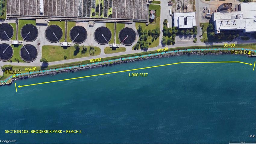
MOST PROBABLE FUTURE WITHOUT PROJECT CONDITIONS .................................................................................... 33
         MEASURES TO ACHIEVE PLANNING OBJECTIVES .................................................................................................... 35
    3.4.1 Preliminary Measures ............................................................................................................................ 36
    3.4.2 Measure 2 – Grout Timber Crib (Reach 1).............................................................................................. 41
    3.4.3 Measure 3 – Install Steel Plate (Reach 1) ............................................................................................... 43
    3.4.4 Measure 4 – New Drainage and Replacement of Fill Material (Reach 1) .............................................. 44
    3.4.5 Measure 5 – Concrete Surface Repair (Reach 1) .................................................................................... 45
    3.4.6 Measure 6 – New Stone Revetment (1V:3H) (Reach 2).......................................................................... 46
    3.4.7 Measure 7 – New Stone Revetment (1V:2H) (Reach 2).......................................................................... 47
    3.4.8 Measure 8 – New Stone Revetment (1V:3H and 1V:2H) ........................................................................ 48
         FORMULATION OF ALTERNATIVES ....................................................................................................................... 49
    3.5.1 Alternative 1 – No Action ....................................................................................................................... 50
    3.5.2 Alternative 5 – Grout Timber Crib, Steel Plate, Concrete Surface Repair, New Stone Revetment 1V:3H
           50
    3.5.3 Alternative 6 – Grout Timber Crib, Steel Plate, Concrete Surface Repair, New Stone Revetment 1V:2H
           51
    3.5.4 Alternative 7 – Grout Timber Crib, Steel Plate, Concrete Surface Repair, New Stone Revetment 1V:3H
    & 1V:2H ............................................................................................................................................................... 51
    3.5.5 Alternative 8 - Grout Timber Crib, Steel Plate, Concrete Surface Repair, New Drainage, New Stone
    Revetment 1V:3H ................................................................................................................................................ 52
    3.5.6 Alternative 9 - Grout Timber Crib, Steel Plate, Concrete Surface Repair, New Drainage, New Stone
    Revetment 1V:2H ................................................................................................................................................ 52
    3.5.7 Alternative 10 - Grout Timber Crib, Steel Plate, Concrete Surface Repair, New Drainage, New Stone
    Revetment 1V:3H & 1V:2H .................................................................................................................................. 52
         COMPARISON OF ALTERNATIVES ........................................................................................................................ 52
    3.6.1 Costs of Alternatives .............................................................................................................................. 52
    3.6.2 Economic Analysis .................................................................................................................................. 54
        3.6.2.1         Shoreline Related Maintenance / Rehabilitation Costs Avoided .................................................................. 55
        3.6.2.2         Average Annual Costs Avoided Benefits ....................................................................................................... 56
        3.6.2.3         Benefits to Cost Analysis ............................................................................................................................... 57
         ACCEPTABILITY, COMPLETENESS, EFFECTIVENESS, AND EFFICIENCY ........................................................................... 57
    3.7.1 Acceptability .......................................................................................................................................... 57
    3.7.2 Completeness ......................................................................................................................................... 58
    3.7.3 Effectiveness .......................................................................................................................................... 58
    3.7.4 Efficiency ................................................................................................................................................ 58
         NATIONAL ECONOMIC DEVELOPMENT PLAN ......................................................................................................... 58
         RISK AND UNCERTAINTY ................................................................................................................................... 59
         RECOMMENDED PLAN...................................................................................................................................... 61
    3.10.1     Estimated Project Costs ..................................................................................................................... 61
         CLIMATE PREPAREDNESS AND RESILIENCE ............................................................................................................ 63
4   ENVIRONMENTAL EFFECTS OF THE RECOMMENDED PLAN ........................................................ 65
         SOCIO-ECONOMIC ENVIRONMENT ...................................................................................................................... 66
    4.1.1 Recreational, Scenic, and Aesthetic Resources ...................................................................................... 66
    4.1.2 Cultural Resources ................................................................................................................................. 66
    4.1.3 Noise ...................................................................................................................................................... 66

                                                                                     iii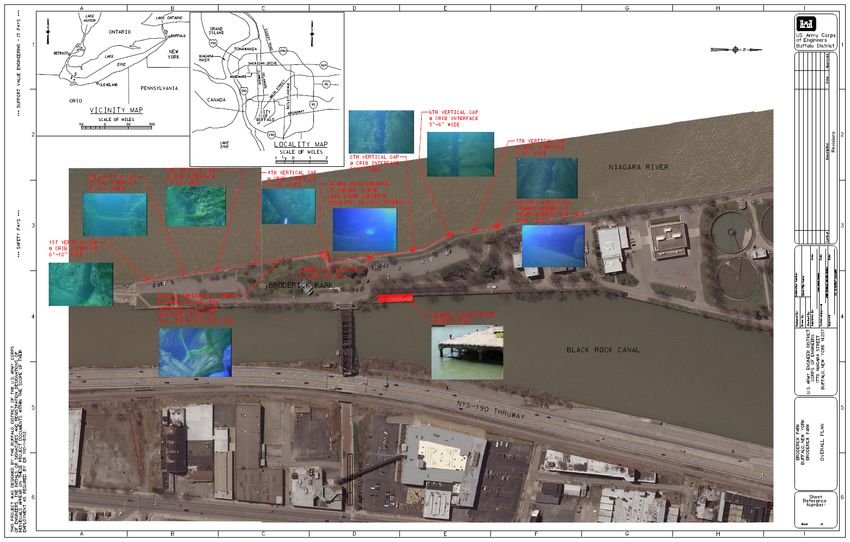
4.1.4  Hazardous, Toxic and Radioactive Waste .............................................................................................. 67
       4.1.5  Socioeconomic and Environmental Justice ............................................................................................ 68
            PHYSICAL AND NATURAL ENVIRONMENT.............................................................................................................. 68
       4.2.1 Topography and Soils ............................................................................................................................. 68
       4.2.2 Water Quality ........................................................................................................................................ 68
       4.2.3 Vegetation and Aquatic Resources ........................................................................................................ 69
       4.2.4 Wildlife Habitats .................................................................................................................................... 69
       4.2.5 Endangered and Threatened Species ..................................................................................................... 70
       4.2.6 Air Quality .............................................................................................................................................. 70
            CUMULATIVE EFFECTS ...................................................................................................................................... 70
5      IMPLEMENTATION REQUIREMENTS ..................................................................................................... 71
            INSTITUTIONAL REQUIREMENTS ......................................................................................................................... 71
            PROJECT PARTNERSHIP AGREEMENT (PPA).......................................................................................................... 72
            COST APPORTIONMENT .................................................................................................................................... 74
            REAL ESTATE ............................................................................................................................................... 76
       5.4.1 Project Land Ownership ......................................................................................................................... 76
       5.4.2 Relocations............................................................................................................................................. 76
       5.4.3 Values .................................................................................................................................................... 76
            MONITORING AND MAINTENANCE CONSIDERATIONS ............................................................................................. 76
6      COMPLIANCE WITH ENVIRONMENTAL PROTECTION REQUIREMENTS .................................. 77
            ARCHAEOLOGICAL AND HISTORICAL PRESERVATION ACT OF 1979 (16 USC 470 ET SEQ.); NATIONAL HISTORIC
    PRESERVATION ACT OF 1966 (16 USC 470 ET SEQ.); EXECUTIVE ORDER 11593 (PROTECTION AND ENHANCEMENT OF THE CULTURAL
    ENVIRONMENT), MAY 13, 1979 .................................................................................................................................... 77
            CLEAN AIR ACT, AS AMENDED (42 USC 7401 – 7671G) ..................................................................................... 77
            CLEAN WATER ACT, AS AMENDED (33 USC 1251 ET SEQ.) ................................................................................. 77
            COASTAL ZONE MANAGEMENT ACT OF 1972, AS AMENDED (16 USC 1451 – 1464) ................................................ 77
            ENDANGERED SPECIES ACT, AS AMENDED (16 USC 1531 ET SEQ.) .......................................................................... 78
            NATIONAL ENVIRONMENTAL POLICY ACT (42 USC 4321 – 4347) .......................................................................... 78
            RIVER AND HARBOR ACT OF 1970 (P.L. 91-611) ................................................................................................ 78
            FISH AND WILDLIFE COORDINATION ACT (16 USC 661 ET SEQ.) ........................................................................... 78
            WILD AND SCENIC RIVERS ACT (16 USC 1271, ET SEQ.) ........................................................................................ 78
            FEDERAL WATER PROJECT RECREATION ACT; AND LAND AND WATER CONSERVATION ACT (16 USC 460L-12 – 4601-22,
    662) 79
            WATERSHED PROTECTION AND FLOOD PREVENTION ACT ........................................................................................ 79
            EXECUTIVE ORDER 11990, PROTECTION OF WETLANDS, MAY 24, 1977 .................................................................. 79
            EXECUTIVE ORDER 11988, FLOOD PLAIN MANAGEMENT, MAY 24, 1977 ................................................................ 79
            EXECUTIVE ORDER 12898, FEDERAL ACTIONS TO ADDRESS ENVIRONMENTAL JUSTICE IN MINORITY POPULATIONS AND LOW-
    INCOME POPULATIONS, FEBRUARY 11, 1994; EXECUTIVE ORDER 12948, AMENDMENT TO EXECUTIVE ORDER 12898, JANUARY, 30,
    1995 79
            ANALYSIS OF IMPACTS ON PRIME AND UNIQUE FARMLANDS, CEQ MEMORANDUM, 30 AUGUST 1976 ..........................79
            OTHER PUBLIC LAWS AND EXECUTIVE ORDERS ...................................................................................................... 79
7      PUBIC INVOLVEMENT / AGENCIES......................................................................................................... 81
8      RECOMMENDATION .................................................................................................................................... 83

                                                                                   iv
9      REFERENCES.................................................................................................................................................. 84
10     ACRONYMS ..................................................................................................................................................... 86

                                                              LIST OF FIGURES
Figure 1-1: Study Location Map .................................................................................................................. 5
Figure 1-2: Plan view of the project area and locations of repair Reaches 1 & 2 ......................................... 6
Figure 2-1: Map showing Lake Erie’s 254 mile fetch distance and a diagram illustrating wind driven
seiches on Lake Erie ................................................................................................................................... 14
Figure 2-2: Map showing the original location of the Ferry before expansion of Unity (Squaw) Island
(Sass, 1983). ................................................................................................................................................ 17
Figure 2-3: Typical Stone Filled, Timber Crib Structure ............................................................................ 18
Figure 2-4: Dive Inspection Results. Embedded photographs show vertical gaps between timber cribs,
missing horizontal timber members, and severe deterioration at the corner (red hatched area) ................. 21
Figure 2-5: Exploration Pit Locations (USACE, 2013) .............................................................................. 22
Figure 2-6: Deteriorated Concrete Monolith with Loss of Crest Height (USACE Photo) ......................... 22
Figure 2-7: Extent of Reach 2 ..................................................................................................................... 23
Figure 2-8: Reach 2 – Typical Existing Cross Section Drawing ................................................................ 23
Figure 2-9: Bike curb under construction and existing laid-up stone revetment (June, 29, 2017) (USACE
Photo) .......................................................................................................................................................... 24
Figure 2-10: Reconstruction of 350 feet of revetment and southern outfall (June 29, 2017) (USACE
Photo) .......................................................................................................................................................... 25
Figure 2-11: Existing laid-up stone and bike path curb (May 11, 2018) (USACE Photo) ......................... 25
Figure 2-12: Reconstructed southern 350 feet of Reach 2 (May 11, 2018) (USACE Photo) ..................... 26
Figure 2-13: Study Locations and Areas Affecting Wave Propagation ...................................................... 27
Figure 3-1: Measure 2 - Grout top of timber crib ....................................................................................... 42
Figure 3-2: Measure 3 - Grout vertical gaps between timber cribs ............................................................. 42
Figure 3-3: Example of a portable cofferdam ............................................................................................. 43
Figure 3-4: Install Steel Plate ...................................................................................................................... 44
Figure 3-5: Measure 4 - New drainage and replacement of fill material .................................................... 45
Figure 3-6: Identified areas that need concrete surface repair .................................................................... 46
Figure 3-7: Measure 5 - Concrete surface repair (Reach 1) ........................................................................ 46
Figure 3-8: Measure 6 - New stone revetment (1V:3H) (Reach 2)............................................................. 47
Figure 3-9: Measure 7 - New Stone Revetment (1V:2H) ........................................................................... 48
Figure 3-10: Measure 8 - New Stone Revetment (1V:3H and 1V:2H) (Reach 2) ...................................... 48

                                                               LIST OF TABLES
Table 2-1: Air Quality Statistics Report Buffalo-Niagara Falls, NY, CBSA ............................................. 13
Table 2-2: Lake Level-Frequency Information & Design Water Depths ................................................... 28
Table 2-3: Stage (FT - IGLD 85) along Broderick Park Timber crib wall (HEC-RAS results) ................. 28
Table 2-4: Max velocity (FT/s) at Broderick Park Timber crib wall (HEC-RAS results) .......................... 28

                                                                                  v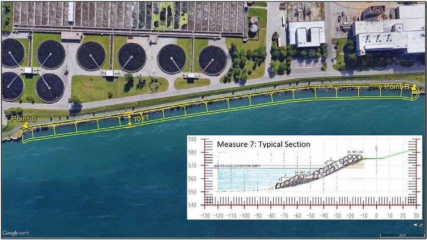
Table 2-5: Summary of Design Wave Heights ........................................................................................... 29
Table 2-6: Summary Wave Crest Forces for Submerged Timber crib wall................................................ 30
Table 2-7: Crest Freeboard Distances at Point A ........................................................................................ 30
Table 2-8: Wave Overtopping Rate at Point A ........................................................................................... 30
Table 3-1: Concepts and evaluations generated from the Value Engineering Study. ................................. 37
Table 3-2: List of management measures and preliminary screening ......................................................... 39
Table 3-3: Preliminary project alternatives ................................................................................................. 49
Table 3-4: Final array of alternatives .......................................................................................................... 50
Table 3-5: Measures Rough Order of Magnitude Costs, First Costs of Construction, Contingencies and
Average Annual Costs ................................................................................................................................ 53
Table 3-6: Project alternatives and associated average annual costs .......................................................... 53
Table 3-7: ROM Average Annual Benefits, Average Annual Costs, Benefit to Cost Ratio and Net
Benefits ....................................................................................................................................................... 57
Table 3-8: Risk Register for Section 103 Project at Unity Island/Broderick Park ..................................... 60
Table 3-9: Recommended Plan Cost Estimate and Economic Summary ................................................... 63
Table 5-1: Implementation Schedule .......................................................................................................... 72
Table 5-2: Estimated Project Costs and Apportionment ............................................................................. 75

                                                        LIST OF APPENDICES
APPENDIX A               PHASE I ENVIRONMENTAL SITE ASSESSMENT
APPENDIX B               DIVE INSPECTION REPORT
APPENDIX C               HYDRAULICS, HYDROLOGY AND COASTAL ENGINEERING
APPENDIX D               VALUE ENGINEERING STUDY
APPENDIX E               CIVIL STRUCTURAL DESIGN
APPENDIX F               ECONOMIC
APPENDIX G               COST ENGINEERING
APPENDIX H               REAL ESTATE PLAN
APPENDIX I               NATIONAL ENVIRONMENTAL POLICY ACT (NEPA) COMPLIANCE

                                                                                vi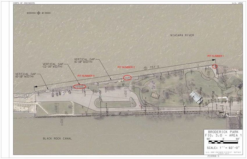
DRAFT FINDING OF NO SIGNIFICANT IMPACT (FONSI)
                       CONTINUING AUTHORITIES PROGRAM
                    BRODERICK PARK STORM DAMAGE REDUCTION

                                     BUFFALO HARBOR
                                  ERIE COUNTY, NEW YORK

The U.S. Army Corps of Engineers (USACE), Buffalo District has assessed the environmental
impacts of the Broderick Park Section 103 project in accordance with the National
Environmental Policy Act (NEPA) of 1969 and has determined a Finding of No Significant
Impact (FONSI) is appropriate. The attached Environmental Assessment (EA) presents the
results of the environmental analysis. The purpose of this project is to provide storm damage
reduction measures along the shoreline of Unity Island, in the city of Buffalo, Erie County, New
York.

Seven alternative plans, including the No Action Alternative, were carried forward for detailed
evaluation. These seven alternatives included various combinations of measures to grout the
timber crib structures, install steel plates, install new drainage, and replacement of fill material,
repair concrete surface, and new stone revetments at varying slopes. Alternative 6 was identified
as the National Economic Development (NED) Plan because it is the plan with the highest
benefit to cost ratio that most completely meets the objectives of reducing storm damages along
Unity Island and protect the City of Buffalo’s only waste water treatment plant (WWTP). This
alternative involves pumping grout into the top two feet of the timber crib along 700 feet of
Reach 1, and into the full depth of the crib at 12 additional locations. This would help prevent
further loss of fill material from the timber cribs and provide support to the concrete cap where
the timbers are missing. Additionally, by installing steel plate along the entire length of the
timber crib near to the water line, the existing structures will be protected from water and ice
impacts for the project life. Further, Alternative 6 involves resurfacing the concrete monolith
along 344 linear feet of Reach 1. Alternative 6 also proposes a new stone revetment be
constructed at a 1V:2H slope for the entirety of Reach 2. Combined, these four measures offer
long term repairs that address the overtopping, stability, and structural issues of the seawall and
rubblemound in front of the WWTP at Unity Island.

A scoping document was distributed to the public, local, state, and federal agencies and Indian
tribes on January 25, 2018. No comments were received regarding this document. The U.S.
Fish and Wildlife Service submitted a draft Fish & Wildlife Coordination Act Report in
September 2018 indicating that there were no federally listed threatened or endangered species
that would be affected by the proposed project. Compliance with Section 106 of the historic
preservation act is ongoing however it is not expected to have an adverse impact. Clean Water
Act Section 401 and 404 compliance is necessary for the revetment portion of the project, and
will be obtained prior to construction. Lastly, the project is in compliance with the policies of
the New York State Coastal Zone Management Program. Concurrence with this determination
will be sought during the Construction Phase of the project.

The USACE-Buffalo District has analyzed the proposed project and has concluded that the
construction of the Recommended Alternative would not constitute a major federal action that

                                                  1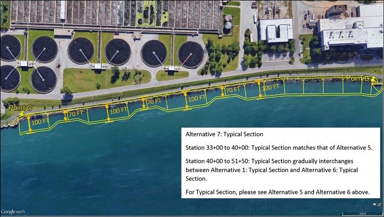
would significantly affect the quality of the human or natural environment. Public coordination
and consultation, to date, has revealed no unresolved areas of environmental controversy and no
substantial adverse comments were received during the 30-day public review scoping period.
Based on these factors, I have determined that an Environmental Impact Statement will not be
required.

Date ______________                                LTC Jason A. Toth
                                                   Lieutenant Colonel, Corps of Engineers
                                                   District Commander

                                               2
1 INTRODUCTION
Study Purpose and Scope
This study evaluates the feasibility of constructing storm damage reduction measures along the
shoreline of Unity Island, in the City of Buffalo, Erie County, New York. During this feasibility
study, alternative plans have been evaluated in conjunction with the non-federal project sponsor
(City of Buffalo) for their effectiveness in reducing storm damages. If this evaluation determines
that there is a feasible alternative, then a recommendation will be made to continue into the
Design and Implementation Phase, to include preparation of plans and specifications and
eventually construction. Once this Detailed Project Report and Environmental Assessment
(DPR/EA) has been approved at the division level, a detailed project cost estimate and
construction schedule will be prepared. This DPR/EA also includes a Finding of No Significant
Impact (FONSI) to summarize the environmental impacts and document compliance with the
National Environmental Policy Act (NEPA).
Location
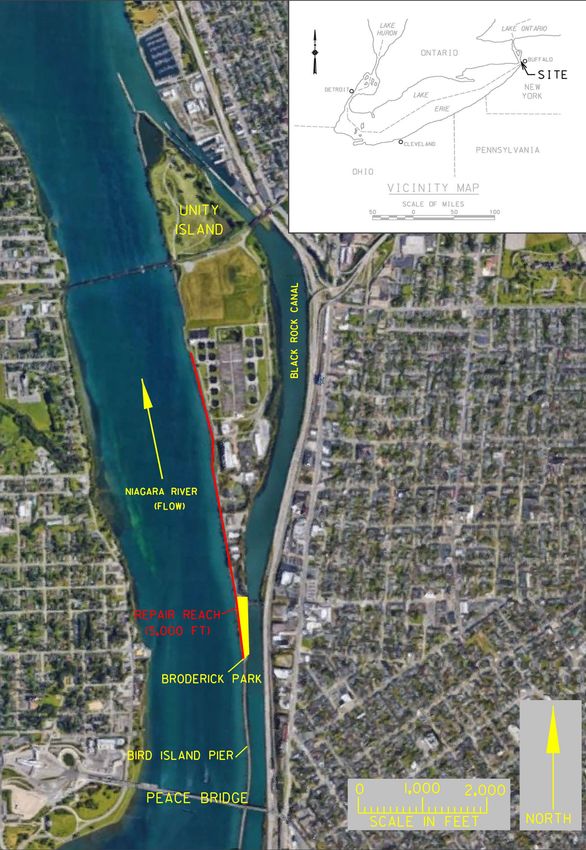
The city of Buffalo’s Waste Water Treatment Plant (WWTP) is located on Unity Island, a
riverine island in the uppermost reach of the upper Niagara River in the City of Buffalo, Erie
County, New York. The Broderick Park and WWTP shoreline is protected by approximately
3,000 feet of stone-filled, concrete capped, timber crib wall. The northern 2,295 feet being
considered for repair is referred to as Reach 1 and the southern 1,760 feet is referred to as Reach
2 (Figure 1-1 and Figure 1-2). Lake Erie storms have deteriorated much of the existing shore
protection along the Niagara River side of Unity Island. Lake Erie is prone to wind-generated
seiche events due to its relative shallowness and elongation on a northeast-southwest axis.
Prevailing southwesterly winds maximize the fetch distance (i.e., 300 miles open water fetch
from Toledo, Ohio to Buffalo Harbor, NY) causing large waves and high water levels to occur
near the project area.
Sections of the existing concrete seawall, stone-filled timber crib foundation, and stone
revetment have deteriorated significantly over the past 50 years resulting in decreased protection
for the WWTP, park, and their associated roadways. The City of Buffalo maintenance and repair
efforts of the Broderick Park shoreline have been more frequent and extensive within the past
five years, suggesting an acceleration of the shoreline’s deterioration. This deterioration is
expected to continue and potentially accelerate exponentially. Based on multiple site visits, a
dive inspection, and engineering judgment, it is estimated that some portion of the wall could fail
within the next 15 to 20 years.
If multiple storm events were to occur in this area, failure of the wall and armored shoreline
could drastically accelerate and occur sooner than the estimated 15 to 20 years. Protection is
required to be completed in the near future to maintain a safe buffer. If the current shoreline
protection were to fail prior to a project being implemented, catastrophic landward retreat may
occur suddenly and unexpectedly. Additionally, given that this area experiences high flow rates
from the Niagara River, shoreline erosion would be compounded and accelerated during a storm
3
event which would initially threaten access to the pedestrian trail adjacent to the WWTP; then
undermining the security fence and plant access road, and ultimately the infrastructure of the
WWTP itself.

1.2.1   Broderick Park

Broderick Park is located on the southern tip of Unity Island between the Niagara River and the
Black Rock Canal and offers recreational facilities for local residents and visitors. The park
overlooks the Canada–U.S. border and is situated within view of the Peace Bridge, which links
the State of New York with the Canadian Province of Ontario at Fort Erie.

The park’s historical importance includes its use as a stop and transfer point for the Underground
Railroad in the first half of the 19th century. A plaque in the park pays tribute to the men and
women who crossed the water of the Niagara River from that point to freedom in Canada.

Broderick Park has seen significant investment from local and state government in recent years,
including a $2.4 million infrastructure improvement project. Improvements have included: a
new shelter, railings, sidewalks, bike path, amphitheater and central outlook concession building
improvements, a new parking area, landscaping, and an Underground Freedom Walk pathway.

1.2.2   Waste Water Treatment Plant

Since 1938, the WWTP located adjacent to Broderick Park on Unity Island has safeguarded
public health and protected the Niagara River and other tributary streams from pollution by
collecting and treating sewage generated by the City of Buffalo. The plant provides wastewater
treatment for all water users located in the City of Buffalo. This includes all 267,000 city
residents, all commercial and industrial users, as well as the city’s downtown core of office
buildings, hotels, and public service buildings (e.g., hospitals, colleges, court system, holding
center, convention center, Erie County Community College, police and fire stations, etc.). The
WWTP also treats wastewater from all or parts of 11 municipalities in Western New York. The
total collection consists of 790 miles of combined sewers (storm/wastewater) and 60 miles of
separate sewer systems.

In the mid-1970s, in direct response to the Clean Water Act, the WWTP was upgraded to meet
new secondary treatment standards added at the plant between 1975 and 1979. With this
upgrade, aeration and secondary clarification equipment were added along with upgrades to the
disinfection system. Currently, the WWTP is the second largest plant in New York State with a
design average flow of 180 million gallons per day. Since the secondary plant was constructed,
the Buffalo Sewer Authority has continued to improve and upgrade other areas of the plant with
over $30 million of capital investment made in the past 10 to 15 years. The plant is part of the
Buffalo Sewer Authority Long Term Control Plan to manage combined sewage and was
approved by the New York State Department of Environmental Conservation (NYSDEC) on
March 18, 2014. The plan calls for $41 million in upgrades to the WWTP.

                                                4
Study Area (red)
Figure 1-1: Study Location Map
5Figure 1-2: Plan view of the project area and locations of repair Reaches 1 & 2
Study Authority
This investigation was conducted under the authority of Section 103, River and Harbor Act of
1962, Public Law 79-727, as amended (33 U.S.C. 426g). This legislation provides the Secretary
of the Army authority to investigate and assist in prevention of shore damages caused
predominantly by wind-generated waves. Federal participation in shore protection projects on
Great Lakes shores is conducted according to Section IV, subsection E22, page E-133 of
Engineer Regulation 1105-2-100: Planning Guidance Notebook 22 April 2000.
The Section 103 authority may be used for protecting multiple public and private properties and
facilities, as well as, single non-federal public properties and facilities against damages caused
by storm driven waves and currents. All projects must be formulated for hurricane and storm
damage reduction, in accordance with current policies and procedures governing projects of the
same type as specifically authorized by Congress.
The federal cost limitation for a CAP Section 103 project was increased under Sec 1167
WRDA/WIIN 2016 from five to ten million dollars (see authorizing language below).
SEC. 1167. HURRICANE AND STORM DAMAGE REDUCTION.
Section 3(c)(2)(B) of the Act of August 13, 1946 (60 Stat. 1056, chapter 960; 33 U.S.C.
426g(c)(2)(B)), is amended by striking ‘‘$5,000,000’’ and inserting ‘‘$10,000,000’’.
Federal Interest
The Determination of Federal Interest (July 2014) concluded that there is a federal interest in
pursuing a project under Section 103 of the 1962 River and Harbor Act, as amended;
Construction General (Continuing Authorities Program). This was accomplished by
demonstrating the opportunity for a project resulting in significant economic benefits with a
6benefit to cost ratio of 1.82 based on avoidance of future seawall/rehabilitation costs, as well as
being consistent with USACE and budgetary policies.
Non-Federal Sponsor
The City of Buffalo was identified as the project sponsor for the feasibility study as indicated by
their Letter of Intent dated June 12, 2014. A Feasibility Cost Share Agreement between the U.S.
Army Corps of Engineers - Buffalo District and the City of Buffalo was entered into on April 4,
2016. The City of Buffalo has indicated that they are committed to maintaining the structural
integrity of the shoreline to protect Broderick Park and the WWTP. Upon completion of the
Feasibility Phase and prior to execution of a Project Partnership Agreement for Design and
Construction, the City of Buffalo will seek to fund their portion of the project through a series of
grants from entities that have provided funding for similar projects in the past. The City will
budget any remaining funds required for this project in their capital improvement plan. The
primary source of these funds will come from the issuance of a bond approved by the City’s
Common Council.
Relevant Prior Studies and Reports
Dive Inspection of Seawall at Broderick Park, prepared by USACE – Buffalo District,
2012. The dive inspection was conducted to perform an underwater inspection of the seawall
surrounding Broderick Park (Niagara River side and Black Rock Channel side) to determine its
current condition. An aquatic habitat assessment was also conducted. The general condition of
the seawall at Broderick Park is fair to poor on the river side with deterioration of the timber
crib, loss of infill and multiple sinkholes behind the wall. The seawall along the canal side is in
good to fair condition with no evident displacement and no sink holes behind the wall.
Broderick Park Repair and Ecological Enhancement, prepared by USACE – Buffalo
District, 2013. The purpose of this report prepared by USACE – Buffalo District was to present
the rehabilitation method for portions of the Broderick Park river side timber crib structure.
Additionally, some options were presented for various potential ecological enhancements. The
structural repair and the ecological enhancements are provided for possible future development,
detailed design, and possible construction by others outside of USACE or by USACE.
Broderick Park (Squaw Island Waste Water Treatment Plant) Federal Interest
Determination, prepared by USACE – Buffalo District, 2014. The economic evaluation
determined that a federal project at Broderick Park (Unity Island) is economically justified. Two
of the plans evaluated had positive benefit to cost ratios. Given that the two plans have positive
benefit to cost ratios, supporting a positive federal interest for this project, movement of this
study into the Feasibility Phase was recommended. The City of Buffalo indicated that they are a
willing local sponsor for the feasibility phase of this study.
72 EXISTING CONDITIONS
This section is intended to describe the existing socio-economic and physical conditions of the
proposed project area along Broderick Park as determined through resource reviews and on-site
field inspections. Where applicable, the likely future condition of this seawall, if no federal
project is constructed, is also discussed.
Lake Erie storms over the years have deteriorated the shoreline along Broderick Park/Unity
Island. This section of shoreline is susceptible to a 330-mile open water fetch between Toledo,
Ohio to Buffalo, New York. Prevailing southwesterly winds maximize the fetch distance
causing large waves and high water levels that impact the project area. During high wind events,
it is not uncommon to see water level fluctuations of over eight feet between the gage station
locations near Toledo and Buffalo. The direct impact of wave energy and water level
fluctuations has resulted in significant structural deterioration of the shoreline over an 80-year
period.
Socio-Economic Environment
2.1.1 Demographics
The City of Buffalo is the most urban community in Western New York, with the surrounding
region containing numerous suburban and rural communities. Both the city and Erie County
have experienced a decline in population and an increase in the unemployment rate from 2000 to
2010. As of the 2010 census, there were 261,310 people and 133,444 households residing in the
City of Buffalo. The racial makeup of the city was 50.4 percent white, 38.6 percent African
American, 3.2 percent Asian, 0.8 percent Native American, 3.9 percent from other races, and 3.1
percent from two or more races. Hispanic or Latino origin were 10.5 percent of the population
(U.S. Census Bureau, 2010).
2.1.2 Water and Associated Land Use and Development
Broderick Park offers recreational facilities (Section 2.1.4) for local residents and visitors. The
park overlooks the Canada–U.S. border and is situated within view of the Peace Bridge, linking
the State of New York with the Canadian Province of Ontario at Fort Erie. The park’s historical
importance includes its known use as a stop and transfer point for the Underground Railroad
during the early 19th century. A plaque in the park pays tribute to the men and women who
crossed the water from that point to freedom in Canada.
2.1.3 Public Facilities and Services
Unity Island includes a portion of the city’s WWTP which treats and discharges city sewage.
The purpose of the plant is to service and provide safe and sanitary conditions for residents and
the environment. The project vicinity is serviced with water, sewer, gas, electric, telephone,
police, fire, emergency (rescue) medical, and transportation.
82.1.4 Recreation
The shoreline and inland areas proximal to the seawall are highly urbanized with a mix of
recreational, commercial, industrial, and residential development. Broderick Park is a popular
recreational area. Public fishing is the primary recreational use along Bird Island Pier, Broderick
Park, and Unity Island Park on Unity Island. A bike/walking path extends from Broderick Park
north to Unity Island Park (to the northern section of Unity Island) and is part of the Erie County
Riverwalk (Shoreline Trail). A walking path also extends from Broderick Park south on Bird
Island Pier. The pier also serves as a recreational structure providing public access for activities
such as walking, running, fishing, birding, and sightseeing along the Niagara River.
Broderick Park has seen significant investment from local and state government in recent years,
including a $2.4 million improvement project. Improvements include: a new shelter, railings,
sidewalks, bike path, amphitheater and central outlook, concession building improvements, a
new parking area, landscaping, and an Underground Freedom Walk pathway.
2.1.5 Noise and Aesthetics
Visual resources include those features that define the visual character of an area. These can be
natural features, vistas, or viewsheds and can include urban and community visual characteristics
such as architecture, skylines, or other characteristics that create a visual definition for the area.
The project area offers an exceptionally pleasing waterfront vista that includes the parkland, the
Peace Bridge, city skyline, Lake Erie horizon and Niagara River, and Canadian shoreline. The
area is adjacent to a highway that is associated with noises of an urban area.
2.1.6 Cultural Resources
According to the New York State Historic Preservation Office (NYSHPO) Cultural Resource
Information System database, one structure (the West Ferry Street Bridge) providing access to
Broderick Park, is eligible for listing on the National Register of Historic Places. The project is
also adjacent to the Black Rock Canal and Lock Historic District, also deemed eligible for
listing. Both of these resources are depicted on Figure 1-1 and Figure 1-2 showing their
connection to the project site. Both of these areas are outside of the Area of Potential Effect
(APE).
2.1.7 Socio-economic and Environmental Justice
According to NYSDEC Commissioner Policy 29 (the Policy) on Environmental Justice and
Permitting, a potential environmental justice area is defined as a minority or low-income
community that bears a disproportionate share of the negative environmental consequences
resulting from industrial, municipal, and commercial operations or the execution of federal, state,
local, and tribal programs and policies (NYSDEC, 2004). The Policy expands upon Executive
Order 12898, issued by President Clinton on February 11, 1994, requiring impacts on minority or
9low-income populations be accounted for when preparing environmental and socio-economic
analyses of projects or programs that are proposed, funded, or licensed by federal agencies.
The Policy defines a minority population as a group of individuals that are identified or
recognized as African American, Asian American/Pacific Islander, American Indian, or
Hispanic. Hispanic refers to ethnicity and language, not race. A minority community exists
where a census block group, or multiple census block groups, has a minority population equal to
or greater than 51.1 percent in urban areas or 33.8 percent in rural areas.
This project is located in an urban area. General racial/ethnic statistics for the City of Buffalo
include 42.1 percent minority and 8.9 percent Hispanic (U.S. Census Bureau, 2008). The city’s
minority population is just below the NYSDEC urban threshold; however, the specific
demographics of individuals living in the project vicinity are not accounted for in this
calculation. Therefore, the project area may be considered an Environmental Justice area with
respect to race.
A low-income population is defined as a group of individuals having an annual income that is
less than the poverty threshold established by the U.S. Census Bureau. A low-income
community is a census block group, or an area with multiple census block groups, having a low-
income population equal to or greater than 23.6 percent of the total population. The City of
Buffalo has an overall poverty rate of 26.6 percent, above the threshold that designates a low-
income population (U.S. Census Bureau 2008). Based on the service area of the WWTP
including the entire city, the project area is considered an Environmental
Justice area with respect to income.
2.1.8 Hazardous, Toxic and Radioactive Waste
The USACE Civil Works planning policy (ER 1165-2-132) requires early identification and
appropriate consideration of HTRW problems during a feasibility study, and it broadly defines
HTRW as any material listed as a "hazardous substance" under the Comprehensive
Environmental Response Compensation and Liability Act (CERCLA). The intent of the policy
is to prevent expenditure of Civil Works funds to clean up contamination caused by others, and
spells out procedures that parallel those used in the private sector to prevent potential liability
under CERCLA.
The USACE completed a Phase I Environmental Site Assessment (ESA) in conformance with
the scope and limitations of American Society for Testing and Materials (ASTM) Standard E
1527-13 of the project properties. The ESA was conducted to identify the presence of
Recognized Environmental Conditions (RECs) in connection with the project area. The Phase I
ESA can be found in Appendix A.
The assessment has revealed no evidence of recognized environmental conditions in connection
with the project area, except for the following:
• Historic site uses includes landfilling and industrial activities.
10• The area directly north of the project area is a closed solid waste landfill.
• Previous soil excavations within the project footprint have evidenced the presence of fill
material, including cinder, slag and deleterious material.
Excess fill material excavated during project activities may not be suitable for offsite beneficial
reuse. Best Management practices need to be included in the project design and implementation
to include, but not limited to, reusing soils on site, in accordance with applicable state beneficial
use determination regulations and contingency planning for spills/sheens, etc.
USACE will scope and develop a plan for a limited Phase II ESA, in coordination with the
Sponsor, to confirm or deny the RECs and assist the determination for disposition of project soils
exhumed. This work is proposed for completion during the design phase.
The Sponsor shall be responsible for any required HTRW response action, this includes
discovery of HTRW during the implementation phase. This includes coordination with the
applicable state regulatory agency and providing 100% non-federal cost share for the HTRW
response action.
Physical and Natural Environment
2.2.1 Climate
Weather in the Buffalo region is characterized by four distinct seasons, typical of a continental
maritime climate. The area’s climate is strongly influenced by its proximity to Lake Erie and
Lake Ontario. Buffalo’s climate is influenced by the humid air generated by these Great Lakes,
controlling overall temperature change, making those changes more even over time. Winters in
Western New York are generally cloudy, cold, and snowy but may include frequent thaws and
rain as well. Snow covers the ground more often than not from Christmas into early March, but
snow-free periods are not uncommon.
Over half of the annual snowfall comes from the “lake-effect” process and is consequently
localized. Due to the prevailing winds, areas south of Buffalo receive much more lake-effect
snow than locations to the north. Lake-effect snows begin as early as mid-November and shut
down in mid- to late January when Lake Erie ices over. Average annual snowfall in the region is
92 inches. Spring comes slowly to the Buffalo area. Historically, the ice pack on Lake Erie has
not usually disappeared until mid-April, and the lake remains cool (less than 45 degrees
Fahrenheit [ºF]) through most of May. As the prevailing airflow is from the southwest, areas
near the lake are often as much as 20 degrees colder than inland locations. Temperatures in
April and May typically range from 36 to 66 ºF. The cool air from the lake also retards the
growing season, but this also diminishes the threat of damaging late spring frosts. The average
date of the last frost is near the end of April in the Buffalo metro area, but in mid-May well
inland. Average annual precipitation is 39 inches.
11Summer months are generally characterized by significant sunshine, with warm temperatures and
moderate humidity levels. High temperatures can peak around 80 °F with an average summer
temperature of 71 °F. Rainfall is typically adequate to maintain viable agricultural economies.
The stabilizing effect of Lake Erie continues to inhibit thunderstorms and enhance sunshine in
the immediate Buffalo area through most of July. August normally provides more precipitation
and humidity increases as lake water temperatures become warmer and the stabilizing effect of
the lake declines somewhat. Fall is characterized by pleasant weather that also can produce first
frosts in late September over interior sections and mid-October frosts in the Buffalo metro area.
Temperatures decline dramatically in November, initiating the beginning of the lake-effect snow
season.
2.2.2 Topography and Soils
Major soil groups within the project area are classified as Class D, Udorthents, smoothed (Uc –
excessively drained to moderately well drained soils near industrial sites, and urban
developments in the City of Buffalo, U.S. Department of Agriculture (USDA, 2018).
Udorthents, are present on sites used for parks, recreation fields, and buildings. The properties
of these soils vary greatly with depth; however, they are generally well suited to use as building
sites. This soil has very slow infiltration rates. These soils are clayey and have a high water
table, or are shallow to an impervious layer. Soils are moderately well drained. In 2013, seawall
structure investigations included excavation of exploration pits within the southern end of the
project area (Reach 1) in order to determine fill condition within the timber crib structure
(USACE, 2013). Fill materials included slag, cinders, clay, and deleterious material and noted
“excess material excavated during the project activities many not suitable for unrestricted use
and/or beneficial reuse and will have to be managed and disposed of accordingly.”
The underlying rock stratigraphic unit for the project area is Paleozoic Era, Silurian System and
Upper Silurian Series.
No prime farmlands are located within the project area.
2.2.3 Water Quality
The Buffalo Niagara WATERKEEPER has monitored the water quality in the Black Rock Canal
from the LaSalle Park boat launch once a month for three years (from 2006 to 2009). This site
was one of 40 monitoring sites in the Niagara River watershed. At each site, BNR collected data
on pH, water temperature, nitrate, phosphate, turbidity, and dissolved oxygen (DO). The Black
Rock Canal at LaSalle Park is categorized as a Section 701.8 Class C fresh surface waters.
According to NYSDEC regulations:
“The best usage of Class C waters is fishing. These waters shall be suitable for fish,
shellfish, and wildlife propagation and survival. The water quality shall be suitable for
primary and secondary contact recreation, although other factors may limit the use for
these purposes.” (NYSDEC)
12You can also read