TAHOE CLIMATE ADAPTATION ACTION PORTFOLIO 2021
←
→
Page content transcription
If your browser does not render page correctly, please read the page content below
TAHOE CLIMATE
ADAPTATION ACTION
PORTFOLIO
2021

                1
AC K N OWLEDG EM E NTS
Thank you to all those who dedicate time and resources to safeguarding Lake Tahoe’s
communities and landscapes from the impacts of climate change.

SCIENCE AN D EN G IN EERIN G TE AM

Cody Andresen, Studio Percolate                Patricia Manley, PhD,
Matt Antes, MS, Energetics                     USDA Forest Service,
                                               Pacific Southwest Research Station
Emily Barnard, MS, Energetics
                                               David Olson, MS,
Brent Boehlert, PhD,                           USDA Forest Service,
Industrial Economics Incorporated              Pacific Southwest Research Station
Whitney Brennan, PhD,                          Ben Pogue, PMP, AICP,
California Tahoe Conservancy                   Catalyst Environmental Solutions,
Sudeep Chandra, PhD,                           Project Manager
University of Nevada, Reno                     Greg Pohll, PhD,
Michael Dettinger, PhD,                        Desert Research Institute
U.S. Geological Survey (retired)               Karen Pope, PhD,
Sam Evans, PhD,                                USDA Forest Service,
University of California at Berkeley           Pacific Southwest Research Station
Dorian Fougères, PhD,                          Matthew Potts, PhD,
California Tahoe Conservancy                   University of California, Berkeley
Chris Gillespie, MS, Energetics                Seshadri Rajagopal, PhD,
                                               Desert Research Institute
Laura Haertling, Studio Percolate
                                               Jóse Sánchez, PhD,
Alan Heyvaert, PhD,
                                               USDA Forest Service,
Desert Research Institute
                                               Pacific Southwest Research Station
Tim Holland, PhD,
                                               Geoffrey Schladow, PhD,
University of California, Berkeley
                                               University of California, Davis
Danielle Hughes,
                                               Peter Stine, PhD,
Tahoe Transportation District
                                               USDA Forest Service,
Ziga Ivanic, PMP, PE, Energetics               Pacific Southwest Research Station
Gordon Keller, PE, GE,                         Kenneth Strzepek, PhD,
USDA Forest Service,                           Industrial Economics Incorporated
Pacific Southwest Research Station
                                               Katie Tartaglia, MS, Energetics
Christine Lee, MS,
                                               Dan Tormey, PhD, PG,
Industrial Economics Incorporated
                                               Catalyst Environmental Solutions,
Jonathan Long, PhD,                            Lead Researcher
USDA Forest Service,
                                               Jacqueline Willwerth, MS,
Pacific Northwest Research Station
                                               Industrial Economics Incorporated
Patricia Maloney, PhD,
                                               Patricia Winter, PhD,
University of California, Davis
                                               USDA Forest Service,
                                               Pacific Southwest Research Station

2
STAK EH O LD ER ADVI SO RY G ROU P

Whitney Albright,                            Jason Kuchnicki,
California Department of Fish and Wildlife   Nevada Division of Environmental Protection
Gary Arnold,                                 Jack Landy,
California Department of Transportation      U.S. Environmental Protection Agency
Ivo Bergsohn,                                Mark McDaniel,
South Tahoe Public Utility District          Nevada Division of Environmental Protection
Kim Boyd,                                    Devin Middlebrook,
Tahoe City Public Utility District           Tahoe Regional Planning Agency
Zack Bradford,                               Daniel Segan,
League to Save Lake Tahoe                    Tahoe Regional Planning Agency
Nikki Caravelli,                             April Shackelford,
Sierra Business Council                      North Lake Tahoe Fire Protection District
Nicole Cartwright,                           and Tahoe Fire and Fuels Team
Tahoe Resource Conservation District         Ryan Shane,
Mark Enders,                                 Nevada Division of Forestry
Nevada Department of Wildlife                Daniel Shaw,
Brendan Ferry,                               California Department of Parks and
El Dorado County                             Recreation, Sierra District

Mary Fiore-Wagner,                           Roland Shaw,
Lahontan Regional Water                      Nevada Division of Forestry
Quality Control Board                        Ellery Stahler,
Meredith Gosejohan,                          Nevada Division of State Lands
Nevada Division of State Lands               Nikki Streegan,
Shana Gross,                                 Placer County
USDA Forest Service, Lake Tahoe              Kim Tenggardjaja,
Basin Management Unit                        California Department of Fish and Wildlife
Jenny Hatch,                                 Roger Trott,
Sierra Nevada Alliance                       Nevada Department of Transportation
Eric Horntvedt,                              Jason Vasques,
North Tahoe Fire Protection District         California Tahoe Conservancy
Jay Howard,
Nevada Division of State Parks
Danielle Hughes,
Tahoe Transportation District
Susan Jamerson,
Washoe Tribe of Nevada and California
Chris Katopothis,
Nevada Department of Transportation

                                                                                          3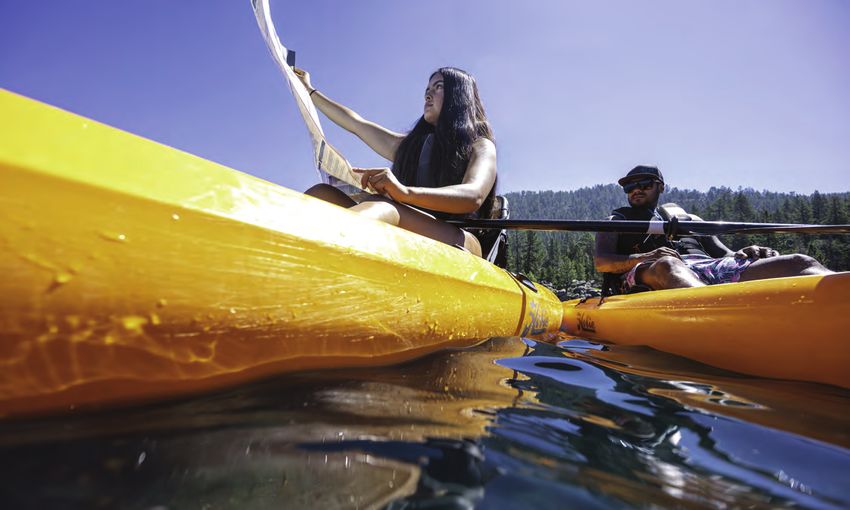
CONTENTS
     TH E L A K E TA H O E BA S I N ’ S C LI M ATE A DA P TATI O N
     AC TI O N P O R TFO LI O                                                         1
     Acknowledgements                                                                 2

     I NTRO D U C TI O N                                                              6
     Developing the Portfolio                                                         7
     Portfolio Structure                                                              9

     FUTU R E C LI M ATE CO N D ITI O N S                                             10
     TEM PER ATU RE                                                                   10
     PREC I PITATI O N                                                                10
     S N OWPACK                                                                       11
     D RO U G HT STRESS                                                               12
     RU N O FF                                                                        13
     WI LD FI RE                                                                      13
     L A K E LE V EL                                                                  14
     TH E L AK E SU B-SYSTEM                                                          15
     1.   Lake Clarity                                                                15
          1A .   Climate Impacts                                                      15
          1B.    Partnerships and Initiatives                                         16
          1C .   The Benefits of Adaptation vs. the Costs of Inaction: Lake Clarity   16
          1D.    Adaptation Actions                                                   17
     2.   Watershed Hydrology and Streamflow                                          18
          2A .   Climate Impacts                                                      18
          2B.    Partnerships and Initiatives                                         18
          2C .   Adaptation Actions                                                   19
     3.   Aquatic Biological Diversity                                                20
          3A .   Climate Impacts                                                      20
          3B.    Partnerships and Initiatives                                         21
          3C .   Adaptation Actions                                                   21
     4.   Groundwater Connected to the Lake                                           22
          4A .   Climate Impacts                                                      22
          4B.    Partnerships and Initiatives                                         22
          4C .   Adaptation Actions                                                   23
     5.   Improving Our Knowledge of the Lake                                         24

4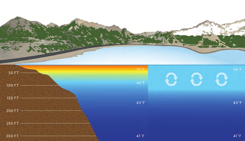
TH E U PL AN DS S U B-SYSTEM                                                 25
1.   Forest Ecosystem Dynamics and Soils                                     25
     1A .   Climate Impacts                                                  25
     1B.    Partnerships and Initiatives                                     25
     1C .   The Benefits of Adaptation vs. the Costs of Inaction: Wildfire   26
     1D.    Adaptation Actions                                               26
2.   The Biological Diversity of Forests                                     28
     2A .   Climate Impacts                                                  28
     2B.    Partnerships and Initiatives                                     28
     2C .   Adaptation Actions                                               28
3.   Wetlands, Riparian Areas, and Aquatic Wildlife                          29
     3A .   Climate Impacts                                                  29
     3B.    Partnerships and Initiatives                                     30
     3C .   Adaptation Actions                                               30
4.   Improving Our Knowledge of Uplands                                      32

TH E CO M M U N ITI ES S U B-SYSTEM                                          33
1.   Transportation Infrastructure                                           33
     1A .   Climate Impacts                                                  33
     1B.    Partnerships and Initiatives                                     35
     1C .   The Benefits of Adaptation vs. the Costs of Inaction:
            Landslides and Flooding                                          36
     1D.    Adaptation Actions                                               36
2.   Water, Power, and Communication Infrastructure                          38
     2A .   Climate Impacts                                                  38
     2B.    Partnerships and Initiatives                                     39
     2C .   Adaptation Actions                                               40
3.   Tribal Landscapes                                                       42
     3A .   Climate Impacts                                                  42
     3B.    Partnerships and Initiatives                                     42
     3C .   Adaptation Actions                                               42
4.   Recreation                                                              43
     4A .   Climate Impacts                                                  43
     4B.    Partnerships and Initiatives                                     44
     4C .   Adaptation Actions                                               45
5.   Public Health and Safety, including Wildfire and Emergency Response     46
     5A .   Climate Impacts                                                  46
     5B.    Partnerships and Initiatives                                     46
     5C .   Adaptation Actions                                               48
6.   Improving Our Knowledge of Communities                                  51

                                                                              5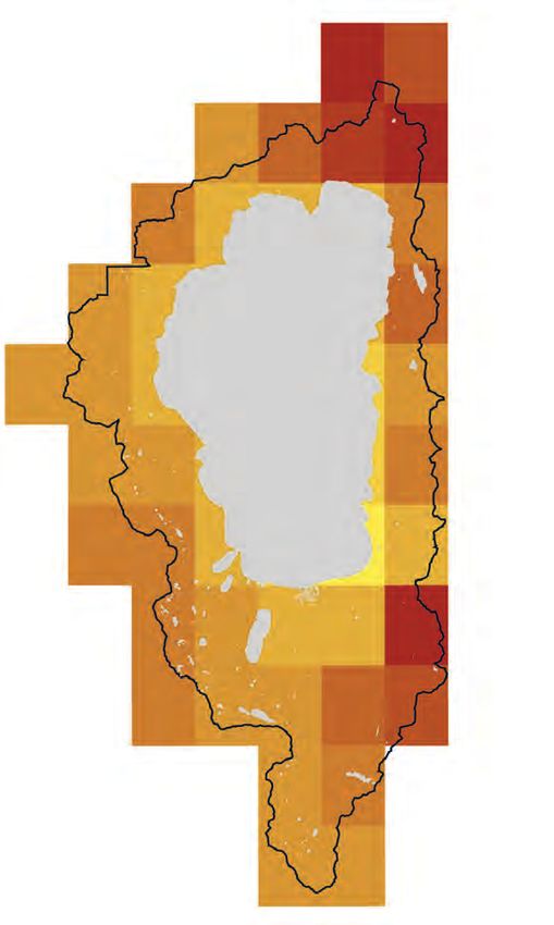
INTRODUCTION
    The Lake Tahoe Basin (Basin) combines nationally treasured natural resources with
    approximately 55,000 residents (2010 census) and an average annual visitation of 15
    million (Tahoe Prosperity Center). The region’s 501 square miles span spectacular
    waters, mountains, and forests, along with 20 communities, one city, and parts of
    five counties. Climate change threatens Tahoe with warmer temperatures and longer
    droughts, less snowpack, earlier runoff, more severe floods, increased erosion and
    shifts in lake level, and more severe wildfires, smoke, and heat. Adapting to climate
    change protects people and nature, makes infrastructure more resilient, and saves
    money. The Basin’s concentrated mix of people and nature make it a challenging yet
    promising landscape for adapting to climate change.

    The California Tahoe Conservancy (Conservancy) and Tahoe Transportation District
    (TTD) partnered with Basin agencies and stakeholders, and a team of technical ex-
    perts to conduct a scientific assessment of the vulnerability of the Lake, forests, and
    communities to climate change impacts (tahoe.ca.gov/climate-change); develop a
    Primer of major climate impacts and existing adaptation partnerships (tahoe.ca.gov/
    climate-change); and produce this Climate Adaptation Action Portfolio (Portfolio)
    that identifies adaptation actions that are already being undertaken. These three
    documents serve as a foundation for adapting to climate change at Lake Tahoe. This
    Portfolio can also help inform adaptation planning in other mountain communities
    throughout California and Nevada.

    A series of mandates and plans guide the adaptation work of public agencies and
    stakeholders in Tahoe. The states of California and Nevada have several laws, ex-
    ecutive orders, and policies that require state agencies to integrate climate change

6
adaptation into planning and investment, and to create corresponding programs and
regulations. Additionally, the Basin has concurrent regional and federal mandates that
guide climate planning and work. Public agencies have responded with corresponding
programs and ordinances. While many existing plans, such as the Lake Tahoe Regional
Transportation Plan (RTP), focus on mitigation, the Portfolio purposefully focuses on
adaptation. More detailed information on specific state and regional mandates guiding
climate adaptation work in the Basin can be found in the Primer.

Public agencies, businesses, and non-profit organizations in the Basin have been
implementing adaptation projects for many years and are committed to helping the
Basin’s population and environment adapt to future climate conditions. Basin partners
coordinate much of this work through the Lake Tahoe Environmental Improvement
Program (EIP). The EIP is an unparalleled partnership working to achieve the environ-
mental goals of the Region. Local, state, and federal government agencies, private
entities, scientists, and the Washoe Tribe of Nevada and California have collaborated
for nearly 25 years to restore the environmental health of Lake Tahoe. This land-
scape-scale collaboration is a partnership between nearly 80 public and private orga-
nizations. This Portfolio summarizes what many public agencies are already doing, or
will soon start to do, to accelerate adaptation in Tahoe, but is not an exhaustive list of
climate actions taking place in the Tahoe Basin. The intent is to showcase the ongoing
work agencies are undertaking to address the impacts of climate change, and to safe-
guard the quality of life, land, and waters in Tahoe. The Portfolio increases the aware-
ness of planners, scientists, engineers, and other experts about the leading edge of
adaptation work in the Basin, and helps them identify potential areas for collaboration
and multiple benefits.

DEVELOPING THE PORTFOLIO
The Conservancy commissioned a vulnerability assessment for the Basin in which a
Science and Engineering Team used downscaled climate data to better identify how
resources and communities will be impacted by climate change. The resulting Integrat-
ed Vulnerability Assessment of Climate Change in the Lake Tahoe Basin (IVA) provides
state-of-the-art information on how temperature and precipitation patterns will change,
and how these changes affect the vulnerability of the resources that people care about.
The IVA provides the foundation for this Portfolio. The resources assessed in the IVA
include aquatic resources, wildlife, groundwater, and vegetation; transportation, pow-
er, water, and communication infrastructure; and cultural landscapes, public health and
safety, and recreation. The IVA also analyzes the economic costs of climate change
impacts. The full IVA is available on the Conservancy website at https://tahoe.ca.gov/
programs/climate-change/. The impacts described in this Portfolio are drawn directly
from the IVA unless otherwise noted.

The Portfolio development process was iterative and some stakeholders including
agencies, jurisdictions, and organizations were not included in the original stakeholder
meetings. Through a series of workshops, stakeholders, with support from the Sci-
ence and Engineering Team, explored the implications of climate change impacts for
the three sub-systems (i.e., Lake, Uplands, Communities). Stakeholders representing
their own agencies or organizations were asked to identify the most significant actions

                                                                                       7
their agencies or organizations are taking to address the implications identified in
               the IVA (See Acknowledgements for the complete list of stakeholders). The Portfo-
               lio actions are self-reported and some agencies reported more robustly than others.
               Actions were constrained to those that are ongoing or have sufficient support (e.g.,
               funding, staffing, board direction) to begin soon. For each action, they specified why it
               is adaptive—in other words, how the action changes management in response to the
               anticipated impact for a resource. They also identified the specific management prac-
               tice, program, plan, or policy where the action occurs. This Portfolio does not include
               climate change mitigation.

               The Science and Engineering Team identified critical science, engineering, and eco-
               nomic research priorities for each sub-system that will help improve adaptation ac-
               tions (See “Improving Our Knowledge” sections for each sub-system). These align
               with the science priorities in the Tahoe Science Advisory Council (TSAC) Science to
               Action Plans for Lake Clarity and Uplands. Community research needs focused on
               transportation infrastructure based on the expertise of Energetics, a transportation
               and infrastructure consultant. Economic analyses of the benefits and costs of adapting
               to flooding and wildfire were conducted by Industrial Economics, Incorporated (IEc),
               unless otherwise noted.

               The Portfolio is a major step towards meeting California and Nevada mandates to
               adapt to climate change and provides a steppingstone towards future efforts. It high-
               lights how Basin partners have started adapting to climate change through numerous
               efforts. Through continued partnership, the Basin can get ahead of the climate change
               curve and ensure that everyone can enjoy its natural beauty and welcoming mountain

Photo courtesy of Lake Tahoe Water Trail
culture far into the future. Successful adaptation integrates climate science and eco-
nomics in building community resilience, resource management, infrastructure engi-
neering, and business operations. Some climate change impacts may be so significant
that they transform the ecology and culture of Tahoe. Adaptation will be necessary for
the foreseeable future and will necessarily involve many partners. The two states, the
Tahoe Regional Planning Agency (TRPA), the Washoe Tribe of Nevada and California
(Washoe Tribe), and numerous federal and local agencies have already started leading
the way. For details on what planning initiatives are already in motion and on the hori-
zon for these agencies please see the Primer.

PORTFOLIO STRUCTURE
People and nature cannot be easily separated at Lake Tahoe. The Basin’s geography,
geology, and ecology affect where people build roads and houses, the water they drink
and air they breathe, and the open spaces where they recreate. Lake Tahoe is, in other
words, a social-ecological system, and effective adaptation must involve each part of its
landscape. This Portfolio is divided into three constituent components that incorporate
a socio-ecological perspective for adapting to climate change.

The Portfolio first summarizes the future climate conditions for Lake Tahoe from the
IVA. The rest of the Portfolio, which includes impacts, partnerships, and initiatives is
organized around three sub-systems that make up the Basin – the Lake, its uplands,
and its communities. Implementing adaptation measures using this systems ap-
proach accounts for the connections between ecosystems and people; helps coordi-
nate investments; creates synergies and efficiencies; and should result in healthier
and more resilient landscapes. The three sub-systems cover the following topics:

       T H E L A K E S U B - S YS T E M addresses lake dynamics and clarity, aquatic
       resources, watershed hydrology and streamflow, and lake-connected ground
       water supply. The Lake Sub-system includes a costs and benefits analysis for
       protecting lake clarity through adaptation actions (See “The Benefits of
       Adaptation vs. the Costs of Inaction: Lake Clarity”).

       T H E U PL A N D S S U B - S YS T E M addresses biological diversity of the forest,
       forest ecosystem dynamics, and riparian, aspen, and meadow ecosystems.
       The Uplands Sub-system includes an analysis of the economic benefits and
       costs of adapting to wildfire (See “The Benefits of Adaptation vs. the Costs
       of Inaction: Wildfire”).

       T H E CO M M U N IT I E S S U B - S YS T E M addresses transportation, water, power,
       and communications infrastructure; cultural resources; recreation; and public
       health and safety. The Communities Sub-system also includes an analysis of
       the economic benefits and costs of adapting to flooding and landslides (See
       “The Benefits of Adaptation vs. the Costs of Inaction: Landslides and Flooding”).

Partnerships and initiatives are identified as examples of collaborative efforts to ad-
dress specific impacts and manage the affected resources.

                                                                                              9
FUTURE CLIMATE CONDITIONS
     The IVA provides detailed projections for temperature, precipitation, snowpack,
     drought stress, runoff, wildfire, and Lake level for future climate conditions, summa-
     rized here. The information and figures presented in this document come from the
     IVA and represent projections under the RCP 8.5 scenario unless otherwise noted.

     TEMPER ATURE
     The average ambient temperature in the Basin has been rising over the past decade,
     and this trend is expected to intensify in the future. Climate modeling predicts that
     by 2100 average annual temperatures will increase by 3.6 to 9 degrees Fahrenheit. In
     other words, summertime temperatures in South Lake Tahoe will be equal to those
     currently experienced in Napa and San Jose (see Figure 1).

       Figure 1. Average maximum
                                                      85ºF Projected 2099 Comparable to temps.
     temperature in South Lake Tahoe                  in Carson City and San Jose today
     for the month of August (historical
     and projected).                                  79ºF Projected 2050 Comparable to temps.
                                                      in Napa today
                                                      75ºF 1981–2010 Historical

     PRECIPITATION
     As average annual temperatures rise, evaporation rates are expected to increase,
     resulting in increased atmospheric water vapor and precipitation potential. Howev-
     er, total precipitation in the Basin is not expected to change significantly through
     2100. Instead, greater variability in year-to-year precipitation is expected, including
     more extreme droughts and storms. The amount of rainfall from the largest storms
     will increase by up to 30 percent.

10
SNOWPACK
Increased annual temperatures in the Sierra Nevada will cause the winter season
to shorten. The elevation at which snow accumulates (“snow level”) will eventually
rise above the Basin’s rim as less precipitation will fall as snow, and more will fall
as rain (see Figure 2). Snow will melt earlier in the spring and summer, and overall
snowpack will decline. At the same time, extreme snowstorms may become more
common with longer periods of drought in between.
Figure 2. Areas projected to retain snowfall in 2100, including location of
current ski resorts.
YEAR 2100 PROJECTION (RCP 8.5)
+9˚F increase in average annual
1
temperature from 2006
2 Snowfall likely (9,500 ft and above)
10
3 Rain more likely than snowfall
4
11 (6,200 ft up to 9,500 ft)
Rain likely (6,200 ft and below)
5
6 Lake Tahoe Basin Boundary
Lake
Ski Resorts
Tahoe
1 Boreal Mountain
7 2 Soda Springs
3 Sugar Bowl
4 Northstar
12
5 Squaw Valley
6 Alpine Meadows
7 Homewood
8
8 Sierra-at-Tahoe
9 Kirkwood Mountain
10 Mt. Rose
11 Diamond Peak
9
12 Heavenly Mountain
11DROUGHT STRESS
Climatic water deficit (CWD), the potential stress of drought on plants, is projected
to increase by more than 120 percent in some parts of the Basin by the end of the
century. The northern and eastern sides are expected to experience the most se-
vere increase in drought stress (see Figure 3).
Figure 3. Climate change increases drought stress on soils and plants
2070–2099 MODELED CLIMATIC WATER DEFICIT:
An Estimate of Drought Stress on Soils and Plants
> 120% increase
105–120% increase
91–105% increase
77–91% increase
62–77% increase
48–62% increase
34–48% increase
19–34% increase
5–19% increase
Projected percent difference from historical average
climatic water deficit 1950–2005 to projected
average climatic water deficit 2070–2099 (RCP 8.5)
12RUNOFF
Runoff, water draining from land, is projected to increase modestly in the Basin,
with large variability between years. However, peak runoff (when stream flow is
the highest) is projected to shift from the summer (June) to the winter (January),
a difference of five months (see Figure 4). Much more water will run off the land
during wintertime than historically because precipitation will fall more often as rain
than snow.
Figure 4. Timing of annual peak runoff shifts from June to January.
Month of Water Year
OCT NOV DEC JAN FEB MAR APR MAY JUN JUL AUG SEP
HISTORICAL
PEAK
RUNOFF
Average Monthly Runoff (inches)
1950–2005 0.08 0.23 0.24 0.18 0.19 0.31 0.75 1.80 2.72 1.13 0.13 0.03
Peak runoff shifts five months earlier
PROJECTED
PEAK
RUNOFF
2070–2099 0.07 0.56 1.21 2.71 1.60 1.38 1.15 0.70 0.19 0.03 0.04 0.09
WI LD FI RE
By 2100 the total area burned each decade is projected to be 61 percent larger than
in 2000, totaling approximately 33,000 acres per decade. By comparison, during the
2001-2010 decade approximately 3,187 acres burned (including the 2007 Angora Fire).
Low and mid-severity fire benefits conifer forests in Tahoe. However, high-severity
wildfire, which kills large numbers of trees and significantly reduces the tree canopy,
will become 89 percent more common than it is today by the end of the century.
13L AK E LE VEL
Lake Tahoe’s surface elevation (“lake level”) typically peaks in the summer months,
after the snowmelt has subsided and surface evaporation has overtaken inflows
from tributaries. The Lake serves as an important water supply reservoir, with a
dam at Tahoe City regulating lake level and downstream flows. The lake level is pro-
jected to frequently be outside the operable range of the dam. The Truckee River
Operating Agreement (TROA) establishes the maximum operable limit of the dam
to preserve the lakeshore environment, lakeshore structures, and to limit erosion.
Modeling shows that sometimes the lake level will be below the dam’s gated spill-
way, but most often the lake level will be above the maximum operational limit for
the dam (6,229 feet in elevation, see Figure 5). This is because of the expected in-
crease in the frequency and magnitude of extreme storms. If the lake level is above
the operable limit, the dam is physically unable to release water downstream at a
fast enough rate to avoid impacts to the lakeshore environment. The last time the
lake was more than three-tenths of a foot over its legal limit was over a century ago.
Figure 5. Histogram of annual peak lake surface elevations for the historical
period, and the RCP 4.5 and RCP 8.5 ensembles. Photos taken from Lake Tahoe
Dam in Tahoe City, looking toward Lake Tahoe.
H I STO G R A M O F PE A K A N N UA L E LE VATI O N O N L A K E TA H O E
80%
70%
60%
H I S TO R I C A L
P E RC E N T O F Y E A R S
50%
R C P 4. 5
40%
R C P 8. 5
30%
20%
10%
0%
Below Rim 6,223–6,226 ft 6,226–6,229.1 ft Above 6,229.1 ft
E L E VAT I O N O F L A K E TA H O E’ S S U R FAC E
6,222.83 ft 6,223.59 ft 6,227.97 ft
14TH E L AK E S U B-SYSTEM
The Lake is the ecological, social, and symbolic heart of Lake Tahoe. It is the de-
fining feature of the region’s ecology, the primary reason why people treasure the
landscape, and the basis of the economy. Its 72 miles of shoreline captivate beach-
goers, paddlers, hikers, homeowners, anglers, and tourists, offering quiet coves
and majestic vistas around each curve.
1. L AK E CL ARIT Y
1A . C LI M ATE I M PAC T S
Lake Tahoe is known worldwide for its exceptional clarity and brilliant blue color.
The mixing of the Lake’s warm and cold waters is a critical ecological process that
governs its chemistry, biology, and ecology—its health—and its famed clarity. Cli-
mate change, however, has begun to disrupt deep water mixing during the winter-
time (see Figure 6). In the future mixing will be less pronounced, which may create
compound impacts, including “dead zones”—areas of the Lake that lack dissolved
oxygen—and harmful algal blooms that further reduce Lake clarity and pose a hu-
man health risk.
Disruption to lake mixing is likely to lead to stream and storm water becoming
trapped closer to the surface of the Lake, simultaneously trapping sediment and
nutrients near the shore instead of mixing them throughout the Lake. This may
increase algal growth near the beaches where people recreate. More frequent and
Figure 6. Diminished mixing threatens Lake Tahoe’s clarity
C RYS TA L BAY
SUMMER WINTER
WAR M E R , LO N G E R S H O RTE R WI NTE RS mean the lake
S U M M E RS keep the lacks time to mix all the way to the
lake stratified longer. bottom. Lack of oxygen renewal
leads to the release of nutrients and
15
metals from sediments.severe wildfires, as well as larger and more frequent flooding, could also increase the
amount of sediment that flows into the Lake. Irregular mixing will likely lead to an
increase in dead zones and in turn release large amounts of nutrients like orthophos-
phate and ammonium that further fuel algal blooms. Additionally, algal blooms that
make people and animals sick may increase in extent, frequency, and duration.
1B . PA R TN E R S H I P S A N D I N ITI ATI V E S
Lake Tahoe has one of the United States’ premier Total Maximum Daily Load (TMDL)
plans, which provides a science-based approach to restoring and protecting the lake’s
historical clarity. It establishes targets for implementing agencies to reduce storm water
pollution from developed lands. The interagency Storm Water Quality Improvement
Committee (SWQIC) consists of implementing agencies, regulators, funding agencies,
and other partners. SWQIC facilitates the design, delivery, and effectiveness of storm-
water quality improvement efforts to achieve Lake Tahoe clarity goals. The Lahontan
Regional Water Quality Control Board (Lahontan Water Board) and Nevada Division of
Environmental Protection (NDEP) oversee the program. Partners use the reporting tools
on the Lake Tahoe Info (https://laketahoeinfo.org) website to track progress.
Tahoe Water Suppliers Association (TWSA) is a Lake Tahoe-based partnership consisting
of municipal water agencies dedicated to providing and protecting clean drinking water
for residents and visitors of the Basin. The mission of TWSA is to develop, implement,
and maintain an effective watershed control program; advocate for the protection of
Lake Tahoe as a viable source of drinking water; and satisfy additional state and federal
requirements. The actions of this partnership serve to minimize declines in Lake Tahoe
water quality and subsequent increases in water supply treatment costs, effects that
result from increased thermal stratification in the Lake due to climate change.
The Nearshore Agency Working Group (NAWG) coordinates nearshore monitoring ef-
forts and program activities and includes representatives from the U.S. Environmental
Protection Agency (EPA), NDEP, Tahoe RCD, Lahontan Water Board, and TRPA.
1C . TH E B E N E FIT S O F A DA P TATI O N VS . TH E CO ST S O F
I N AC TI O N : L A K E C L A R IT Y
Decreased lake clarity has economic as well as social and ecological impacts. Water
quality impacts property prices, although with Lake Tahoe’s historic high lake clari-
ty this impact may not be observed for a long time. Reduced water quality (from the
aforementioned thermal stratification) can increase the costs of treating domestic
water supplies, increase the risk of waterborne illness, and decrease the enjoyment
people derive from water-based recreation.
Numerous actions can reduce the negative effects of flooding on lake clarity. Such ac-
tions would provide environmental and economic co-benefits by safeguarding lake clar-
ity while better protecting communities. The goals would be to increase the infiltration
of rainfall into groundwater, and to reduce the velocity of storm water runoff during
peak flooding. Investments could include increasing vegetation cover, constructing
retention ponds to settle sediment, terracing slopes to slow flows, constructing flood-
ways to divert sediment, and stabilizing highly erosive slopes.
16Other actions can further enhance storm water management efforts as a co-ben-
efit. The Lake Tahoe West Restoration Partnership (LTW), for example, is working
collaboratively across all jurisdictions to restore the resilience of the 59,000 acres
of forest that cover Lake Tahoe’s west shore. Modeling from this initiative showed
that sediment runoff increases following wildfire, hence reducing the occurrence or
severity of wildfire would help protect lake clarity. Estimating the economic benefits
of adapting to wildfire could examine how many tons of sediment are expected with
and without wildfire, how each ton impacts clarity, and how much people would
pay for improved clarity. The Lake Tahoe TMDL program’s data on load reductions
provides a ready source of information for such analysis.
1D. A DA P TATI O N AC TI O N S
A S S ES S M E NT A N D A DA P TI V E M A N AG E M E NT
A. At the request of Nevada Department of Conservation & Natural Resources
(DCNR) and California Natural Resources Agency (CNRA), the TSAC is leading
implementation of the Lake Tahoe Science to Action Plan. The initiative seeks to
understand why the Lake’s clarity is worsening in summer despite improving in
winter, and to identify what actions public agencies can take to stem this. TSAC
is working with the Lahontan Water Board, NDEP, and TRPA to review findings,
expand the transfer of knowledge, and integrate recommendations in regional
implementation and monitoring. TSAC will then update and improve the Lake
Tahoe Clarity Model.
B. TRPA is leading the update of the Basin’s environmental threshold carrying ca-
pacities established to safeguard the environment and limit development im-
pacts to the Lake.
C. Lahontan Water Board, NDEP, U.S. EPA, and TRPA will continue to work with
the science community to review protocols for nearshore monitoring of climate
change-driven alterations in algal growth.
D. TSAC will work with Basin partners to develop priority models for Lake Tahoe
that advance knowledge and accelerate climate change adaptation.
E. TSAC will initiate annual briefings to engage in the TMDL adaptive management
process to help ensure that new scientific findings inform resource management
and related Lake Tahoe Environmental Improvement Program (EIP) investments.
The process will prepare integrated analyses of Lake, watershed, and climate
conditions.
STO R M WATE R I N FR A STRU C TU R E
A. Lahontan Water Board, NDEP, and TRPA will work with urban-TMDL-implementing
partners to assess how significantly performance of existing treatment best man-
agement practices (BMPs) may be anticipated to change under more contempo-
rary and future climate regimes and inform stormwater managers if and how the
current design standard has or will change in time. The agencies will also work to
investigate potential new and enhanced treatment BMPs and practices that have
not previously been implemented in the Basin for suitability of application.
17B. Nevada Tahoe Conservation District (NTCD) partners with Nevada Department
of Transportation (NDOT) and Douglas County to continuously assess BMP
performance, perform adaptive management, and analyze sites for retrofit.
E N V I RO N M E NTA L A N D PU B LI C H E A LTH
A. Lahontan Water Board will continue to collaborate with county environmental
health departments, homeowner associations, utility districts, USDA Forest
Service, Lake Tahoe Basin Management Unit (LTBMU), and other partners to build
programs to monitor and investigate harmful algal blooms. The goal is to better
protect human and animal health when harmful levels of cyanotoxins are present
in surface waters used for recreation and domestic water supply.
B. NTCD partners with U.S. Geological Survey (USGS) and Tahoe Resource
Conservation District (Tahoe RCD) to monitor Lake Tahoe for nearshore
human health concerns.
O UTR E AC H A N D A DVO C AC Y
A. El Dorado County will conduct public outreach based on its National Pollutant
Discharge Elimination System (NPDES) program and provide information to home-
owners and business about how they can readily implement storm water BMPs.
2. WATERSHED HYD RO LOGY AND STRE AMFLOW
2 A . C LI M ATE I M PAC T S
The naturally high variability in the amount of snow that accumulates and runoff
that occurs in the Basin between the winter and summer seasons, and across years,
will increase even further with climate change. Larger storms will become more
frequent, leading to higher peak flows of runoff, and corresponding increases in
erosion, transport of pollutants, and infrastructure damage.
A smaller snowpack will also hold less water. Rather than the snowpack melting
steadily into the summer, the Basin’s hydrology could shift dramatically, with peak
streamflow occurring months earlier. Ecological changes would be correspondingly
severe, particularly for riparian ecosystems.
2 B . PA R TN E R S H I P S A N D I N ITI ATI V E S
The interagency Upper Truckee River Watershed Advisory Group (UTRWAG) co-
ordinates and shares information about landscape restoration all along the Upper
Truckee River. The river is the most significant source of sediment to Lake Tahoe
(with corresponding impacts to lake clarity), and the most extensive and biological-
ly diverse wetland and marsh complex in the Basin. California Department of Parks
and Recreation (DPR), LTBMU, Tahoe RCD, the City of South Lake Tahoe, and the
Conservancy have invested over $70 million in restoration through five major proj-
ects. The goal is to restore all nine miles of the river and over 1,000 acres of flood-
plain, which increase the sediment filtering capacity.
18The LTW is working collaboratively across all jurisdictions to restore the resilience
of the 60,000 acres of forests, watersheds, and communities that cover Lake
Tahoe’s west shore. Disturbances addressed by LTW include flooding, drought,
insects and disease, and wildfire, all of which climate change is amplifying. The LTW
initiative is restoring the resilience of west shore forests, watersheds, and commu-
nities to flooding, drought, insects and disease, and wildfire as amplified by climate
change. Cardinal goals related to hydrology are to restore creeks and floodplains
that provide clean water, habitat, and buffering from floods as well as droughts; and
to restore aquatic ecosystems, that support viable populations of native species.
2C . A DA P TATI O N AC TI O N S
R I V E R A N D STR E A M R ESTO R ATI O N
A. Tahoe RCD, DPR, Conservancy, LTBMU, El Dorado County, and the City of South
Lake Tahoe will each continue restoring the Upper Truckee River (UTR) on their
lands, including Johnson Meadow, the Lake Tahoe Golf Course, and the Upper
Truckee River Marsh (UTM). Partners will also continue monitoring and adaptively
managing already completed stretches of UTR restoration. The U.S. Army Corps
of Engineers (USACE) will continue funding numerous watershed restoration
projects, including the UTM and Johnson Meadows.
B. DPR, Tahoe RCD, Nevada Tahoe Resource Team (NTRT), NTCD, LTBMU, and the
Conservancy will each plan, fund, and implement wetland and stream restoration
projects on their lands that can accommodate increased flooding, withstand
prolonged drought, and serve as climate refuges for native species. High-priority
projects include Antone Meadows, Tahoe State Recreation Area, Burke Creek/
Rabe Meadow, Marlette Creek, and Polaris Creek.
C. The Conservancy will complete a document about the Greater Upper Truckee Wa-
tershed Restoration that communicates the range of restoration and recreational
achievements and future improvements that partners are leading. The document
will also identify opportunities for integrated landscape resilience, mitigation, and
adaptation.
D. Incline Village General Improvement District (IVGID) facilitates creek restorations
for Third, Rosewood, and Incline Stream Environment Zones (SEZs). Creek resto-
rations focus on enhancing channel flows, reducing sedimentation and providing
a healthy aquatic ecosystem for natural species to thrive.
L A N DS C A PE-S C A LE H Y D RO LO GY
A. TSAC will assess mitigation measures designed to offset potential impacts from
landscape-scale forest management practices like vegetation thinning and pre-
scribed burning. The work will advance hydrologic modeling conducted for the
LTW initiative and inform enhancements of the Lake Tahoe Clarity Model.
193. AQUATIC BIO LOG IC AL D IVERS IT Y
3A . C LI M ATE I M PAC T S
Climate change will negatively influence a range of species that inhabit Lake Tahoe’s
waters, from the main body of water to its tributaries to the small lakes throughout
the region. Spawning and rearing habitat for native fish will be impacted as cool wa-
ter is less likely to be available in streams in the late spring and early summer, due
to the peak runoff shifting earlier in the year (see Figure 7). Fish species and aquatic
organisms that are less tolerant of warmer water will be particularly vulnerable.
Aquatic invasive species (AIS) are generalists that adapt well to altered environ-
ments and thus are likely to outcompete native species. Longer summers and warm-
er surface water temperatures will mean that AIS populations will likely proliferate,
and may expand to more parts of the Lake, streams that drain into it, and nearshore
environments including marinas. Native biological diversity has evolved with Tahoe’s
geological and chemical processes and plays a key role in cycling nutrients and par-
ticles that drain from the watershed into the Lake. Expansion of AIS populations and
the disruption they cause to ecological processes may also reduce lake clarity.
Figure 7. Multiple climate impacts degrade native fish habitats.
Earlier stream water runoff
More frequent fires lead to increased erosion
Incline Village
Intensified urban storm water runoff
Wet Year Shoreline C RYS TA L BAY
Drought Year Shoreline
I N FLOWS O F RU N O FF may get trapped closer to the surface, reducing
clarity and adding nutrients (nitrogen + phosphorous) and sediment
I N C R E AS E D AQUATIC I NVAS IVE S PEC I E S outcompete
fish species
FLUCTUATI N G
L AK E LE VE LS and
earlier stream peak runoff may impact
the ab20
ility of native fish species to reproduce3 B . PA R TN E R S H I P S A N D I N ITI ATI V E S
The Lake Tahoe AIS Coordinating Committee (LTAISCC) is a multi-agency team that
prevents new AIS from establishing themselves in Lake Tahoe, controls the existing
populations in the Lake, and conducts lakewide monitoring. LTAISCC standardizes
data collection and treatment methods, shares information and resources, coor-
dinates education and outreach, secures grant funding, prioritizes projects, and
implements prevention and control projects. Primary field activities include rapidly
detecting and removing any new AIS arrivals and inspecting any watercraft entering
the Basin.
LTAISCC developed an AIS Action Agenda to provide resource managers with a
comprehensive control strategy. The AIS Action Agenda addresses current and
emerging threats and defines outcome-based performance metrics. It stresses the
need to increase management capacity and thereby increase the pace of AIS control
efforts, including comprehensive control targeting invasive fish, invertebrates, and
amphibians in addition to invasive plants.
Lake Tahoe’s Watercraft Inspection Program inspects every motorized watercraft to
ensure it is clean, drained, and dry and not carrying AIS into Lake Tahoe.
The Nearshore Aquatic Weed Working Group (NAAWG) coordinates the various
efforts underway to control and, where possible, eradicate populations of aquatic
invasive plants in the nearshore of Lake Tahoe.
3C . A DA P TATI O N AC TI O N S
A I S PR E V E NTI O N A N D M O N ITO R I N G
A. Tahoe RCD and TRPA will establish permanent watercraft inspection stations to
increase capacity to process watercraft entering Lake Tahoe’s waters. The sta-
tions are the critical first line of defense in preventing AIS from being introduced.
B. The LTAISCC will increase and improve multijurisdictional monitoring to rapidly
detect and eradicate new and expanding AIS populations.
C. The USACE will continue supporting partners via funding from the Tahoe 108
Program for invasive species management to control aquatic invasive species
in Lake Tahoe and prevent new exotic species from being introduced, including
monitoring, prevention, public outreach, and boat inspections.
D. California Department of Fish and Wildlife (CDFW) will continue to quarantine
vessels that test positive for invasive mussel species and release those vessels
following decontamination.
A I S CO NTRO L
A. The LTAISCC will use the AIS Action Agenda to guide strategies that increase the
pace and scale of control projects.
B. Tahoe RCD, TRPA, NTRT, NDSL, and DPR will each use new technologies and
climate scenarios to increase the speed, efficiency, and effectiveness of projects
21that control current infestations and restore the nearshore. Attention will first
focus on (but extend beyond) iconic areas like Emerald Bay and Lake Tahoe Ne-
vada State Park.
C. NTRT and NDSL will continue to provide financial support to partners and re-
search institutions for AIS prevention, control and monitoring projects identified
in the AIS Action Agenda.
D. DPR will partner with University of California Davis to expand the control of
mysis shrimp, hypothesized to contribute to diminished lake clarity, and associ-
ated research in Emerald Bay. This work will inform large-scale actions to reduce
shrimp populations throughout Lake Tahoe.
E. Tahoe RCD will investigate the feasibility of updating marina and mooring infra-
structure designs to accommodate larger fluctuations in lake elevation, reduce the
spread of AIS, and improve navigation and water flow in areas constrained by AIS.
N ATI V E FI S H S PEC I ES
A. Nevada Department of Wildlife (NDOW) and CDFW will further assess Lahontan
cutthroat trout recovery opportunities and increase hatchery capacity. CDFW will
expand existing tools for native fish conservation. NDOW will continue Lahontan
cutthroat trout reintroduction work on Third Creek.
B. During stream restoration, NTCD, IVGID, and NDSL are removing barriers for aquat-
ic organisms to promote fish passage in historical creek reaches.
C. The LTBMU is monitoring stream temperature in various tributaries to guide man-
agement efforts needed for the conservation, enhancement, and/or restoration of
habitat for growth, reproduction, and survivorship of native aquatic species.
4. GROU NDWATER CO NNECTED TO THE L AK E
4A . C LI M ATE I M PAC T S
Groundwater sustains the creeks, meadows, and wetlands that are home to diverse
fish, animals, plants, and cultural resources. Historically, groundwater has kept
these areas flourishing long into the summer. On the south shore, deep ground-
water tables provide the primary source of drinking water. The groundwater basins
that are connected to the Lake (so-called “low elevation groundwater”), maintain
their levels despite decreased infiltration, and this also minimizes the impacts of
pumping for domestic water supplies. These groundwater basins are therefore ex-
pected to be resilient to climate change unless the Lake’s level drops precipitously.
4 B . PA R TN E R S H I P S A N D I N ITI ATI V E S
Public utility districts play the primary role in managing the Basin’s groundwater. In
particular, the South Tahoe Public Utility District (STPUD) manages groundwater for
domestic water supplies on the south shore. The Tahoe-Sierra Integrated Regional
Water Management Group, which involves numerous Basin partners, pursues state
and federal funding to address long-term and emerging water resource challenges.
22STPUD developed the Tahoe Valley South Basin 2014 Groundwater Management
Plan (GWMP) with partners to manage groundwater supplies and protect groundwa-
ter quality. Following the requirements established by the Sustainable Groundwater
Management Act, this plan fulfills STPUD’s responsibility to develop and implement
a groundwater sustainability plan that meets the long-term goals of the ground-
water basin and ensures that it is operated within its sustainable yield, without
causing undesirable effects. In May 2020, STPUD adopted a resolution to update the
2014 GWMP, which will be completed by January 2022. This plan addresses local cli-
mate change impacts, including changes in precipitation, snowmelt, timing in peak
streamflow, and frequency and intensity of droughts, which could warrant substan-
tial changes in local groundwater management and planning (STPUD 2020).
The League to Save Lake Tahoe runs the Pipekeeper Program, a citizen science
program to address stormwater runoff into Lake Tahoe, and Snapshot Day for Water
Clarity, an annual citizen science water quality monitoring event.
4C . A DA P TATI O N AC TI O N S
WATE R A N D WA STE WATE R I N FR A STRU C TU R E
A. Lahontan Water Board will address infrastructure vulnerabilities of water and
wastewater utilities through four actions:
i. Adopt new, re-issue, or amend permits that identify requirements to reduce
vulnerability through site-specific or project-specific discharge plans.
ii. Develop guidance for permitting (e.g., administrative procedures manuals) to
address vulnerability and climate change impacts on regulated facilities.
iii. Encourage (possibly through permit requirements and enforcement actions)
utility districts to prepare and submit risk abatement plans for building resil-
ient and safe infrastructure.
iv. Urge (possibly through permit requirements and enforcement actions) com-
munities, utilities, and water agencies that have completed risk assessments
to increase resilience by upgrading and improving infrastructure.
B. NDOT and Douglas County, with help from NTCD, are building a stormwater de-
cant facility on Kingsbury Grade to localize maintenance and provide state of the
art decant water treatment.
C. Tahoe City Public Utility District (TCPUD) will reduce reliance on groundwater for
drinking water and fire suppression needs by constructing and maintaining the
West Lake Tahoe Regional Water Treatment Plant, a facility designed to utilize
and treat surface water from Lake Tahoe.
WATE R CO N S E RVATI O N
A. Lahontan Water Board will promote drought resilience by supporting projects
and practices that use water more wisely, eliminate water waste, and reuse water
for multiple purposes where possible. Lahontan Water Board will coordinate with
State Water Resources Control Board staff and relevant partner agencies to iden-
23tify and recommend actions to effectively permit projects that develop new and
underutilized water resources, expand surface water and groundwater storage
where appropriate, and add operational flexibility to build and enhance resilience
to climate change.
B. TCPUD will continue to implement new technology through SMART meter in-
stallation designed to improve leak detection and usage reporting and promote
water conservation measures for commercial and residential water use.
G RO U N DWATE R M O N ITO R I N G
A. All public utility districts in California will monitor groundwater elevations within
aquifers used for drinking water. If they observe declining trends, they will ad-
just pumping schedules to maintain groundwater levels above minimum pump-
ing thresholds. In low priority aquifers there is no regulated threshold. (General
Improvement Districts (GIDs) on the Nevada side of Lake Tahoe get water from
Lake Tahoe itself and therefore do not conduct groundwater monitoring).
5. IMPROVING OU R K NOWLEDGE O F THE L AK E
Critical topics for further investigation include:
• Assessment of the hydrodynamics of Lake Tahoe under various climate scenarios
• Modeling of the hydrology, relative vulnerability, and sediment delivery of the
Basin’s 63 individual drainages
• Improved forecasting of flooding
• Surface and groundwater dynamics, and hence understanding of water supply to
downstream communities
• Better understanding of the relationship between mysis shrimp, native daphnia,
other zooplankton, and their impact on lake clarity
• Expanded assessment of the effectiveness and economics of different resto-
ration, AIS control, resilience-building, and adaptation actions
• Applying historical and current climate data to Basin projects that assess and
model the Lake
• Conducting statistical analysis and monitoring key climate change metrics associ-
ated with meterology, hydrology, pollutant loading, and storm water management
• Evaluating how nearshore aquatic resources respond to climate change, including a
combination of historical and ongoing remote sensing data and geospatial analysis
• Assessing how climate change is impacting lake physiodynamics and clarity
24U PL AN D S U B-SYSTE M
Lake Tahoe’s conifer forests, streams, and meadows are home to an array of birds,
mammals, and fish. These upland ecosystems also provide the trails, resorts, and
open spaces where people recreate, venture into the backcountry, and reconnect
with nature. They are integral to the quality of environment and life in the Basin.
1. FOREST ECOSYSTEM DYNAMICS AND SOILS
1A . C LI M ATE I M PAC T S
As droughts become more severe, the loss of drought-sensitive vegetation and
dependent wildlife, increase in insect and disease outbreaks, and increases in the
frequency and extent of wildfire are expected to cause long-term changes in forest
structure and composition. The death of large numbers of trees will increase the
risk that wildfire will burn entire stands of trees and release all the carbon they con-
tain into the atmosphere. Altogether, climate change will alter biological, geologi-
cal, and chemical cycles, and undermine vital ecosystem processes and services.
1B . PA R TN E R S H I P S A N D I N ITI ATI V E S
The LTW is working collaboratively across all jurisdictions to achieve multiple goals
including helping forests recover from fire, drought, and insect outbreaks; and en-
suring that fires burn primarily at low to moderate severity and provide ecological
benefits. Key strategies are to increase the pace and scale of forest thinning and in-
crease the use of prescribed fire as a landscape restoration tool. Through LTW, the
Conservancy, LTBMU, and DPR will adaptively manage and monitor effectiveness.
DPR will continue their 30+ year prescribed fire and forest management program in
coordination with other LTW prescribed fire plans to continue and expand upon for-
est restoration. Lahontan Water Board will partner, collaborate, and provide techni-
cal support for LTW and similar efforts.
The Tahoe-Central Sierra Initiative (TCSI) aims to protect communities and restore
forest and watershed health to 2.4 million acres of the Sierra Nevada, including the
Basin. The Conservancy, Sierra Nevada Conservancy, LTBMU and Tahoe and Eldora-
do National Forests, University of California, The Nature Conservancy, National For-
est Foundation, and California Forestry Association jointly lead the initiative. TCSI
links eight landscape-level collaboratives to establish a regional model for resilience
and forest restoration. Partners have secured over $32 million in California Climate
Investments grant funds to implement high-priority forest health projects that
sequester carbon and reduce the risk of wildfires. Projects are currently thinning
20,000 acres, removing 164,000 tons of biomass, and implementing 8,000 acres of
prescribed fire across ownerships and jurisdictions.
The Tahoe Fund has identified forest health as its number one priority and has
launched the Smartest Forest Fund, a sub-fund of its Environmental Venture Trust,
to use philanthropy to drive innovative forest health initiatives. The fund’s goals
are to expedite planning and implementation of forest restoration projects; use
25technology to enhance wildlife studies and harvesting plans; find new outlets for
excess vegetative fuel; and prepare the community for wildfire evacuation (Tahoe
Fund 2020a). The Smartest Forest Fund addresses climate change impacts such as
increased wildfire risk, degraded forest health due to drought, disease, and bark
beetle outbreaks.
1C . TH E B E N E FIT S O F A DA P TATI O N VS . TH E CO ST S O F
I N AC TI O N : W I LD FI R E
The economic analysis conducted for this Portfolio demonstrates that adapting to
wildfire provides significantly greater benefits than costs. By reducing the severity of
future wildfires, each $1 million invested in forest management actions would reduce
property damages by $10 million.
The study found that the net value of benefits would be ten times greater than pre-
vention treatment costs, primarily because of avoided property losses, followed by
avoided smoke impacts. Thinning produced benefits across all categories, property,
carbon, and smoke. Prescribed burning produced larger property benefits with signifi-
cantly smaller smoke benefits and does not provide a carbon sequestration benefit
compared to thinning. The study noted that it likely underestimated benefits because
it lacked data for the benefits that accrue to other resources from less severe fire.
1D. A DA P TATI O N AC TI O N S
FO R EST H E A LTH
A. Placer County, DPR, NTRT, Nevada Division of Forestry (NDF), LTBMU, the Con-
servancy, and other Tahoe Fire and Fuels Team (TFFT) members, will continue to
increase the pace and scale of forest health projects while enhancing landscape
resilience and improving wildlife habitat. Projects will include the strategic use
of prescribed fire, consistent with the most recent scientific research, to cost-ef-
fectively treat larger landscapes for wildland fuel accumulation while providing
ecological benefits that increase climate resilience.
B. NTCD, NTRT and NDF will continue to work with local fire districts to prioritize
forest health projects in areas where riparian restoration can also be accom-
plished to provide the greatest ecosystem benefits.
B I O M A S S UTI LIZ ATI O N
A. NTRT and NDF will explore opportunities to remove biomass using energy-effi-
cient methods, and to utilize associated forest restoration byproducts.
B. Placer County will continue to implement its strategic Wildfire Protection and
Biomass Utilization Program to minimize the risk of wildfire and use biomass to
produce heat and electrical power.
C. TFFT will increase the use of restoration byproducts to offset fuel treatment
costs and simultaneously accelerate climate adaptation.
26D. Sierra Business Council (SBC) will continue to educate and advocate for bio-
mass utilization and bioenergy facilities to restore forest health, offset public
safety power shutoff impacts, and furnish well-paying, year-round employment.
This includes policy changes, collaboration with land managers, market-based
approaches like California’s Bioenergy Marketing Adjusting Tariff, and piloting
technologies with the Sierra Institute’s Build Community Program and the Rural
Economic Development Wood Utilization Innovations Team.
C A R BO N S EQ U ESTR ATI O N
A. DPR will model 25 years of change in forest structure and how it will influence
fire behavior. They will also analyze the stability of live tree carbon, and the re-
tention of aboveground carbon stocks in the event of a wildfire.
B. The Conservancy will use California Climate Investments funding combined with
analytical tools developed in TCSI to maximize the carbon benefits of forest
treatments, and streamline efficiency within the Basin such as on its Dollar Creek
and biomass transportation projects.
C. California Department of Forestry and Fire Protection (CAL FIRE) currently releas-
es an annual Forest Ecosystem and Harvested Wood Product Carbon inventory.
They will work with partners to model different forest management and utiliza-
tion scenarios and associated impacts on carbon sequestration rates and stocks.
N E W M A N AG E M E NT AG R E E M E NT S A N D R EG U L ATI O N S
A. LTBMU and Conservancy will use an existing Good Neighbor Authority agree-
ment to work collaboratively to accelerate fuel reduction treatments in the wild-
land-urban interface (WUI), including on urban lots. LTBMU and the Conservancy
will use a forthcoming federal-state shared stewardship agreement to accelerate
forest restoration programs in the Basin, including securing private investment.
B. The Conservancy will update their forest management guidelines to anticipate
future climate conditions and fire behavior, and augment training for field staff
and expand inspections to identify insect and disease infestations.
C. Per California Senate Bill 901 (2018), Lahontan Water Board will develop permits
and conduct outreach, inspections, and reviews for managing vegetation and
wildfire in utility corridors. Lahontan Water Board will revise or develop new
regional permits to facilitate timber harvesting under Forest Practice Rule ex-
emptions while mitigating water quality impacts, and with CAL FIRE will inspect
and report on the use and efficacy of these exemptions. Finally, Lahontan Water
Board will develop policies and permits that support the reintroduction of fire,
thinning practices, and infrastructure (e.g., lumber mills and biofuel-generation
plants) to protect the integrity and resilience of forested landscapes and mini-
mize wildfire.
D. TRPA will invite Basin partners that regulate and implement forest health treatments
to work towards a regional approach to forest restoration and will continue to collab-
oratively lead the review of regulations to remove impediments to adaptation.
27You can also read